Annular solar eclipse of 12/20/-0744
| Day of week: | Monday |
| Maximum duration of eclipse: | 11m26s |
| Maximum width of eclipse path: | 311 km |
| Saros cycle: | 49 |
| Coverage: | 92.1% |
| Magnitude: | 0.9207 |
| Gamma: | 0.2595 |
Wo kann man die Sonnenfinsternis vom 12/20/-0744 sehen?
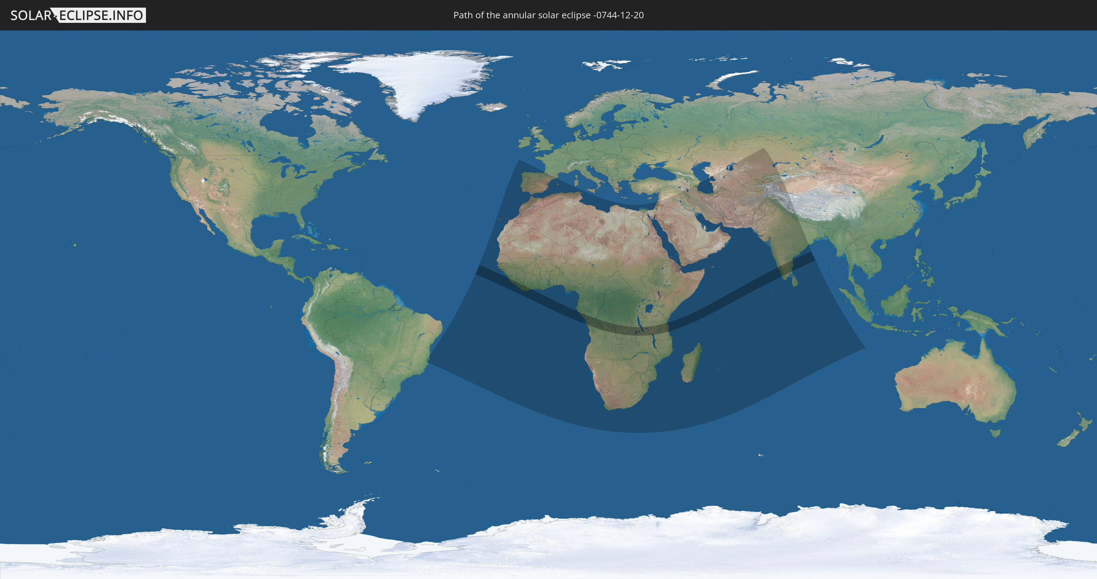
Die Sonnenfinsternis am 12/20/-0744 kann man in 93 Ländern als partielle Sonnenfinsternis beobachten.
Der Finsternispfad verläuft durch 12 Länder. Nur in diesen Ländern ist sie als annular Sonnenfinsternis zu sehen.
In den folgenden Ländern ist die Sonnenfinsternis annular zu sehen
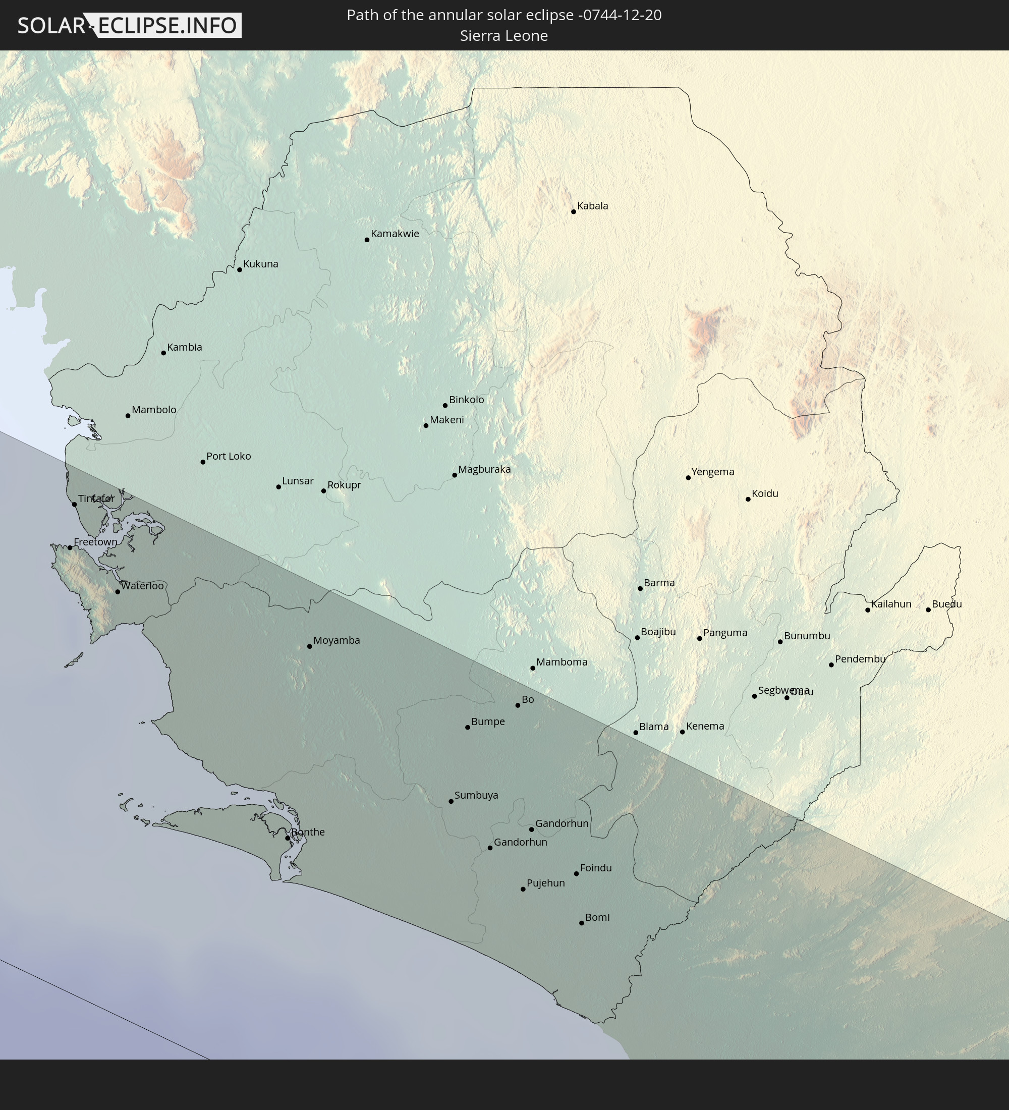 Sierra Leone
 Liberia
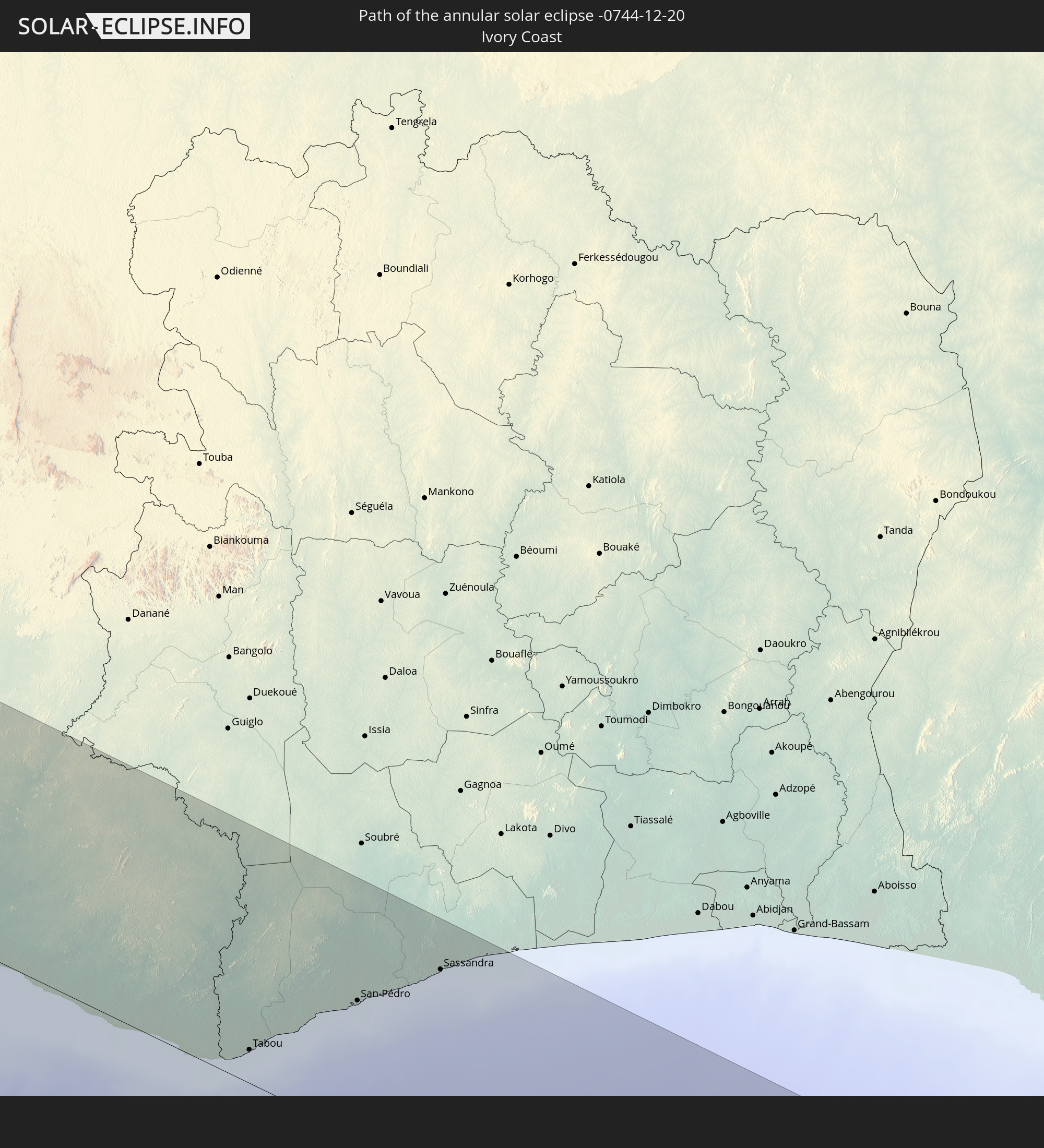 Ivory Coast
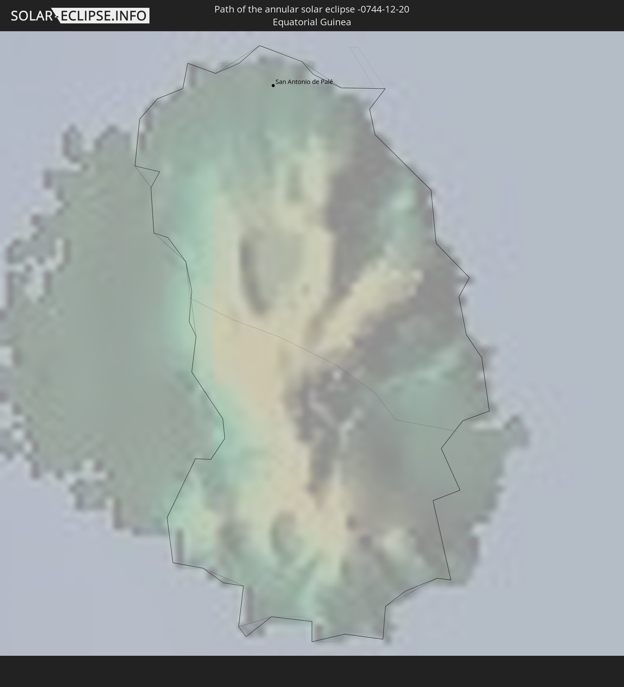 Equatorial Guinea
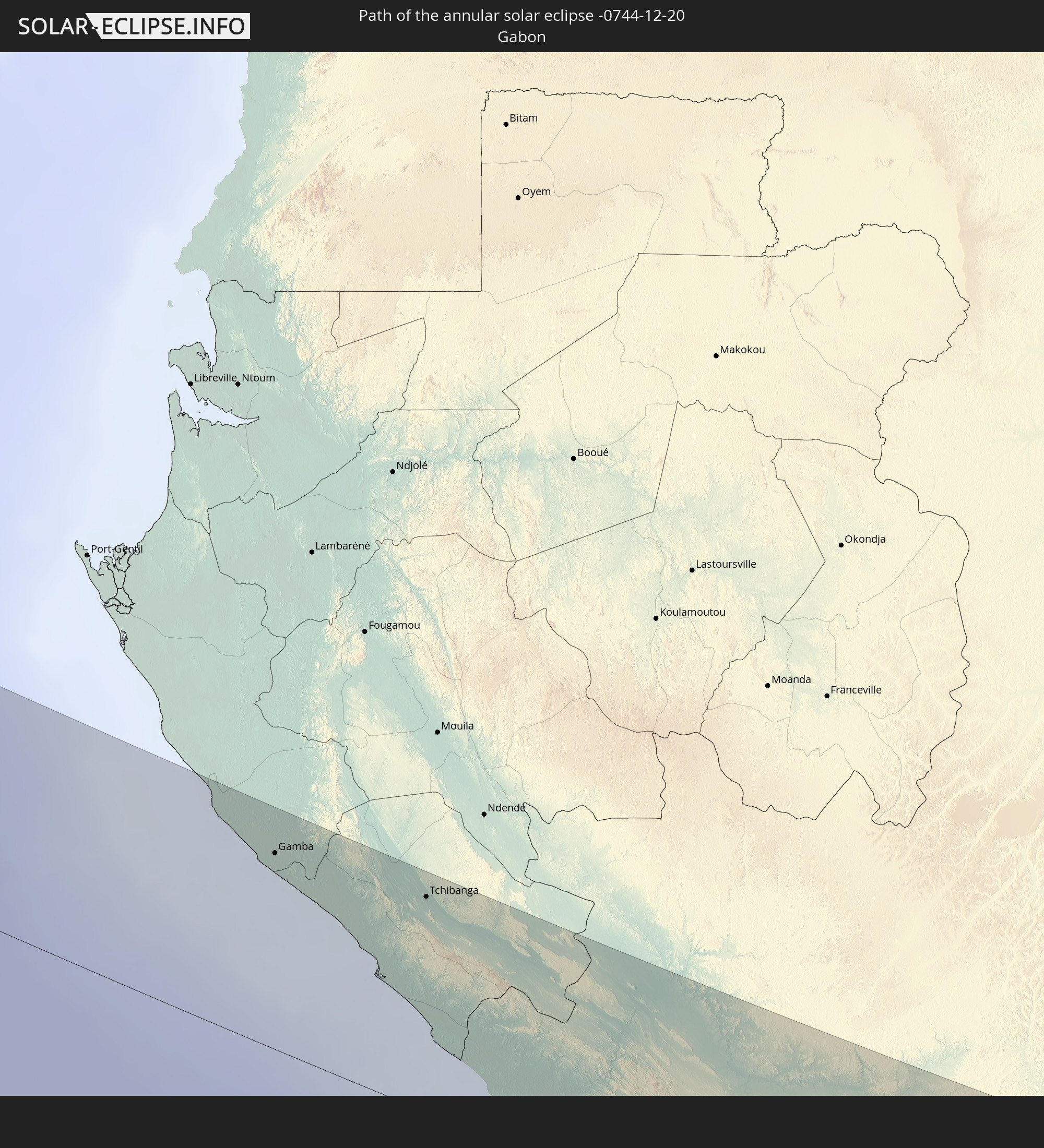 Gabon
Gabon
 Republic of the Congo
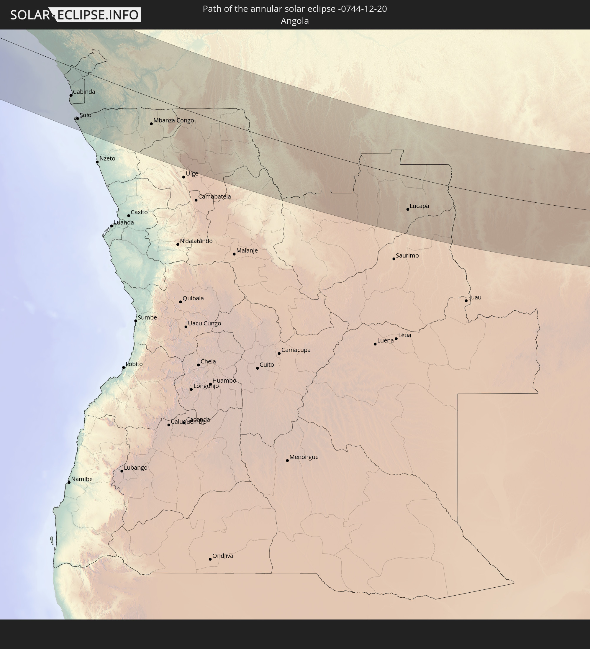 Angola
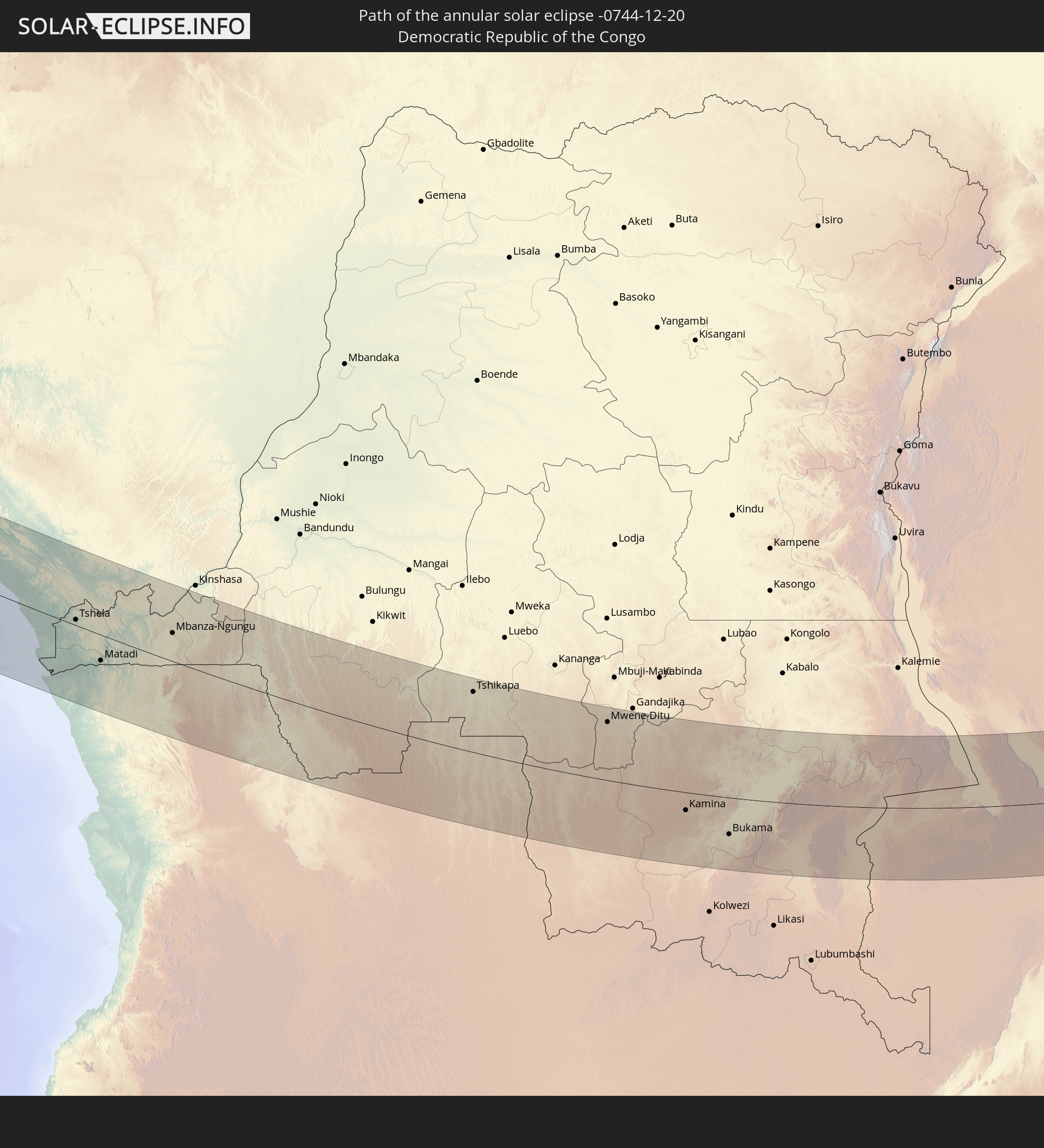 Democratic Republic of the Congo
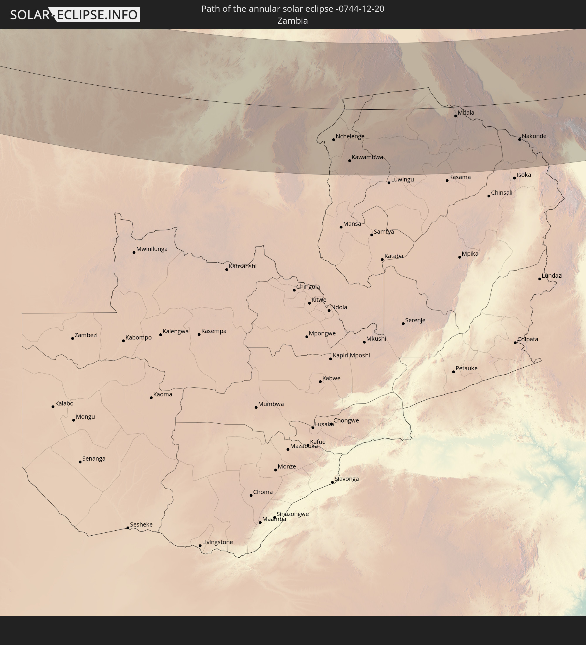 Zambia
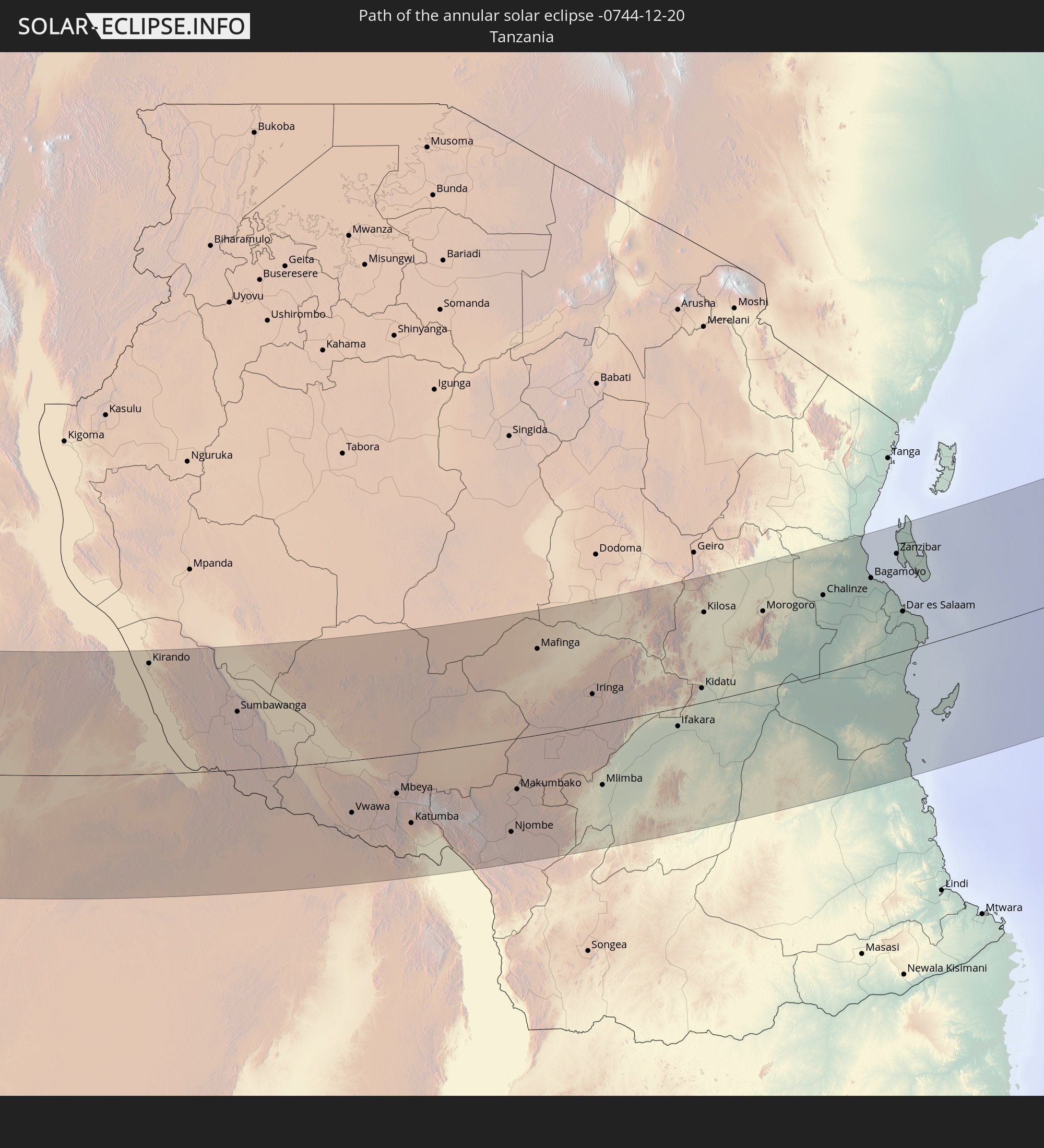 Tanzania
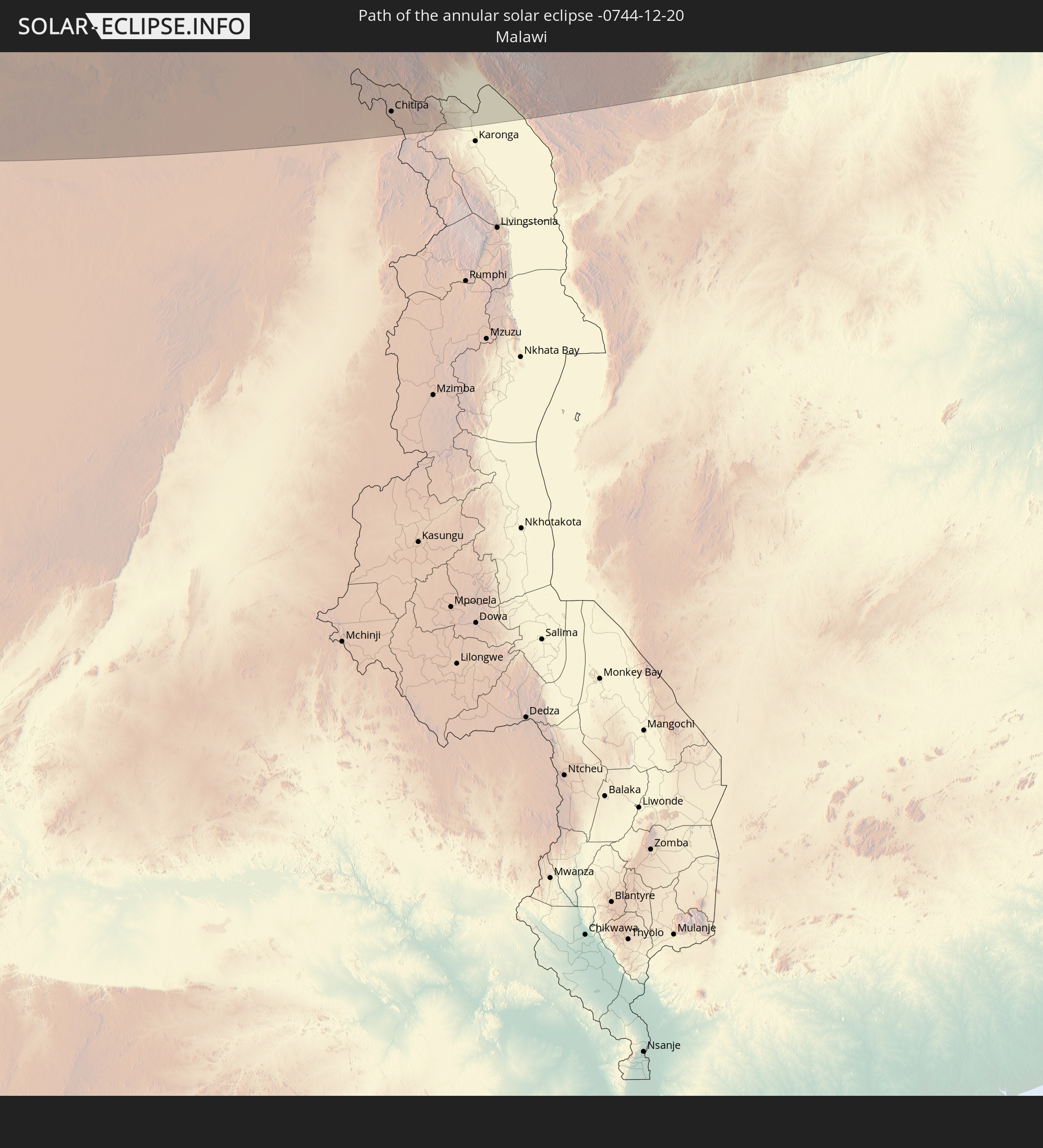 Malawi
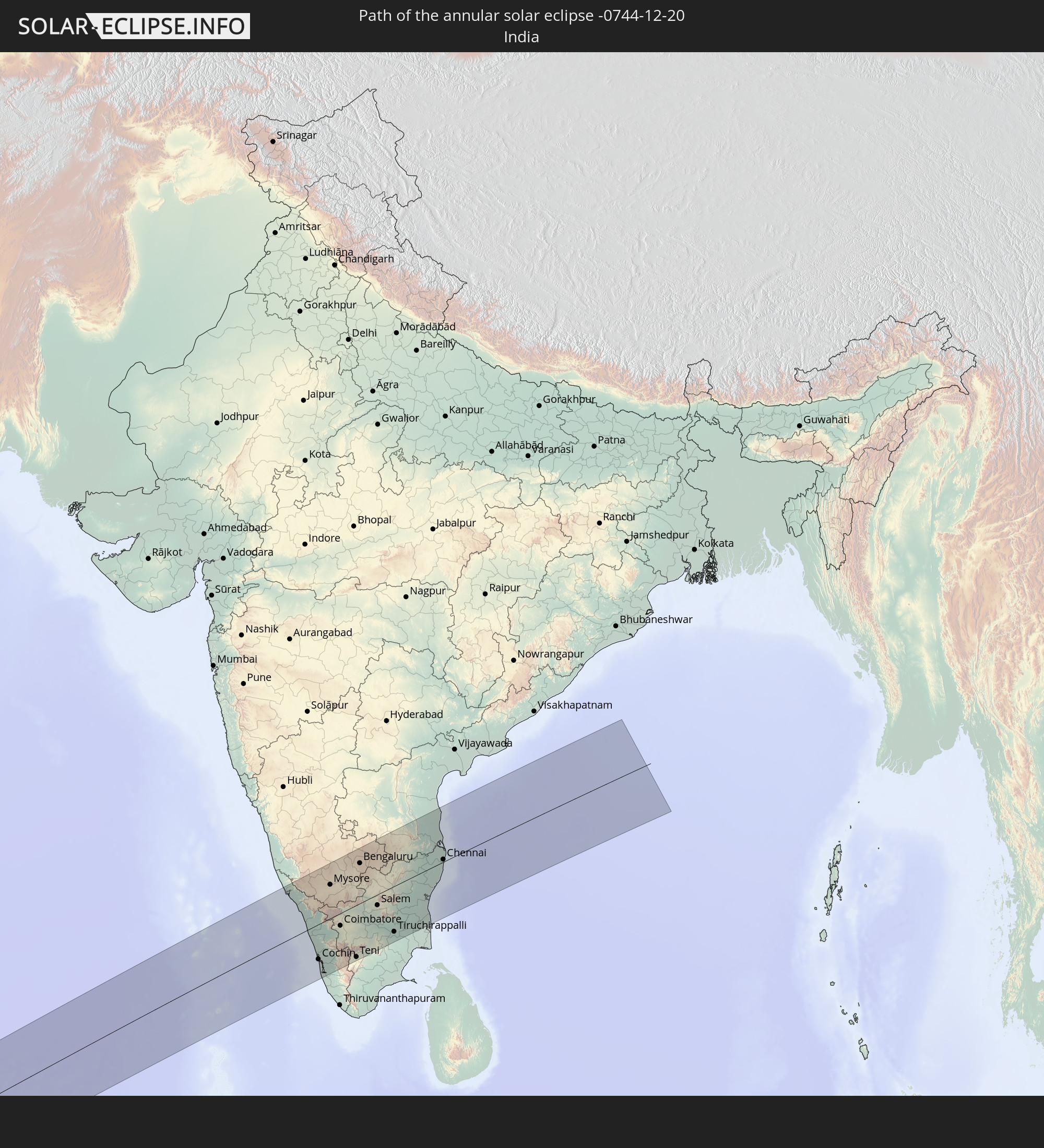 India
India
In den folgenden Ländern ist die Sonnenfinsternis partiell zu sehen
 Brazil
 Portugal
 Spain
Spain
 Senegal
 Mauritania
 The Gambia
 Guinea-Bissau
 Guinea
 Saint Helena, Ascension and Tristan da Cunha
 Sierra Leone
 Morocco
 Mali
Mali
 Liberia
 Algeria
 Ivory Coast
 Burkina Faso
 Gibraltar
 France
 Ghana
Ghana
 Togo
Togo
 Niger
Niger
 Benin
Benin
 Nigeria
 Equatorial Guinea
 São Tomé and Príncipe
 Italy
Italy
 Tunisia
 Cameroon
 Gabon
Gabon
 Libya
Libya
 Republic of the Congo
 Angola
 Namibia
 Democratic Republic of the Congo
 Chad
Chad
 Malta
Malta
 Central African Republic
 South Africa
 Botswana
 Sudan
Sudan
 Zambia
 Egypt
Egypt
 Zimbabwe
 Turkey
 Lesotho
 Rwanda
 Burundi
 Tanzania
 Uganda
 Mozambique
 Swaziland
 Malawi
 Ethiopia
 Kenya
Kenya
 State of Palestine
 Israel
 Saudi Arabia
 Jordan
 Lebanon
 Syria
Syria
 Eritrea
 Iraq
Iraq
 French Southern and Antarctic Lands
 Somalia
 Djibouti
 Yemen
Yemen
 Madagascar
 Comoros
 Iran
Iran
 Azerbaijan
 Mayotte
 Seychelles
 Kazakhstan
 Kuwait
 Bahrain
 Qatar
Qatar
 United Arab Emirates
 Oman
Oman
 Turkmenistan
 Réunion
 Uzbekistan
 Mauritius
 Afghanistan
 Pakistan
 Tajikistan
 India
India
 Kyrgyzstan
 British Indian Ocean Territory
 Maldives
 China
China
 Sri Lanka
 Nepal
Nepal
 Cocos Islands
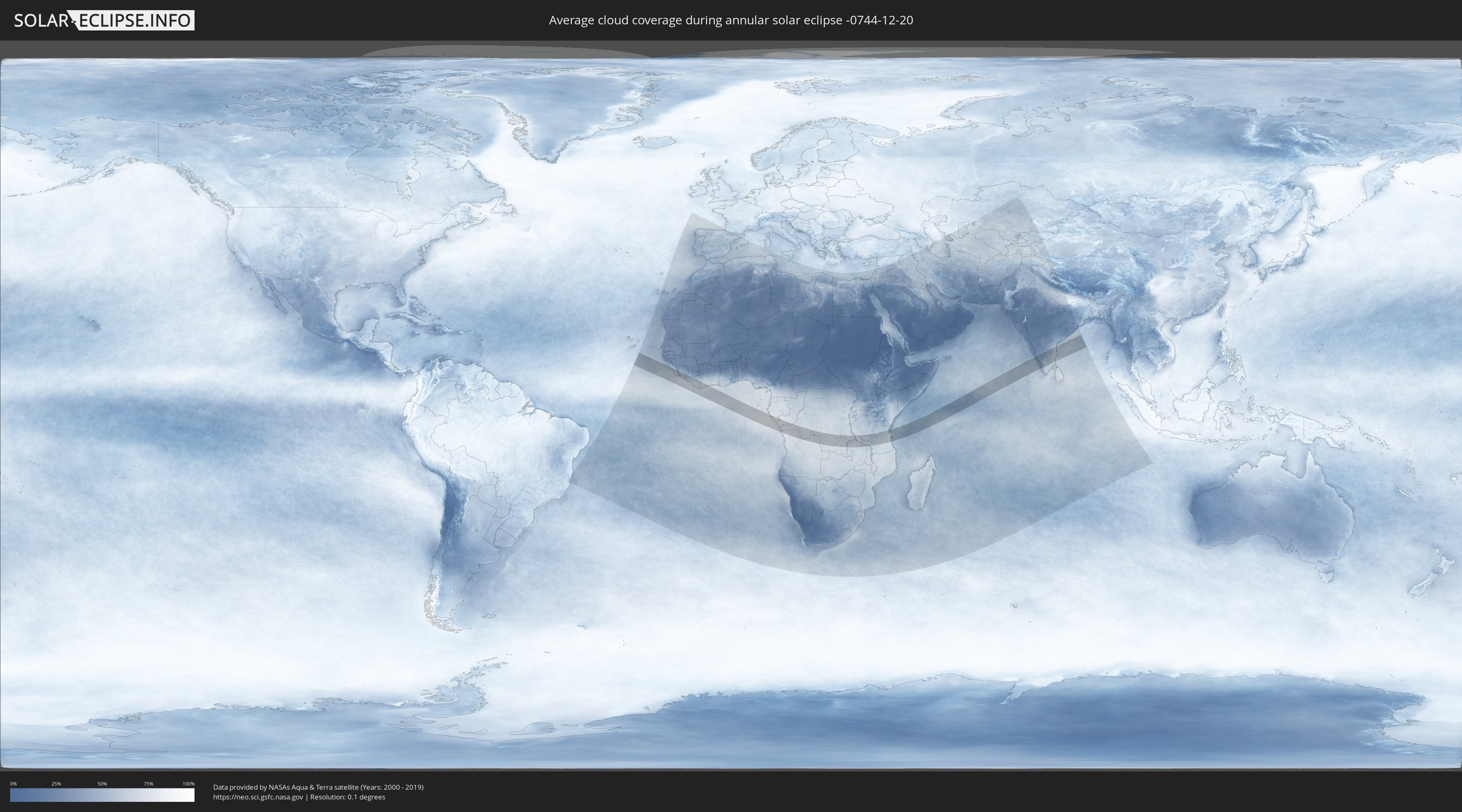
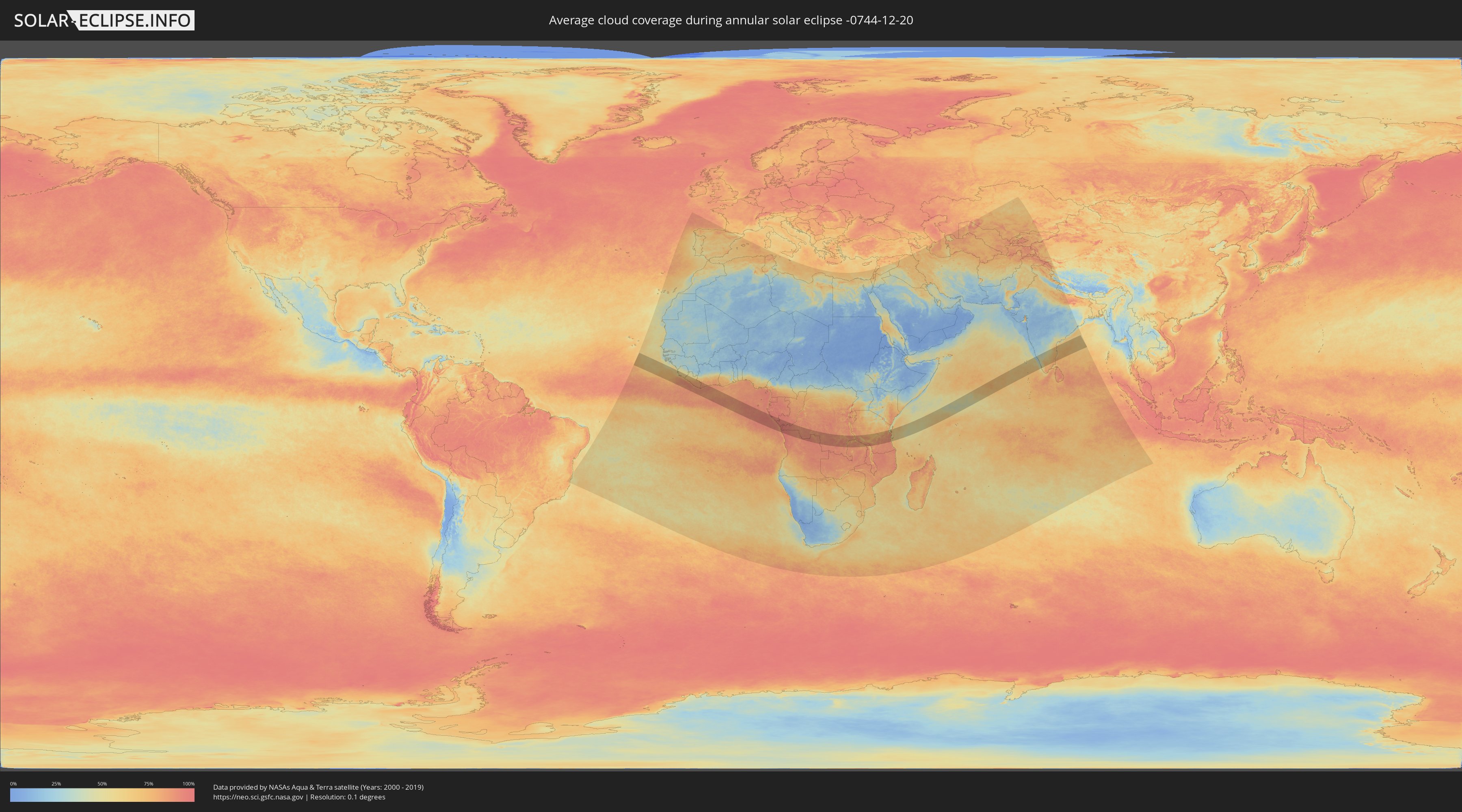
How will be the weather during the annular solar eclipse on 12/20/-0744?
Where is the best place to see the annular solar eclipse of 12/20/-0744?
The following maps show the average cloud coverage for the day of the annular solar eclipse.
With the help of these maps, it is possible to find the place along the eclipse path, which has the best
chance of a cloudless sky.
Nevertheless, you should consider local circumstances and inform about the weather of your chosen
observation site.
The data is provided by NASAs satellites
AQUA and TERRA.
The cloud maps are averaged over a period of 19 years (2000 - 2019).
Detailed country maps
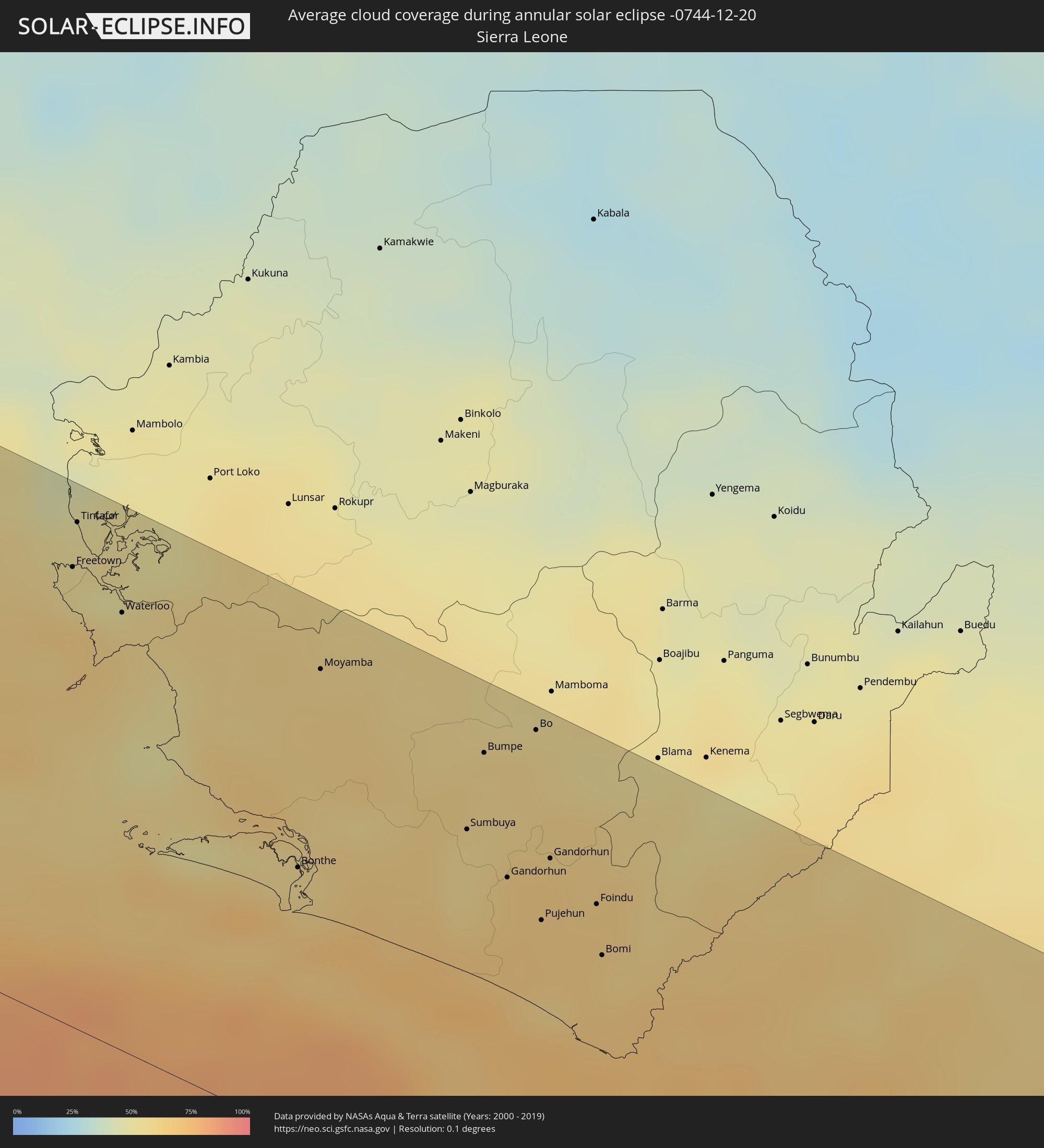 Sierra Leone
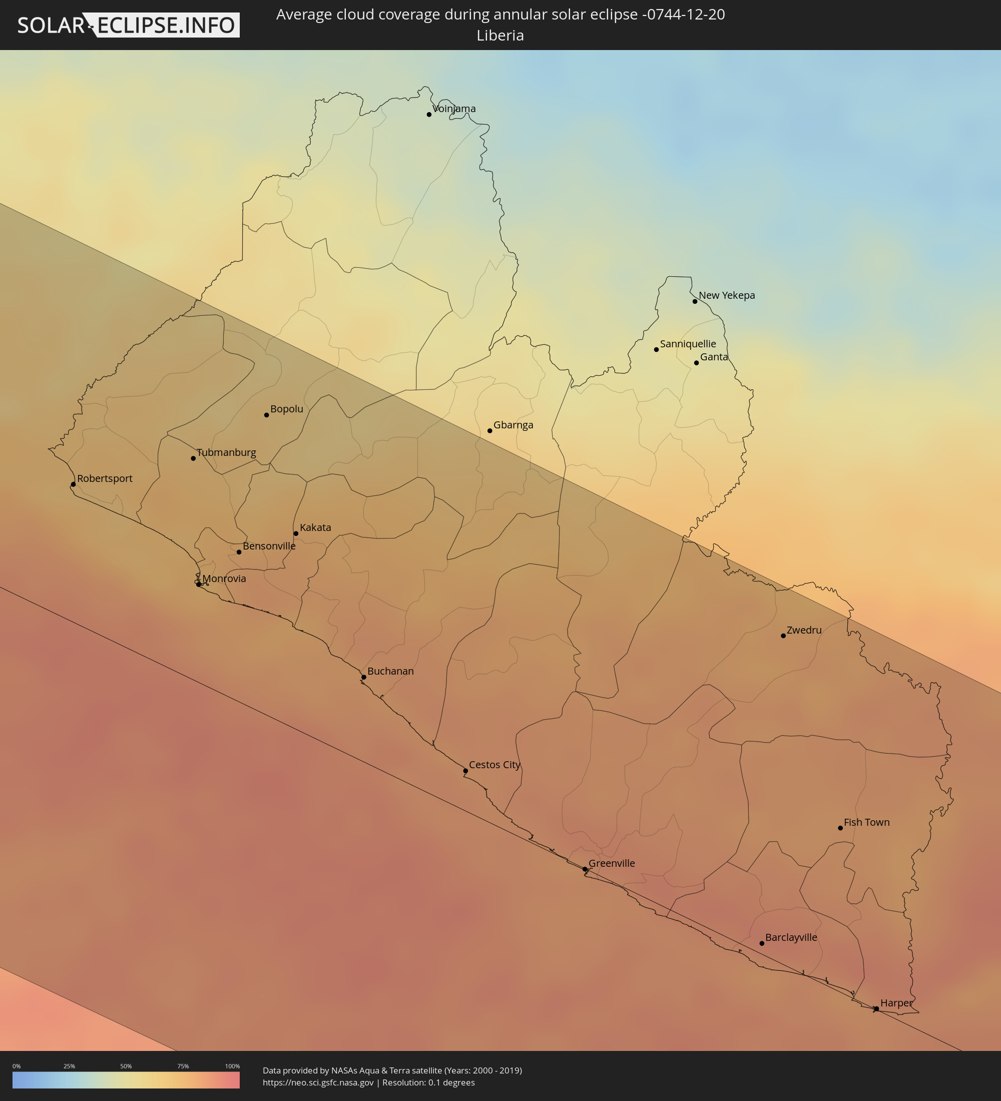 Liberia
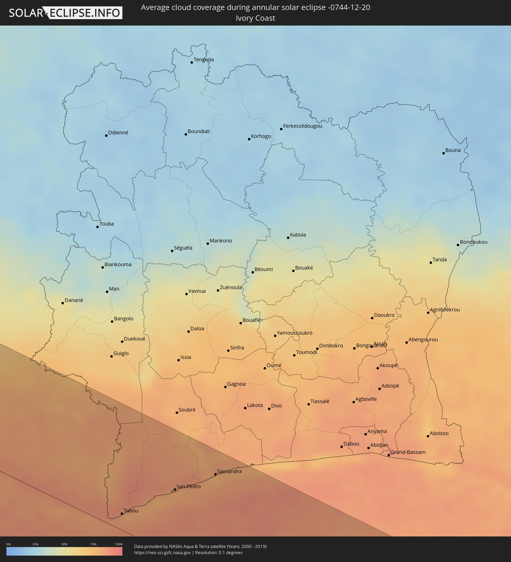 Ivory Coast
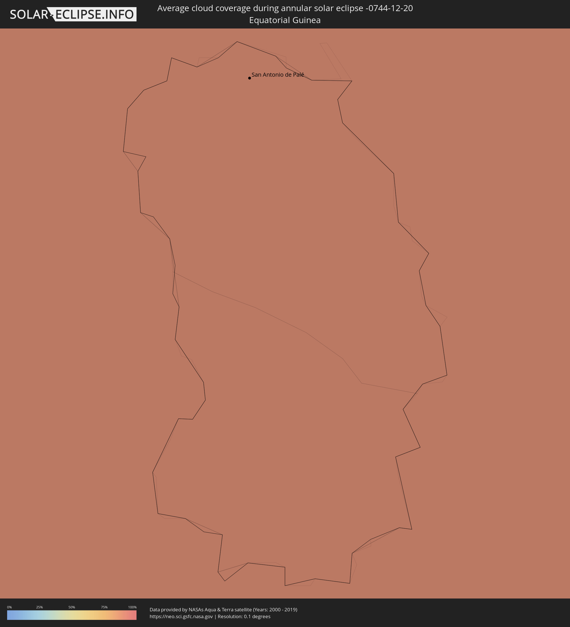 Equatorial Guinea
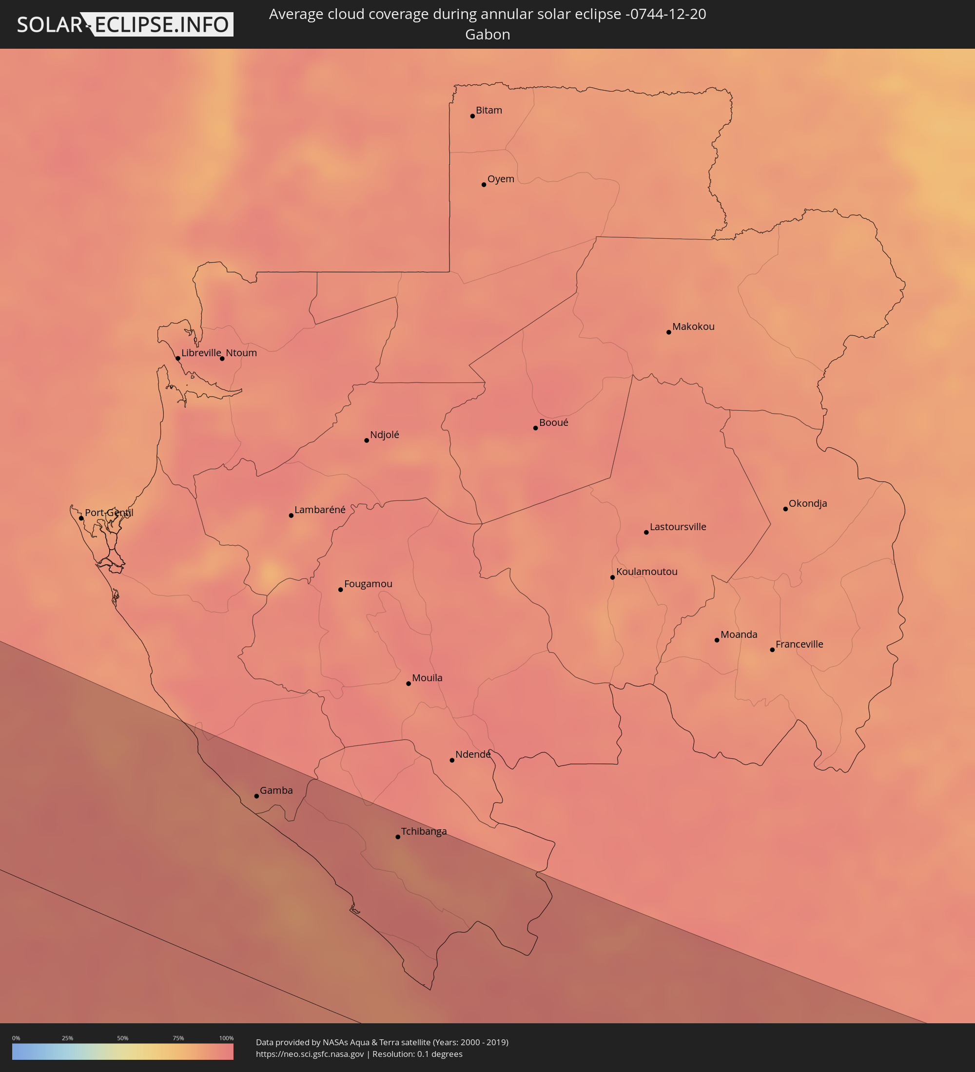 Gabon
Gabon
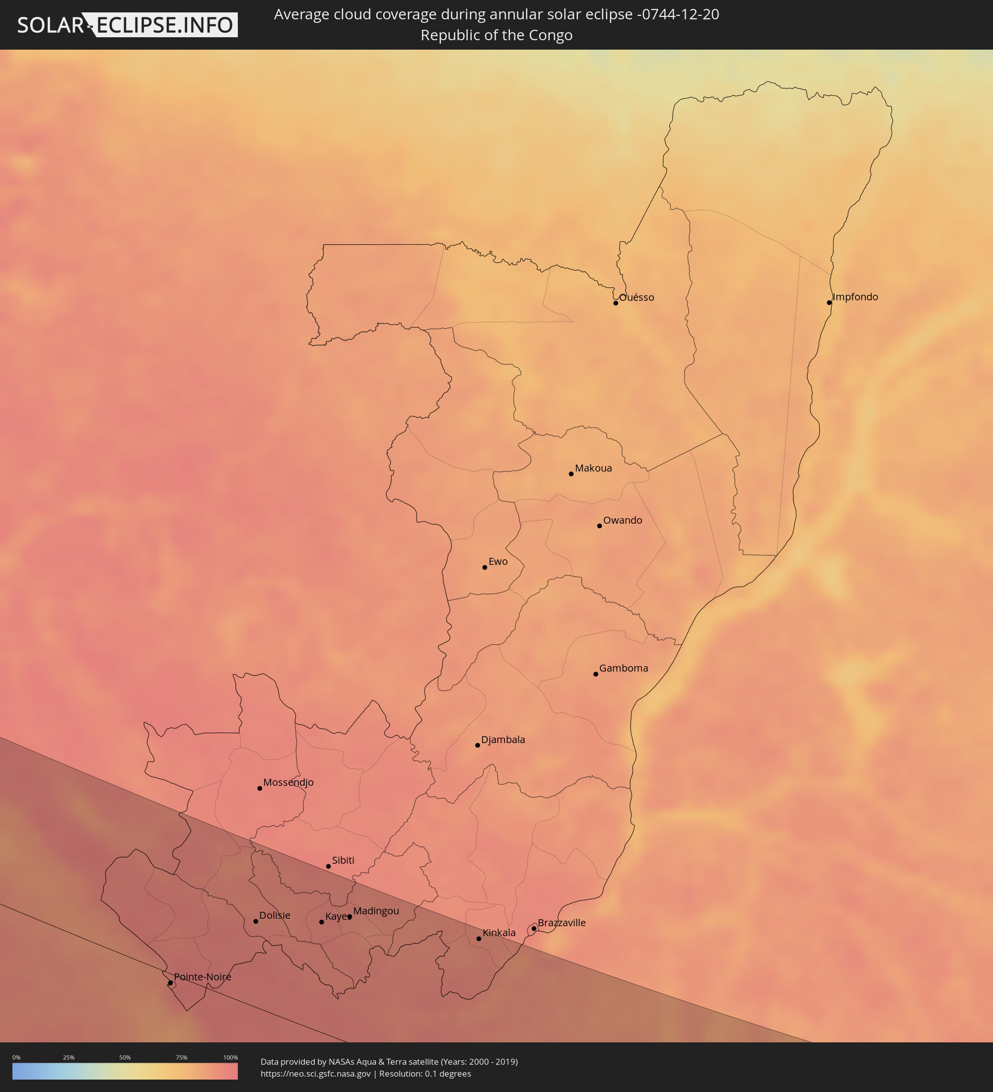 Republic of the Congo
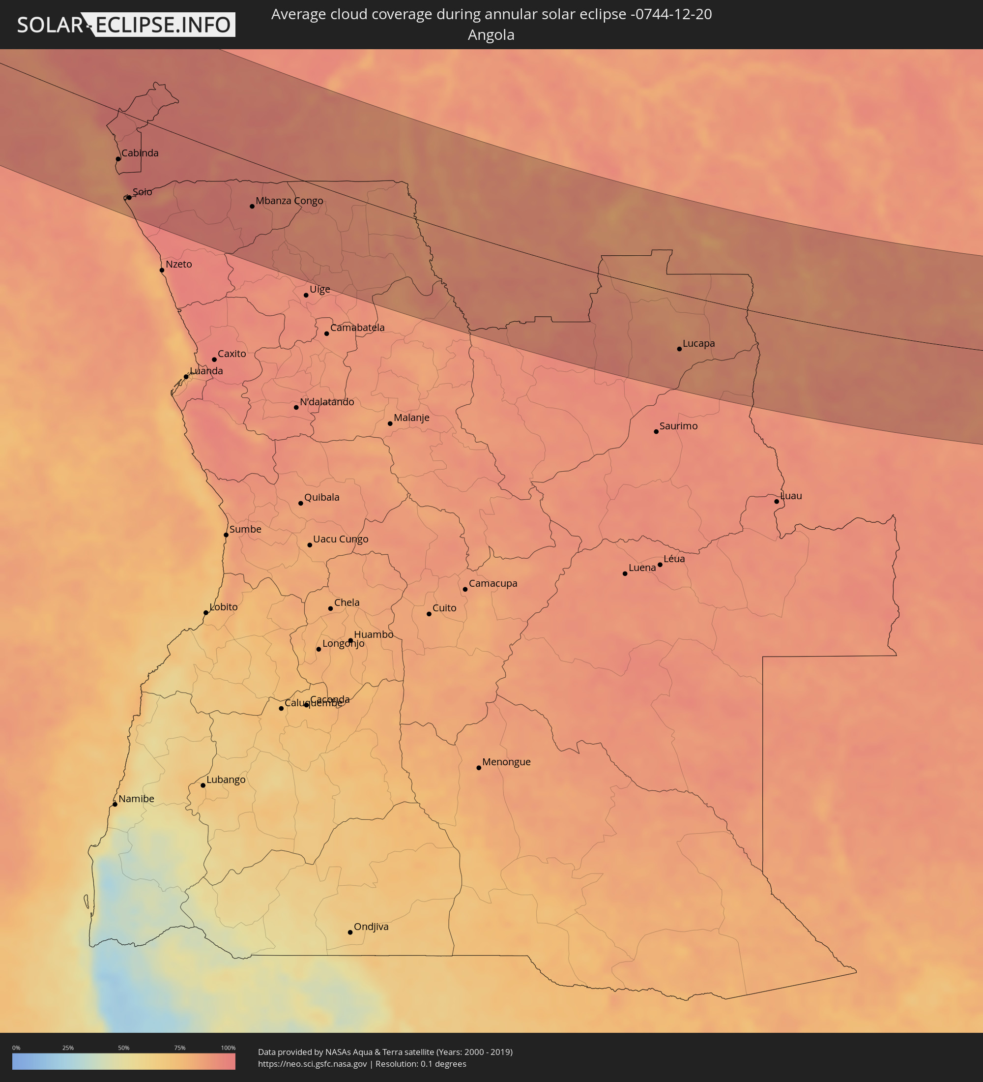 Angola
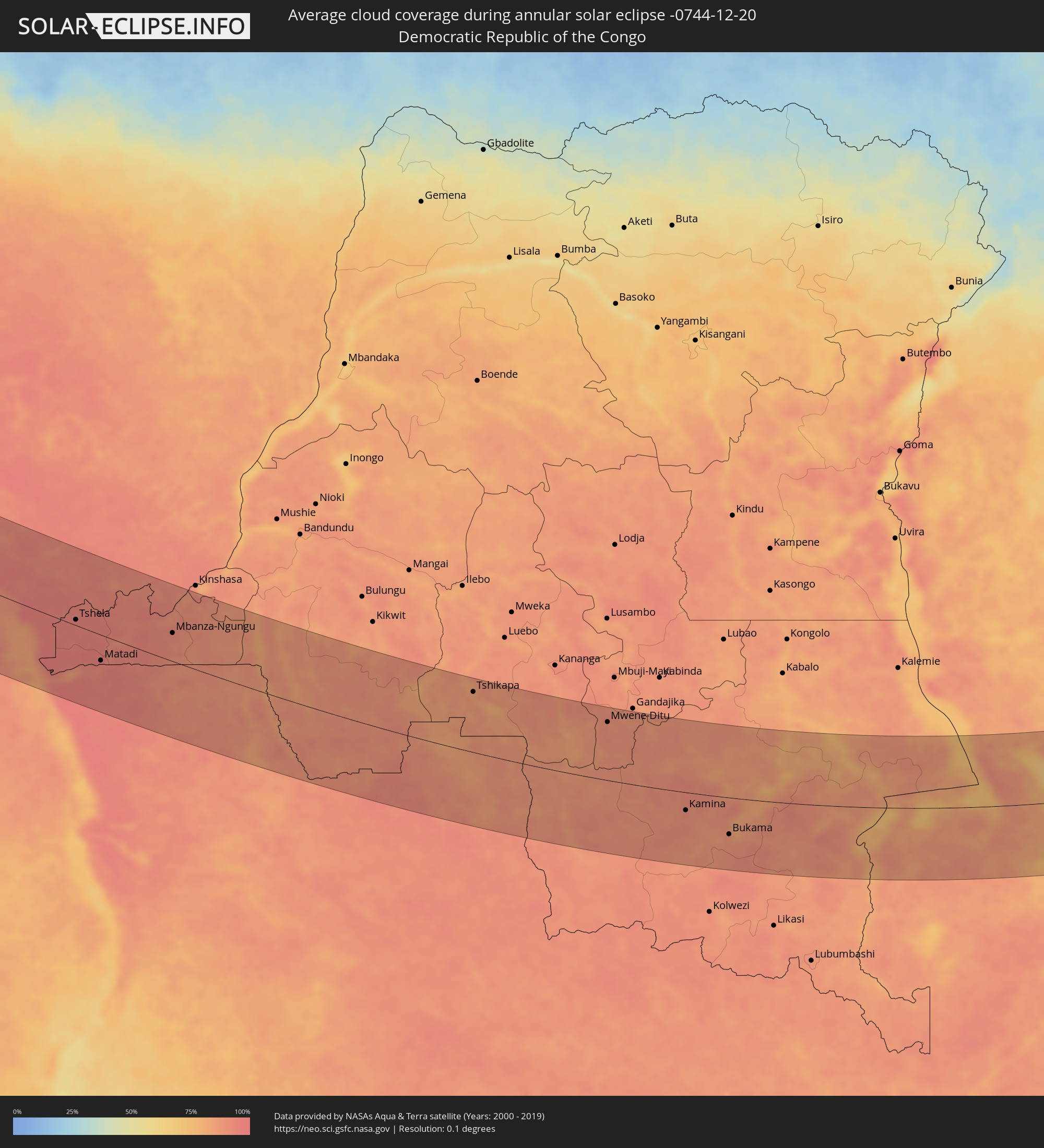 Democratic Republic of the Congo
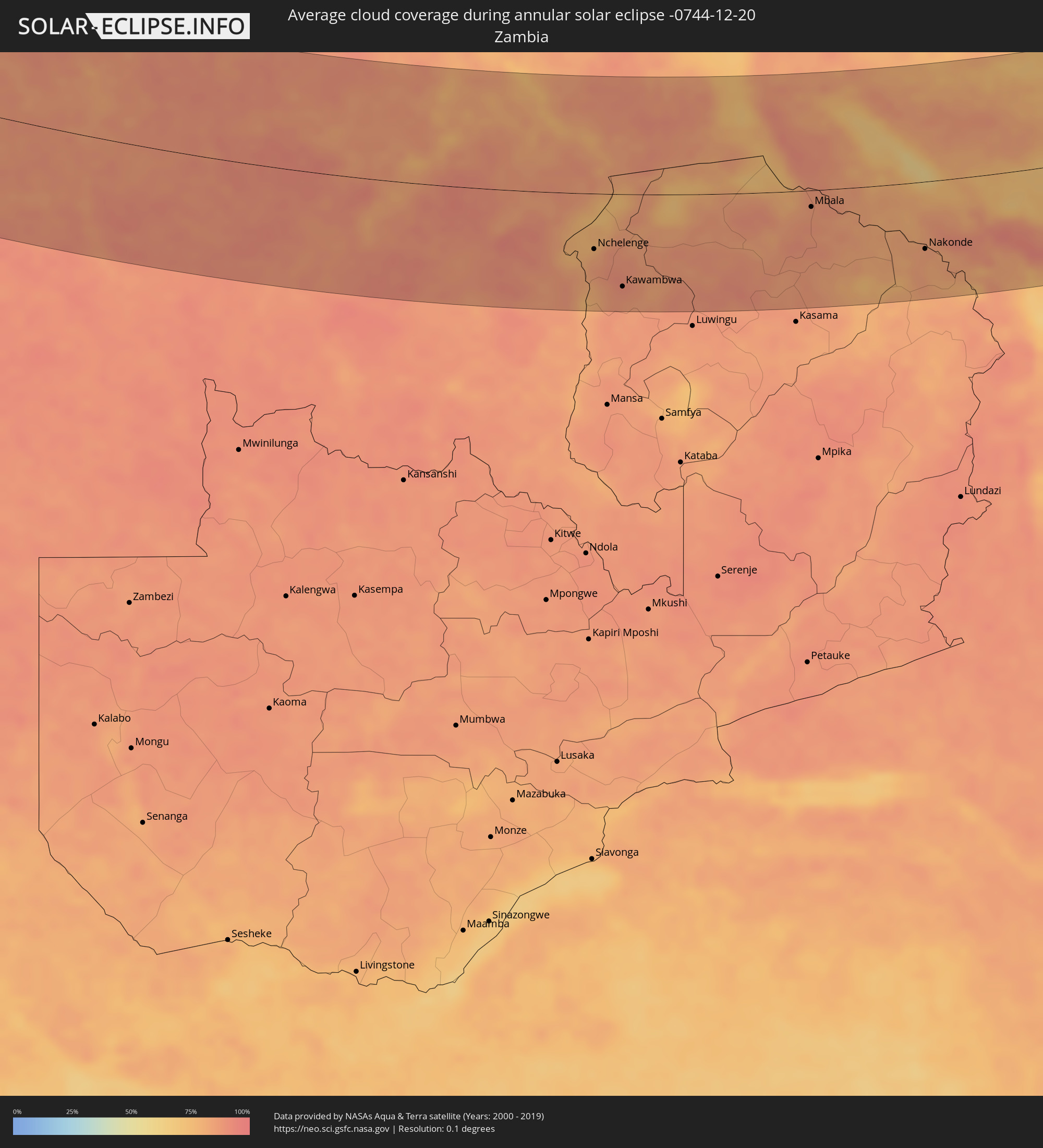 Zambia
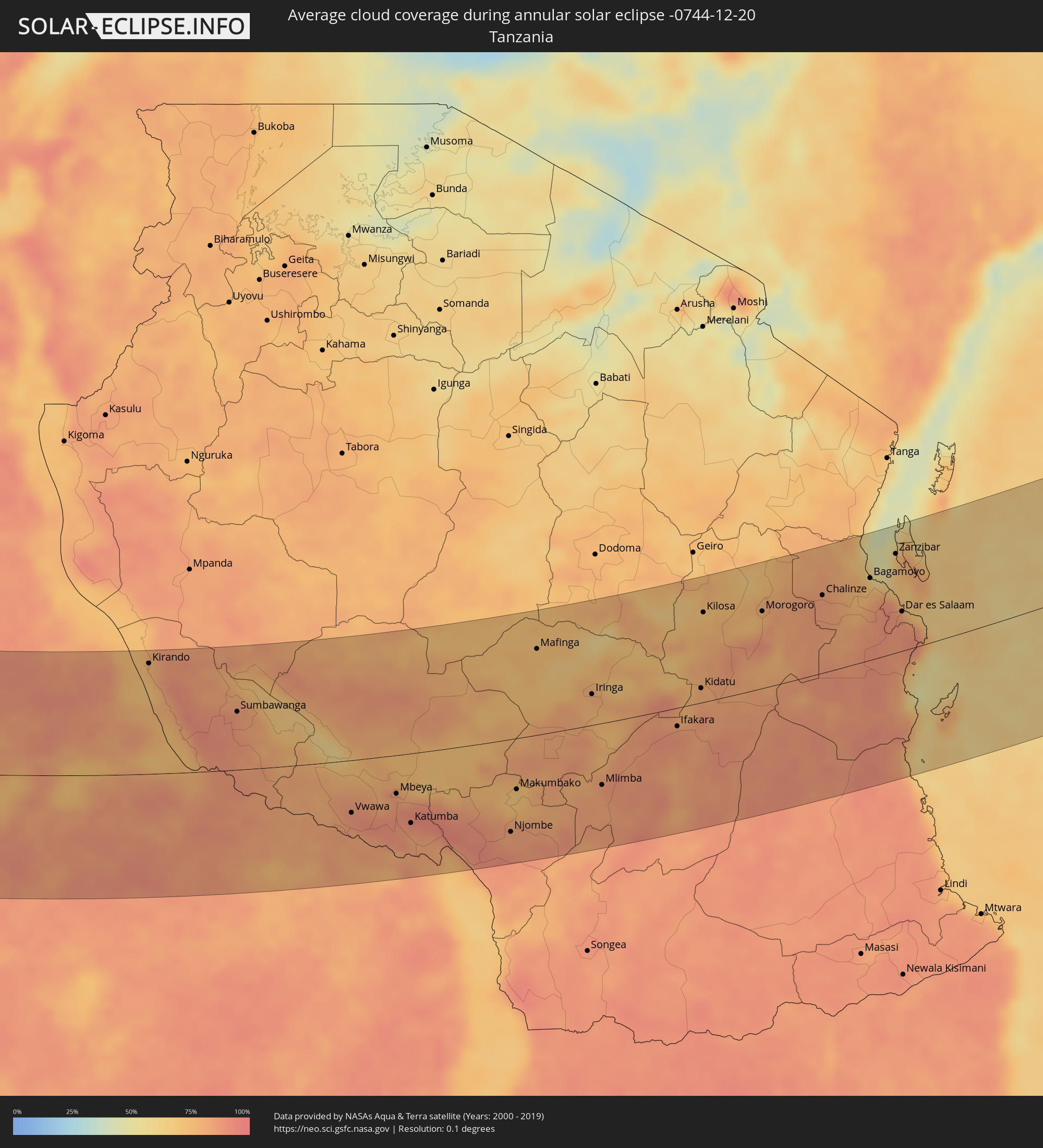 Tanzania
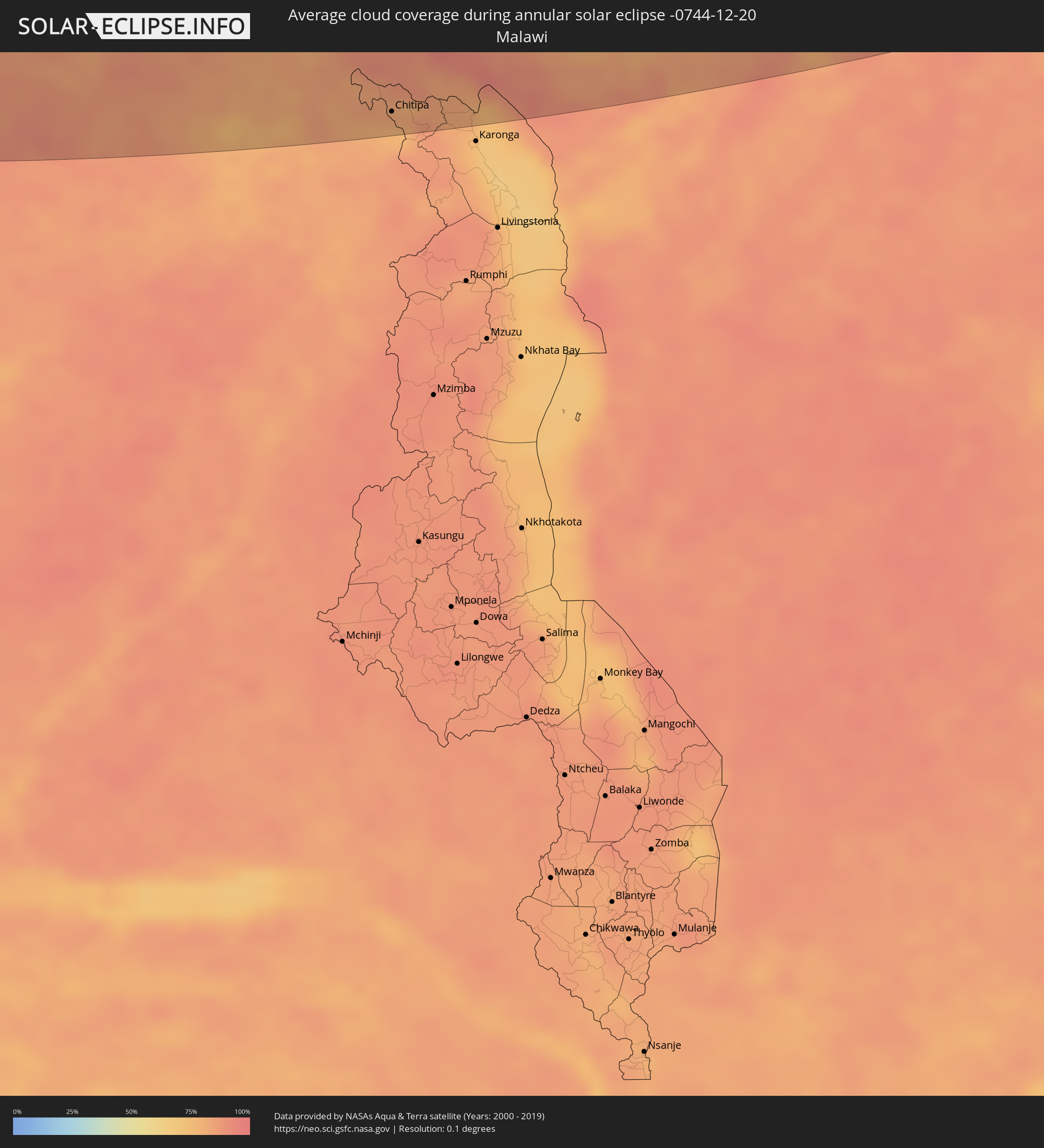 Malawi
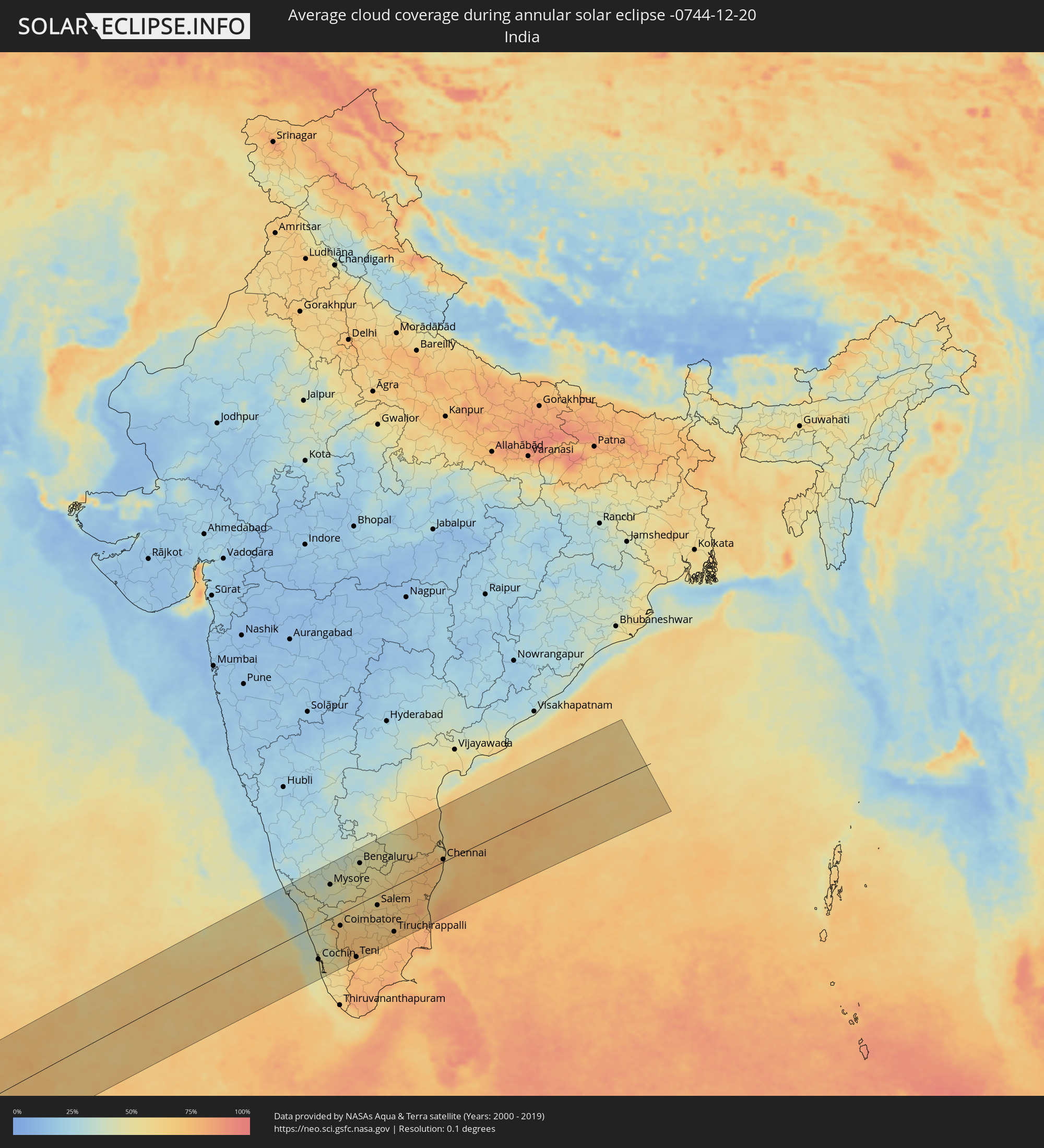 India
India
Cities inside the path of the eclipse
The following table shows all locations with a population of more than 5,000 inside the eclipse path. Cities which have more than 100,000 inhabitants are marked bold. A click at the locations opens a detailed map.
| City | Type | Eclipse duration | Local time of max. eclipse | Distance to central line | Ø Cloud coverage |
|
Freetown, Western Area
|
annular | - | 07:41:40 UTC-00:16 | 139 km | 64% |
|
Freetown, Western Area
|
annular | - | 07:41:42 UTC-00:16 | 147 km | 53% |
|
Tintafor, Northern Province
|
annular | - | 07:41:42 UTC-00:16 | 163 km | 53% |
|
Hastings, Western Area
|
annular | - | 07:41:45 UTC-00:16 | 141 km | 59% |
|
Waterloo, Western Area
|
annular | - | 07:41:47 UTC-00:16 | 140 km | 62% |
|
Bonthe, Southern Province
|
annular | - | 07:42:07 UTC-00:16 | 86 km | 61% |
|
Moyamba, Southern Province
|
annular | - | 07:42:06 UTC-00:16 | 153 km | 60% |
|
Sumbuya, Southern Province
|
annular | - | 07:42:23 UTC-00:16 | 124 km | 56% |
|
Bumpe, Southern Province
|
annular | - | 07:42:24 UTC-00:16 | 151 km | 59% |
|
Gandorhun, Southern Province
|
annular | - | 07:42:28 UTC-00:16 | 115 km | 65% |
|
Bo, Southern Province
|
annular | - | 07:42:29 UTC-00:16 | 166 km | 56% |
|
Pujehun, Southern Province
|
annular | - | 07:42:33 UTC-00:16 | 106 km | 65% |
|
Baoma, Southern Province
|
annular | - | 07:42:30 UTC-00:16 | 170 km | 56% |
|
Gandorhun, Southern Province
|
annular | - | 07:42:32 UTC-00:16 | 127 km | 65% |
|
Foindu, Southern Province
|
annular | - | 07:42:38 UTC-00:16 | 120 km | 63% |
|
Bomi, Southern Province
|
annular | - | 07:42:40 UTC-00:16 | 104 km | 65% |
|
Robertsport, Grand Cape Mount
|
annular | - | 07:15:48 UTC-00:43 | 62 km | 68% |
|
Tubmanburg, Bomi
|
annular | - | 07:16:07 UTC-00:43 | 100 km | 69% |
|
Monrovia, Montserrado
|
annular | - | 07:16:12 UTC-00:43 | 44 km | 75% |
|
Bensonville, Montserrado
|
annular | - | 07:16:17 UTC-00:43 | 68 km | 81% |
|
Bopolu, Gbarpolu
|
annular | - | 07:16:17 UTC-00:43 | 136 km | 64% |
|
Kakata, Margibi
|
annular | - | 07:16:26 UTC-00:43 | 89 km | 79% |
|
Buchanan, Grand Bassa
|
annular | - | 07:16:44 UTC-00:43 | 38 km | 80% |
|
Cestos City, River Cess
|
annular | - | 07:17:07 UTC-00:43 | 18 km | 81% |
|
Greenville, Sinoe
|
annular | - | 07:17:34 UTC-00:43 | 1 km | 83% |
|
Barclayville, Grand Kru
|
annular | - | 07:18:13 UTC-00:43 | 5 km | 88% |
|
Zwedru, Grand Gedeh
|
annular | - | 07:18:01 UTC-00:43 | 149 km | 79% |
|
Fish Town, River Gee
|
annular | - | 07:18:23 UTC-00:43 | 74 km | 81% |
|
Harper, Maryland
|
annular | - | 07:18:41 UTC-00:43 | 0 km | 83% |
|
Tabou, Bas-Sassandra
|
annular | - | 07:45:58 UTC-00:16 | 22 km | 84% |
|
San-Pédro, Bas-Sassandra
|
annular | - | 07:46:28 UTC-00:16 | 89 km | 83% |
|
Sassandra, Bas-Sassandra
|
annular | - | 07:46:54 UTC-00:16 | 137 km | 76% |
|
San Antonio de Palé, Annobón Province
|
annular | - | 08:34:26 UTC+00:13 | 60 km | 91% |
|
Gamba, Ogooué-Maritime
|
annular | - | 08:44:02 UTC+00:13 | 130 km | 90% |
|
Tchibanga, Nyanga
|
annular | - | 08:46:29 UTC+00:13 | 144 km | 86% |
|
Loango, Kouilou
|
annular | - | 08:49:34 UTC+00:13 | 1 km | 92% |
|
Loandjili, Pointe-Noire
|
annular | - | 08:49:45 UTC+00:13 | 8 km | 95% |
|
Pointe-Noire, Pointe-Noire
|
annular | - | 08:49:47 UTC+00:13 | 10 km | 95% |
|
Cabinda, Cabinda
|
annular | - | 08:51:07 UTC+00:13 | 76 km | 93% |
|
Soio, Zaire
|
annular | - | 08:51:57 UTC+00:13 | 130 km | 92% |
|
Dolisie, Niari
|
annular | - | 08:51:26 UTC+00:13 | 83 km | 93% |
|
Tshela, Bas-Congo
|
annular | - | 08:52:40 UTC+00:13 | 12 km | 95% |
|
Kayes, Bouenza
|
annular | - | 08:53:03 UTC+00:13 | 107 km | 95% |
|
Matadi, Bas-Congo
|
annular | - | 08:54:29 UTC+00:13 | 53 km | 92% |
|
Madingou, Bouenza
|
annular | - | 08:53:44 UTC+00:13 | 123 km | 91% |
|
Mbanza Congo, Zaire
|
annular | - | 08:56:57 UTC+00:13 | 71 km | 94% |
|
Kinkala, Pool
|
annular | - | 08:57:12 UTC+00:13 | 149 km | 92% |
|
Mbanza-Ngungu, Bas-Congo
|
annular | - | 08:58:01 UTC+00:13 | 58 km | 91% |
|
Kasangulu, Bas-Congo
|
annular | - | 08:58:29 UTC+00:13 | 141 km | 92% |
|
Kasongo-Lunda, Bandundu
|
annular | - | 09:04:32 UTC+00:13 | 0 km | 85% |
|
Lucapa, Luanda Norte
|
annular | - | 09:18:27 UTC+00:13 | 90 km | 89% |
|
Tshikapa, Kasaï-Occidental
|
annular | - | 11:14:25 UTC+02:10 | 128 km | 84% |
|
Mwene-Ditu, Kasaï-Oriental
|
annular | - | 11:24:30 UTC+02:10 | 125 km | 88% |
|
Kamina, Katanga
|
annular | - | 11:31:00 UTC+02:10 | 39 km | 91% |
|
Bukama, Katanga
|
annular | - | 11:34:27 UTC+02:10 | 79 km | 87% |
|
Nchelenge, Luapula
|
annular | - | 11:46:01 UTC+02:10 | 74 km | 79% |
|
Kawambwa, Luapula
|
annular | - | 11:47:25 UTC+02:10 | 123 km | 88% |
|
Mpulungu, Northern
|
annular | - | 11:55:57 UTC+02:10 | 12 km | 81% |
|
Mbala, Northern
|
annular | - | 11:56:59 UTC+02:10 | 22 km | 86% |
|
Sumbawanga, Rukwa
|
annular | - | 12:15:13 UTC+02:27 | 73 km | 86% |
|
Nakonde, Muchinga Province
|
annular | - | 12:02:33 UTC+02:10 | 89 km | 83% |
|
Tunduma, Mbeya
|
annular | - | 12:19:35 UTC+02:27 | 85 km | 85% |
|
Vwawa, Mbeya
|
annular | - | 12:20:20 UTC+02:27 | 66 km | 88% |
|
Chitipa, Northern Region
|
annular | - | 12:04:33 UTC+02:10 | 135 km | 77% |
|
Mbeya, Mbeya
|
annular | - | 12:22:34 UTC+02:27 | 48 km | 83% |
|
Katumba, Mbeya
|
annular | - | 12:23:06 UTC+02:27 | 87 km | 88% |
|
Njombe, Njombe
|
annular | - | 12:27:44 UTC+02:27 | 116 km | 84% |
|
Makumbako, Njombe
|
annular | - | 12:28:16 UTC+02:27 | 64 km | 71% |
|
Mafinga, Iringa
|
annular | - | 12:30:06 UTC+02:27 | 108 km | 72% |
|
Iringa, Iringa
|
annular | - | 12:32:25 UTC+02:27 | 39 km | 78% |
|
Mlimba, Morogoro
|
annular | - | 12:32:16 UTC+02:27 | 77 km | 85% |
|
Ifakara, Morogoro
|
annular | - | 12:36:10 UTC+02:27 | 23 km | 86% |
|
Kidatu, Morogoro
|
annular | - | 12:37:33 UTC+02:27 | 18 km | 79% |
|
Kilosa, Morogoro
|
annular | - | 12:38:15 UTC+02:27 | 111 km | 73% |
|
Morogoro, Morogoro
|
annular | - | 12:40:59 UTC+02:27 | 95 km | 79% |
|
Bagamoyo, Pwani
|
annular | - | 12:46:10 UTC+02:27 | 100 km | 66% |
|
Zanzibar, Zanzibar Urban/West
|
annular | - | 12:47:32 UTC+02:27 | 121 km | 75% |
|
Dar es Salaam, Dar es Salaam
|
annular | - | 12:47:16 UTC+02:27 | 48 km | 80% |
|
Kozhikode, Kerala
|
annular | - | 17:03:05 UTC+05:21 | 43 km | 39% |
|
Trichūr, Kerala
|
annular | - | 17:03:11 UTC+05:21 | 51 km | 43% |
|
Cochin, Kerala
|
annular | - | 17:03:06 UTC+05:21 | 110 km | 53% |
|
Mysore, Karnataka
|
annular | - | 17:03:37 UTC+05:21 | 105 km | 44% |
|
Coimbatore, Tamil Nadu
|
annular | - | 17:03:36 UTC+05:21 | 39 km | 66% |
|
Tiruppur, Tamil Nadu
|
annular | - | 17:03:48 UTC+05:21 | 48 km | 66% |
|
Teni, Tamil Nadu
|
annular | - | 17:03:40 UTC+05:21 | 163 km | 71% |
|
Bengaluru, Karnataka
|
annular | - | 17:04:05 UTC+05:21 | 125 km | 45% |
|
Dindigul, Tamil Nadu
|
annular | - | 17:03:56 UTC+05:21 | 153 km | 72% |
|
Salem, Tamil Nadu
|
annular | - | 17:04:11 UTC+05:21 | 34 km | 61% |
|
Tiruchirappalli, Tamil Nadu
|
annular | - | 17:04:17 UTC+05:21 | 143 km | 74% |
|
Thanjāvūr, Tamil Nadu
|
annular | - | 17:04:27 UTC+05:21 | 168 km | 75% |
|
Tirupati, Andhra Pradesh
|
annular | - | 17:04:46 UTC+05:21 | 103 km | 60% |
|
Puducherry, Pondicherry
|
annular | - | 17:04:49 UTC+05:21 | 87 km | 65% |
|
Nellore, Andhra Pradesh
|
annular | - | 17:04:57 UTC+05:21 | 157 km | 71% |
|
Āvadi, Tamil Nadu
|
annular | - | 17:04:59 UTC+05:21 | 18 km | 78% |
|
Chennai, Tamil Nadu
|
annular | - | 17:05:02 UTC+05:21 | 7 km | 65% |