Total solar eclipse of 09/06/-0794
| Day of week: | Monday |
| Maximum duration of eclipse: | 04m57s |
| Maximum width of eclipse path: | 188 km |
| Saros cycle: | 51 |
| Coverage: | 100% |
| Magnitude: | 1.0561 |
| Gamma: | 0.1718 |
Wo kann man die Sonnenfinsternis vom 09/06/-0794 sehen?
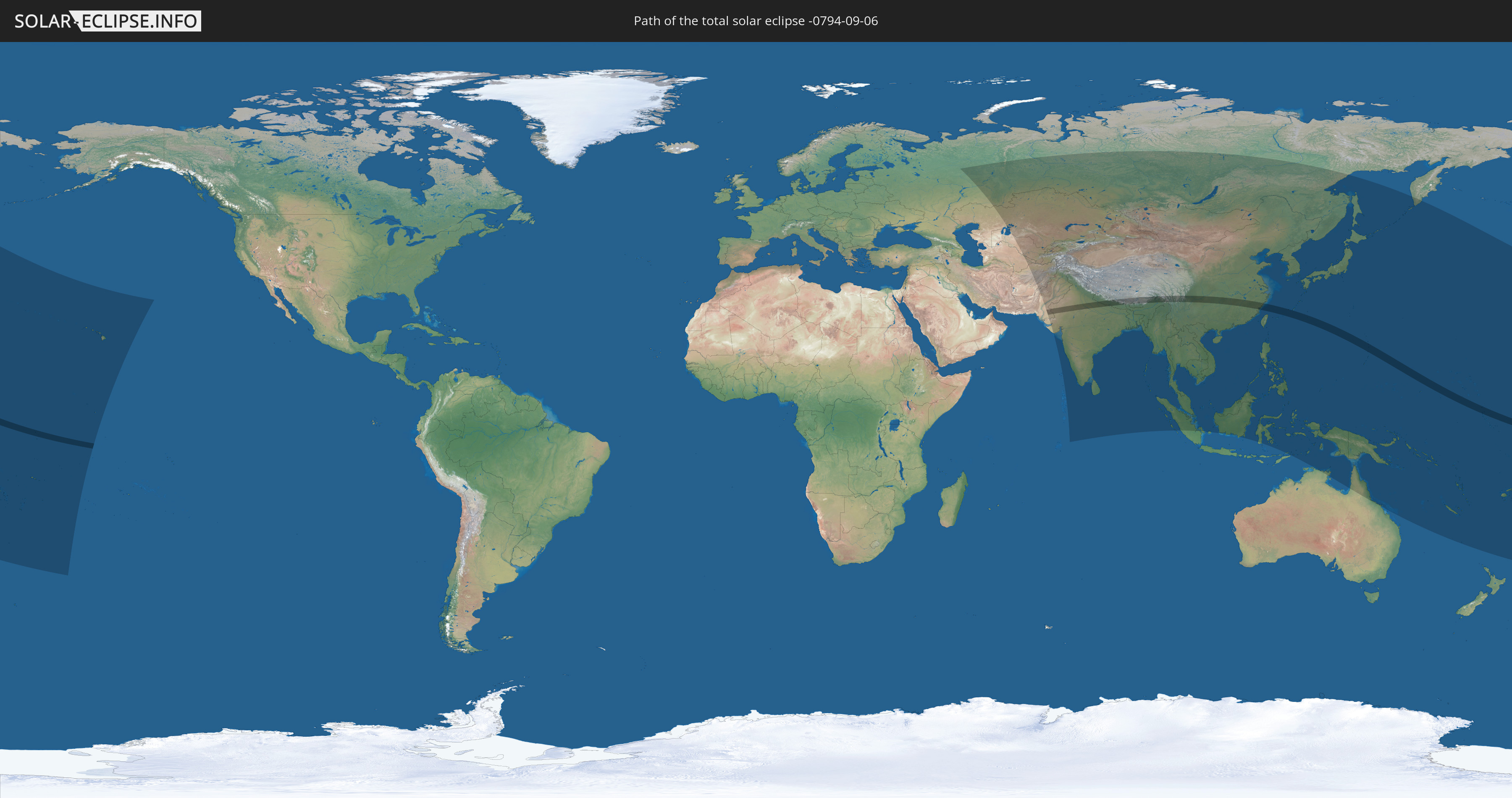
Die Sonnenfinsternis am 09/06/-0794 kann man in 56 Ländern als partielle Sonnenfinsternis beobachten.
Der Finsternispfad verläuft durch 11 Länder. Nur in diesen Ländern ist sie als total Sonnenfinsternis zu sehen.
In den folgenden Ländern ist die Sonnenfinsternis total zu sehen
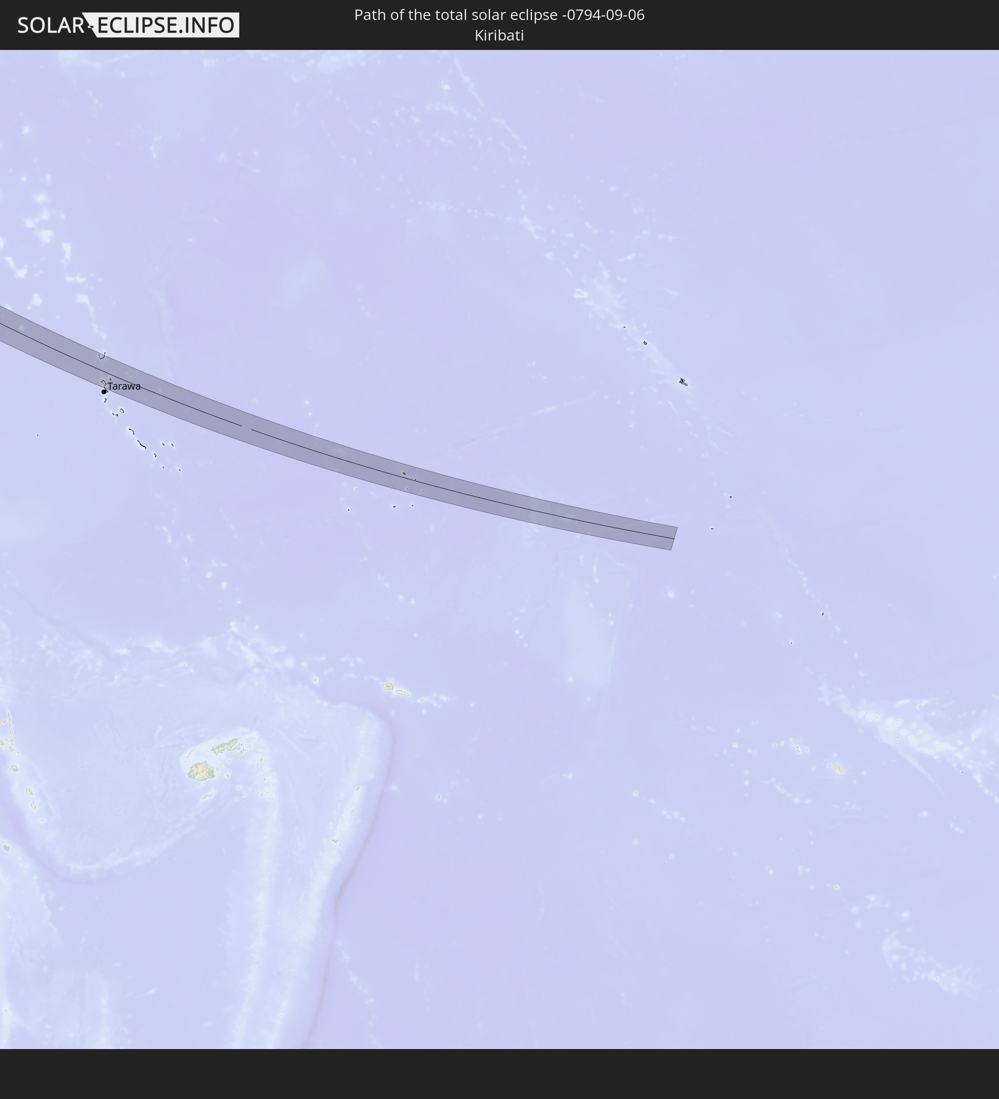 Kiribati
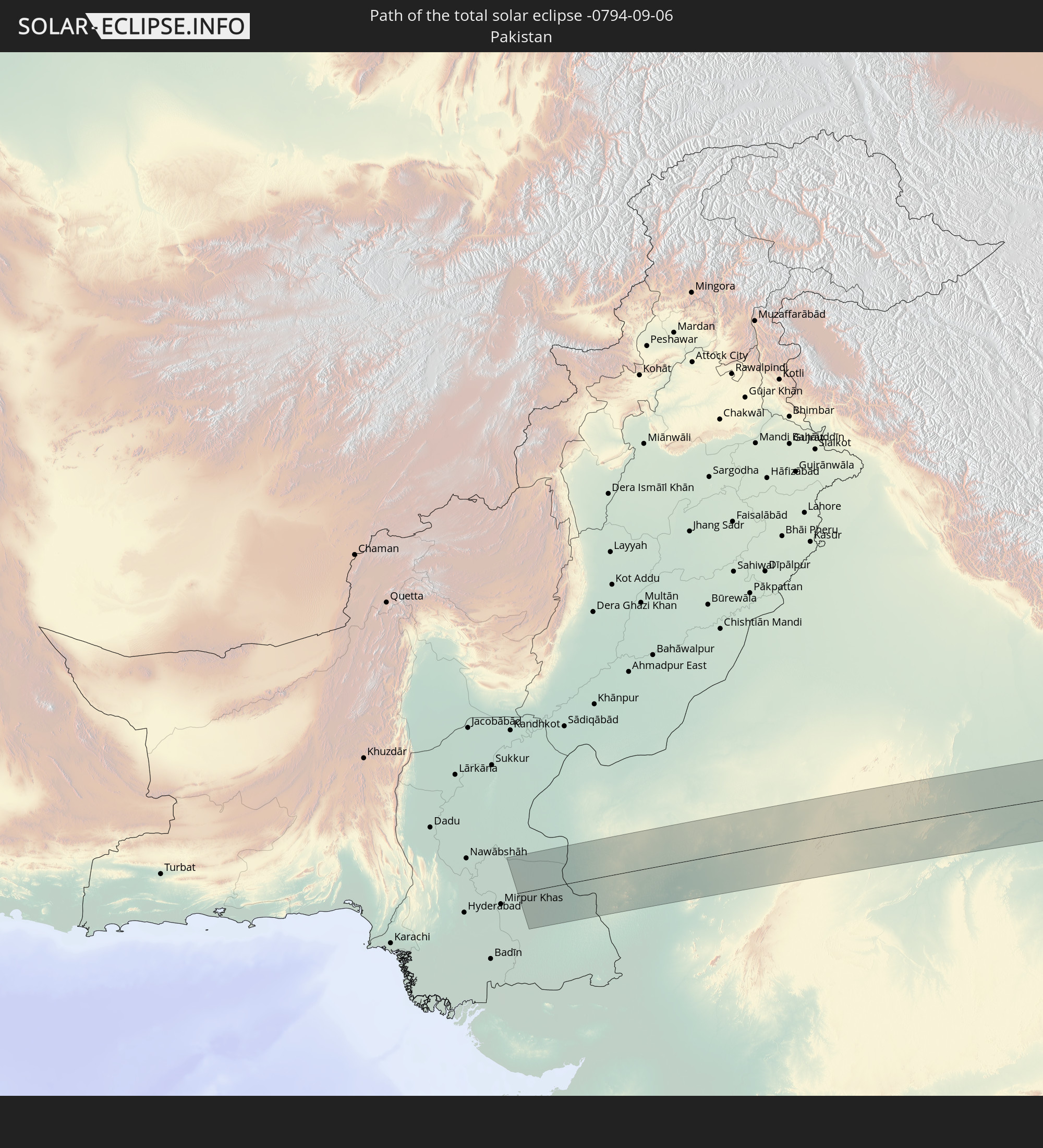 Pakistan
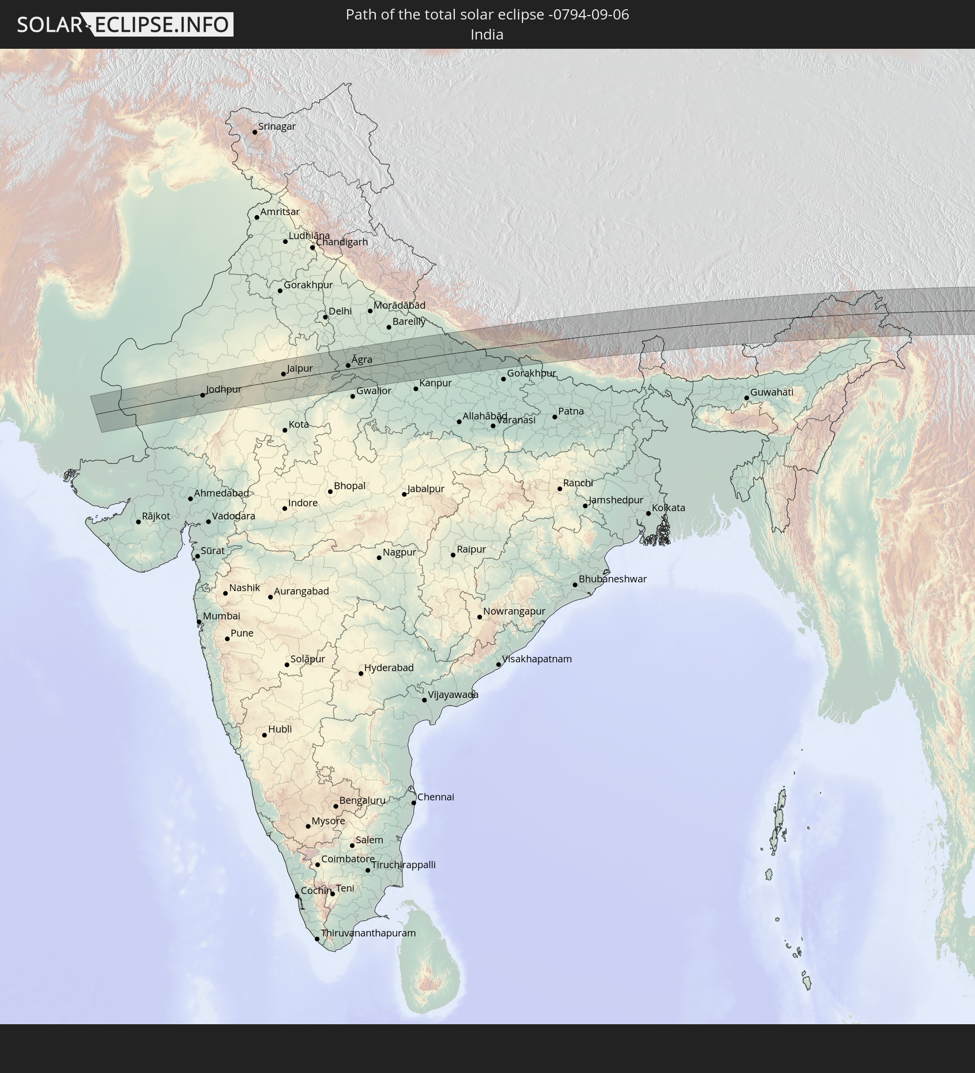 India
India
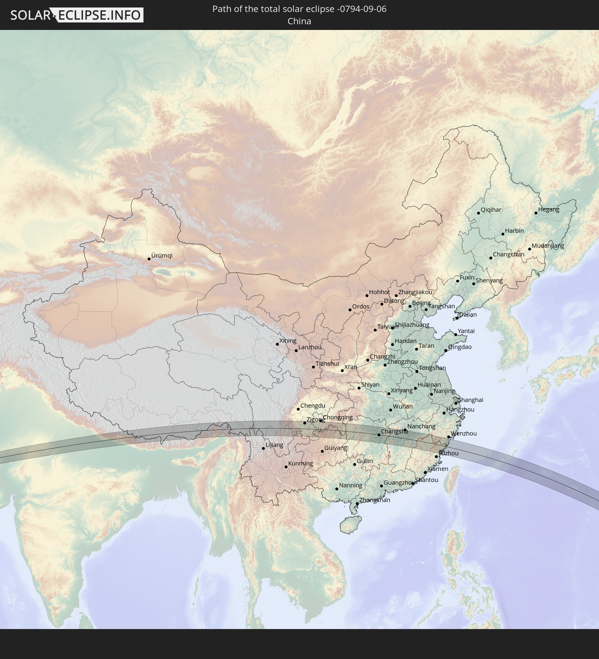 China
China
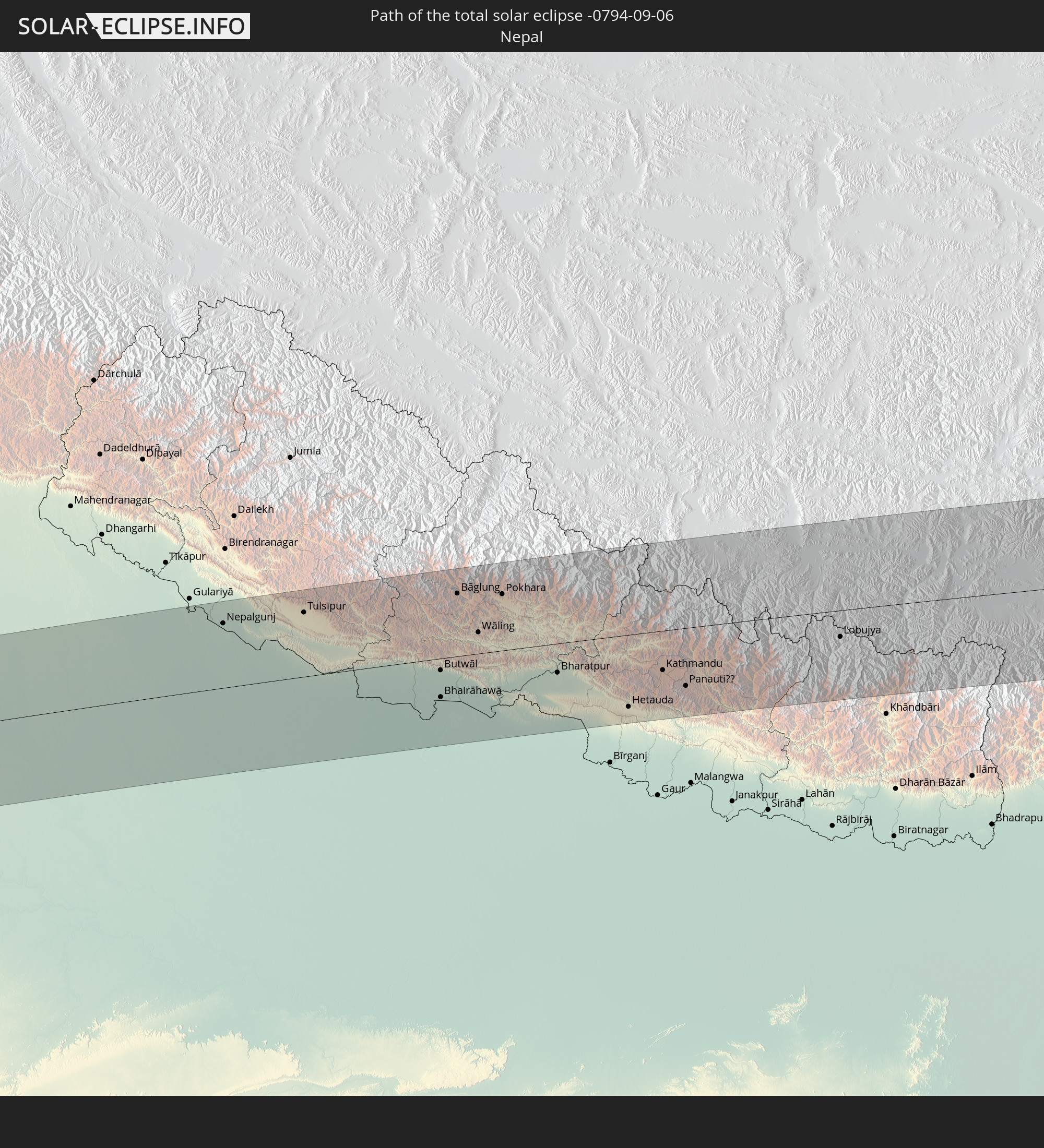 Nepal
Nepal
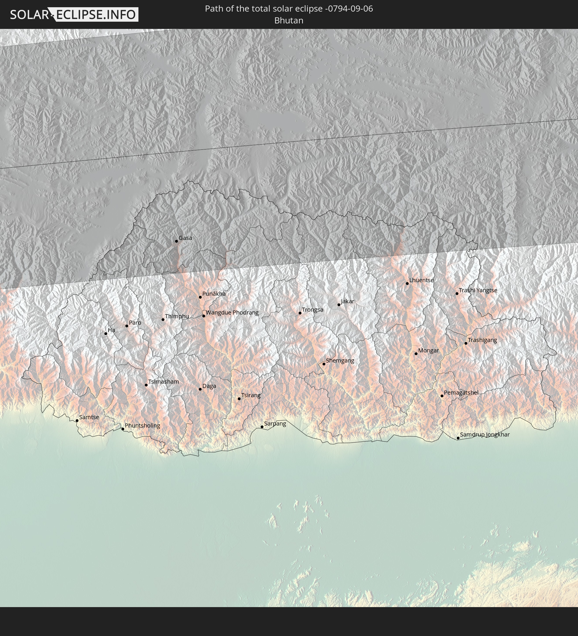 Bhutan
 Myanmar
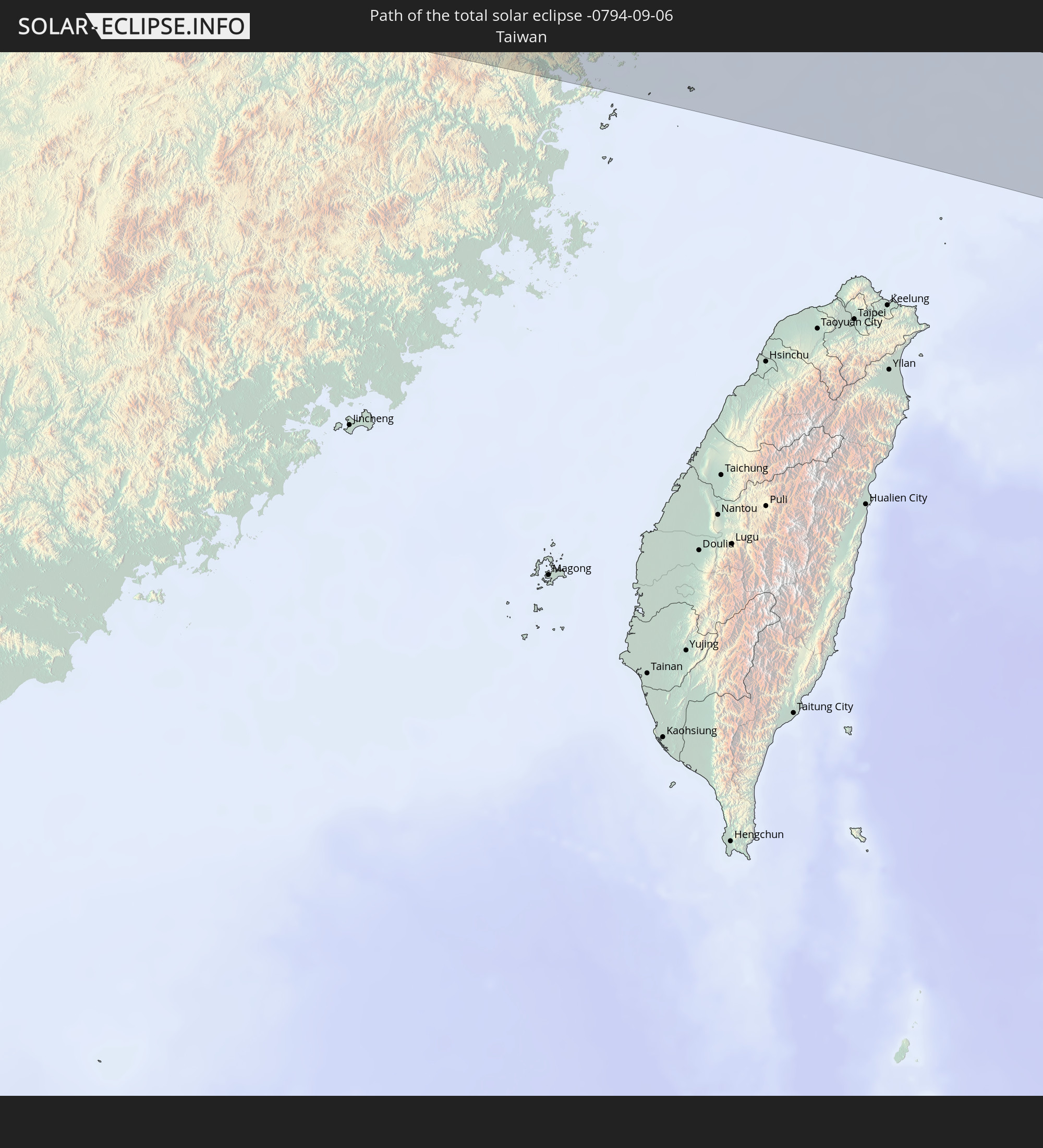 Taiwan
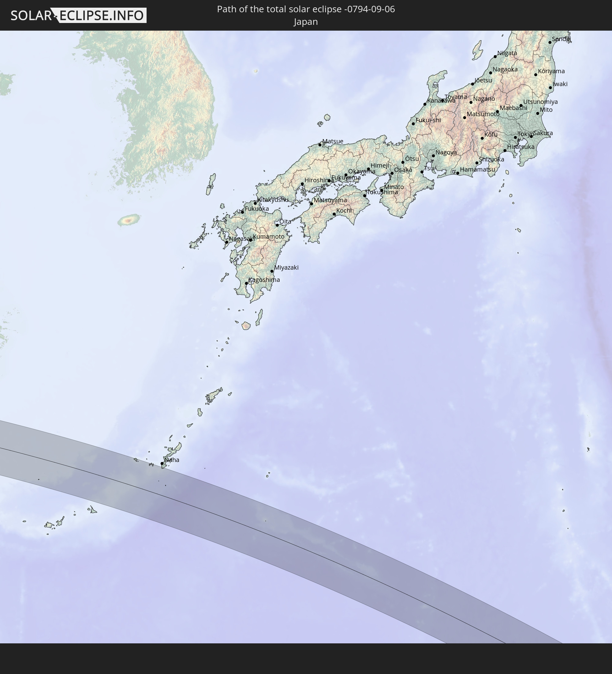 Japan
Japan
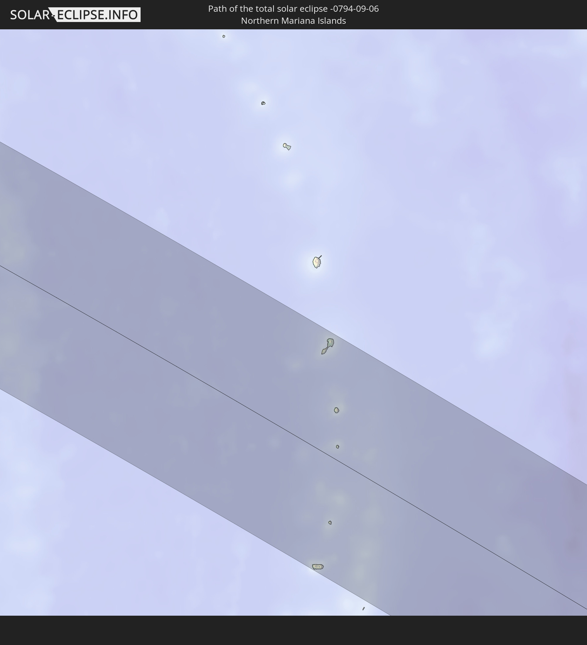 Northern Mariana Islands
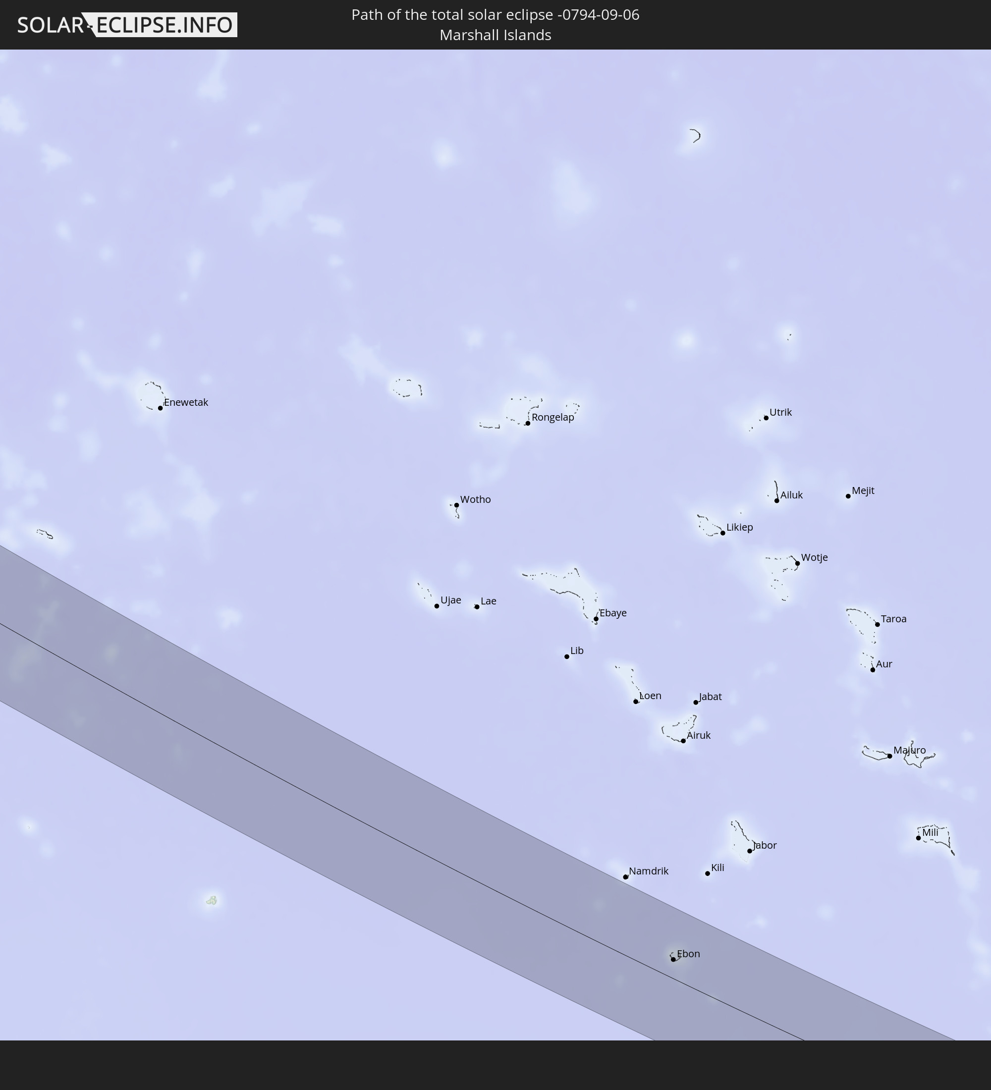 Marshall Islands
In den folgenden Ländern ist die Sonnenfinsternis partiell zu sehen
 Russia
 Fiji
Fiji
 United States
 New Zealand
 United States Minor Outlying Islands
 Wallis and Futuna
 Tonga
Tonga
 Kiribati
 Samoa
Samoa
 Tokelau
 American Samoa
 Niue
Niue
 Cook Islands
 Kazakhstan
 Turkmenistan
 Uzbekistan
 Afghanistan
 Pakistan
 Tajikistan
 India
India
 Kyrgyzstan
 China
China
 Sri Lanka
 Nepal
Nepal
 Mongolia
 Bangladesh
 Bhutan
 Myanmar
 Indonesia
 Thailand
 Malaysia
 Laos
Laos
 Vietnam
 Cambodia
 Singapore
 Australia
 Macau
Macau
 Hong Kong
 Brunei
 Taiwan
 Philippines
 Japan
Japan
 North Korea
 South Korea
 Palau
Palau
 Federated States of Micronesia
 Papua New Guinea
 Guam
Guam
 Northern Mariana Islands
 Solomon Islands
 New Caledonia
 Marshall Islands
 Vanuatu
 Nauru
Nauru
 Norfolk Island
 Tuvalu
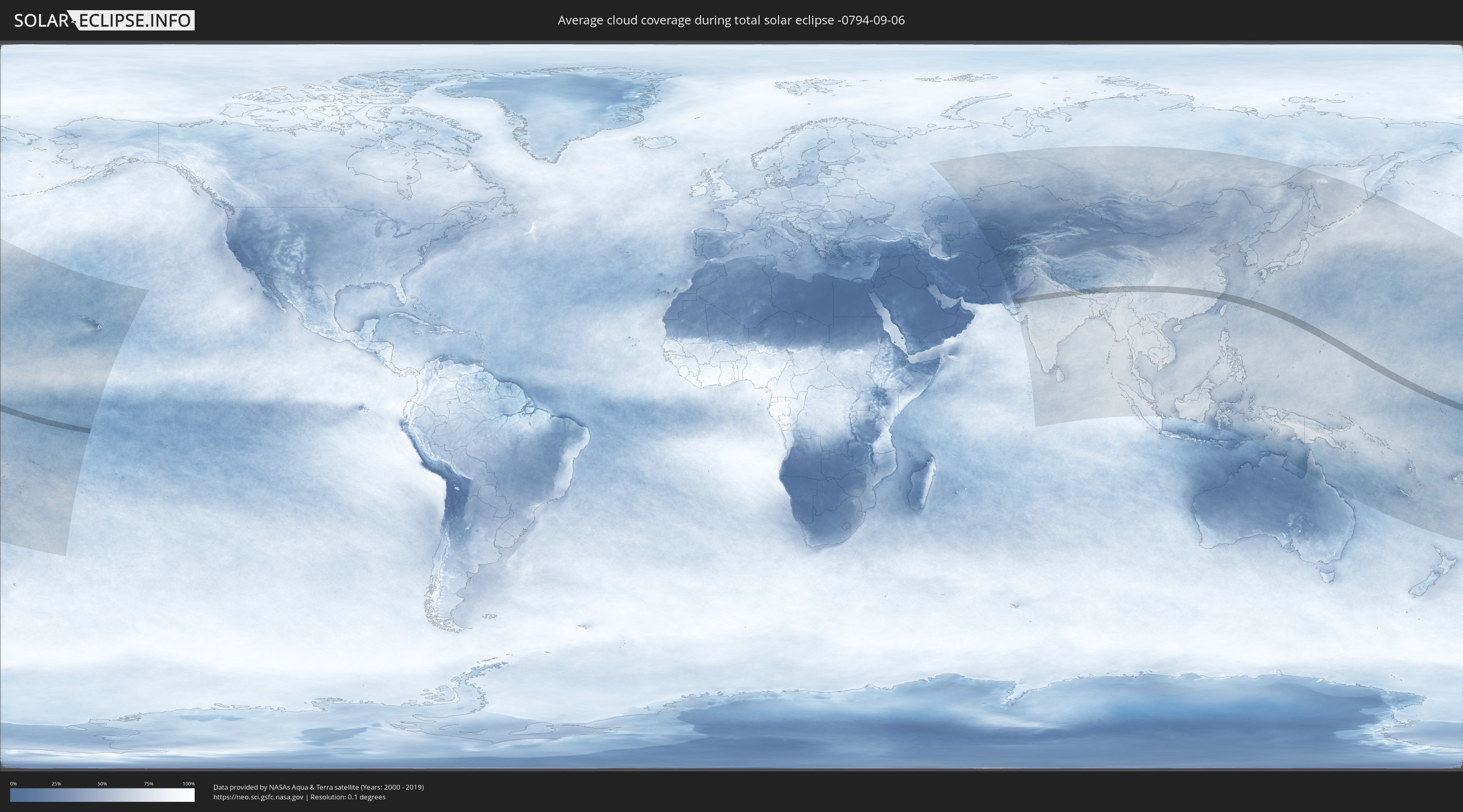
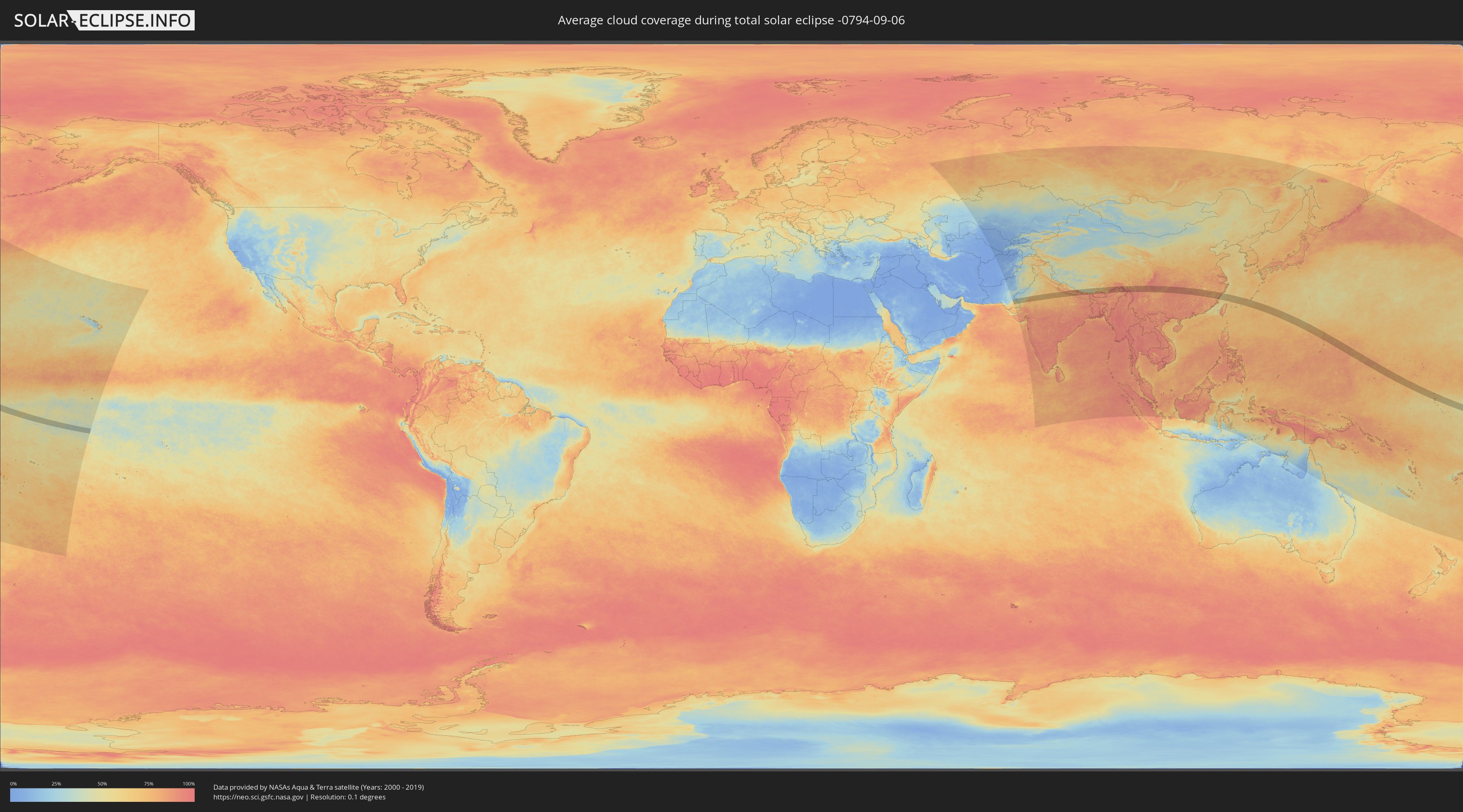
How will be the weather during the total solar eclipse on 09/06/-0794?
Where is the best place to see the total solar eclipse of 09/06/-0794?
The following maps show the average cloud coverage for the day of the total solar eclipse.
With the help of these maps, it is possible to find the place along the eclipse path, which has the best
chance of a cloudless sky.
Nevertheless, you should consider local circumstances and inform about the weather of your chosen
observation site.
The data is provided by NASAs satellites
AQUA and TERRA.
The cloud maps are averaged over a period of 19 years (2000 - 2019).
Detailed country maps
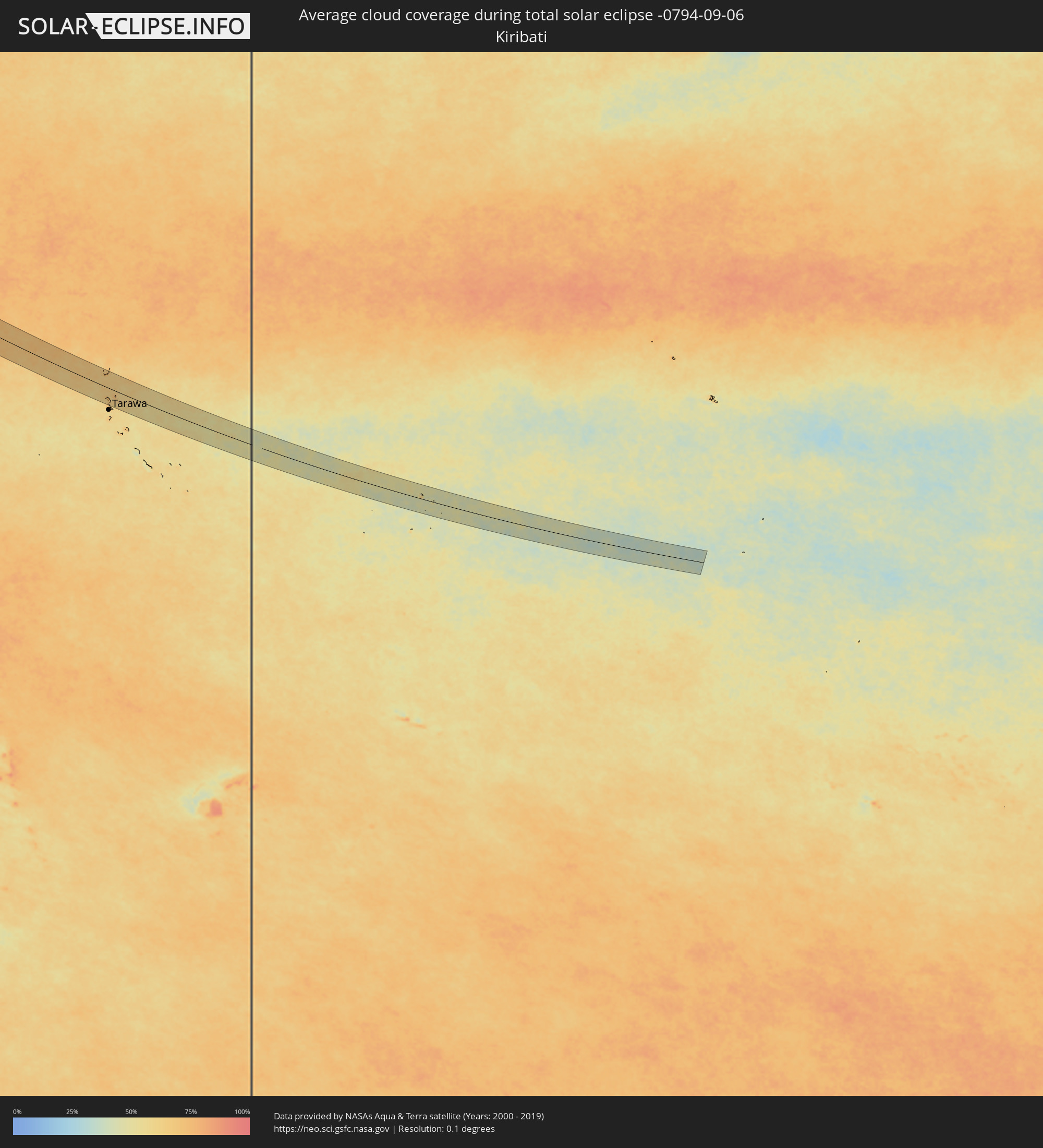 Kiribati
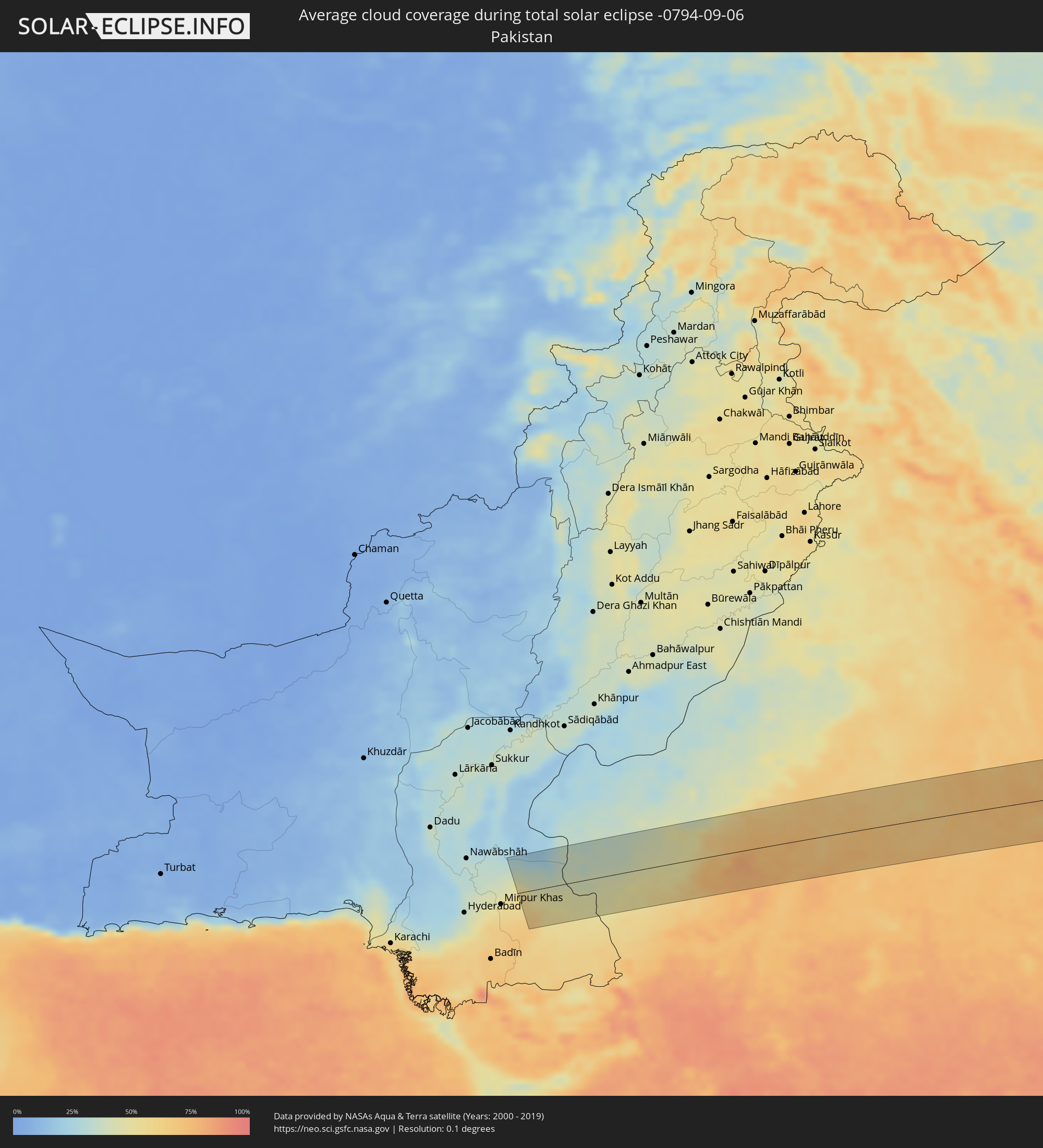 Pakistan
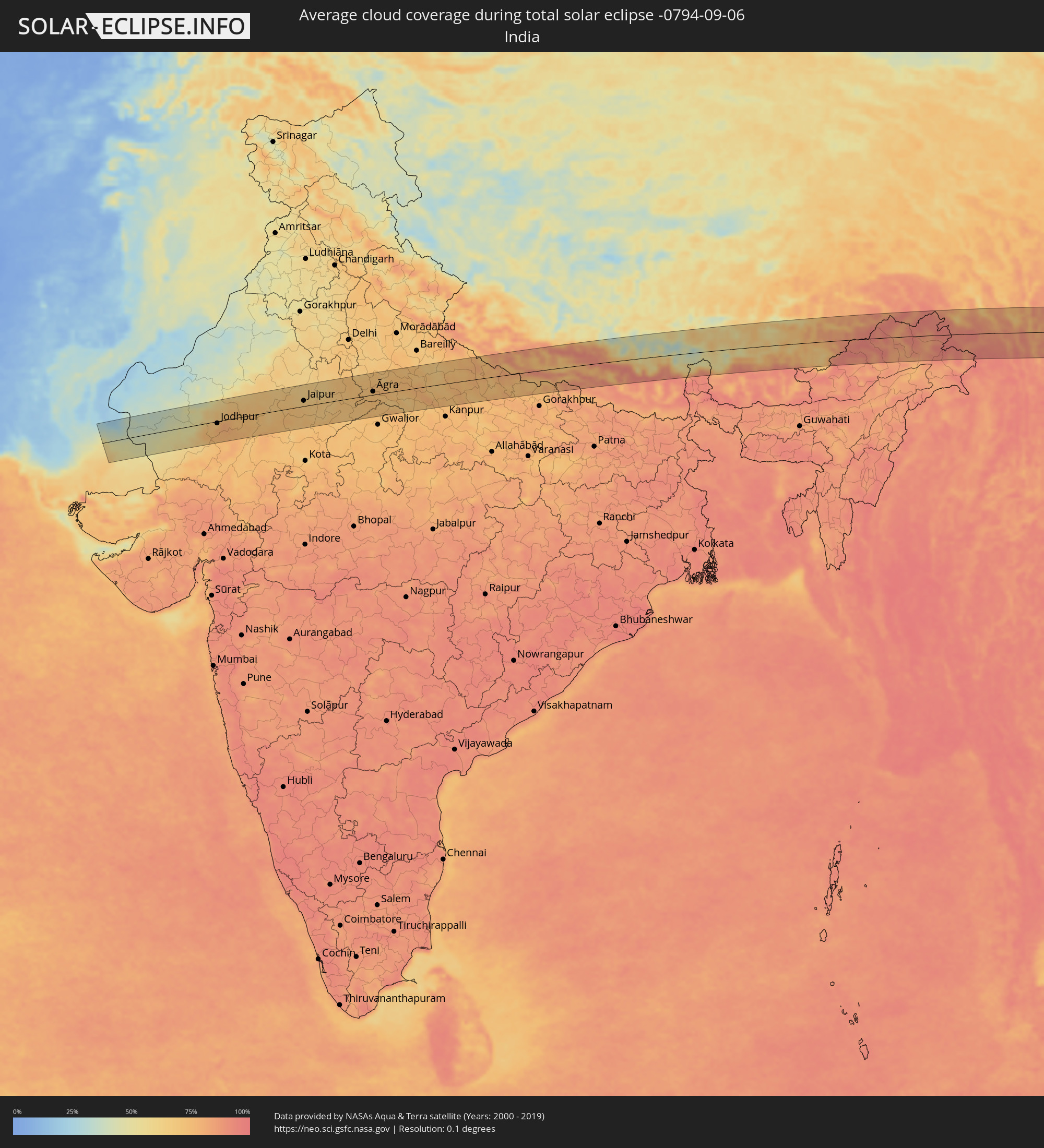 India
India
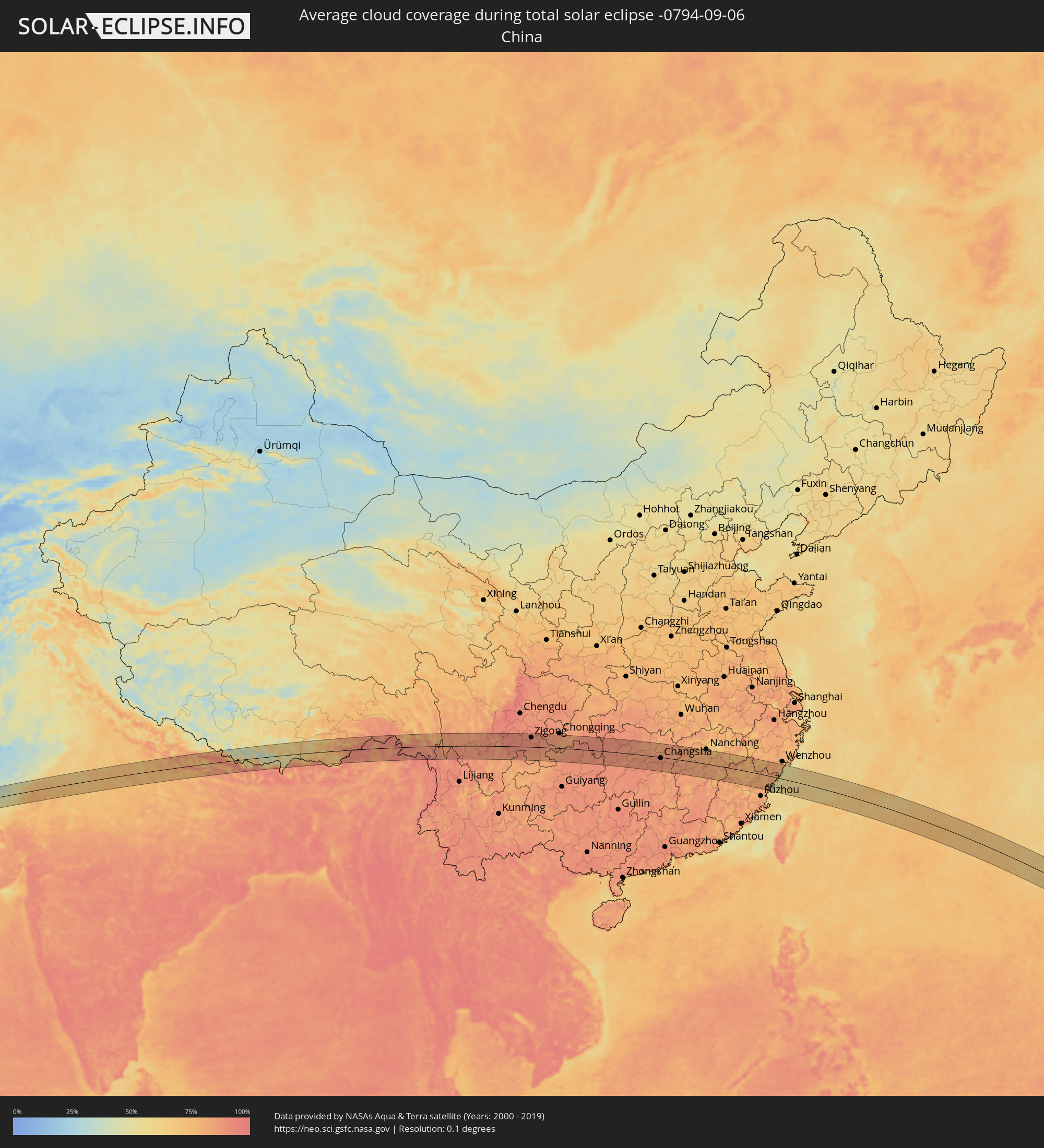 China
China
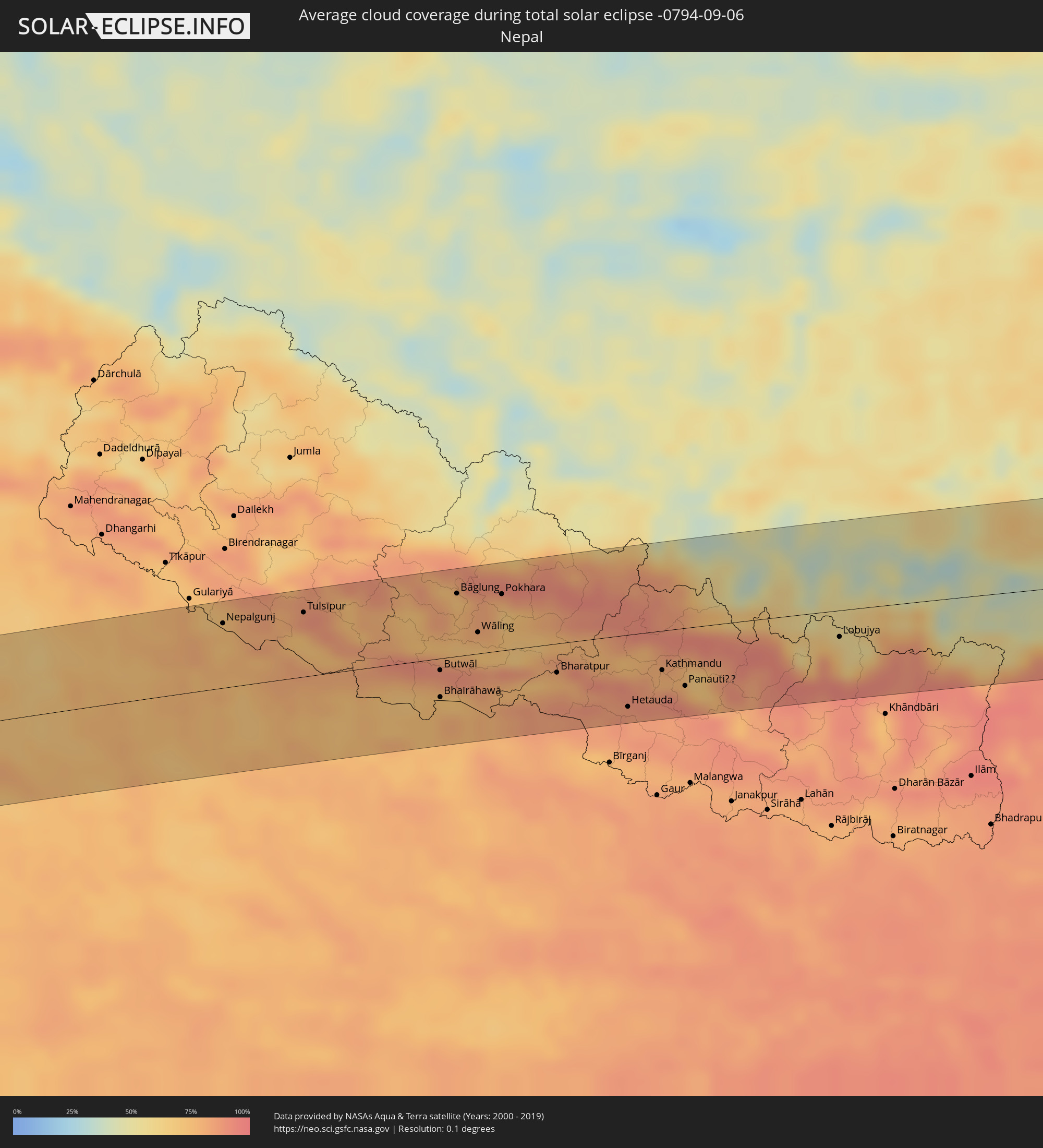 Nepal
Nepal
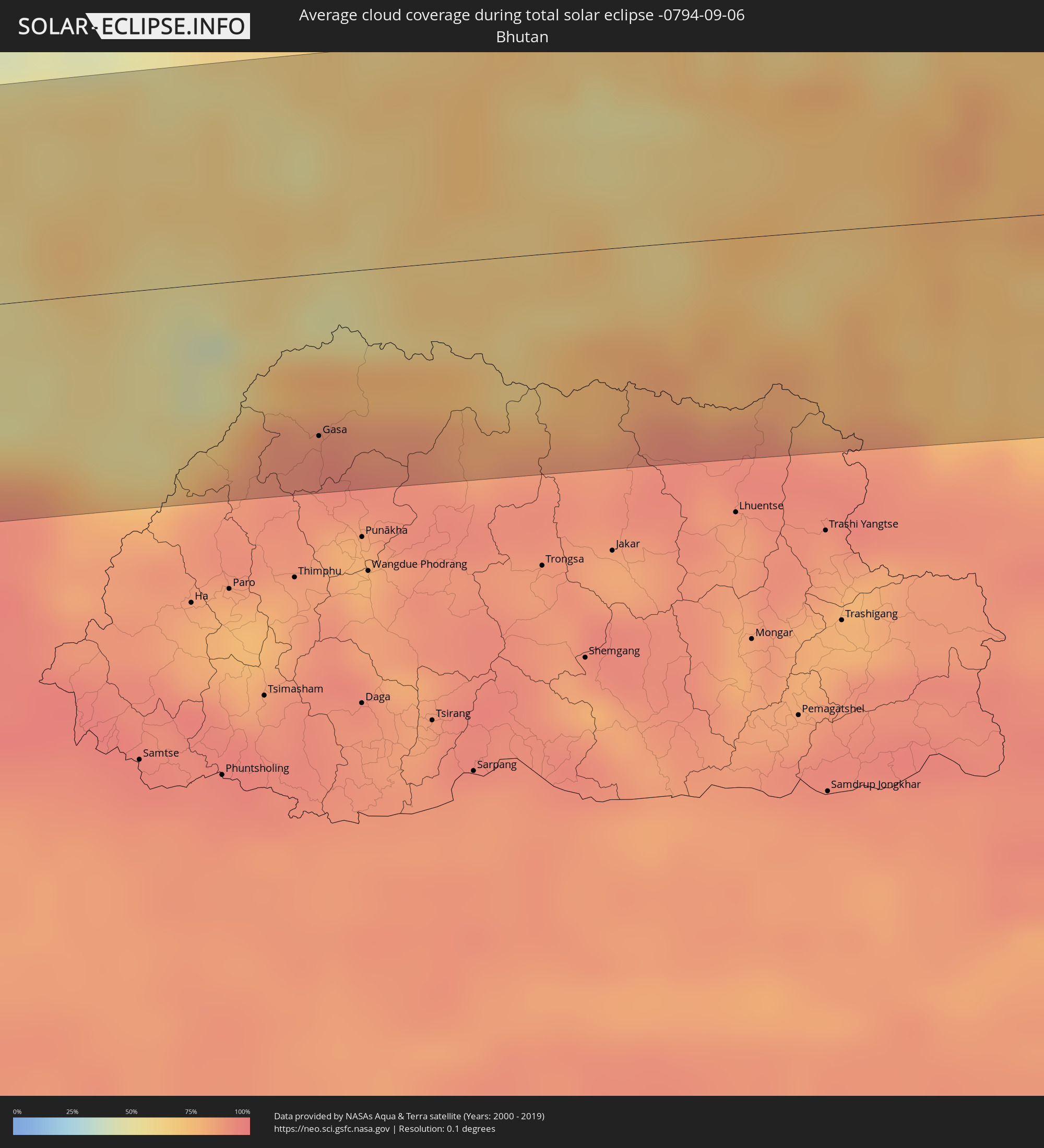 Bhutan
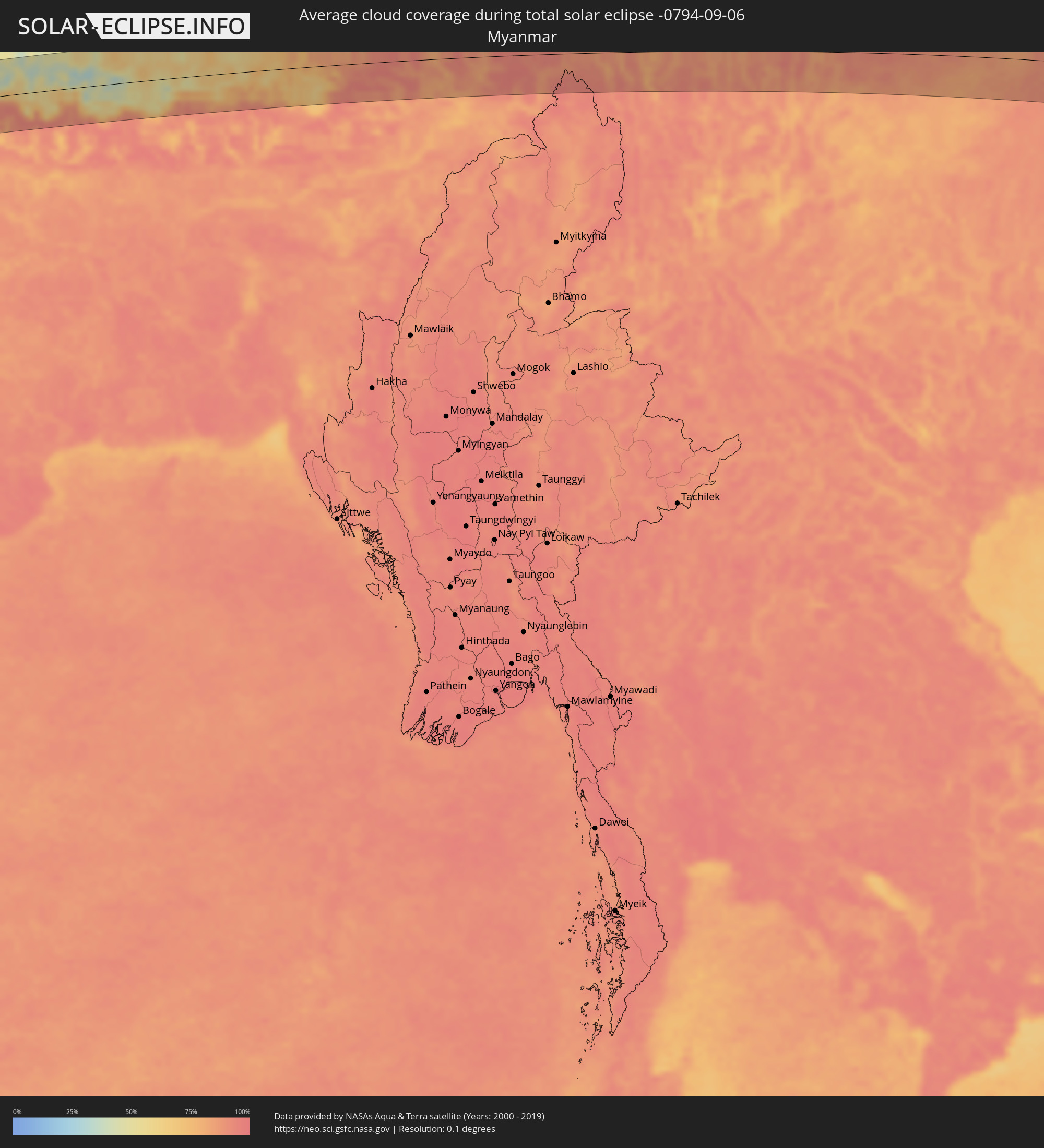 Myanmar
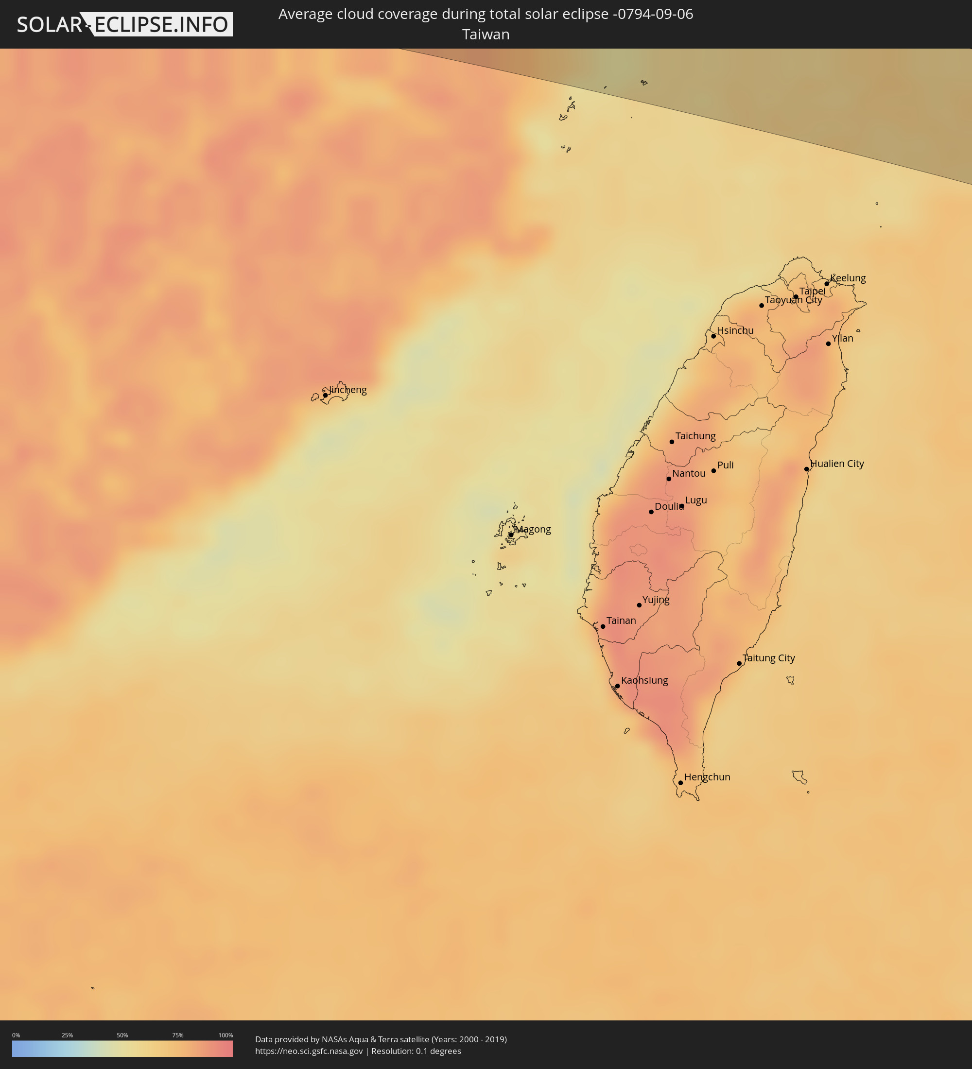 Taiwan
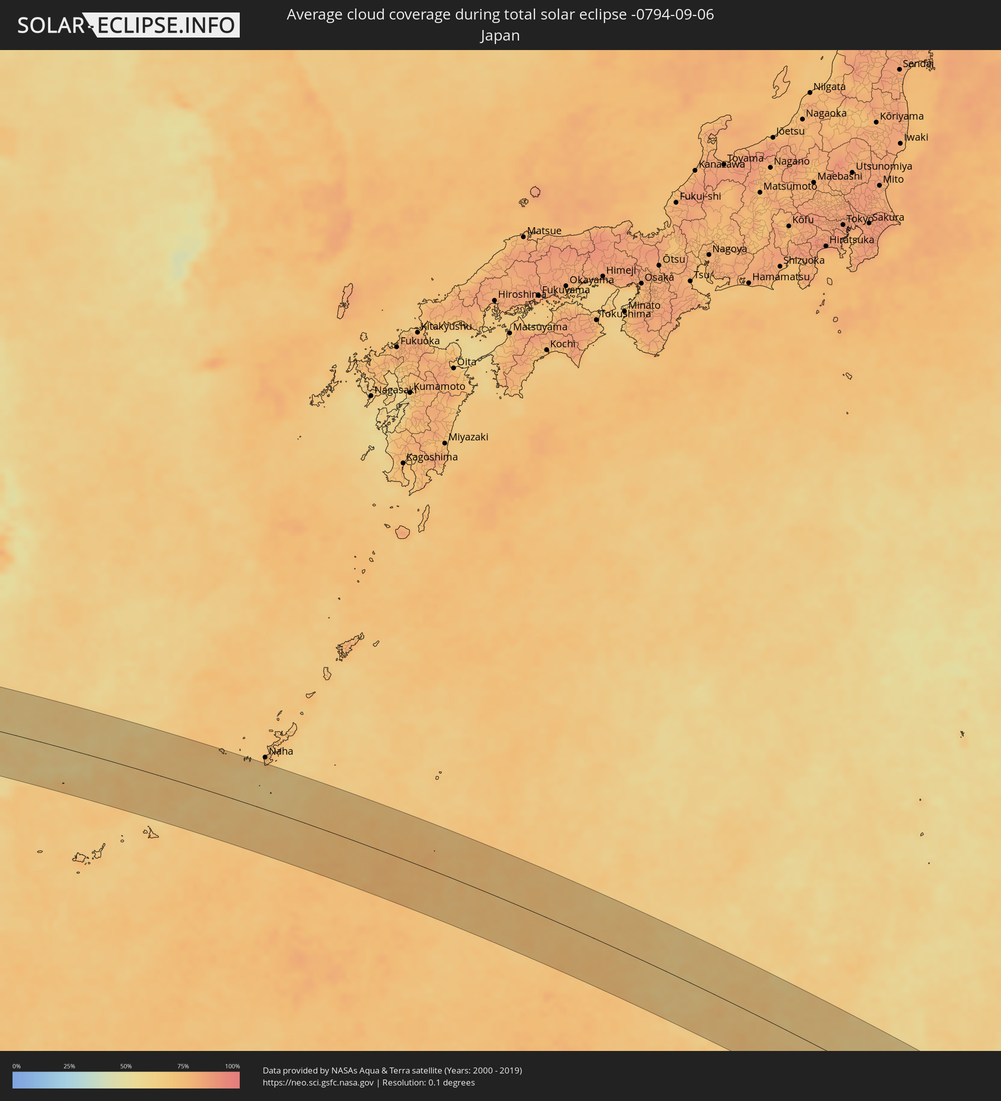 Japan
Japan
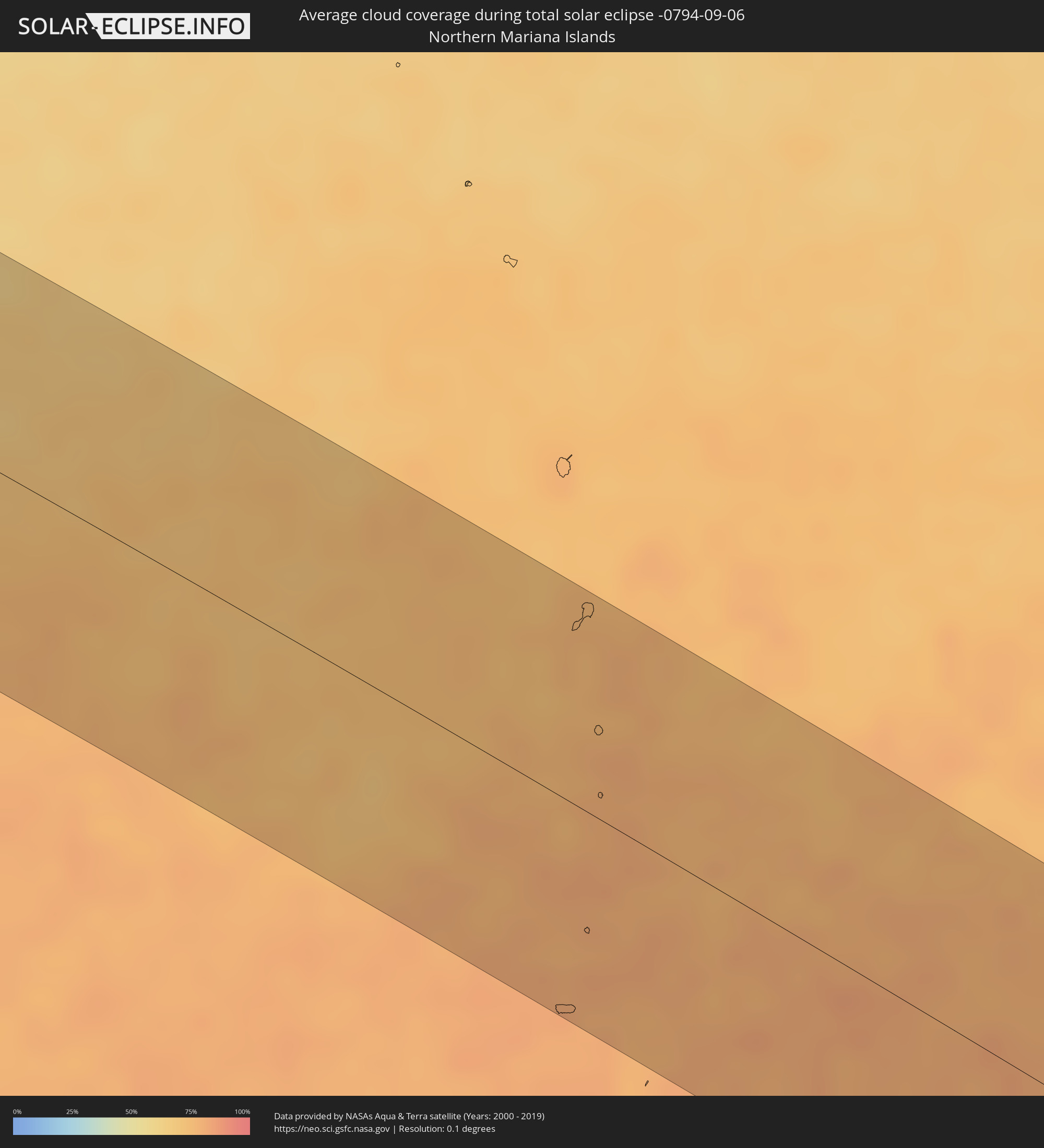 Northern Mariana Islands
 Marshall Islands
Cities inside the path of the eclipse
The following table shows all locations with a population of more than 5,000 inside the eclipse path. Cities which have more than 100,000 inhabitants are marked bold. A click at the locations opens a detailed map.
| City | Type | Eclipse duration | Local time of max. eclipse | Distance to central line | Ø Cloud coverage |
|
Pithoro, Sindh
|
total | - | 05:31:59 UTC+04:28 | 22 km | 57% |
|
Kunri, Sindh
|
total | - | 05:31:50 UTC+04:28 | 62 km | 65% |
|
Dhoro Naro, Sindh
|
total | - | 05:31:58 UTC+04:28 | 26 km | 62% |
|
Umarkot, Sindh
|
total | - | 05:31:54 UTC+04:28 | 45 km | 60% |
|
Chor, Sindh
|
total | - | 05:31:57 UTC+04:28 | 29 km | 54% |
|
Bārmer, Rajasthan
|
total | - | 06:24:57 UTC+05:21 | 34 km | 51% |
|
Jodhpur, Rajasthan
|
total | - | 06:25:12 UTC+05:21 | 6 km | 69% |
|
Pāli, Rajasthan
|
total | - | 06:24:59 UTC+05:21 | 66 km | 76% |
|
Beāwar, Rajasthan
|
total | - | 06:25:11 UTC+05:21 | 48 km | 73% |
|
Ajmer, Rajasthan
|
total | - | 06:25:22 UTC+05:21 | 15 km | 67% |
|
Makrāna, Rajasthan
|
total | - | 06:25:39 UTC+05:21 | 49 km | 68% |
|
Kishangarh, Rajasthan
|
total | - | 06:25:26 UTC+05:21 | 5 km | 70% |
|
Jaipur, Rajasthan
|
total | - | 06:25:41 UTC+05:21 | 17 km | 67% |
|
Tonk, Rajasthan
|
total | - | 06:25:21 UTC+05:21 | 66 km | 69% |
|
Gangāpur, Rajasthan
|
total | - | 06:25:36 UTC+05:21 | 47 km | 72% |
|
Karauli, Rajasthan
|
total | - | 06:25:40 UTC+05:21 | 49 km | 70% |
|
Hindaun, Rajasthan
|
total | - | 06:25:46 UTC+05:21 | 24 km | 70% |
|
Bharatpur, Rajasthan
|
total | - | 06:26:04 UTC+05:21 | 22 km | 72% |
|
Mathura, Uttar Pradesh
|
total | - | 06:26:14 UTC+05:21 | 51 km | 71% |
|
Dhaulpur, Rajasthan
|
total | - | 06:25:53 UTC+05:21 | 41 km | 72% |
|
Morena, Madhya Pradesh
|
total | - | 06:25:49 UTC+05:21 | 65 km | 72% |
|
Āgra, Uttar Pradesh
|
total | - | 06:26:09 UTC+05:21 | 10 km | 72% |
|
Hāthras, Uttar Pradesh
|
total | - | 06:26:21 UTC+05:21 | 55 km | 72% |
|
Fīrozābād, Uttar Pradesh
|
total | - | 06:26:12 UTC+05:21 | 1 km | 73% |
|
Shikohābād, Uttar Pradesh
|
total | - | 06:26:13 UTC+05:21 | 7 km | 72% |
|
Kāsganj, Uttar Pradesh
|
total | - | 06:26:34 UTC+05:21 | 69 km | 71% |
|
Bhind, Madhya Pradesh
|
total | - | 06:26:00 UTC+05:21 | 69 km | 75% |
|
Etāwah, Uttar Pradesh
|
total | - | 06:26:09 UTC+05:21 | 50 km | 67% |
|
Mainpuri, Uttar Pradesh
|
total | - | 06:26:22 UTC+05:21 | 0 km | 69% |
|
Farrukhābād, Uttar Pradesh
|
total | - | 06:26:34 UTC+05:21 | 9 km | 77% |
|
Shāhjānpur, Uttar Pradesh
|
total | - | 06:26:53 UTC+05:21 | 59 km | 69% |
|
Kannauj, Uttar Pradesh
|
total | - | 06:26:29 UTC+05:21 | 33 km | 76% |
|
Hardoī, Uttar Pradesh
|
total | - | 06:26:42 UTC+05:21 | 2 km | 68% |
|
Sītāpur, Uttar Pradesh
|
total | - | 06:26:55 UTC+05:21 | 12 km | 76% |
|
Lakhīmpur, Uttar Pradesh
|
total | - | 06:27:08 UTC+05:21 | 53 km | 74% |
|
Nawābganj, Uttar Pradesh
|
total | - | 06:26:46 UTC+05:21 | 65 km | 74% |
|
Bahraigh, Uttar Pradesh
|
total | - | 06:27:11 UTC+05:21 | 1 km | 77% |
|
Nepalgunj, Mid Western
|
total | - | 06:47:32 UTC+05:41 | 53 km | 74% |
|
Gondā City, Uttar Pradesh
|
total | - | 06:27:05 UTC+05:21 | 53 km | 76% |
|
Balrāmpur, Uttar Pradesh
|
total | - | 06:27:18 UTC+05:21 | 23 km | 75% |
|
Tulsīpur, Mid Western
|
total | - | 06:47:47 UTC+05:41 | 53 km | 73% |
|
Besisahar
|
total | - | 06:47:52 UTC+05:41 | 63 km | 89% |
|
Butwāl, Western Region
|
total | - | 06:47:58 UTC+05:41 | 10 km | 81% |
|
Bhairāhawā, Western Region
|
total | - | 06:47:52 UTC+05:41 | 32 km | 73% |
|
Tānsen, Western Region
|
total | - | 06:48:05 UTC+05:41 | 7 km | 81% |
|
Bāglung, Western Region
|
total | - | 06:48:18 UTC+05:41 | 52 km | 72% |
|
Wāling, Western Region
|
total | - | 06:48:13 UTC+05:41 | 17 km | 71% |
|
Bhattarai Danda, Western Region
|
total | - | 06:48:14 UTC+05:41 | 4 km | 71% |
|
Pokhara, Western Region
|
total | - | 06:48:26 UTC+05:41 | 46 km | 80% |
|
Bharatpur, Central Region
|
total | - | 06:48:20 UTC+05:41 | 24 km | 75% |
|
Hetauda, Central Region
|
total | - | 06:48:28 UTC+05:41 | 59 km | 88% |
|
Kirtipur, Central Region
|
total | - | 06:48:41 UTC+05:41 | 34 km | 78% |
|
Pātan, Central Region
|
total | - | 06:48:42 UTC+05:41 | 35 km | 78% |
|
Kathmandu, Central Region
|
total | - | 06:48:43 UTC+05:41 | 32 km | 78% |
|
Hari Bdr Tamang House, Central Region
|
total | - | 06:48:44 UTC+05:41 | 42 km | 84% |
|
kankrabari Dovan, Central Region
|
total | - | 06:48:44 UTC+05:41 | 42 km | 84% |
|
Panauti̇̄, Central Region
|
total | - | 06:48:44 UTC+05:41 | 48 km | 84% |
|
Banepā, Central Region
|
total | - | 06:48:46 UTC+05:41 | 42 km | 84% |
|
Lobujya, Eastern Region
|
total | - | 06:49:31 UTC+05:41 | 22 km | 67% |
|
Gasa, Gasa District
|
total | - | 07:08:24 UTC+05:58 | 55 km | 91% |
|
Leshan, Sichuan
|
total | - | 09:22:51 UTC+08:00 | 80 km | 90% |
|
Luocheng, Sichuan
|
total | - | 09:23:07 UTC+08:00 | 61 km | 90% |
|
Yibin, Sichuan
|
total | - | 09:23:40 UTC+08:00 | 6 km | 89% |
|
Xunchang, Sichuan
|
total | - | 09:23:42 UTC+08:00 | 41 km | 87% |
|
Zigong, Sichuan
|
total | - | 09:24:00 UTC+08:00 | 58 km | 89% |
|
Yongchuan, Chongqing
|
total | - | 09:25:25 UTC+08:00 | 64 km | 87% |
|
Yudong, Chongqing
|
total | - | 09:26:13 UTC+08:00 | 71 km | 86% |
|
Loushanguan, Guizhou
|
total | - | 09:26:22 UTC+08:00 | 67 km | 87% |
|
Fenghuang, Hunan
|
total | - | 09:30:16 UTC+08:00 | 69 km | 90% |
|
Qianzhou, Hunan
|
total | - | 09:30:31 UTC+08:00 | 25 km | 88% |
|
Zhangjiajie, Hunan
|
total | - | 09:31:43 UTC+08:00 | 71 km | 91% |
|
Shangmei, Hunan
|
total | - | 09:32:51 UTC+08:00 | 74 km | 88% |
|
Lengshuijiang, Hunan
|
total | - | 09:33:03 UTC+08:00 | 79 km | 90% |
|
Lianyuan, Hunan
|
total | - | 09:33:25 UTC+08:00 | 76 km | 89% |
|
Changde, Hunan
|
total | - | 09:33:32 UTC+08:00 | 74 km | 86% |
|
Loudi, Hunan
|
total | - | 09:33:57 UTC+08:00 | 67 km | 89% |
|
Yiyang, Hunan
|
total | - | 09:34:31 UTC+08:00 | 31 km | 89% |
|
Qionghu, Hunan
|
total | - | 09:34:36 UTC+08:00 | 59 km | 83% |
|
Xiangxiang, Hunan
|
total | - | 09:34:49 UTC+08:00 | 61 km | 90% |
|
Xiangtan, Hunan
|
total | - | 09:35:25 UTC+08:00 | 44 km | 88% |
|
Changsha, Hunan
|
total | - | 09:35:32 UTC+08:00 | 5 km | 90% |
|
Zhuzhou, Hunan
|
total | - | 09:35:50 UTC+08:00 | 43 km | 86% |
|
Xishan, Hunan
|
total | - | 09:36:25 UTC+08:00 | 57 km | 85% |
|
Guankou, Hunan
|
total | - | 09:36:37 UTC+08:00 | 1 km | 86% |
|
Pingxiang, Jiangxi
|
total | - | 09:37:01 UTC+08:00 | 57 km | 84% |
|
Yichun, Jiangxi
|
total | - | 09:37:56 UTC+08:00 | 26 km | 84% |
|
Xinyu, Jiangxi
|
total | - | 09:38:51 UTC+08:00 | 21 km | 85% |
|
Guixi, Jiangxi
|
total | - | 09:42:50 UTC+08:00 | 69 km | 77% |
|
Shaowu, Fujian
|
total | - | 09:43:29 UTC+08:00 | 30 km | 78% |
|
Ningde, Fujian
|
total | - | 09:47:32 UTC+08:00 | 64 km | 76% |
|
Chengyang, Fujian
|
total | - | 09:47:39 UTC+08:00 | 15 km | 74% |
|
Fuding, Fujian
|
total | - | 09:48:42 UTC+08:00 | 23 km | 74% |
|
Kunyang, Zhejiang
|
total | - | 09:49:17 UTC+08:00 | 67 km | 76% |
|
Jinxiang, Zhejiang
|
total | - | 09:49:26 UTC+08:00 | 43 km | 65% |
|
Ebon, Ebon Atoll
|
total | - | 15:01:01 UTC+11:00 | 23 km | 73% |