Total solar eclipse of 05/14/-0797
| Day of week: | Monday |
| Maximum duration of eclipse: | 06m47s |
| Maximum width of eclipse path: | 320 km |
| Saros cycle: | 54 |
| Coverage: | 100% |
| Magnitude: | 1.0778 |
| Gamma: | -0.6224 |
Wo kann man die Sonnenfinsternis vom 05/14/-0797 sehen?
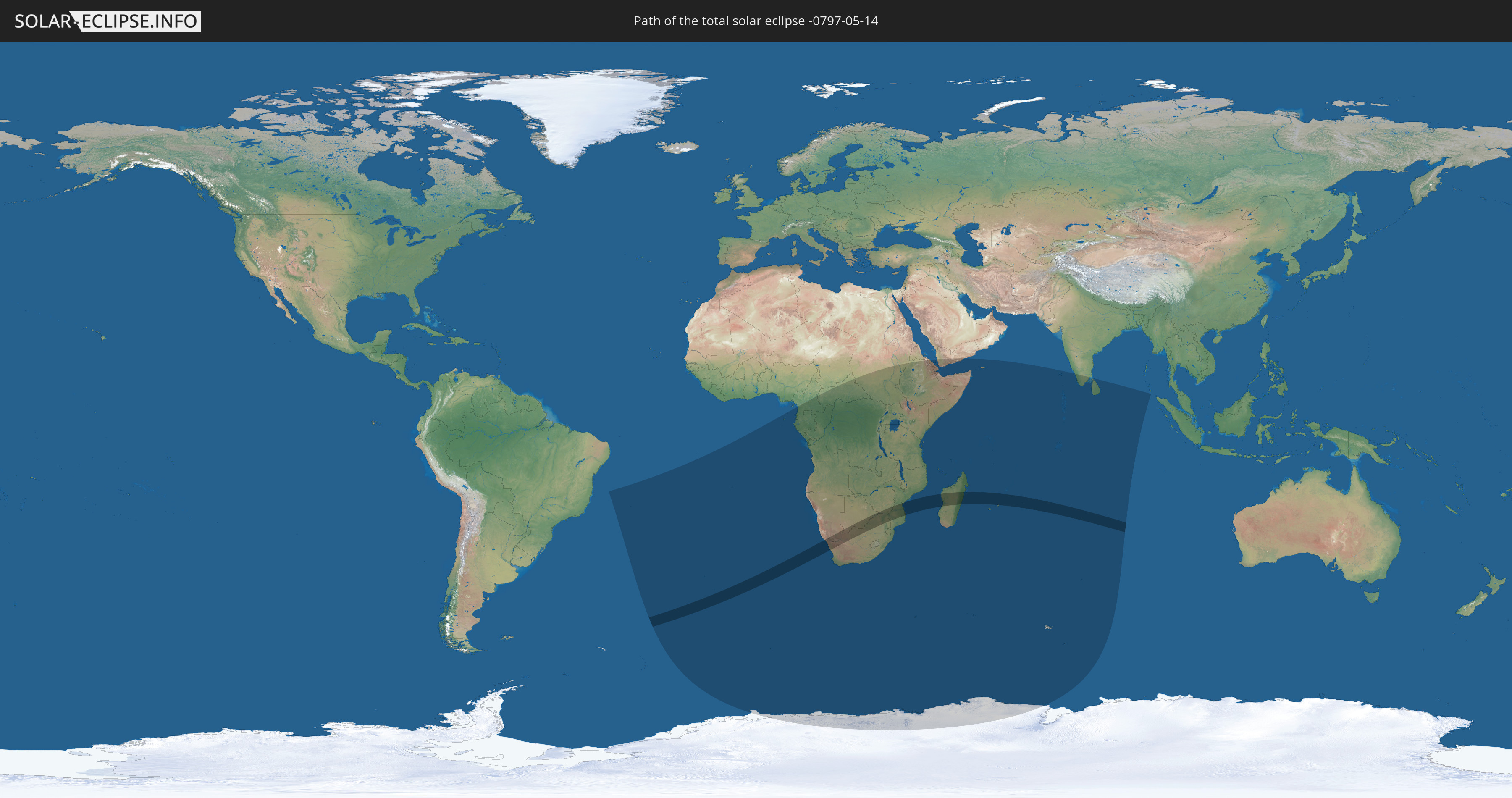
Die Sonnenfinsternis am 05/14/-0797 kann man in 44 Ländern als partielle Sonnenfinsternis beobachten.
Der Finsternispfad verläuft durch 7 Länder. Nur in diesen Ländern ist sie als total Sonnenfinsternis zu sehen.
In den folgenden Ländern ist die Sonnenfinsternis total zu sehen
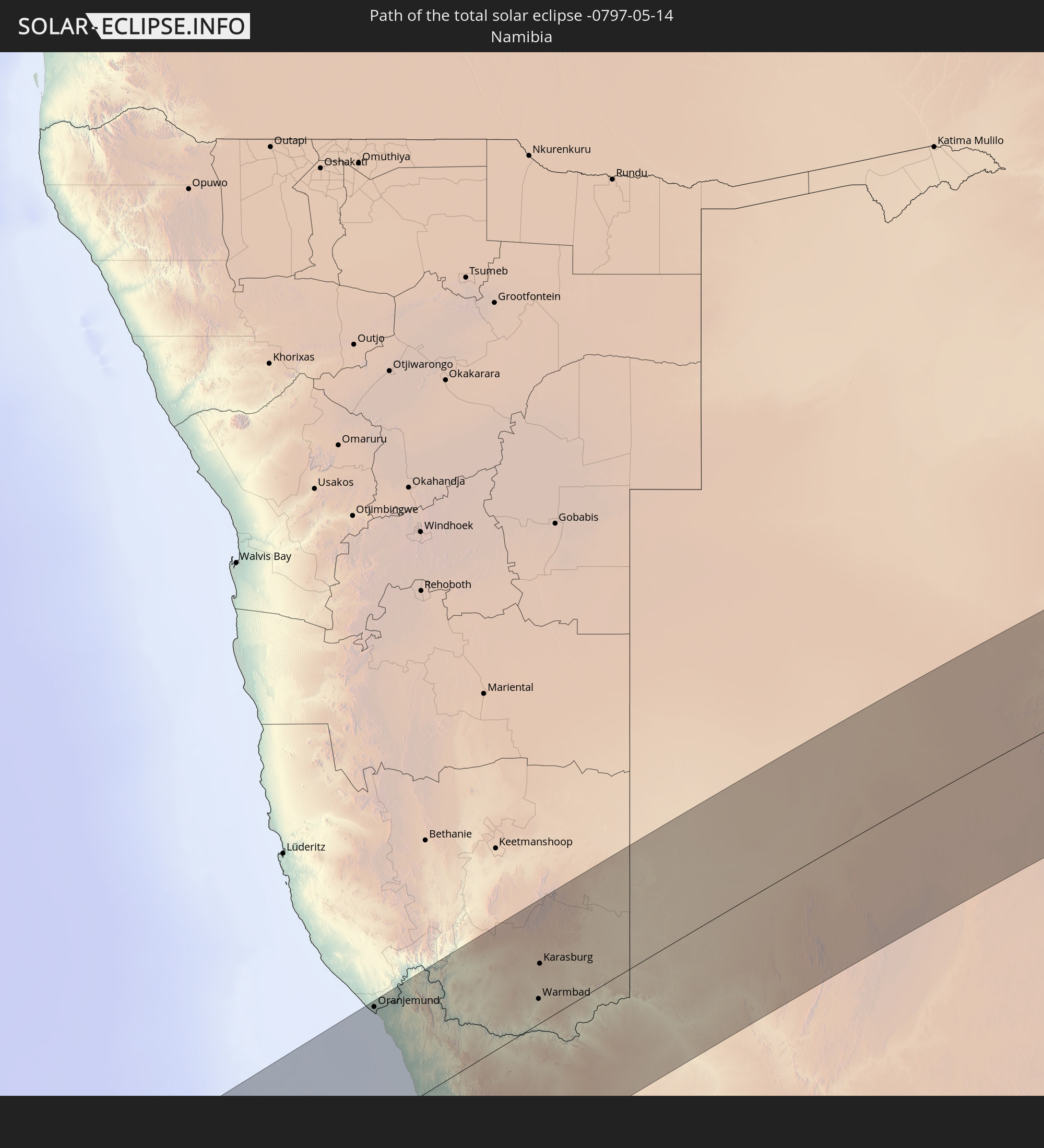 Namibia
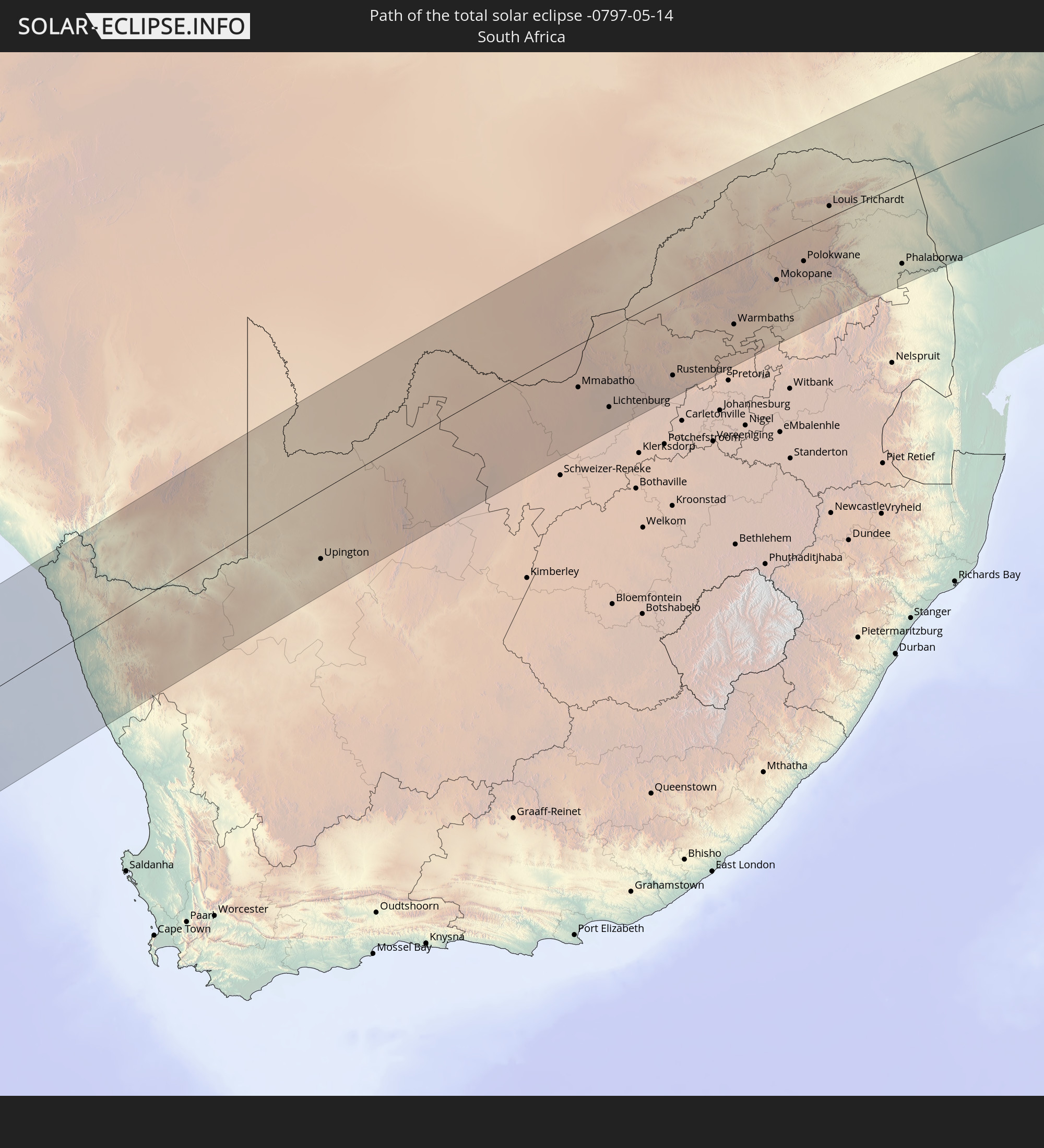 South Africa
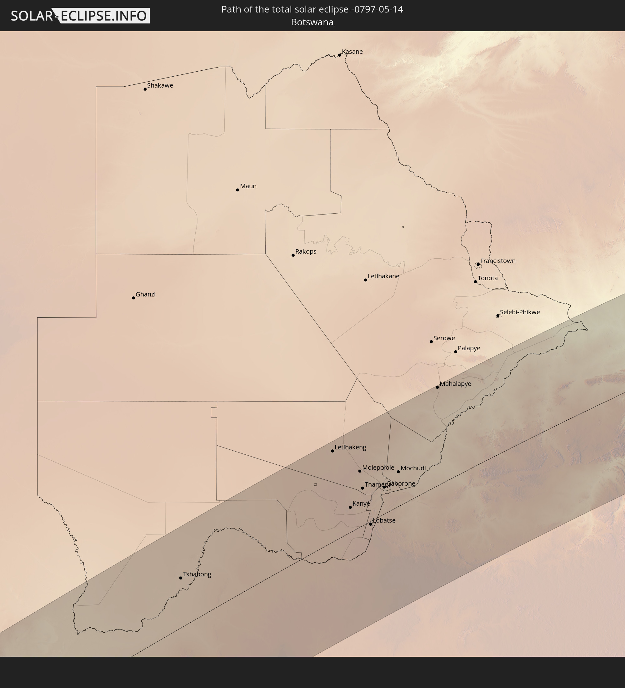 Botswana
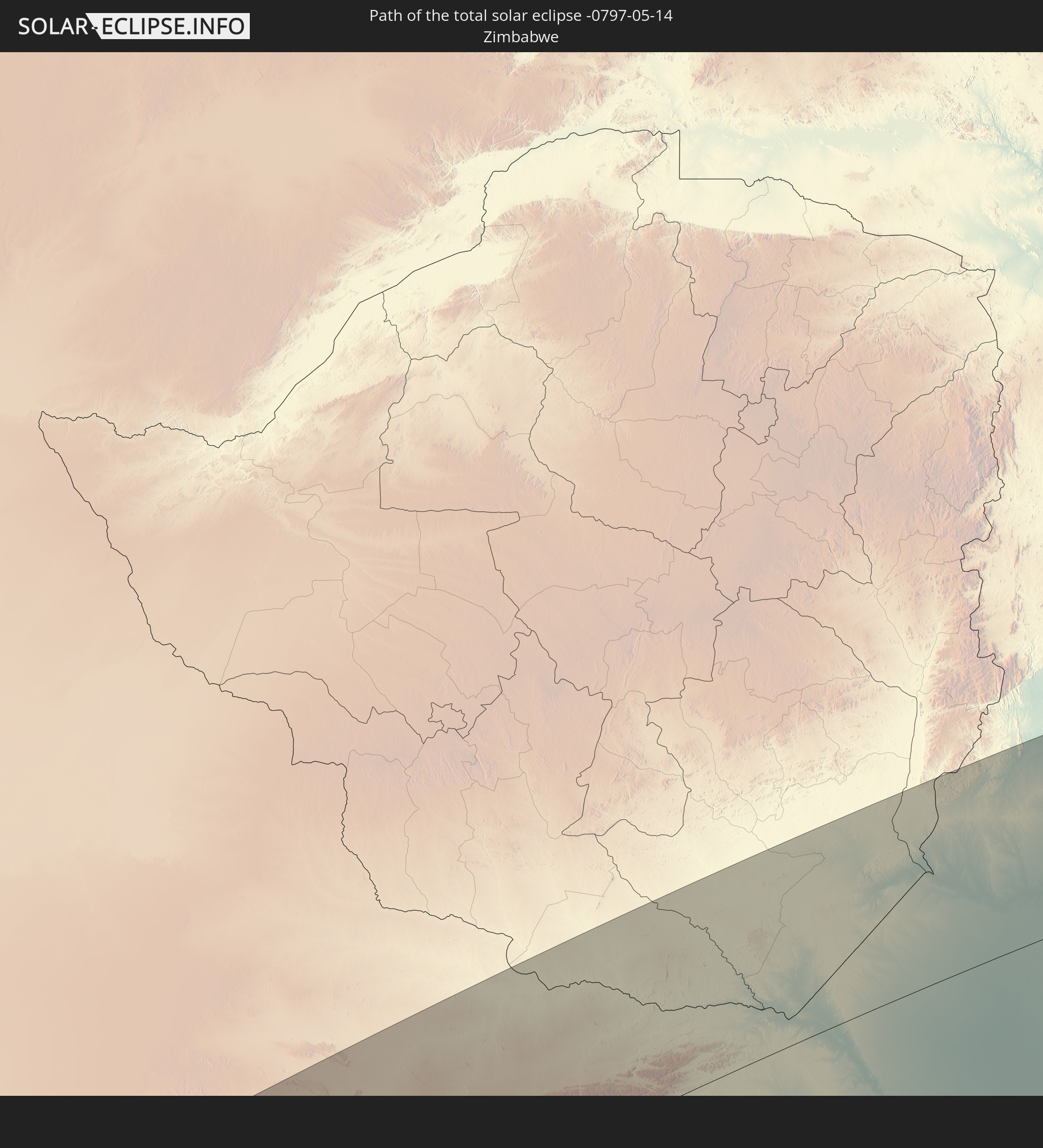 Zimbabwe
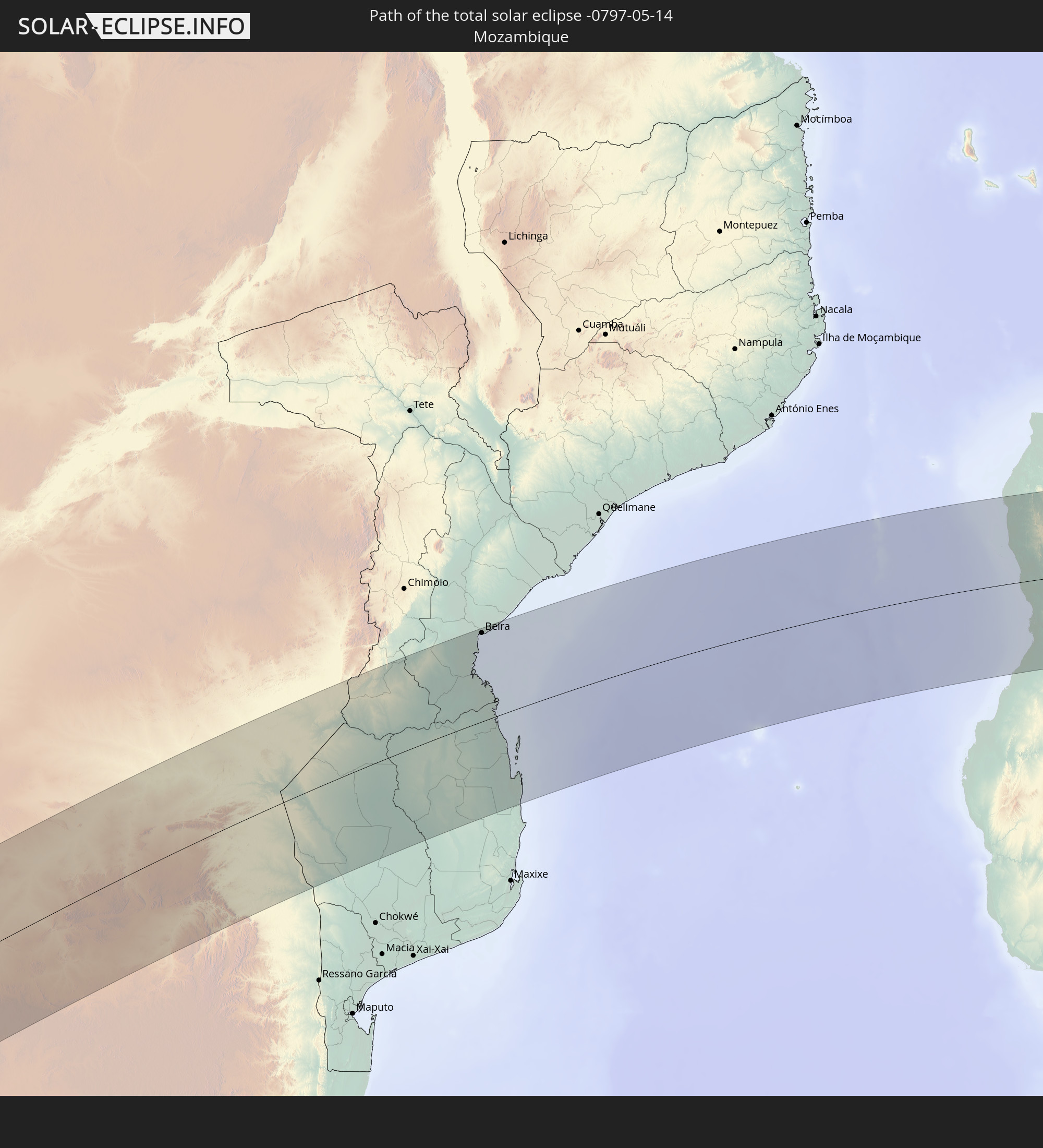 Mozambique
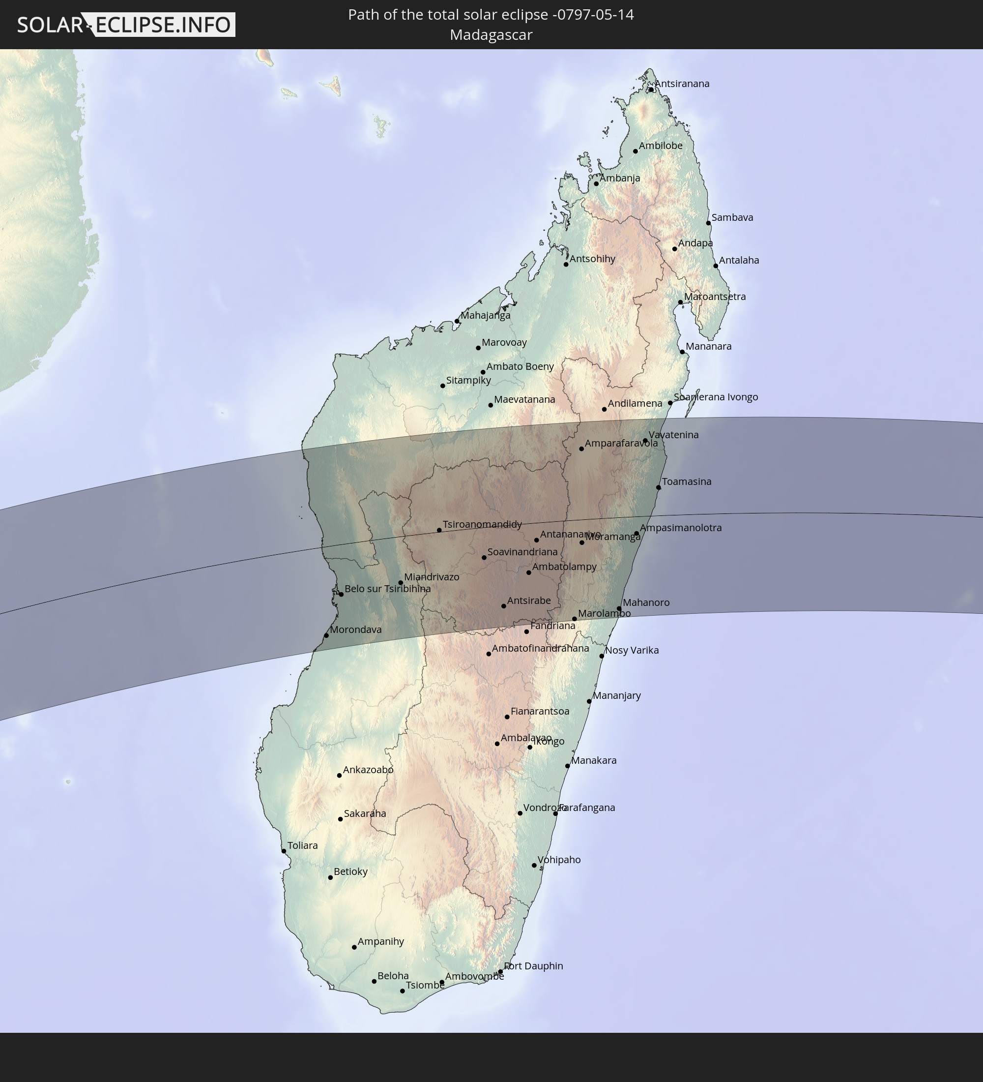 Madagascar
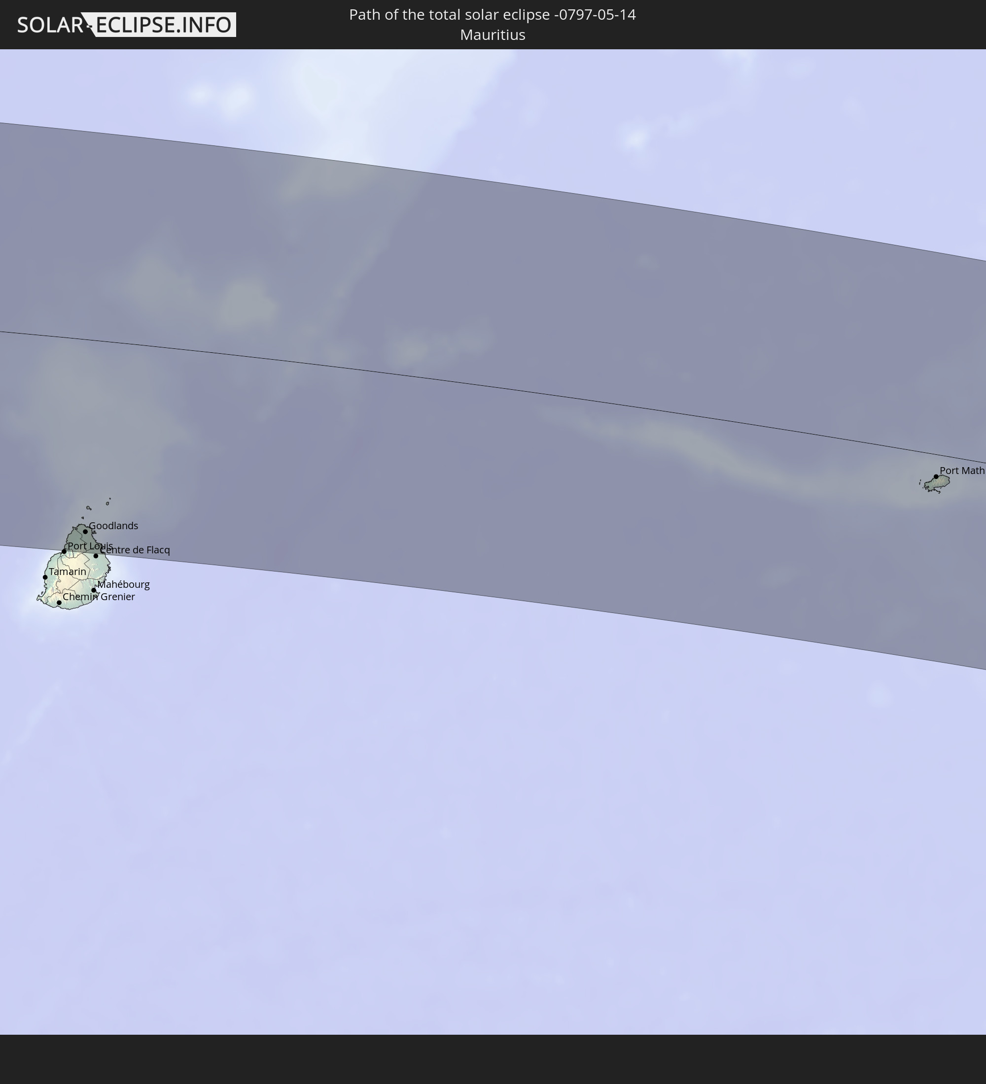 Mauritius
In den folgenden Ländern ist die Sonnenfinsternis partiell zu sehen
 Antarctica
 Brazil
 Saint Helena, Ascension and Tristan da Cunha
 Bouvet Island
 Equatorial Guinea
 São Tomé and Príncipe
 Cameroon
 Gabon
Gabon
 Republic of the Congo
 Angola
 Namibia
 Democratic Republic of the Congo
 Central African Republic
 South Africa
 Botswana
 Sudan
Sudan
 Zambia
 Zimbabwe
 Lesotho
 Rwanda
 Burundi
 Tanzania
 Uganda
 Mozambique
 Swaziland
 Malawi
 Ethiopia
 Kenya
Kenya
 Eritrea
 French Southern and Antarctic Lands
 Somalia
 Djibouti
 Yemen
Yemen
 Madagascar
 Comoros
 Mayotte
 Seychelles
 Réunion
 Mauritius
 India
India
 British Indian Ocean Territory
 Heard Island and McDonald Islands
 Maldives
 Sri Lanka
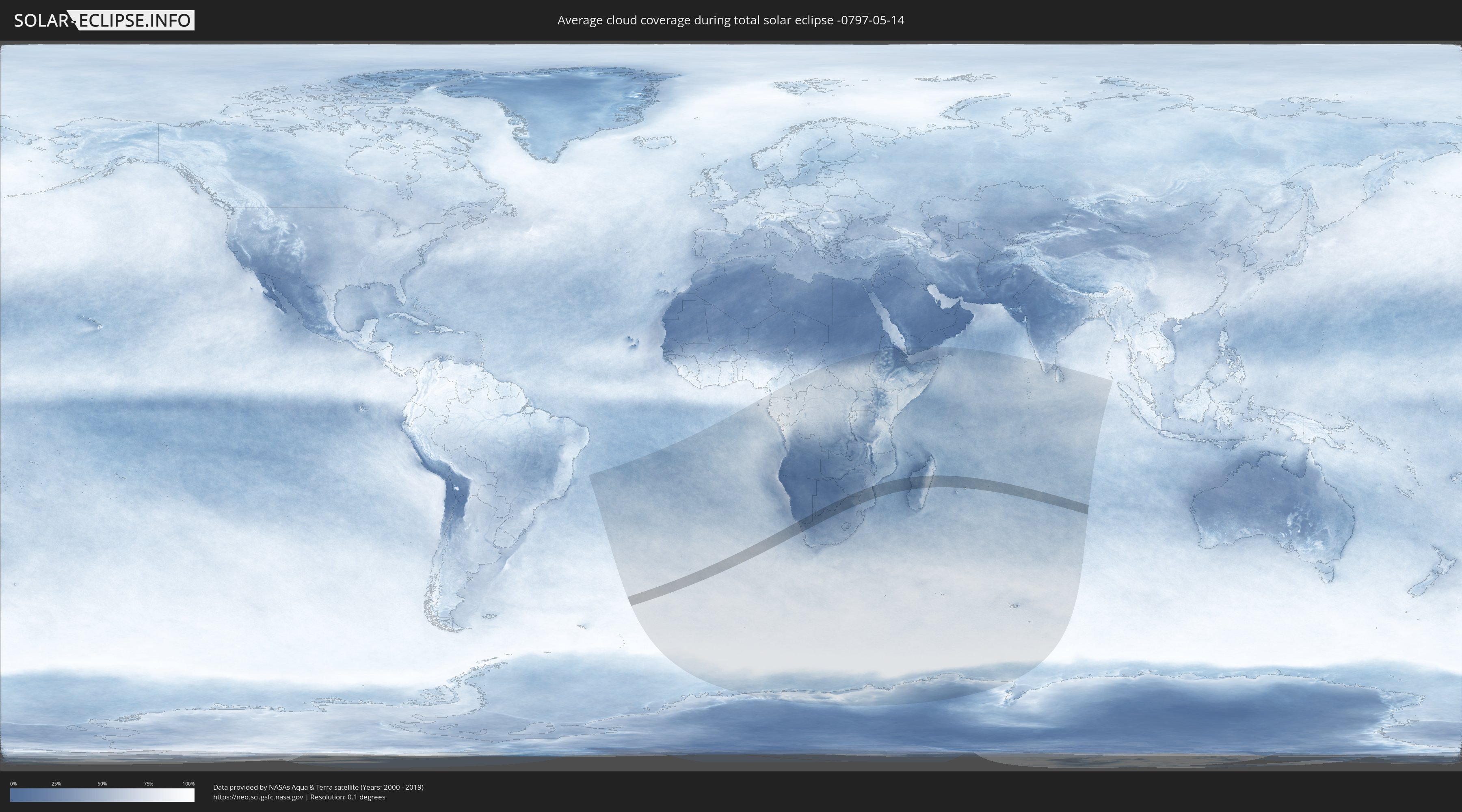
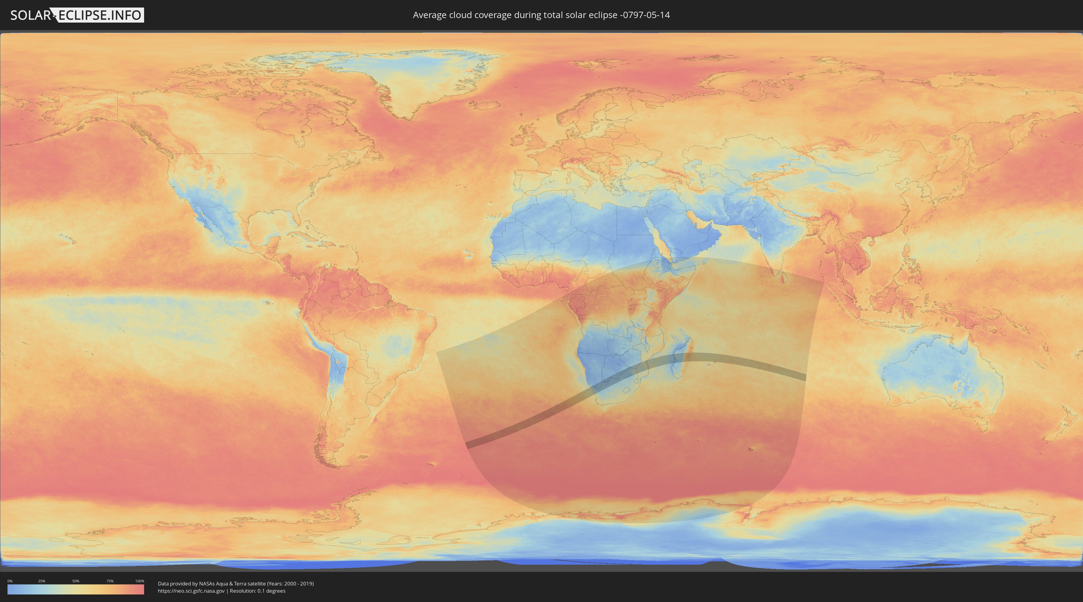
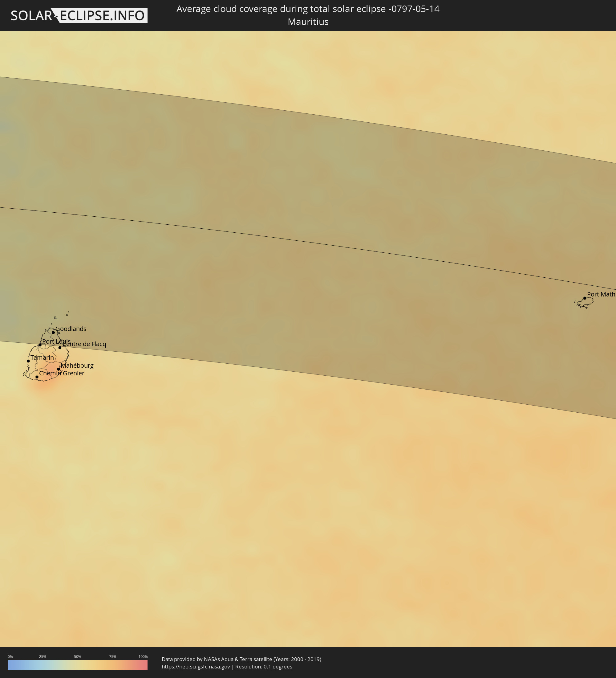
How will be the weather during the total solar eclipse on 05/14/-0797?
Where is the best place to see the total solar eclipse of 05/14/-0797?
The following maps show the average cloud coverage for the day of the total solar eclipse.
With the help of these maps, it is possible to find the place along the eclipse path, which has the best
chance of a cloudless sky.
Nevertheless, you should consider local circumstances and inform about the weather of your chosen
observation site.
The data is provided by NASAs satellites
AQUA and TERRA.
The cloud maps are averaged over a period of 19 years (2000 - 2019).
Detailed country maps
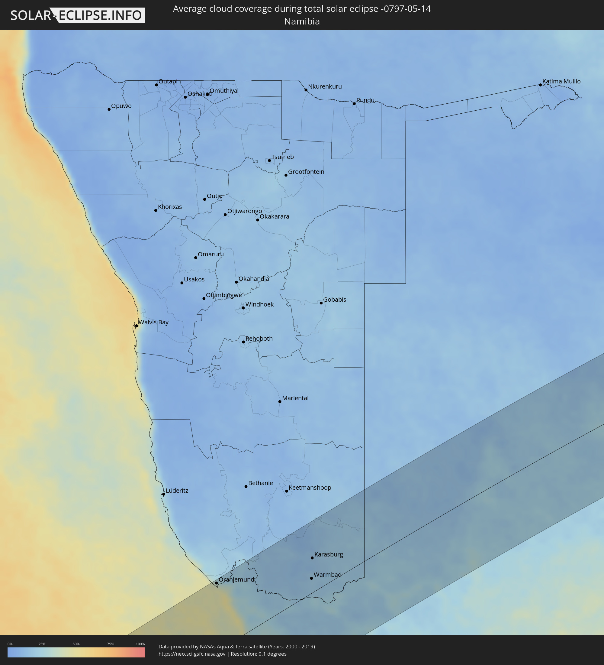 Namibia
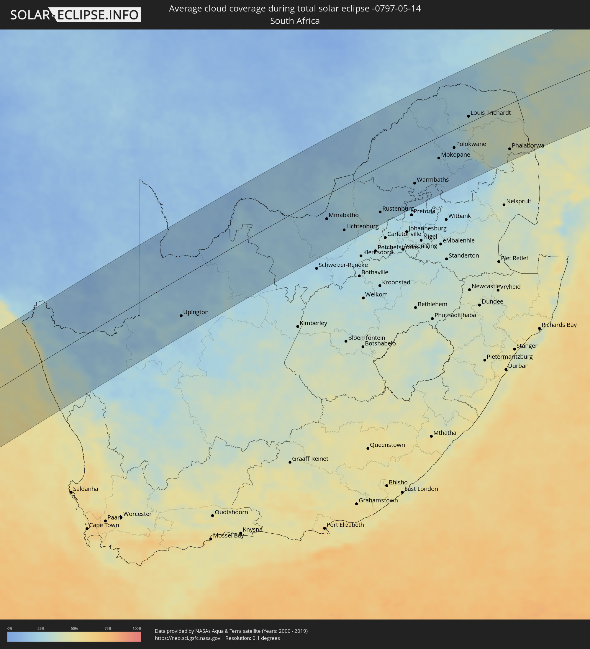 South Africa
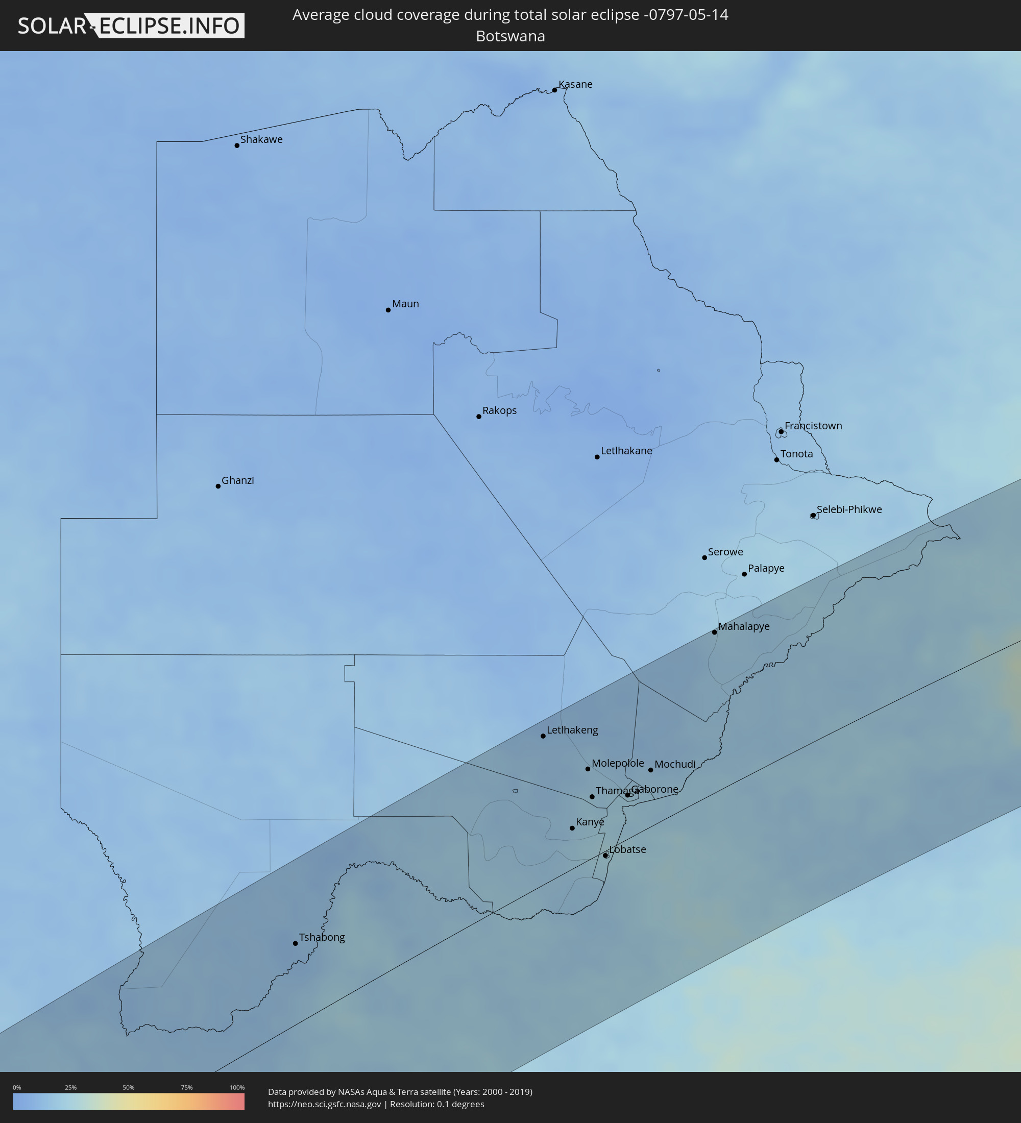 Botswana
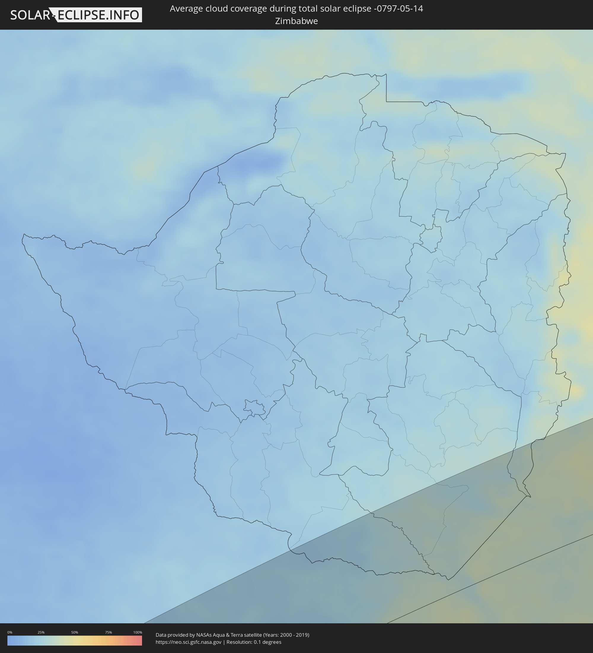 Zimbabwe
 Mozambique
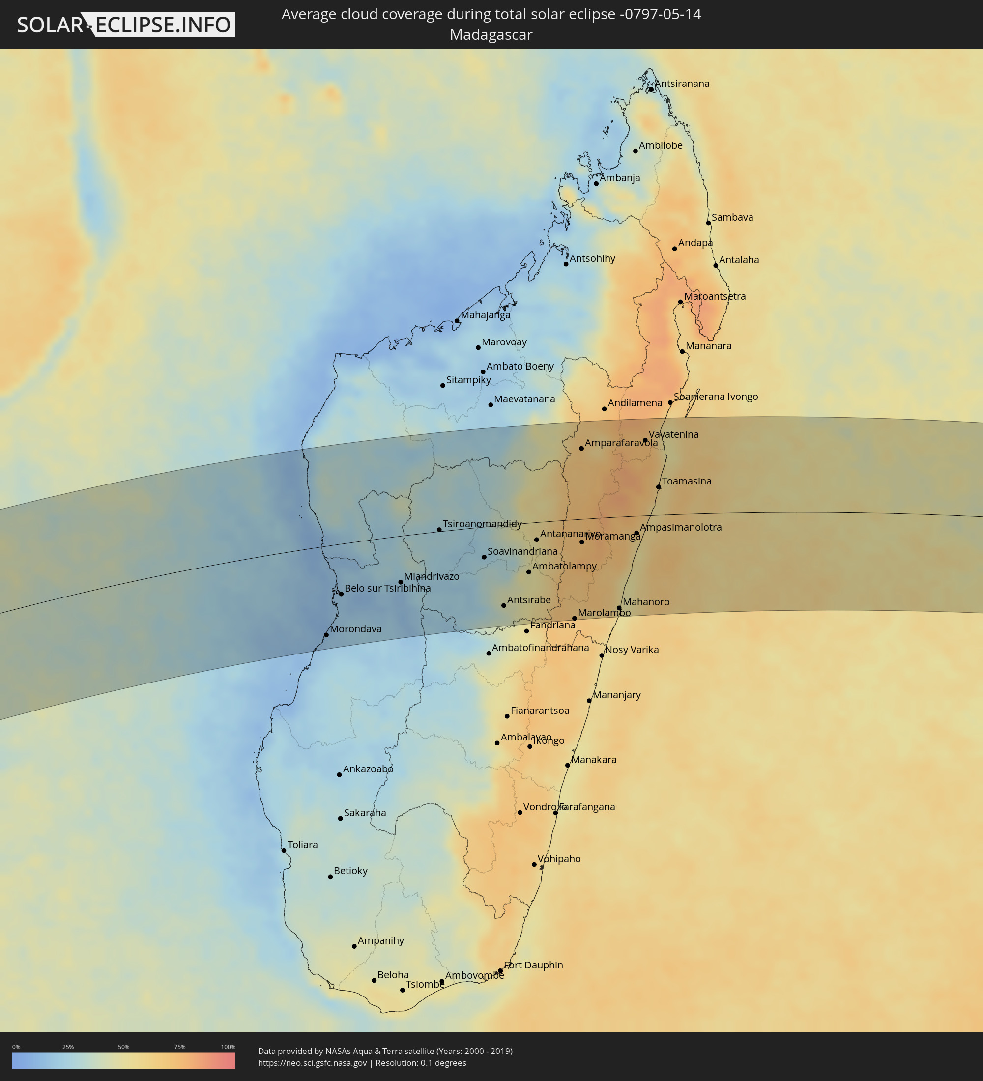 Madagascar
 Mauritius
Cities inside the path of the eclipse
The following table shows all locations with a population of more than 5,000 inside the eclipse path. Cities which have more than 100,000 inhabitants are marked bold. A click at the locations opens a detailed map.
| City | Type | Eclipse duration | Local time of max. eclipse | Distance to central line | Ø Cloud coverage |
|
Oranjemund, Karas
|
total | - | 10:52:11 UTC+01:30 | 136 km | 45% |
|
Springbok, Northern Cape
|
total | - | 10:54:44 UTC+01:30 | 43 km | 28% |
|
Warmbad, Karas
|
total | - | 10:56:52 UTC+01:30 | 29 km | 19% |
|
Karasburg, Karas
|
total | - | 10:57:04 UTC+01:30 | 70 km | 16% |
|
Upington, Northern Cape
|
total | - | 11:02:14 UTC+01:30 | 98 km | 24% |
|
Tshabong, Kgalagadi
|
total | - | 11:46:24 UTC+02:10 | 72 km | 12% |
|
Kathu, Northern Cape
|
total | - | 11:06:34 UTC+01:30 | 116 km | 23% |
|
Kuruman, Northern Cape
|
total | - | 11:07:33 UTC+01:30 | 112 km | 22% |
|
Vryburg, North-West
|
total | - | 11:10:49 UTC+01:30 | 128 km | 21% |
|
Letlhakeng, Kweneng
|
total | - | 11:53:40 UTC+02:10 | 137 km | 16% |
|
Kanye, Ngwaketsi
|
total | - | 11:53:49 UTC+02:10 | 37 km | 21% |
|
Mosopa, Ngwaketsi
|
total | - | 11:54:09 UTC+02:10 | 52 km | 21% |
|
Molepolole, Kweneng
|
total | - | 11:54:35 UTC+02:10 | 84 km | 20% |
|
Thamaga, Kweneng
|
total | - | 11:54:31 UTC+02:10 | 56 km | 23% |
|
Janeng, South-East
|
total | - | 11:54:03 UTC+02:10 | 18 km | 19% |
|
Mmabatho, North-West
|
total | - | 11:13:38 UTC+01:30 | 64 km | 20% |
|
Mahikeng, North-West
|
total | - | 11:13:39 UTC+01:30 | 66 km | 20% |
|
Lobatse, South-East
|
total | - | 11:54:29 UTC+02:10 | 5 km | 25% |
|
Otse, South-East
|
total | - | 11:54:45 UTC+02:10 | 13 km | 26% |
|
Gabane, Kweneng
|
total | - | 11:55:06 UTC+02:10 | 45 km | 23% |
|
Metsemotlhaba, Kweneng
|
total | - | 11:55:14 UTC+02:10 | 55 km | 22% |
|
Mogoditshane, Kweneng
|
total | - | 11:55:20 UTC+02:10 | 45 km | 22% |
|
Ramotswa, South-East
|
total | - | 11:55:11 UTC+02:10 | 20 km | 23% |
|
Kopong, South-East
|
total | - | 11:55:28 UTC+02:10 | 58 km | 21% |
|
Gaborone, South-East
|
total | - | 11:55:25 UTC+02:10 | 40 km | 22% |
|
Zeerust, North-West
|
total | - | 11:14:54 UTC+01:30 | 55 km | 25% |
|
Mochudi, Kgatleng
|
total | - | 11:56:10 UTC+02:10 | 52 km | 19% |
|
Lichtenburg, North-West
|
total | - | 11:14:43 UTC+01:30 | 119 km | 23% |
|
Mahalapye, Central
|
total | - | 11:58:45 UTC+02:10 | 150 km | 20% |
|
Koster, North-West
|
total | - | 11:16:41 UTC+01:30 | 126 km | 25% |
|
Rustenburg, North-West
|
total | - | 11:17:39 UTC+01:30 | 123 km | 24% |
|
Thabazimbi, Limpopo
|
total | - | 11:18:49 UTC+01:30 | 25 km | 20% |
|
Brits, North-West
|
total | - | 11:19:00 UTC+01:30 | 145 km | 23% |
|
Ga-Rankuwa, North-West
|
total | - | 11:19:33 UTC+01:30 | 153 km | 23% |
|
Mabopane, Gauteng
|
total | - | 11:19:54 UTC+01:30 | 146 km | 20% |
|
Warmbaths, Limpopo
|
total | - | 11:20:47 UTC+01:30 | 94 km | 19% |
|
Modimolle, Limpopo
|
total | - | 11:21:13 UTC+01:30 | 81 km | 22% |
|
Mokopane, Limpopo
|
total | - | 11:23:07 UTC+01:30 | 58 km | 21% |
|
Siyabuswa, Mpumalanga
|
total | - | 11:22:31 UTC+01:30 | 151 km | 17% |
|
Polokwane, Limpopo
|
total | - | 11:24:31 UTC+01:30 | 50 km | 22% |
|
Lebowakgomo, Limpopo
|
total | - | 11:24:22 UTC+01:30 | 81 km | 21% |
|
Mankoeng, Limpopo
|
total | - | 11:25:24 UTC+01:30 | 65 km | 25% |
|
Louis Trichardt, Limpopo
|
total | - | 11:26:18 UTC+01:30 | 17 km | 31% |
|
Duiwelskloof, Limpopo
|
total | - | 11:26:24 UTC+01:30 | 58 km | 34% |
|
Tzaneen, Limpopo
|
total | - | 11:26:21 UTC+01:30 | 73 km | 37% |
|
Ga-Kgapane, Limpopo
|
total | - | 11:26:39 UTC+01:30 | 57 km | 38% |
|
Nkowakowa, Limpopo
|
total | - | 11:26:37 UTC+01:30 | 84 km | 37% |
|
Thohoyandou, Limpopo
|
total | - | 11:27:53 UTC+01:30 | 2 km | 37% |
|
Giyani, Limpopo
|
total | - | 11:28:12 UTC+01:30 | 44 km | 38% |
|
Phalaborwa, Limpopo
|
total | - | 11:28:46 UTC+01:30 | 127 km | 39% |
|
Beira, Sofala
|
total | - | 12:22:28 UTC+02:10 | 152 km | 35% |
|
Maintirano, Melaky
|
total | - | 13:05:13 UTC+02:27 | 107 km | 14% |
|
Morondava, Menabe
|
total | - | 13:03:42 UTC+02:27 | 142 km | 16% |
|
Belo sur Tsiribihina, Menabe
|
total | - | 13:04:51 UTC+02:27 | 81 km | 17% |
|
Miandrivazo, Menabe
|
total | - | 13:07:15 UTC+02:27 | 75 km | 19% |
|
Tsiroanomandidy, Bongolava
|
total | - | 13:09:27 UTC+02:27 | 2 km | 27% |
|
Fenoarivo Be, Bongolava
|
total | - | 13:11:02 UTC+02:27 | 33 km | 26% |
|
Soavinandriana, Itasy
|
total | - | 13:10:42 UTC+02:27 | 49 km | 29% |
|
Miandrarivo, Vakinankaratra
|
total | - | 13:10:28 UTC+02:27 | 79 km | 32% |
|
Betafo, Vakinankaratra
|
total | - | 13:10:18 UTC+02:27 | 125 km | 32% |
|
Faratsiho, Vakinankaratra
|
total | - | 13:10:58 UTC+02:27 | 77 km | 33% |
|
Antsirabe, Vakinankaratra
|
total | - | 13:10:42 UTC+02:27 | 130 km | 37% |
|
Ankazobe, Analamanga
|
total | - | 13:12:27 UTC+02:27 | 41 km | 36% |
|
Arivonimamo, Itasy
|
total | - | 13:11:55 UTC+02:27 | 37 km | 33% |
|
Soanindrariny, Vakinankaratra
|
total | - | 13:11:08 UTC+02:27 | 136 km | 42% |
|
Antanifotsy, Vakinankaratra
|
total | - | 13:11:35 UTC+02:27 | 109 km | 47% |
|
Ambatolampy, Vakinankaratra
|
total | - | 13:12:05 UTC+02:27 | 80 km | 48% |
|
Antananarivo, Analamanga
|
total | - | 13:12:50 UTC+02:27 | 29 km | 49% |
|
Ambohitrolomahitsy, Analamanga
|
total | - | 13:13:24 UTC+02:27 | 6 km | 59% |
|
Sadabe, Analamanga
|
total | - | 13:13:30 UTC+02:27 | 1 km | 59% |
|
Alarobia, Analamanga
|
total | - | 13:13:15 UTC+02:27 | 36 km | 56% |
|
Ankazondandy, Analamanga
|
total | - | 13:13:38 UTC+02:27 | 7 km | 66% |
|
Manjakandriana, Analamanga
|
total | - | 13:13:27 UTC+02:27 | 31 km | 63% |
|
Anjozorobe, Analamanga
|
total | - | 13:14:07 UTC+02:27 | 26 km | 66% |
|
Marolambo, Atsinanana
|
total | - | 13:13:02 UTC+02:27 | 160 km | 68% |
|
Amparafaravola, Alaotra Mangoro
|
total | - | 13:15:45 UTC+02:27 | 113 km | 68% |
|
Moramanga, Alaotra Mangoro
|
total | - | 13:14:25 UTC+02:27 | 38 km | 72% |
|
Ambatondrazaka, Alaotra Mangoro
|
total | - | 13:15:57 UTC+02:27 | 85 km | 69% |
|
Mahanoro, Atsinanana
|
total | - | 13:14:45 UTC+02:27 | 147 km | 51% |
|
Vohibinany, Atsinanana
|
total | - | 13:17:49 UTC+02:27 | 135 km | 73% |
|
Ampasimanolotra, Atsinanana
|
total | - | 13:16:27 UTC+02:27 | 28 km | 56% |
|
Andovoranto, Atsinanana
|
total | - | 13:16:25 UTC+02:27 | 44 km | 51% |
|
Vavatenina, Analanjirofo
|
total | - | 13:18:05 UTC+02:27 | 121 km | 74% |
|
Toamasina, Atsinanana
|
total | - | 13:17:52 UTC+02:27 | 44 km | 58% |
|
Fenoarivo Atsinanana, Analanjirofo
|
total | - | 13:18:38 UTC+02:27 | 130 km | 60% |
|
Grande Pointe aux Piments, Pamplemousses
|
total | - | 14:54:57 UTC+03:50 | 141 km | 64% |
|
Le Hochet, Pamplemousses
|
total | - | 14:54:54 UTC+03:50 | 149 km | 64% |
|
Terre Rouge, Pamplemousses
|
total | - | 14:54:55 UTC+03:50 | 148 km | 64% |
|
Triolet, Pamplemousses
|
total | - | 14:55:01 UTC+03:50 | 140 km | 64% |
|
Morcellemont Saint André, Pamplemousses
|
total | - | 14:55:01 UTC+03:50 | 142 km | 72% |
|
Long Mountain, Pamplemousses
|
total | - | 14:54:58 UTC+03:50 | 150 km | 72% |
|
Pamplemousses, Pamplemousses
|
total | - | 14:55:01 UTC+03:50 | 145 km | 72% |
|
Plaine des Papayes, Pamplemousses
|
total | - | 14:55:03 UTC+03:50 | 141 km | 72% |
|
Fond du Sac, Pamplemousses
|
total | - | 14:55:05 UTC+03:50 | 138 km | 61% |
|
Grand Baie, Rivière du Rempart
|
total | - | 14:55:07 UTC+03:50 | 136 km | 61% |
|
Petit Raffray, Rivière du Rempart
|
total | - | 14:55:11 UTC+03:50 | 135 km | 61% |
|
Piton, Rivière du Rempart
|
total | - | 14:55:08 UTC+03:50 | 143 km | 72% |
|
Goodlands, Rivière du Rempart
|
total | - | 14:55:13 UTC+03:50 | 137 km | 61% |
|
Grand Gaube, Rivière du Rempart
|
total | - | 14:55:16 UTC+03:50 | 133 km | 58% |
|
Laventure, Flacq
|
total | - | 14:55:09 UTC+03:50 | 149 km | 68% |
|
Rivière du Rempart, Rivière du Rempart
|
total | - | 14:55:13 UTC+03:50 | 144 km | 68% |
|
Roches Noire, Rivière du Rempart
|
total | - | 14:55:15 UTC+03:50 | 145 km | 68% |
|
Poste de Flacq, Flacq
|
total | - | 14:55:14 UTC+03:50 | 150 km | 77% |
|
Port Mathurin, Rodrigues
|
total | - | 15:04:41 UTC+03:50 | 16 km | 58% |