Totale Sonnenfinsternis vom 14.05.-0797
| Wochentag: | Montag |
| Maximale Dauer der Verfinsterung: | 06m47s |
| Maximale Breite des Finsternispfades: | 320 km |
| Saroszyklus: | 54 |
| Bedeckungsgrad: | 100% |
| Magnitude: | 1.0778 |
| Gamma: | -0.6224 |
Wo kann man die Sonnenfinsternis vom 14.05.-0797 sehen?
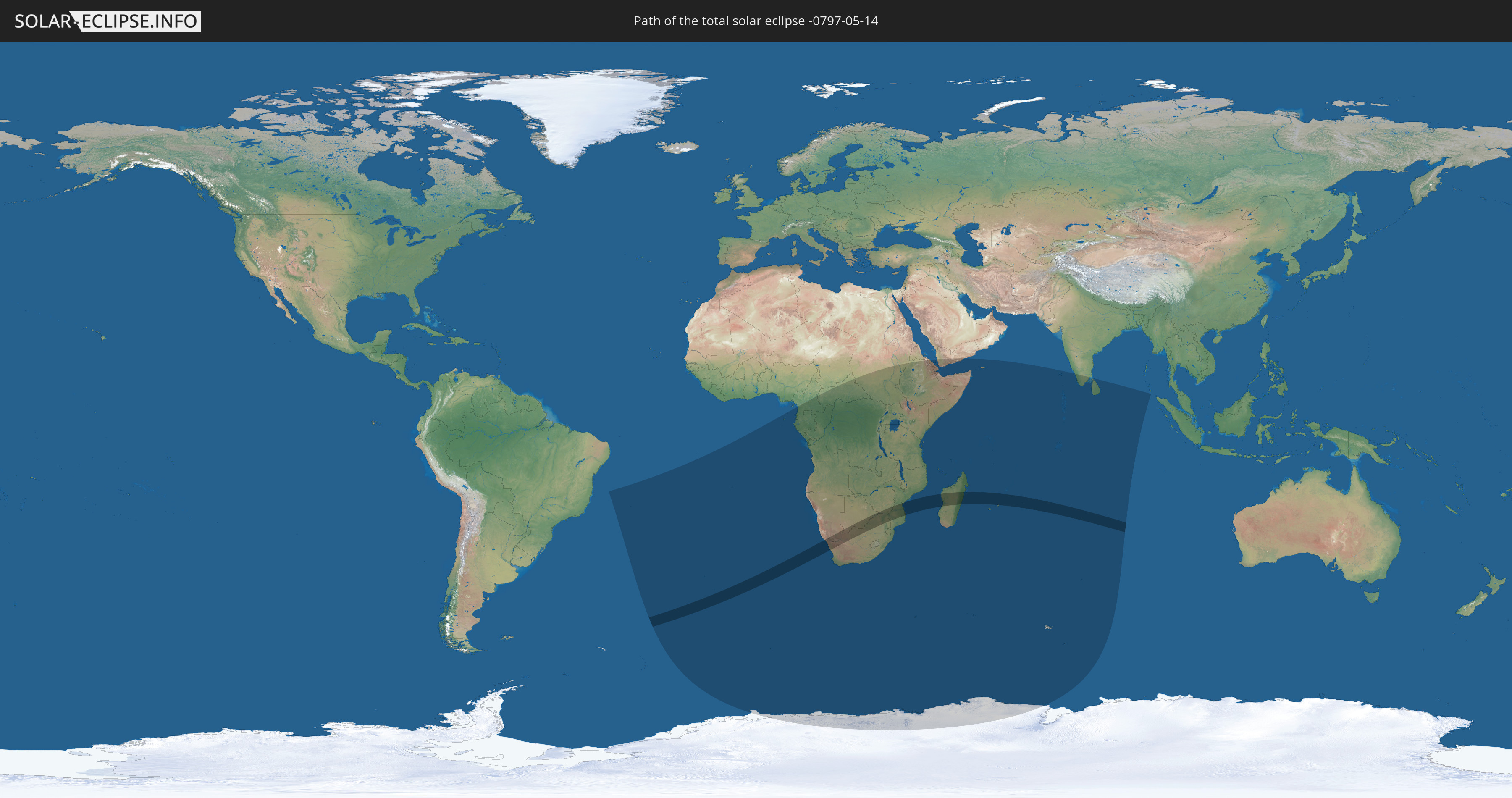
Die Sonnenfinsternis am 14.05.-0797 kann man in 44 Ländern als partielle Sonnenfinsternis beobachten.
Der Finsternispfad verläuft durch 7 Länder. Nur in diesen Ländern ist sie als totale Sonnenfinsternis zu sehen.
In den folgenden Ländern ist die Sonnenfinsternis total zu sehen
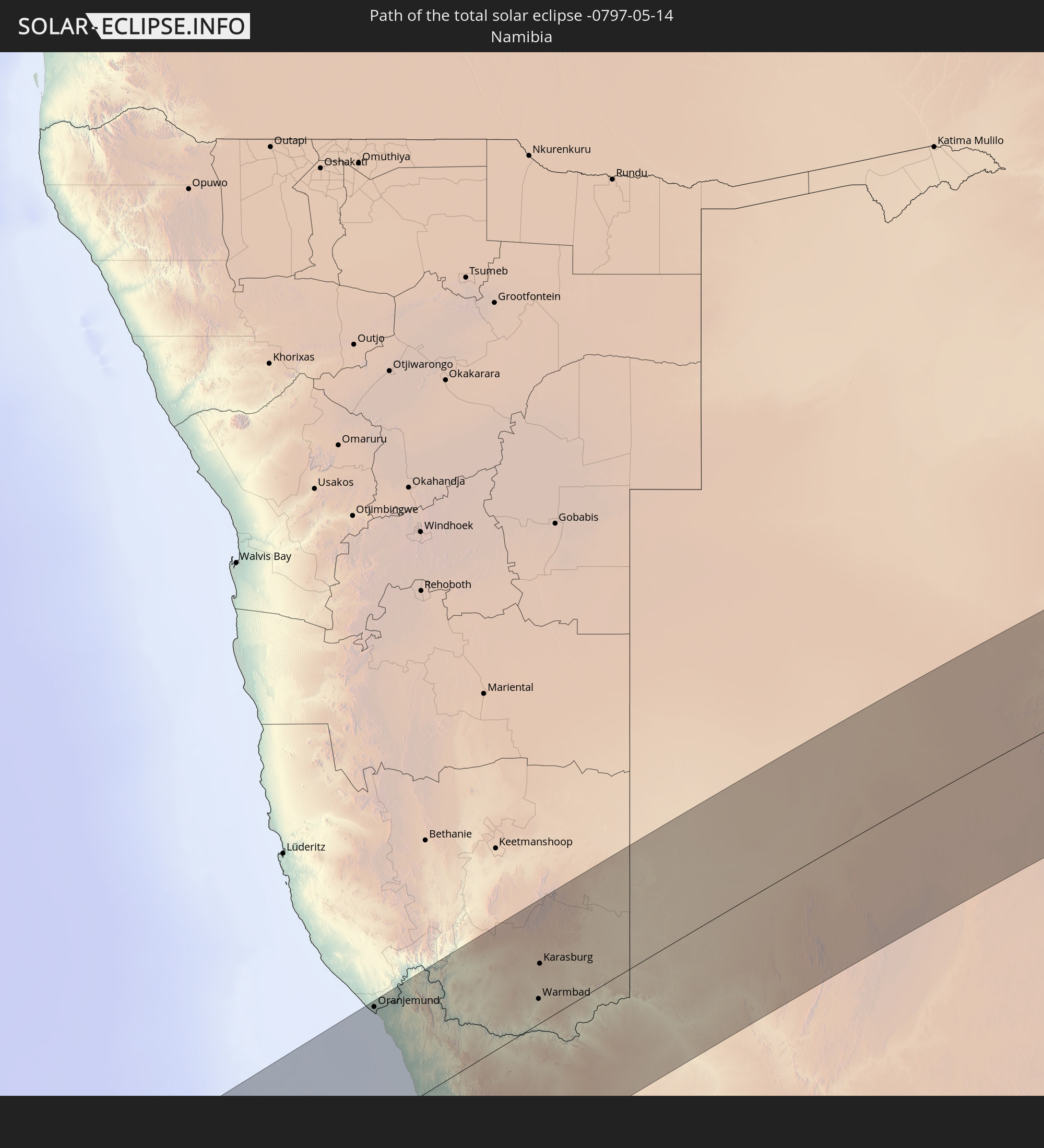 Namibia
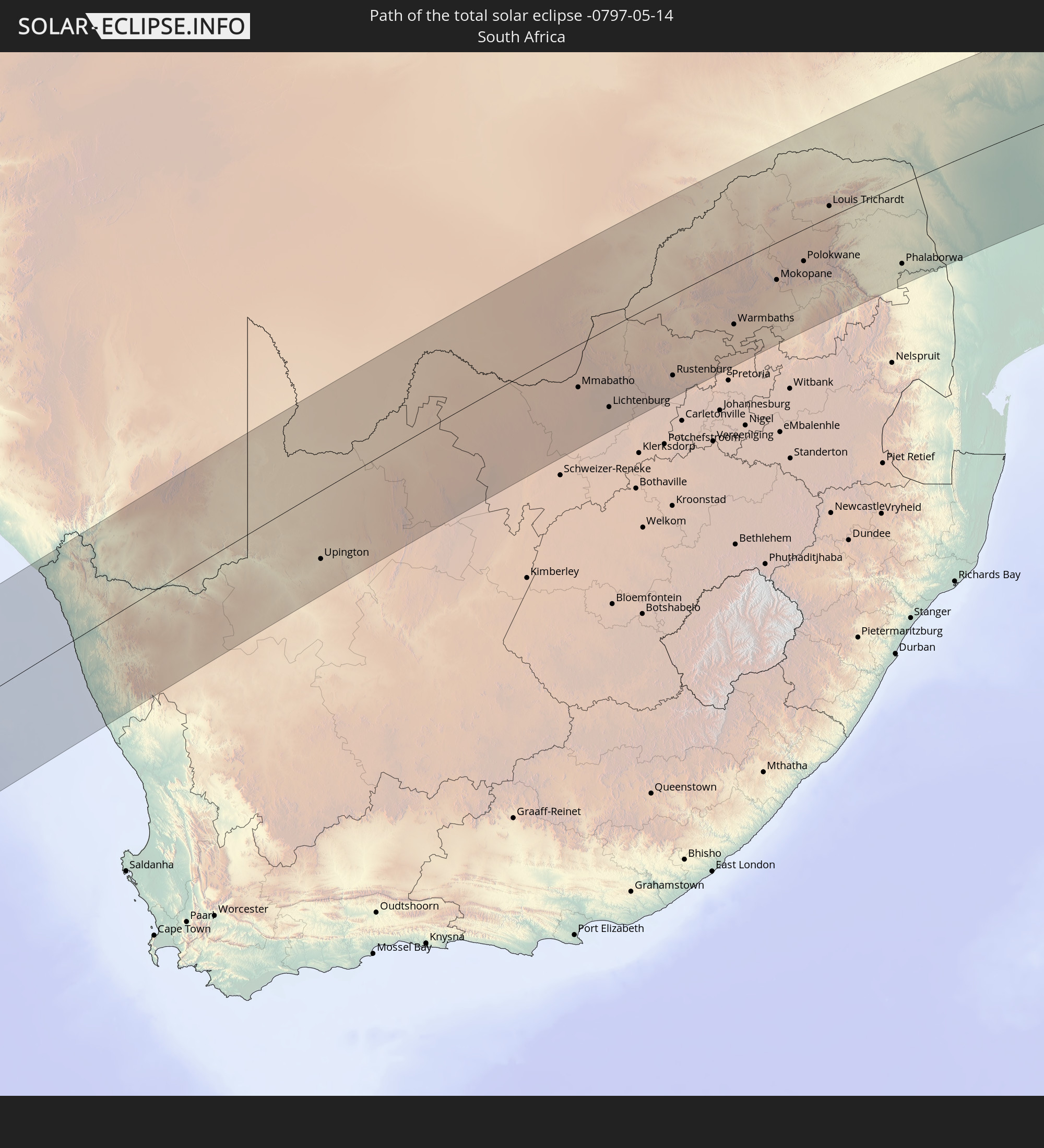 Südafrika
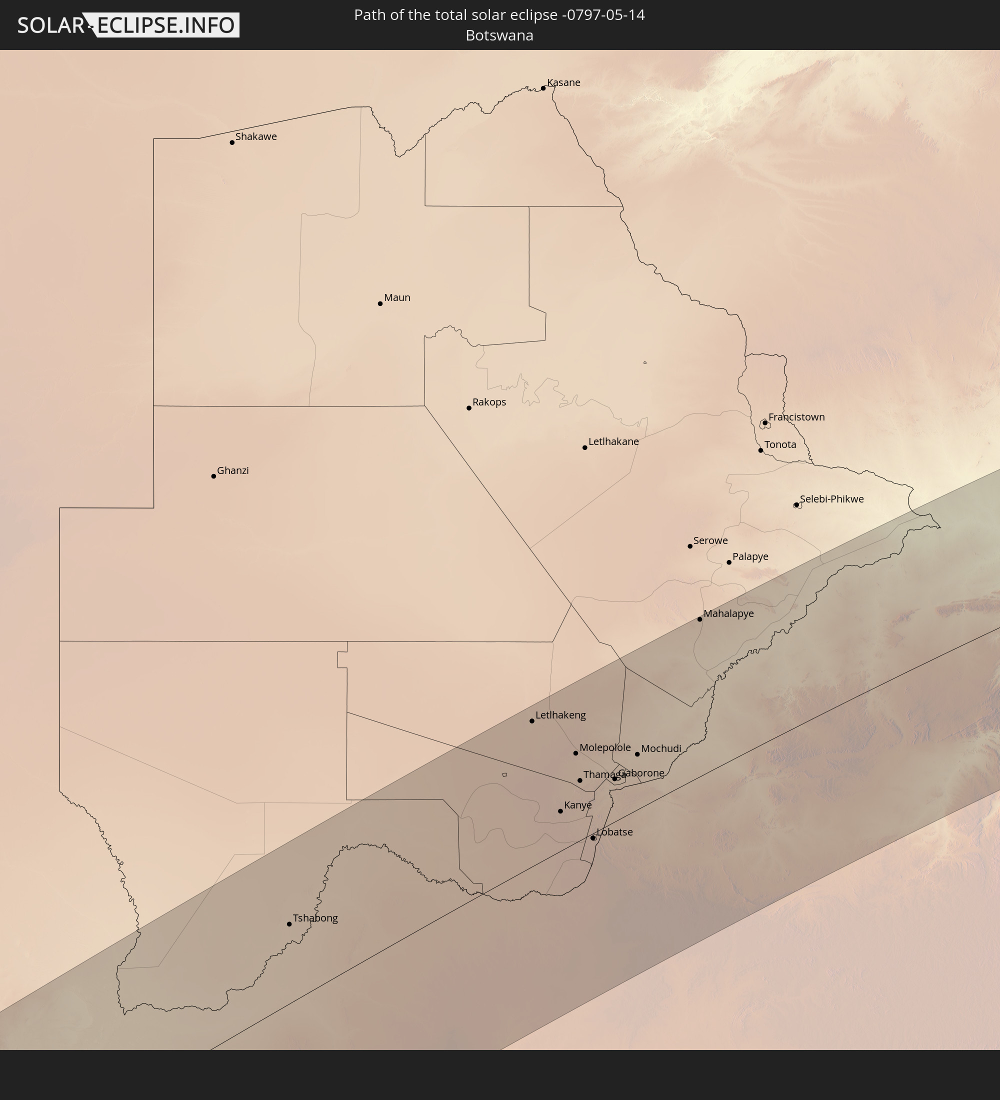 Botswana
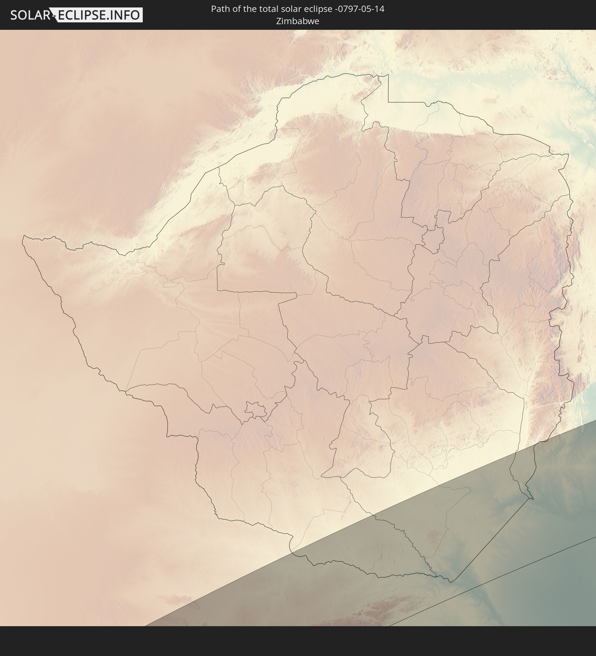 Simbabwe
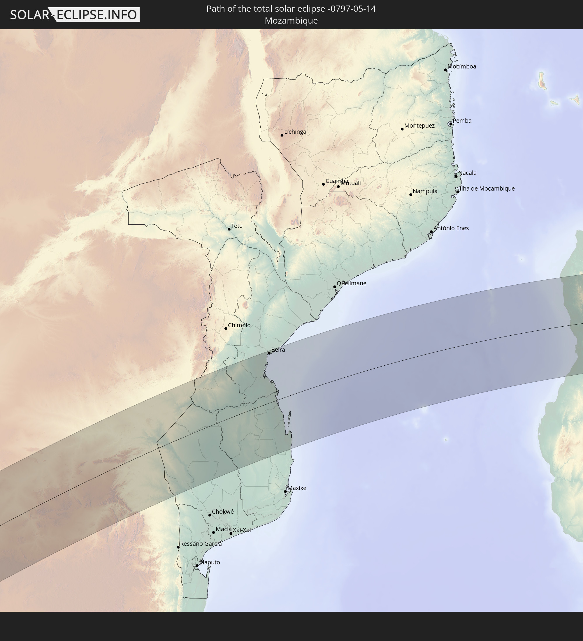 Mosambik
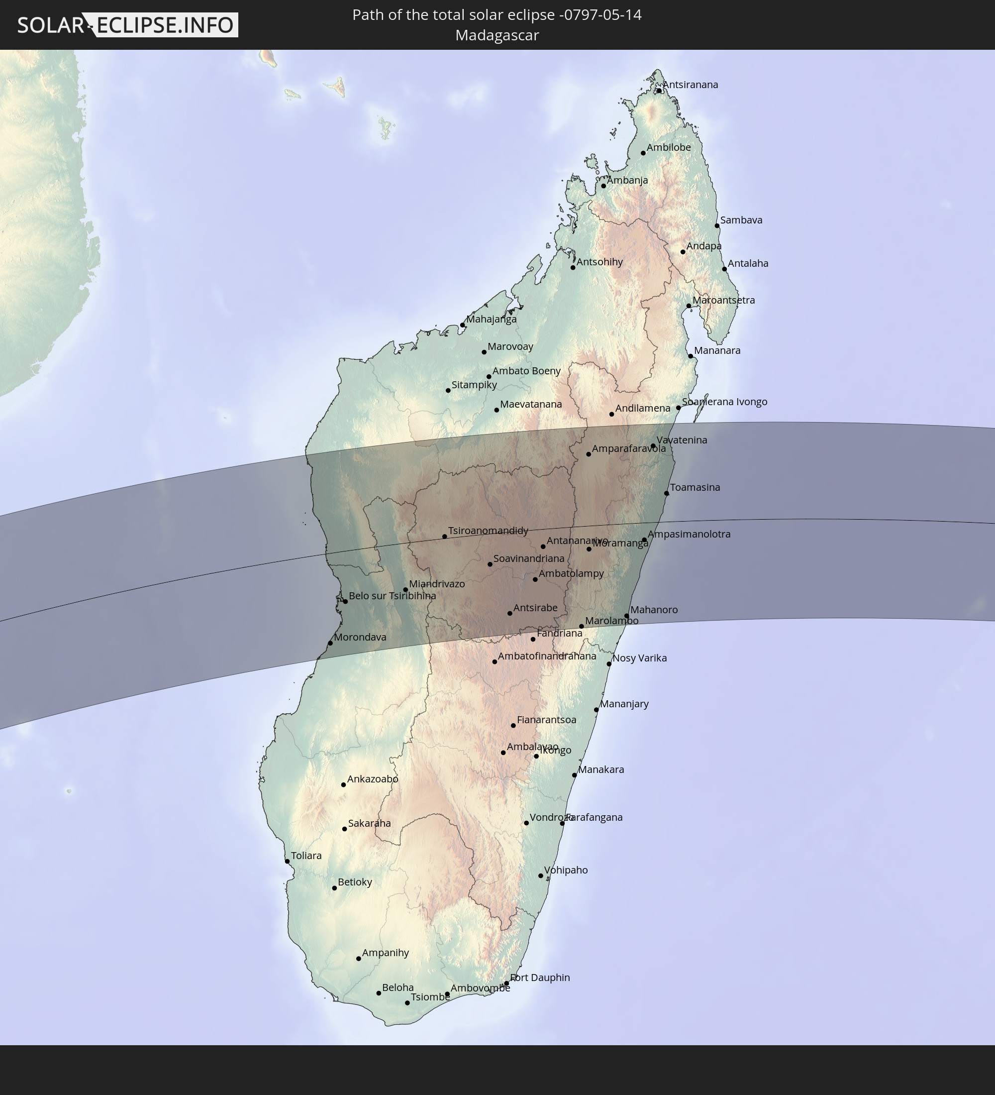 Madagaskar
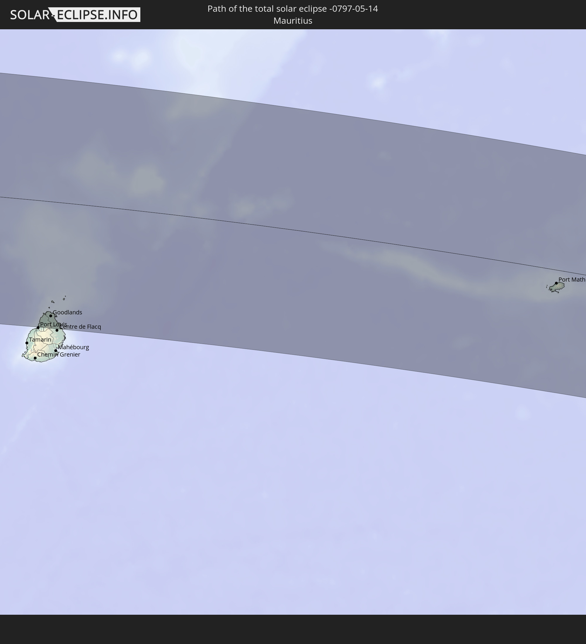 Mauritius
In den folgenden Ländern ist die Sonnenfinsternis partiell zu sehen
 Antarktika
 Brasilien
 St. Helena
 Bouvetinsel
 Äquatorialguinea
 São Tomé und Príncipe
 Kamerun
 Gabun
Gabun
 Republik Kongo
 Angola
 Namibia
 Demokratische Republik Kongo
 Zentralafrikanische Republik
 Südafrika
 Botswana
 Sudan
Sudan
 Sambia
 Simbabwe
 Lesotho
 Ruanda
 Burundi
 Tansania
 Uganda
 Mosambik
 Swasiland
 Malawi
 Äthiopien
 Kenia
Kenia
 Eritrea
 Französische Süd- und Antarktisgebiete
 Somalia
 Dschibuti
 Jemen
Jemen
 Madagaskar
 Komoren
 Mayotte
 Seychellen
 Réunion
 Mauritius
 Indien
 Britisches Territorium im Indischen Ozean
 Heard und McDonaldinseln
 Malediven
 Sri Lanka
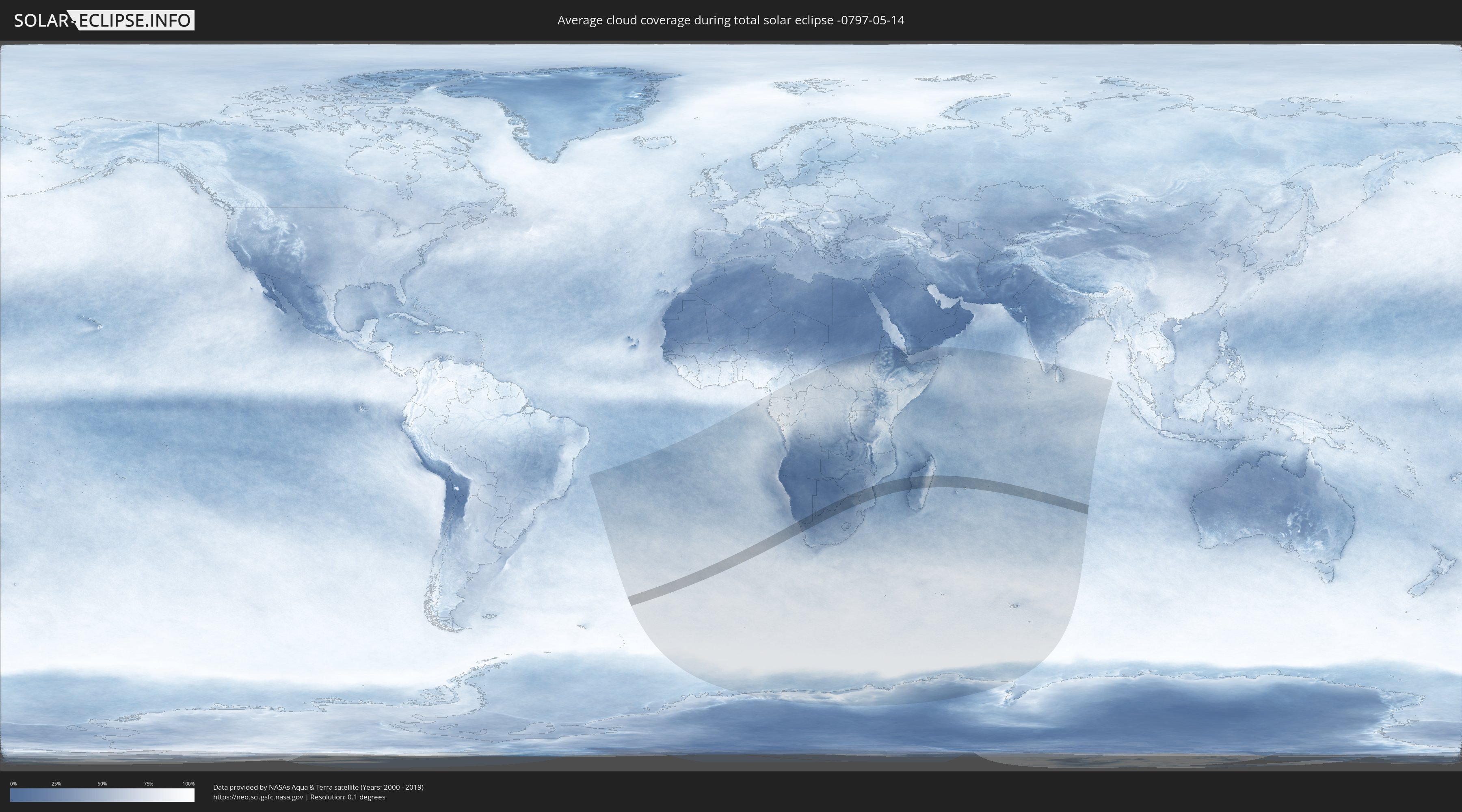
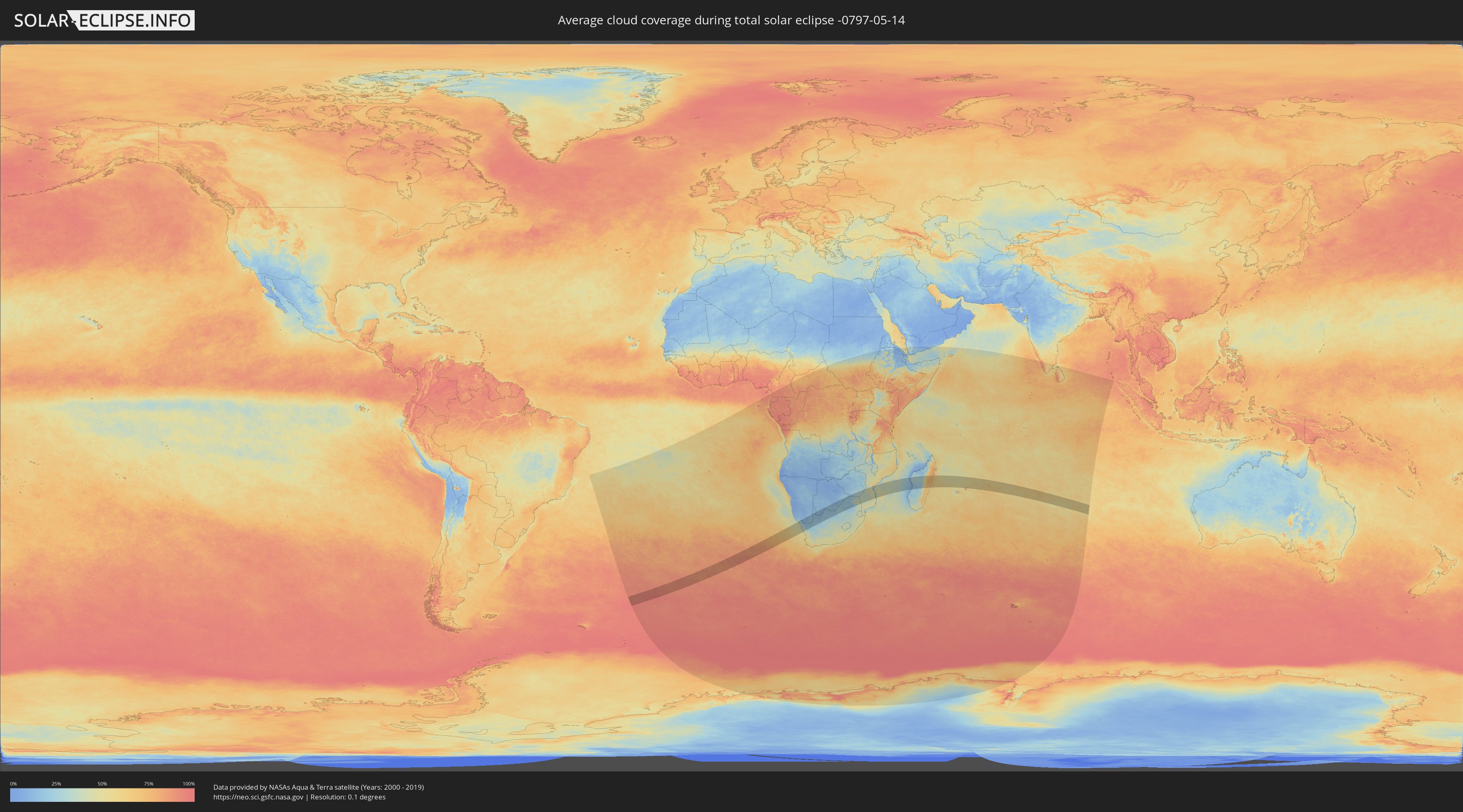
Wie wird das Wetter während der totalen Sonnenfinsternis am 14.05.-0797?
Wo ist der beste Ort, um die totale Sonnenfinsternis vom 14.05.-0797 zu beobachten?
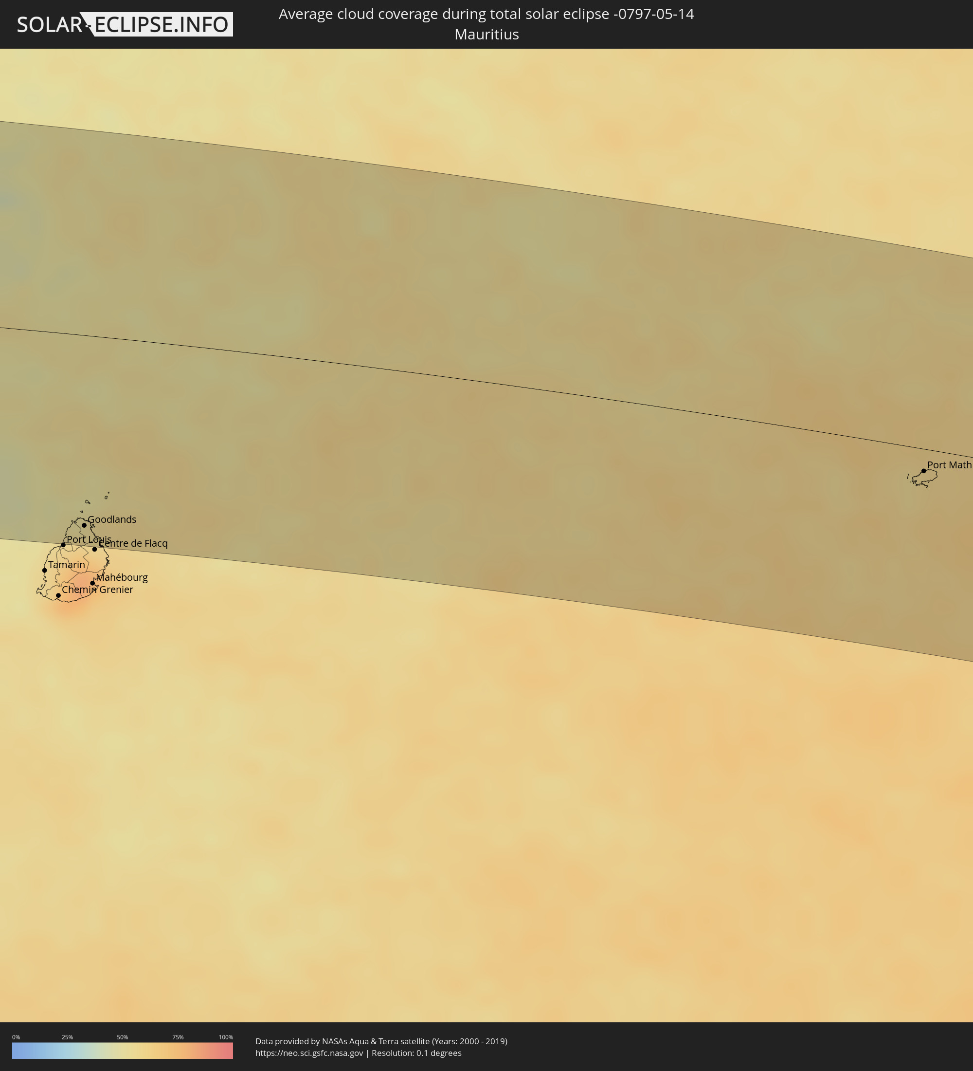
Die folgenden Karten zeigen die durchschnittliche Bewölkung für den Tag, an dem die totale Sonnenfinsternis
stattfindet. Mit Hilfe der Karten lässt sich der Ort entlang des Finsternispfades eingrenzen,
der die besten Aussichen auf einen klaren wolkenfreien Himmel bietet.
Trotzdem muss man immer lokale Gegenenheiten beachten und sollte sich genau über das Wetter an seinem
gewählten Beobachtungsort informieren.
Die Daten stammen von den beiden NASA-Satelliten
AQUA und TERRA
und wurden über einen Zeitraum von 19 Jahren (2000 - 2019) gemittelt.
Detaillierte Länderkarten
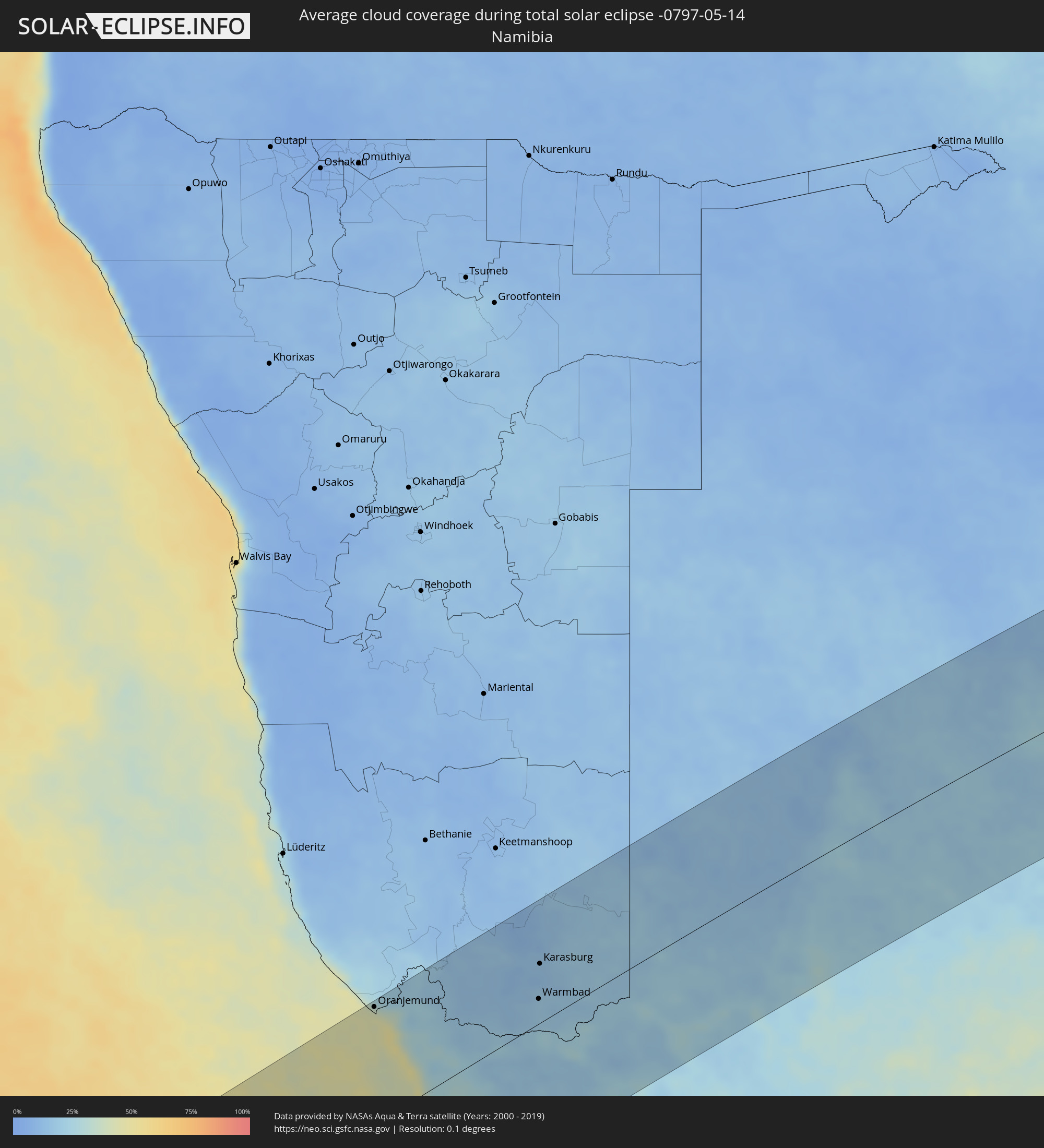 Namibia
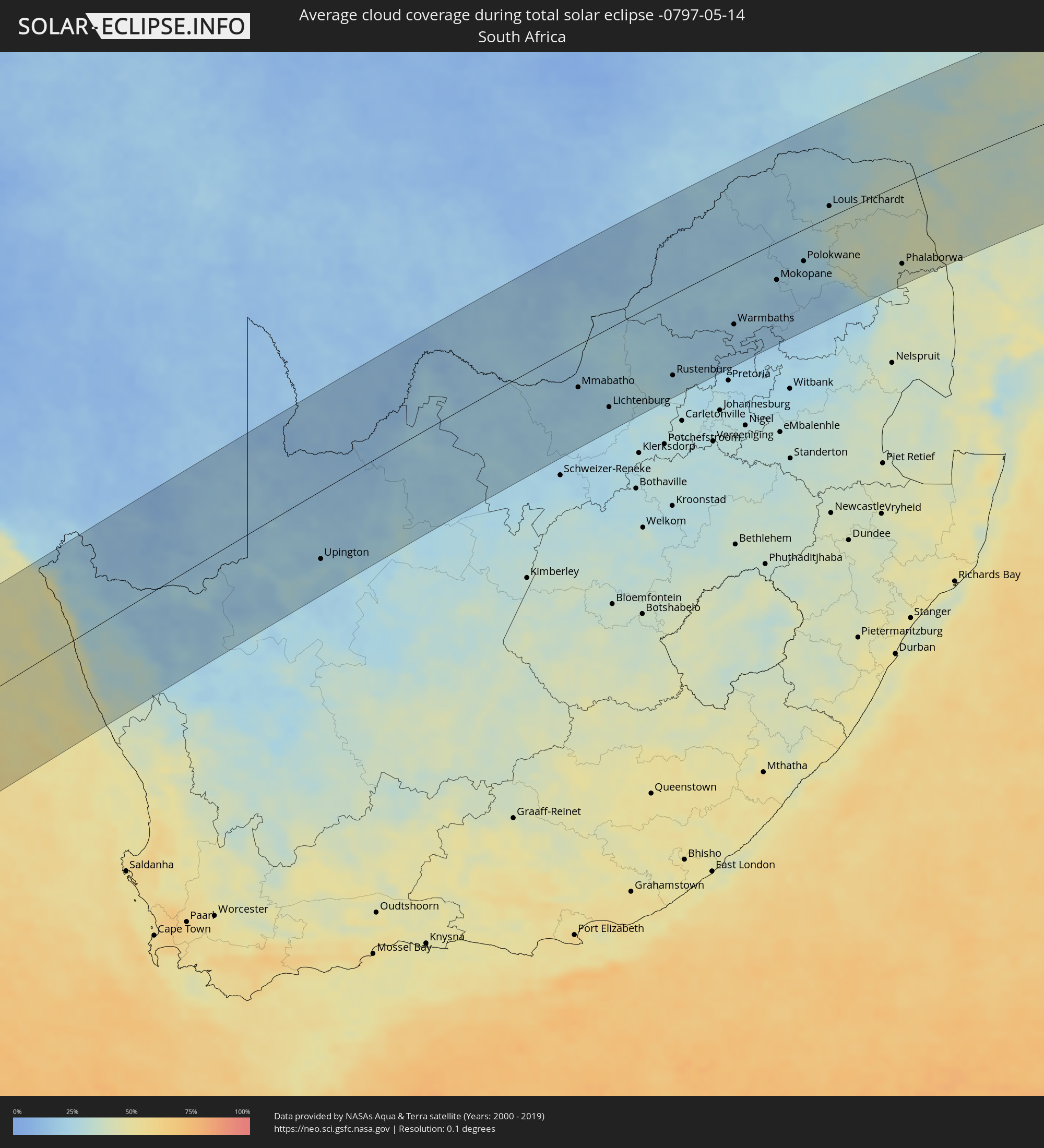 Südafrika
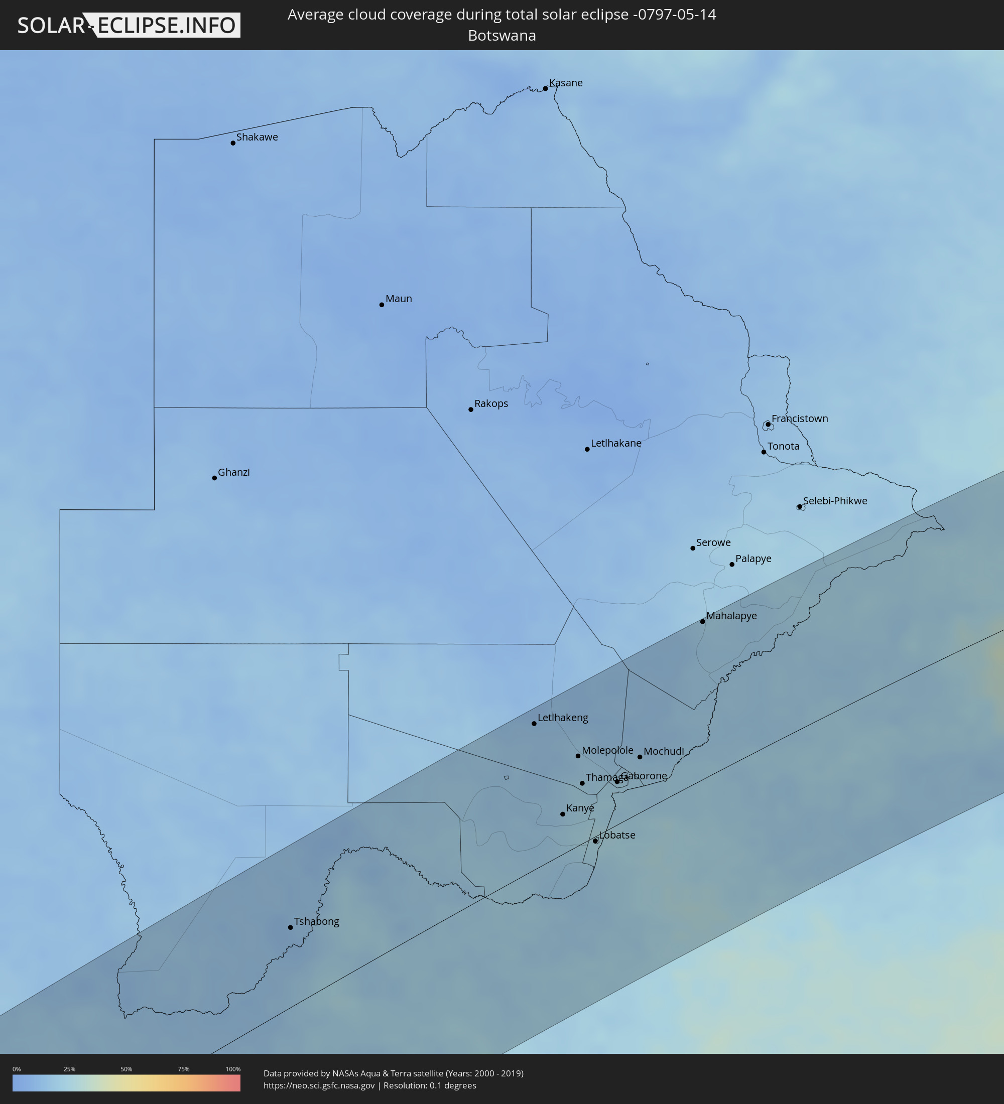 Botswana
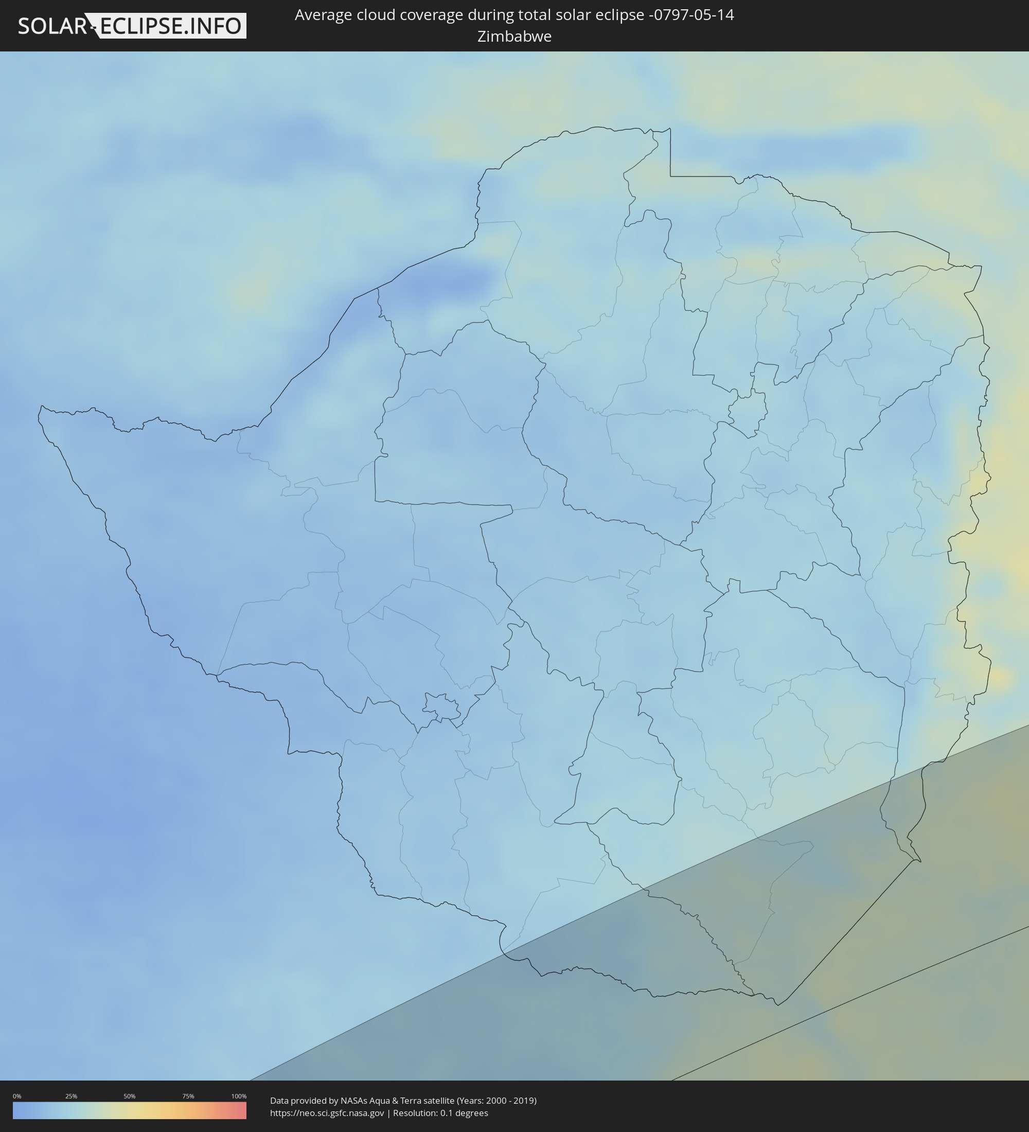 Simbabwe
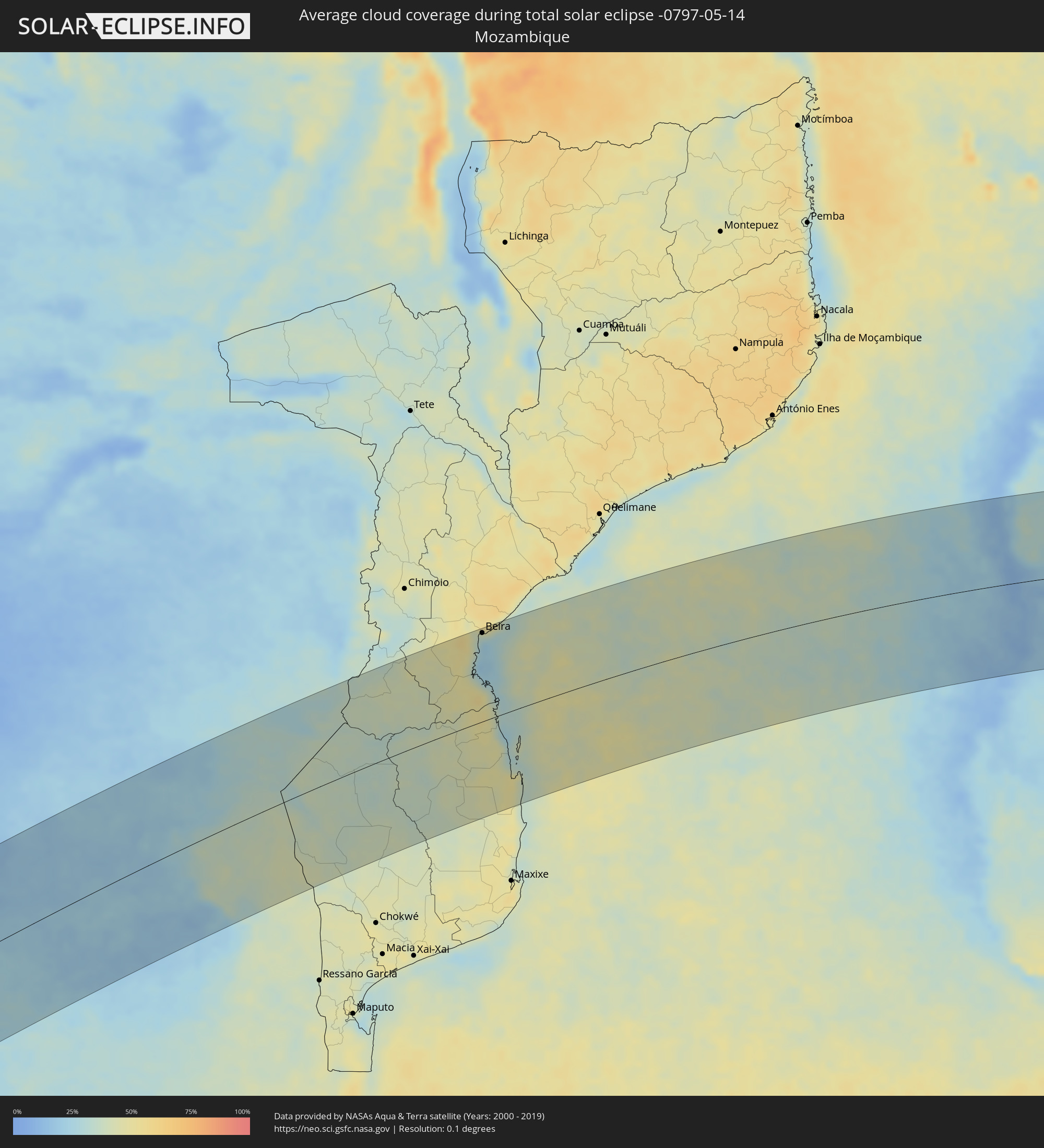 Mosambik
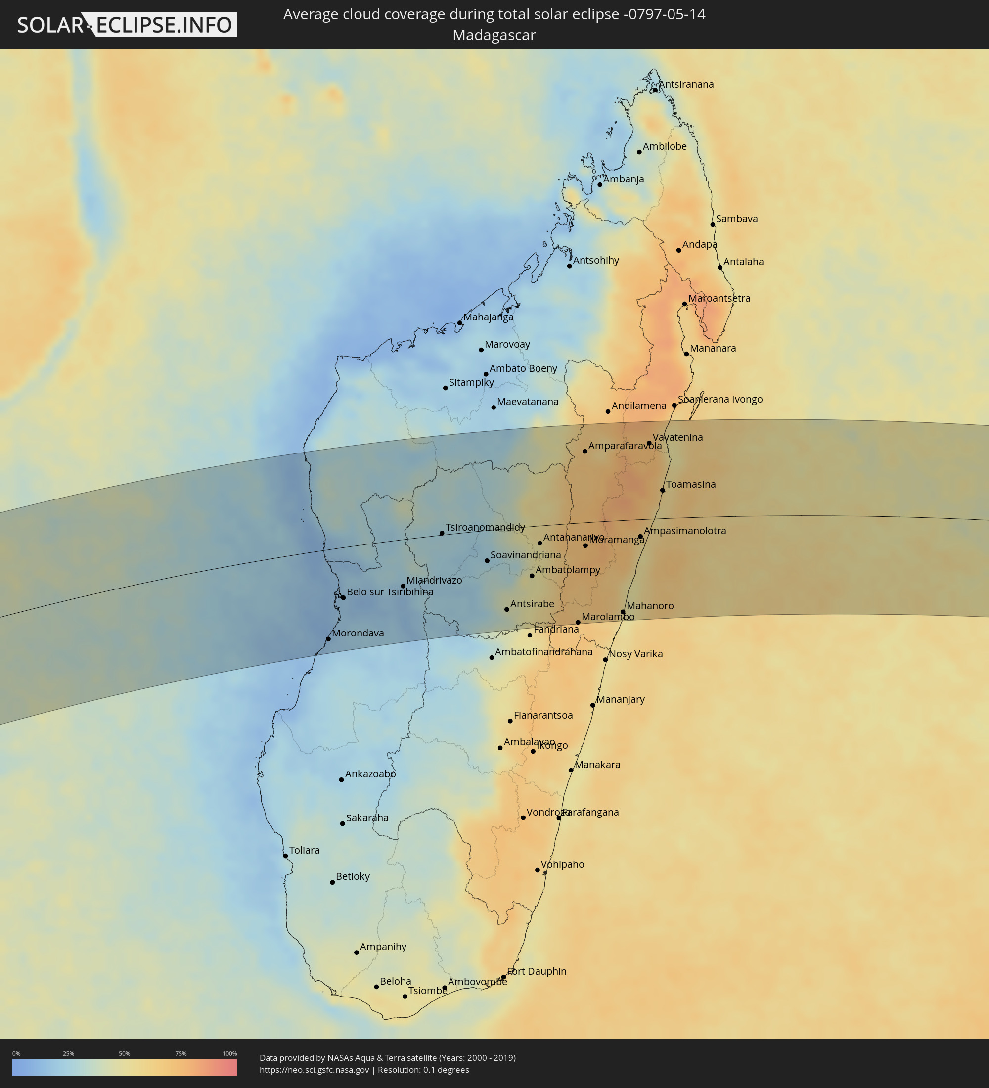 Madagaskar
 Mauritius
Orte im Finsternispfad
Die nachfolgene Tabelle zeigt Städte und Orte mit mehr als 5.000 Einwohnern, die sich im Finsternispfad befinden. Städte mit mehr als 100.000 Einwohnern sind dick gekennzeichnet. Mit einem Klick auf den Ort öffnet sich eine Detailkarte die die Lage des jeweiligen Ortes zusammen mit dem Verlauf der zentralen Finsternis präsentiert.
| Ort | Typ | Dauer der Verfinsterung | Ortszeit bei maximaler Verfinsterung | Entfernung zur Zentrallinie | Ø Bewölkung |
|
Oranjemund, Karas
|
total | - | 10:52:11 UTC+01:30 | 136 km | 45% |
|
Springbok, Northern Cape
|
total | - | 10:54:44 UTC+01:30 | 43 km | 28% |
|
Warmbad, Karas
|
total | - | 10:56:52 UTC+01:30 | 29 km | 19% |
|
Karasburg, Karas
|
total | - | 10:57:04 UTC+01:30 | 70 km | 16% |
|
Upington, Northern Cape
|
total | - | 11:02:14 UTC+01:30 | 98 km | 24% |
|
Tshabong, Kgalagadi
|
total | - | 11:46:24 UTC+02:10 | 72 km | 12% |
|
Kathu, Northern Cape
|
total | - | 11:06:34 UTC+01:30 | 116 km | 23% |
|
Kuruman, Northern Cape
|
total | - | 11:07:33 UTC+01:30 | 112 km | 22% |
|
Vryburg, North-West
|
total | - | 11:10:49 UTC+01:30 | 128 km | 21% |
|
Letlhakeng, Kweneng
|
total | - | 11:53:40 UTC+02:10 | 137 km | 16% |
|
Kanye, Ngwaketsi
|
total | - | 11:53:49 UTC+02:10 | 37 km | 21% |
|
Mosopa, Ngwaketsi
|
total | - | 11:54:09 UTC+02:10 | 52 km | 21% |
|
Molepolole, Kweneng
|
total | - | 11:54:35 UTC+02:10 | 84 km | 20% |
|
Thamaga, Kweneng
|
total | - | 11:54:31 UTC+02:10 | 56 km | 23% |
|
Janeng, South-East
|
total | - | 11:54:03 UTC+02:10 | 18 km | 19% |
|
Mmabatho, North-West
|
total | - | 11:13:38 UTC+01:30 | 64 km | 20% |
|
Mahikeng, North-West
|
total | - | 11:13:39 UTC+01:30 | 66 km | 20% |
|
Lobatse, South-East
|
total | - | 11:54:29 UTC+02:10 | 5 km | 25% |
|
Otse, South-East
|
total | - | 11:54:45 UTC+02:10 | 13 km | 26% |
|
Gabane, Kweneng
|
total | - | 11:55:06 UTC+02:10 | 45 km | 23% |
|
Metsemotlhaba, Kweneng
|
total | - | 11:55:14 UTC+02:10 | 55 km | 22% |
|
Mogoditshane, Kweneng
|
total | - | 11:55:20 UTC+02:10 | 45 km | 22% |
|
Ramotswa, South-East
|
total | - | 11:55:11 UTC+02:10 | 20 km | 23% |
|
Kopong, South-East
|
total | - | 11:55:28 UTC+02:10 | 58 km | 21% |
|
Gaborone, South-East
|
total | - | 11:55:25 UTC+02:10 | 40 km | 22% |
|
Zeerust, North-West
|
total | - | 11:14:54 UTC+01:30 | 55 km | 25% |
|
Mochudi, Kgatleng
|
total | - | 11:56:10 UTC+02:10 | 52 km | 19% |
|
Lichtenburg, North-West
|
total | - | 11:14:43 UTC+01:30 | 119 km | 23% |
|
Mahalapye, Central
|
total | - | 11:58:45 UTC+02:10 | 150 km | 20% |
|
Koster, North-West
|
total | - | 11:16:41 UTC+01:30 | 126 km | 25% |
|
Rustenburg, North-West
|
total | - | 11:17:39 UTC+01:30 | 123 km | 24% |
|
Thabazimbi, Limpopo
|
total | - | 11:18:49 UTC+01:30 | 25 km | 20% |
|
Brits, North-West
|
total | - | 11:19:00 UTC+01:30 | 145 km | 23% |
|
Ga-Rankuwa, North-West
|
total | - | 11:19:33 UTC+01:30 | 153 km | 23% |
|
Mabopane, Gauteng
|
total | - | 11:19:54 UTC+01:30 | 146 km | 20% |
|
Warmbaths, Limpopo
|
total | - | 11:20:47 UTC+01:30 | 94 km | 19% |
|
Modimolle, Limpopo
|
total | - | 11:21:13 UTC+01:30 | 81 km | 22% |
|
Mokopane, Limpopo
|
total | - | 11:23:07 UTC+01:30 | 58 km | 21% |
|
Siyabuswa, Mpumalanga
|
total | - | 11:22:31 UTC+01:30 | 151 km | 17% |
|
Polokwane, Limpopo
|
total | - | 11:24:31 UTC+01:30 | 50 km | 22% |
|
Lebowakgomo, Limpopo
|
total | - | 11:24:22 UTC+01:30 | 81 km | 21% |
|
Mankoeng, Limpopo
|
total | - | 11:25:24 UTC+01:30 | 65 km | 25% |
|
Louis Trichardt, Limpopo
|
total | - | 11:26:18 UTC+01:30 | 17 km | 31% |
|
Duiwelskloof, Limpopo
|
total | - | 11:26:24 UTC+01:30 | 58 km | 34% |
|
Tzaneen, Limpopo
|
total | - | 11:26:21 UTC+01:30 | 73 km | 37% |
|
Ga-Kgapane, Limpopo
|
total | - | 11:26:39 UTC+01:30 | 57 km | 38% |
|
Nkowakowa, Limpopo
|
total | - | 11:26:37 UTC+01:30 | 84 km | 37% |
|
Thohoyandou, Limpopo
|
total | - | 11:27:53 UTC+01:30 | 2 km | 37% |
|
Giyani, Limpopo
|
total | - | 11:28:12 UTC+01:30 | 44 km | 38% |
|
Phalaborwa, Limpopo
|
total | - | 11:28:46 UTC+01:30 | 127 km | 39% |
|
Beira, Sofala
|
total | - | 12:22:28 UTC+02:10 | 152 km | 35% |
|
Maintirano, Melaky
|
total | - | 13:05:13 UTC+02:27 | 107 km | 14% |
|
Morondava, Menabe
|
total | - | 13:03:42 UTC+02:27 | 142 km | 16% |
|
Belo sur Tsiribihina, Menabe
|
total | - | 13:04:51 UTC+02:27 | 81 km | 17% |
|
Miandrivazo, Menabe
|
total | - | 13:07:15 UTC+02:27 | 75 km | 19% |
|
Tsiroanomandidy, Bongolava
|
total | - | 13:09:27 UTC+02:27 | 2 km | 27% |
|
Fenoarivo Be, Bongolava
|
total | - | 13:11:02 UTC+02:27 | 33 km | 26% |
|
Soavinandriana, Itasy
|
total | - | 13:10:42 UTC+02:27 | 49 km | 29% |
|
Miandrarivo, Vakinankaratra
|
total | - | 13:10:28 UTC+02:27 | 79 km | 32% |
|
Betafo, Vakinankaratra
|
total | - | 13:10:18 UTC+02:27 | 125 km | 32% |
|
Faratsiho, Vakinankaratra
|
total | - | 13:10:58 UTC+02:27 | 77 km | 33% |
|
Antsirabe, Vakinankaratra
|
total | - | 13:10:42 UTC+02:27 | 130 km | 37% |
|
Ankazobe, Analamanga
|
total | - | 13:12:27 UTC+02:27 | 41 km | 36% |
|
Arivonimamo, Itasy
|
total | - | 13:11:55 UTC+02:27 | 37 km | 33% |
|
Soanindrariny, Vakinankaratra
|
total | - | 13:11:08 UTC+02:27 | 136 km | 42% |
|
Antanifotsy, Vakinankaratra
|
total | - | 13:11:35 UTC+02:27 | 109 km | 47% |
|
Ambatolampy, Vakinankaratra
|
total | - | 13:12:05 UTC+02:27 | 80 km | 48% |
|
Antananarivo, Analamanga
|
total | - | 13:12:50 UTC+02:27 | 29 km | 49% |
|
Ambohitrolomahitsy, Analamanga
|
total | - | 13:13:24 UTC+02:27 | 6 km | 59% |
|
Sadabe, Analamanga
|
total | - | 13:13:30 UTC+02:27 | 1 km | 59% |
|
Alarobia, Analamanga
|
total | - | 13:13:15 UTC+02:27 | 36 km | 56% |
|
Ankazondandy, Analamanga
|
total | - | 13:13:38 UTC+02:27 | 7 km | 66% |
|
Manjakandriana, Analamanga
|
total | - | 13:13:27 UTC+02:27 | 31 km | 63% |
|
Anjozorobe, Analamanga
|
total | - | 13:14:07 UTC+02:27 | 26 km | 66% |
|
Marolambo, Atsinanana
|
total | - | 13:13:02 UTC+02:27 | 160 km | 68% |
|
Amparafaravola, Alaotra Mangoro
|
total | - | 13:15:45 UTC+02:27 | 113 km | 68% |
|
Moramanga, Alaotra Mangoro
|
total | - | 13:14:25 UTC+02:27 | 38 km | 72% |
|
Ambatondrazaka, Alaotra Mangoro
|
total | - | 13:15:57 UTC+02:27 | 85 km | 69% |
|
Mahanoro, Atsinanana
|
total | - | 13:14:45 UTC+02:27 | 147 km | 51% |
|
Vohibinany, Atsinanana
|
total | - | 13:17:49 UTC+02:27 | 135 km | 73% |
|
Ampasimanolotra, Atsinanana
|
total | - | 13:16:27 UTC+02:27 | 28 km | 56% |
|
Andovoranto, Atsinanana
|
total | - | 13:16:25 UTC+02:27 | 44 km | 51% |
|
Vavatenina, Analanjirofo
|
total | - | 13:18:05 UTC+02:27 | 121 km | 74% |
|
Toamasina, Atsinanana
|
total | - | 13:17:52 UTC+02:27 | 44 km | 58% |
|
Fenoarivo Atsinanana, Analanjirofo
|
total | - | 13:18:38 UTC+02:27 | 130 km | 60% |
|
Grande Pointe aux Piments, Pamplemousses
|
total | - | 14:54:57 UTC+03:50 | 141 km | 64% |
|
Le Hochet, Pamplemousses
|
total | - | 14:54:54 UTC+03:50 | 149 km | 64% |
|
Terre Rouge, Pamplemousses
|
total | - | 14:54:55 UTC+03:50 | 148 km | 64% |
|
Triolet, Pamplemousses
|
total | - | 14:55:01 UTC+03:50 | 140 km | 64% |
|
Morcellemont Saint André, Pamplemousses
|
total | - | 14:55:01 UTC+03:50 | 142 km | 72% |
|
Long Mountain, Pamplemousses
|
total | - | 14:54:58 UTC+03:50 | 150 km | 72% |
|
Pamplemousses, Pamplemousses
|
total | - | 14:55:01 UTC+03:50 | 145 km | 72% |
|
Plaine des Papayes, Pamplemousses
|
total | - | 14:55:03 UTC+03:50 | 141 km | 72% |
|
Fond du Sac, Pamplemousses
|
total | - | 14:55:05 UTC+03:50 | 138 km | 61% |
|
Grand Baie, Rivière du Rempart
|
total | - | 14:55:07 UTC+03:50 | 136 km | 61% |
|
Petit Raffray, Rivière du Rempart
|
total | - | 14:55:11 UTC+03:50 | 135 km | 61% |
|
Piton, Rivière du Rempart
|
total | - | 14:55:08 UTC+03:50 | 143 km | 72% |
|
Goodlands, Rivière du Rempart
|
total | - | 14:55:13 UTC+03:50 | 137 km | 61% |
|
Grand Gaube, Rivière du Rempart
|
total | - | 14:55:16 UTC+03:50 | 133 km | 58% |
|
Laventure, Flacq
|
total | - | 14:55:09 UTC+03:50 | 149 km | 68% |
|
Rivière du Rempart, Rivière du Rempart
|
total | - | 14:55:13 UTC+03:50 | 144 km | 68% |
|
Roches Noire, Rivière du Rempart
|
total | - | 14:55:15 UTC+03:50 | 145 km | 68% |
|
Poste de Flacq, Flacq
|
total | - | 14:55:14 UTC+03:50 | 150 km | 77% |
|
Port Mathurin, Rodrigues
|
total | - | 15:04:41 UTC+03:50 | 16 km | 58% |