Total solar eclipse of 01/30/-0904
| Day of week: | Tuesday |
| Maximum duration of eclipse: | 01m23s |
| Maximum width of eclipse path: | 154 km |
| Saros cycle: | 26 |
| Coverage: | 100% |
| Magnitude: | 1.0169 |
| Gamma: | 0.9253 |
Wo kann man die Sonnenfinsternis vom 01/30/-0904 sehen?
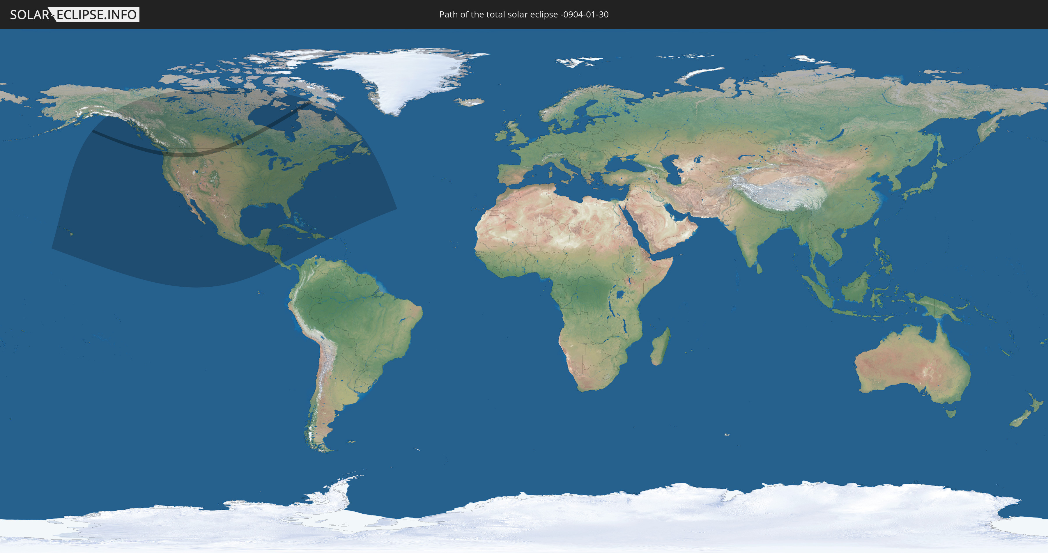
Die Sonnenfinsternis am 01/30/-0904 kann man in 22 Ländern als partielle Sonnenfinsternis beobachten.
Der Finsternispfad verläuft durch 2 Länder. Nur in diesen Ländern ist sie als total Sonnenfinsternis zu sehen.
In den folgenden Ländern ist die Sonnenfinsternis total zu sehen
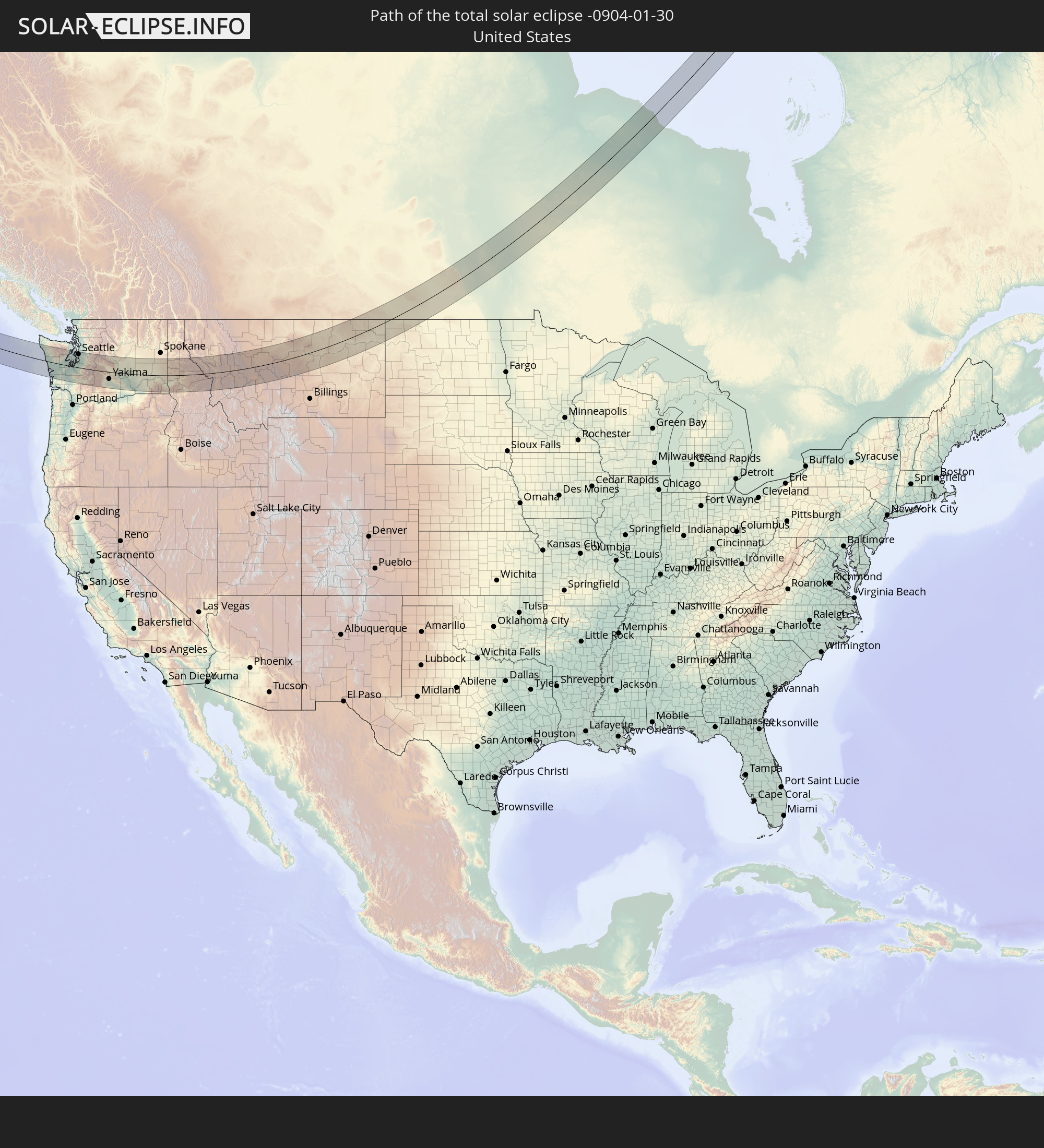 United States
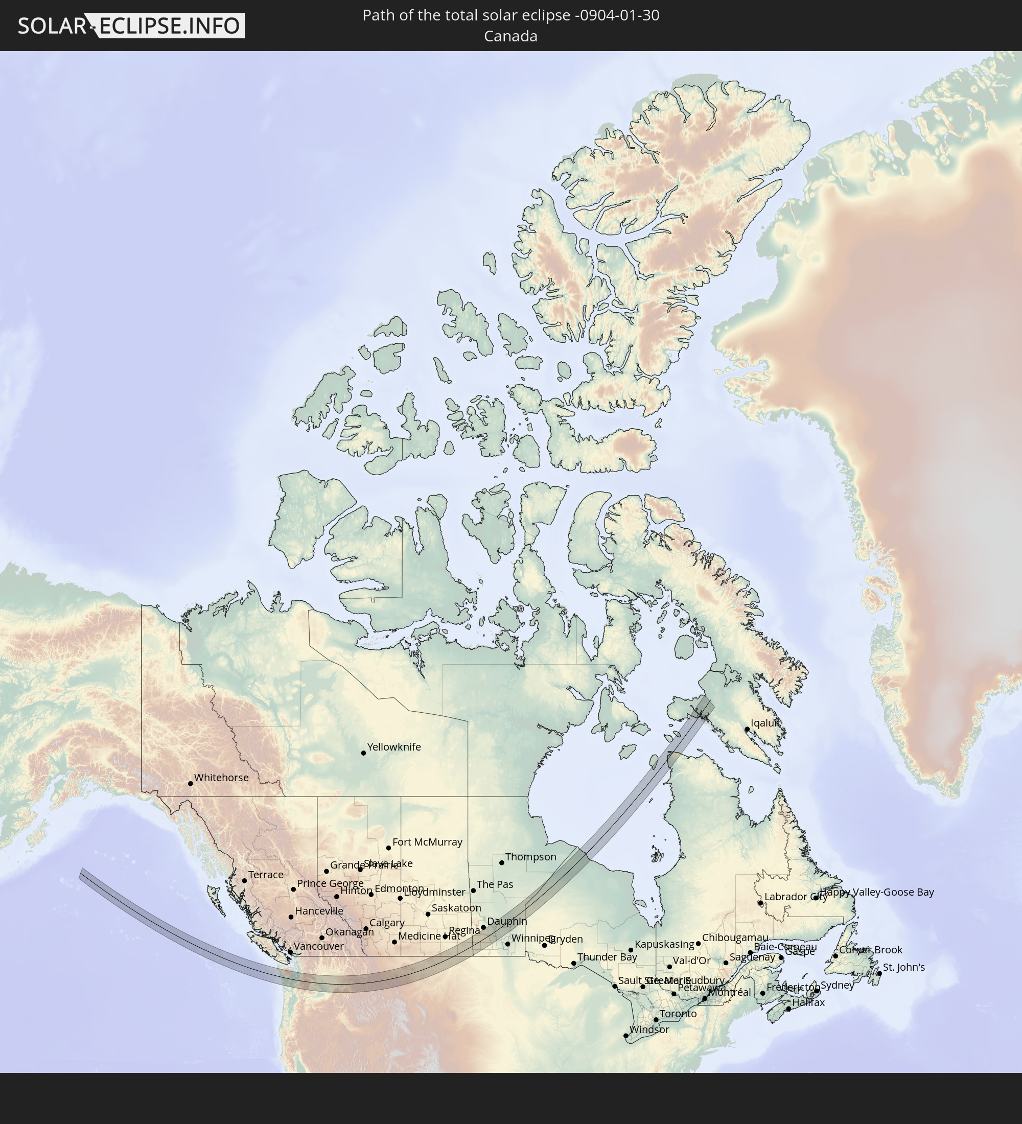 Canada
In den folgenden Ländern ist die Sonnenfinsternis partiell zu sehen


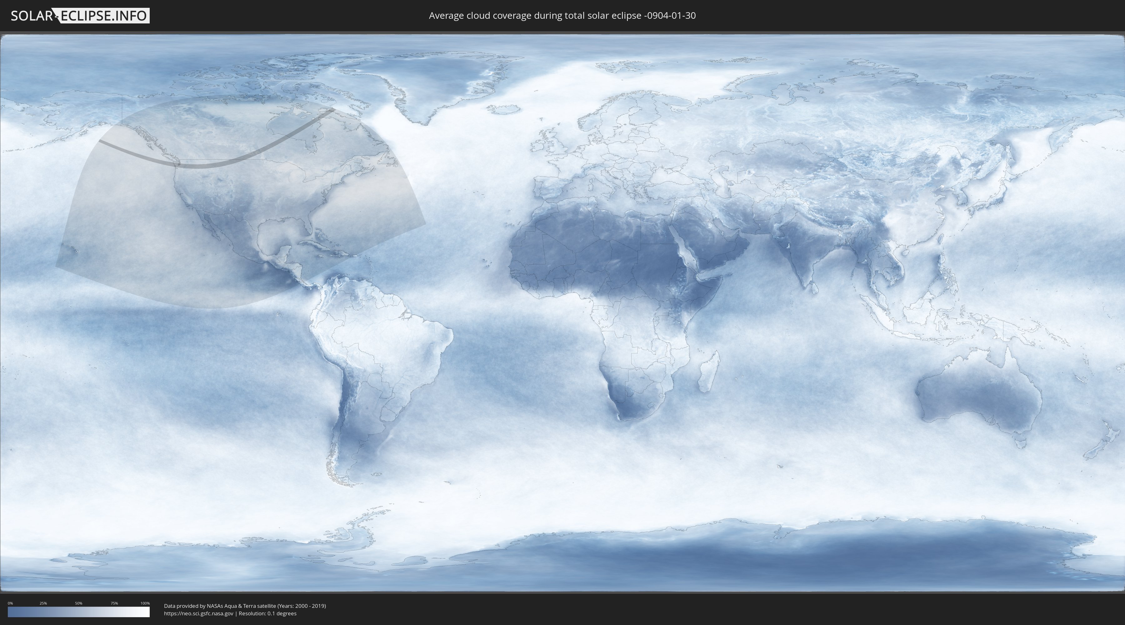
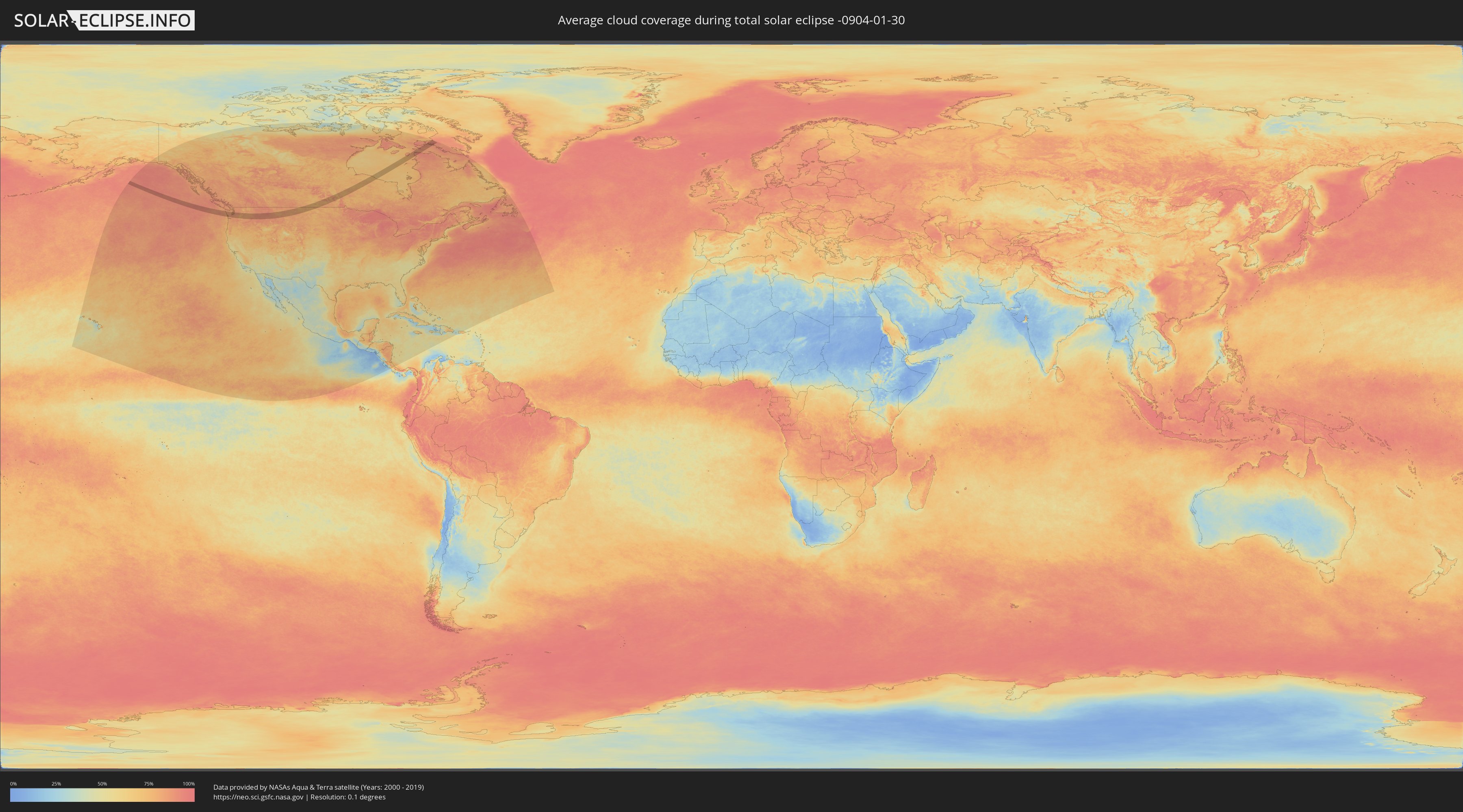
How will be the weather during the total solar eclipse on 01/30/-0904?
Where is the best place to see the total solar eclipse of 01/30/-0904?
The following maps show the average cloud coverage for the day of the total solar eclipse.
With the help of these maps, it is possible to find the place along the eclipse path, which has the best
chance of a cloudless sky.
Nevertheless, you should consider local circumstances and inform about the weather of your chosen
observation site.
The data is provided by NASAs satellites
AQUA and TERRA.
The cloud maps are averaged over a period of 19 years (2000 - 2019).
Detailed country maps
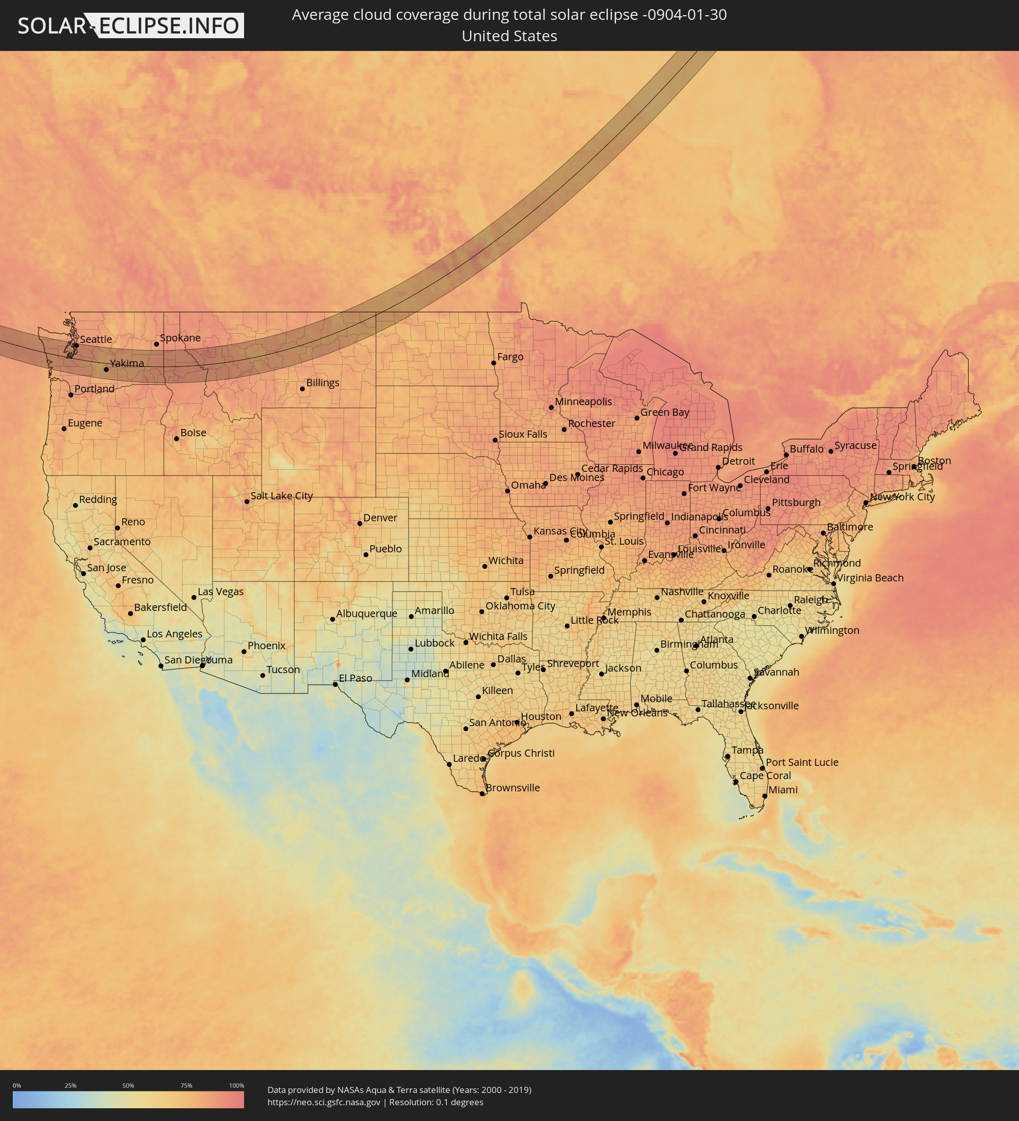 United States
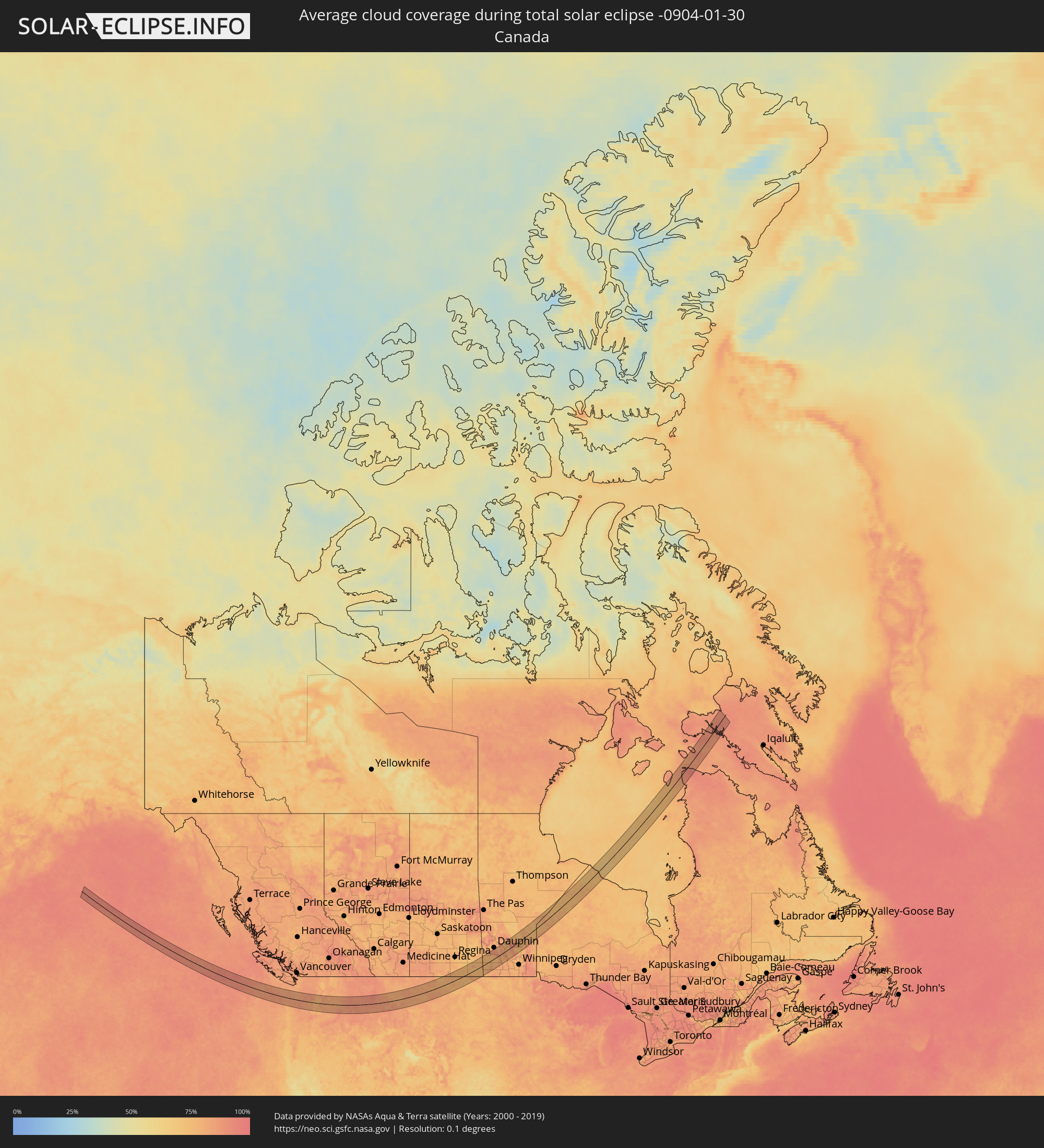 Canada
Cities inside the path of the eclipse
The following table shows all locations with a population of more than 5,000 inside the eclipse path. Cities which have more than 100,000 inhabitants are marked bold. A click at the locations opens a detailed map.
| City | Type | Eclipse duration | Local time of max. eclipse | Distance to central line | Ø Cloud coverage |
 Hoquiam, Washington
|
total | - | 10:34:04 UTC-08:00 | 32 km | 83% |
|
Aberdeen, Washington
|
total | - | 10:34:10 UTC-08:00 | 32 km | 83% |
|
Shelton, Washington
|
total | - | 10:35:32 UTC-08:00 | 6 km | 86% |
|
Chehalis, Washington
|
total | - | 10:35:11 UTC-08:00 | 53 km | 83% |
|
Centralia, Washington
|
total | - | 10:35:15 UTC-08:00 | 47 km | 83% |
|
Tumwater, Washington
|
total | - | 10:35:37 UTC-08:00 | 14 km | 86% |
|
Olympia, Washington
|
total | - | 10:35:40 UTC-08:00 | 11 km | 86% |
|
Bangor Trident Base, Washington
|
total | - | 10:36:38 UTC-08:00 | 67 km | 83% |
|
Silverdale, Washington
|
total | - | 10:36:35 UTC-08:00 | 58 km | 81% |
|
Poulsbo, Washington
|
total | - | 10:36:45 UTC-08:00 | 69 km | 83% |
|
Port Orchard, Washington
|
total | - | 10:36:35 UTC-08:00 | 48 km | 83% |
|
Bremerton, Washington
|
total | - | 10:36:37 UTC-08:00 | 51 km | 82% |
|
DuPont, Washington
|
total | - | 10:36:09 UTC-08:00 | 1 km | 87% |
|
East Port Orchard, Washington
|
total | - | 10:36:35 UTC-08:00 | 46 km | 83% |
|
Artondale, Washington
|
total | - | 10:36:22 UTC-08:00 | 22 km | 83% |
|
Parkwood, Washington
|
total | - | 10:36:37 UTC-08:00 | 47 km | 83% |
|
Yelm, Washington
|
total | - | 10:36:02 UTC-08:00 | 17 km | 84% |
|
Steilacoom, Washington
|
total | - | 10:36:16 UTC-08:00 | 8 km | 85% |
|
Wollochet, Washington
|
total | - | 10:36:23 UTC-08:00 | 19 km | 83% |
|
Gig Harbor, Washington
|
total | - | 10:36:27 UTC-08:00 | 25 km | 83% |
|
Fort Lewis, Washington
|
total | - | 10:36:15 UTC-08:00 | 1 km | 87% |
|
University Place, Washington
|
total | - | 10:36:25 UTC-08:00 | 16 km | 85% |
|
Bainbridge Island, Washington
|
total | - | 10:36:51 UTC-08:00 | 59 km | 83% |
|
Fircrest, Washington
|
total | - | 10:36:28 UTC-08:00 | 16 km | 84% |
|
Vashon, Washington
|
total | - | 10:36:46 UTC-08:00 | 40 km | 83% |
|
Tacoma, Washington
|
total | - | 10:36:36 UTC-08:00 | 19 km | 86% |
|
Klahanie, Washington
|
total | - | 10:36:47 UTC-08:00 | 39 km | 85% |
|
Spanaway, Washington
|
total | - | 10:36:28 UTC-08:00 | 3 km | 87% |
|
Midland, Washington
|
total | - | 10:36:34 UTC-08:00 | 10 km | 85% |
|
Elk Plain, Washington
|
total | - | 10:36:28 UTC-08:00 | 2 km | 87% |
|
Waller, Washington
|
total | - | 10:36:40 UTC-08:00 | 14 km | 85% |
|
Frederickson, Washington
|
total | - | 10:36:34 UTC-08:00 | 3 km | 87% |
|
Fife, Washington
|
total | - | 10:36:43 UTC-08:00 | 19 km | 85% |
|
Summit, Washington
|
total | - | 10:36:39 UTC-08:00 | 10 km | 85% |
|
White Center, Washington
|
total | - | 10:37:00 UTC-08:00 | 49 km | 85% |
|
Normandy Park, Washington
|
total | - | 10:36:56 UTC-08:00 | 40 km | 85% |
|
Seattle, Washington
|
total | - | 10:37:07 UTC-08:00 | 59 km | 84% |
|
Des Moines, Washington
|
total | - | 10:36:56 UTC-08:00 | 37 km | 85% |
|
Milton, Washington
|
total | - | 10:36:48 UTC-08:00 | 20 km | 86% |
|
Riverton, Washington
|
total | - | 10:37:03 UTC-08:00 | 46 km | 86% |
|
Graham, Washington
|
total | - | 10:36:38 UTC-08:00 | 1 km | 86% |
|
Edgewood, Washington
|
total | - | 10:36:50 UTC-08:00 | 21 km | 86% |
|
SeaTac, Washington
|
total | - | 10:37:02 UTC-08:00 | 42 km | 85% |
|
Lakeland South, Washington
|
total | - | 10:36:52 UTC-08:00 | 24 km | 86% |
|
Lakeland North, Washington
|
total | - | 10:36:56 UTC-08:00 | 30 km | 86% |
|
South Hill, Washington
|
total | - | 10:36:46 UTC-08:00 | 9 km | 86% |
|
Tukwila, Washington
|
total | - | 10:37:06 UTC-08:00 | 46 km | 86% |
|
Pacific, Washington
|
total | - | 10:36:55 UTC-08:00 | 23 km | 86% |
|
Bryn Mawr-Skyway, Washington
|
total | - | 10:37:09 UTC-08:00 | 48 km | 85% |
|
Sumner, Washington
|
total | - | 10:36:52 UTC-08:00 | 16 km | 86% |
|
Kent, Washington
|
total | - | 10:37:03 UTC-08:00 | 36 km | 86% |
|
Mercer Island, Washington
|
total | - | 10:37:15 UTC-08:00 | 57 km | 83% |
|
Orting, Washington
|
total | - | 10:36:49 UTC-08:00 | 5 km | 86% |
|
Bonney Lake, Washington
|
total | - | 10:36:56 UTC-08:00 | 14 km | 86% |
|
Lea Hill, Washington
|
total | - | 10:37:05 UTC-08:00 | 30 km | 87% |
|
East Hill-Meridian, Washington
|
total | - | 10:37:11 UTC-08:00 | 40 km | 86% |
|
Fairwood, Washington
|
total | - | 10:37:14 UTC-08:00 | 44 km | 86% |
|
Newcastle, Washington
|
total | - | 10:37:20 UTC-08:00 | 54 km | 85% |
|
Prairie Ridge, Washington
|
total | - | 10:36:57 UTC-08:00 | 10 km | 83% |
|
Covington, Washington
|
total | - | 10:37:12 UTC-08:00 | 35 km | 86% |
|
Redmond, Washington
|
total | - | 10:37:31 UTC-08:00 | 69 km | 85% |
|
East Renton Highlands, Washington
|
total | - | 10:37:21 UTC-08:00 | 49 km | 86% |
|
Lake Morton-Berrydale, Washington
|
total | - | 10:37:13 UTC-08:00 | 32 km | 87% |
|
Maple Valley, Washington
|
total | - | 10:37:22 UTC-08:00 | 39 km | 86% |
|
Issaquah, Washington
|
total | - | 10:37:31 UTC-08:00 | 55 km | 86% |
|
Union Hill-Novelty Hill, Washington
|
total | - | 10:37:40 UTC-08:00 | 71 km | 85% |
|
Enumclaw, Washington
|
total | - | 10:37:16 UTC-08:00 | 19 km | 86% |
|
Hobart, Washington
|
total | - | 10:37:30 UTC-08:00 | 43 km | 86% |
|
Snoqualmie, Washington
|
total | - | 10:37:50 UTC-08:00 | 57 km | 84% |
|
West Valley, Washington
|
total | - | 10:38:55 UTC-08:00 | 33 km | 80% |
|
Ellensburg, Washington
|
total | - | 10:39:23 UTC-08:00 | 12 km | 79% |
|
Selah, Washington
|
total | - | 10:39:06 UTC-08:00 | 26 km | 81% |
|
Yakima, Washington
|
total | - | 10:39:06 UTC-08:00 | 31 km | 79% |
|
Union Gap, Washington
|
total | - | 10:39:06 UTC-08:00 | 36 km | 79% |
|
Terrace Heights, Washington
|
total | - | 10:39:13 UTC-08:00 | 30 km | 81% |
|
Wenatchee, Washington
|
total | - | 10:40:10 UTC-08:00 | 61 km | 81% |
|
Toppenish, Washington
|
total | - | 10:39:13 UTC-08:00 | 55 km | 80% |
|
East Wenatchee, Washington
|
total | - | 10:40:11 UTC-08:00 | 60 km | 81% |
|
East Wenatchee Bench, Washington
|
total | - | 10:40:13 UTC-08:00 | 61 km | 81% |
|
Sunnyside, Washington
|
total | - | 10:39:40 UTC-08:00 | 58 km | 82% |
|
Grandview, Washington
|
total | - | 10:39:47 UTC-08:00 | 66 km | 81% |
|
Quincy, Washington
|
total | - | 10:40:45 UTC-08:00 | 44 km | 82% |
|
Ephrata, Washington
|
total | - | 10:41:19 UTC-08:00 | 55 km | 82% |
|
West Richland, Washington
|
total | - | 10:40:44 UTC-08:00 | 56 km | 82% |
|
Moses Lake, Washington
|
total | - | 10:41:36 UTC-08:00 | 36 km | 82% |
|
Othello, Washington
|
total | - | 10:41:30 UTC-08:00 | 3 km | 82% |
|
Kennewick, Washington
|
total | - | 10:41:02 UTC-08:00 | 65 km | 83% |
|
Finley, Washington
|
total | - | 10:41:09 UTC-08:00 | 71 km | 82% |
|
Pullman, Washington
|
total | - | 10:44:48 UTC-08:00 | 2 km | 88% |
|
Clarkston Heights-Vineland, Washington
|
total | - | 10:44:42 UTC-08:00 | 40 km | 87% |
|
Clarkston, Washington
|
total | - | 10:44:47 UTC-08:00 | 37 km | 88% |
|
Lewiston, Idaho
|
total | - | 10:44:50 UTC-08:00 | 37 km | 88% |
|
Moscow, Idaho
|
total | - | 10:45:07 UTC-08:00 | 2 km | 89% |
|
Lewiston Orchards, Idaho
|
total | - | 10:44:53 UTC-08:00 | 41 km | 88% |
|
Missoula, Montana
|
total | - | 11:50:28 UTC-07:00 | 1 km | 89% |
|
Helena Valley West Central, Montana
|
total | - | 11:53:46 UTC-07:00 | 44 km | 85% |
|
Helena, Montana
|
total | - | 11:53:46 UTC-07:00 | 52 km | 83% |
|
Helena Valley Southeast, Montana
|
total | - | 11:54:00 UTC-07:00 | 51 km | 84% |
|
Great Falls, Montana
|
total | - | 11:55:36 UTC-07:00 | 36 km | 80% |
|
Lewistown, Montana
|
total | - | 11:58:43 UTC-07:00 | 45 km | 79% |
 Weyburn, Saskatchewan
|
total | - | 12:10:44 UTC-06:58 | 72 km | 74% |
|
Estevan, Saskatchewan
|
total | - | 12:12:07 UTC-06:58 | 10 km | 81% |
|
Brandon, Manitoba
|
total | - | 13:15:51 UTC-06:00 | 50 km | 79% |