Total solar eclipse of 01/17/-0949
| Day of week: | Wednesday |
| Maximum duration of eclipse: | 03m49s |
| Maximum width of eclipse path: | 150 km |
| Saros cycle: | 45 |
| Coverage: | 100% |
| Magnitude: | 1.0393 |
| Gamma: | 0.4822 |
Wo kann man die Sonnenfinsternis vom 01/17/-0949 sehen?
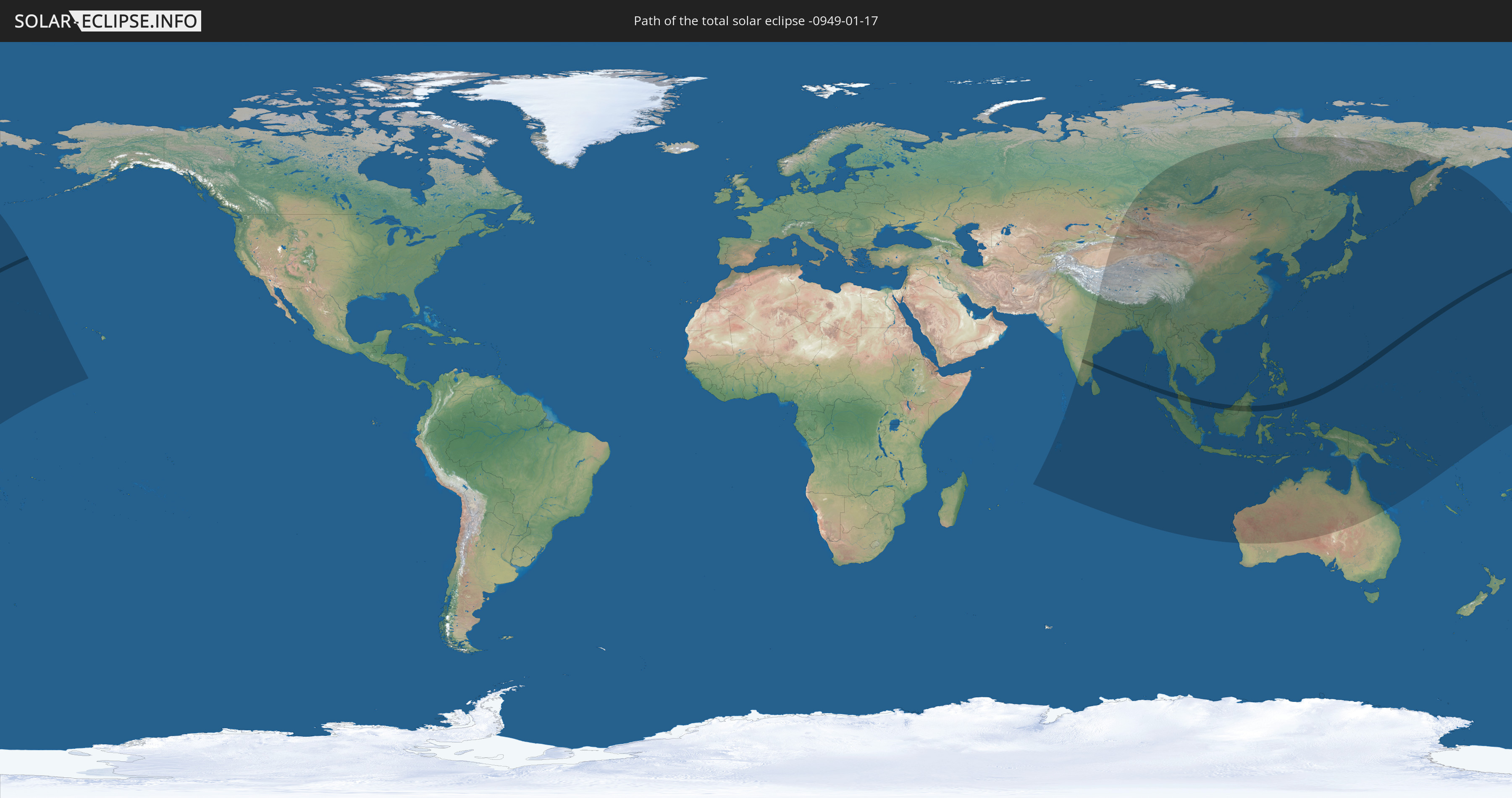
Die Sonnenfinsternis am 01/17/-0949 kann man in 41 Ländern als partielle Sonnenfinsternis beobachten.
Der Finsternispfad verläuft durch 7 Länder. Nur in diesen Ländern ist sie als total Sonnenfinsternis zu sehen.
In den folgenden Ländern ist die Sonnenfinsternis total zu sehen
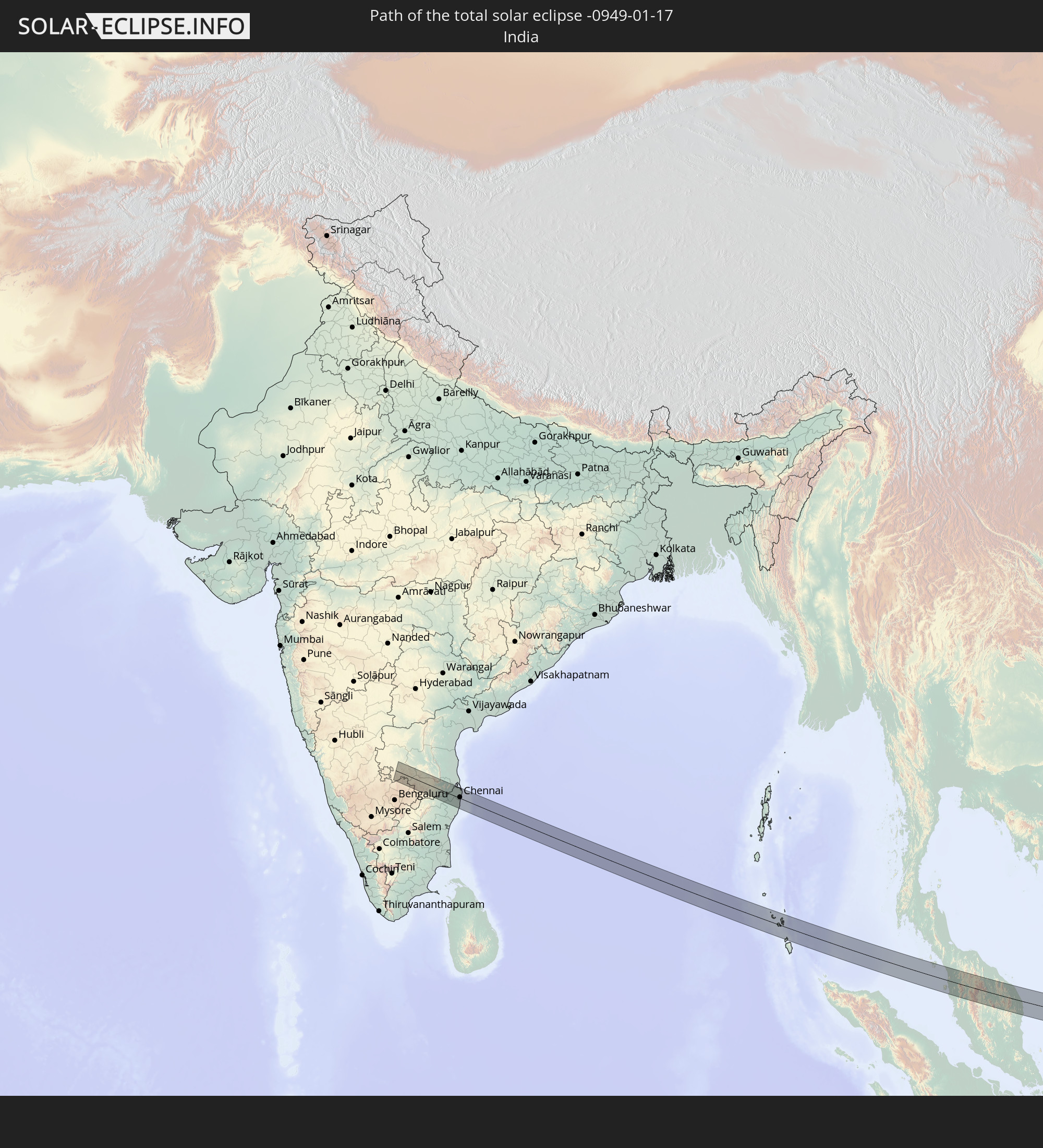 India
India
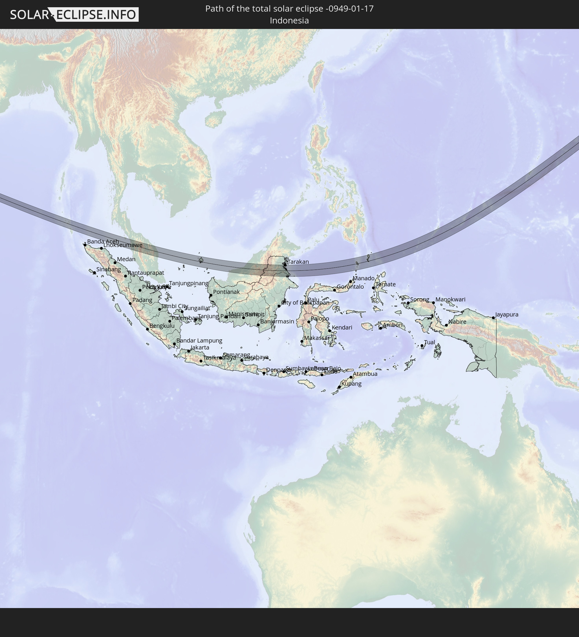 Indonesia
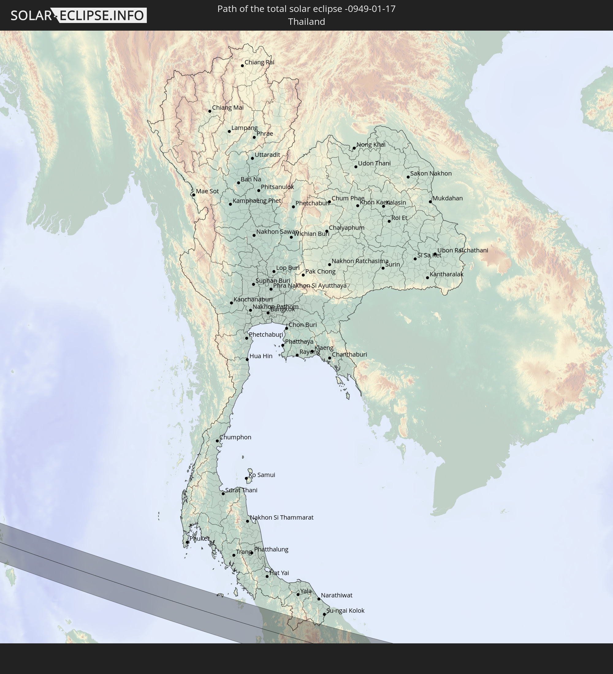 Thailand
 Malaysia
 Palau
Palau
 Federated States of Micronesia
 Guam
Guam
In den folgenden Ländern ist die Sonnenfinsternis partiell zu sehen
 Russia
 United States
 United States Minor Outlying Islands
 Kiribati
 India
India
 British Indian Ocean Territory
 Maldives
 China
China
 Sri Lanka
 Nepal
Nepal
 Mongolia
 Bangladesh
 Bhutan
 Myanmar
 Indonesia
 Cocos Islands
 Thailand
 Malaysia
 Laos
Laos
 Vietnam
 Cambodia
 Singapore
 Christmas Island
 Australia
 Macau
Macau
 Hong Kong
 Brunei
 Taiwan
 Philippines
 Japan
Japan
 East Timor
 North Korea
 South Korea
 Palau
Palau
 Federated States of Micronesia
 Papua New Guinea
 Guam
Guam
 Northern Mariana Islands
 Solomon Islands
 Marshall Islands
 Nauru
Nauru
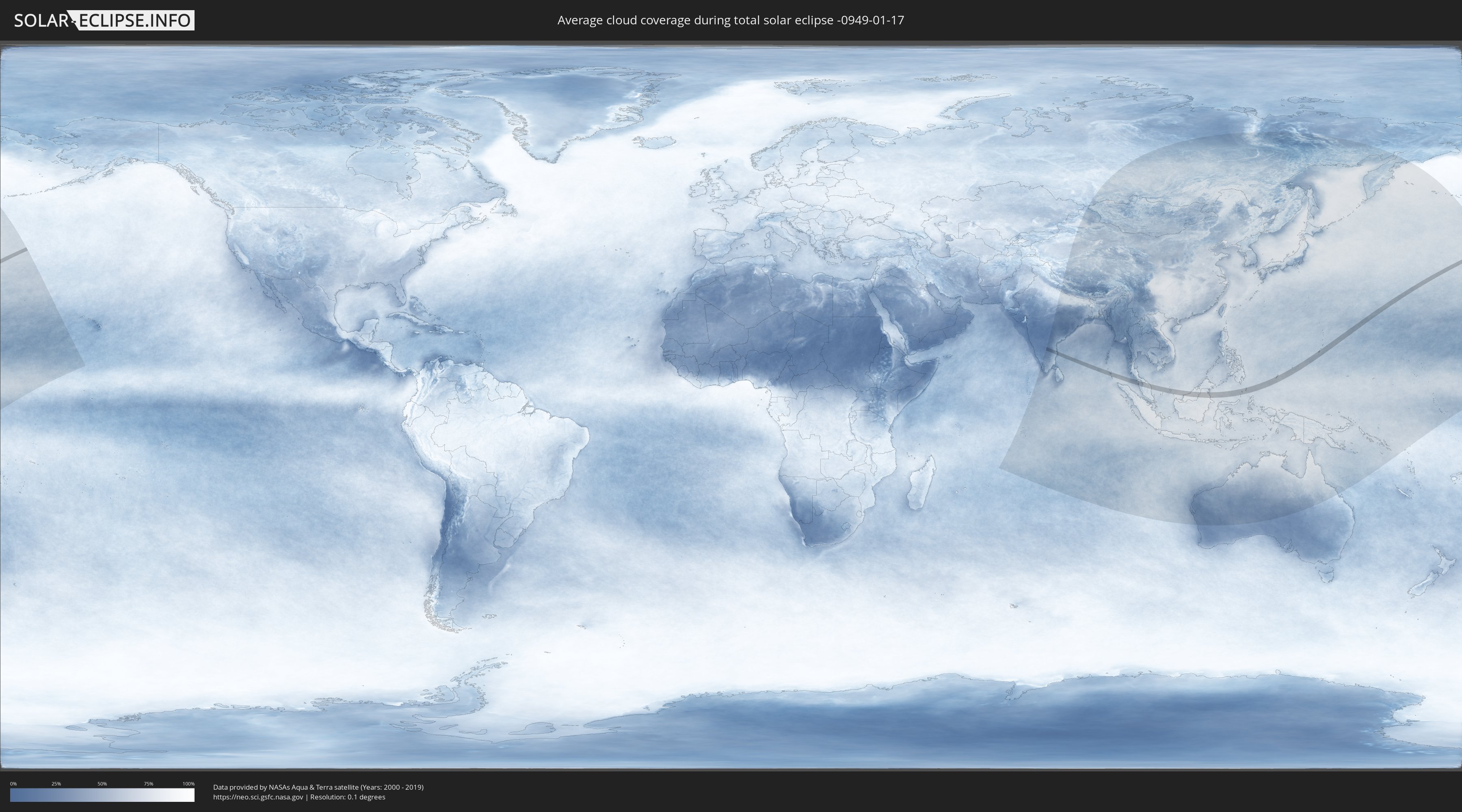
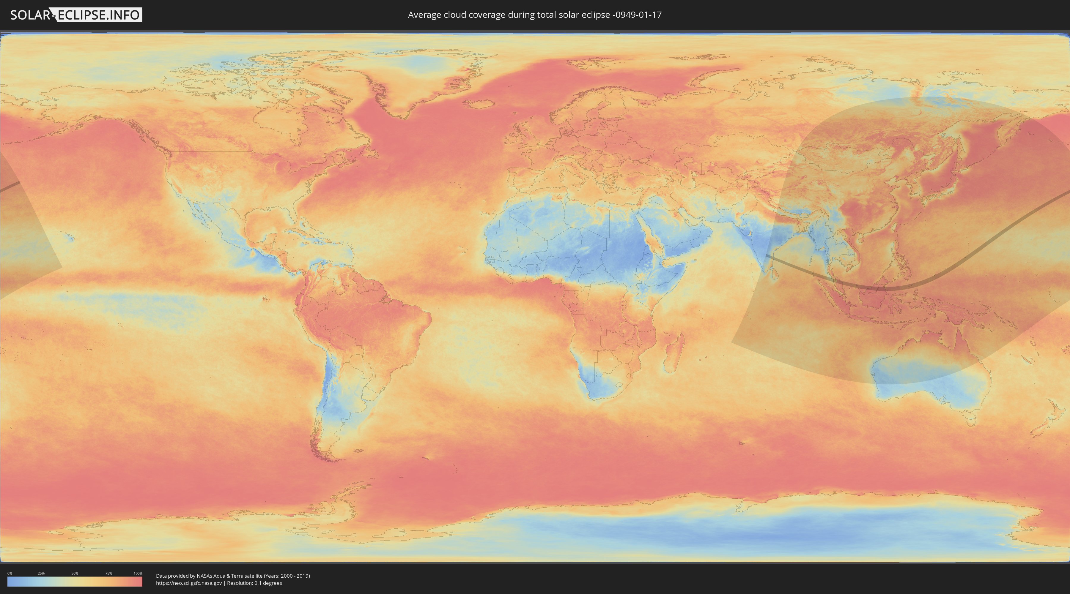
How will be the weather during the total solar eclipse on 01/17/-0949?
Where is the best place to see the total solar eclipse of 01/17/-0949?
The following maps show the average cloud coverage for the day of the total solar eclipse.
With the help of these maps, it is possible to find the place along the eclipse path, which has the best
chance of a cloudless sky.
Nevertheless, you should consider local circumstances and inform about the weather of your chosen
observation site.
The data is provided by NASAs satellites
AQUA and TERRA.
The cloud maps are averaged over a period of 19 years (2000 - 2019).
Detailed country maps
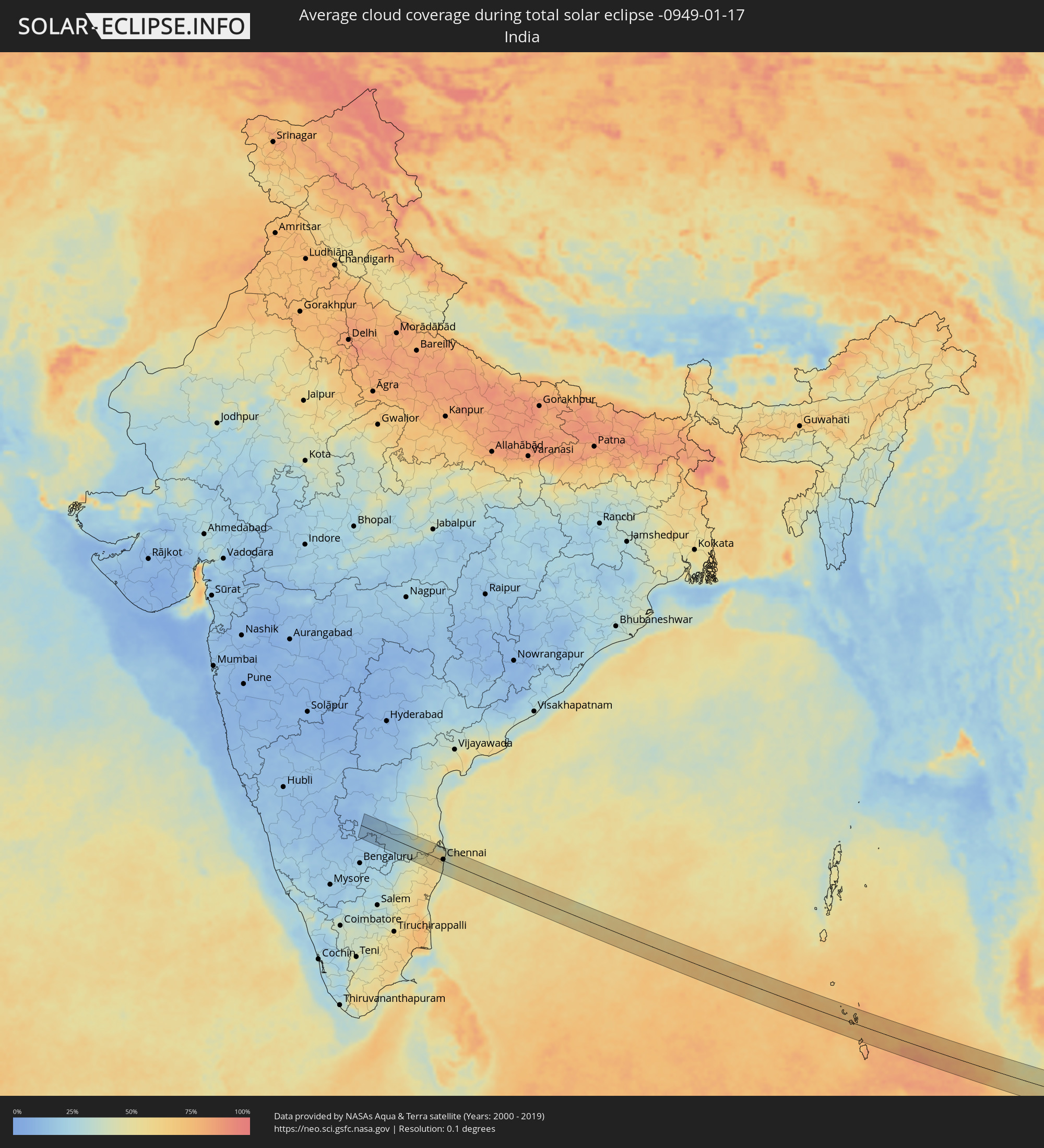 India
India
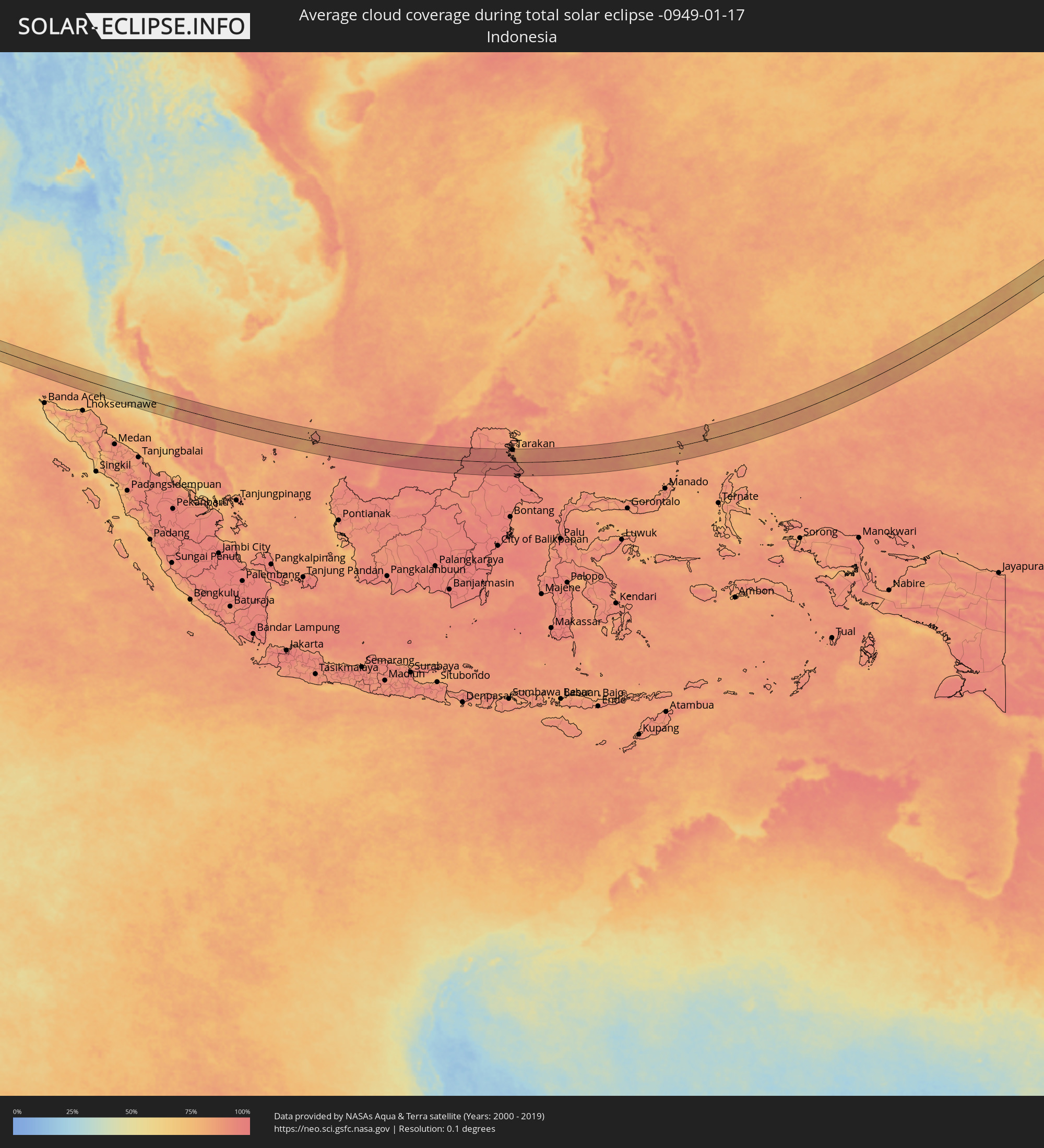 Indonesia
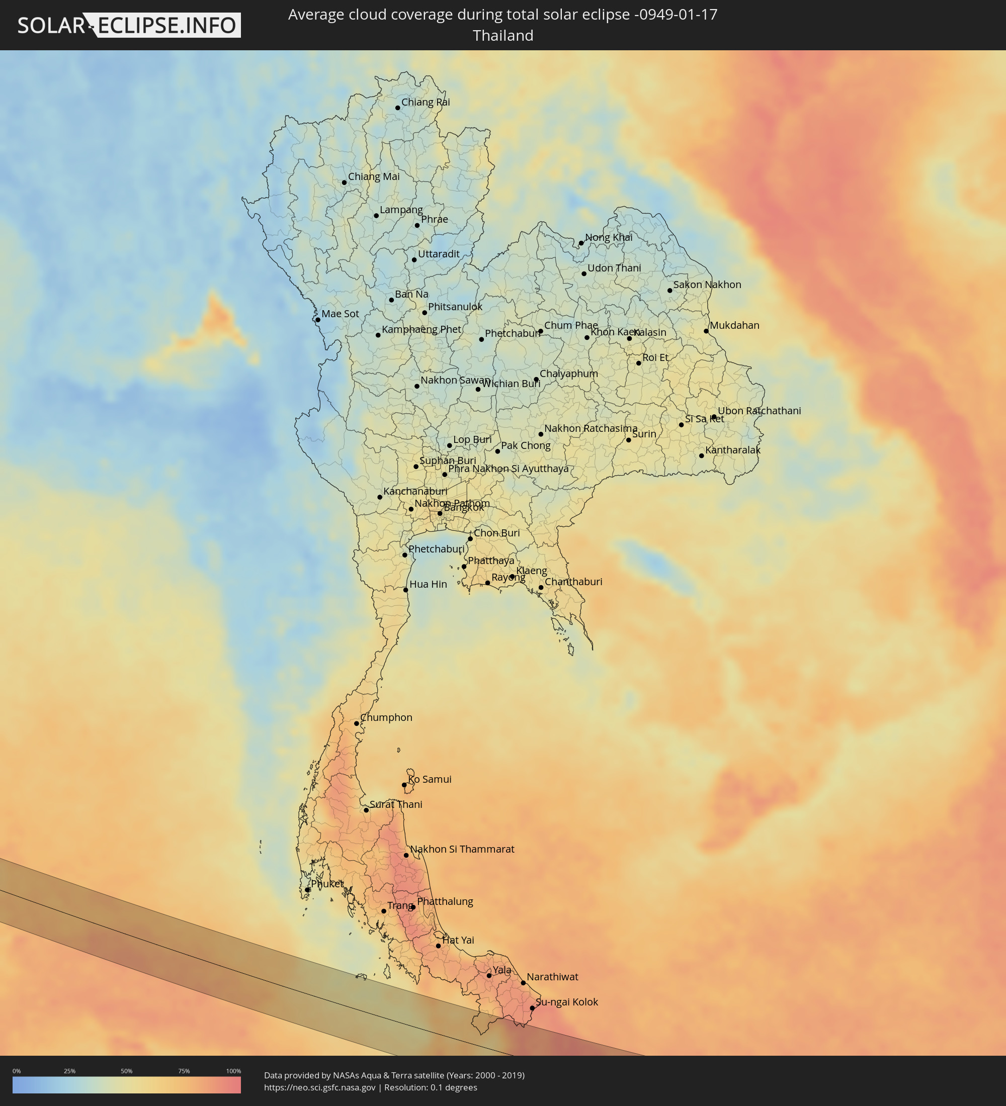 Thailand
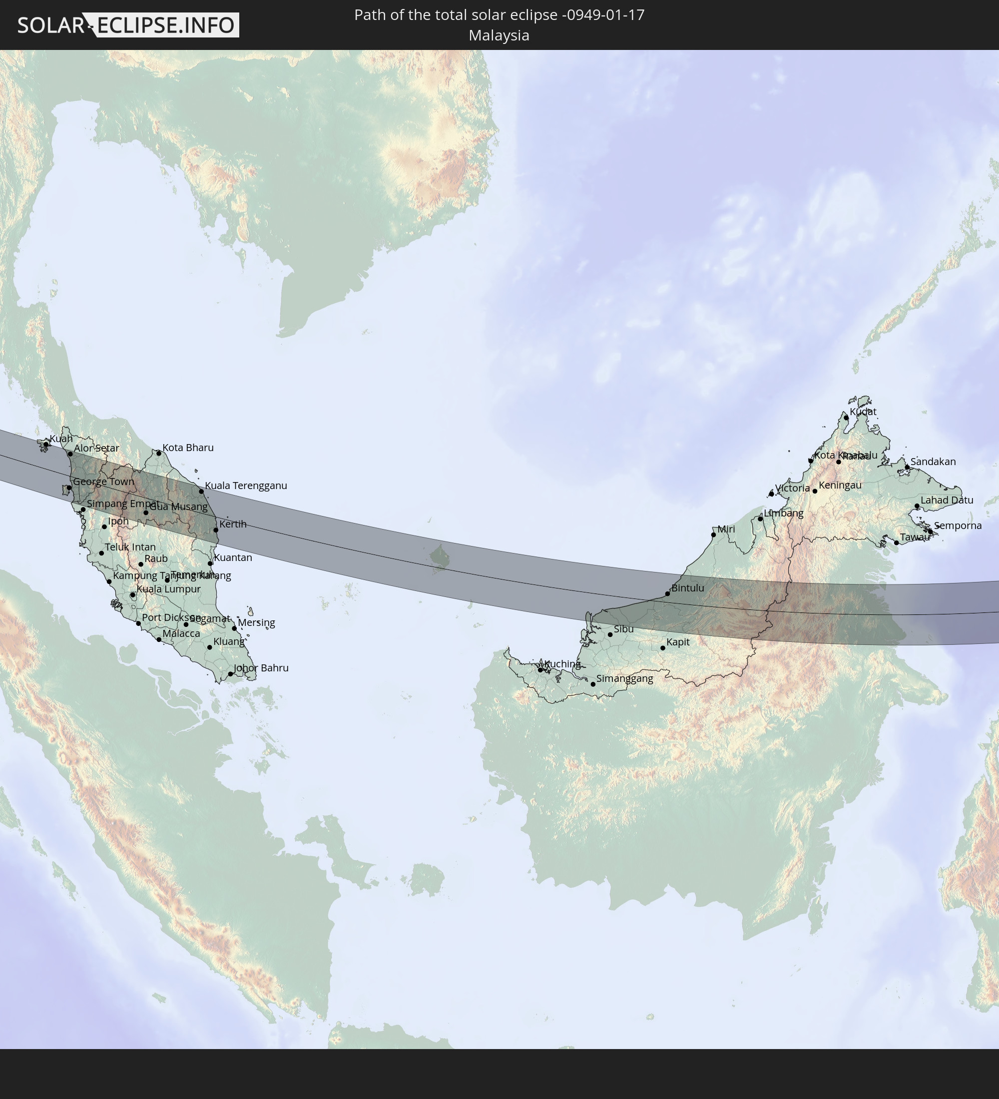
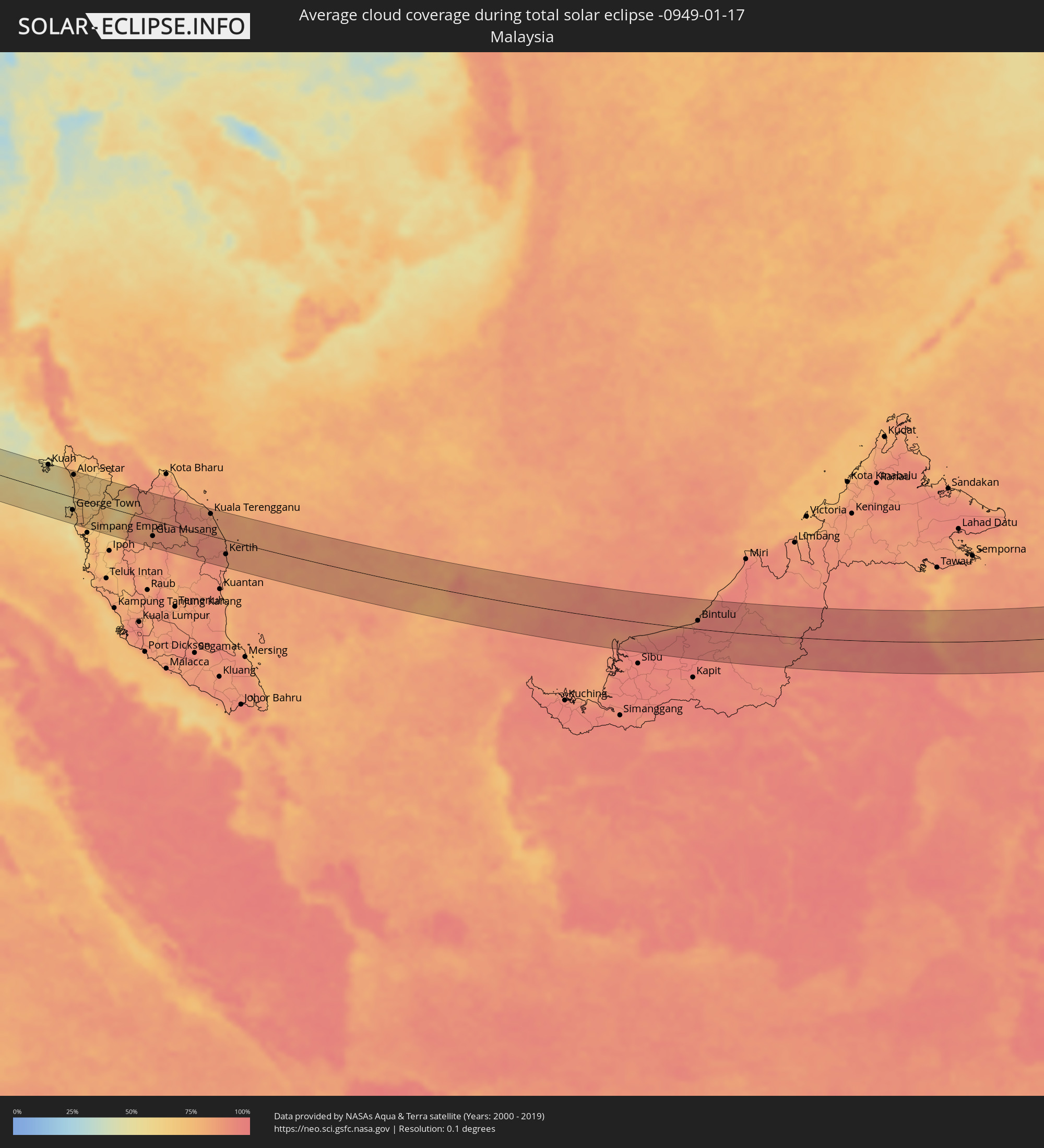 Malaysia
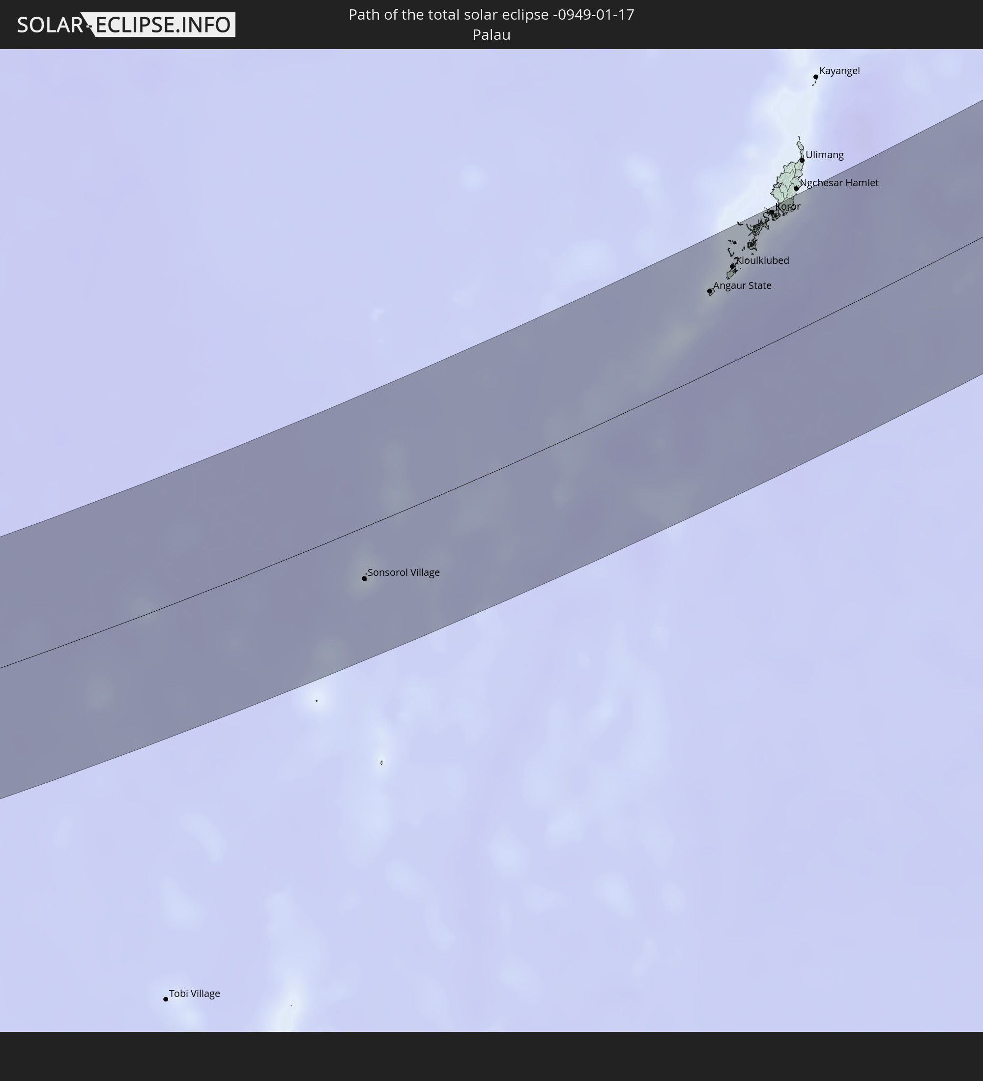
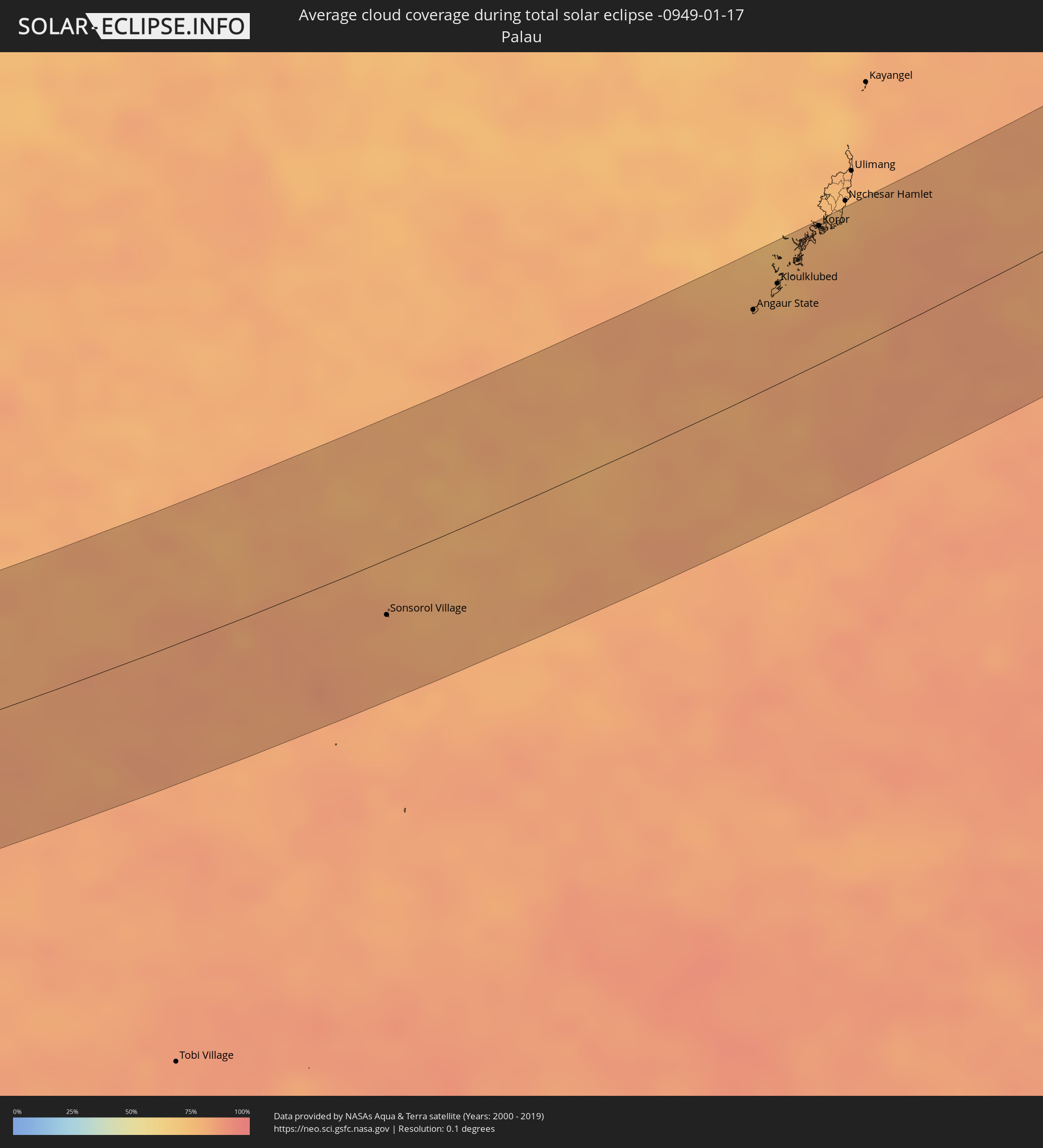 Palau
Palau
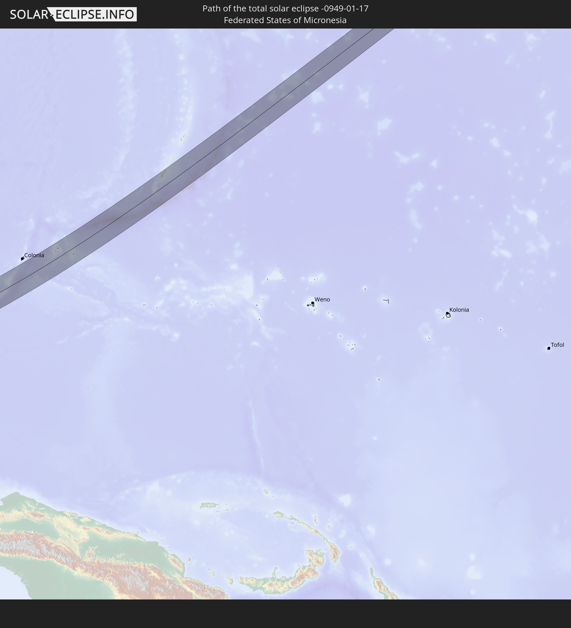
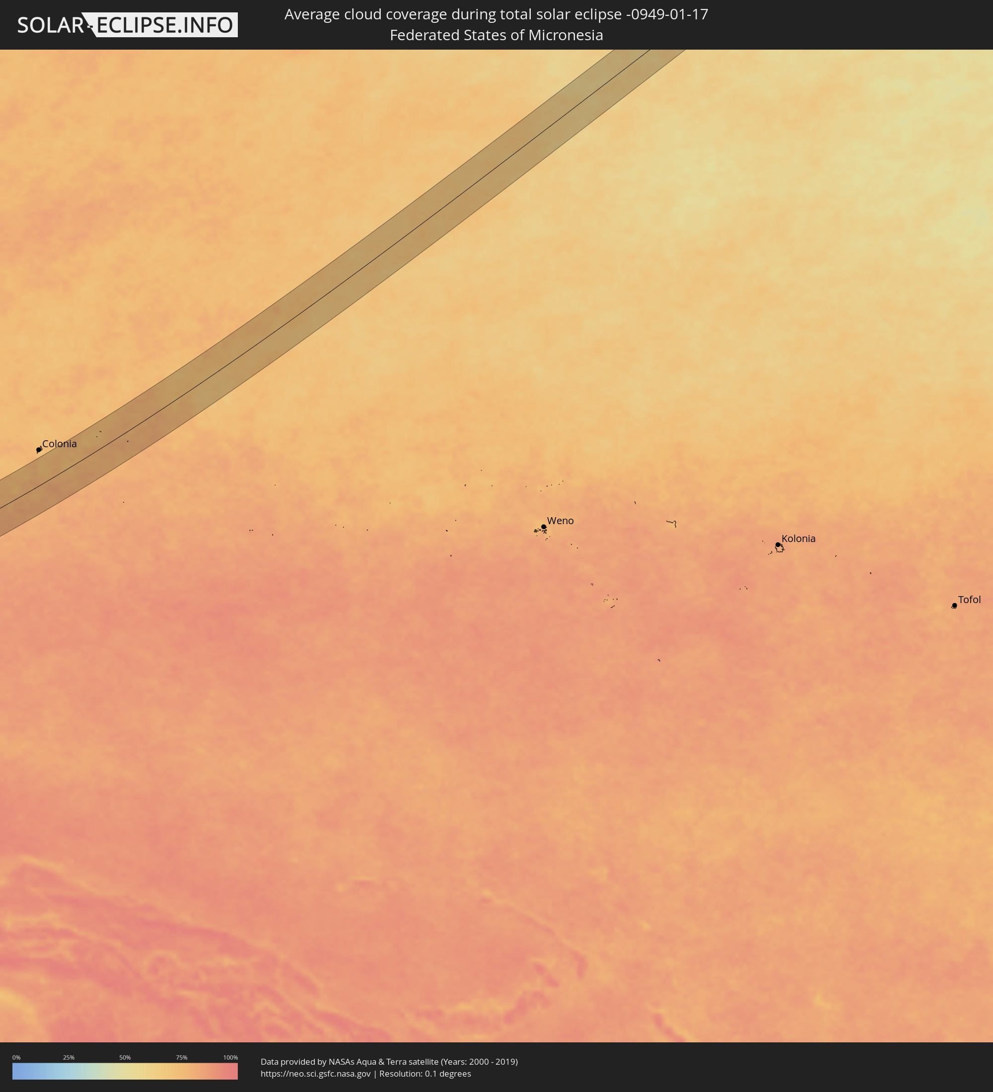 Federated States of Micronesia
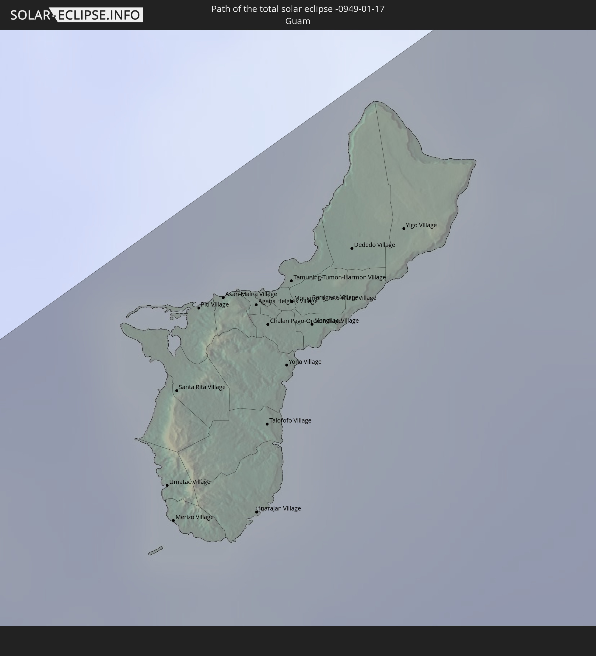
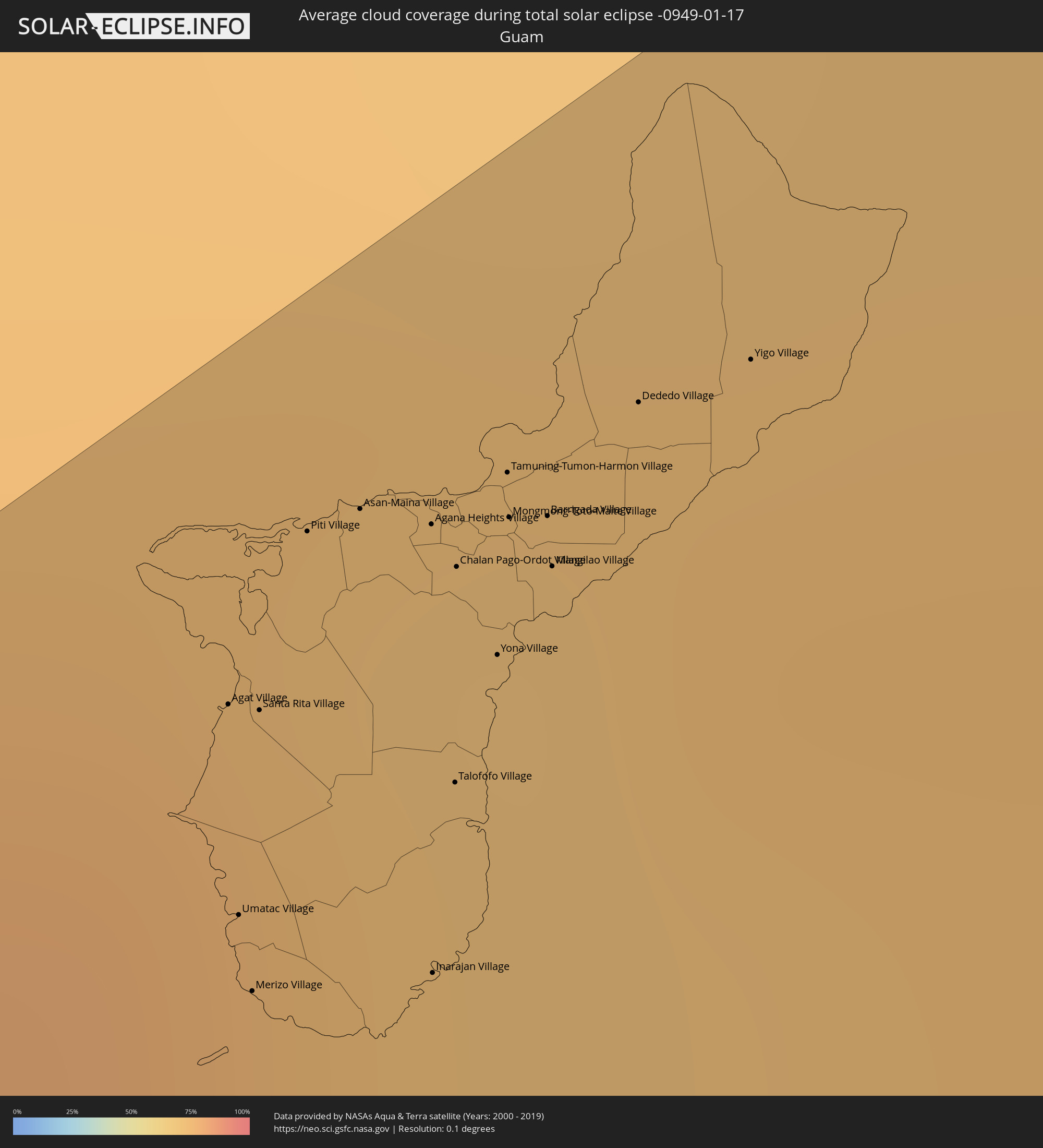 Guam
Guam
Cities inside the path of the eclipse
The following table shows all locations with a population of more than 5,000 inside the eclipse path. Cities which have more than 100,000 inhabitants are marked bold. A click at the locations opens a detailed map.
| City | Type | Eclipse duration | Local time of max. eclipse | Distance to central line | Ø Cloud coverage |
|
Dharmavaram, Andhra Pradesh
|
total | - | 06:48:45 UTC+05:21 | 30 km | 13% |
|
Bāgepalli, Karnataka
|
total | - | 06:48:24 UTC+05:21 | 31 km | 15% |
|
Kadiri, Andhra Pradesh
|
total | - | 06:48:41 UTC+05:21 | 18 km | 17% |
|
Madanapalle, Andhra Pradesh
|
total | - | 06:48:27 UTC+05:21 | 25 km | 21% |
|
Punganūru, Andhra Pradesh
|
total | - | 06:48:22 UTC+05:21 | 41 km | 21% |
|
Rāyachoti, Andhra Pradesh
|
total | - | 06:48:49 UTC+05:21 | 38 km | 22% |
|
Pākāla, Andhra Pradesh
|
total | - | 06:48:34 UTC+05:21 | 9 km | 32% |
|
Rāmāpuram, Andhra Pradesh
|
total | - | 06:48:24 UTC+05:21 | 42 km | 38% |
|
Tirumala, Andhra Pradesh
|
total | - | 06:48:47 UTC+05:21 | 25 km | 38% |
|
Tirupati, Andhra Pradesh
|
total | - | 06:48:46 UTC+05:21 | 23 km | 35% |
|
Akkarampalle, Andhra Pradesh
|
total | - | 06:48:47 UTC+05:21 | 25 km | 38% |
|
Sholinghur, Tamil Nadu
|
total | - | 06:48:28 UTC+05:21 | 30 km | 46% |
|
Renigunta, Andhra Pradesh
|
total | - | 06:48:48 UTC+05:21 | 27 km | 38% |
|
Puttūr, Andhra Pradesh
|
total | - | 06:48:42 UTC+05:21 | 9 km | 45% |
|
Nagari, Andhra Pradesh
|
total | - | 06:48:39 UTC+05:21 | 2 km | 46% |
|
Arakkonam, Tamil Nadu
|
total | - | 06:48:32 UTC+05:21 | 23 km | 52% |
|
Tiruvallur, Tamil Nadu
|
total | - | 06:48:39 UTC+05:21 | 7 km | 58% |
|
Srīperumbūdūr, Tamil Nadu
|
total | - | 06:48:34 UTC+05:21 | 23 km | 57% |
|
Tinnanūr, Tamil Nadu
|
total | - | 06:48:40 UTC+05:21 | 4 km | 58% |
|
Madambakkam, Tamil Nadu
|
total | - | 06:48:32 UTC+05:21 | 30 km | 59% |
|
Gūduvāncheri, Tamil Nadu
|
total | - | 06:48:32 UTC+05:21 | 31 km | 56% |
|
Gummidipundi, Tamil Nadu
|
total | - | 06:48:52 UTC+05:21 | 29 km | 59% |
|
Āvadi, Tamil Nadu
|
total | - | 06:48:42 UTC+05:21 | 1 km | 59% |
|
Pallāvaram, Tamil Nadu
|
total | - | 06:48:38 UTC+05:21 | 14 km | 50% |
|
Nāravārikuppam, Tamil Nadu
|
total | - | 06:48:46 UTC+05:21 | 10 km | 54% |
|
Ponneri, Tamil Nadu
|
total | - | 06:48:51 UTC+05:21 | 26 km | 57% |
|
Madipakkam, Tamil Nadu
|
total | - | 06:48:39 UTC+05:21 | 13 km | 50% |
|
Chetput, Tamil Nadu
|
total | - | 06:48:43 UTC+05:21 | 0 km | 53% |
|
Perungudi, Tamil Nadu
|
total | - | 06:48:39 UTC+05:21 | 11 km | 50% |
|
Injambakkam, Tamil Nadu
|
total | - | 06:48:38 UTC+05:21 | 15 km | 46% |
|
Palavakkam, Tamil Nadu
|
total | - | 06:48:39 UTC+05:21 | 11 km | 41% |
|
Mīnjūr, Tamil Nadu
|
total | - | 06:48:51 UTC+05:21 | 22 km | 47% |
|
Neelankarai, Tamil Nadu
|
total | - | 06:48:39 UTC+05:21 | 12 km | 42% |
|
Chennai, Tamil Nadu
|
total | - | 06:48:45 UTC+05:21 | 3 km | 39% |
|
Pantai Cenang, Perlis
|
total | - | 08:35:09 UTC+06:55 | 47 km | 58% |
|
Padang Mat Sirat, Kedah
|
total | - | 08:35:12 UTC+06:55 | 54 km | 54% |
|
Kuah, Kedah
|
total | - | 08:35:20 UTC+06:55 | 54 km | 53% |
|
Telaga Batu, Penang
|
total | - | 08:35:27 UTC+06:55 | 25 km | 58% |
|
Kampung Sungai Ara, Penang
|
total | - | 08:35:27 UTC+06:55 | 39 km | 60% |
|
Kuala Kedah, Kedah
|
total | - | 08:35:51 UTC+06:55 | 45 km | 66% |
|
Tanjung Tokong, Penang
|
total | - | 08:35:33 UTC+06:55 | 23 km | 63% |
|
George Town, Penang
|
total | - | 08:35:34 UTC+06:55 | 28 km | 69% |
|
Alor Setar, Kedah
|
total | - | 08:35:56 UTC+06:55 | 49 km | 70% |
|
Butterworth, Penang
|
total | - | 08:35:36 UTC+06:55 | 28 km | 73% |
|
Permatang Kuching, Penang
|
total | - | 08:35:40 UTC+06:55 | 21 km | 72% |
|
Perai, Penang
|
total | - | 08:35:38 UTC+06:55 | 29 km | 73% |
|
Kepala Batas, Penang
|
total | - | 08:35:45 UTC+06:55 | 13 km | 72% |
|
Juru, Penang
|
total | - | 08:35:41 UTC+06:55 | 35 km | 65% |
|
Bukit Mertajam, Penang
|
total | - | 08:35:44 UTC+06:55 | 29 km | 78% |
|
Gurun, Kedah
|
total | - | 08:35:57 UTC+06:55 | 20 km | 70% |
|
Nibong Tebal, Penang
|
total | - | 08:35:40 UTC+06:55 | 49 km | 79% |
|
Sungai Petani, Kedah
|
total | - | 08:35:54 UTC+06:55 | 2 km | 73% |
|
Parit Buntar, Perak
|
total | - | 08:35:40 UTC+06:55 | 53 km | 78% |
|
Tasek Glugor, Penang
|
total | - | 08:35:50 UTC+06:55 | 15 km | 73% |
|
Bedong, Kedah
|
total | - | 08:35:58 UTC+06:55 | 12 km | 73% |
|
Kulim, Kedah
|
total | - | 08:35:52 UTC+06:55 | 25 km | 73% |
|
Betong, Yala
|
total | - | 08:23:26 UTC+06:42 | 34 km | 73% |
|
Gua Musang, Kelantan
|
total | - | 08:37:40 UTC+06:55 | 34 km | 87% |
|
Kuala Terengganu, Terengganu
|
total | - | 08:39:41 UTC+06:55 | 48 km | 88% |
|
Marang, Terengganu
|
total | - | 08:39:43 UTC+06:55 | 36 km | 87% |
|
Paka, Terengganu
|
total | - | 08:39:49 UTC+06:55 | 18 km | 90% |
|
Kertih, Terengganu
|
total | - | 08:39:47 UTC+06:55 | 31 km | 91% |
|
Bintulu, Sarawak
|
total | - | 09:23:34 UTC+07:21 | 19 km | 91% |
|
Tanjung Selor, North Kalimantan
|
total | - | 10:10:13 UTC+07:57 | 11 km | 93% |
|
Tarakan, North Kalimantan
|
total | - | 10:11:08 UTC+07:57 | 64 km | 88% |
|
Sonsorol Village, Sonsorol
|
total | - | 11:58:11 UTC+09:00 | 30 km | 80% |
|
Angaur State, Angaur
|
total | - | 12:05:38 UTC+09:00 | 44 km | 80% |
|
Kloulklubed, Peleliu
|
total | - | 12:06:09 UTC+09:00 | 52 km | 77% |
|
Koror, Koror
|
total | - | 12:07:07 UTC+09:00 | 71 km | 79% |
|
Koror Town, Koror
|
total | - | 12:07:09 UTC+09:00 | 71 km | 79% |
|
Ngetkib, Airai
|
total | - | 12:07:16 UTC+09:00 | 72 km | 77% |
|
Agat Village, Agat
|
total | - | 13:40:30 UTC+10:00 | 55 km | 74% |
|
Umatac Village, Umatac
|
total | - | 13:40:26 UTC+10:00 | 46 km | 74% |
|
Merizo Village, Merizo
|
total | - | 13:40:25 UTC+10:00 | 43 km | 74% |
|
Santa Rita Village, Santa Rita
|
total | - | 13:40:32 UTC+10:00 | 54 km | 74% |
|
Piti Village, Piti
|
total | - | 13:40:39 UTC+10:00 | 59 km | 72% |
|
Asan-Maina Village, Asan
|
total | - | 13:40:43 UTC+10:00 | 59 km | 72% |
|
Agana Heights Village, Agana Heights
|
total | - | 13:40:47 UTC+10:00 | 56 km | 72% |
|
Inarajan Village, Inarajan
|
total | - | 13:40:36 UTC+10:00 | 39 km | 74% |
|
Hagåtña, Hagatna
|
total | - | 13:40:47 UTC+10:00 | 57 km | 72% |
|
Guam Government House, Hagatna
|
total | - | 13:40:47 UTC+10:00 | 56 km | 72% |
|
Sinajana Village, Sinajana
|
total | - | 13:40:47 UTC+10:00 | 55 km | 70% |
|
Talofofo Village, Talofofo
|
total | - | 13:40:42 UTC+10:00 | 45 km | 71% |
|
Chalan Pago-Ordot Village, Chalan Pago-Ordot
|
total | - | 13:40:47 UTC+10:00 | 54 km | 71% |
|
Yona Village, Yona
|
total | - | 13:40:48 UTC+10:00 | 49 km | 71% |
|
Tamuning-Tumon-Harmon Village, Tamuning
|
total | - | 13:40:52 UTC+10:00 | 56 km | 70% |
|
Mongmong-Toto-Maite Village, Mongmong-Toto-Maite
|
total | - | 13:40:52 UTC+10:00 | 54 km | 70% |
|
Barrigada Village, Barrigada
|
total | - | 13:40:54 UTC+10:00 | 53 km | 70% |
|
Mangilao Village, Mangilao
|
total | - | 13:40:53 UTC+10:00 | 51 km | 71% |
|
Dededo Village, Dededo
|
total | - | 13:41:02 UTC+10:00 | 55 km | 70% |
|
Yigo Village, Yigo
|
total | - | 13:41:10 UTC+10:00 | 53 km | 73% |