Total solar eclipse of 03/18/-1055
| Day of week: | Tuesday |
| Maximum duration of eclipse: | 06m17s |
| Maximum width of eclipse path: | 234 km |
| Saros cycle: | 32 |
| Coverage: | 100% |
| Magnitude: | 1.0706 |
| Gamma: | 0.189 |
Wo kann man die Sonnenfinsternis vom 03/18/-1055 sehen?
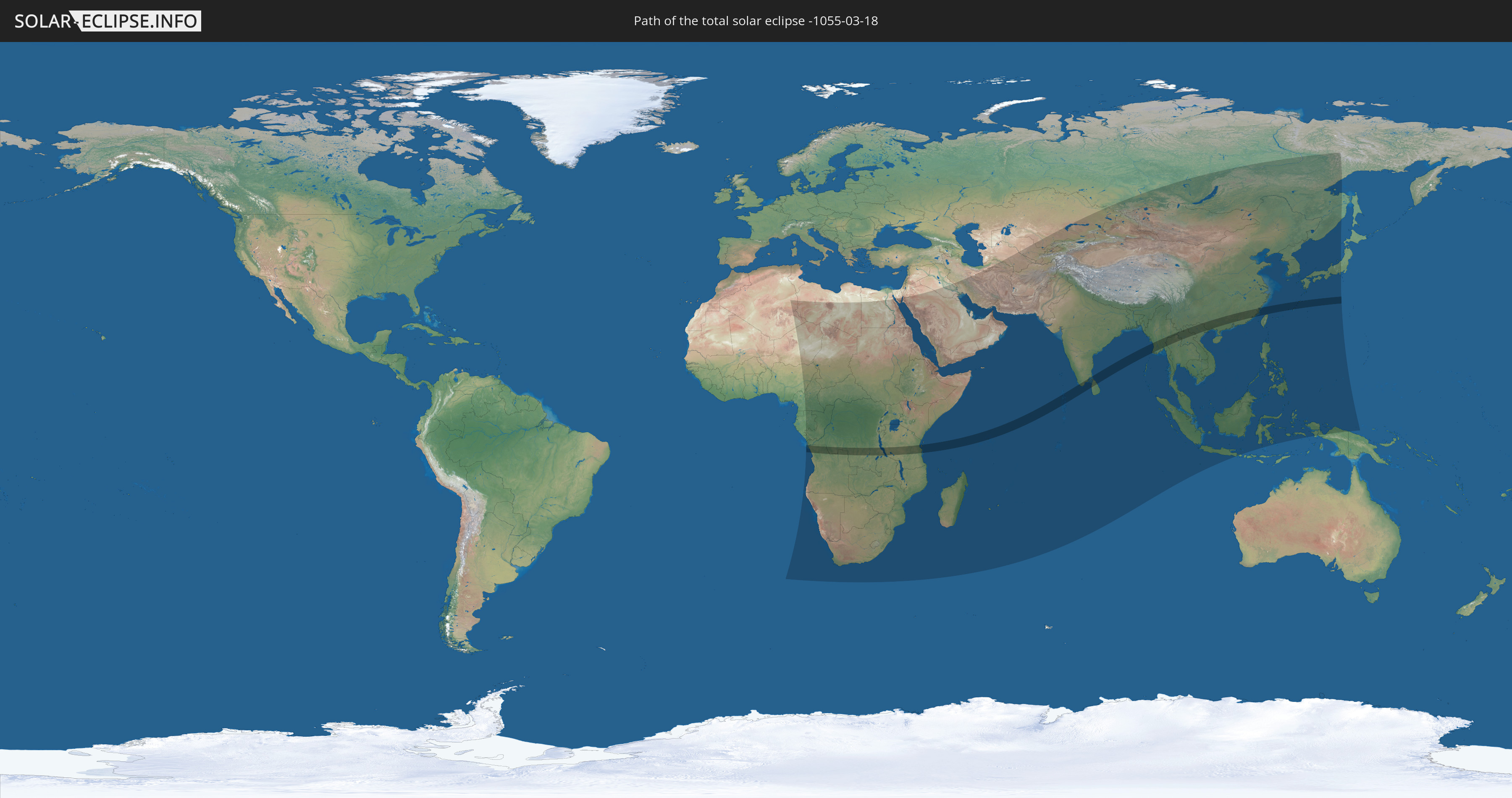
Die Sonnenfinsternis am 03/18/-1055 kann man in 86 Ländern als partielle Sonnenfinsternis beobachten.
Der Finsternispfad verläuft durch 15 Länder. Nur in diesen Ländern ist sie als total Sonnenfinsternis zu sehen.
In den folgenden Ländern ist die Sonnenfinsternis total zu sehen
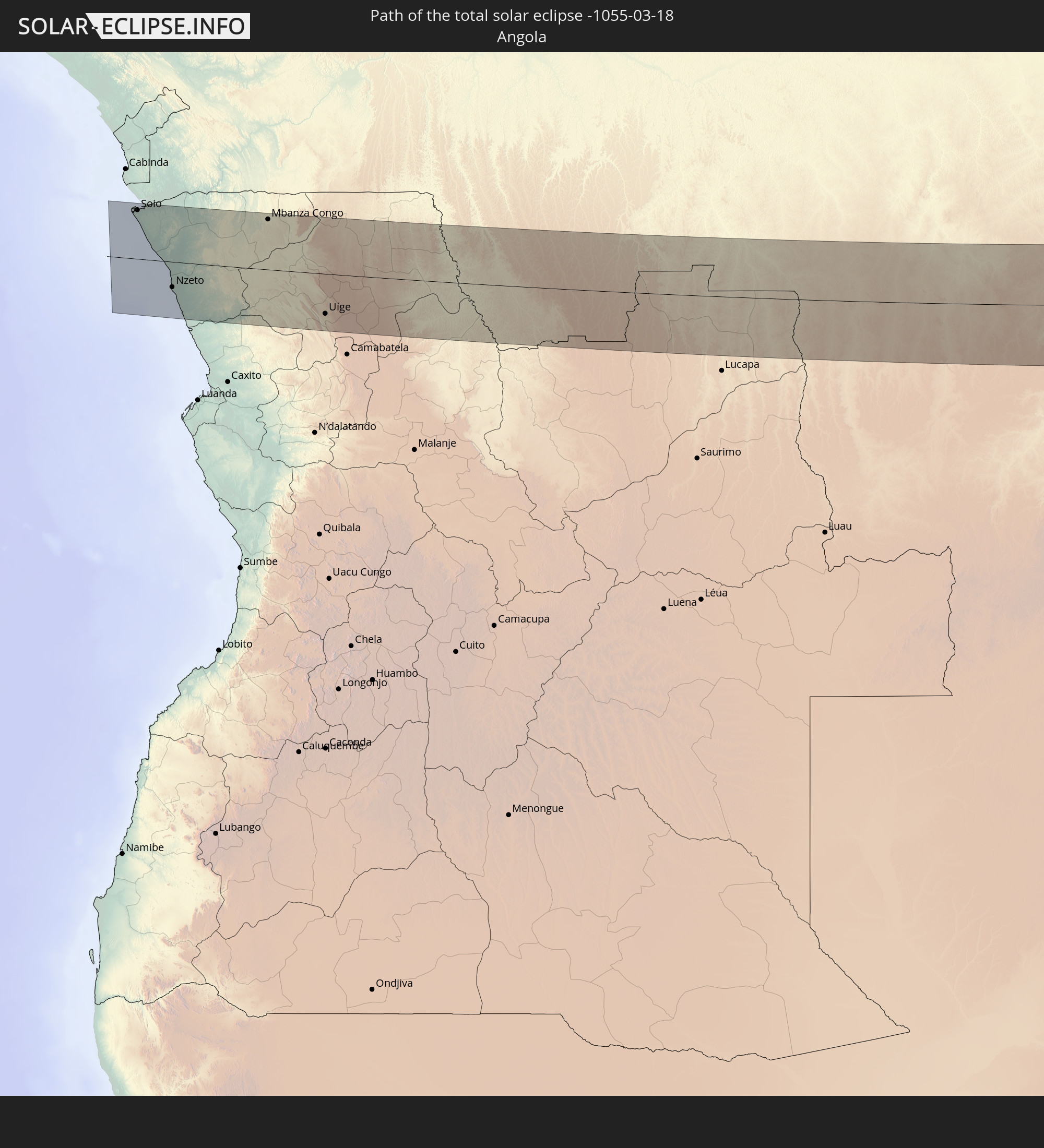 Angola
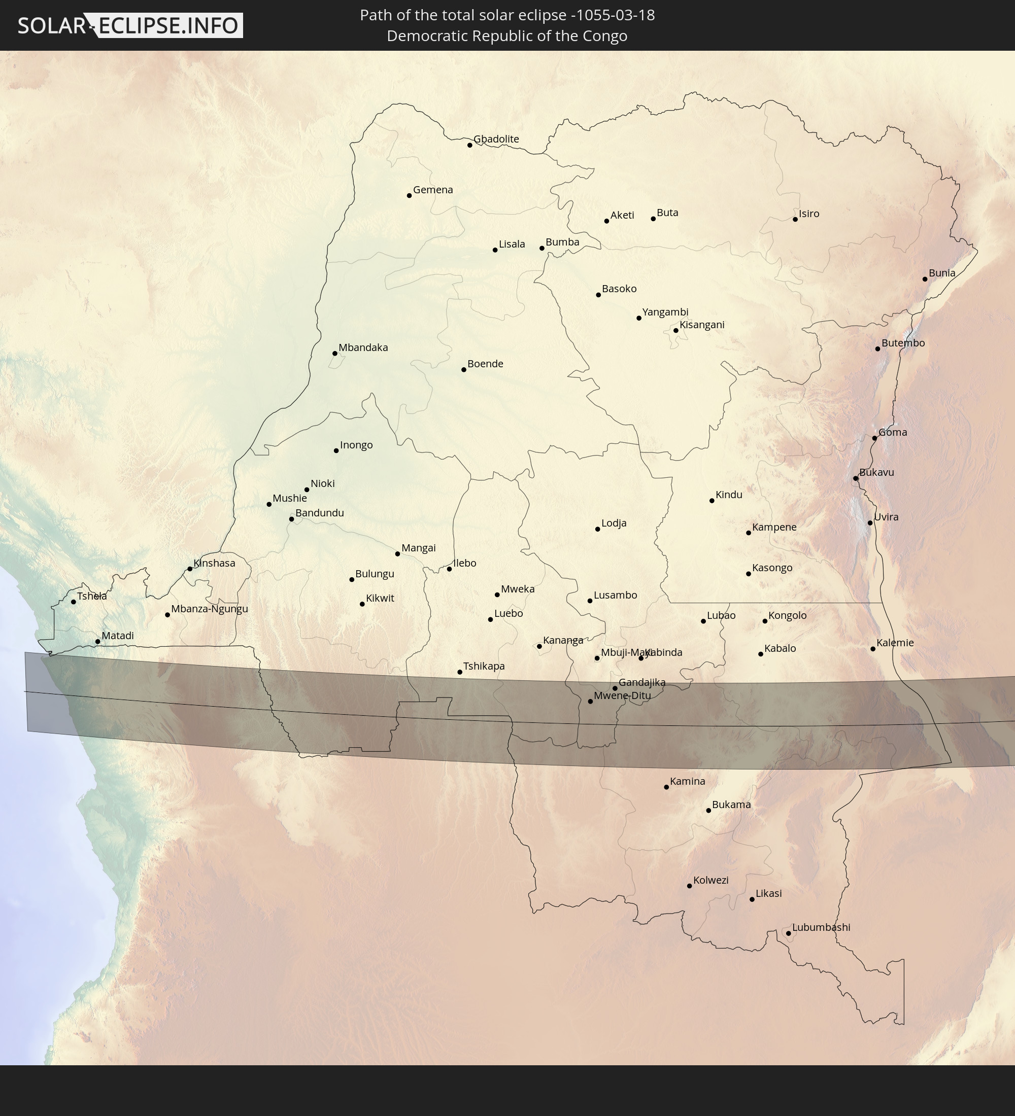 Democratic Republic of the Congo
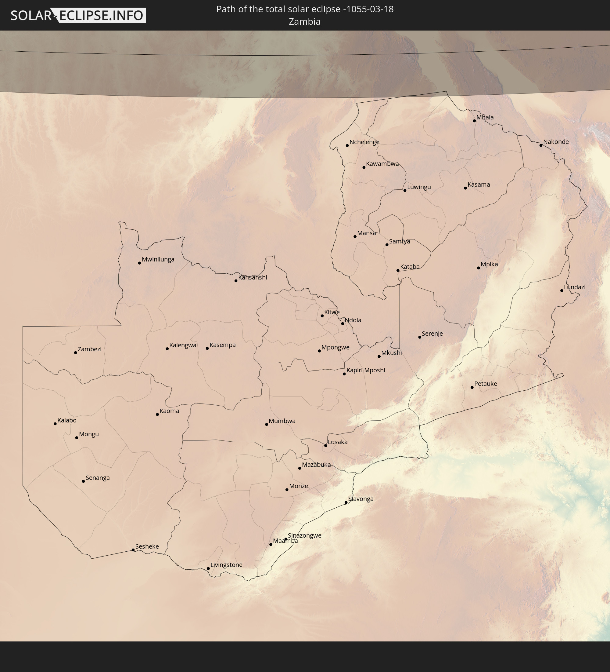 Zambia
 Tanzania
 Seychelles
 India
India
 Maldives
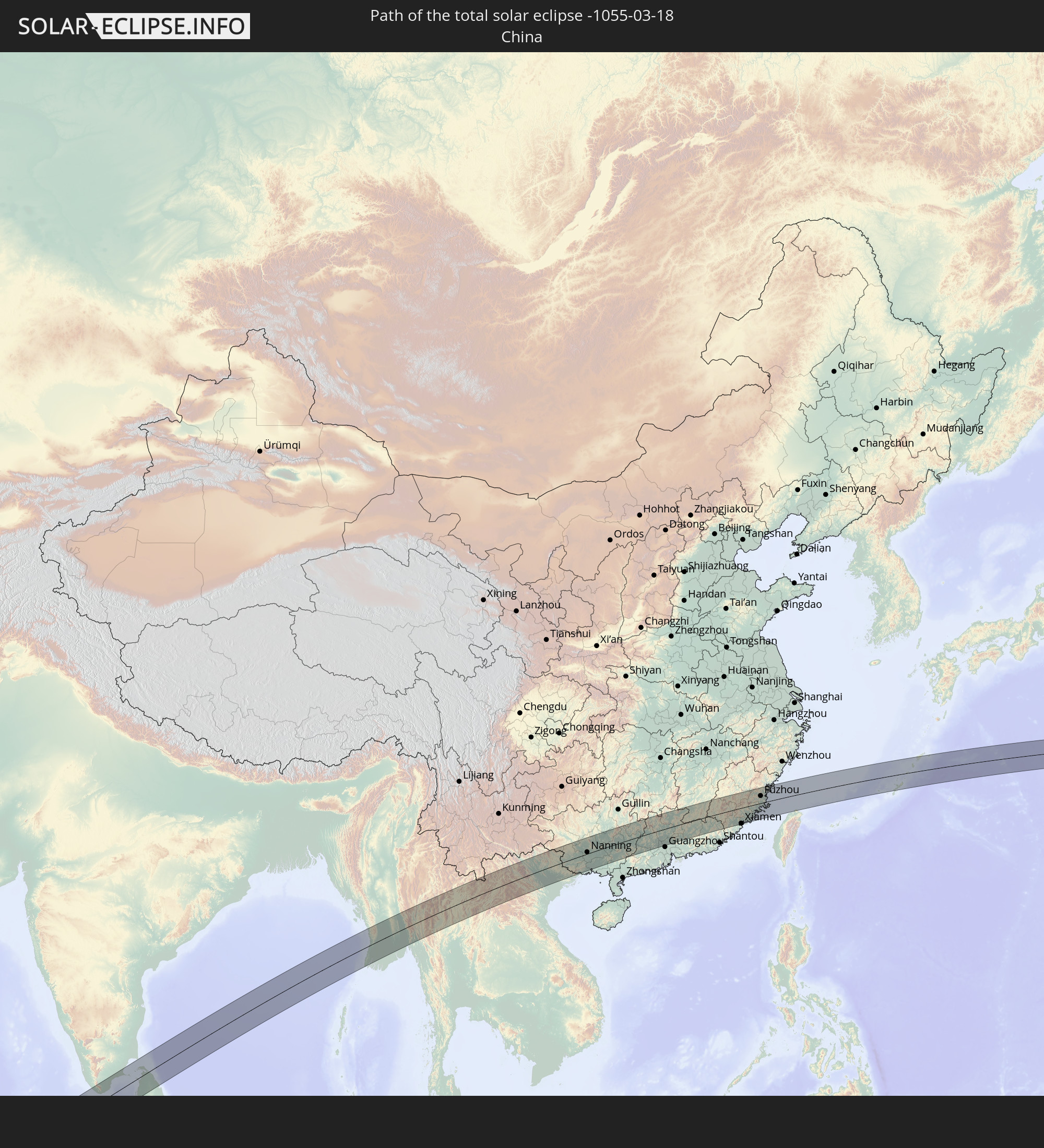 China
China
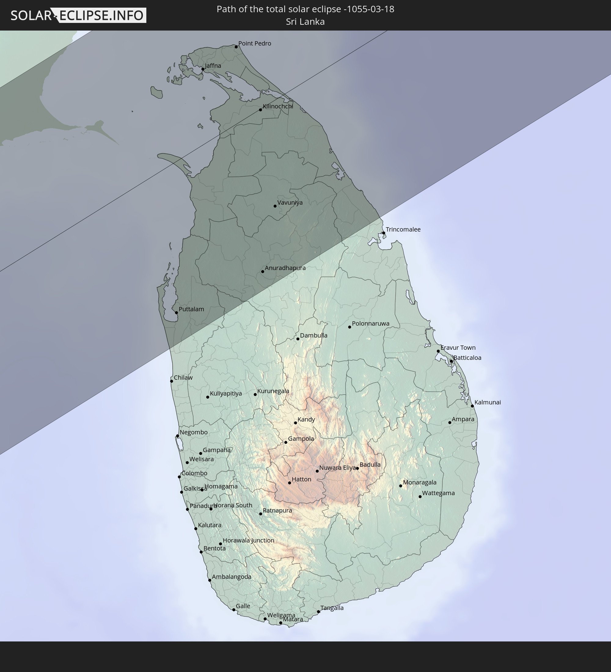 Sri Lanka
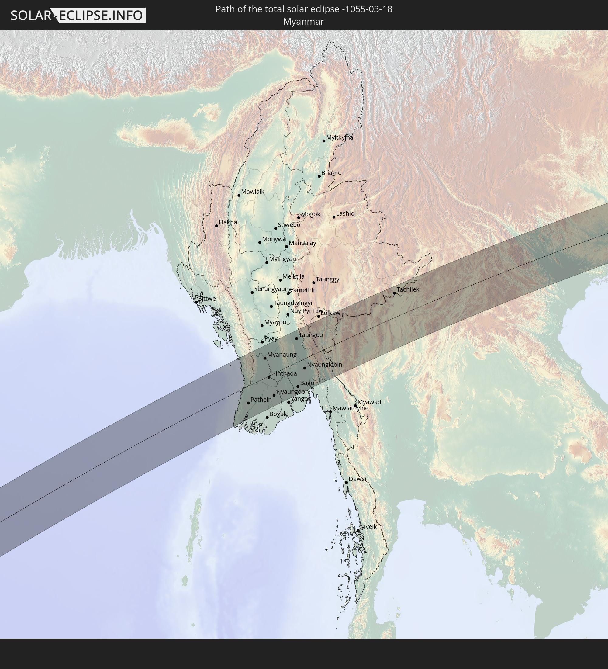 Myanmar
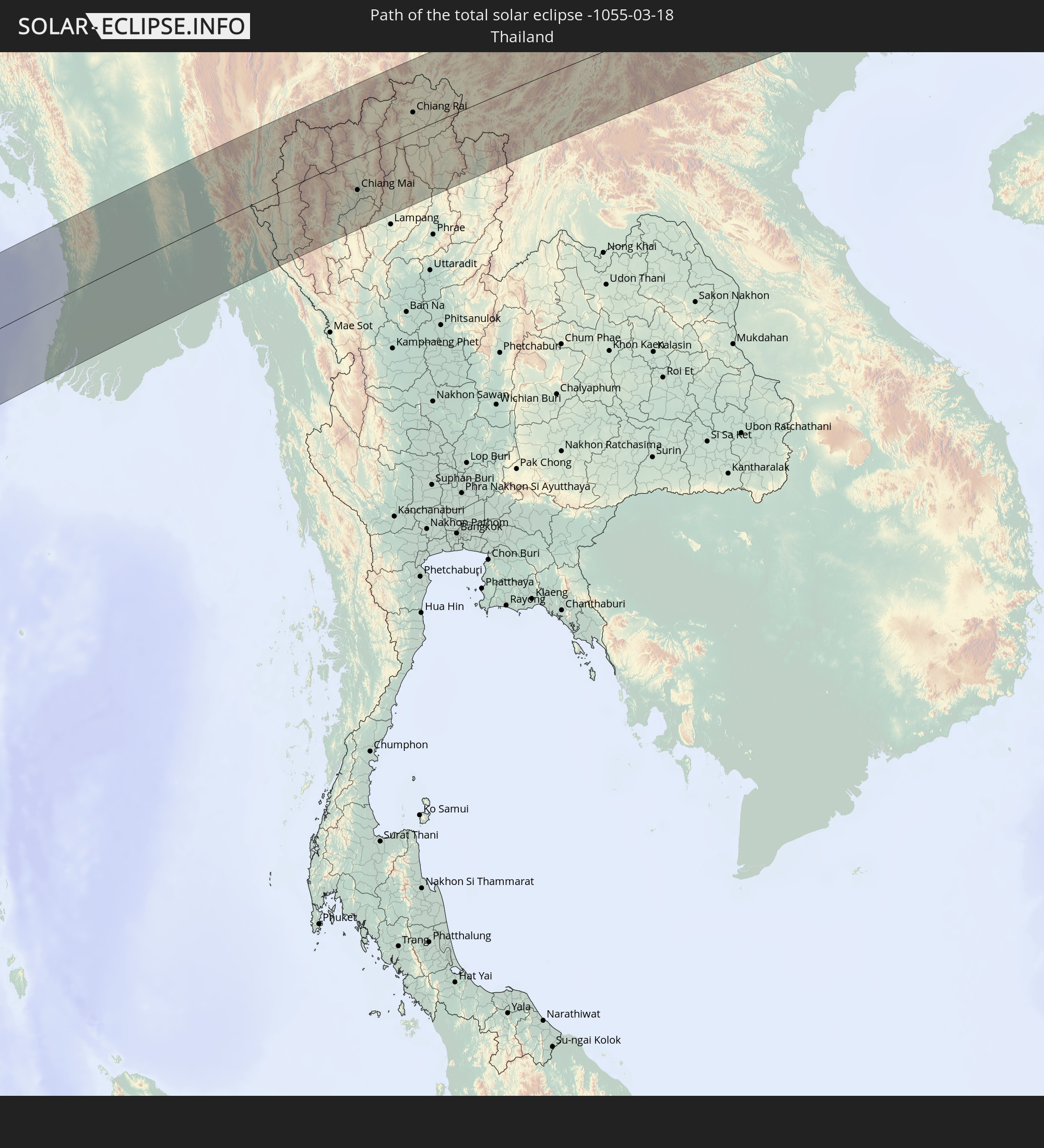 Thailand
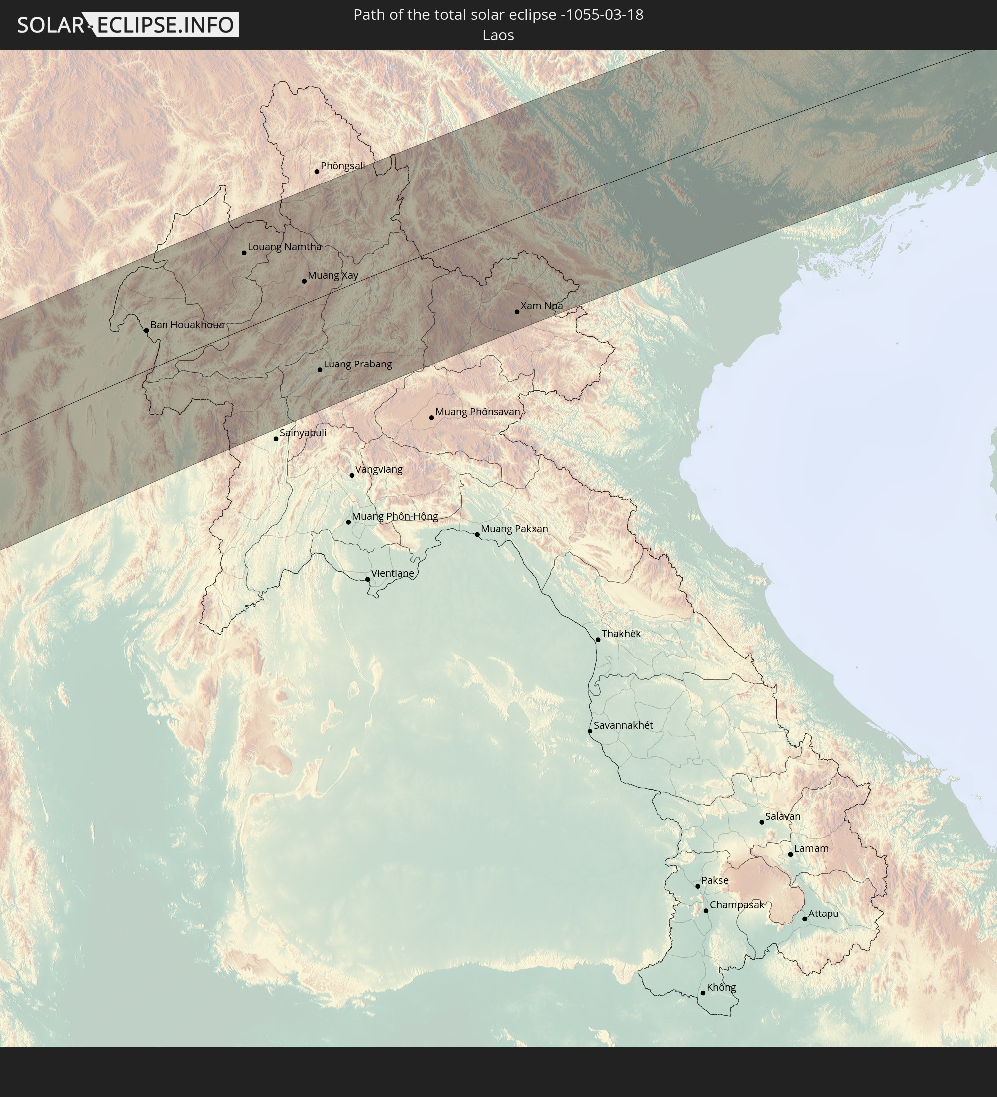 Laos
Laos
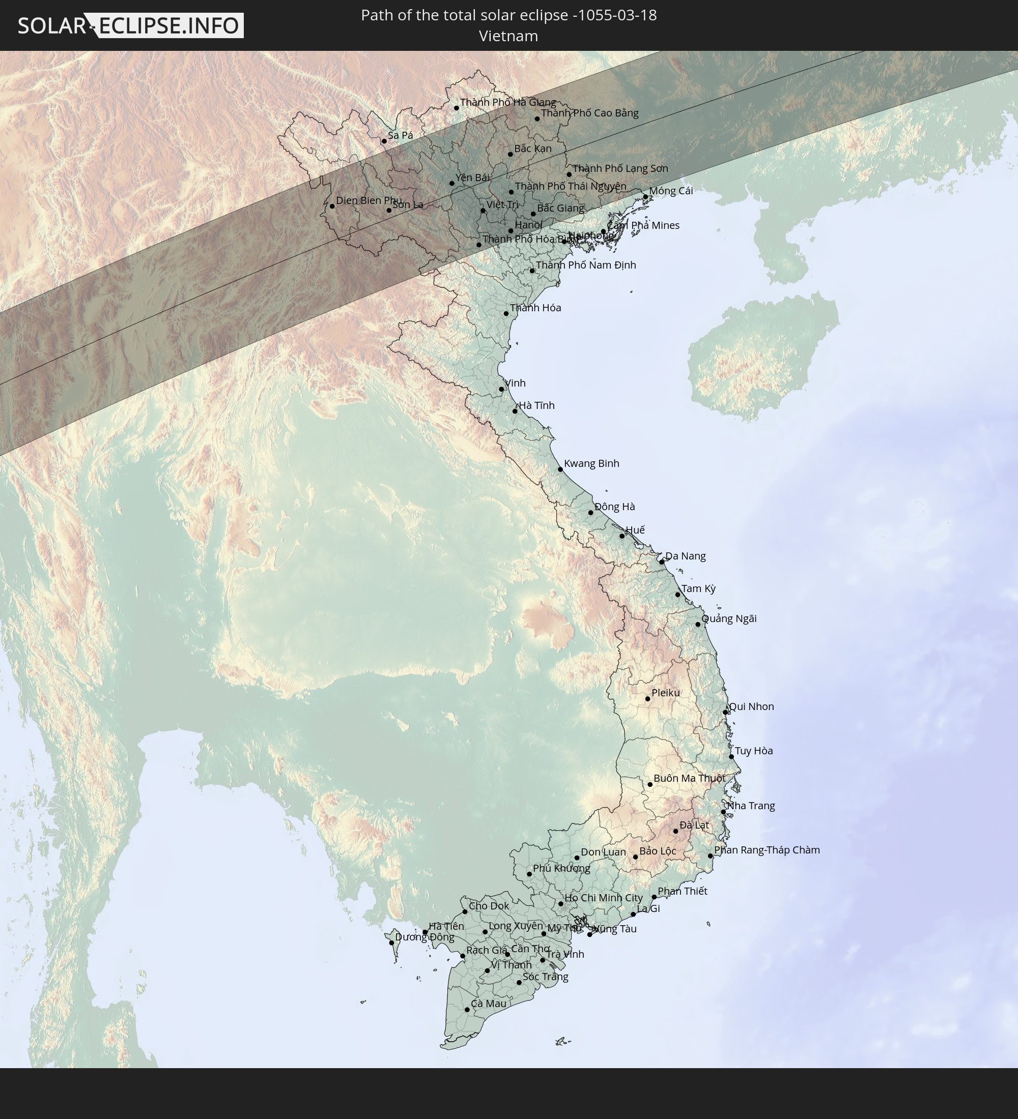 Vietnam
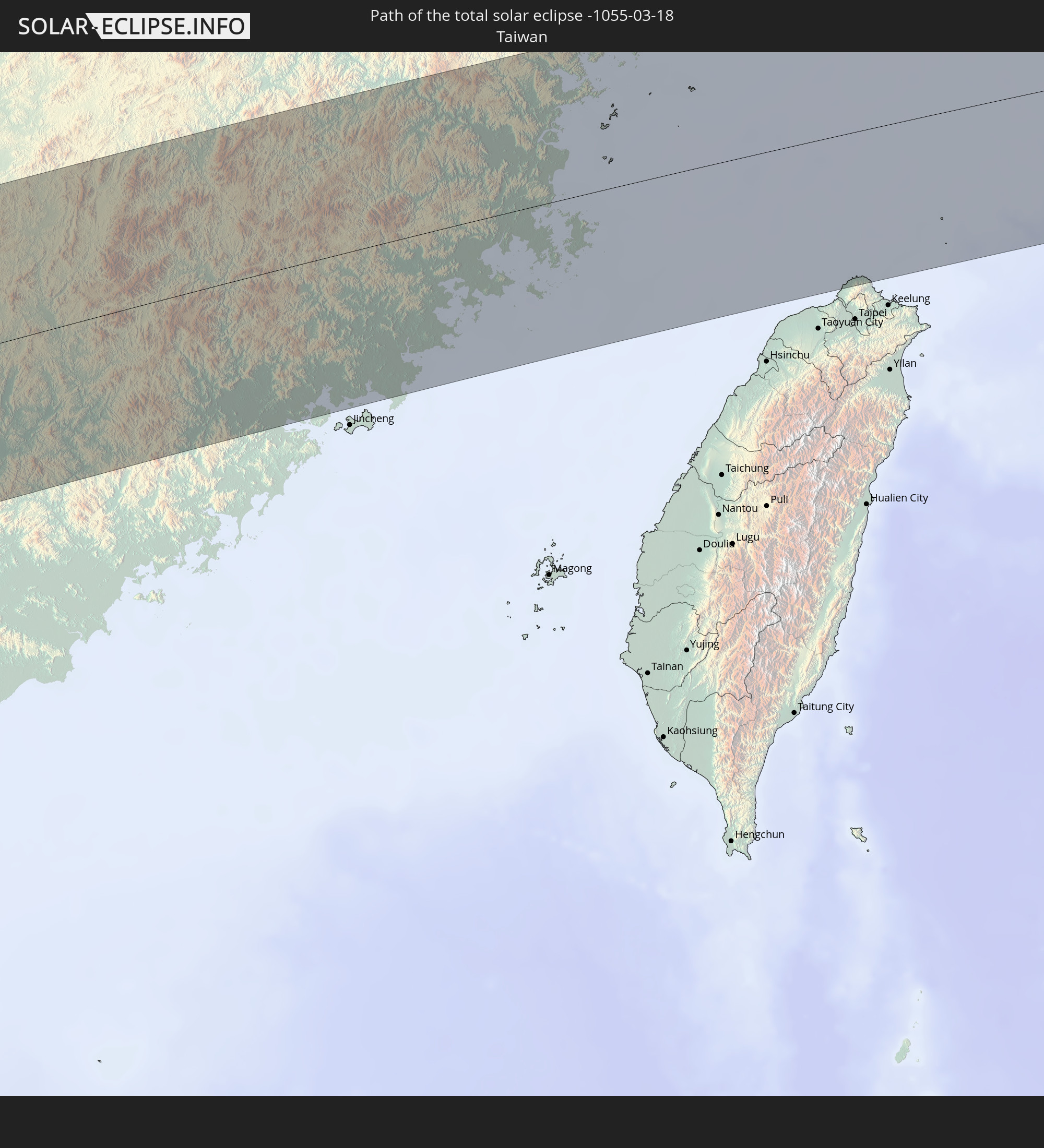 Taiwan
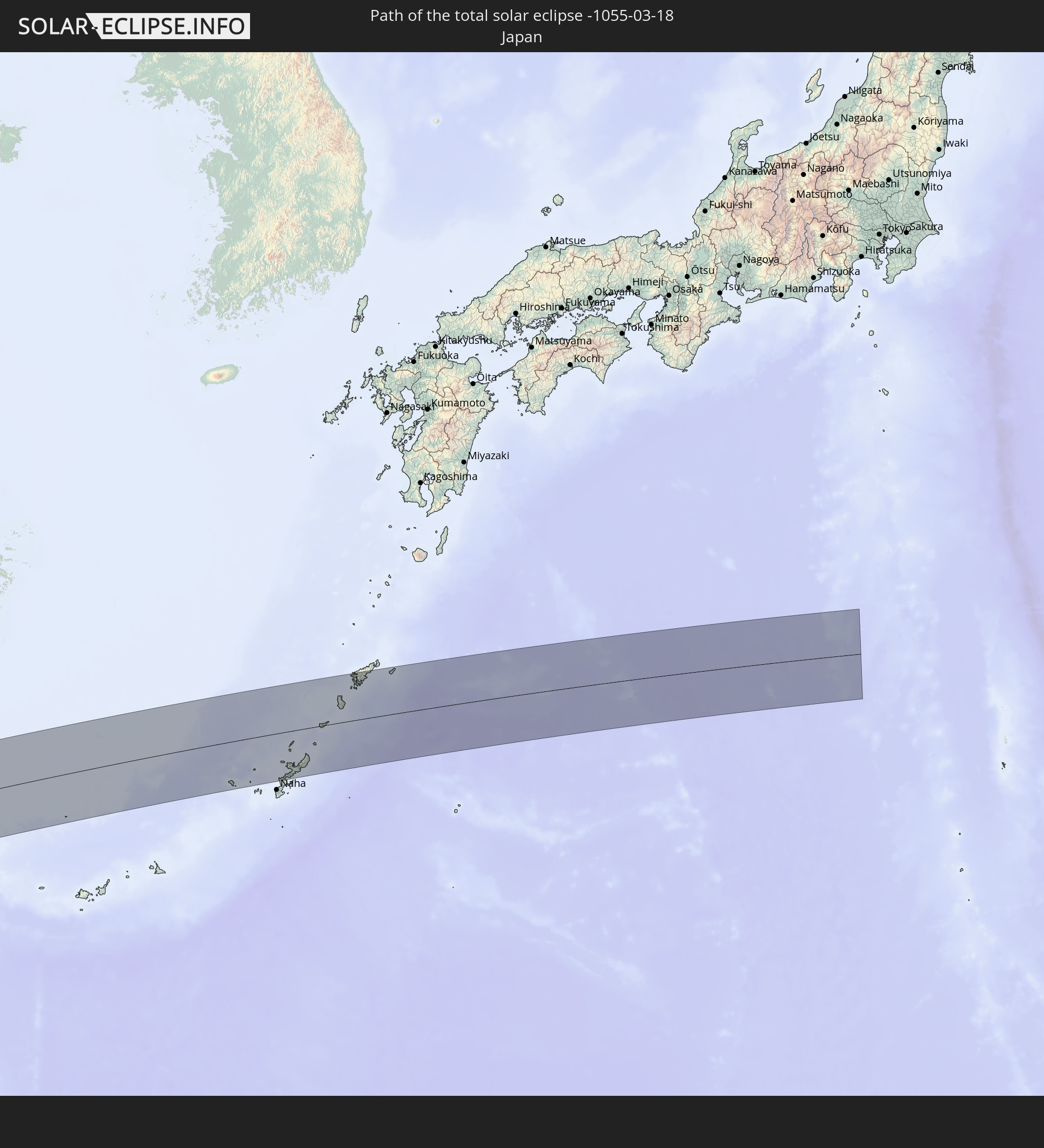 Japan
Japan
In den folgenden Ländern ist die Sonnenfinsternis partiell zu sehen
 Russia
 Algeria
 Niger
Niger
 Nigeria
 Cameroon
 Gabon
Gabon
 Libya
Libya
 Republic of the Congo
 Angola
 Namibia
 Democratic Republic of the Congo
 Chad
Chad
 Central African Republic
 South Africa
 Botswana
 Sudan
Sudan
 Zambia
 Egypt
Egypt
 Zimbabwe
 Lesotho
 Rwanda
 Burundi
 Tanzania
 Uganda
 Mozambique
 Swaziland
 Malawi
 Ethiopia
 Kenya
Kenya
 Saudi Arabia
 Jordan
 Eritrea
 Iraq
Iraq
 French Southern and Antarctic Lands
 Somalia
 Djibouti
 Yemen
Yemen
 Madagascar
 Comoros
 Iran
Iran
 Mayotte
 Seychelles
 Kazakhstan
 Kuwait
 Bahrain
 Qatar
Qatar
 United Arab Emirates
 Oman
Oman
 Turkmenistan
 Réunion
 Uzbekistan
 Mauritius
 Afghanistan
 Pakistan
 Tajikistan
 India
India
 Kyrgyzstan
 British Indian Ocean Territory
 Maldives
 China
China
 Sri Lanka
 Nepal
Nepal
 Mongolia
 Bangladesh
 Bhutan
 Myanmar
 Indonesia
 Cocos Islands
 Thailand
 Malaysia
 Laos
Laos
 Vietnam
 Cambodia
 Singapore
 Christmas Island
 Macau
Macau
 Hong Kong
 Brunei
 Taiwan
 Philippines
 Japan
Japan
 North Korea
 South Korea
 Palau
Palau
 Federated States of Micronesia
 Papua New Guinea
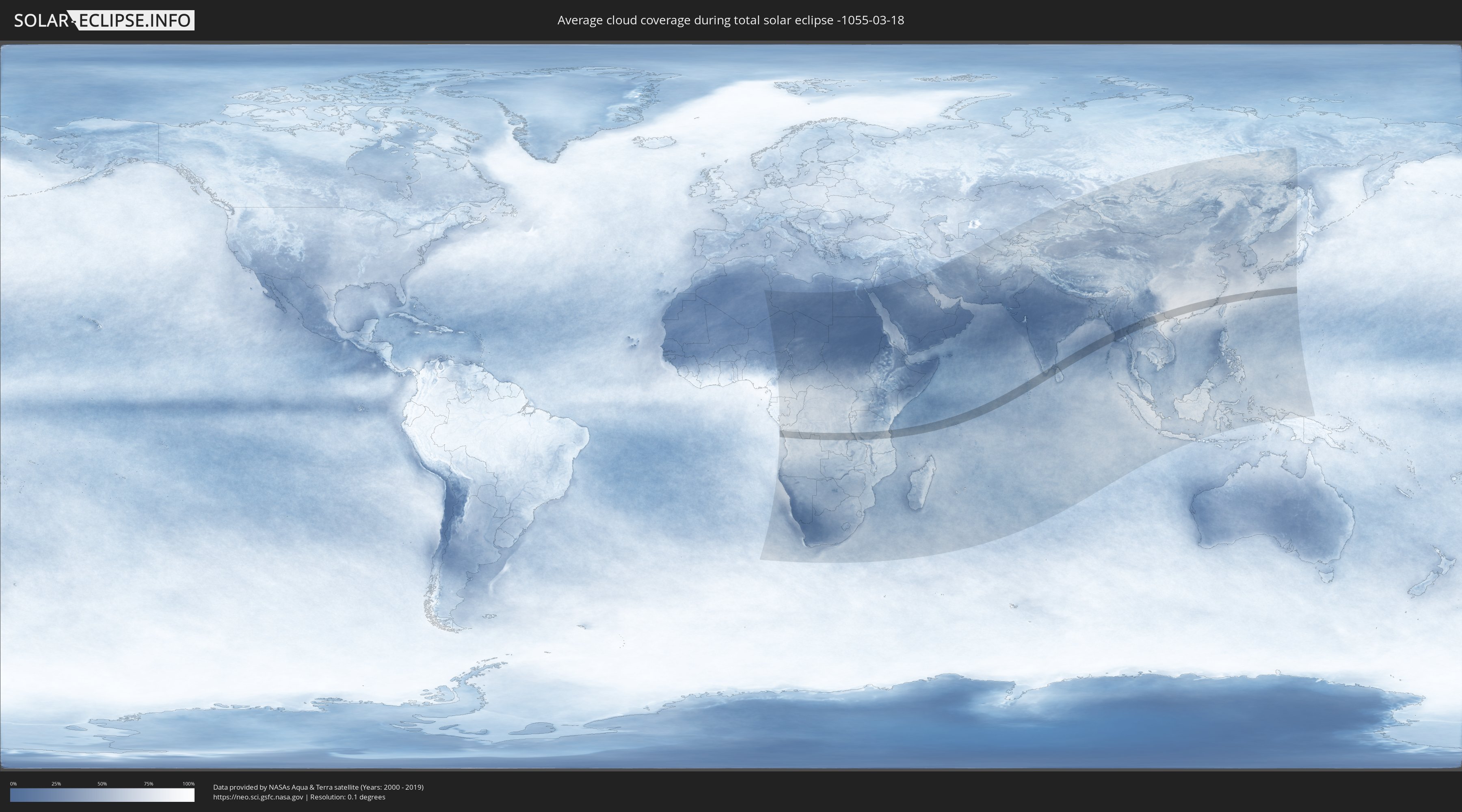
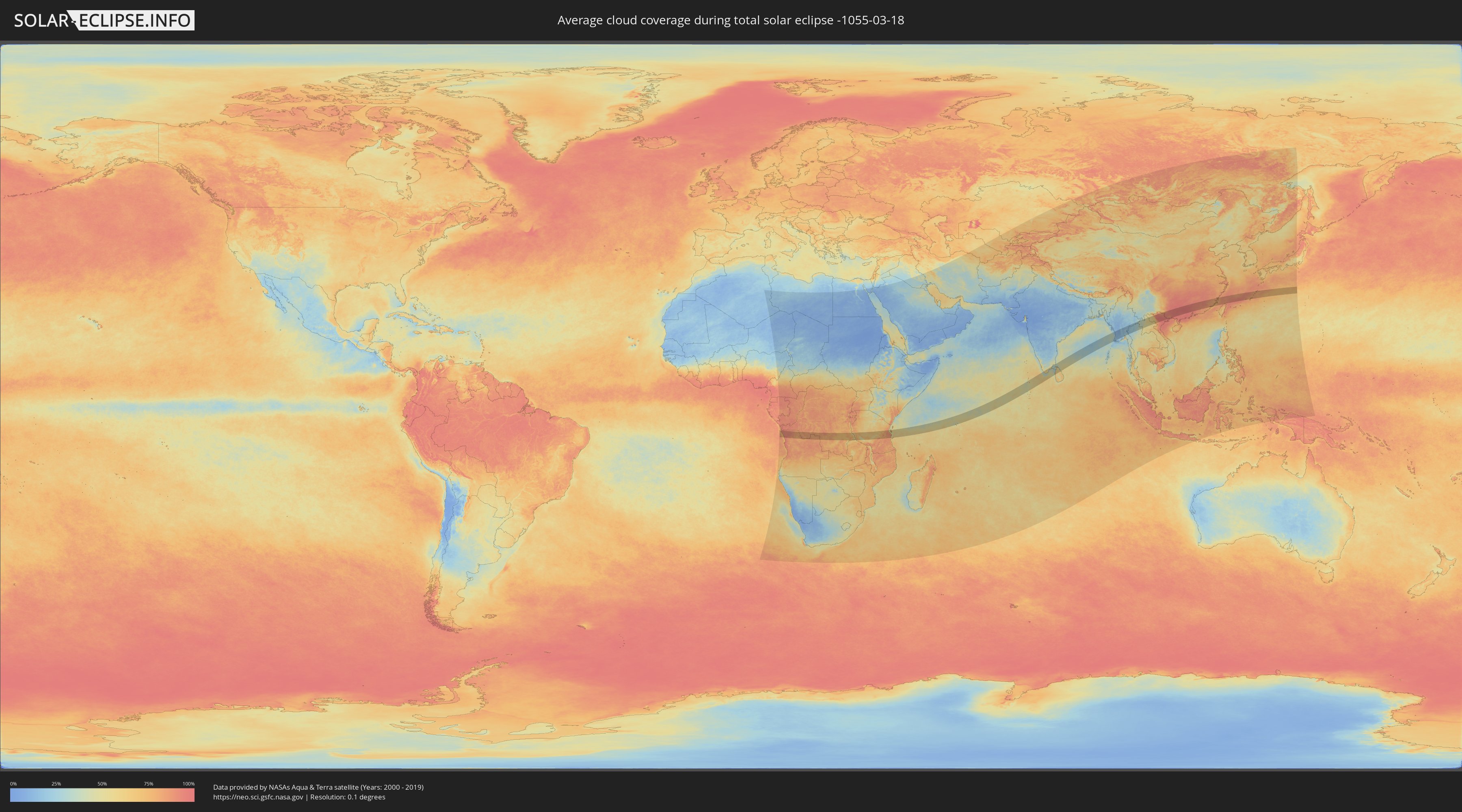
How will be the weather during the total solar eclipse on 03/18/-1055?
Where is the best place to see the total solar eclipse of 03/18/-1055?
The following maps show the average cloud coverage for the day of the total solar eclipse.
With the help of these maps, it is possible to find the place along the eclipse path, which has the best
chance of a cloudless sky.
Nevertheless, you should consider local circumstances and inform about the weather of your chosen
observation site.
The data is provided by NASAs satellites
AQUA and TERRA.
The cloud maps are averaged over a period of 19 years (2000 - 2019).
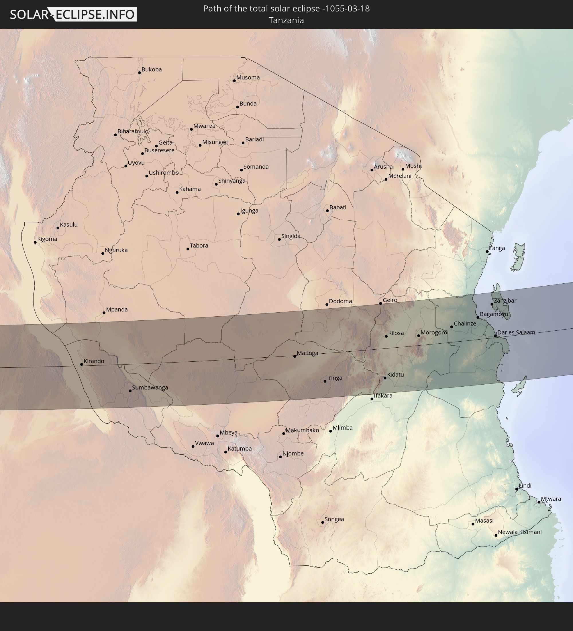
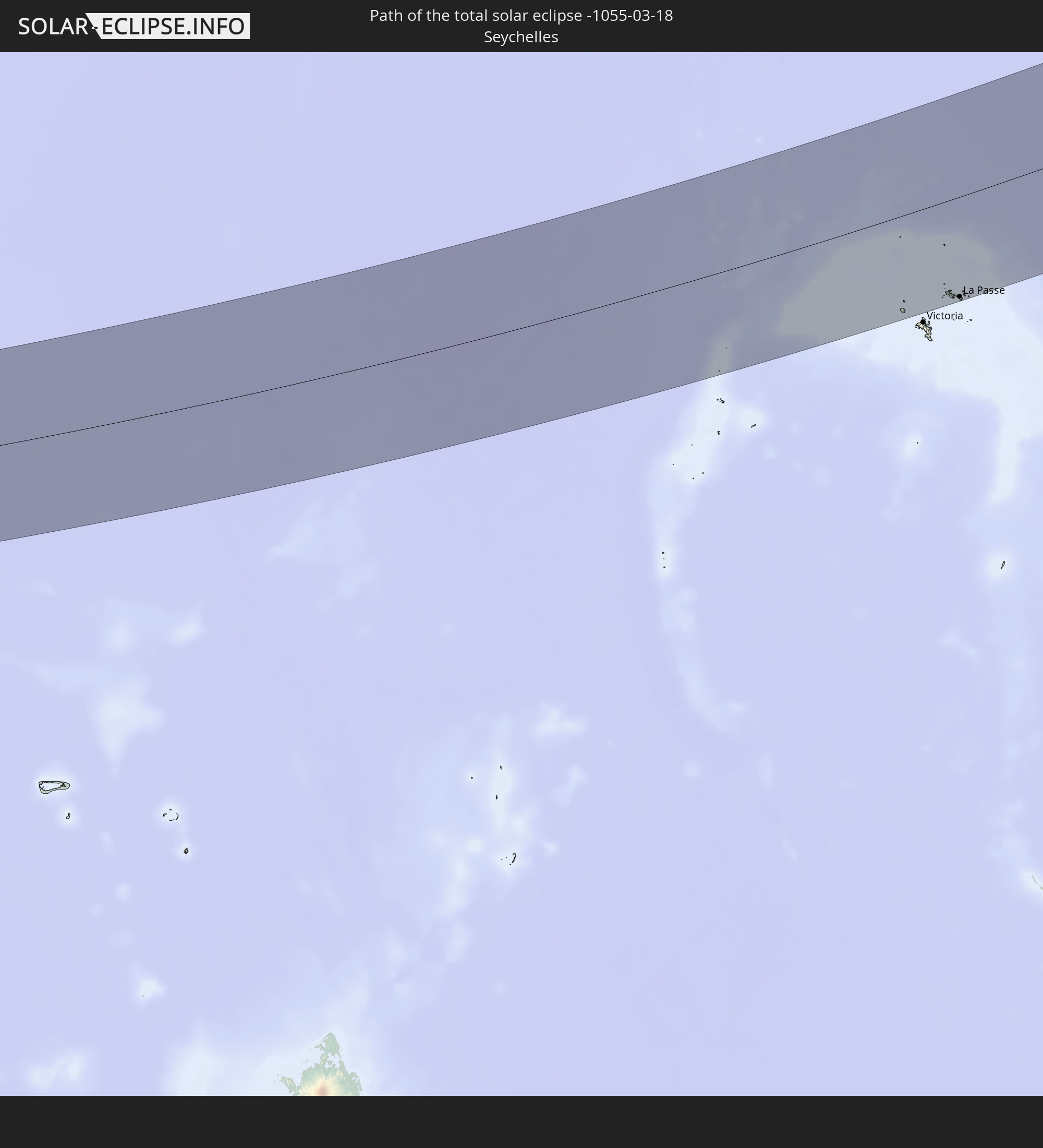
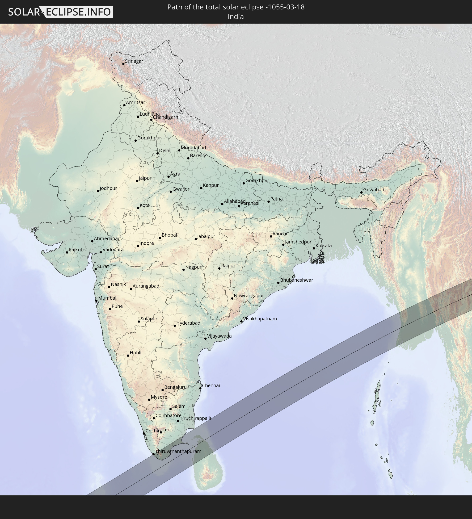
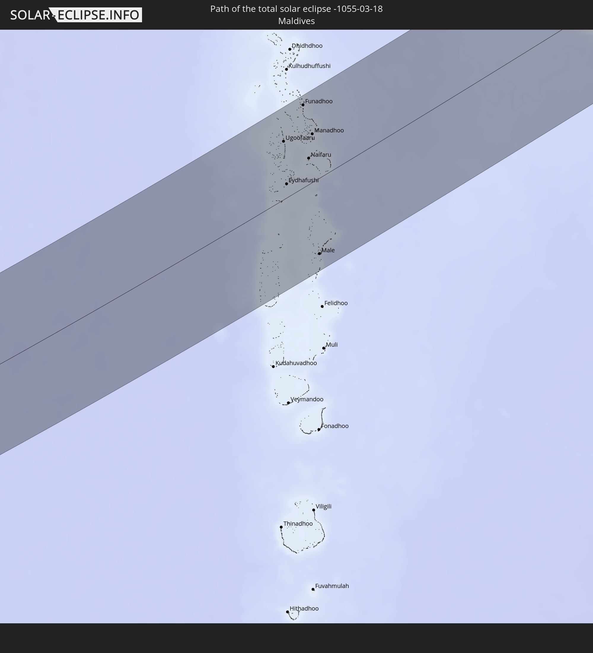
Detailed country maps
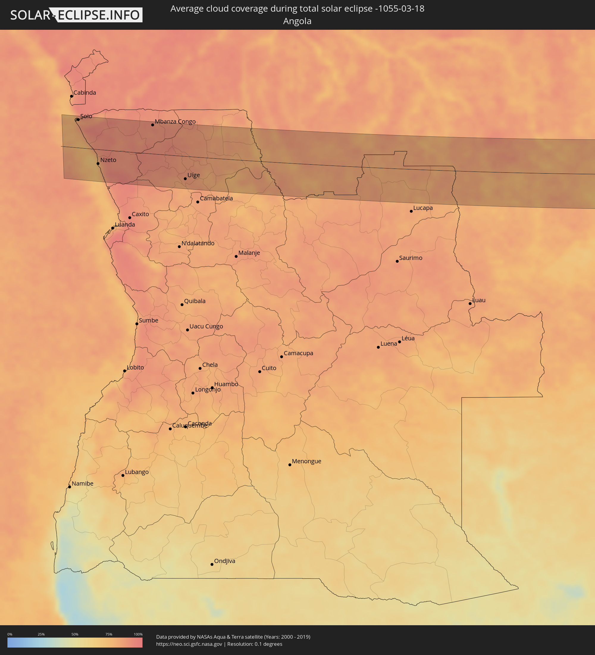 Angola
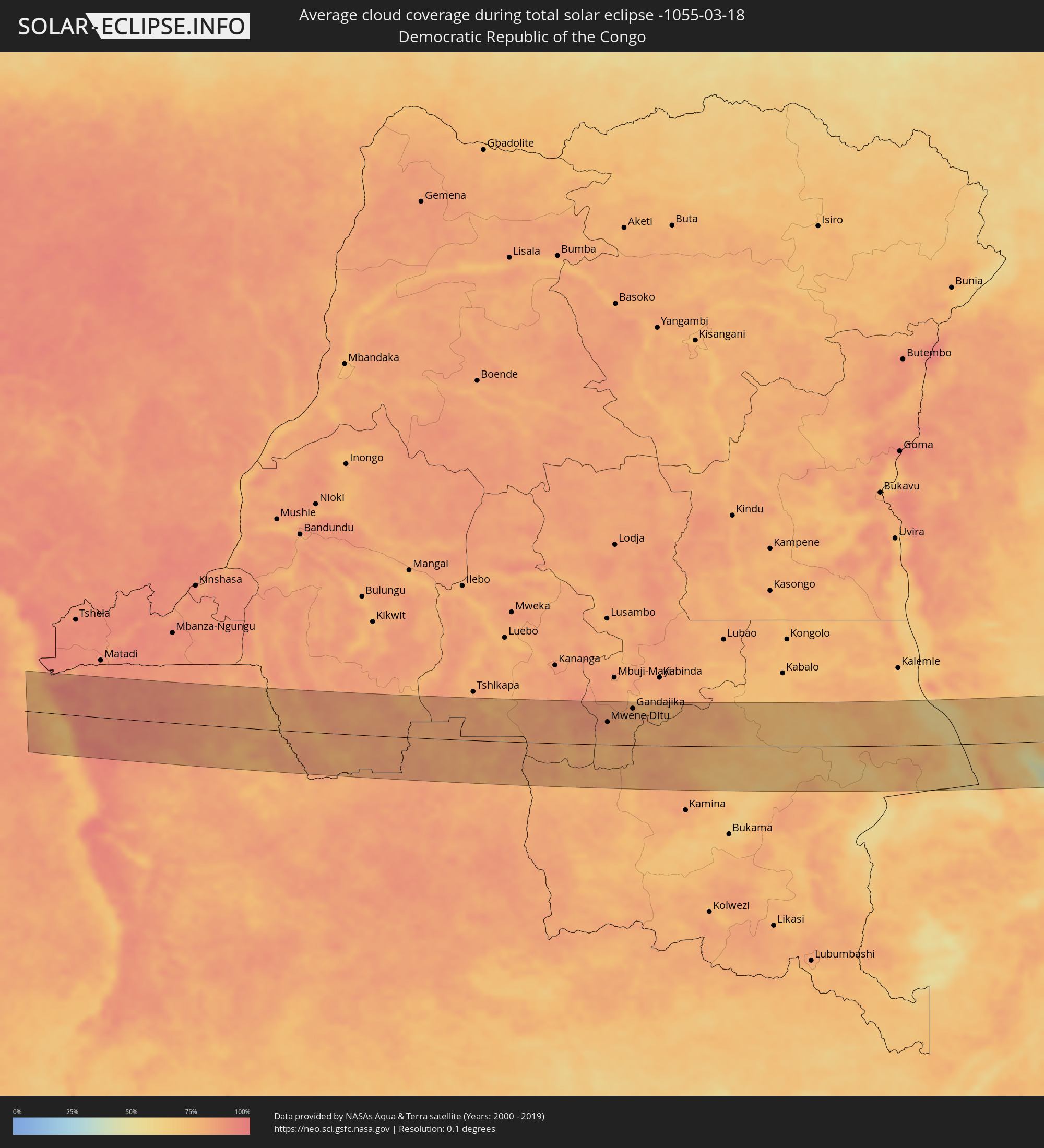 Democratic Republic of the Congo
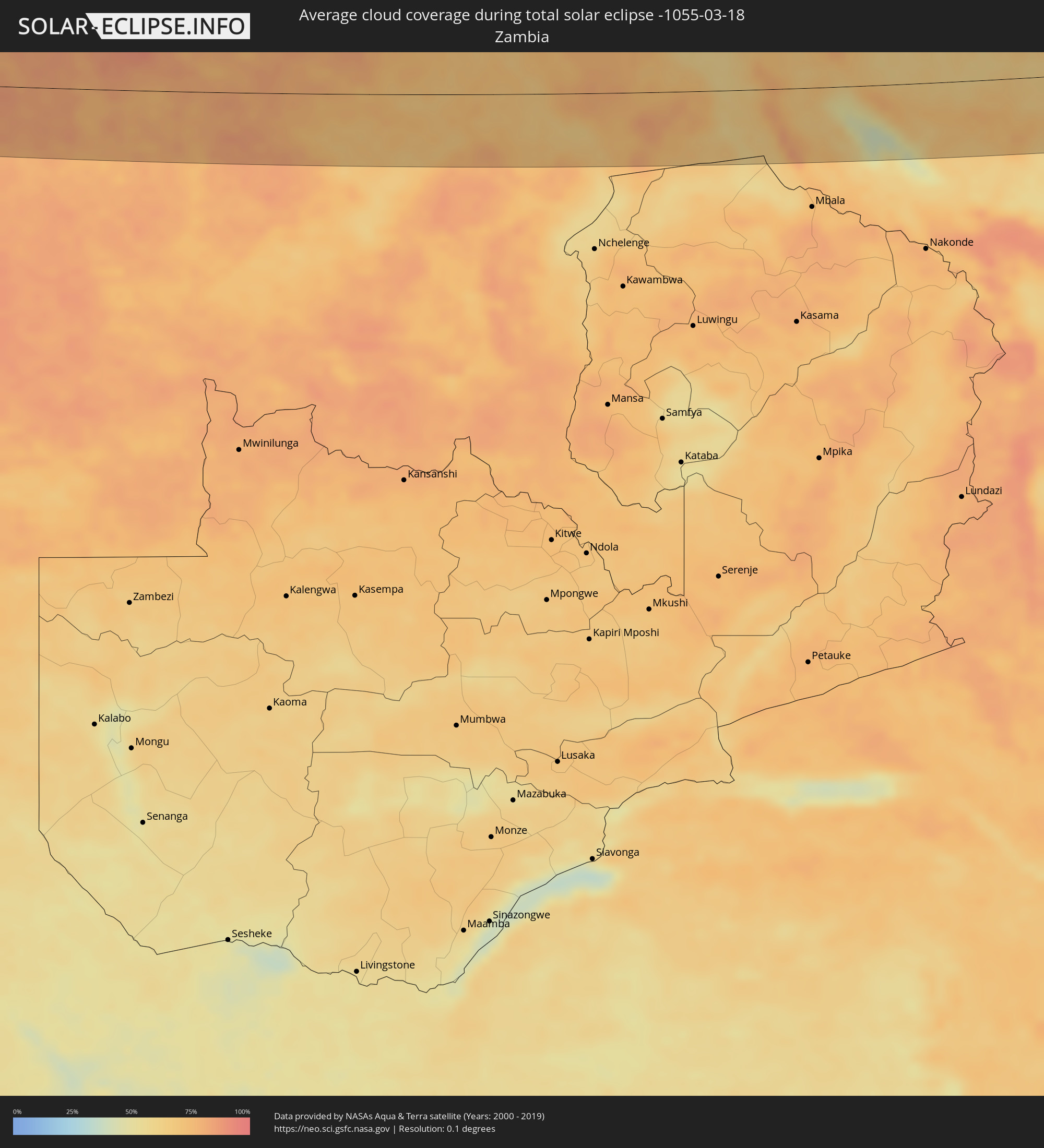 Zambia
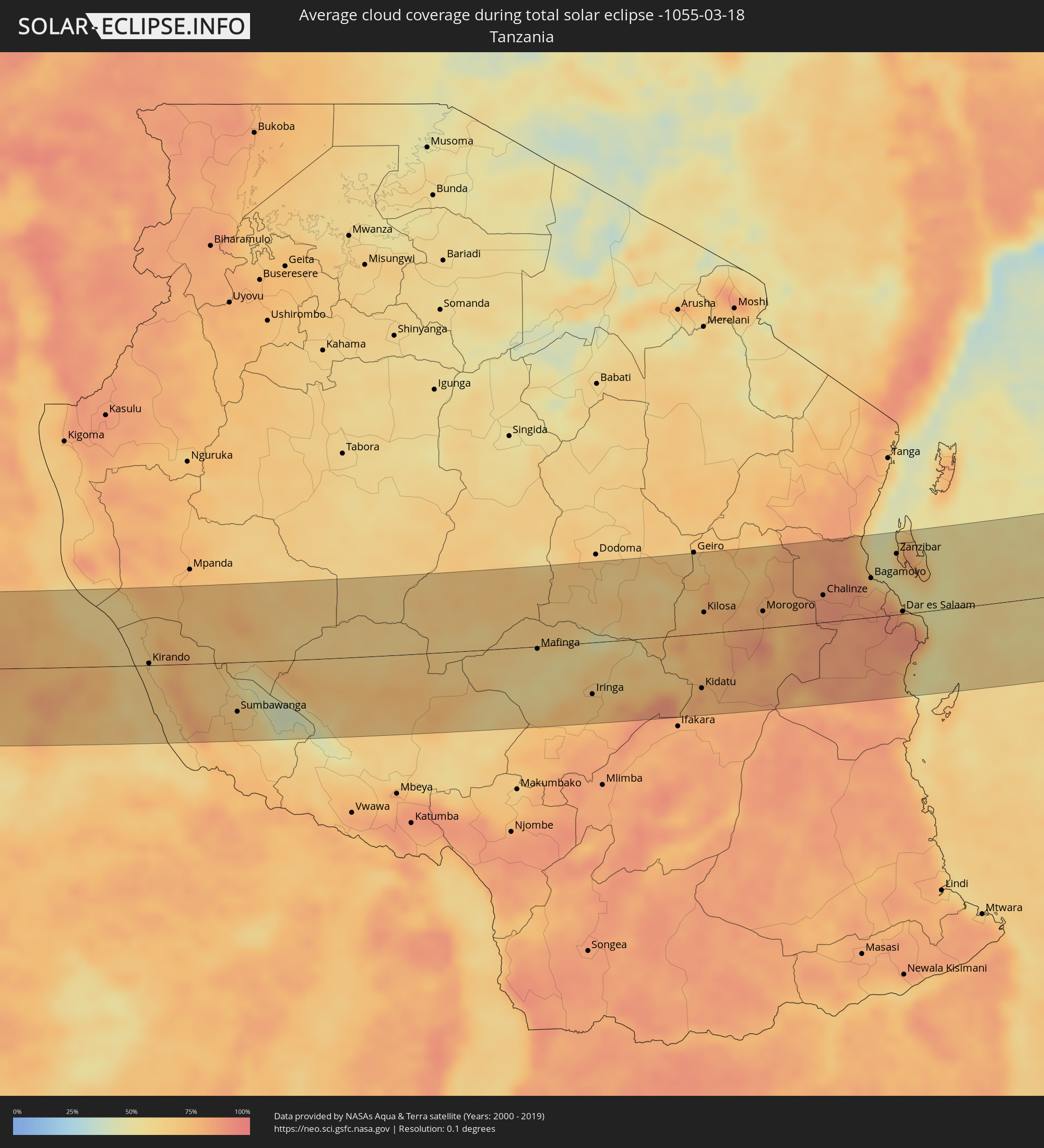 Tanzania
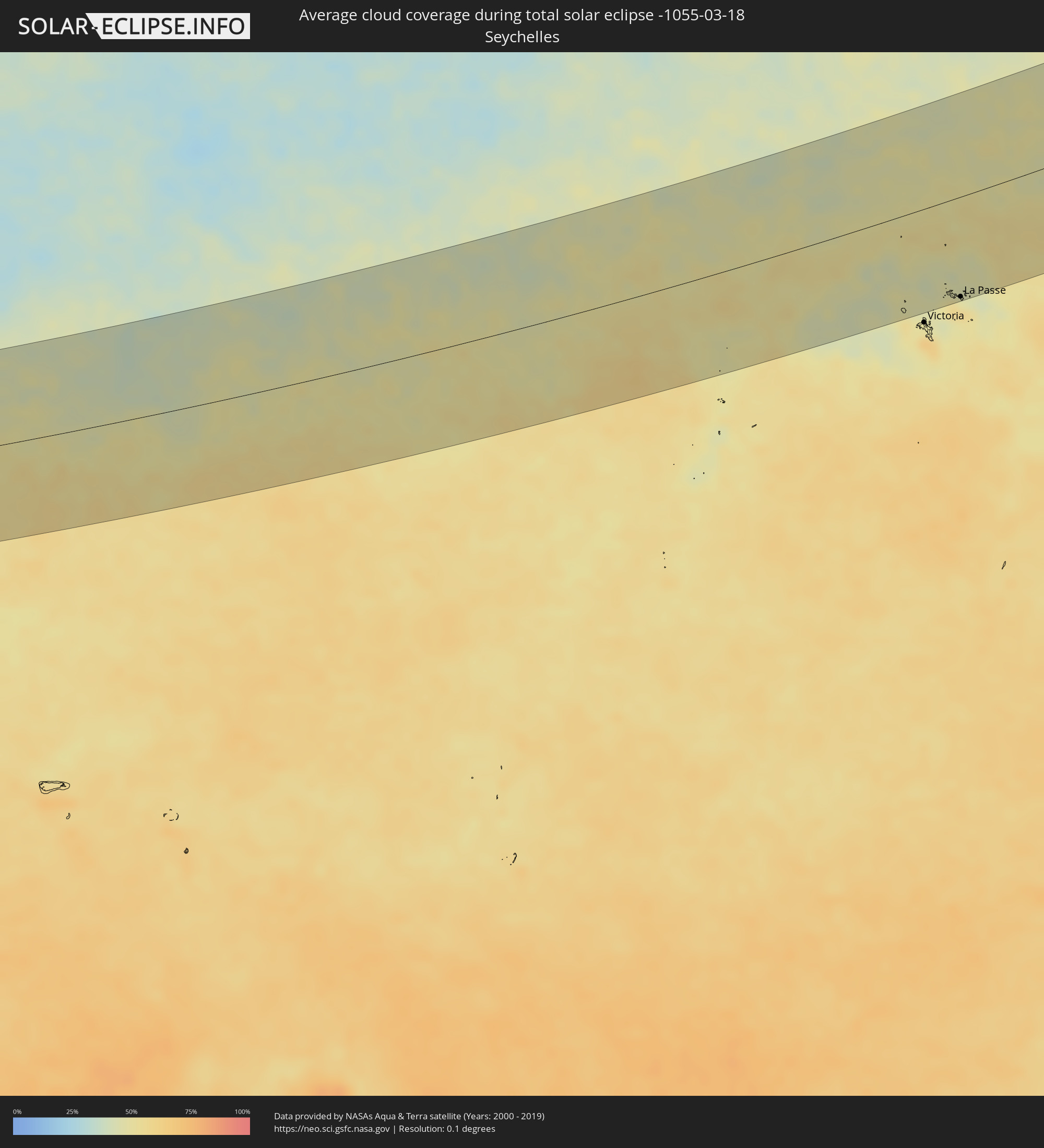 Seychelles
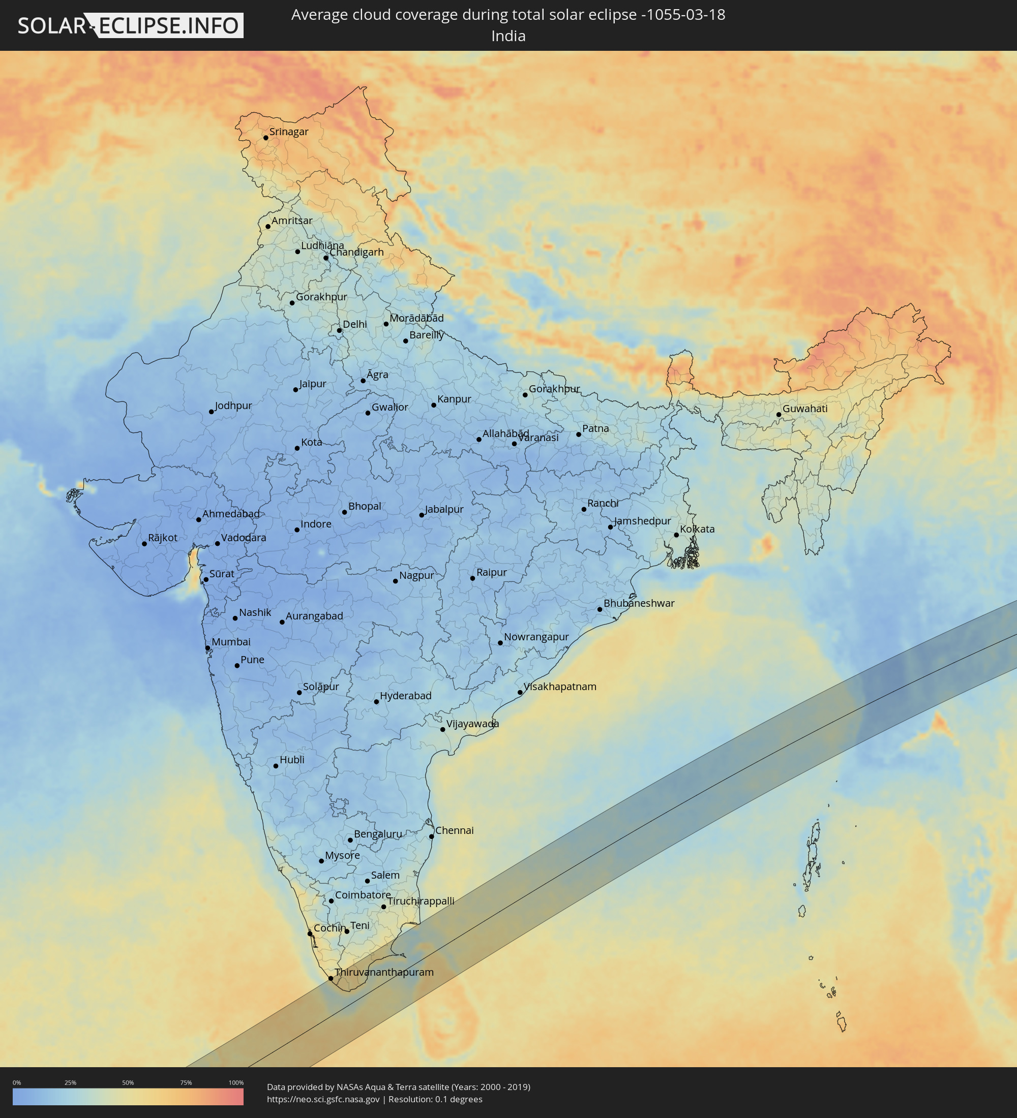 India
India
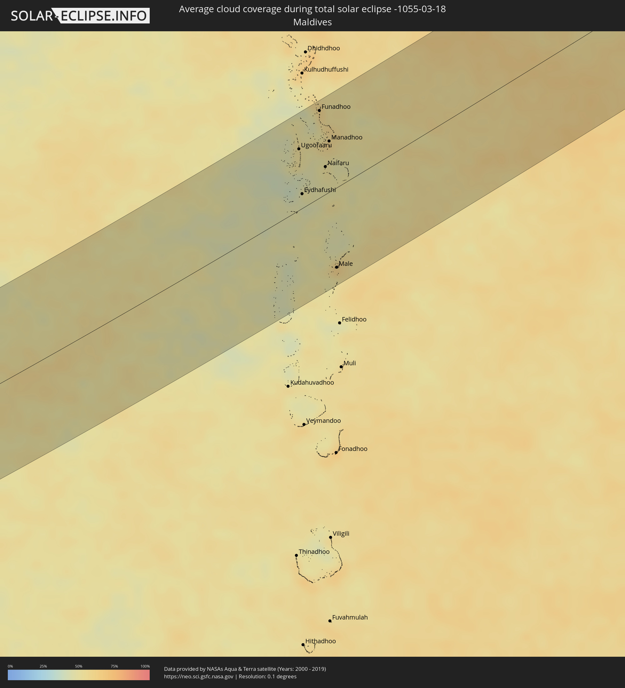 Maldives
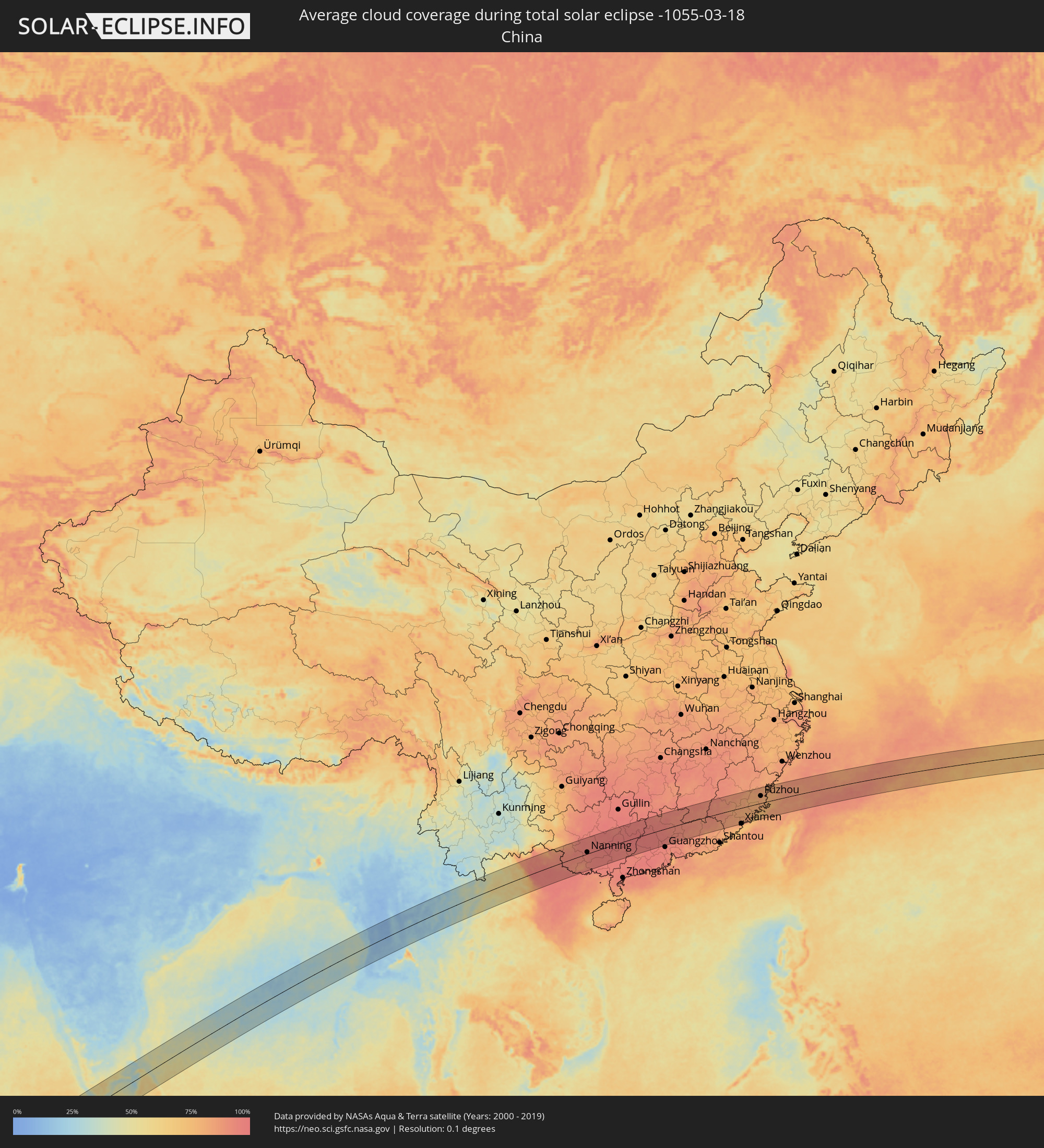 China
China
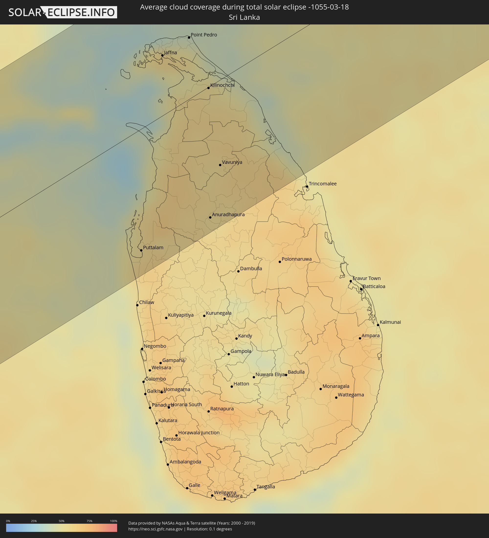 Sri Lanka
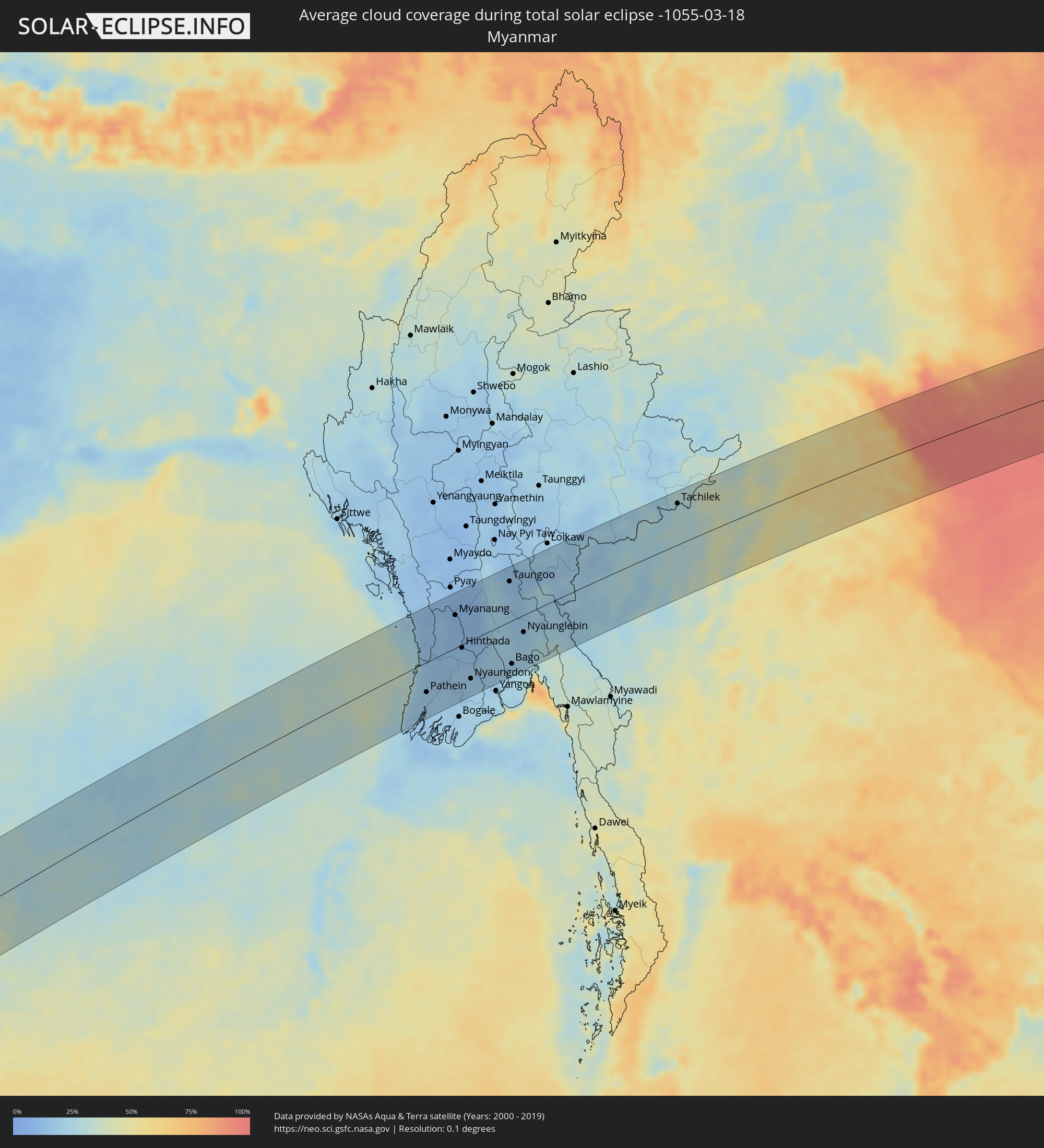 Myanmar
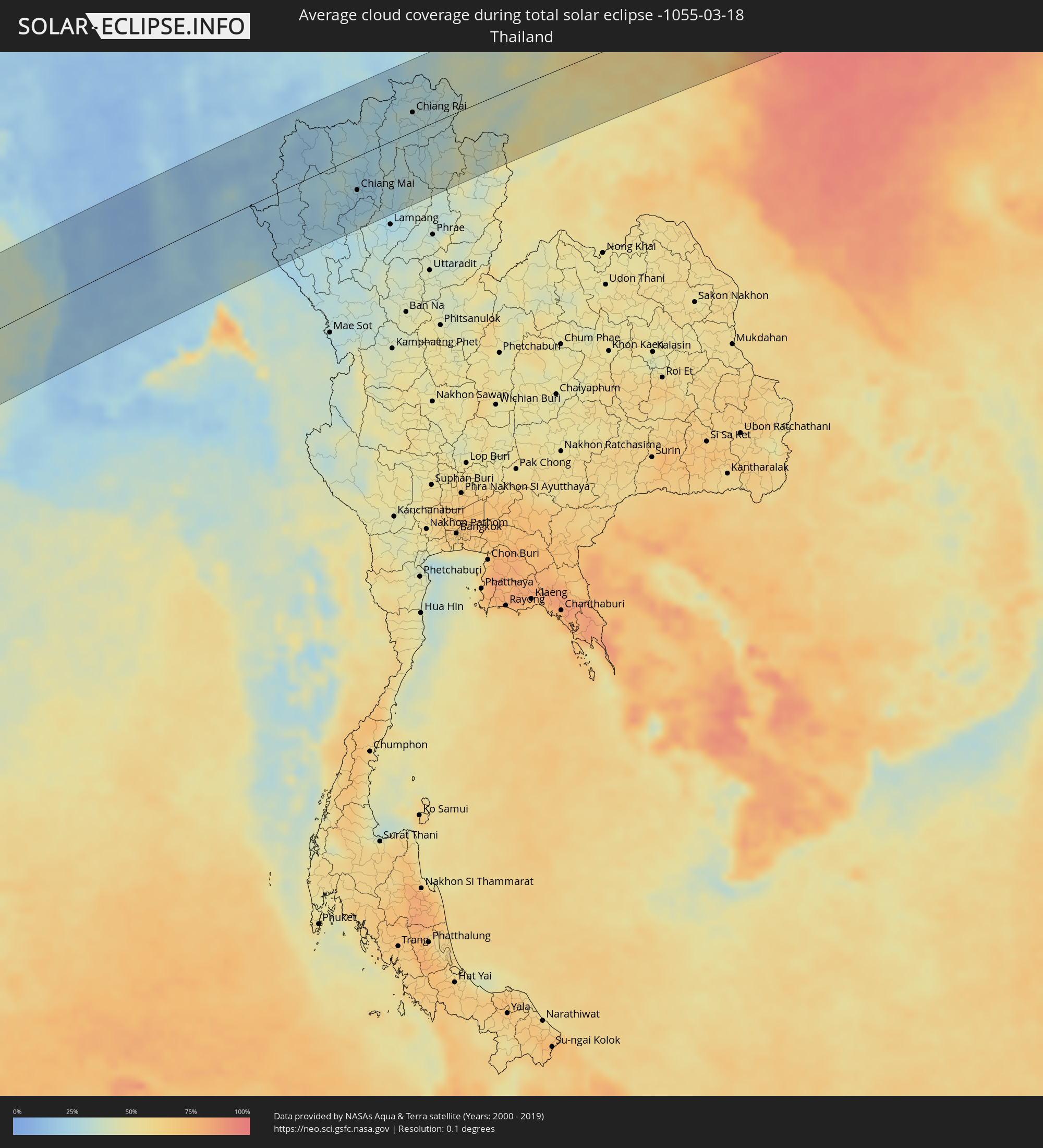 Thailand
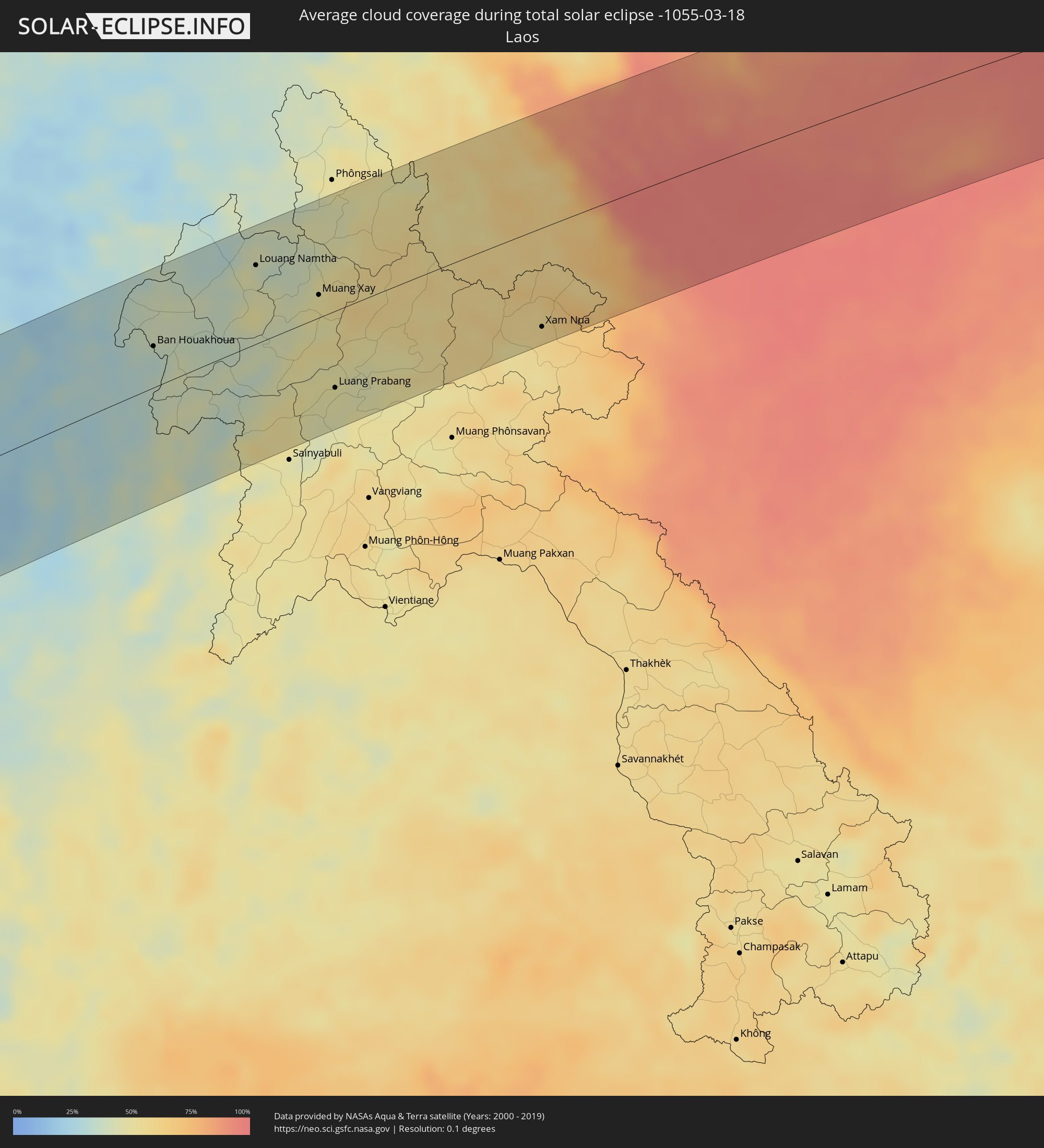 Laos
Laos
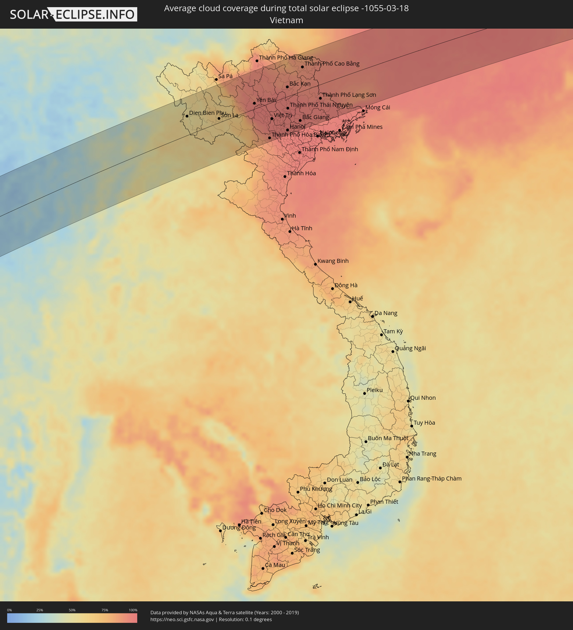 Vietnam
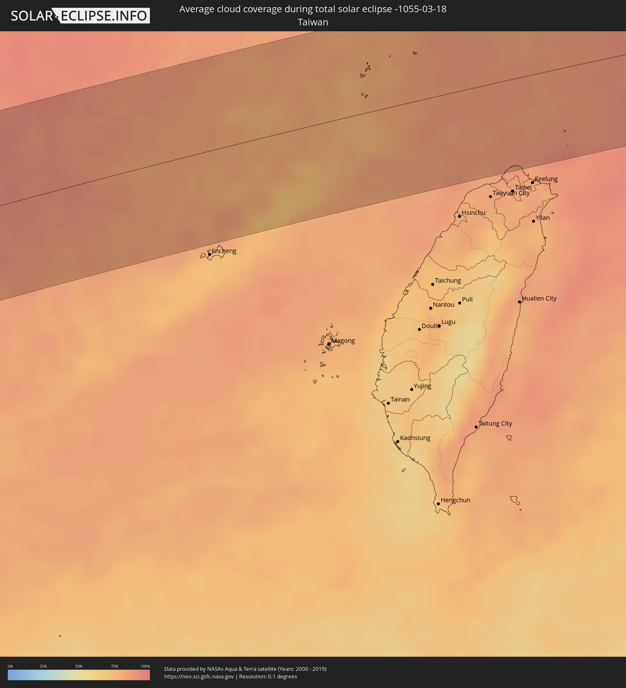 Taiwan
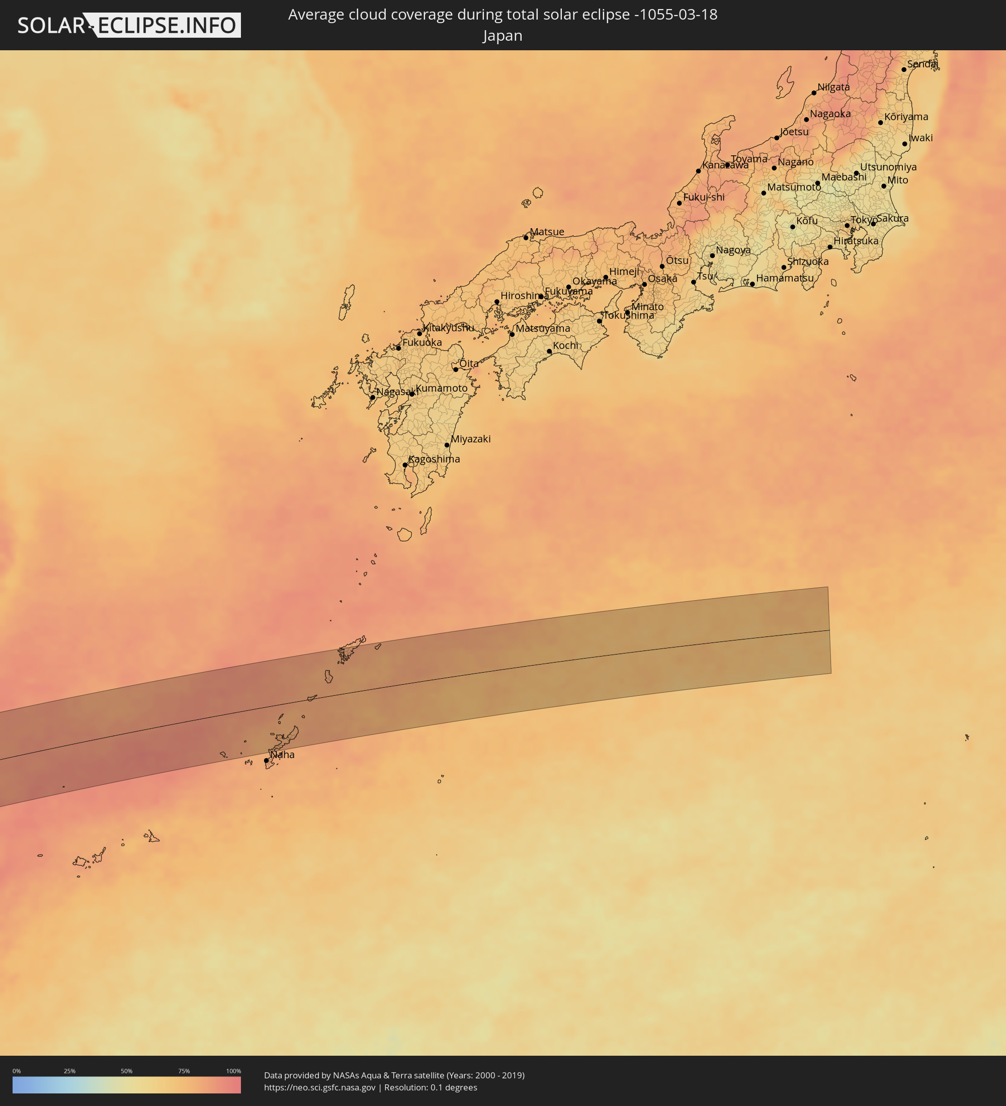 Japan
Japan
Cities inside the path of the eclipse
The following table shows all locations with a population of more than 5,000 inside the eclipse path. Cities which have more than 100,000 inhabitants are marked bold. A click at the locations opens a detailed map.
| City | Type | Eclipse duration | Local time of max. eclipse | Distance to central line | Ø Cloud coverage |
|
Soio, Zaire
|
total | - | 05:36:04 UTC+00:13 | 77 km | 88% |
|
Nzeto, Zaire
|
total | - | 05:35:47 UTC+00:13 | 40 km | 81% |
|
Mbanza Congo, Zaire
|
total | - | 05:36:09 UTC+00:13 | 79 km | 88% |
|
Uíge, Uíge
|
total | - | 05:35:52 UTC+00:13 | 63 km | 84% |
|
Kasongo-Lunda, Bandundu
|
total | - | 05:36:28 UTC+00:13 | 76 km | 77% |
|
Mwene-Ditu, Kasaï-Oriental
|
total | - | 07:35:04 UTC+02:10 | 49 km | 82% |
|
Gandajika, Kasaï-Oriental
|
total | - | 07:35:23 UTC+02:10 | 80 km | 80% |
|
Kirando, Rukwa
|
total | - | 07:55:57 UTC+02:27 | 2 km | 65% |
|
Namanyere, Rukwa
|
total | - | 07:56:14 UTC+02:27 | 10 km | 68% |
|
Sumbawanga, Rukwa
|
total | - | 07:56:29 UTC+02:27 | 63 km | 67% |
|
Mafinga, Iringa
|
total | - | 07:59:44 UTC+02:27 | 3 km | 58% |
|
Iringa, Iringa
|
total | - | 08:00:05 UTC+02:27 | 65 km | 69% |
|
Ilula, Iringa
|
total | - | 08:00:27 UTC+02:27 | 58 km | 73% |
|
Kidatu, Morogoro
|
total | - | 08:01:22 UTC+02:27 | 69 km | 77% |
|
Kilosa, Morogoro
|
total | - | 08:01:50 UTC+02:27 | 27 km | 75% |
|
Morogoro, Morogoro
|
total | - | 08:02:34 UTC+02:27 | 21 km | 82% |
|
Chalinze, Pwani
|
total | - | 08:03:25 UTC+02:27 | 34 km | 88% |
|
Mvomero, Pwani
|
total | - | 08:04:00 UTC+02:27 | 74 km | 83% |
|
Mlandizi, Pwani
|
total | - | 08:03:49 UTC+02:27 | 23 km | 85% |
|
Bagamoyo, Pwani
|
total | - | 08:04:09 UTC+02:27 | 50 km | 67% |
|
Kibiti, Pwani
|
total | - | 08:03:28 UTC+02:27 | 92 km | 88% |
|
Zanzibar, Zanzibar Urban/West
|
total | - | 08:04:39 UTC+02:27 | 77 km | 67% |
|
Dar es Salaam, Dar es Salaam
|
total | - | 08:04:21 UTC+02:27 | 3 km | 77% |
|
La Passe, Inner Islands
|
total | - | 09:47:30 UTC+03:41 | 110 km | 57% |
|
Ugoofaaru, Raa Atoll
|
total | - | 11:55:13 UTC+04:54 | 74 km | 53% |
|
Eydhafushi, Baa Atholhu
|
total | - | 11:54:27 UTC+04:54 | 17 km | 47% |
|
Funadhoo, Shaviyani Atholhu
|
total | - | 11:56:38 UTC+04:54 | 105 km | 60% |
|
Naifaru, Lhaviyani Atholhu
|
total | - | 11:55:45 UTC+04:54 | 33 km | 51% |
|
Manadhoo, Noonu Atoll
|
total | - | 11:56:22 UTC+04:54 | 61 km | 60% |
|
Male, Kaafu Atoll
|
total | - | 11:54:10 UTC+04:54 | 96 km | 61% |
|
Thiruvananthapuram, Kerala
|
total | - | 12:36:48 UTC+05:21 | 114 km | 49% |
|
Neyyāttinkara, Kerala
|
total | - | 12:37:01 UTC+05:21 | 98 km | 52% |
|
Colachel, Tamil Nadu
|
total | - | 12:37:08 UTC+05:21 | 67 km | 52% |
|
Nāgercoil, Tamil Nadu
|
total | - | 12:37:35 UTC+05:21 | 57 km | 53% |
|
Ambasamudram, Tamil Nadu
|
total | - | 12:38:25 UTC+05:21 | 106 km | 56% |
|
Kanniyākumāri, Tamil Nadu
|
total | - | 12:37:43 UTC+05:21 | 42 km | 45% |
|
Kalakkādu, Tamil Nadu
|
total | - | 12:38:23 UTC+05:21 | 81 km | 52% |
|
Vadakku Valliyūr, Tamil Nadu
|
total | - | 12:38:21 UTC+05:21 | 65 km | 54% |
|
Tirunelveli, Tamil Nadu
|
total | - | 12:39:02 UTC+05:21 | 94 km | 60% |
|
Tisaiyanvilai, Tamil Nadu
|
total | - | 12:38:55 UTC+05:21 | 46 km | 47% |
|
Udankudi, Tamil Nadu
|
total | - | 12:39:28 UTC+05:21 | 46 km | 53% |
|
Kayalpattinam, Tamil Nadu
|
total | - | 12:39:55 UTC+05:21 | 54 km | 44% |
|
Keelakarai, Tamil Nadu
|
total | - | 12:42:33 UTC+05:21 | 77 km | 37% |
|
Ramanathapuram, Tamil Nadu
|
total | - | 12:42:52 UTC+05:21 | 88 km | 49% |
|
Tondi, Tamil Nadu
|
total | - | 12:43:52 UTC+05:21 | 112 km | 40% |
|
Rameswaram, Tamil Nadu
|
total | - | 12:43:58 UTC+05:21 | 52 km | 49% |
|
Puttalam, North Western
|
total | - | 12:41:48 UTC+05:19 | 96 km | 59% |
|
Jaffna, Northern Province
|
total | - | 12:44:36 UTC+05:19 | 47 km | 57% |
|
Valvedditturai, Northern Province
|
total | - | 12:45:12 UTC+05:19 | 52 km | 50% |
|
Point Pedro, Northern Province
|
total | - | 12:45:22 UTC+05:19 | 48 km | 50% |
|
Kilinochchi, Northern Province
|
total | - | 12:45:11 UTC+05:19 | 1 km | 54% |
|
Anuradhapura, North Central
|
total | - | 12:43:40 UTC+05:19 | 104 km | 56% |
|
Vavuniya, Northern Province
|
total | - | 12:44:31 UTC+05:19 | 68 km | 56% |
|
Pathein, Ayeyarwady
|
total | - | 14:30:06 UTC+06:24 | 58 km | 18% |
|
Wakema, Ayeyarwady
|
total | - | 14:30:46 UTC+06:24 | 97 km | 17% |
|
Myanaung, Ayeyarwady
|
total | - | 14:32:20 UTC+06:24 | 64 km | 10% |
|
Hinthada, Ayeyarwady
|
total | - | 14:32:05 UTC+06:24 | 6 km | 15% |
|
Paungde, Bago
|
total | - | 14:32:48 UTC+06:24 | 76 km | 10% |
|
Nyaungdon, Ayeyarwady
|
total | - | 14:31:56 UTC+06:24 | 75 km | 17% |
|
Maubin, Ayeyarwady
|
total | - | 14:31:43 UTC+06:24 | 107 km | 19% |
|
Letpandan, Bago
|
total | - | 14:32:43 UTC+06:24 | 6 km | 13% |
|
Tharyarwady, Bago
|
total | - | 14:32:40 UTC+06:24 | 21 km | 14% |
|
Thanatpin, Bago
|
total | - | 14:33:14 UTC+06:24 | 89 km | 21% |
|
Taungoo, Bago
|
total | - | 14:34:43 UTC+06:24 | 79 km | 15% |
|
Pyu, Bago
|
total | - | 14:34:24 UTC+06:24 | 32 km | 18% |
|
Bago, Bago
|
total | - | 14:33:39 UTC+06:24 | 85 km | 22% |
|
Thanatpin, Bago
|
total | - | 14:33:46 UTC+06:24 | 93 km | 22% |
|
Nyaunglebin, Bago
|
total | - | 14:34:31 UTC+06:24 | 34 km | 17% |
|
Chom Thong, Chiang Mai
|
total | - | 14:55:22 UTC+06:42 | 74 km | 21% |
|
San Pa Tong, Chiang Mai
|
total | - | 14:55:51 UTC+06:42 | 62 km | 21% |
|
Hang Dong, Chiang Mai
|
total | - | 14:55:56 UTC+06:42 | 57 km | 21% |
|
Pa Sang, Lamphun
|
total | - | 14:55:51 UTC+06:42 | 74 km | 23% |
|
Chiang Mai, Chiang Mai
|
total | - | 14:56:06 UTC+06:42 | 50 km | 22% |
|
Lamphun, Lamphun
|
total | - | 14:56:00 UTC+06:42 | 72 km | 22% |
|
San Kamphaeng, Chiang Mai
|
total | - | 14:56:17 UTC+06:42 | 60 km | 23% |
|
Chiang Rai, Chiang Rai
|
total | - | 14:58:05 UTC+06:42 | 28 km | 29% |
|
Mae Chan, Chiang Rai
|
total | - | 14:58:15 UTC+06:42 | 52 km | 30% |
|
Mae Sai, Chiang Rai
|
total | - | 14:58:26 UTC+06:42 | 80 km | 31% |
|
Tachilek, Shan
|
total | - | 14:58:27 UTC+06:42 | 81 km | 31% |
|
Pa Daet, Chiang Rai
|
total | - | 14:58:06 UTC+06:42 | 20 km | 28% |
|
Dok Kham Tai, Phayao
|
total | - | 14:57:54 UTC+06:42 | 55 km | 29% |
|
Pong, Phayao
|
total | - | 14:58:20 UTC+06:42 | 68 km | 35% |
|
Chiang Kham, Phayao
|
total | - | 14:58:35 UTC+06:42 | 31 km | 34% |
|
Chiang Khong, Chiang Rai
|
total | - | 14:59:09 UTC+06:42 | 40 km | 34% |
|
Ban Houayxay, Bokeo Province
|
total | - | 14:59:10 UTC+06:42 | 41 km | 34% |
|
Ban Houakhoua, Bokeo Province
|
total | - | 14:59:13 UTC+06:42 | 37 km | 33% |
|
Chiang Klang, Nan
|
total | - | 14:59:18 UTC+06:42 | 78 km | 34% |
|
Louang Namtha, Loungnamtha
|
total | - | 15:00:57 UTC+06:42 | 70 km | 44% |
|
Muang Xay, Oudômxai
|
total | - | 15:01:40 UTC+06:42 | 20 km | 51% |
|
Luang Prabang, Louangphabang
|
total | - | 15:01:29 UTC+06:42 | 69 km | 48% |
|
Dien Bien Phu, Tỉnh Ðiện Biên
|
total | - | 15:28:01 UTC+07:06 | 51 km | 54% |
|
Sơn La, Sơn La
|
total | - | 15:29:12 UTC+07:06 | 11 km | 60% |
|
Xam Nua, Houaphan
|
total | - | 15:04:24 UTC+06:42 | 89 km | 59% |
|
Yên Bái, Yên Bái
|
total | - | 15:30:39 UTC+07:06 | 15 km | 96% |
|
Thành Phố Tuyên Quang, Tuyên Quang
|
total | - | 15:31:04 UTC+07:06 | 14 km | 97% |
|
Thành Phố Hòa Bình, Hòa Bình
|
total | - | 15:30:51 UTC+07:06 | 95 km | 86% |
|
Việt Trì, Phú Thọ
|
total | - | 15:31:07 UTC+07:06 | 45 km | 95% |
|
Sơn Tây, Ha Nội
|
total | - | 15:31:11 UTC+07:06 | 68 km | 96% |
|
Vĩnh Yên, Vĩnh Phúc
|
total | - | 15:31:22 UTC+07:06 | 54 km | 96% |
|
Hà Đông, Ha Nội
|
total | - | 15:31:28 UTC+07:06 | 95 km | 95% |
|
Bắc Kạn, Bắc Kạn
|
total | - | 15:31:57 UTC+07:06 | 25 km | 95% |
|
Hanoi, Ha Nội
|
total | - | 15:31:34 UTC+07:06 | 92 km | 95% |
|
Thành Phố Thái Nguyên, Thái Nguyên
|
total | - | 15:31:47 UTC+07:06 | 33 km | 96% |
|
Bắc Ninh, Bắc Ninh
|
total | - | 15:31:55 UTC+07:06 | 84 km | 96% |
|
Bắc Giang, Bắc Giang
|
total | - | 15:32:06 UTC+07:06 | 79 km | 96% |
|
Thành Phố Cao Bằng, Cao Bằng
|
total | - | 15:32:38 UTC+07:06 | 64 km | 89% |
|
Thành Phố Lạng Sơn, Lạng Sơn
|
total | - | 15:32:59 UTC+07:06 | 38 km | 94% |
|
Nanning, Guangxi Zhuang Autonomous Region
|
total | - | 16:28:23 UTC+08:00 | 9 km | 94% |
|
Qinzhou, Guangxi Zhuang Autonomous Region
|
total | - | 16:28:31 UTC+08:00 | 90 km | 94% |
|
Yulin, Guangxi Zhuang Autonomous Region
|
total | - | 16:30:20 UTC+08:00 | 70 km | 95% |
|
Wuzhou, Guangxi Zhuang Autonomous Region
|
total | - | 16:31:41 UTC+08:00 | 16 km | 97% |
|
Yunfu, Guangdong
|
total | - | 16:32:17 UTC+08:00 | 97 km | 97% |
|
Lubu, Guangdong
|
total | - | 16:32:34 UTC+08:00 | 79 km | 97% |
|
Zhaoqing, Guangdong
|
total | - | 16:32:43 UTC+08:00 | 97 km | 96% |
|
Sanshui, Guangdong
|
total | - | 16:33:08 UTC+08:00 | 99 km | 95% |
|
Qingyuan, Guangdong
|
total | - | 16:33:21 UTC+08:00 | 45 km | 96% |
|
Lecheng, Guangdong
|
total | - | 16:33:46 UTC+08:00 | 98 km | 93% |
|
Shaoguan, Guangdong
|
total | - | 16:33:57 UTC+08:00 | 57 km | 94% |
|
Meizhou, Guangdong
|
total | - | 16:36:01 UTC+08:00 | 66 km | 85% |
|
Zhangzhou, Fujian
|
total | - | 16:37:12 UTC+08:00 | 83 km | 83% |
|
Quanzhou, Fujian
|
total | - | 16:37:52 UTC+08:00 | 63 km | 84% |
|
Putian, Fujian
|
total | - | 16:38:09 UTC+08:00 | 16 km | 82% |
|
Fuzhou, Fujian
|
total | - | 16:38:19 UTC+08:00 | 44 km | 82% |
|
Ishikawa, Okinawa
|
total | - | 17:42:34 UTC+09:00 | 90 km | 83% |
|
Nago, Okinawa
|
total | - | 17:42:36 UTC+09:00 | 72 km | 81% |