Annular solar eclipse of 04/29/-1113
| Day of week: | Sunday |
| Maximum duration of eclipse: | 01m33s |
| Maximum width of eclipse path: | 53 km |
| Saros cycle: | 30 |
| Coverage: | 98.6% |
| Magnitude: | 0.9855 |
| Gamma: | 0.281 |
Wo kann man die Sonnenfinsternis vom 04/29/-1113 sehen?
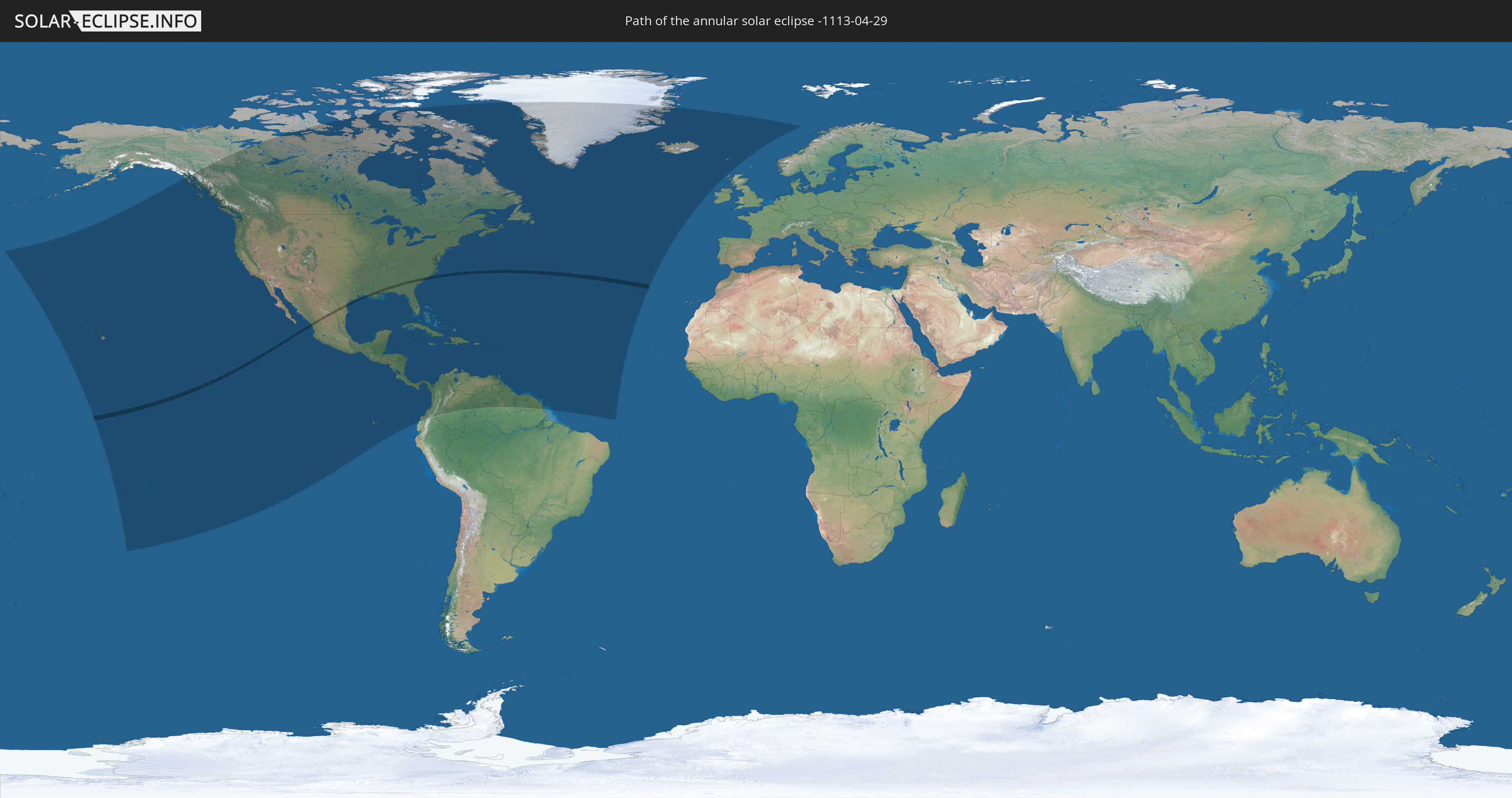
Die Sonnenfinsternis am 04/29/-1113 kann man in 54 Ländern als partielle Sonnenfinsternis beobachten.
Der Finsternispfad verläuft durch 2 Länder. Nur in diesen Ländern ist sie als annular Sonnenfinsternis zu sehen.
In den folgenden Ländern ist die Sonnenfinsternis annular zu sehen
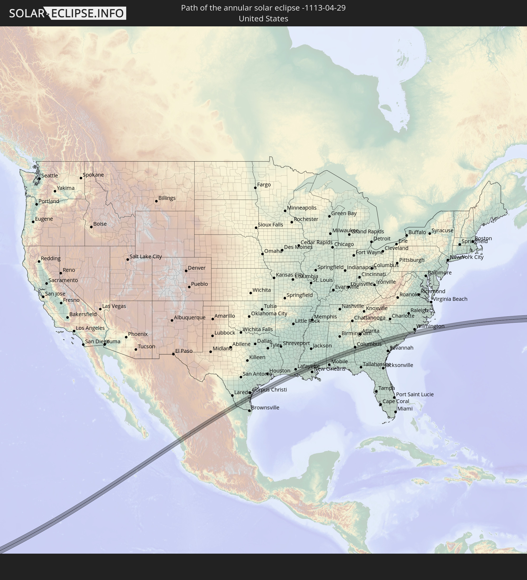 United States
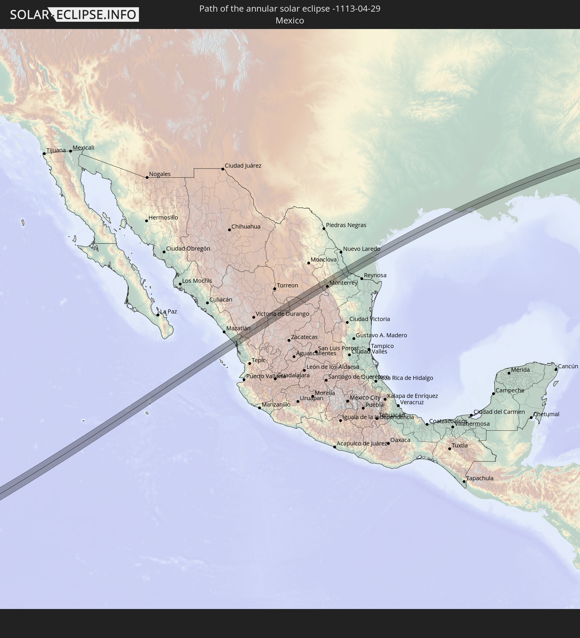 Mexico
In den folgenden Ländern ist die Sonnenfinsternis partiell zu sehen
 United States
 United States Minor Outlying Islands
 Kiribati
 French Polynesia
 Canada
 Pitcairn Islands
 Mexico
 Greenland
 Guatemala
 Ecuador
 El Salvador
 Honduras
 Belize
 Nicaragua
 Costa Rica
 Cuba
Cuba
 Panama
 Colombia
 Cayman Islands
 The Bahamas
 Jamaica
 Haiti
Haiti
 Brazil
 Venezuela
 Turks and Caicos Islands
 Dominican Republic
 Aruba
Aruba
 Puerto Rico
 United States Virgin Islands
 Bermuda
 British Virgin Islands
 Anguilla
 Collectivity of Saint Martin
 Saint Barthélemy
 Saint Kitts and Nevis
 Antigua and Barbuda
 Montserrat
 Trinidad and Tobago
 Guadeloupe
 Grenada
 Dominica
 Saint Vincent and the Grenadines
 Guyana
 Martinique
 Saint Lucia
 Barbados
 Suriname
 Saint Pierre and Miquelon
 French Guiana
 Portugal
 Iceland
 Svalbard and Jan Mayen
 United Kingdom
 Faroe Islands
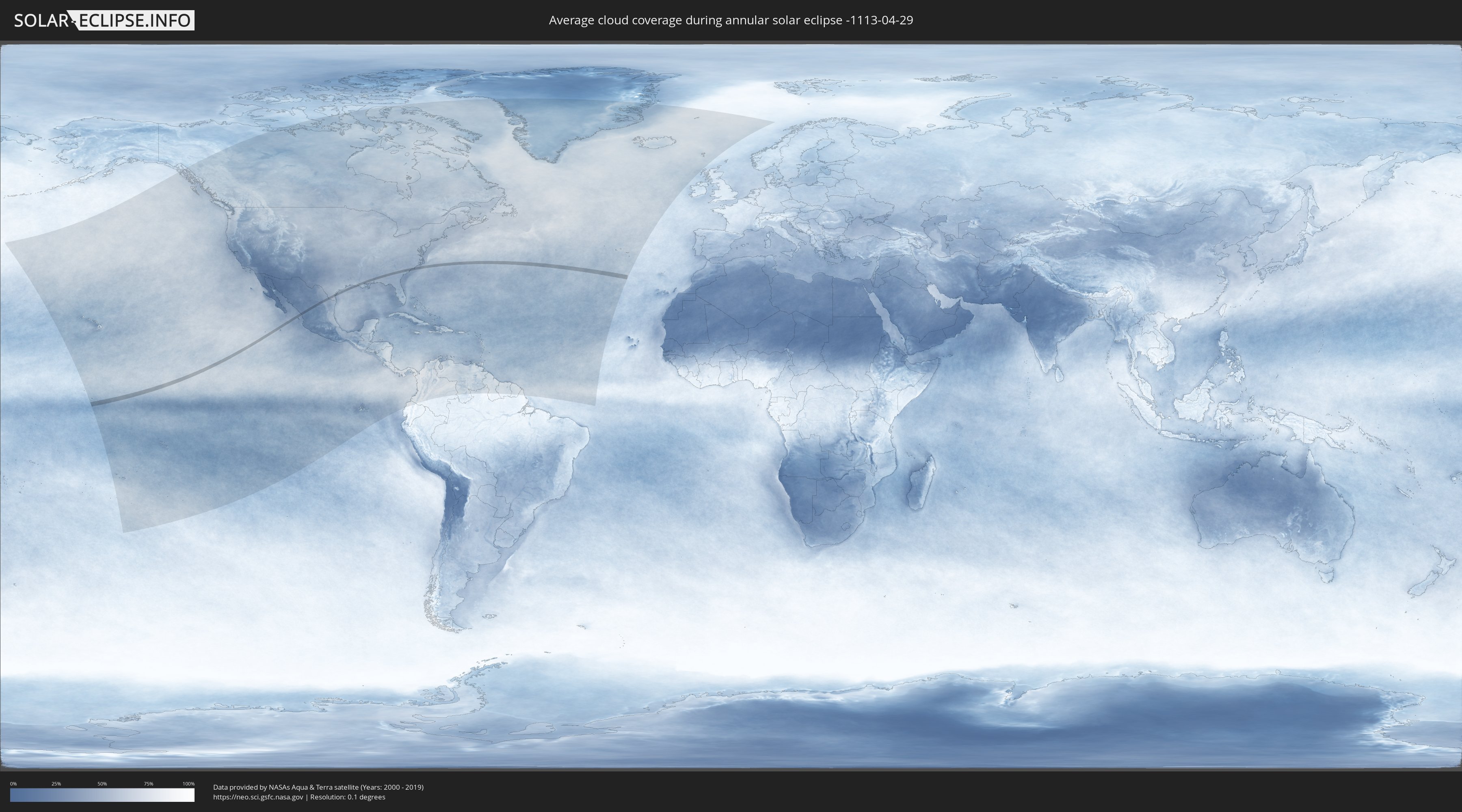
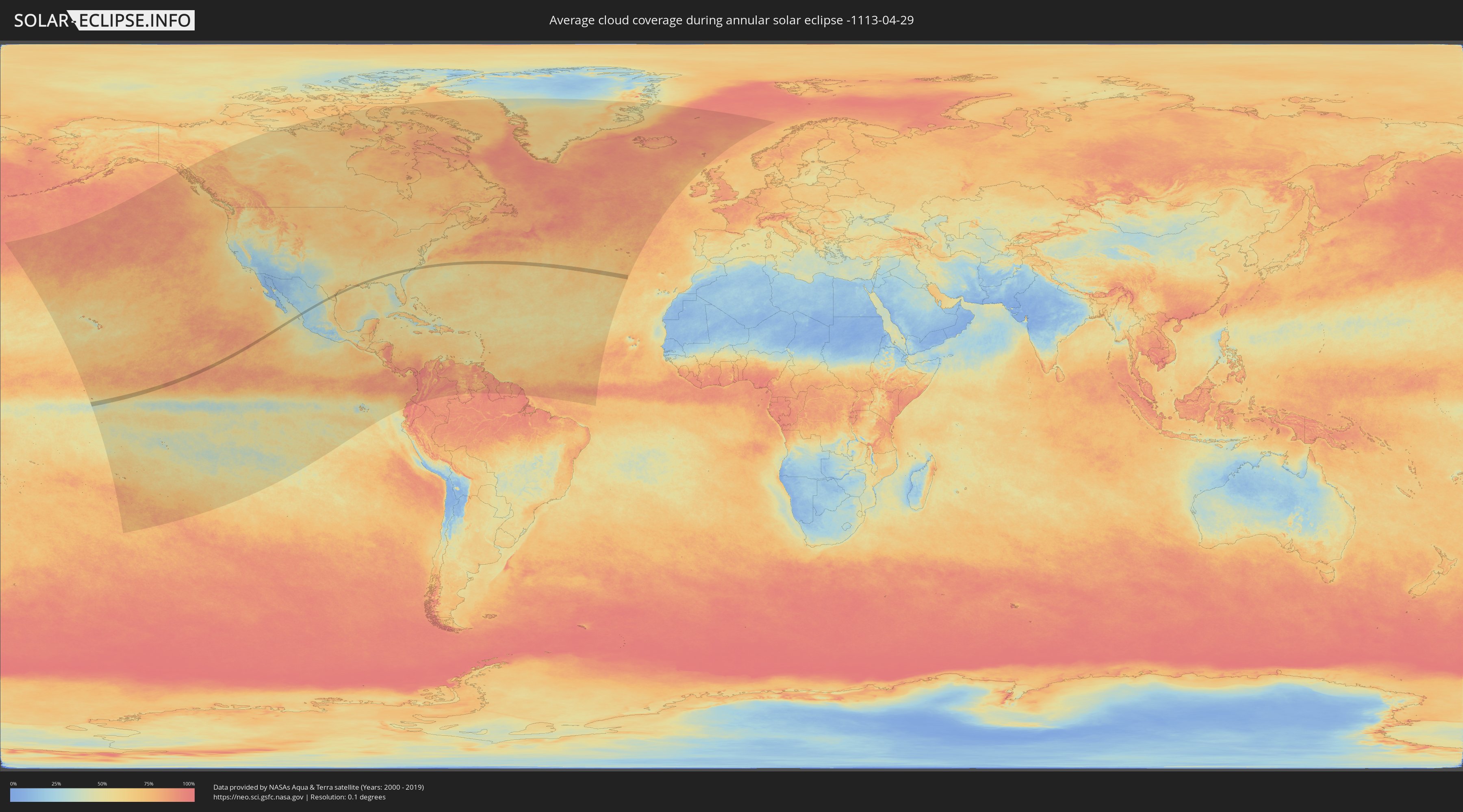
How will be the weather during the annular solar eclipse on 04/29/-1113?
Where is the best place to see the annular solar eclipse of 04/29/-1113?
The following maps show the average cloud coverage for the day of the annular solar eclipse.
With the help of these maps, it is possible to find the place along the eclipse path, which has the best
chance of a cloudless sky.
Nevertheless, you should consider local circumstances and inform about the weather of your chosen
observation site.
The data is provided by NASAs satellites
AQUA and TERRA.
The cloud maps are averaged over a period of 19 years (2000 - 2019).
Detailed country maps
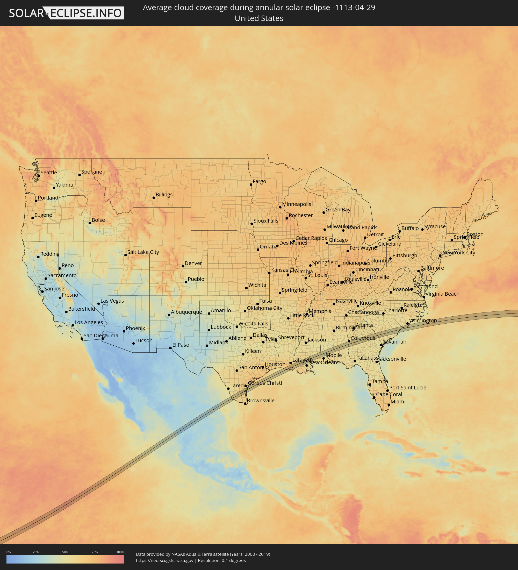 United States
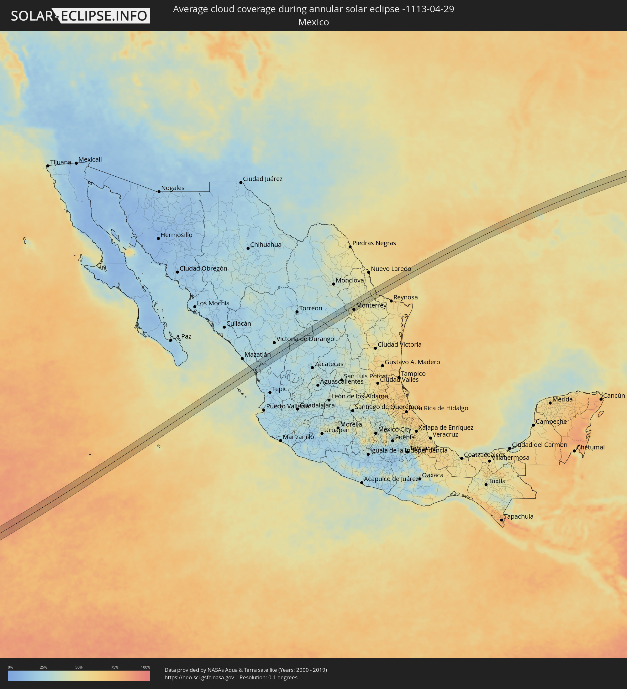 Mexico
Cities inside the path of the eclipse
The following table shows all locations with a population of more than 5,000 inside the eclipse path. Cities which have more than 100,000 inhabitants are marked bold. A click at the locations opens a detailed map.
| City | Type | Eclipse duration | Local time of max. eclipse | Distance to central line | Ø Cloud coverage |
|
Isla del Bosque, Sinaloa
|
annular | - | 10:47:46 UTC-07:05 | 4 km | 33% |
|
Escuinapa de Hidalgo, Sinaloa
|
annular | - | 10:48:07 UTC-07:05 | 9 km | 28% |
|
Vicente Guerrero, Durango
|
annular | - | 11:23:19 UTC-06:36 | 6 km | 25% |
|
Miguel Auza, Zacatecas
|
annular | - | 11:25:42 UTC-06:36 | 17 km | 26% |
|
Juan Aldama, Zacatecas
|
annular | - | 11:25:50 UTC-06:36 | 14 km | 27% |
|
Saltillo, Coahuila
|
annular | - | 11:33:58 UTC-06:36 | 7 km | 39% |
|
Ramos Arizpe, Coahuila
|
annular | - | 11:34:19 UTC-06:36 | 1 km | 36% |
|
Arteaga, Coahuila
|
annular | - | 11:34:25 UTC-06:36 | 13 km | 41% |
|
García, Nuevo León
|
annular | - | 11:35:42 UTC-06:36 | 8 km | 41% |
|
Valle de Lincoln, Nuevo León
|
annular | - | 11:35:58 UTC-06:36 | 1 km | 43% |
|
Santa Catarina, Nuevo León
|
annular | - | 11:35:49 UTC-06:36 | 12 km | 45% |
|
Parque Industrial Ciudad Mitras, Nuevo León
|
annular | - | 11:36:02 UTC-06:36 | 1 km | 48% |
|
Mitras Poniente, Nuevo León
|
annular | - | 11:36:04 UTC-06:36 | 4 km | 48% |
|
San Pedro Garza Garcia, Nuevo León
|
annular | - | 11:35:56 UTC-06:36 | 16 km | 49% |
|
Garza García, Nuevo León
|
annular | - | 11:36:00 UTC-06:36 | 18 km | 49% |
|
Monterrey, Nuevo León
|
annular | - | 11:36:11 UTC-06:36 | 19 km | 49% |
|
General Escobedo, Nuevo León
|
annular | - | 11:36:24 UTC-06:36 | 8 km | 49% |
|
San Nicolás de los Garza, Nuevo León
|
annular | - | 11:36:20 UTC-06:36 | 13 km | 49% |
|
Emiliano Zapata, Nuevo León
|
annular | - | 11:36:41 UTC-06:36 | 2 km | 46% |
|
Guadalupe, Nuevo León
|
annular | - | 11:36:21 UTC-06:36 | 22 km | 49% |
|
Villas de Alcalá, Nuevo León
|
annular | - | 11:36:56 UTC-06:36 | 3 km | 46% |
|
Real del Sol, Nuevo León
|
annular | - | 11:36:59 UTC-06:36 | 1 km | 46% |
|
Ciénega de Flores, Nuevo León
|
annular | - | 11:37:03 UTC-06:36 | 0 km | 43% |
|
Apodaca, Nuevo León
|
annular | - | 11:36:44 UTC-06:36 | 19 km | 48% |
|
Fraccionamiento Real Palmas, Nuevo León
|
annular | - | 11:36:59 UTC-06:36 | 5 km | 46% |
|
Misión San Pablo, Nuevo León
|
annular | - | 11:36:45 UTC-06:36 | 22 km | 48% |
|
Loma la Paz, Nuevo León
|
annular | - | 11:36:44 UTC-06:36 | 25 km | 48% |
|
General Zuazua, Nuevo León
|
annular | - | 11:37:06 UTC-06:36 | 9 km | 45% |
|
Pesquería, Nuevo León
|
annular | - | 11:37:04 UTC-06:36 | 22 km | 48% |
|
Mier, Tamaulipas
|
annular | - | 11:40:29 UTC-06:36 | 6 km | 49% |
|
Ciudad Miguel Alemán, Tamaulipas
|
annular | - | 11:40:46 UTC-06:36 | 15 km | 49% |
|
Roma-Los Saenz, Texas
|
annular | - | 12:17:24 UTC-06:00 | 15 km | 49% |
|
Abbeville, Louisiana
|
annular | - | 12:40:25 UTC-06:00 | 23 km | 68% |
|
Saint Martinville, Louisiana
|
annular | - | 12:41:22 UTC-06:00 | 26 km | 63% |
|
New Iberia, Louisiana
|
annular | - | 12:41:16 UTC-06:00 | 13 km | 64% |
|
Jeanerette, Louisiana
|
annular | - | 12:41:34 UTC-06:00 | 2 km | 60% |
|
Franklin, Louisiana
|
annular | - | 12:41:52 UTC-06:00 | 21 km | 62% |
|
Plaquemine, Louisiana
|
annular | - | 12:43:05 UTC-06:00 | 19 km | 62% |
|
Gardere, Louisiana
|
annular | - | 12:43:23 UTC-06:00 | 21 km | 60% |
|
Saint Gabriel, Louisiana
|
annular | - | 12:43:24 UTC-06:00 | 10 km | 60% |
|
Oak Hills Place, Louisiana
|
annular | - | 12:43:32 UTC-06:00 | 20 km | 59% |
|
Inniswold, Louisiana
|
annular | - | 12:43:36 UTC-06:00 | 25 km | 59% |
|
Village Saint George, Louisiana
|
annular | - | 12:43:35 UTC-06:00 | 20 km | 59% |
|
Old Jefferson, Louisiana
|
annular | - | 12:43:44 UTC-06:00 | 20 km | 62% |
|
Shenandoah, Louisiana
|
annular | - | 12:43:48 UTC-06:00 | 21 km | 62% |
|
Donaldsonville, Louisiana
|
annular | - | 12:43:30 UTC-06:00 | 10 km | 63% |
|
Prairieville, Louisiana
|
annular | - | 12:43:46 UTC-06:00 | 10 km | 60% |
|
Gonzales, Louisiana
|
annular | - | 12:43:50 UTC-06:00 | 2 km | 61% |
|
Walker, Louisiana
|
annular | - | 12:44:15 UTC-06:00 | 25 km | 62% |
|
Hammond, Louisiana
|
annular | - | 12:45:17 UTC-06:00 | 11 km | 55% |
|
Ponchatoula, Louisiana
|
annular | - | 12:45:16 UTC-06:00 | 3 km | 50% |
|
Covington, Louisiana
|
annular | - | 12:46:11 UTC-06:00 | 6 km | 53% |
|
Mandeville, Louisiana
|
annular | - | 12:46:09 UTC-06:00 | 19 km | 46% |
|
Bogalusa, Louisiana
|
annular | - | 12:47:08 UTC-06:00 | 17 km | 54% |
|
Picayune, Mississippi
|
annular | - | 12:47:18 UTC-06:00 | 17 km | 56% |
|
Carriere, Mississippi
|
annular | - | 12:47:27 UTC-06:00 | 8 km | 56% |
|
Jackson, Alabama
|
annular | - | 12:52:39 UTC-06:00 | 21 km | 47% |
|
Monroeville, Alabama
|
annular | - | 12:54:05 UTC-06:00 | 4 km | 53% |
|
Greenville, Alabama
|
annular | - | 12:56:02 UTC-06:00 | 12 km | 53% |
|
Troy, Alabama
|
annular | - | 12:57:36 UTC-06:00 | 11 km | 53% |
|
Eufaula, Alabama
|
annular | - | 12:59:39 UTC-06:00 | 28 km | 48% |
|
Columbus, Georgia
|
annular | - | 14:00:22 UTC-05:00 | 27 km | 55% |
|
Cusseta, Georgia
|
annular | - | 14:00:47 UTC-05:00 | 4 km | 54% |
|
Fort Valley, Georgia
|
annular | - | 14:03:01 UTC-05:00 | 5 km | 53% |
|
Perry, Georgia
|
annular | - | 14:03:19 UTC-05:00 | 10 km | 53% |
|
Centerville, Georgia
|
annular | - | 14:03:31 UTC-05:00 | 7 km | 55% |
|
Macon, Georgia
|
annular | - | 14:03:45 UTC-05:00 | 28 km | 52% |
|
Warner Robins, Georgia
|
annular | - | 14:03:39 UTC-05:00 | 4 km | 53% |
|
Cochran, Georgia
|
annular | - | 14:04:10 UTC-05:00 | 28 km | 55% |
|
Dublin, Georgia
|
annular | - | 14:05:17 UTC-05:00 | 24 km | 53% |
|
Sandersville, Georgia
|
annular | - | 14:05:42 UTC-05:00 | 20 km | 56% |
|
Waynesboro, Georgia
|
annular | - | 14:07:33 UTC-05:00 | 11 km | 57% |
|
Boiling Springs, South Carolina
|
annular | - | 14:08:53 UTC-05:00 | 1 km | 53% |
|
Orangeburg, South Carolina
|
annular | - | 14:10:16 UTC-05:00 | 25 km | 53% |
|
Moncks Corner, South Carolina
|
annular | - | 14:12:02 UTC-05:00 | 26 km | 51% |
|
Georgetown, South Carolina
|
annular | - | 14:13:38 UTC-05:00 | 23 km | 50% |
|
Conway, South Carolina
|
annular | - | 14:14:15 UTC-05:00 | 21 km | 50% |
|
Murrells Inlet, South Carolina
|
annular | - | 14:14:13 UTC-05:00 | 10 km | 49% |
|
Red Hill, South Carolina
|
annular | - | 14:14:19 UTC-05:00 | 19 km | 50% |
|
Garden City, South Carolina
|
annular | - | 14:14:17 UTC-05:00 | 6 km | 49% |
|
Socastee, South Carolina
|
annular | - | 14:14:20 UTC-05:00 | 4 km | 50% |
|
Myrtle Beach, South Carolina
|
annular | - | 14:14:34 UTC-05:00 | 2 km | 49% |
|
North Myrtle Beach, South Carolina
|
annular | - | 14:15:01 UTC-05:00 | 11 km | 48% |
|
Little River, South Carolina
|
annular | - | 14:15:10 UTC-05:00 | 16 km | 47% |
|
Oak Island, North Carolina
|
annular | - | 14:16:07 UTC-05:00 | 11 km | 47% |
|
Long Beach, North Carolina
|
annular | - | 14:16:13 UTC-05:00 | 10 km | 48% |
|
Boiling Spring Lakes, North Carolina
|
annular | - | 14:16:20 UTC-05:00 | 22 km | 48% |
|
Carolina Beach, North Carolina
|
annular | - | 14:16:41 UTC-05:00 | 19 km | 54% |
|
Myrtle Grove, North Carolina
|
annular | - | 14:16:44 UTC-05:00 | 29 km | 51% |