Total solar eclipse of 03/16/-1204
| Day of week: | Friday |
| Maximum duration of eclipse: | 03m41s |
| Maximum width of eclipse path: | 198 km |
| Saros cycle: | 20 |
| Coverage: | 100% |
| Magnitude: | 1.0439 |
| Gamma: | 0.6804 |
Wo kann man die Sonnenfinsternis vom 03/16/-1204 sehen?
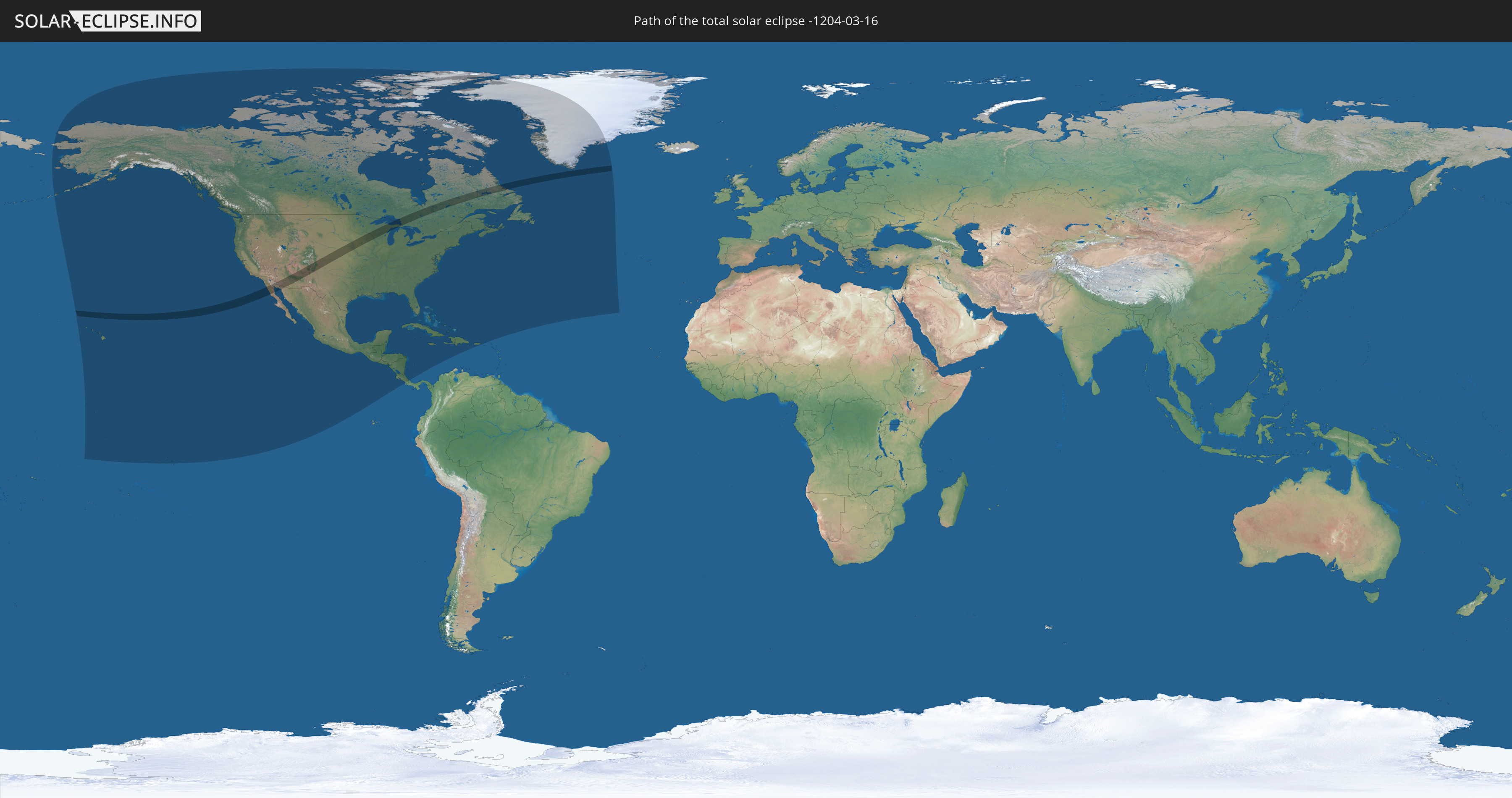
Die Sonnenfinsternis am 03/16/-1204 kann man in 28 Ländern als partielle Sonnenfinsternis beobachten.
Der Finsternispfad verläuft durch 3 Länder. Nur in diesen Ländern ist sie als total Sonnenfinsternis zu sehen.
In den folgenden Ländern ist die Sonnenfinsternis total zu sehen
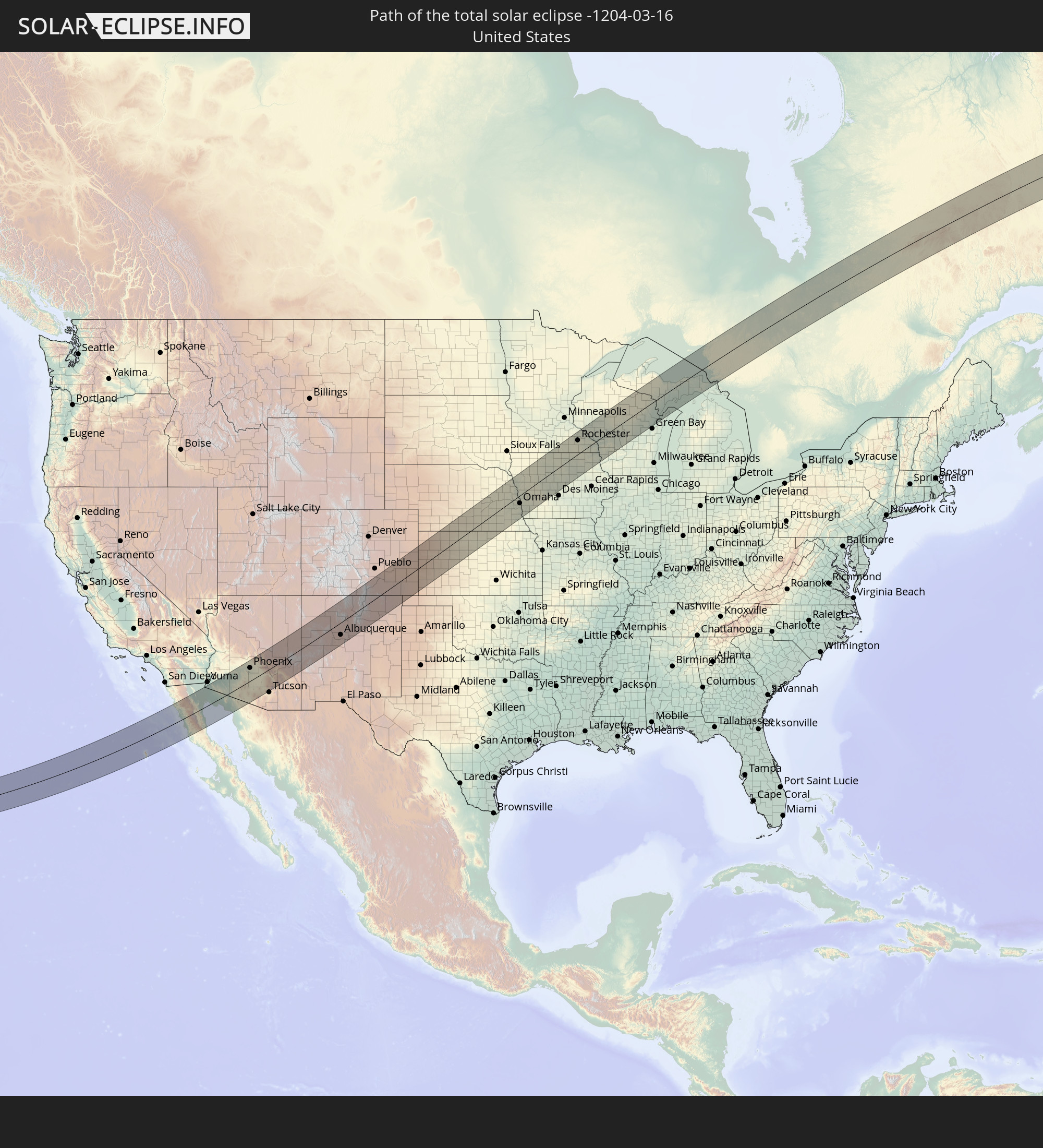 United States
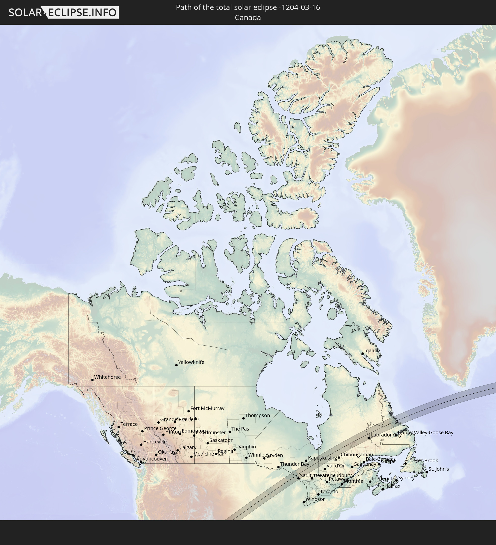 Canada
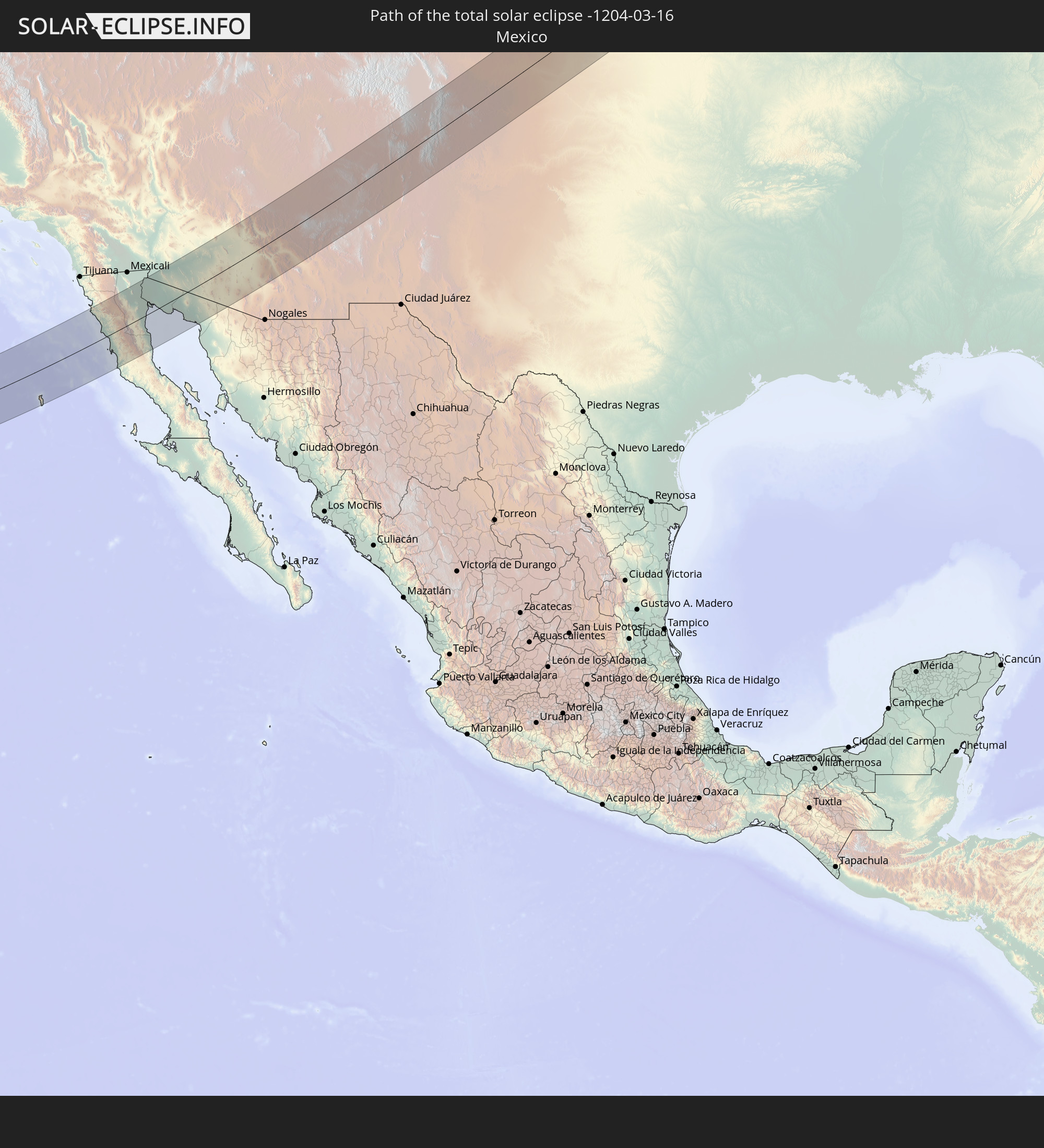 Mexico
In den folgenden Ländern ist die Sonnenfinsternis partiell zu sehen
 United States
 United States Minor Outlying Islands
 Kiribati
 Cook Islands
 French Polynesia
 Canada
 Mexico
 Greenland
 Guatemala
 El Salvador
 Honduras
 Belize
 Nicaragua
 Costa Rica
 Cuba
Cuba
 Panama
 Colombia
 Cayman Islands
 The Bahamas
 Jamaica
 Haiti
Haiti
 Turks and Caicos Islands
 Dominican Republic
 Puerto Rico
 United States Virgin Islands
 Bermuda
 British Virgin Islands
 Saint Pierre and Miquelon
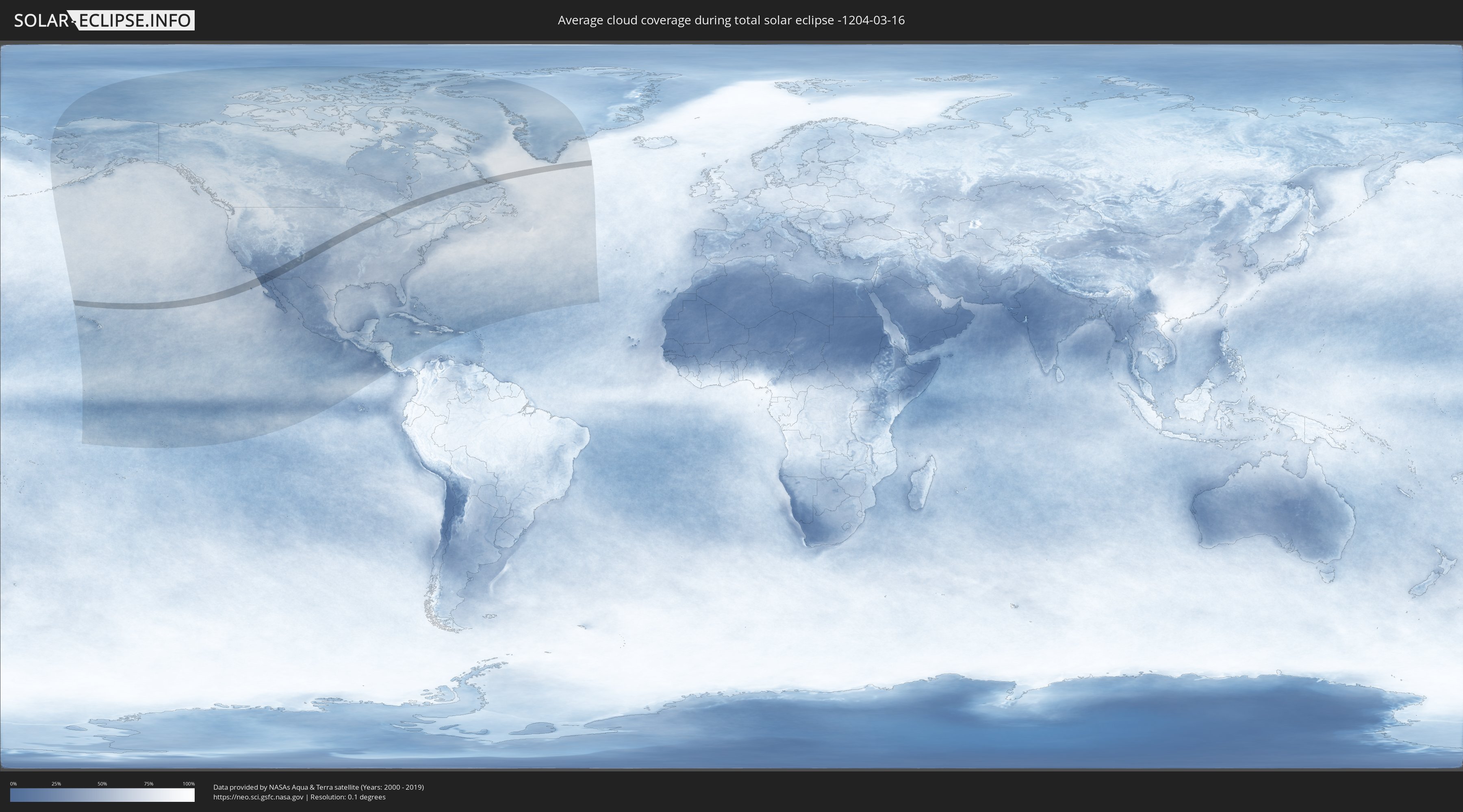
How will be the weather during the total solar eclipse on 03/16/-1204?
Where is the best place to see the total solar eclipse of 03/16/-1204?
The following maps show the average cloud coverage for the day of the total solar eclipse.
With the help of these maps, it is possible to find the place along the eclipse path, which has the best
chance of a cloudless sky.
Nevertheless, you should consider local circumstances and inform about the weather of your chosen
observation site.
The data is provided by NASAs satellites
AQUA and TERRA.
The cloud maps are averaged over a period of 19 years (2000 - 2019).

Detailed country maps
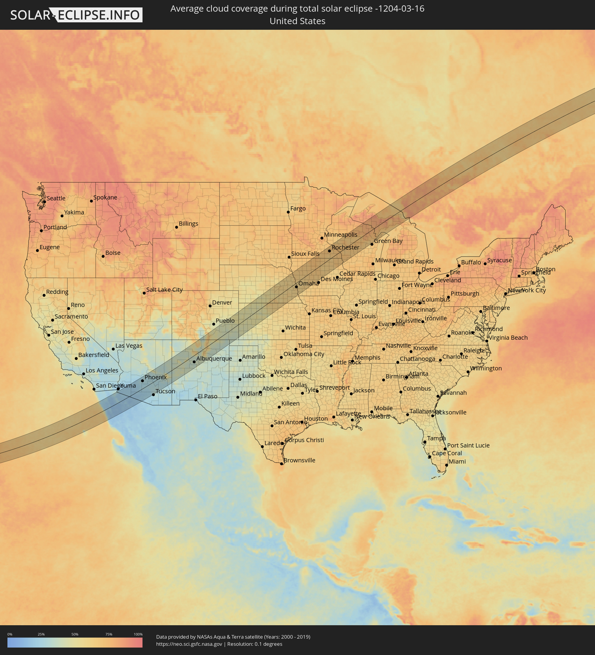 United States
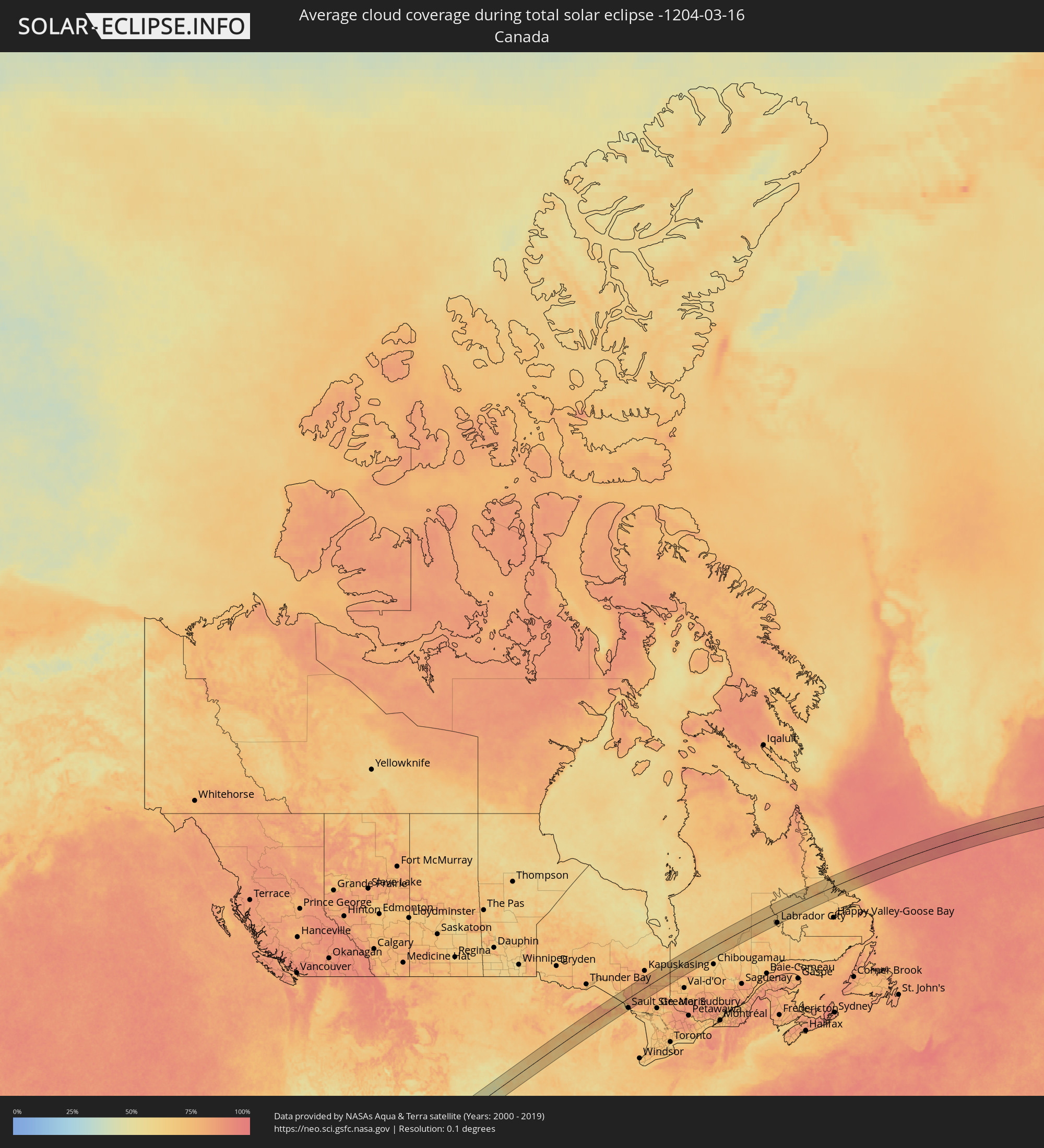 Canada
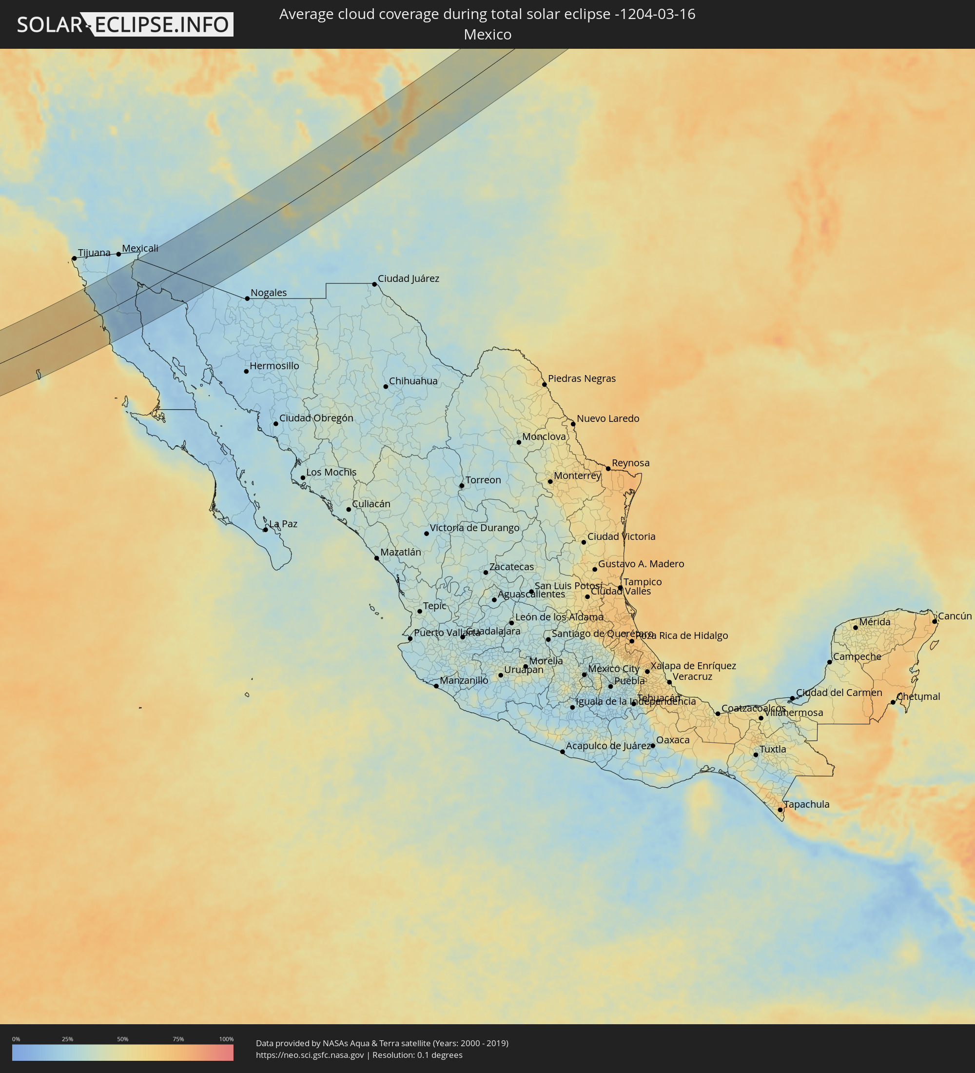 Mexico
Cities inside the path of the eclipse
The following table shows all locations with a population of more than 5,000 inside the eclipse path. Cities which have more than 100,000 inhabitants are marked bold. A click at the locations opens a detailed map.
| City | Type | Eclipse duration | Local time of max. eclipse | Distance to central line | Ø Cloud coverage |
|
Benito García (El Zorrillo), Baja California
|
total | - | 10:22:12 UTC-07:48 | 98 km | 28% |
|
Camalú, Baja California
|
total | - | 10:21:49 UTC-07:48 | 3 km | 45% |
|
Emiliano Zapata, Baja California
|
total | - | 10:21:48 UTC-07:48 | 15 km | 34% |
|
Vicente Guerrero, Baja California
|
total | - | 10:21:48 UTC-07:48 | 18 km | 41% |
|
San Quintín, Baja California
|
total | - | 10:21:38 UTC-07:48 | 36 km | 31% |
|
Doctor Alberto Oviedo Mota, Baja California
|
total | - | 10:25:39 UTC-07:48 | 92 km | 23% |
|
Guadalupe Victoria, Baja California
|
total | - | 10:25:52 UTC-07:48 | 95 km | 28% |
|
Ciudad Coahuila (Kilómetro Cincuenta y Siete), Baja California
|
total | - | 10:25:56 UTC-07:48 | 81 km | 25% |
|
Estación Coahuila, Baja California
|
total | - | 10:25:56 UTC-07:48 | 81 km | 25% |
|
San Felipe, Baja California
|
total | - | 10:24:31 UTC-07:48 | 41 km | 17% |
|
San Luis, Arizona
|
total | - | 10:51:00 UTC-07:23 | 99 km | 24% |
|
San Luis Río Colorado, Sonora
|
total | - | 10:50:58 UTC-07:23 | 96 km | 24% |
|
Fortuna Foothills, Arizona
|
total | - | 11:15:51 UTC-07:00 | 98 km | 21% |
|
Puerto Peñasco, Sonora
|
total | - | 10:51:46 UTC-07:23 | 72 km | 19% |
|
Sonoyta, Sonora
|
total | - | 10:53:57 UTC-07:23 | 52 km | 19% |
|
Buckeye, Arizona
|
total | - | 11:20:31 UTC-07:00 | 80 km | 25% |
|
Avondale, Arizona
|
total | - | 11:21:05 UTC-07:00 | 75 km | 27% |
|
Peoria, Arizona
|
total | - | 11:21:30 UTC-07:00 | 83 km | 27% |
|
Phoenix, Arizona
|
total | - | 11:21:39 UTC-07:00 | 62 km | 26% |
|
Maricopa, Arizona
|
total | - | 11:21:09 UTC-07:00 | 24 km | 26% |
|
Paradise Valley, Arizona
|
total | - | 11:22:02 UTC-07:00 | 64 km | 27% |
|
Sun Lakes, Arizona
|
total | - | 11:21:43 UTC-07:00 | 30 km | 25% |
|
Mesa, Arizona
|
total | - | 11:22:05 UTC-07:00 | 47 km | 26% |
|
Casa Grande, Arizona
|
total | - | 11:21:29 UTC-07:00 | 7 km | 27% |
|
Fountain Hills, Arizona
|
total | - | 11:22:36 UTC-07:00 | 61 km | 27% |
|
Eloy, Arizona
|
total | - | 11:21:44 UTC-07:00 | 29 km | 24% |
|
Apache Junction, Arizona
|
total | - | 11:22:40 UTC-07:00 | 34 km | 25% |
|
San Tan Valley, Arizona
|
total | - | 11:22:23 UTC-07:00 | 11 km | 27% |
|
Florence, Arizona
|
total | - | 11:22:27 UTC-07:00 | 11 km | 27% |
|
Payson, Arizona
|
total | - | 11:24:14 UTC-07:00 | 100 km | 31% |
|
Gold Camp, Arizona
|
total | - | 11:22:59 UTC-07:00 | 10 km | 26% |
|
Marana, Arizona
|
total | - | 11:21:57 UTC-07:00 | 75 km | 23% |
|
Casas Adobes, Arizona
|
total | - | 11:22:16 UTC-07:00 | 97 km | 26% |
|
Show Low, Arizona
|
total | - | 11:26:53 UTC-07:00 | 38 km | 33% |
|
Gallup, New Mexico
|
total | - | 11:31:08 UTC-07:00 | 92 km | 38% |
|
Grants, New Mexico
|
total | - | 11:32:27 UTC-07:00 | 12 km | 39% |
|
Los Lunas, New Mexico
|
total | - | 11:34:18 UTC-07:00 | 76 km | 34% |
|
Rio Rancho, New Mexico
|
total | - | 11:34:58 UTC-07:00 | 40 km | 35% |
|
Albuquerque, New Mexico
|
total | - | 11:34:49 UTC-07:00 | 55 km | 34% |
|
Los Alamos, New Mexico
|
total | - | 11:36:29 UTC-07:00 | 2 km | 43% |
|
Española, New Mexico
|
total | - | 11:37:03 UTC-07:00 | 0 km | 39% |
|
Santa Fe, New Mexico
|
total | - | 11:36:59 UTC-07:00 | 35 km | 44% |
|
Las Vegas, New Mexico
|
total | - | 11:38:19 UTC-07:00 | 80 km | 39% |
|
Garden City, Kansas
|
total | - | 12:49:31 UTC-06:00 | 84 km | 46% |
|
Hays, Kansas
|
total | - | 12:53:19 UTC-06:00 | 80 km | 53% |
|
Kearney, Nebraska
|
total | - | 12:55:16 UTC-06:00 | 73 km | 55% |
|
Hastings, Nebraska
|
total | - | 12:56:28 UTC-06:00 | 28 km | 54% |
|
Grand Island, Nebraska
|
total | - | 12:56:48 UTC-06:00 | 56 km | 55% |
|
Columbus, Nebraska
|
total | - | 12:58:56 UTC-06:00 | 54 km | 61% |
|
Beatrice, Nebraska
|
total | - | 12:59:15 UTC-06:00 | 82 km | 63% |
|
Lincoln, Nebraska
|
total | - | 12:59:46 UTC-06:00 | 37 km | 64% |
|
Fremont, Nebraska
|
total | - | 13:00:30 UTC-06:00 | 12 km | 62% |
|
Chalco, Nebraska
|
total | - | 13:00:58 UTC-06:00 | 28 km | 62% |
|
Omaha, Nebraska
|
total | - | 13:01:23 UTC-06:00 | 32 km | 63% |
|
Storm Lake, Iowa
|
total | - | 13:03:31 UTC-06:00 | 58 km | 66% |
|
Carroll, Iowa
|
total | - | 13:03:47 UTC-06:00 | 10 km | 65% |
|
Fort Dodge, Iowa
|
total | - | 13:05:14 UTC-06:00 | 4 km | 68% |
|
Boone, Iowa
|
total | - | 13:05:30 UTC-06:00 | 58 km | 63% |
|
Ames, Iowa
|
total | - | 13:05:56 UTC-06:00 | 72 km | 65% |
|
Albert Lea, Minnesota
|
total | - | 13:07:10 UTC-06:00 | 62 km | 69% |
|
Mason City, Iowa
|
total | - | 13:07:13 UTC-06:00 | 10 km | 67% |
|
Austin, Minnesota
|
total | - | 13:07:49 UTC-06:00 | 46 km | 70% |
|
Waverly, Iowa
|
total | - | 13:08:14 UTC-06:00 | 63 km | 64% |
|
Rochester, Minnesota
|
total | - | 13:08:49 UTC-06:00 | 54 km | 71% |
|
Cedar Falls, Iowa
|
total | - | 13:08:12 UTC-06:00 | 83 km | 65% |
|
Winona, Minnesota
|
total | - | 13:10:11 UTC-06:00 | 19 km | 72% |
|
Eau Claire, Wisconsin
|
total | - | 13:10:41 UTC-06:00 | 82 km | 67% |
|
Chippewa Falls, Wisconsin
|
total | - | 13:10:54 UTC-06:00 | 88 km | 67% |
|
La Crosse, Wisconsin
|
total | - | 13:10:45 UTC-06:00 | 22 km | 74% |
|
Sparta, Wisconsin
|
total | - | 13:11:29 UTC-06:00 | 29 km | 69% |
|
Marshfield, Wisconsin
|
total | - | 13:12:45 UTC-06:00 | 8 km | 68% |
|
Wisconsin Rapids, Wisconsin
|
total | - | 13:13:14 UTC-06:00 | 34 km | 72% |
|
Merrill, Wisconsin
|
total | - | 13:13:40 UTC-06:00 | 33 km | 68% |
|
Wausau, Wisconsin
|
total | - | 13:13:41 UTC-06:00 | 11 km | 72% |
|
Stevens Point, Wisconsin
|
total | - | 13:13:39 UTC-06:00 | 32 km | 67% |
|
Shawano, Wisconsin
|
total | - | 13:15:14 UTC-06:00 | 51 km | 65% |
|
Marinette, Wisconsin
|
total | - | 13:16:49 UTC-06:00 | 65 km | 69% |
|
Marquette, Michigan
|
total | - | 14:17:24 UTC-05:00 | 58 km | 83% |
|
Escanaba, Michigan
|
total | - | 14:17:46 UTC-05:00 | 30 km | 69% |
|
Sault Ste. Marie, Michigan
|
total | - | 14:21:47 UTC-05:00 | 75 km | 64% |
|
Sault Ste. Marie, Ontario
|
total | - | 14:21:48 UTC-05:00 | 73 km | 64% |
|
Timmins, Ontario
|
total | - | 14:25:43 UTC-05:00 | 11 km | 76% |
|
La Sarre, Quebec
|
total | - | 14:28:20 UTC-05:00 | 61 km | 65% |
|
Labrador City, Newfoundland and Labrador
|
total | - | 15:24:44 UTC-04:14 | 70 km | 66% |