Annular solar eclipse of 12/10/-1302
| Day of week: | Thursday |
| Maximum duration of eclipse: | 07m21s |
| Maximum width of eclipse path: | 337 km |
| Saros cycle: | 21 |
| Coverage: | 92.5% |
| Magnitude: | 0.9251 |
| Gamma: | -0.5439 |
Wo kann man die Sonnenfinsternis vom 12/10/-1302 sehen?
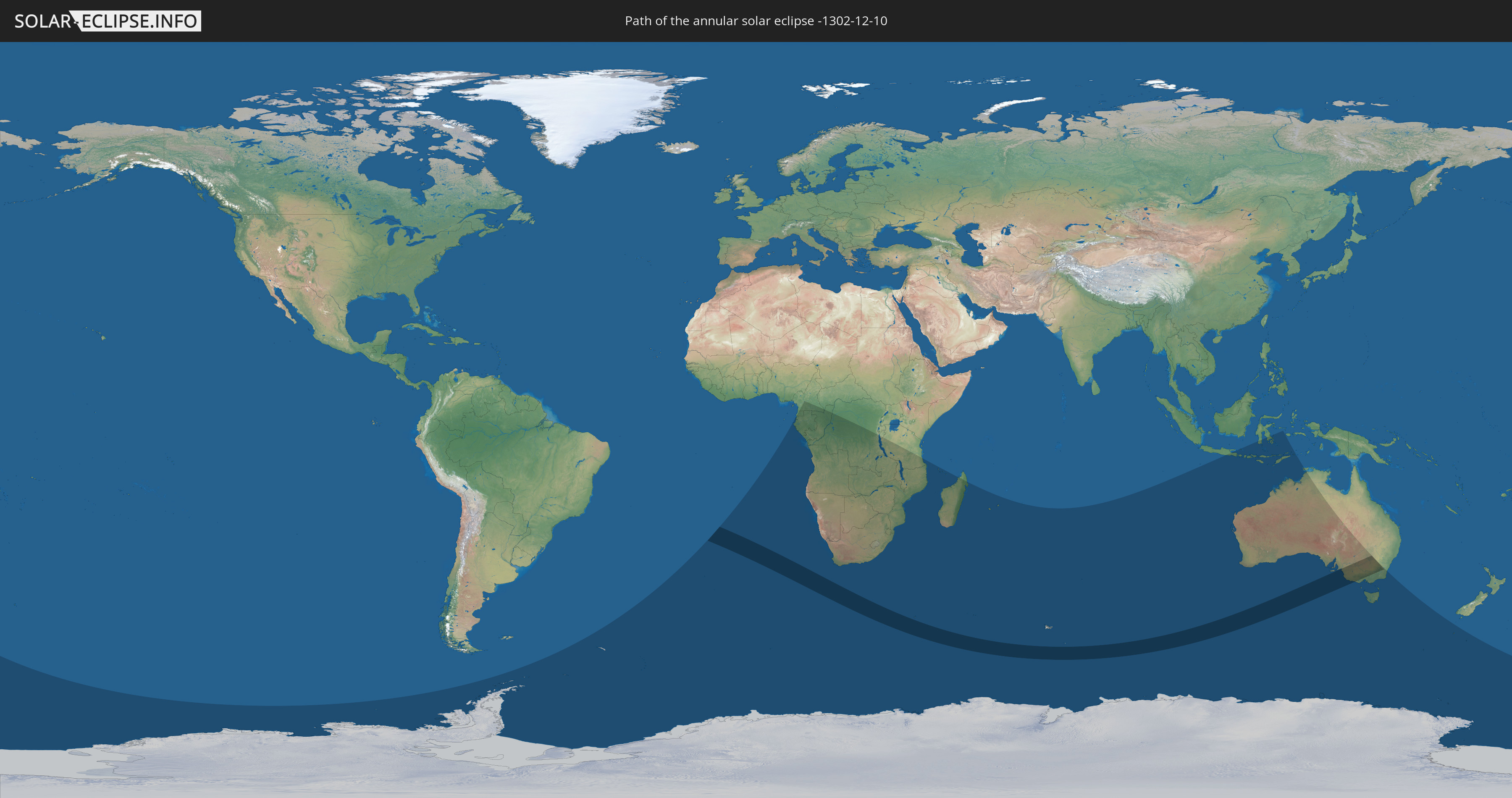
Die Sonnenfinsternis am 12/10/-1302 kann man in 33 Ländern als partielle Sonnenfinsternis beobachten.
Der Finsternispfad verläuft durch ein Land. Nur in diesem Land ist sie als annular Sonnenfinsternis zu sehen.
In den folgenden Ländern ist die Sonnenfinsternis annular zu sehen
 Australia
In den folgenden Ländern ist die Sonnenfinsternis partiell zu sehen
 Antarctica
 New Zealand
 South Georgia and the South Sandwich Islands
 Saint Helena, Ascension and Tristan da Cunha
 Bouvet Island
 Equatorial Guinea
 Cameroon
 Gabon
Gabon
 Republic of the Congo
 Angola
 Namibia
 Democratic Republic of the Congo
 Central African Republic
 South Africa
 Botswana
 Zambia
 Zimbabwe
 Lesotho
 Burundi
 Tanzania
 Mozambique
 Swaziland
 Malawi
 French Southern and Antarctic Lands
 Madagascar
 Comoros
 Mayotte
 Réunion
 Mauritius
 Heard Island and McDonald Islands
 Indonesia
 Australia
 East Timor
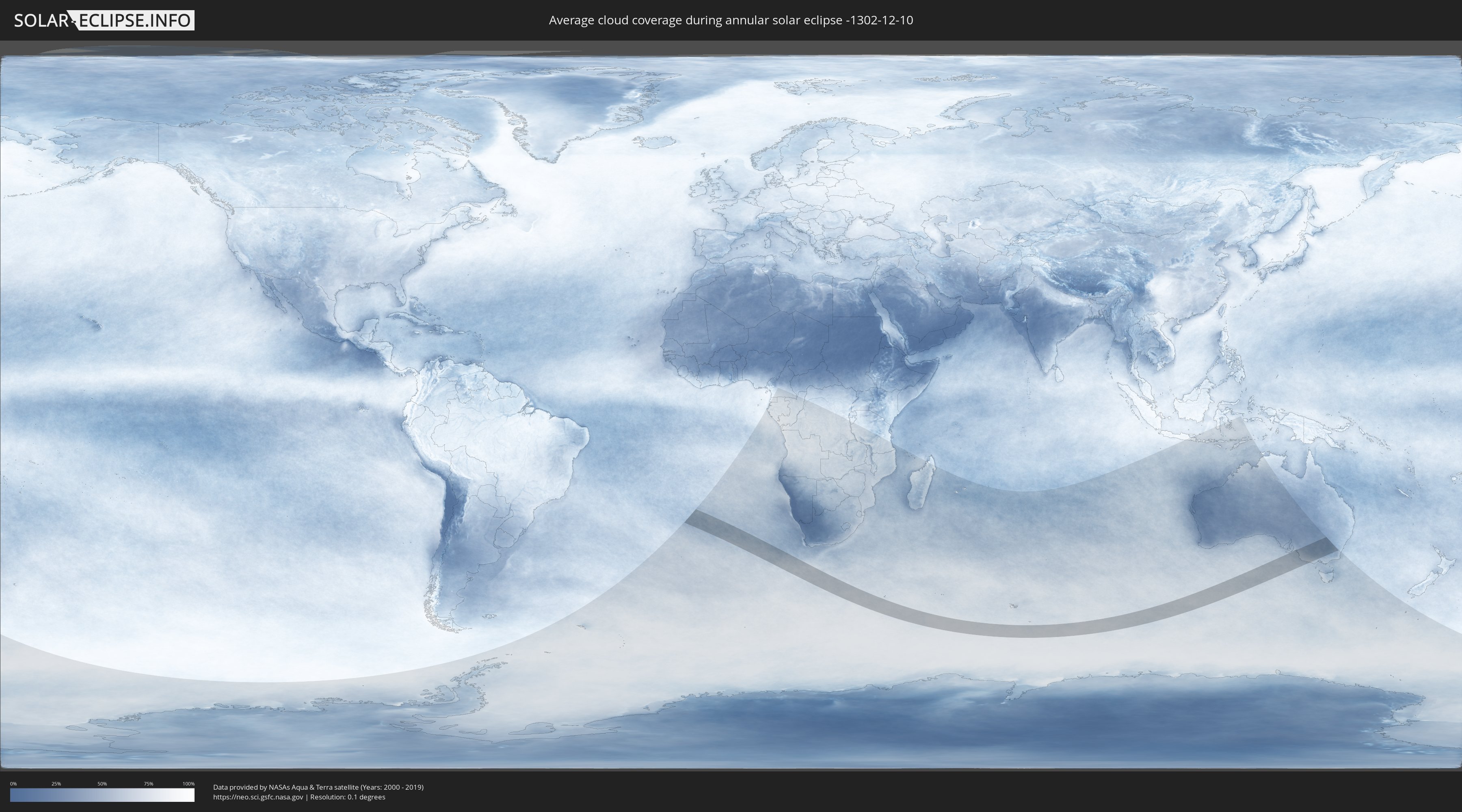
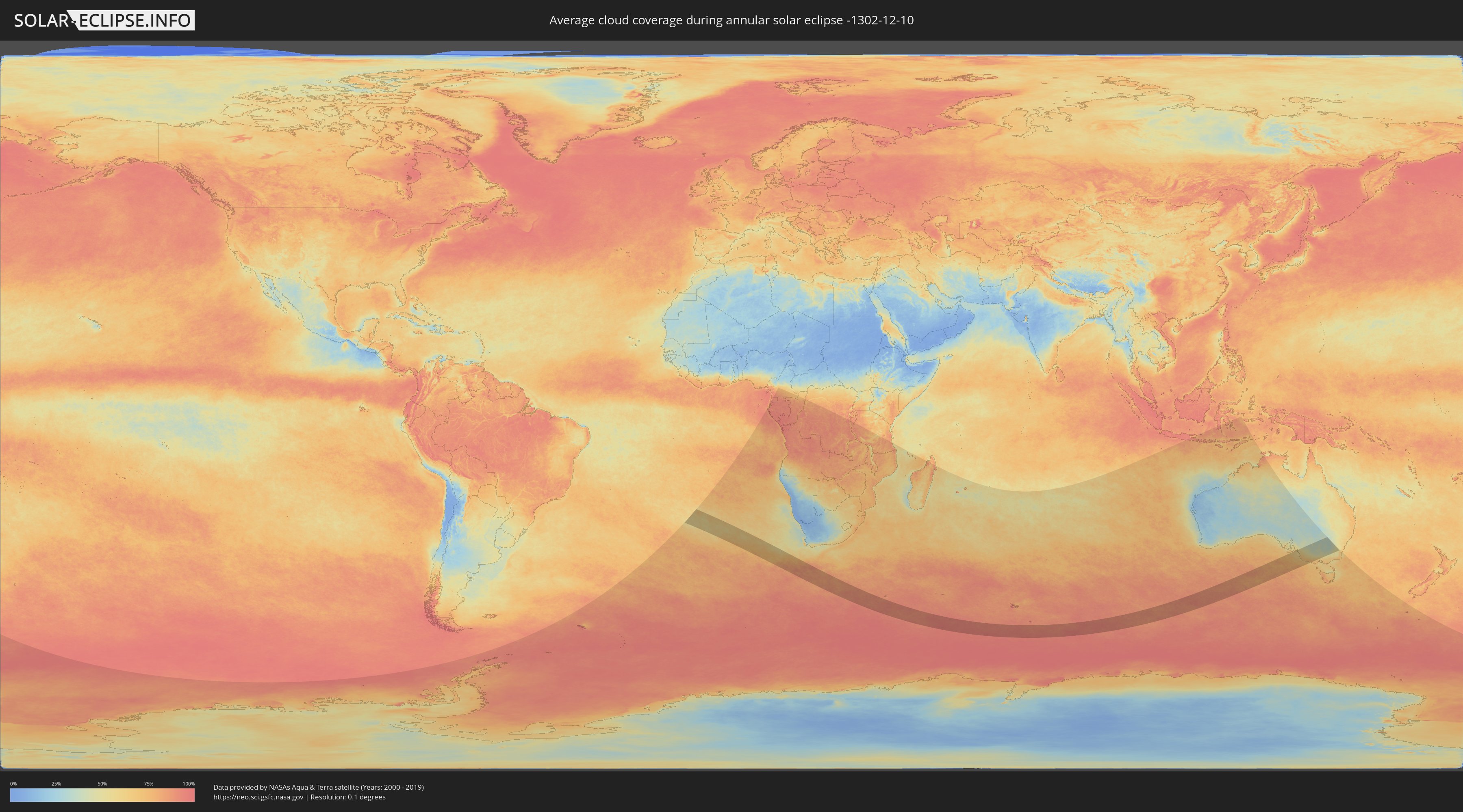
How will be the weather during the annular solar eclipse on 12/10/-1302?
Where is the best place to see the annular solar eclipse of 12/10/-1302?
The following maps show the average cloud coverage for the day of the annular solar eclipse.
With the help of these maps, it is possible to find the place along the eclipse path, which has the best
chance of a cloudless sky.
Nevertheless, you should consider local circumstances and inform about the weather of your chosen
observation site.
The data is provided by NASAs satellites
AQUA and TERRA.
The cloud maps are averaged over a period of 19 years (2000 - 2019).
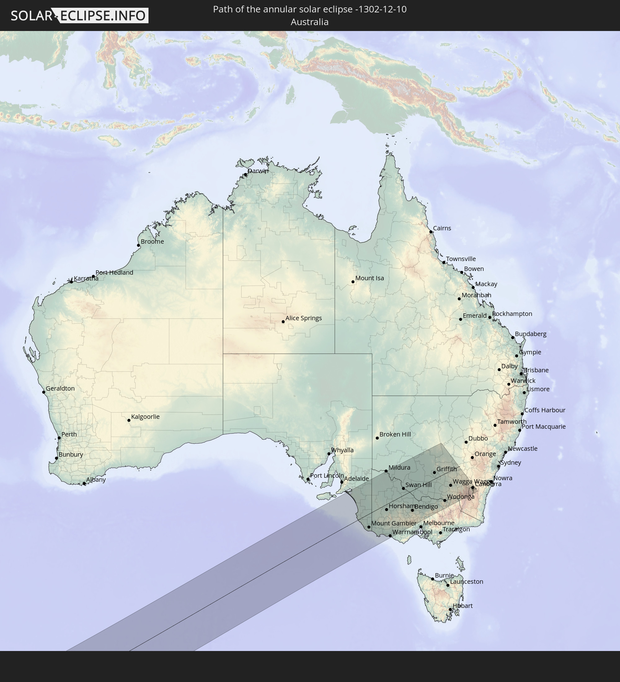
Detailed country maps
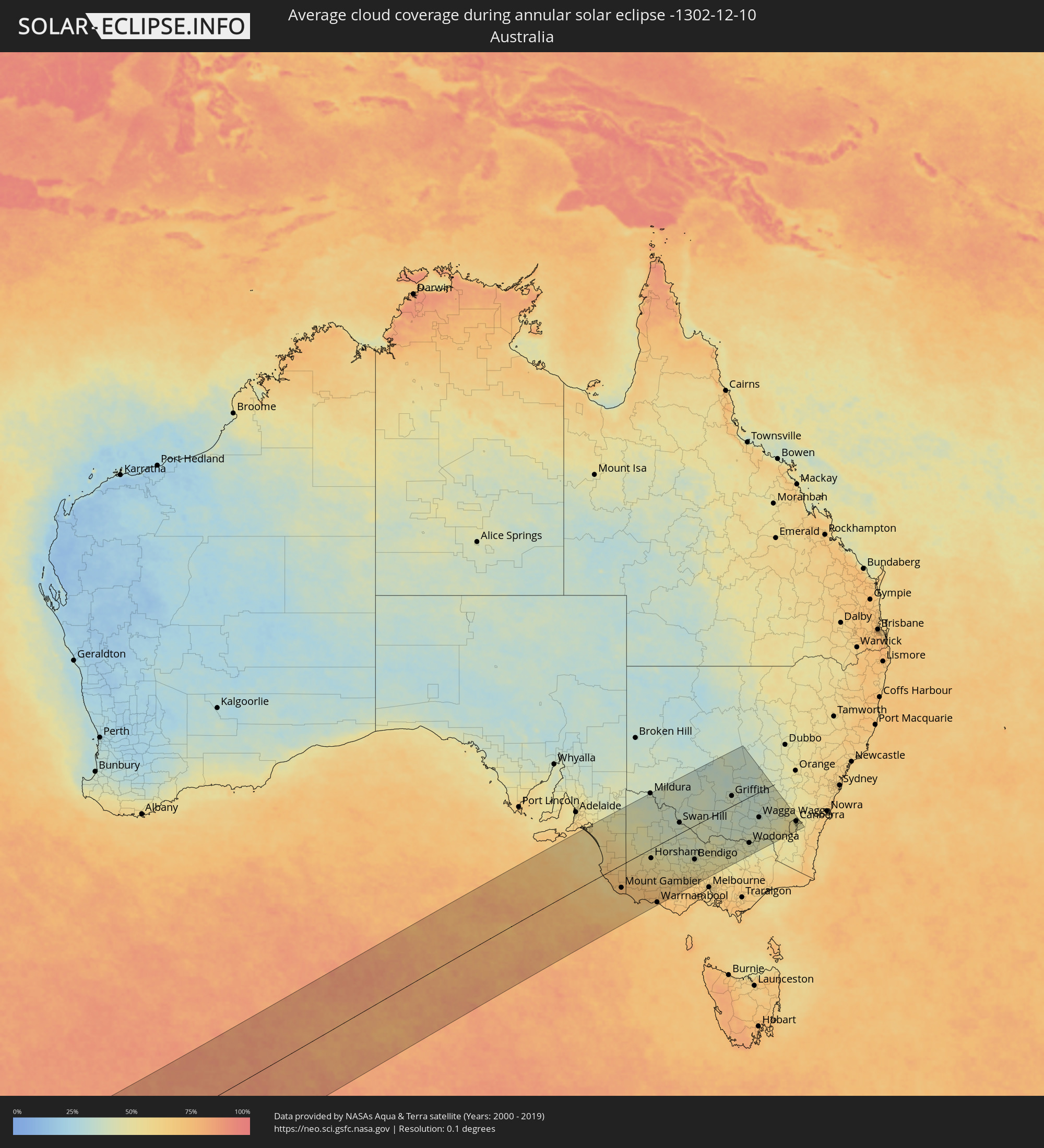 Australia
Cities inside the path of the eclipse
The following table shows all locations with a population of more than 5,000 inside the eclipse path. Cities which have more than 100,000 inhabitants are marked bold. A click at the locations opens a detailed map.
| City | Type | Eclipse duration | Local time of max. eclipse | Distance to central line | Ø Cloud coverage |
|
Millicent, South Australia
|
annular | - | 18:35:16 UTC+09:30 | 45 km | 69% |
|
Naracoorte, South Australia
|
annular | - | 18:35:58 UTC+09:30 | 25 km | 66% |
|
Mount Gambier, South Australia
|
annular | - | 18:34:51 UTC+09:30 | 87 km | 75% |
|
Portland, Victoria
|
annular | - | 19:03:59 UTC+10:00 | 171 km | 69% |
|
Hamilton, Victoria
|
annular | - | 19:04:38 UTC+10:00 | 130 km | 69% |
|
Mildura, Victoria
|
annular | - | 19:08:55 UTC+10:00 | 216 km | 40% |
|
Horsham, Victoria
|
annular | - | 19:05:52 UTC+10:00 | 36 km | 54% |
|
Warrnambool, Victoria
|
annular | - | 19:03:41 UTC+10:00 | 212 km | 66% |
|
Stawell, Victoria
|
annular | - | 19:05:16 UTC+10:00 | 97 km | 52% |
|
Ararat, Victoria
|
annular | - | 19:04:56 UTC+10:00 | 125 km | 56% |
|
Swan Hill, Victoria
|
annular | - | 19:07:05 UTC+10:00 | 48 km | 39% |
|
Maryborough, Victoria
|
annular | - | 19:04:58 UTC+10:00 | 134 km | 50% |
|
Sebastopol, Victoria
|
annular | - | 19:04:17 UTC+10:00 | 192 km | 66% |
|
Ballarat, Victoria
|
annular | - | 19:04:18 UTC+10:00 | 190 km | 66% |
|
Ballarat Central, Victoria
|
annular | - | 19:04:18 UTC+10:00 | 190 km | 65% |
|
Castlemaine, Victoria
|
annular | - | 19:04:47 UTC+10:00 | 157 km | 53% |
|
Kangaroo Flat, Victoria
|
annular | - | 19:05:06 UTC+10:00 | 132 km | 48% |
|
Golden Square, Victoria
|
annular | - | 19:05:08 UTC+10:00 | 129 km | 48% |
|
Bendigo, Victoria
|
annular | - | 19:05:08 UTC+10:00 | 129 km | 48% |
|
Kennington, Victoria
|
annular | - | 19:05:06 UTC+10:00 | 133 km | 48% |
|
Echuca, Victoria
|
annular | - | 19:05:43 UTC+10:00 | 91 km | 45% |
|
Deniliquin, New South Wales
|
annular | - | 19:06:21 UTC+10:00 | 44 km | 40% |
|
Kyabram, Victoria
|
annular | - | 19:05:24 UTC+10:00 | 118 km | 47% |
|
Shepparton, Victoria
|
annular | - | 19:05:12 UTC+10:00 | 140 km | 47% |
|
Benalla, Victoria
|
annular | - | 19:04:46 UTC+10:00 | 181 km | 46% |
|
Yarrawonga, Victoria
|
annular | - | 19:05:23 UTC+10:00 | 130 km | 41% |
|
Griffith, New South Wales
|
annular | - | 19:07:21 UTC+10:00 | 47 km | 39% |
|
Wangaratta, Victoria
|
annular | - | 19:04:52 UTC+10:00 | 176 km | 46% |
|
Corowa, New South Wales
|
annular | - | 19:05:16 UTC+10:00 | 144 km | 44% |
|
Leeton, New South Wales
|
annular | - | 19:06:55 UTC+10:00 | 11 km | 39% |
|
Wodonga, Victoria
|
annular | - | 19:04:55 UTC+10:00 | 177 km | 44% |
|
Albury, New South Wales
|
annular | - | 19:04:58 UTC+10:00 | 174 km | 44% |
|
East Albury, New South Wales
|
annular | - | 19:04:57 UTC+10:00 | 174 km | 44% |
|
North Albury, New South Wales
|
annular | - | 19:04:59 UTC+10:00 | 172 km | 44% |
|
Lavington, New South Wales
|
annular | - | 19:05:00 UTC+10:00 | 171 km | 43% |
|
Wagga Wagga, New South Wales
|
annular | - | 19:05:52 UTC+10:00 | 99 km | 38% |
|
Lake Albert, New South Wales
|
annular | - | 19:05:48 UTC+10:00 | 104 km | 41% |
|
Tumut, New South Wales
|
annular | - | 19:05:17 UTC+10:00 | 152 km | 44% |
|
Young, New South Wales
|
annular | - | 19:06:21 UTC+10:00 | 57 km | 45% |
|
Kaleen, Australian Capital Territory
|
annular | - | 19:04:59 UTC+10:00 | 181 km | 50% |
|
Canberra, Australian Capital Territory
|
annular | - | 19:04:54 UTC+10:00 | 188 km | 49% |
|
Queanbeyan, New South Wales
|
annular | - | 19:04:47 UTC+10:00 | 200 km | 49% |