Total solar eclipse of 06/05/-1301
| Day of week: | Saturday |
| Maximum duration of eclipse: | 06m25s |
| Maximum width of eclipse path: | 272 km |
| Saros cycle: | 26 |
| Coverage: | 100% |
| Magnitude: | 1.0805 |
| Gamma: | 0.2982 |
Wo kann man die Sonnenfinsternis vom 06/05/-1301 sehen?
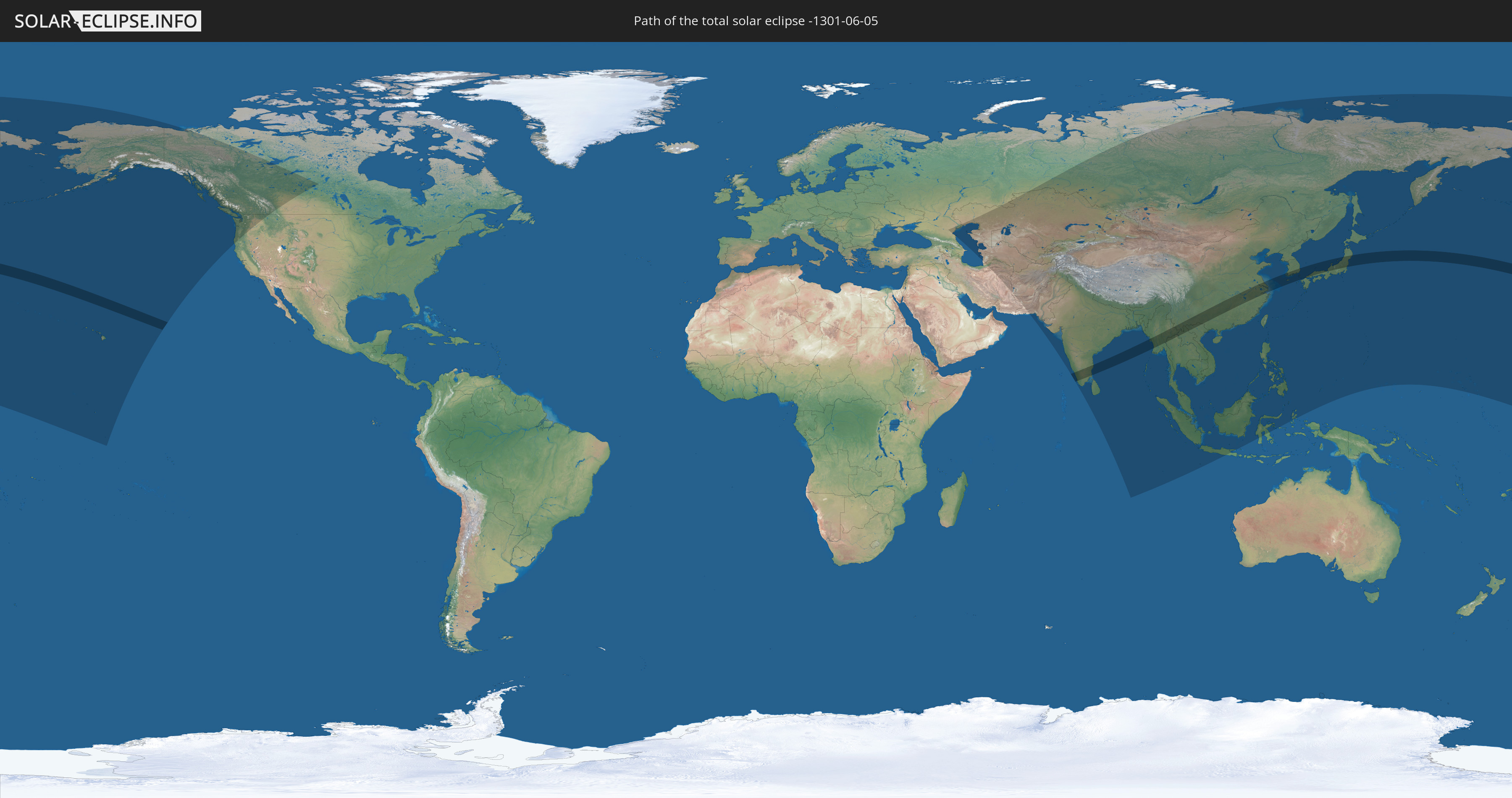
Die Sonnenfinsternis am 06/05/-1301 kann man in 43 Ländern als partielle Sonnenfinsternis beobachten.
Der Finsternispfad verläuft durch 8 Länder. Nur in diesen Ländern ist sie als total Sonnenfinsternis zu sehen.
In den folgenden Ländern ist die Sonnenfinsternis total zu sehen
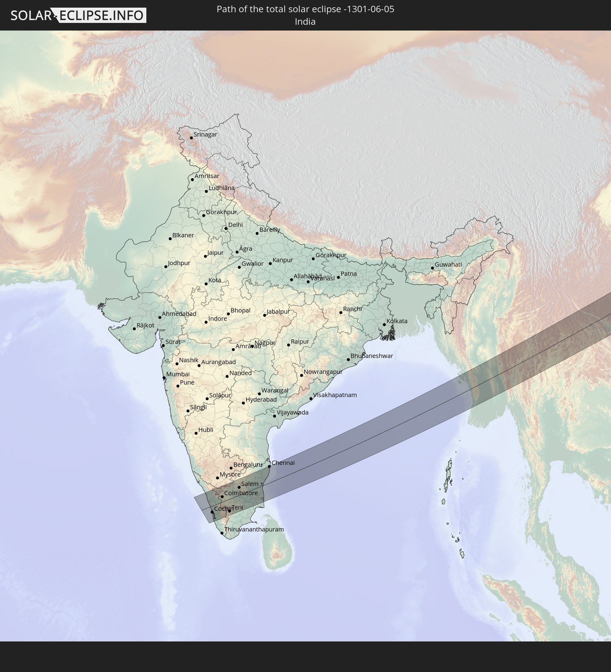 India
India
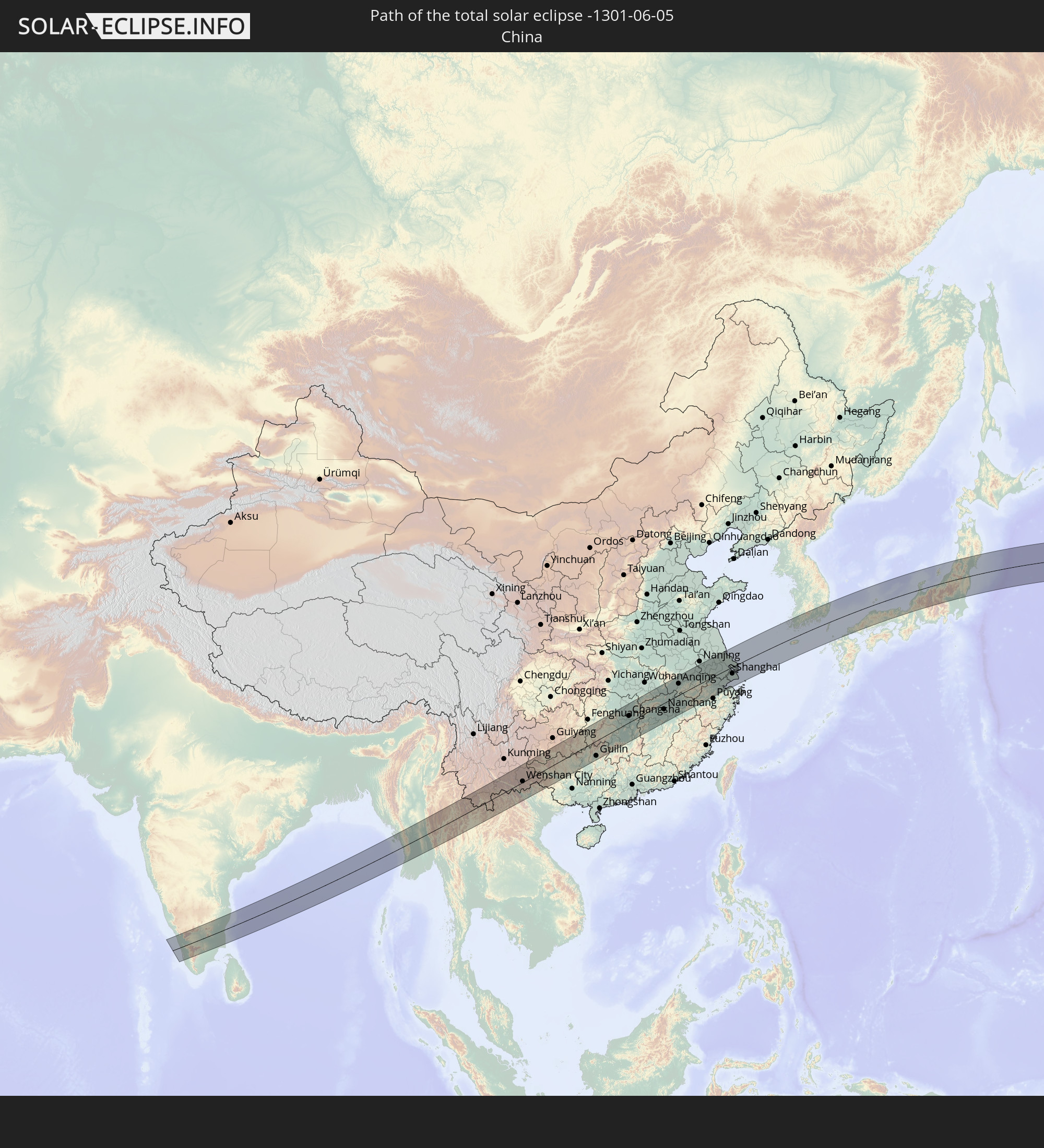 China
China
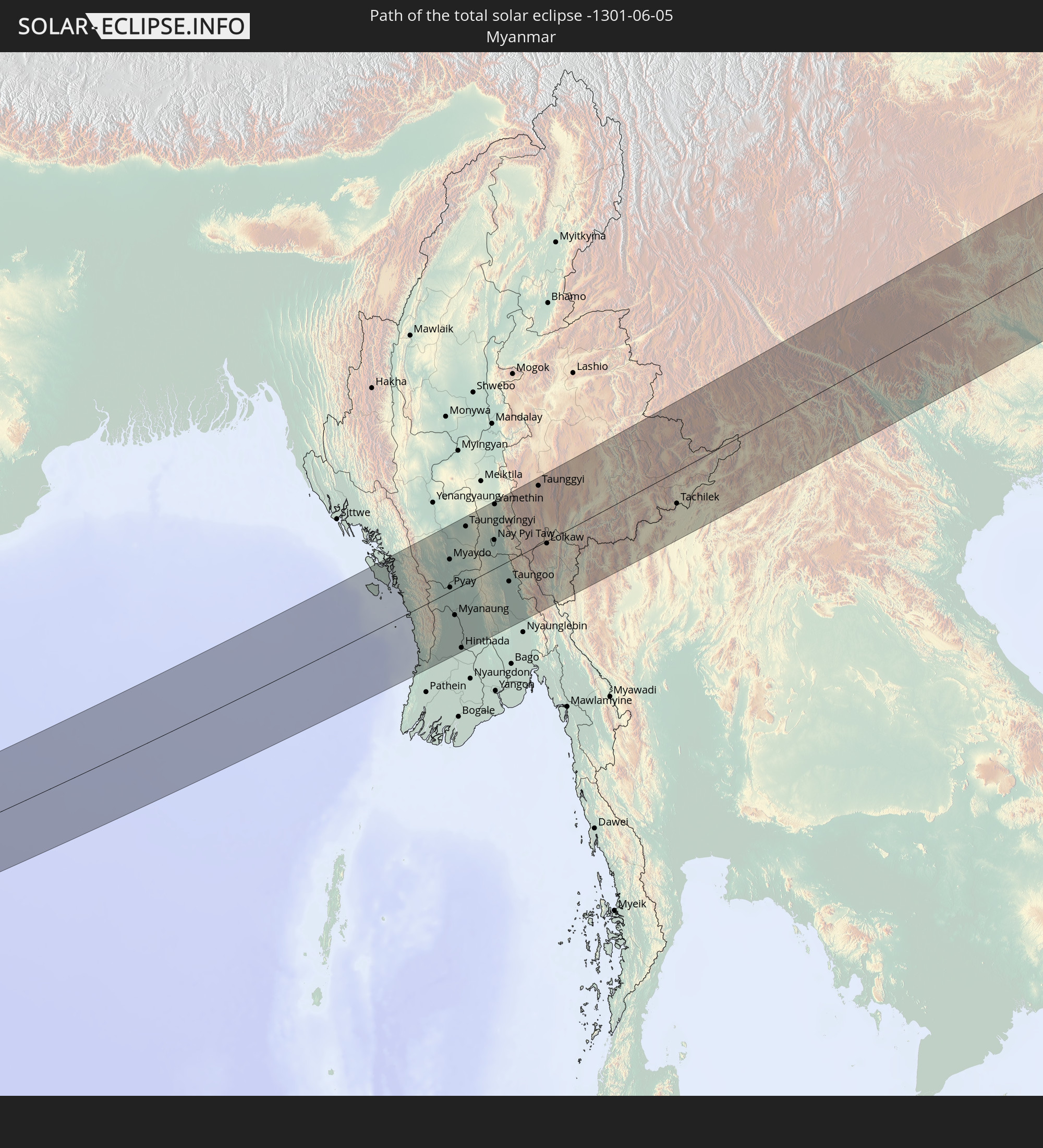 Myanmar
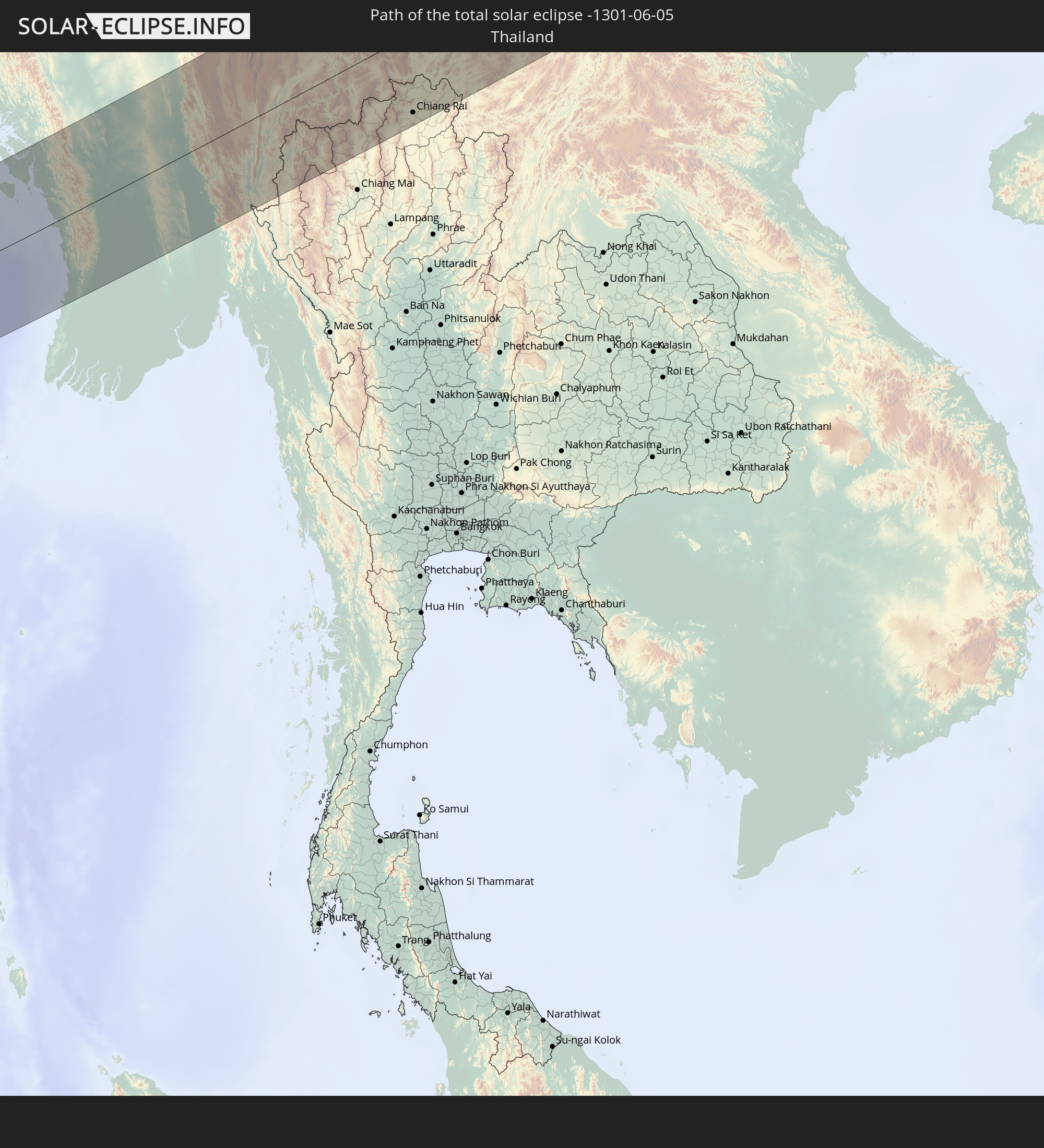 Thailand
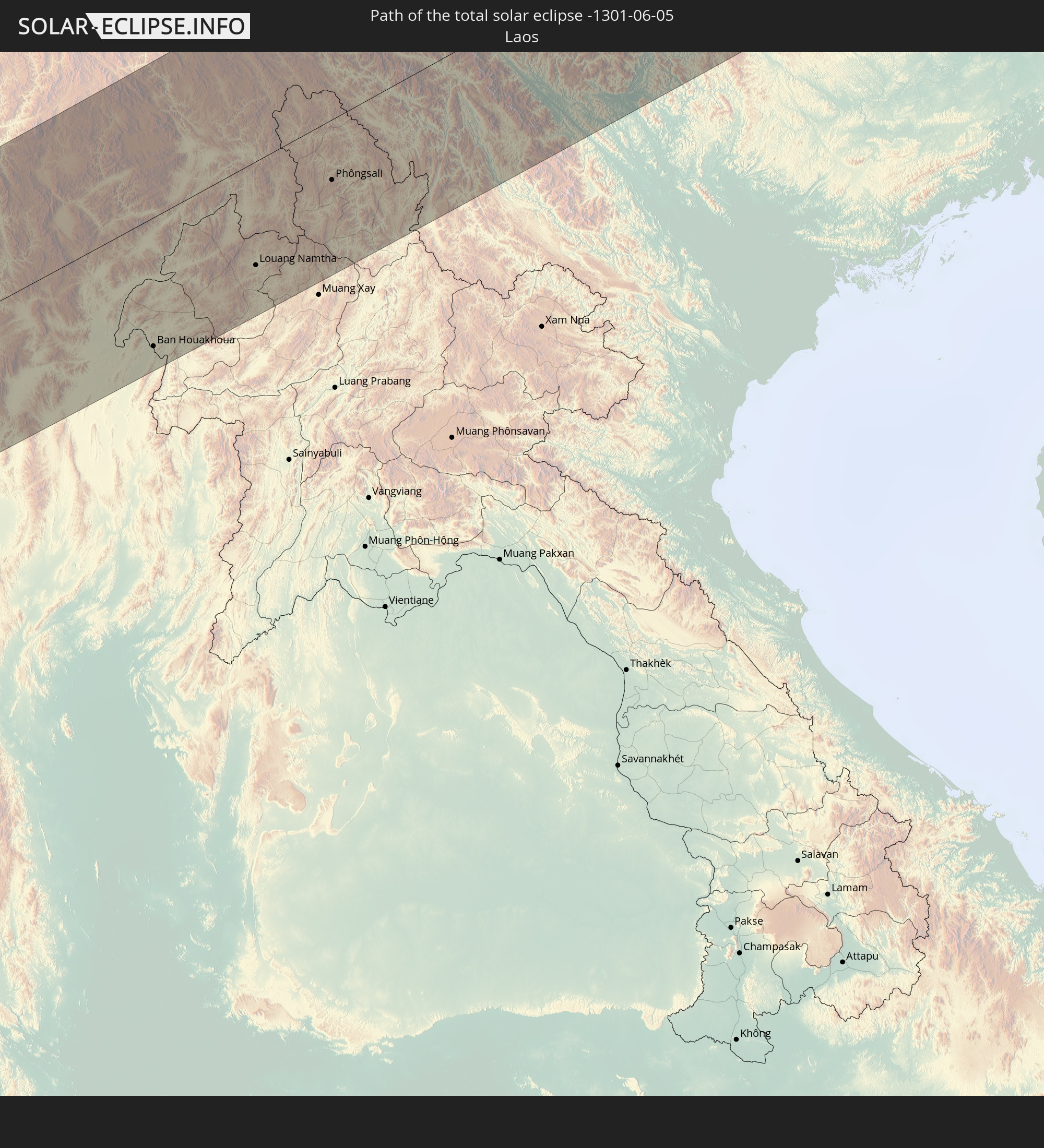 Laos
Laos
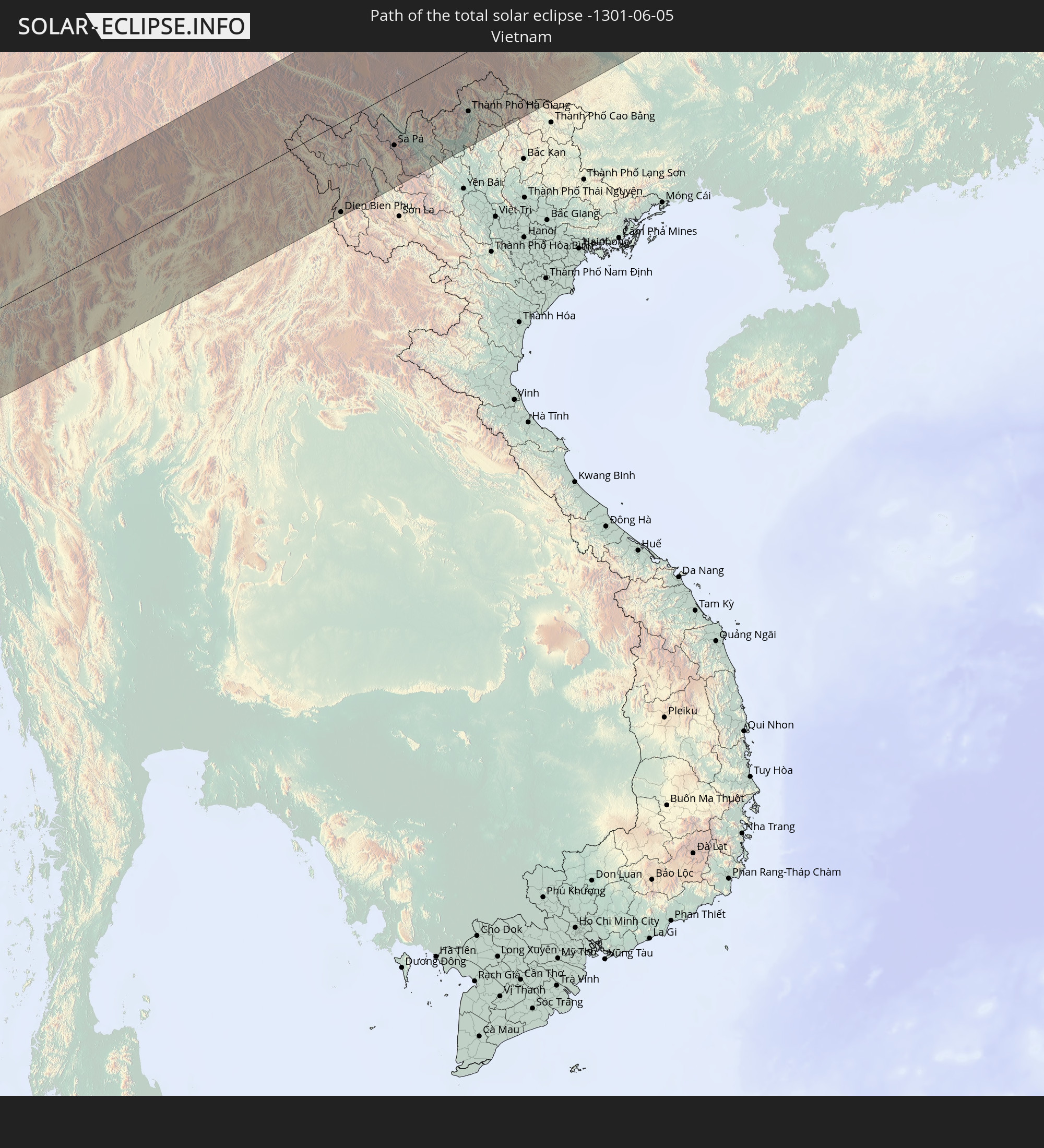 Vietnam
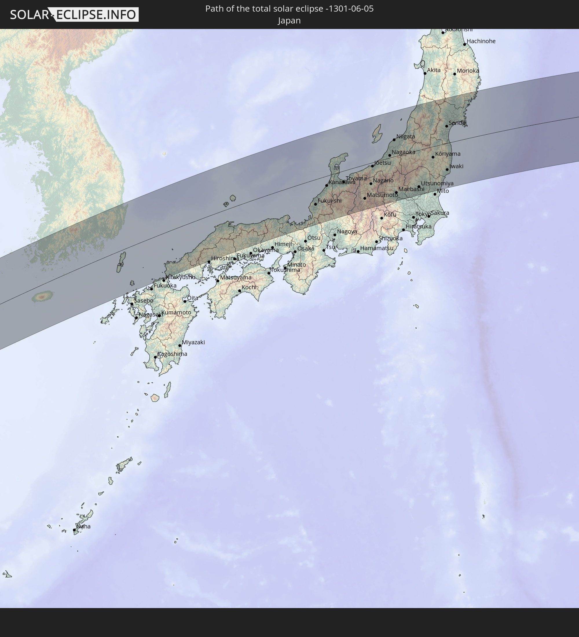 Japan
Japan
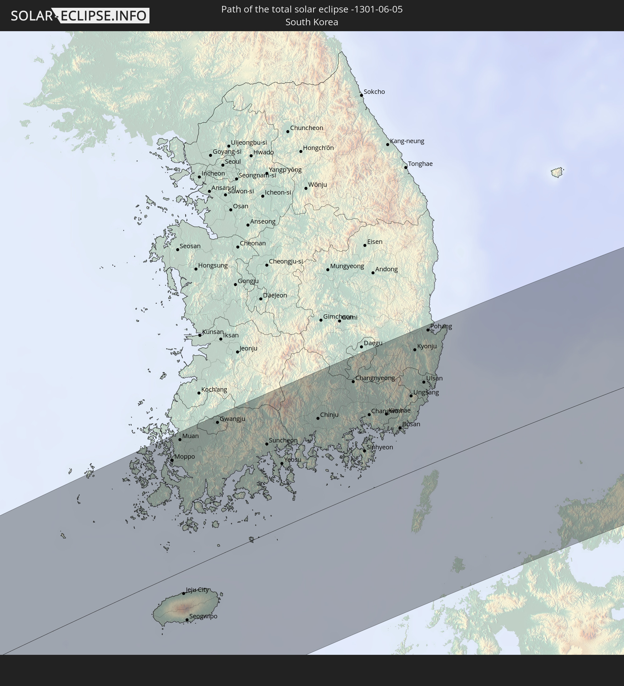 South Korea
In den folgenden Ländern ist die Sonnenfinsternis partiell zu sehen
 Russia
 United States
 United States Minor Outlying Islands
 Kiribati
 Canada
 Iran
Iran
 Kazakhstan
 Turkmenistan
 Uzbekistan
 Afghanistan
 Pakistan
 Tajikistan
 India
India
 Kyrgyzstan
 China
China
 Sri Lanka
 Nepal
Nepal
 Mongolia
 Bangladesh
 Bhutan
 Myanmar
 Indonesia
 Cocos Islands
 Thailand
 Malaysia
 Laos
Laos
 Vietnam
 Cambodia
 Singapore
 Christmas Island
 Macau
Macau
 Hong Kong
 Brunei
 Taiwan
 Philippines
 Japan
Japan
 North Korea
 South Korea
 Palau
Palau
 Federated States of Micronesia
 Guam
Guam
 Northern Mariana Islands
 Marshall Islands
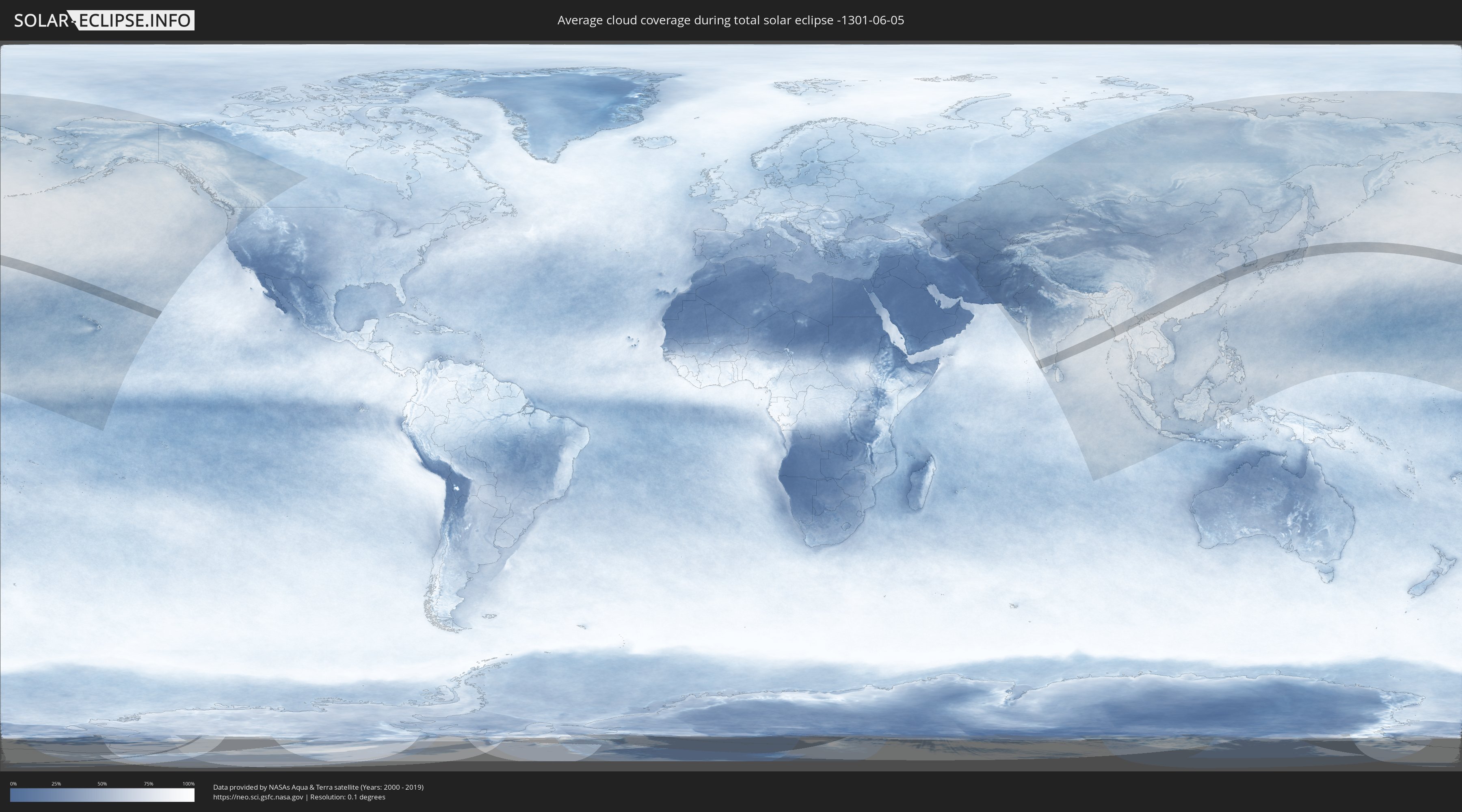
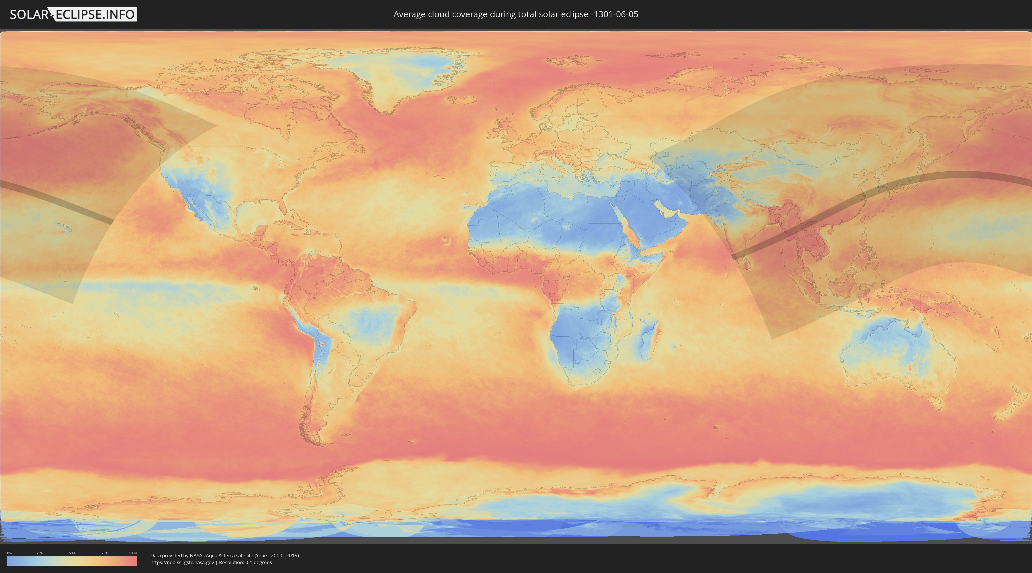
How will be the weather during the total solar eclipse on 06/05/-1301?
Where is the best place to see the total solar eclipse of 06/05/-1301?
The following maps show the average cloud coverage for the day of the total solar eclipse.
With the help of these maps, it is possible to find the place along the eclipse path, which has the best
chance of a cloudless sky.
Nevertheless, you should consider local circumstances and inform about the weather of your chosen
observation site.
The data is provided by NASAs satellites
AQUA and TERRA.
The cloud maps are averaged over a period of 19 years (2000 - 2019).
Detailed country maps
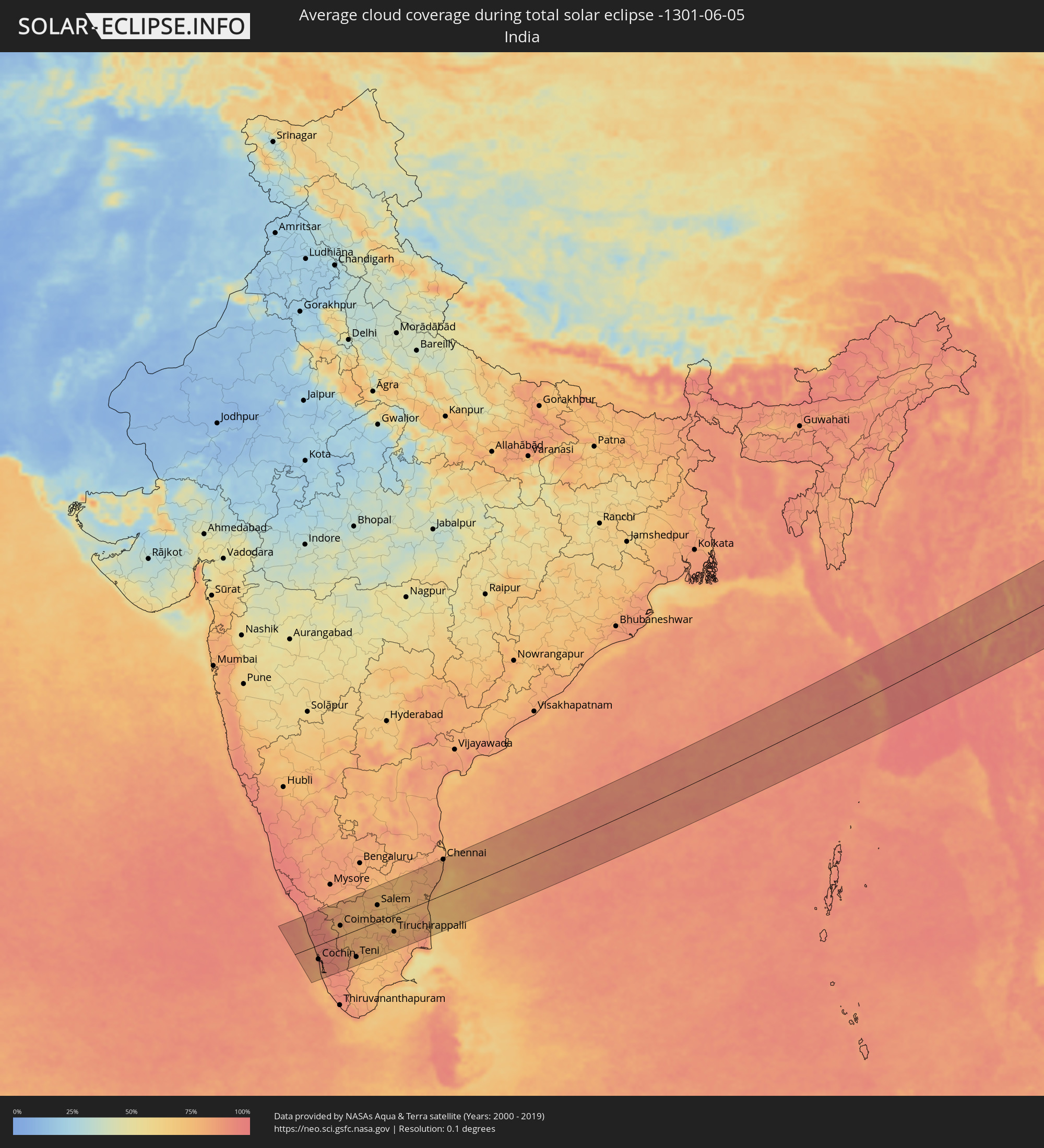 India
India
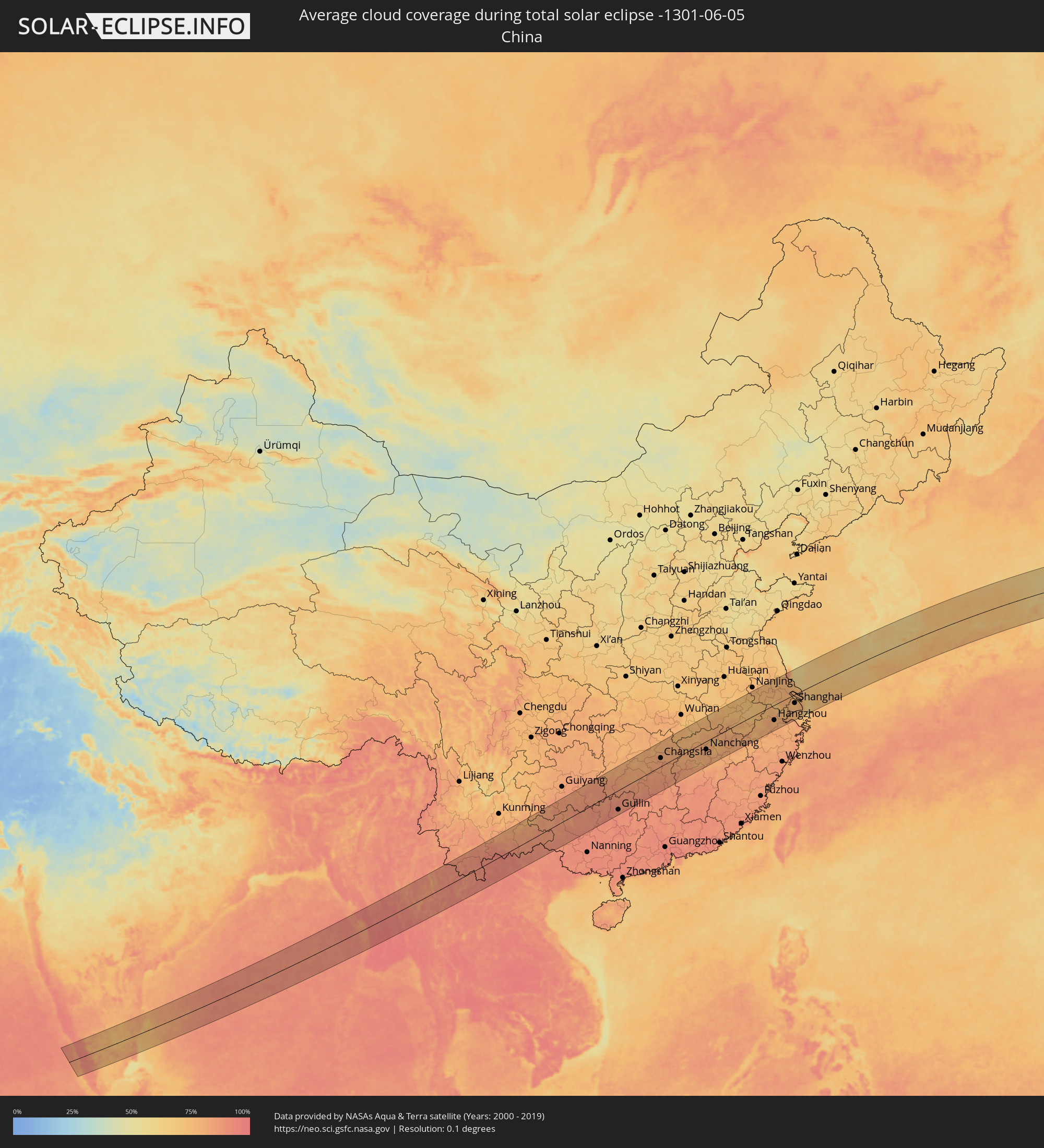 China
China
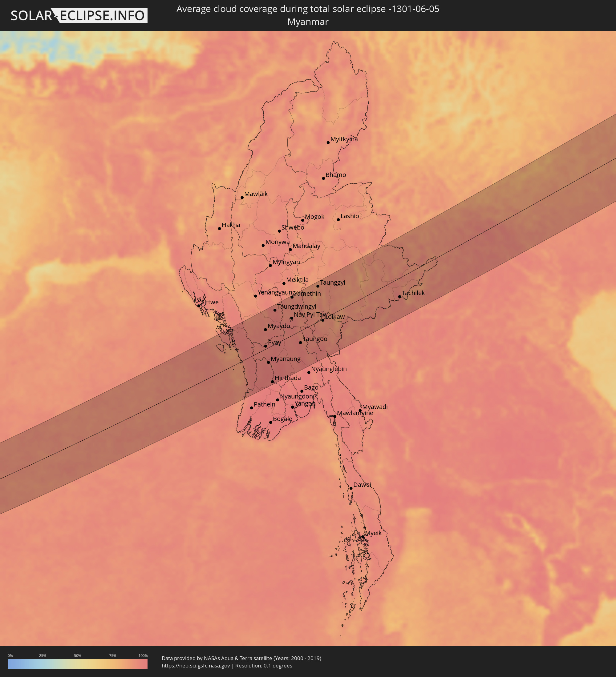 Myanmar
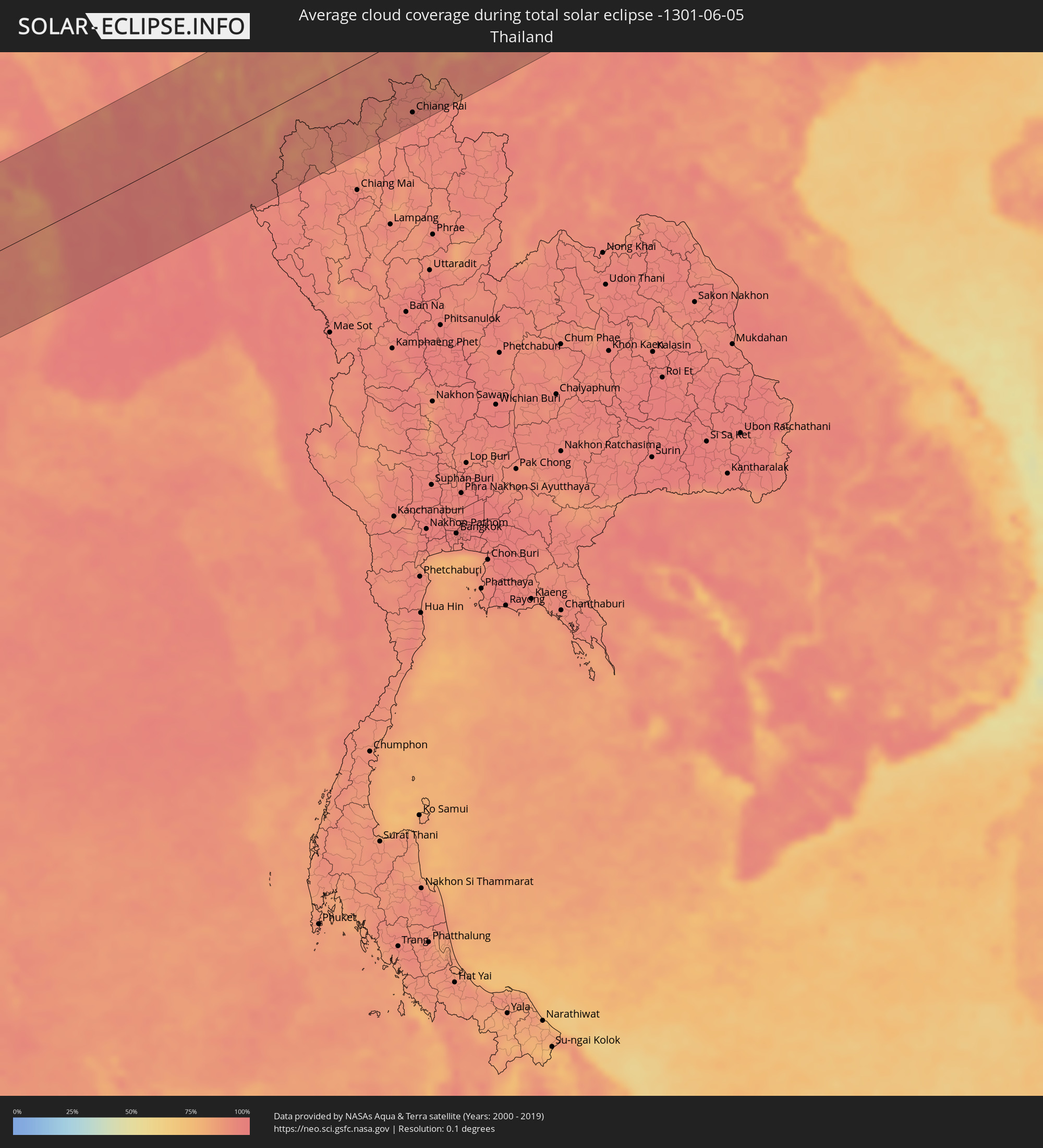 Thailand
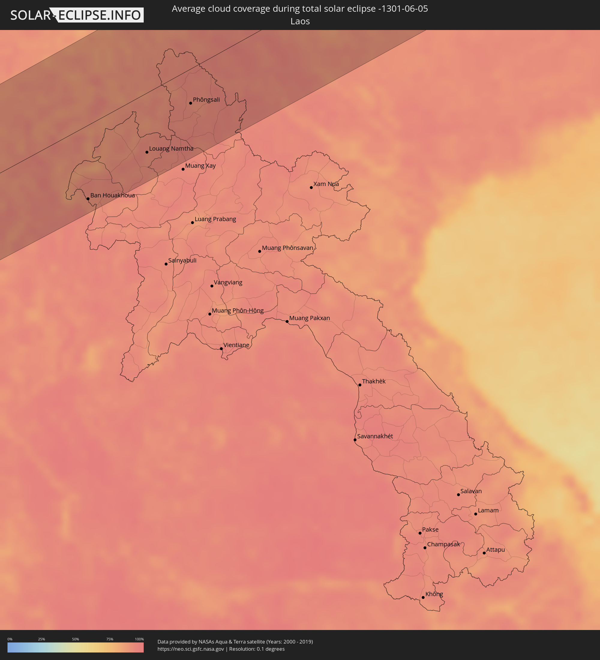 Laos
Laos
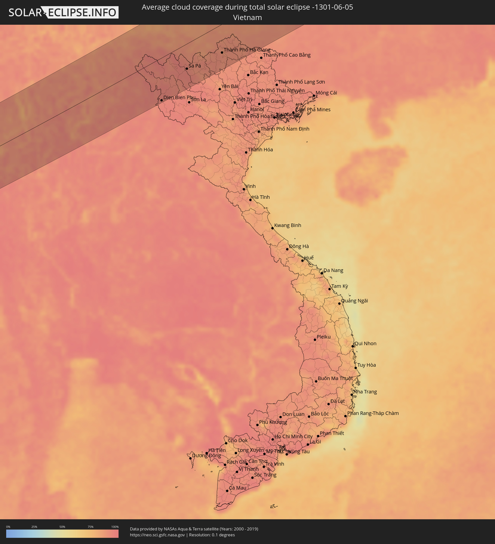 Vietnam
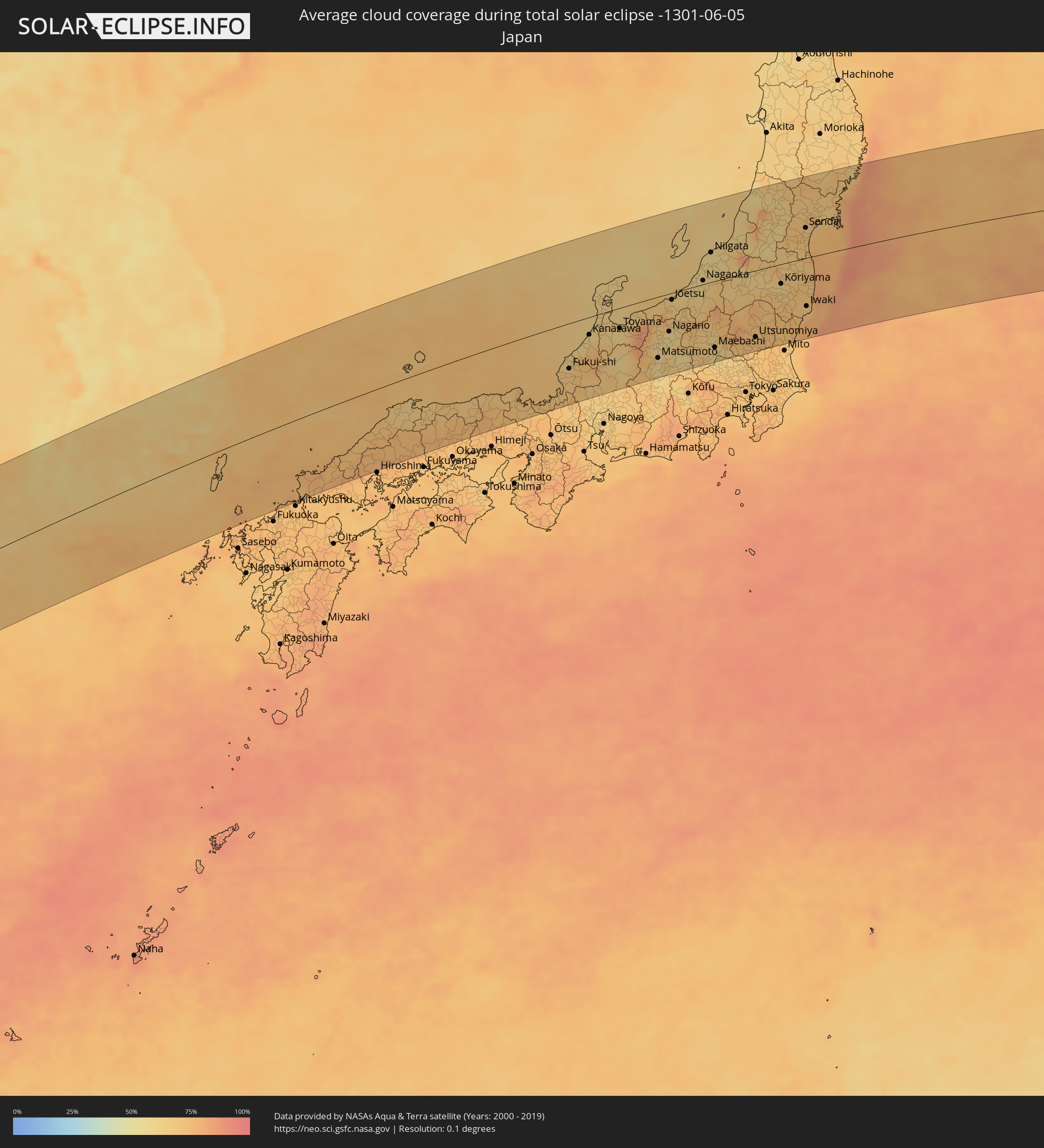 Japan
Japan
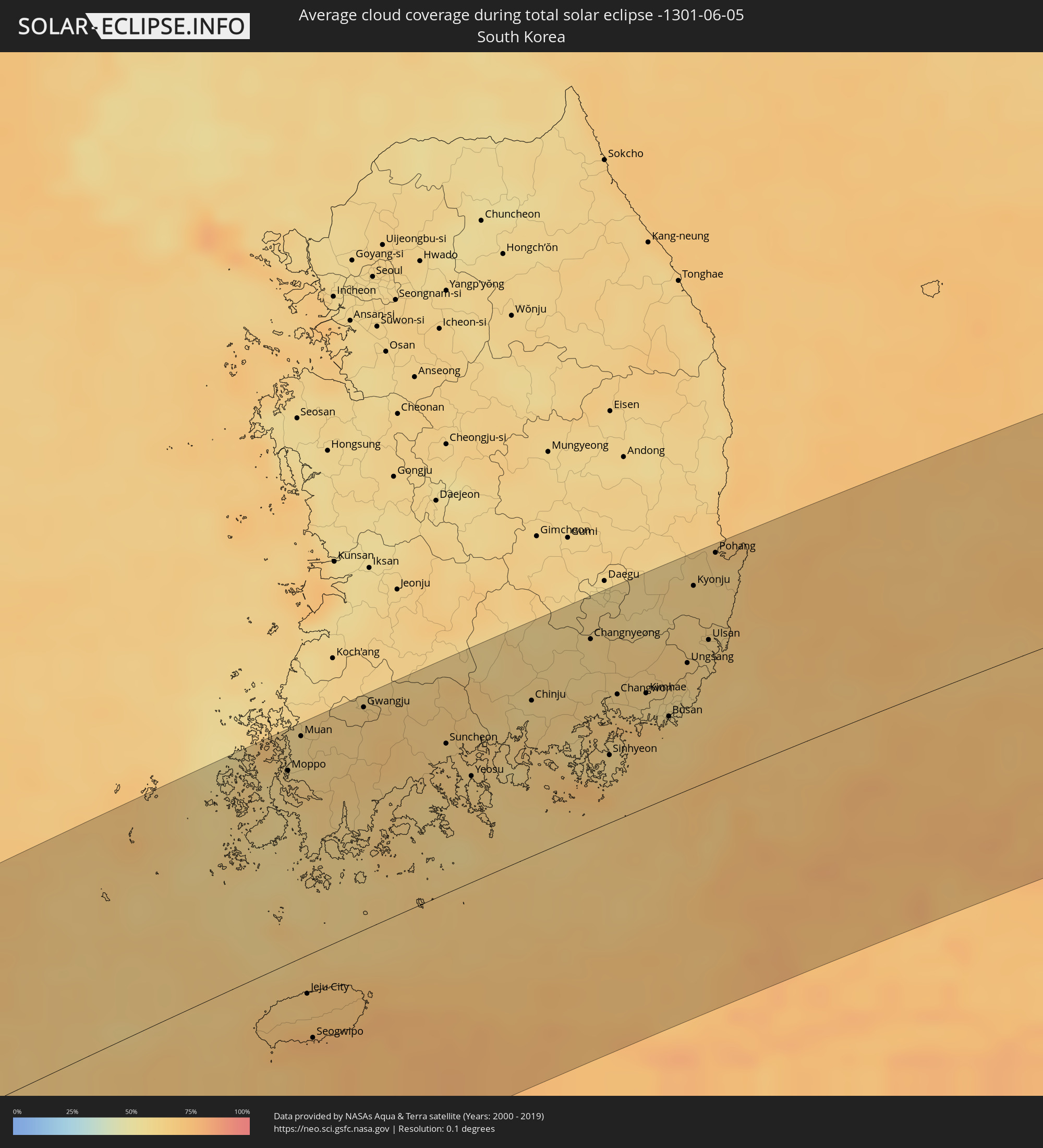 South Korea
Cities inside the path of the eclipse
The following table shows all locations with a population of more than 5,000 inside the eclipse path. Cities which have more than 100,000 inhabitants are marked bold. A click at the locations opens a detailed map.
| City | Type | Eclipse duration | Local time of max. eclipse | Distance to central line | Ø Cloud coverage |
|
Kozhikode, Kerala
|
total | - | 05:54:38 UTC+05:21 | 108 km | 84% |
|
Ponnāni, Kerala
|
total | - | 05:54:15 UTC+05:21 | 52 km | 84% |
|
Trichūr, Kerala
|
total | - | 05:54:00 UTC+05:21 | 14 km | 91% |
|
Cochin, Kerala
|
total | - | 05:53:36 UTC+05:21 | 47 km | 86% |
|
Alleppey, Kerala
|
total | - | 05:53:17 UTC+05:21 | 96 km | 79% |
|
Palakkad, Kerala
|
total | - | 05:54:05 UTC+05:21 | 24 km | 92% |
|
Ooty, Tamil Nadu
|
total | - | 05:54:32 UTC+05:21 | 88 km | 82% |
|
Coimbatore, Tamil Nadu
|
total | - | 05:54:11 UTC+05:21 | 35 km | 77% |
|
Tiruppur, Tamil Nadu
|
total | - | 05:54:11 UTC+05:21 | 31 km | 75% |
|
Teni, Tamil Nadu
|
total | - | 05:53:22 UTC+05:21 | 88 km | 76% |
|
Erode, Tamil Nadu
|
total | - | 05:54:16 UTC+05:21 | 39 km | 77% |
|
Dindigul, Tamil Nadu
|
total | - | 05:53:31 UTC+05:21 | 72 km | 77% |
|
Salem, Tamil Nadu
|
total | - | 05:54:25 UTC+05:21 | 53 km | 73% |
|
Tiruchirappalli, Tamil Nadu
|
total | - | 05:53:42 UTC+05:21 | 55 km | 78% |
|
Pudukkottai, Tamil Nadu
|
total | - | 05:53:22 UTC+05:21 | 105 km | 76% |
|
Tiruvannāmalai, Tamil Nadu
|
total | - | 05:54:42 UTC+05:21 | 75 km | 77% |
|
Thanjāvūr, Tamil Nadu
|
total | - | 05:53:36 UTC+05:21 | 76 km | 79% |
|
Kumbakonam, Tamil Nadu
|
total | - | 05:53:42 UTC+05:21 | 69 km | 78% |
|
Villupuram, Tamil Nadu
|
total | - | 05:54:25 UTC+05:21 | 28 km | 79% |
|
Kānchipuram, Tamil Nadu
|
total | - | 05:55:05 UTC+05:21 | 111 km | 80% |
|
Cuddalore, Tamil Nadu
|
total | - | 05:54:13 UTC+05:21 | 3 km | 75% |
|
Puducherry, Pondicherry
|
total | - | 05:54:21 UTC+05:21 | 13 km | 79% |
|
Nāgappattinam, Tamil Nadu
|
total | - | 05:53:29 UTC+05:21 | 108 km | 85% |
|
Pallāvaram, Tamil Nadu
|
total | - | 05:55:07 UTC+05:21 | 106 km | 79% |
|
Chennai, Tamil Nadu
|
total | - | 05:55:12 UTC+05:21 | 113 km | 79% |
|
Thayetmyo, Magway
|
total | - | 07:06:34 UTC+06:24 | 59 km | 93% |
|
Myaydo, Magway
|
total | - | 07:06:38 UTC+06:24 | 62 km | 94% |
|
Pyay, Bago
|
total | - | 07:06:02 UTC+06:24 | 8 km | 93% |
|
Myanaung, Ayeyarwady
|
total | - | 07:05:28 UTC+06:24 | 50 km | 95% |
|
Hinthada, Ayeyarwady
|
total | - | 07:04:50 UTC+06:24 | 120 km | 96% |
|
Paungde, Bago
|
total | - | 07:05:46 UTC+06:24 | 39 km | 97% |
|
Taungdwingyi, Magway
|
total | - | 07:07:29 UTC+06:24 | 109 km | 94% |
|
Letpandan, Bago
|
total | - | 07:05:06 UTC+06:24 | 120 km | 97% |
|
Nay Pyi Taw, Nay Pyi Taw
|
total | - | 07:07:25 UTC+06:24 | 55 km | 95% |
|
Yamethin, Mandalay
|
total | - | 07:08:13 UTC+06:24 | 122 km | 92% |
|
Pyinmana, Nay Pyi Taw
|
total | - | 07:07:27 UTC+06:24 | 50 km | 95% |
|
Taungoo, Bago
|
total | - | 07:06:39 UTC+06:24 | 39 km | 95% |
|
Pyu, Bago
|
total | - | 07:06:08 UTC+06:24 | 85 km | 97% |
|
Taunggyi, Shan
|
total | - | 07:09:02 UTC+06:24 | 113 km | 88% |
|
Loikaw, Kayah
|
total | - | 07:07:49 UTC+06:24 | 5 km | 89% |
|
Mae Hong Son, Mae Hong Son
|
total | - | 07:25:01 UTC+06:42 | 79 km | 90% |
|
Fang, Chiang Mai
|
total | - | 07:26:22 UTC+06:42 | 80 km | 90% |
|
Chiang Rai, Chiang Rai
|
total | - | 07:26:42 UTC+06:42 | 111 km | 94% |
|
Mae Chan, Chiang Rai
|
total | - | 07:27:00 UTC+06:42 | 89 km | 93% |
|
Mae Sai, Chiang Rai
|
total | - | 07:27:21 UTC+06:42 | 62 km | 94% |
|
Tachilek, Shan
|
total | - | 07:27:22 UTC+06:42 | 61 km | 94% |
|
Chiang Saen, Chiang Rai
|
total | - | 07:27:17 UTC+06:42 | 88 km | 90% |
|
Chiang Khong, Chiang Rai
|
total | - | 07:27:27 UTC+06:42 | 105 km | 90% |
|
Ban Houayxay, Bokeo Province
|
total | - | 07:27:28 UTC+06:42 | 104 km | 90% |
|
Ban Houakhoua, Bokeo Province
|
total | - | 07:27:27 UTC+06:42 | 109 km | 89% |
|
Louang Namtha, Loungnamtha
|
total | - | 07:28:53 UTC+06:42 | 87 km | 91% |
|
Phôngsali, Phôngsali
|
total | - | 07:30:14 UTC+06:42 | 51 km | 93% |
|
Dien Bien Phu, Tỉnh Ðiện Biên
|
total | - | 07:55:06 UTC+07:06 | 125 km | 94% |
|
Lai Châu, Lai Châu
|
total | - | 07:56:40 UTC+07:06 | 49 km | 93% |
|
Sa Pá, Lào Cai
|
total | - | 07:56:53 UTC+07:06 | 73 km | 95% |
|
Lào Cai, Lào Cai
|
total | - | 07:57:10 UTC+07:06 | 65 km | 91% |
|
Wenshan City, Yunnan
|
total | - | 08:51:50 UTC+08:00 | 6 km | 85% |
|
Thành Phố Hà Giang, Hà Giang
|
total | - | 07:58:23 UTC+07:06 | 83 km | 90% |
|
Guilin, Guangxi Zhuang Autonomous Region
|
total | - | 08:59:52 UTC+08:00 | 107 km | 90% |
|
Yiyang, Hunan
|
total | - | 09:06:45 UTC+08:00 | 114 km | 81% |
|
Hengyang, Hunan
|
total | - | 09:04:41 UTC+08:00 | 65 km | 88% |
|
Xiangtan, Hunan
|
total | - | 09:06:22 UTC+08:00 | 15 km | 82% |
|
Changsha, Hunan
|
total | - | 09:06:56 UTC+08:00 | 45 km | 82% |
|
Zhuzhou, Hunan
|
total | - | 09:06:38 UTC+08:00 | 1 km | 84% |
|
Guankou, Hunan
|
total | - | 09:07:40 UTC+08:00 | 10 km | 81% |
|
Pingxiang, Jiangxi
|
total | - | 09:07:11 UTC+08:00 | 53 km | 83% |
|
Wuxue, Hubei
|
total | - | 09:12:30 UTC+08:00 | 84 km | 77% |
|
Nanchang, Jiangxi
|
total | - | 09:11:14 UTC+08:00 | 44 km | 82% |
|
Jiujiang, Jiangxi
|
total | - | 09:12:53 UTC+08:00 | 49 km | 77% |
|
Anqing, Anhui
|
total | - | 09:15:27 UTC+08:00 | 80 km | 76% |
|
Jingdezhen, Jiangxi
|
total | - | 09:13:56 UTC+08:00 | 47 km | 85% |
|
Wusong, Anhui
|
total | - | 09:17:06 UTC+08:00 | 89 km | 74% |
|
Wuhu, Anhui
|
total | - | 09:18:29 UTC+08:00 | 100 km | 72% |
|
Changzhou, Jiangsu
|
total | - | 09:21:25 UTC+08:00 | 73 km | 76% |
|
Hangzhou, Zhejiang
|
total | - | 09:19:39 UTC+08:00 | 82 km | 77% |
|
Wuxi, Jiangsu
|
total | - | 09:21:38 UTC+08:00 | 39 km | 75% |
|
Shaoxing, Zhejiang
|
total | - | 09:19:53 UTC+08:00 | 129 km | 81% |
|
Suzhou, Jiangsu
|
total | - | 09:21:44 UTC+08:00 | 1 km | 78% |
|
Changshu City, Jiangsu
|
total | - | 09:22:26 UTC+08:00 | 27 km | 78% |
|
Jiaxing, Zhejiang
|
total | - | 09:21:12 UTC+08:00 | 62 km | 76% |
|
Nantong, Jiangsu
|
total | - | 09:23:11 UTC+08:00 | 59 km | 77% |
|
Shanghai, Shanghai
|
total | - | 09:22:58 UTC+08:00 | 46 km | 75% |
|
Sinan, Jeollanam-do
|
total | - | 10:03:24 UTC+08:27 | 127 km | 63% |
|
Moppo, Jeollanam-do
|
total | - | 10:03:51 UTC+08:27 | 113 km | 65% |
|
Muan, Jeollanam-do
|
total | - | 10:04:16 UTC+08:27 | 129 km | 62% |
|
Jeju City, Jeju-do
|
total | - | 10:02:27 UTC+08:27 | 23 km | 67% |
|
Seogwipo, Jeju-do
|
total | - | 10:02:12 UTC+08:27 | 50 km | 77% |
|
Gwangju, Gwangju
|
total | - | 10:05:14 UTC+08:27 | 130 km | 65% |
|
Hwasun, Jeollanam-do
|
total | - | 10:05:15 UTC+08:27 | 117 km | 66% |
|
Suncheon, Jeollanam-do
|
total | - | 10:06:00 UTC+08:27 | 87 km | 65% |
|
Kwangyang, Jeollanam-do
|
total | - | 10:06:13 UTC+08:27 | 87 km | 66% |
|
Yeosu, Jeollanam-do
|
total | - | 10:06:05 UTC+08:27 | 62 km | 63% |
|
Chinju, Gyeongsangnam-do
|
total | - | 10:07:23 UTC+08:27 | 91 km | 61% |
|
Changnyeong, Gyeongsangnam-do
|
total | - | 10:08:33 UTC+08:27 | 112 km | 61% |
|
Naesŏ, Gyeongsangnam-do
|
total | - | 10:08:14 UTC+08:27 | 81 km | 63% |
|
Kyosai, Gyeongsangnam-do
|
total | - | 10:07:53 UTC+08:27 | 38 km | 59% |
|
Sinhyeon, Gyeongsangnam-do
|
total | - | 10:07:59 UTC+08:27 | 40 km | 59% |
|
Changwon, Gyeongsangnam-do
|
total | - | 10:08:30 UTC+08:27 | 73 km | 64% |
|
Gyeongsan-si, Gyeongsangbuk-do
|
total | - | 10:09:19 UTC+08:27 | 132 km | 61% |
|
Miryang, Gyeongsangnam-do
|
total | - | 10:08:57 UTC+08:27 | 98 km | 65% |
|
Kimhae, Gyeongsangnam-do
|
total | - | 10:08:53 UTC+08:27 | 67 km | 60% |
|
Yangsan, Gyeongsangnam-do
|
total | - | 10:09:18 UTC+08:27 | 72 km | 61% |
|
Busan, Busan
|
total | - | 10:09:01 UTC+08:27 | 48 km | 67% |
|
Ungsang, Gyeongsangnam-do
|
total | - | 10:09:37 UTC+08:27 | 74 km | 63% |
|
Kyonju, Gyeongsangbuk-do
|
total | - | 10:10:13 UTC+08:27 | 118 km | 64% |
|
Ulsan, Ulsan
|
total | - | 10:10:03 UTC+08:27 | 83 km | 62% |
|
Pohang, Gyeongsangbuk-do
|
total | - | 10:10:43 UTC+08:27 | 132 km | 64% |
|
Yamaguchi, Yamaguchi
|
total | - | 10:44:45 UTC+09:00 | 130 km | 75% |
|
Matsue, Shimane
|
total | - | 10:49:20 UTC+09:00 | 45 km | 64% |
|
Yonago, Tottori
|
total | - | 10:49:51 UTC+09:00 | 59 km | 66% |
|
Tottori, Tottori
|
total | - | 10:51:44 UTC+09:00 | 79 km | 68% |
|
Fukui-shi, Fukui
|
total | - | 10:56:23 UTC+09:00 | 76 km | 65% |
|
Komatsu, Ishikawa
|
total | - | 10:57:10 UTC+09:00 | 46 km | 66% |
|
Kanazawa, Ishikawa
|
total | - | 10:57:41 UTC+09:00 | 29 km | 62% |
|
Takaoka, Toyama
|
total | - | 10:58:39 UTC+09:00 | 24 km | 63% |
|
Toyama, Toyama
|
total | - | 10:59:01 UTC+09:00 | 34 km | 61% |
|
Matsumoto, Nagano
|
total | - | 11:00:13 UTC+09:00 | 103 km | 61% |
|
Nagano, Nagano
|
total | - | 11:01:01 UTC+09:00 | 64 km | 61% |
|
Jōetsu, Niigata
|
total | - | 11:01:31 UTC+09:00 | 12 km | 66% |
|
Ueda, Nagano
|
total | - | 11:01:01 UTC+09:00 | 93 km | 57% |
|
Nagaoka, Niigata
|
total | - | 11:03:02 UTC+09:00 | 6 km | 63% |
|
Niigata, Niigata
|
total | - | 11:03:41 UTC+09:00 | 50 km | 59% |
|
Maebashi, Gunma
|
total | - | 11:02:44 UTC+09:00 | 112 km | 60% |
|
Ashikaga, Tochigi
|
total | - | 11:03:29 UTC+09:00 | 128 km | 65% |
|
Utsunomiya, Tochigi
|
total | - | 11:04:35 UTC+09:00 | 112 km | 69% |
|
Yamagata, Yamagata
|
total | - | 11:06:45 UTC+09:00 | 57 km | 69% |
|
Kōriyama, Fukushima
|
total | - | 11:06:14 UTC+09:00 | 33 km | 64% |
|
Fukushima, Fukushima
|
total | - | 11:06:39 UTC+09:00 | 3 km | 67% |
|
Hitachi, Ibaraki
|
total | - | 11:06:16 UTC+09:00 | 125 km | 74% |
|
Sendai, Miyagi
|
total | - | 11:07:49 UTC+09:00 | 51 km | 69% |
|
Iwaki, Fukushima
|
total | - | 11:07:04 UTC+09:00 | 81 km | 67% |
|
Ishinomaki, Miyagi
|
total | - | 11:08:49 UTC+09:00 | 58 km | 73% |