Total solar eclipse of 06/03/-1347
| Day of week: | Wednesday |
| Maximum duration of eclipse: | 02m09s |
| Maximum width of eclipse path: | 97 km |
| Saros cycle: | 35 |
| Coverage: | 100% |
| Magnitude: | 1.026 |
| Gamma: | 0.4146 |
Wo kann man die Sonnenfinsternis vom 06/03/-1347 sehen?
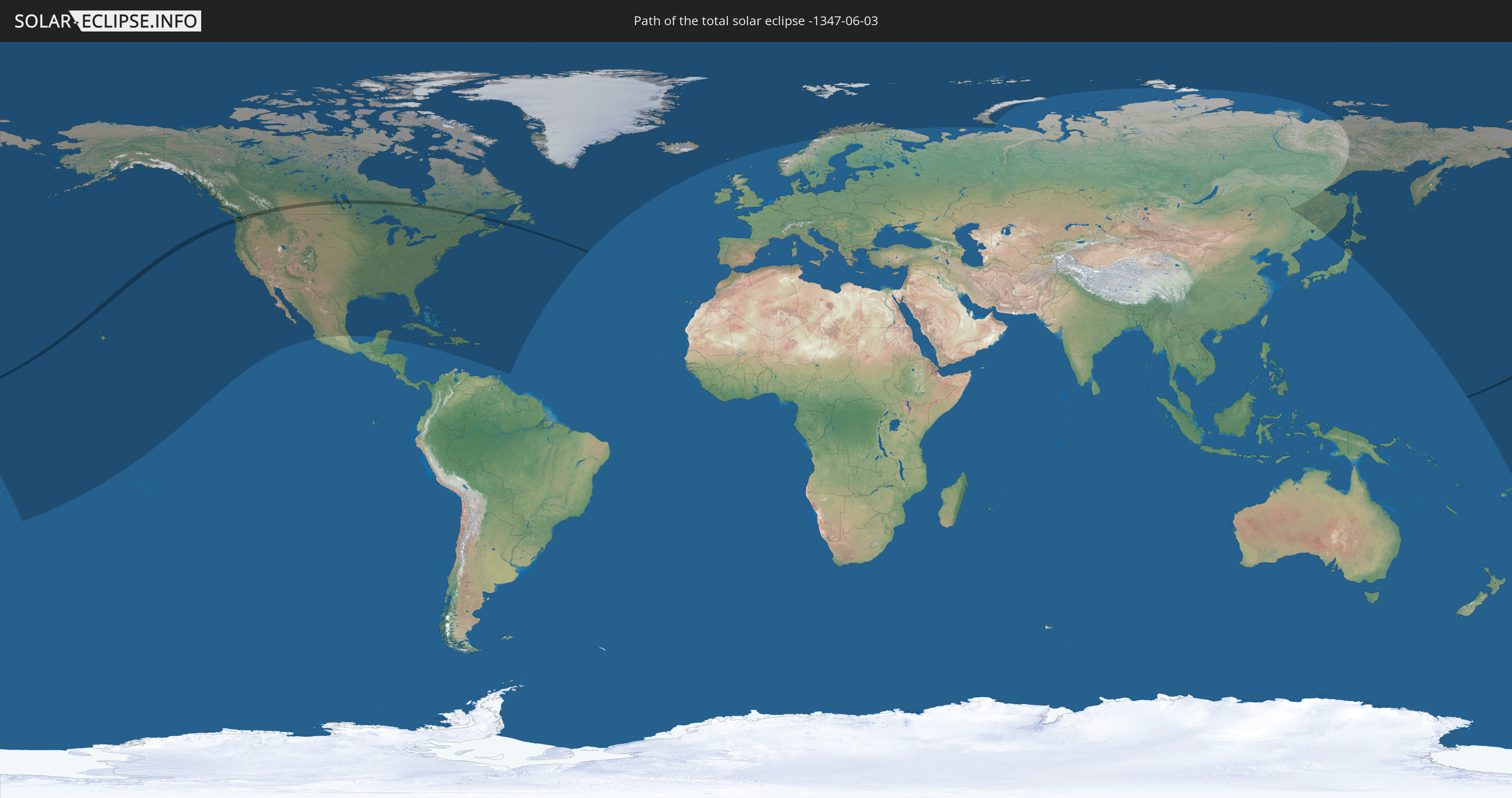
Die Sonnenfinsternis am 06/03/-1347 kann man in 49 Ländern als partielle Sonnenfinsternis beobachten.
Der Finsternispfad verläuft durch 4 Länder. Nur in diesen Ländern ist sie als total Sonnenfinsternis zu sehen.
In den folgenden Ländern ist die Sonnenfinsternis total zu sehen
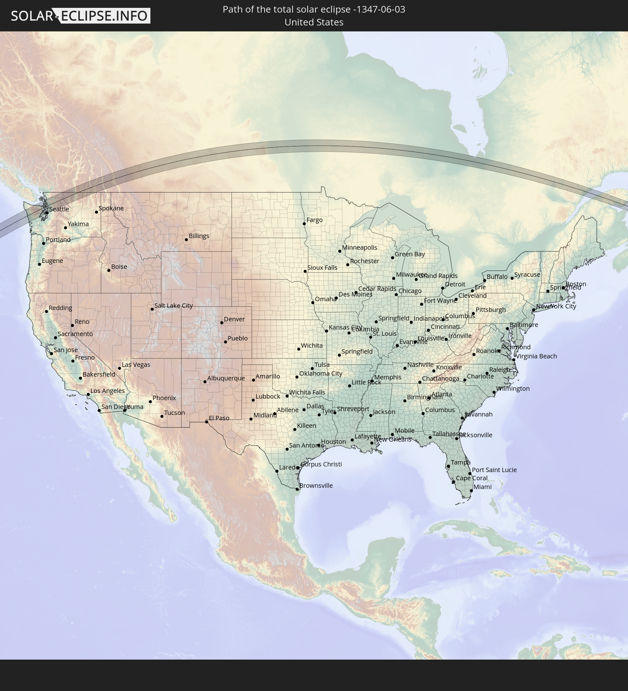 United States
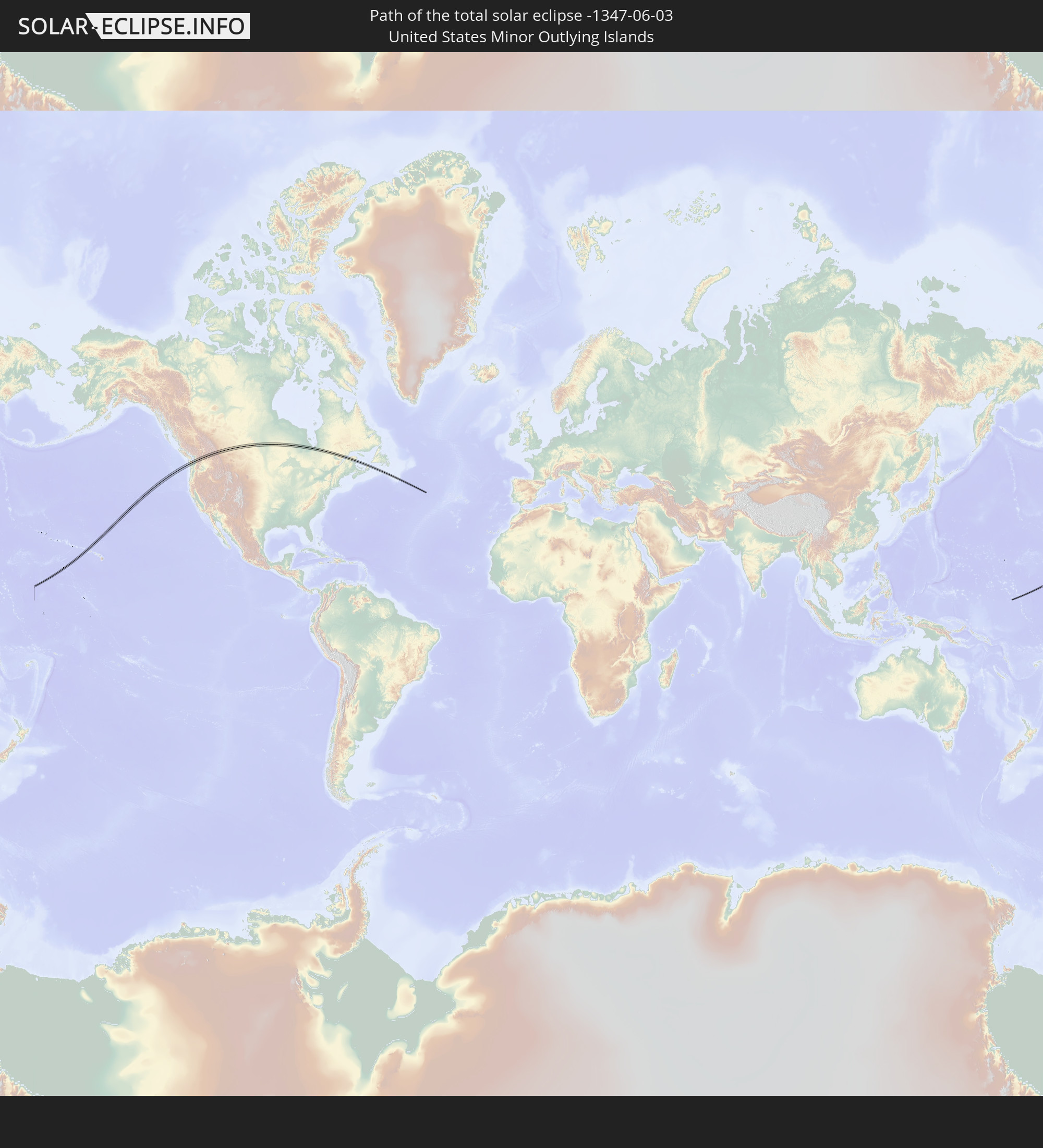 United States Minor Outlying Islands
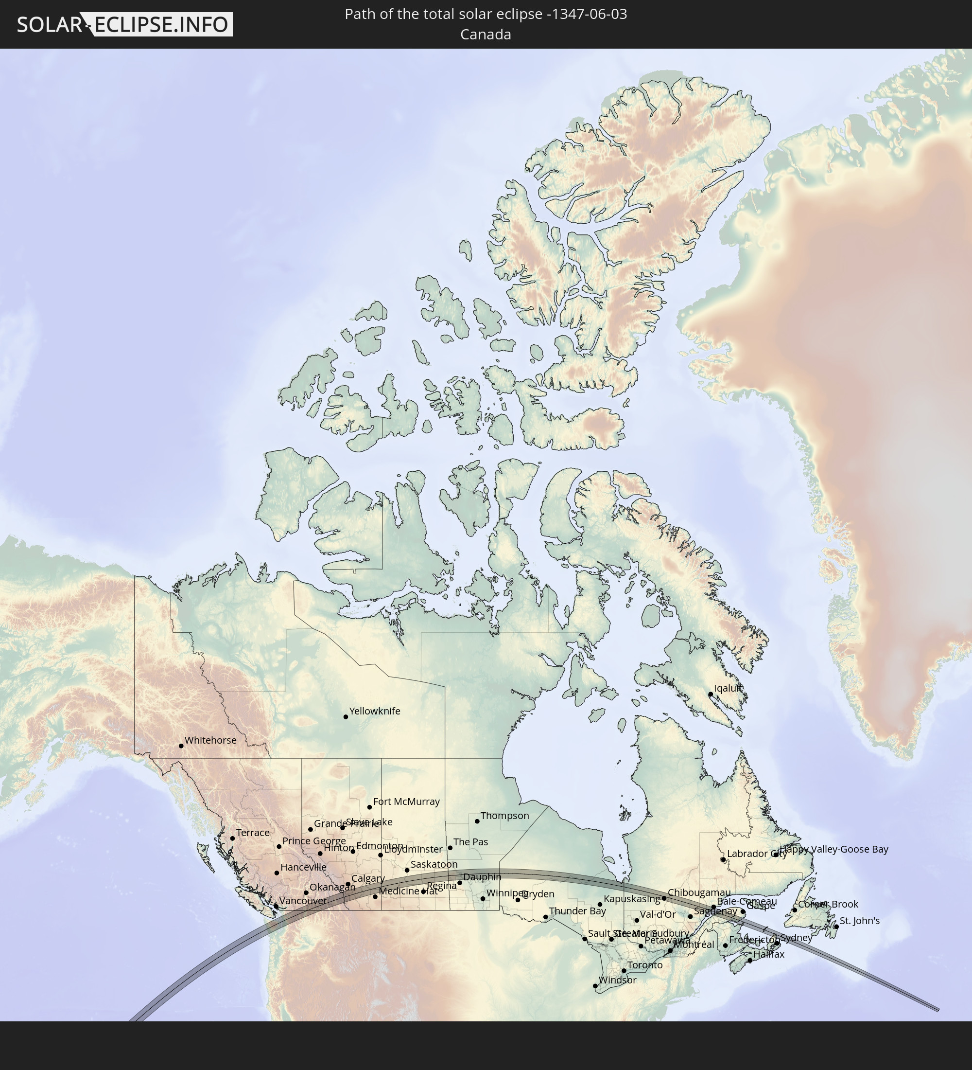 Canada
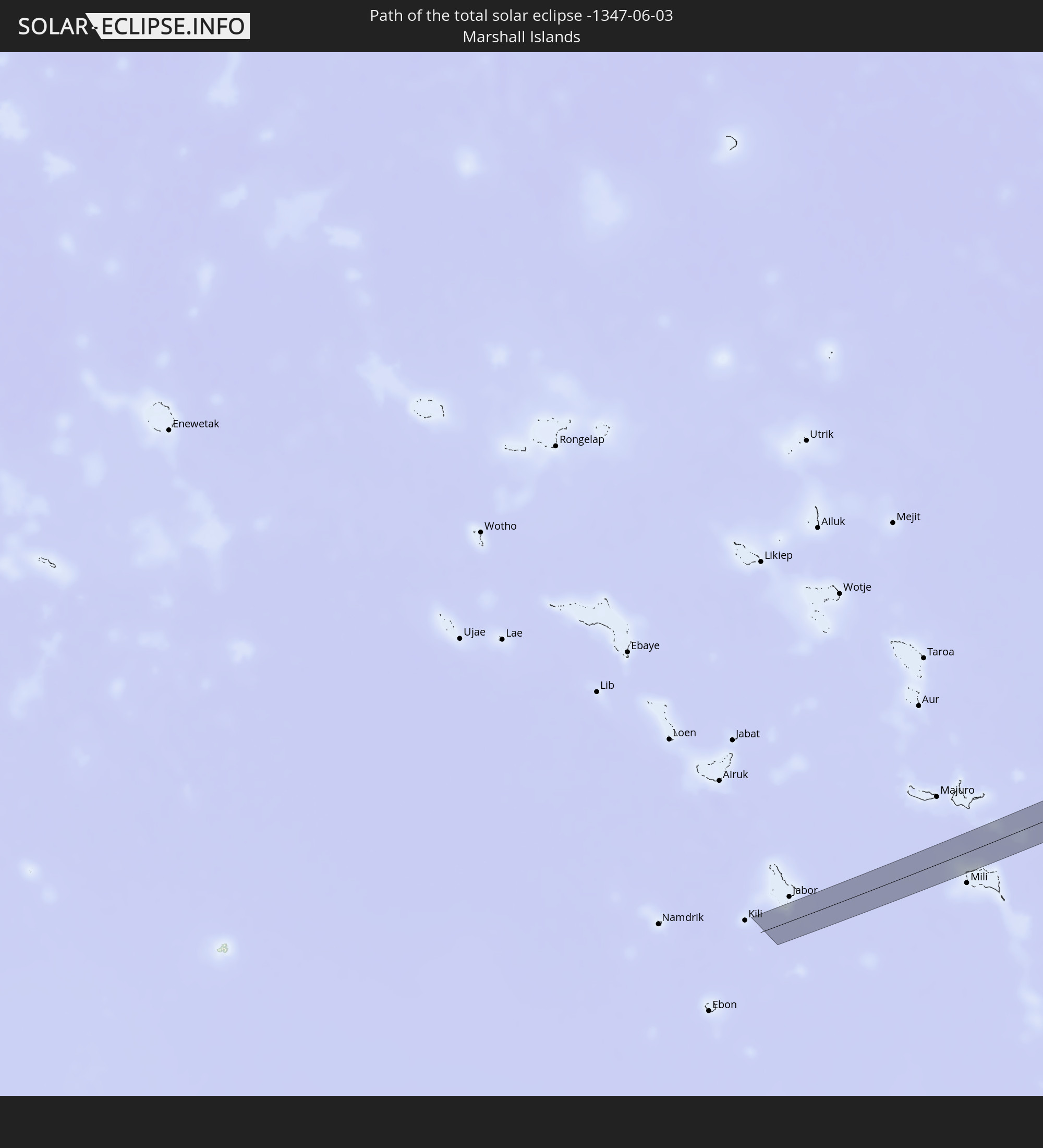 Marshall Islands
In den folgenden Ländern ist die Sonnenfinsternis partiell zu sehen
 Russia
 United States
 United States Minor Outlying Islands
 Wallis and Futuna
 Tonga
Tonga
 Kiribati
 Samoa
Samoa
 Tokelau
 American Samoa
 Niue
Niue
 Cook Islands
 Canada
 Mexico
 Greenland
 Cuba
Cuba
 Cayman Islands
 The Bahamas
 Jamaica
 Haiti
Haiti
 Turks and Caicos Islands
 Dominican Republic
 Puerto Rico
 United States Virgin Islands
 Bermuda
 British Virgin Islands
 Anguilla
 Collectivity of Saint Martin
 Saint Barthélemy
 Saint Kitts and Nevis
 Antigua and Barbuda
 Montserrat
 Guadeloupe
 Grenada
 Dominica
 Saint Vincent and the Grenadines
 Martinique
 Saint Lucia
 Barbados
 Saint Pierre and Miquelon
 Iceland
 Svalbard and Jan Mayen
 Faroe Islands
 Norway
 Sweden
 Finland
 China
China
 Japan
Japan
 Marshall Islands
 Tuvalu
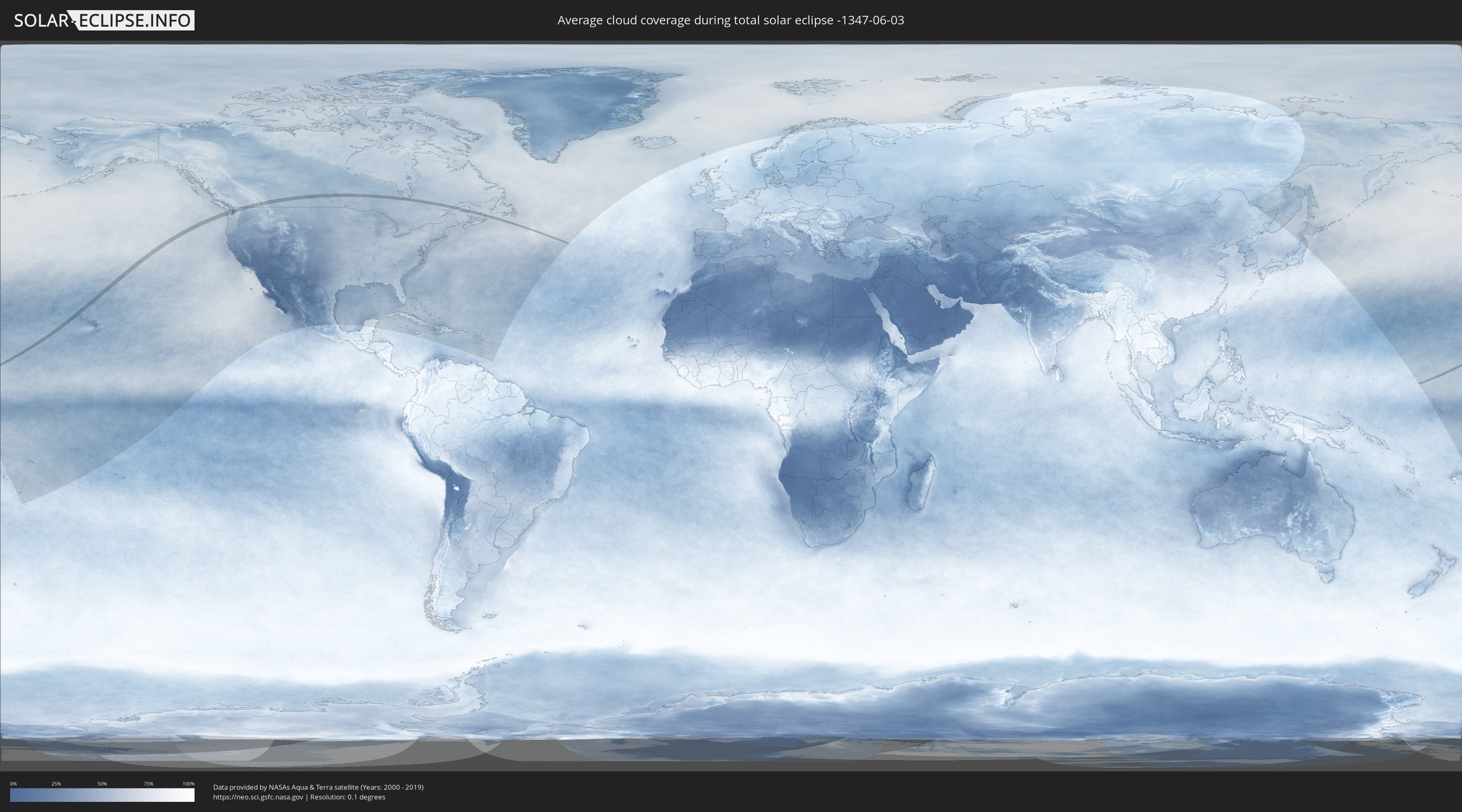
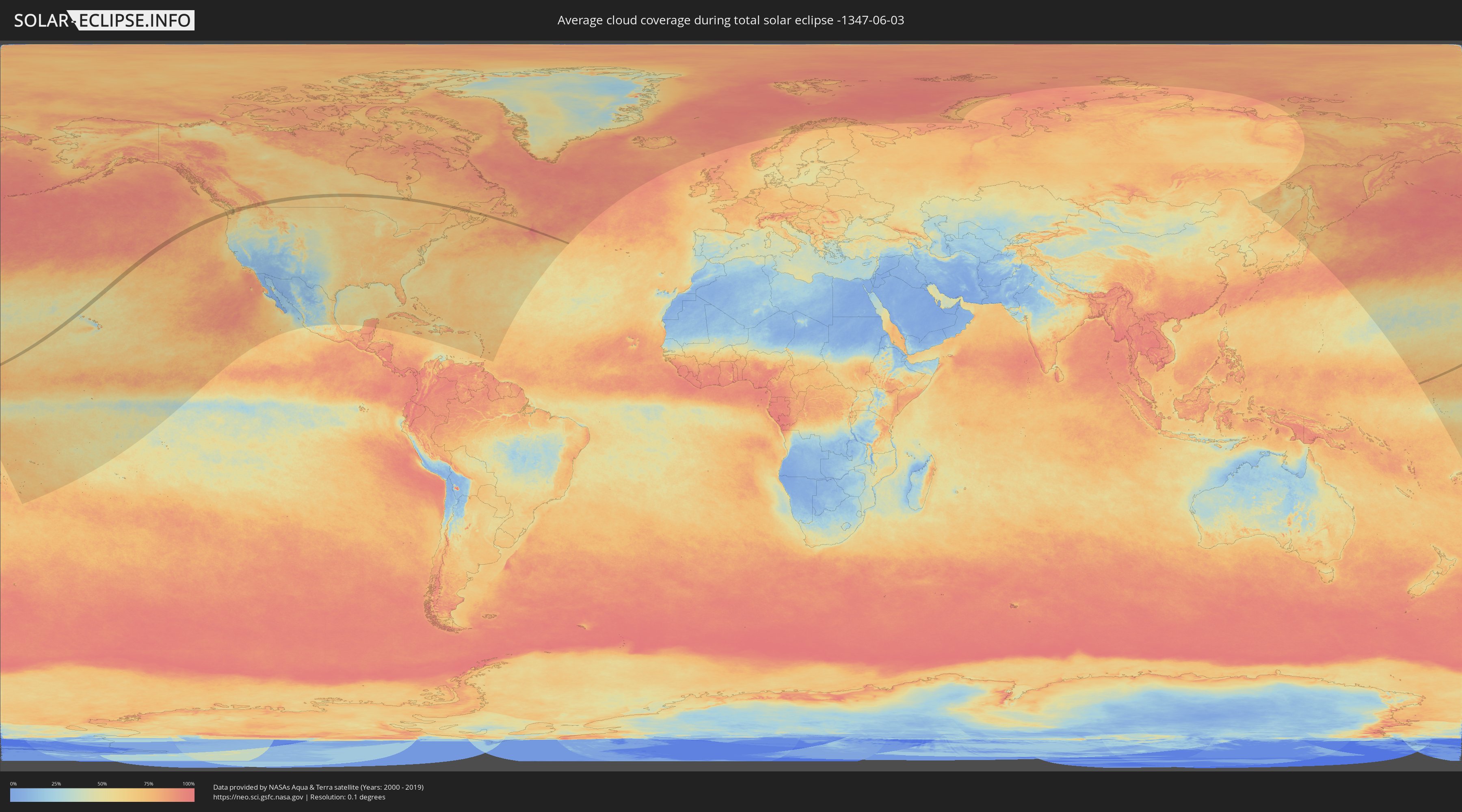
How will be the weather during the total solar eclipse on 06/03/-1347?
Where is the best place to see the total solar eclipse of 06/03/-1347?
The following maps show the average cloud coverage for the day of the total solar eclipse.
With the help of these maps, it is possible to find the place along the eclipse path, which has the best
chance of a cloudless sky.
Nevertheless, you should consider local circumstances and inform about the weather of your chosen
observation site.
The data is provided by NASAs satellites
AQUA and TERRA.
The cloud maps are averaged over a period of 19 years (2000 - 2019).
Detailed country maps
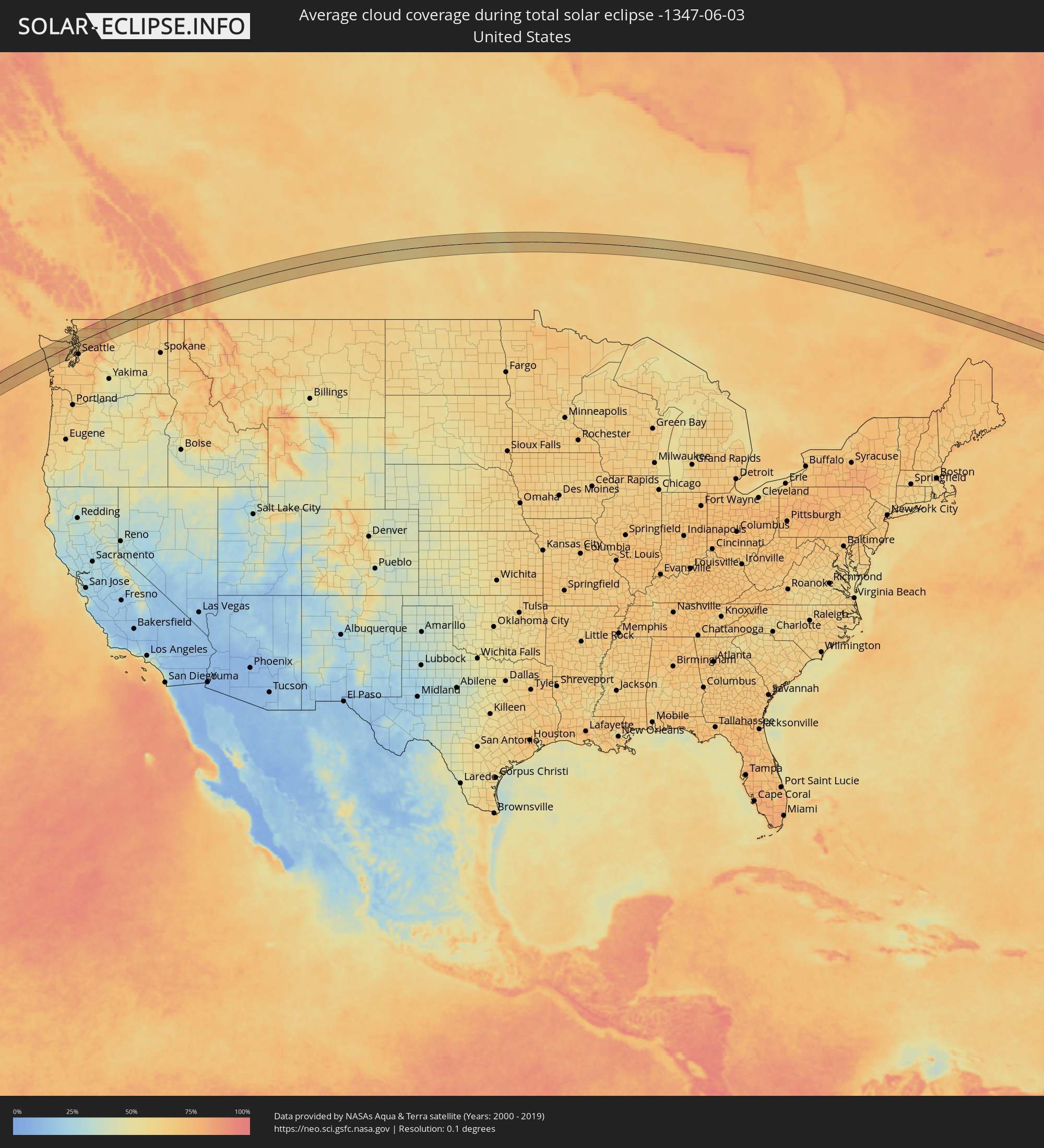 United States
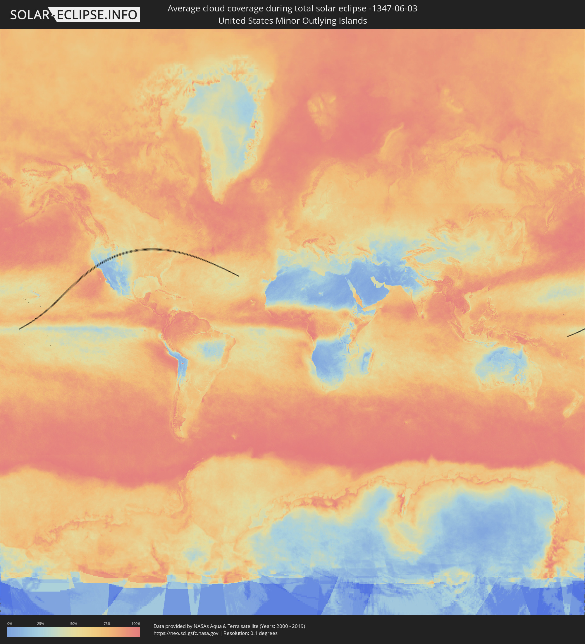 United States Minor Outlying Islands
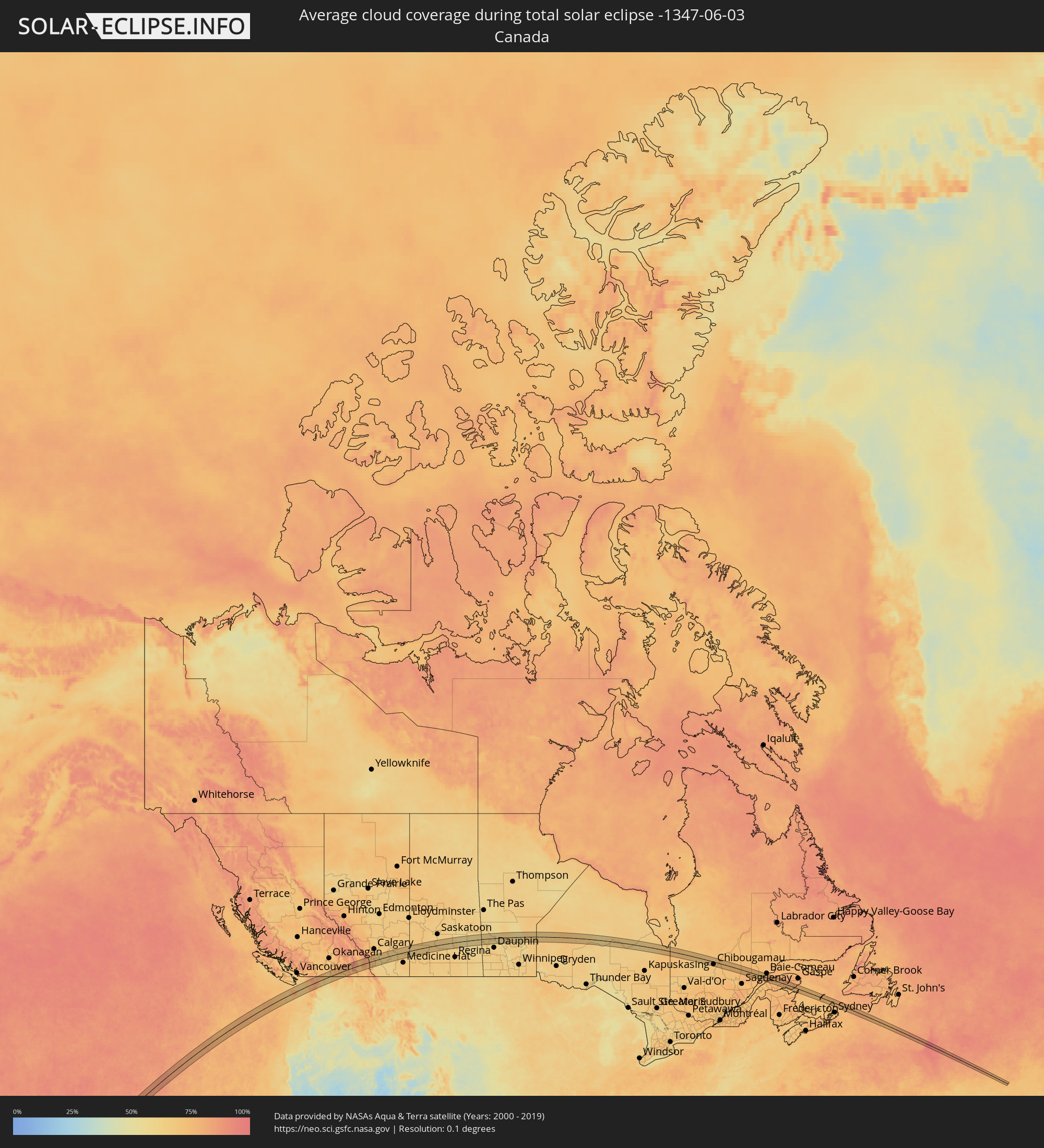 Canada
 Marshall Islands
Cities inside the path of the eclipse
The following table shows all locations with a population of more than 5,000 inside the eclipse path. Cities which have more than 100,000 inhabitants are marked bold. A click at the locations opens a detailed map.
| City | Type | Eclipse duration | Local time of max. eclipse | Distance to central line | Ø Cloud coverage |
|
Port Angeles, Washington
|
total | - | 12:26:25 UTC-08:00 | 37 km | 70% |
|
Sequim, Washington
|
total | - | 12:26:55 UTC-08:00 | 23 km | 67% |
|
Port Townsend, Washington
|
total | - | 12:27:31 UTC-08:00 | 15 km | 63% |
|
Bangor Trident Base, Washington
|
total | - | 12:27:15 UTC-08:00 | 26 km | 65% |
|
Silverdale, Washington
|
total | - | 12:27:13 UTC-08:00 | 34 km | 64% |
|
Tracyton, Washington
|
total | - | 12:27:16 UTC-08:00 | 39 km | 64% |
|
Poulsbo, Washington
|
total | - | 12:27:23 UTC-08:00 | 26 km | 63% |
|
Oak Harbor, Washington
|
total | - | 12:27:51 UTC-08:00 | 29 km | 65% |
|
Port Orchard, Washington
|
total | - | 12:27:14 UTC-08:00 | 46 km | 63% |
|
Bremerton, Washington
|
total | - | 12:27:16 UTC-08:00 | 44 km | 64% |
|
Camano, Washington
|
total | - | 12:27:56 UTC-08:00 | 14 km | 64% |
|
Bainbridge Island, Washington
|
total | - | 12:27:30 UTC-08:00 | 42 km | 65% |
|
Edmonds, Washington
|
total | - | 12:27:53 UTC-08:00 | 28 km | 64% |
|
Stanwood, Washington
|
total | - | 12:28:15 UTC-08:00 | 16 km | 65% |
|
Shoreline, Washington
|
total | - | 12:27:54 UTC-08:00 | 34 km | 65% |
|
Mount Vernon, Washington
|
total | - | 12:28:27 UTC-08:00 | 33 km | 68% |
|
Burlington, Washington
|
total | - | 12:28:30 UTC-08:00 | 38 km | 68% |
|
Lynnwood, Washington
|
total | - | 12:28:00 UTC-08:00 | 29 km | 65% |
|
Mountlake Terrace, Washington
|
total | - | 12:27:59 UTC-08:00 | 32 km | 65% |
|
Mukilteo, Washington
|
total | - | 12:28:07 UTC-08:00 | 16 km | 66% |
|
Tulalip, Washington
|
total | - | 12:28:14 UTC-08:00 | 4 km | 66% |
|
Alderwood Manor, Washington
|
total | - | 12:28:03 UTC-08:00 | 30 km | 65% |
|
Lake Forest Park, Washington
|
total | - | 12:28:00 UTC-08:00 | 36 km | 65% |
|
Brier, Washington
|
total | - | 12:28:02 UTC-08:00 | 34 km | 65% |
|
Kenmore, Washington
|
total | - | 12:28:04 UTC-08:00 | 37 km | 67% |
|
Martha Lake, Washington
|
total | - | 12:28:09 UTC-08:00 | 28 km | 68% |
|
Sedro-Woolley, Washington
|
total | - | 12:28:40 UTC-08:00 | 38 km | 69% |
|
Inglewood-Finn Hill, Washington
|
total | - | 12:28:03 UTC-08:00 | 41 km | 66% |
|
Kirkland, Washington
|
total | - | 12:28:04 UTC-08:00 | 46 km | 66% |
|
Bothell, Washington
|
total | - | 12:28:08 UTC-08:00 | 38 km | 67% |
|
Mill Creek, Washington
|
total | - | 12:28:13 UTC-08:00 | 28 km | 68% |
|
Everett, Washington
|
total | - | 12:28:19 UTC-08:00 | 16 km | 66% |
|
Kingsgate, Washington
|
total | - | 12:28:09 UTC-08:00 | 42 km | 66% |
|
Marysville, Washington
|
total | - | 12:28:25 UTC-08:00 | 10 km | 65% |
|
North Creek, Washington
|
total | - | 12:28:14 UTC-08:00 | 33 km | 67% |
|
Woodinville, Washington
|
total | - | 12:28:12 UTC-08:00 | 40 km | 67% |
|
Silver Firs, Washington
|
total | - | 12:28:18 UTC-08:00 | 29 km | 68% |
|
Arlington, Washington
|
total | - | 12:28:37 UTC-08:00 | 4 km | 70% |
|
Maltby, Washington
|
total | - | 12:28:19 UTC-08:00 | 37 km | 68% |
|
West Lake Stevens, Washington
|
total | - | 12:28:30 UTC-08:00 | 18 km | 66% |
|
Snohomish, Washington
|
total | - | 12:28:26 UTC-08:00 | 26 km | 68% |
|
Cottage Lake, Washington
|
total | - | 12:28:20 UTC-08:00 | 44 km | 67% |
|
Lake Stevens, Washington
|
total | - | 12:28:34 UTC-08:00 | 17 km | 66% |
|
Monroe, Washington
|
total | - | 12:28:36 UTC-08:00 | 36 km | 68% |
|
Woods Creek, Washington
|
total | - | 12:28:44 UTC-08:00 | 36 km | 69% |
|
Trail, British Columbia
|
total | - | 12:36:24 UTC-08:00 | 30 km | 67% |
|
Castlegar, British Columbia
|
total | - | 12:36:34 UTC-08:00 | 10 km | 70% |
|
Nelson, British Columbia
|
total | - | 12:37:16 UTC-08:00 | 1 km | 76% |
|
Kimberley, British Columbia
|
total | - | 13:05:33 UTC-07:33 | 13 km | 70% |
|
Cranbrook, British Columbia
|
total | - | 13:05:49 UTC-07:33 | 36 km | 68% |
|
High River, Alberta
|
total | - | 13:09:07 UTC-07:33 | 37 km | 67% |
|
Brooks, Alberta
|
total | - | 13:12:07 UTC-07:33 | 1 km | 65% |
|
Chibougamau, Quebec
|
total | - | 16:27:57 UTC-05:00 | 20 km | 68% |
|
Matane, Quebec
|
total | - | 16:32:30 UTC-05:00 | 9 km | 74% |
|
Amqui, Quebec
|
total | - | 16:32:57 UTC-05:00 | 27 km | 75% |
|
Chandler, Quebec
|
total | - | 16:34:02 UTC-05:00 | 29 km | 79% |