Total solar eclipse of 08/05/-1369
| Day of week: | Wednesday |
| Maximum duration of eclipse: | 03m41s |
| Maximum width of eclipse path: | 140 km |
| Saros cycle: | 33 |
| Coverage: | 100% |
| Magnitude: | 1.041 |
| Gamma: | 0.2075 |
Wo kann man die Sonnenfinsternis vom 08/05/-1369 sehen?
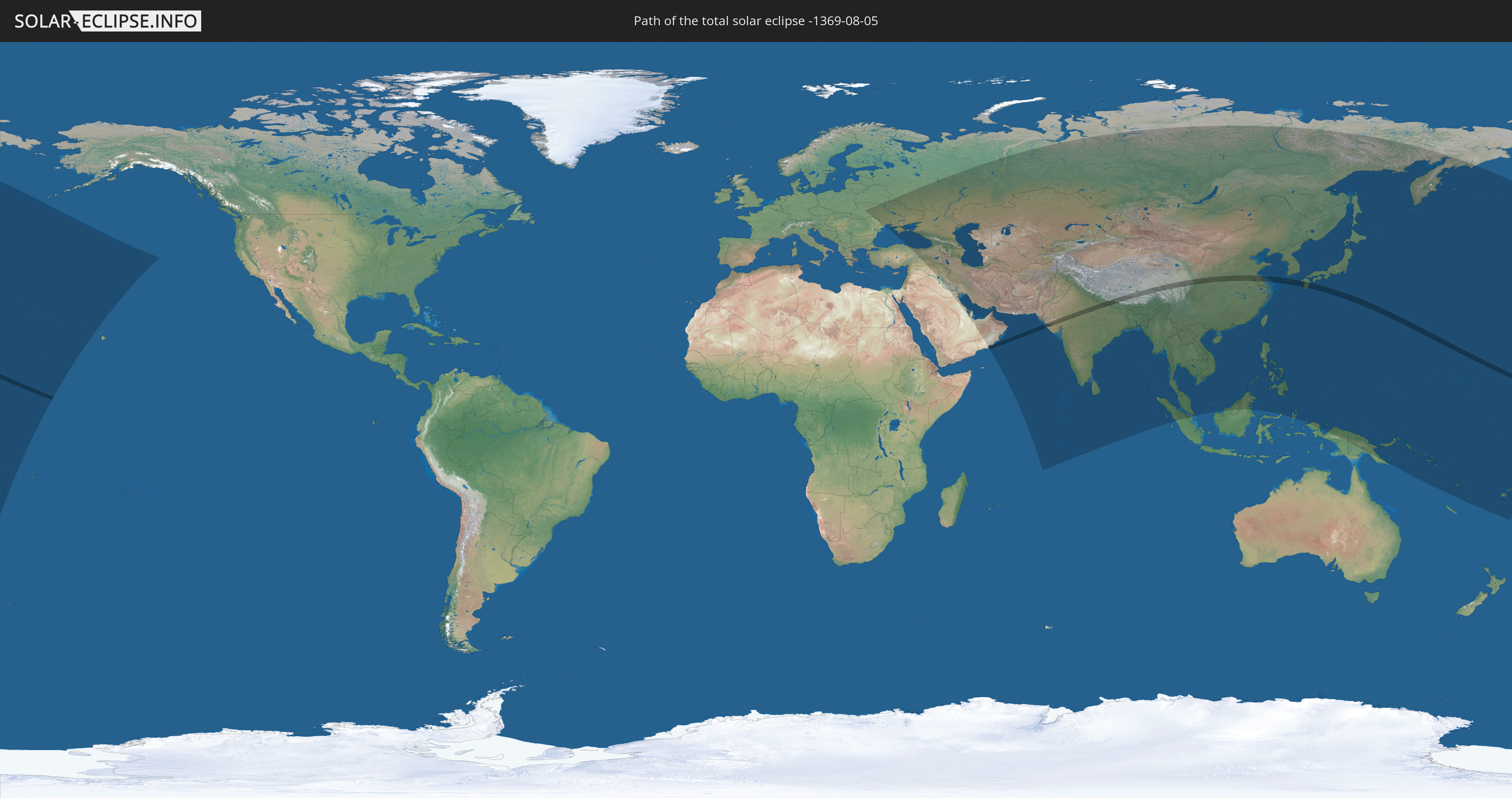
Die Sonnenfinsternis am 08/05/-1369 kann man in 64 Ländern als partielle Sonnenfinsternis beobachten.
Der Finsternispfad verläuft durch 6 Länder. Nur in diesen Ländern ist sie als total Sonnenfinsternis zu sehen.
In den folgenden Ländern ist die Sonnenfinsternis total zu sehen
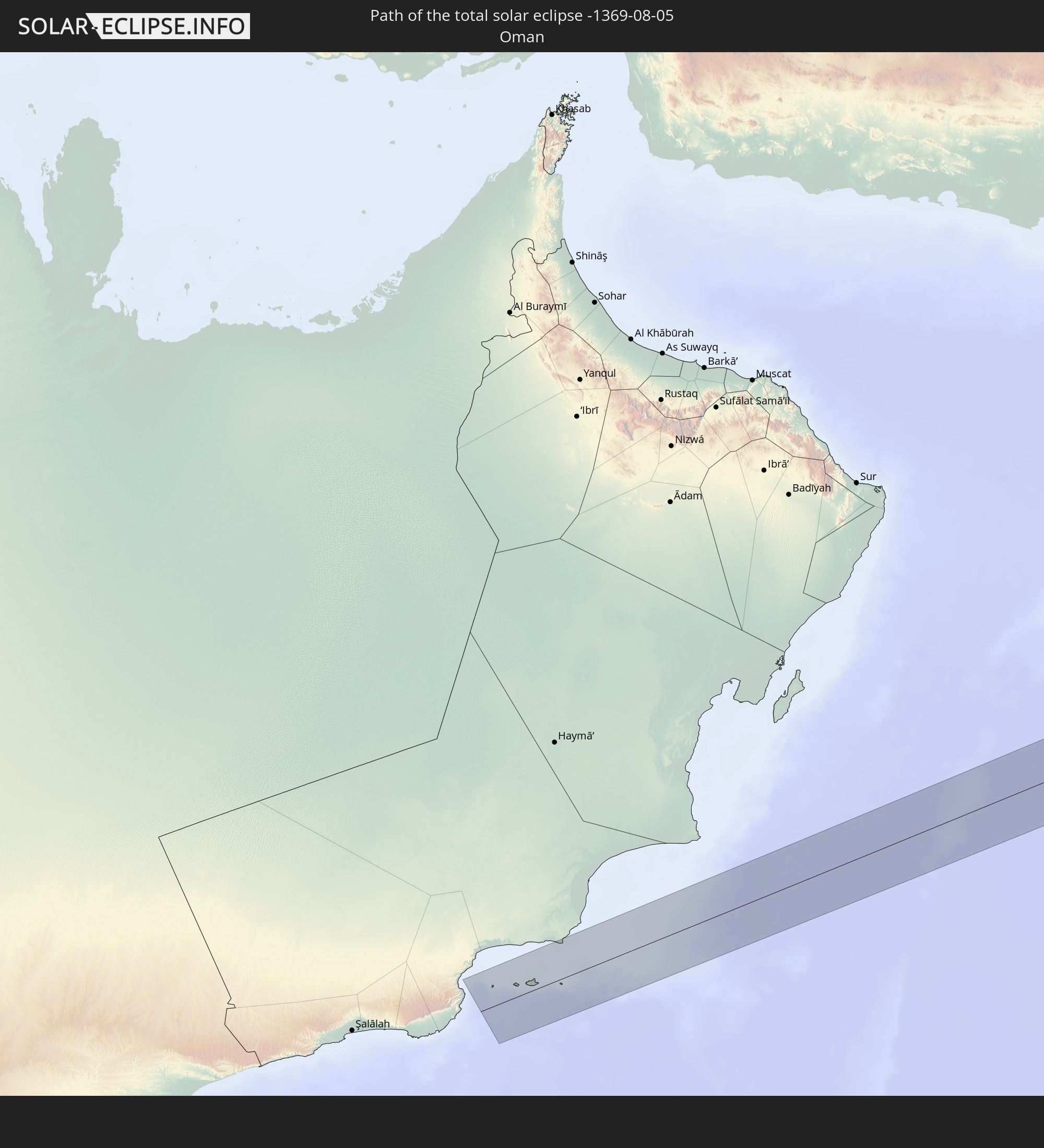 Oman
Oman
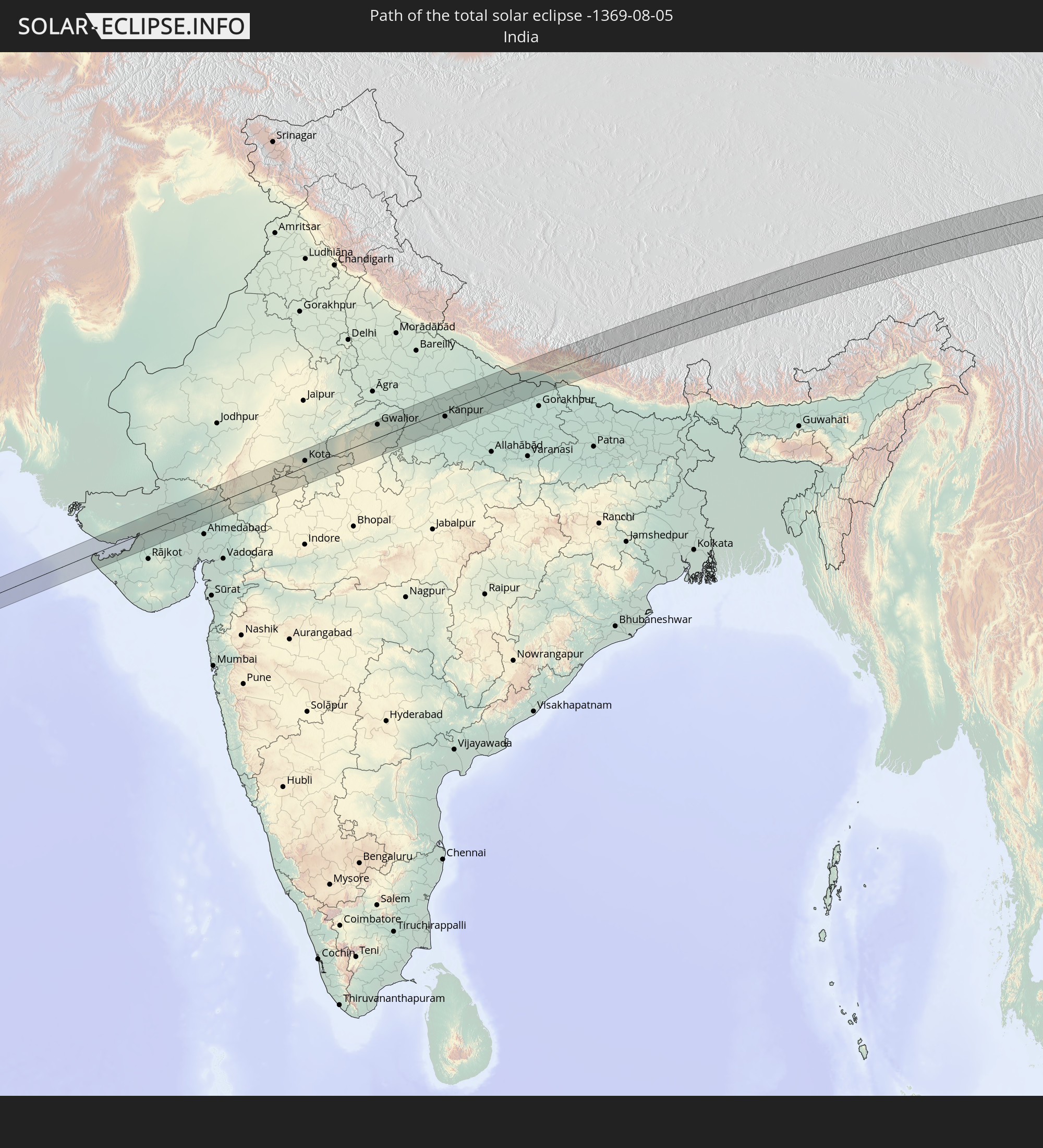 India
India
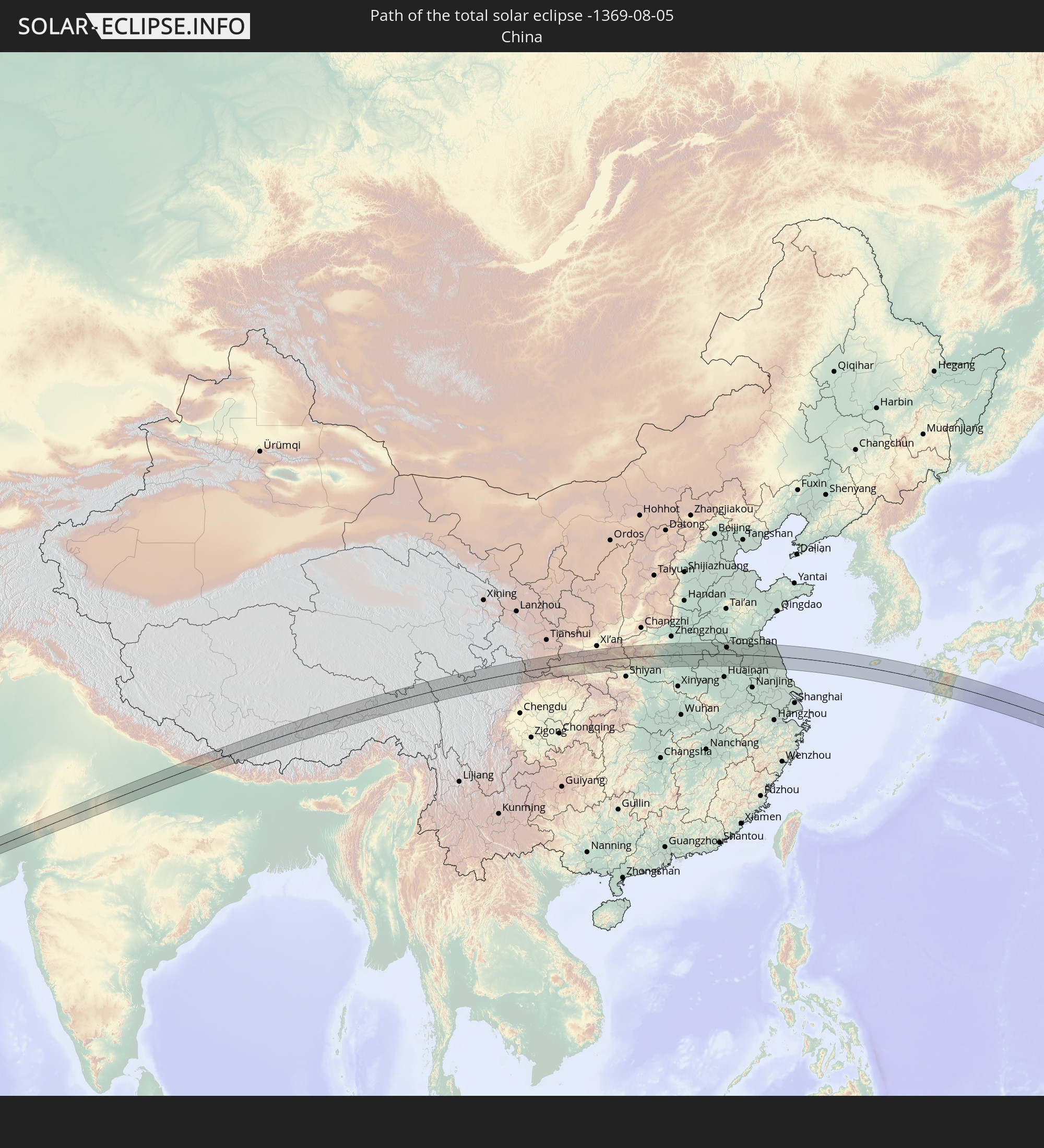 China
China
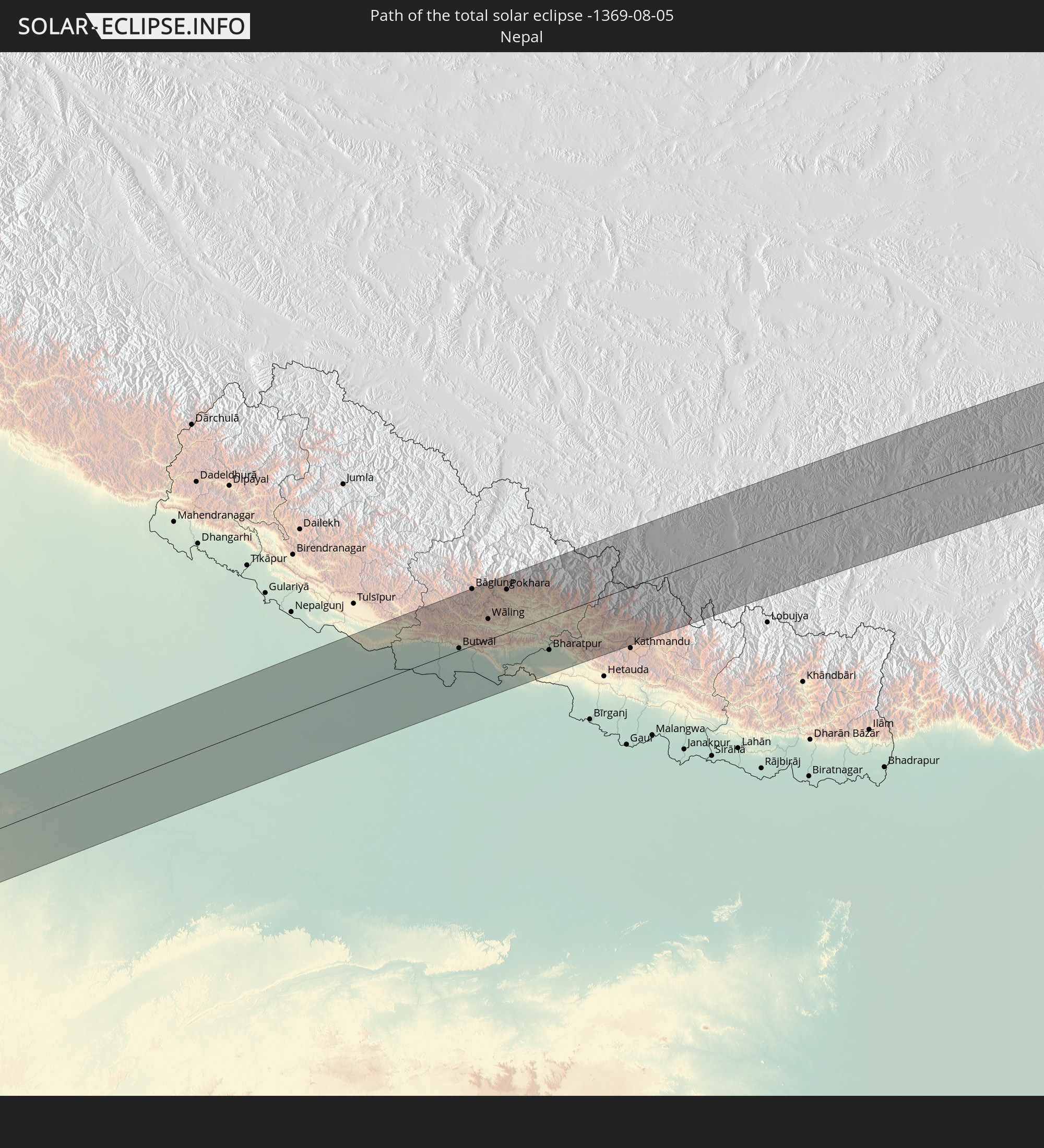 Nepal
Nepal
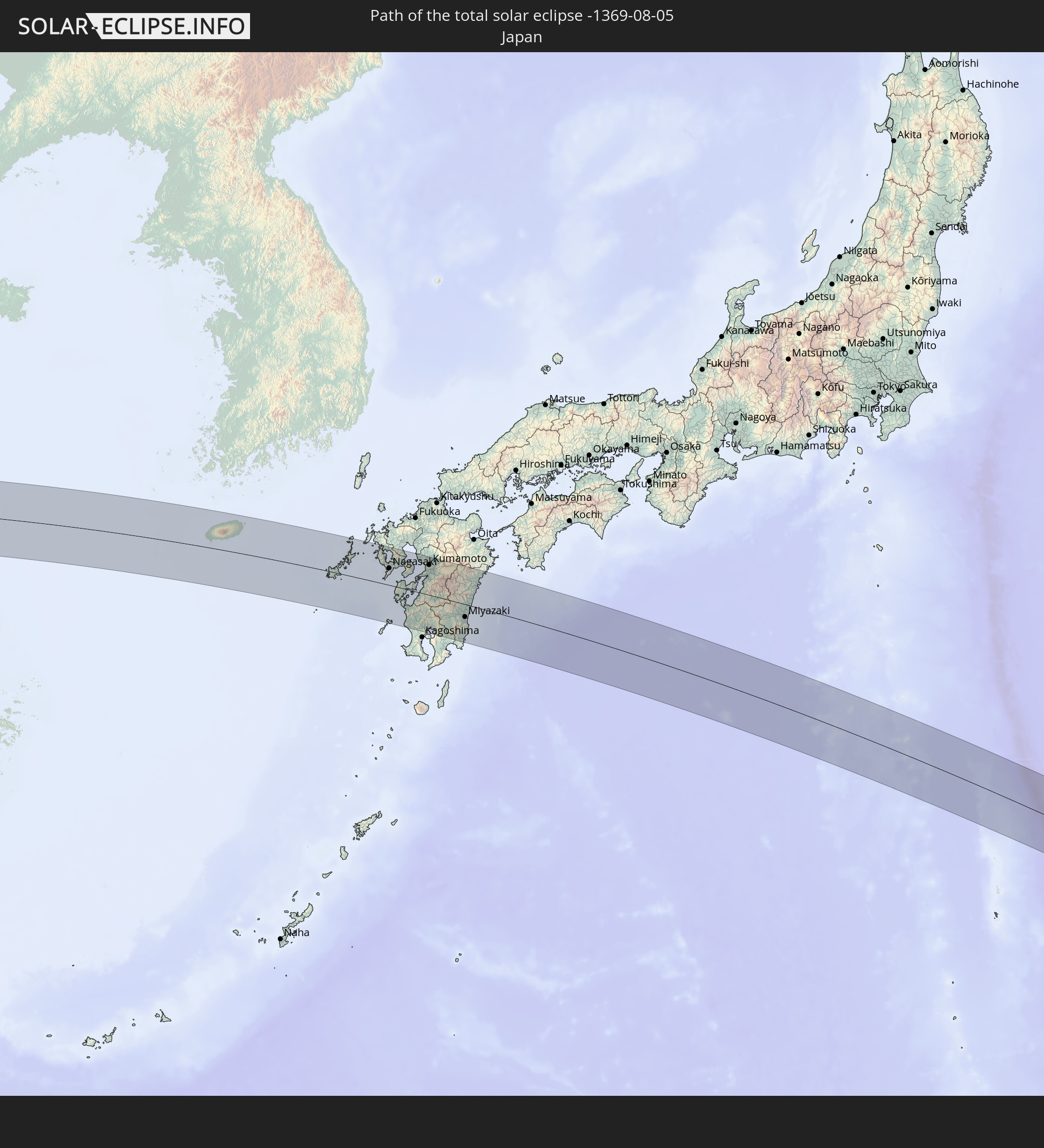 Japan
Japan
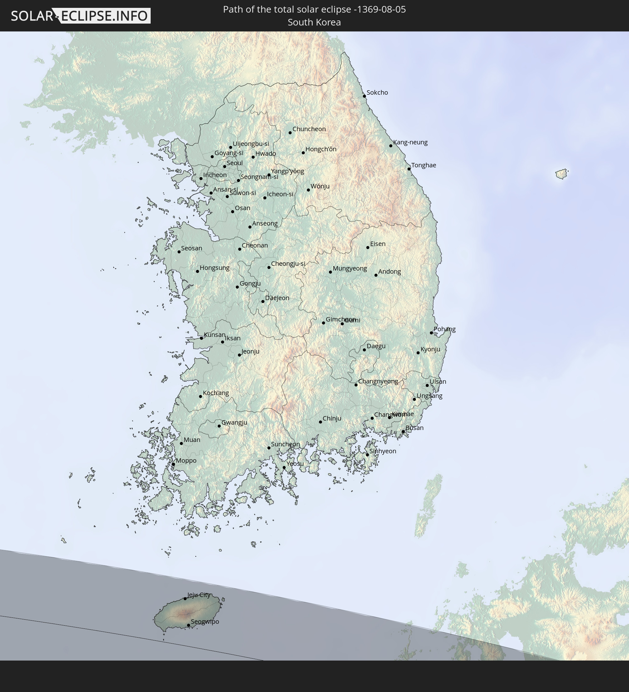 South Korea
In den folgenden Ländern ist die Sonnenfinsternis partiell zu sehen
 Russia
 Fiji
Fiji
 United States
 United States Minor Outlying Islands
 Wallis and Futuna
 Kiribati
 Ukraine
 Belarus
 Turkey
 Moldova
 Saudi Arabia
 Syria
Syria
 Iraq
Iraq
 Georgia
 Armenia
 Iran
Iran
 Azerbaijan
 Kazakhstan
 Kuwait
 Bahrain
 Qatar
Qatar
 United Arab Emirates
 Oman
Oman
 Turkmenistan
 Uzbekistan
 Afghanistan
 Pakistan
 Tajikistan
 India
India
 Kyrgyzstan
 British Indian Ocean Territory
 Maldives
 China
China
 Sri Lanka
 Nepal
Nepal
 Mongolia
 Bangladesh
 Bhutan
 Myanmar
 Indonesia
 Thailand
 Malaysia
 Laos
Laos
 Vietnam
 Cambodia
 Singapore
 Macau
Macau
 Hong Kong
 Brunei
 Taiwan
 Philippines
 Japan
Japan
 North Korea
 South Korea
 Palau
Palau
 Federated States of Micronesia
 Papua New Guinea
 Guam
Guam
 Northern Mariana Islands
 Solomon Islands
 Marshall Islands
 Vanuatu
 Nauru
Nauru
 Tuvalu
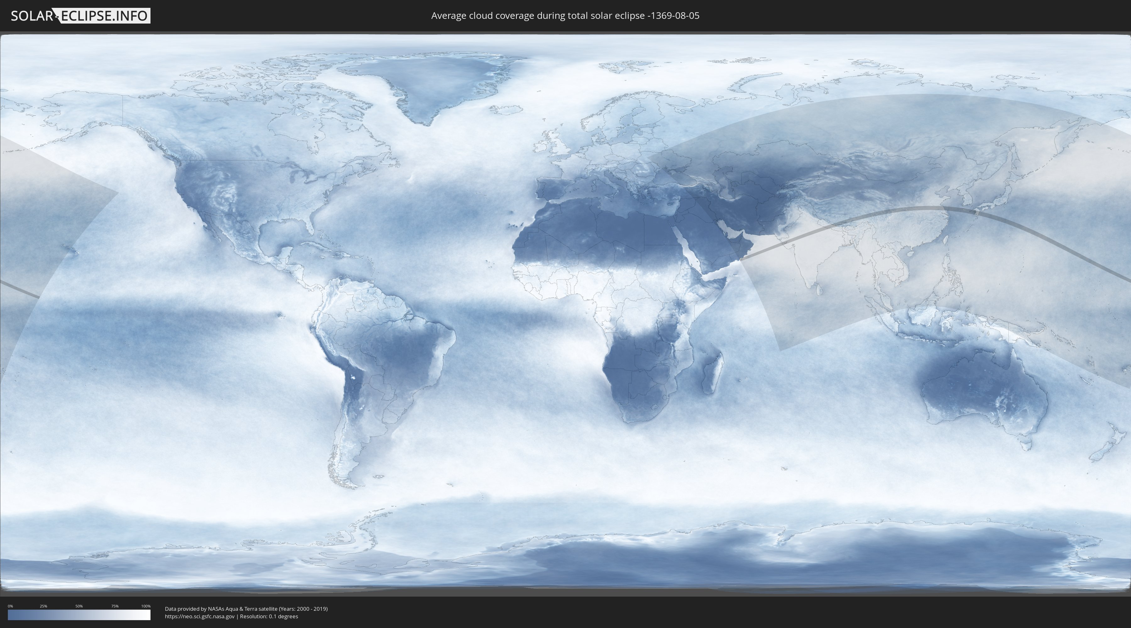
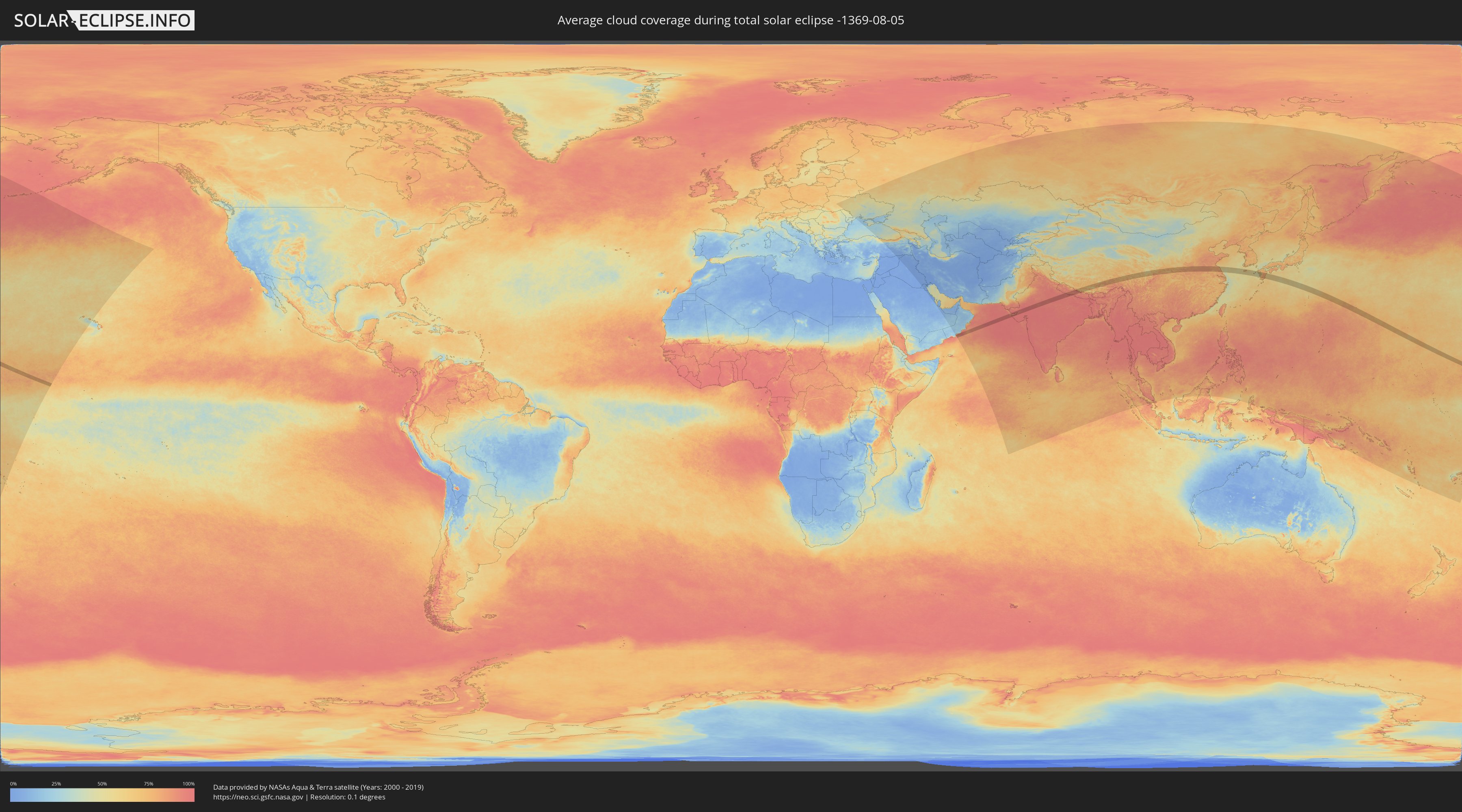
How will be the weather during the total solar eclipse on 08/05/-1369?
Where is the best place to see the total solar eclipse of 08/05/-1369?
The following maps show the average cloud coverage for the day of the total solar eclipse.
With the help of these maps, it is possible to find the place along the eclipse path, which has the best
chance of a cloudless sky.
Nevertheless, you should consider local circumstances and inform about the weather of your chosen
observation site.
The data is provided by NASAs satellites
AQUA and TERRA.
The cloud maps are averaged over a period of 19 years (2000 - 2019).
Detailed country maps
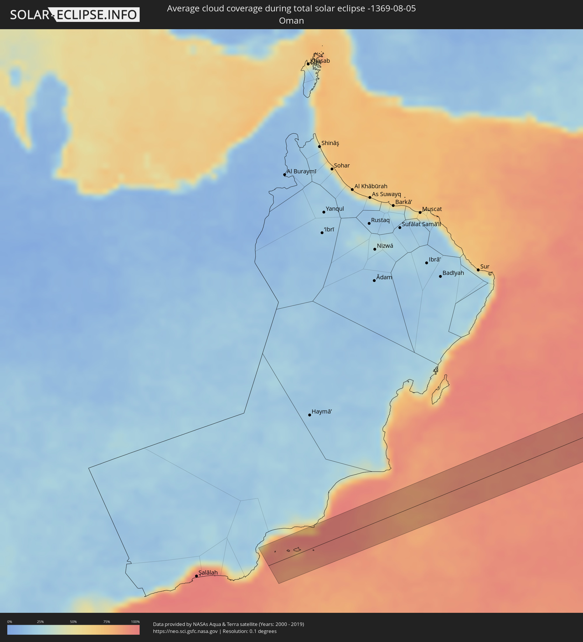 Oman
Oman
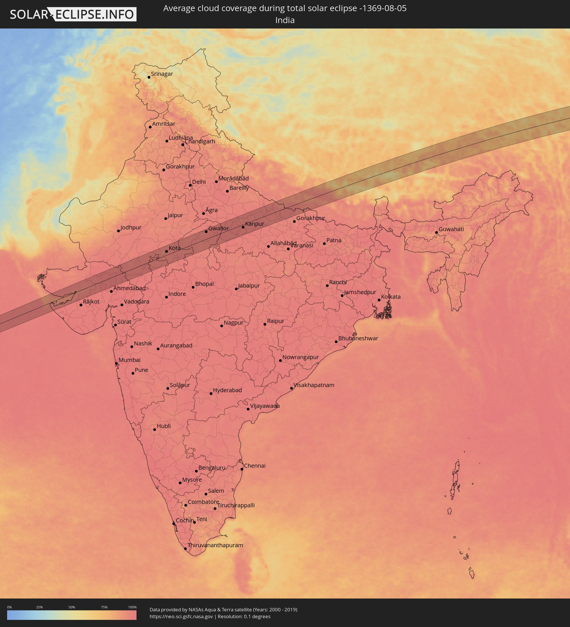 India
India
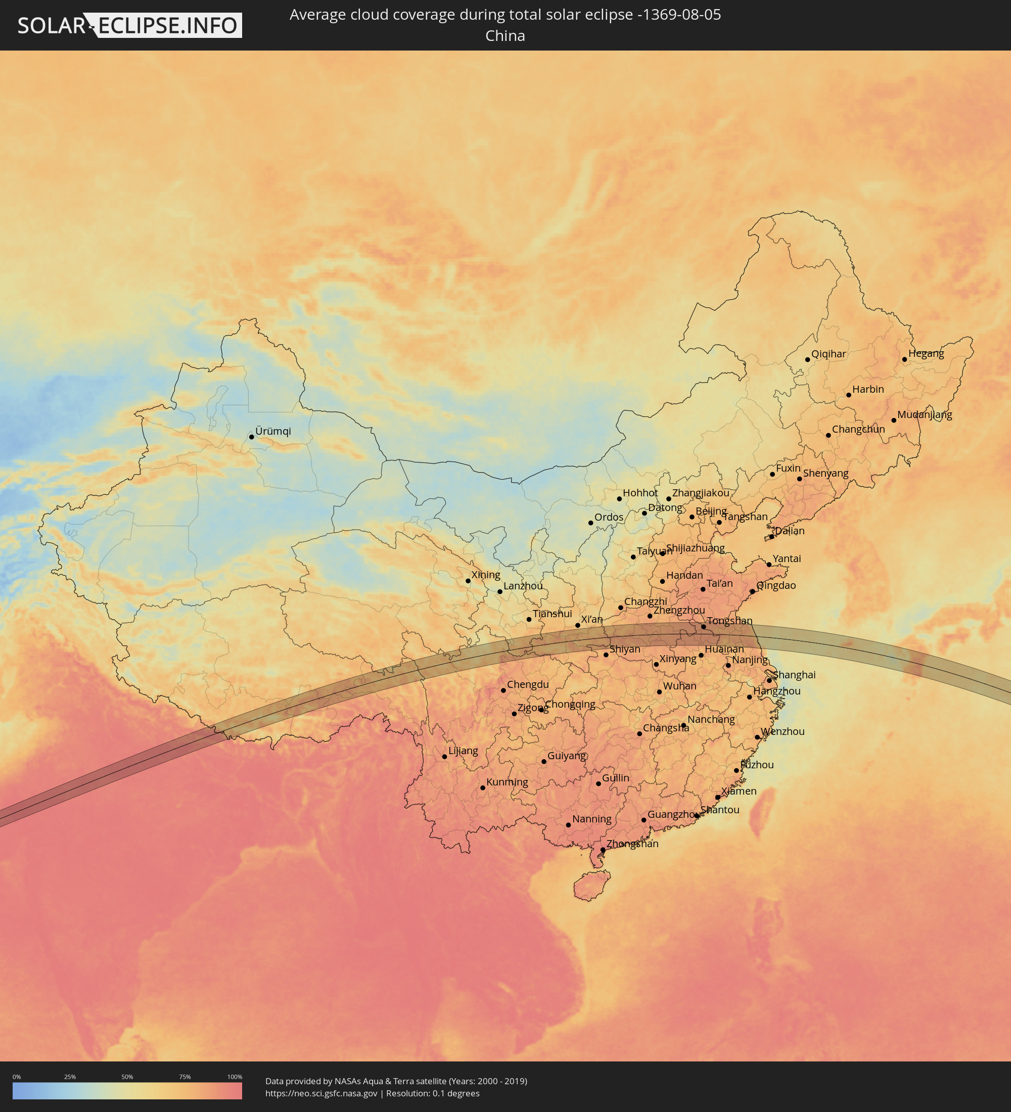 China
China
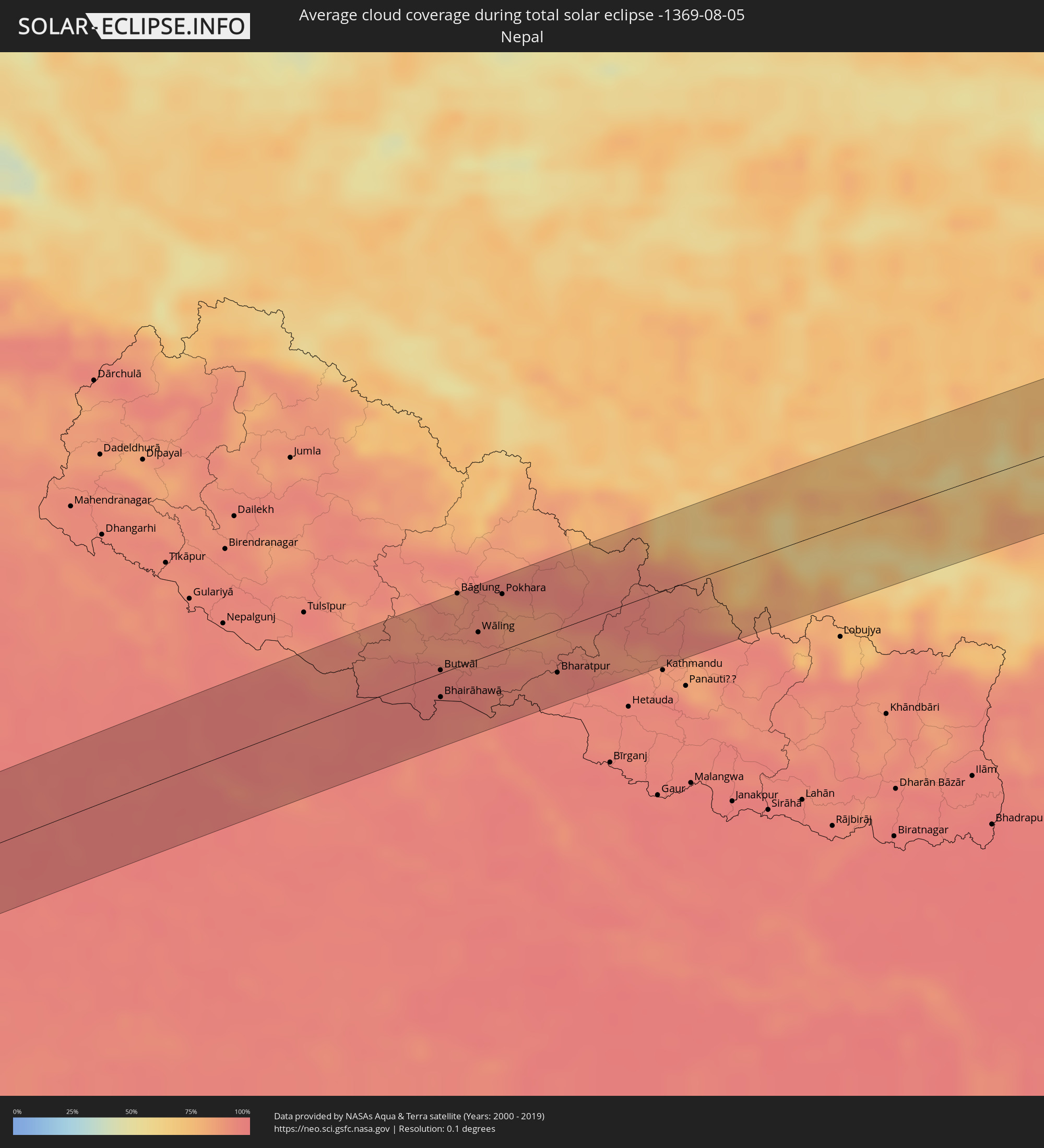 Nepal
Nepal
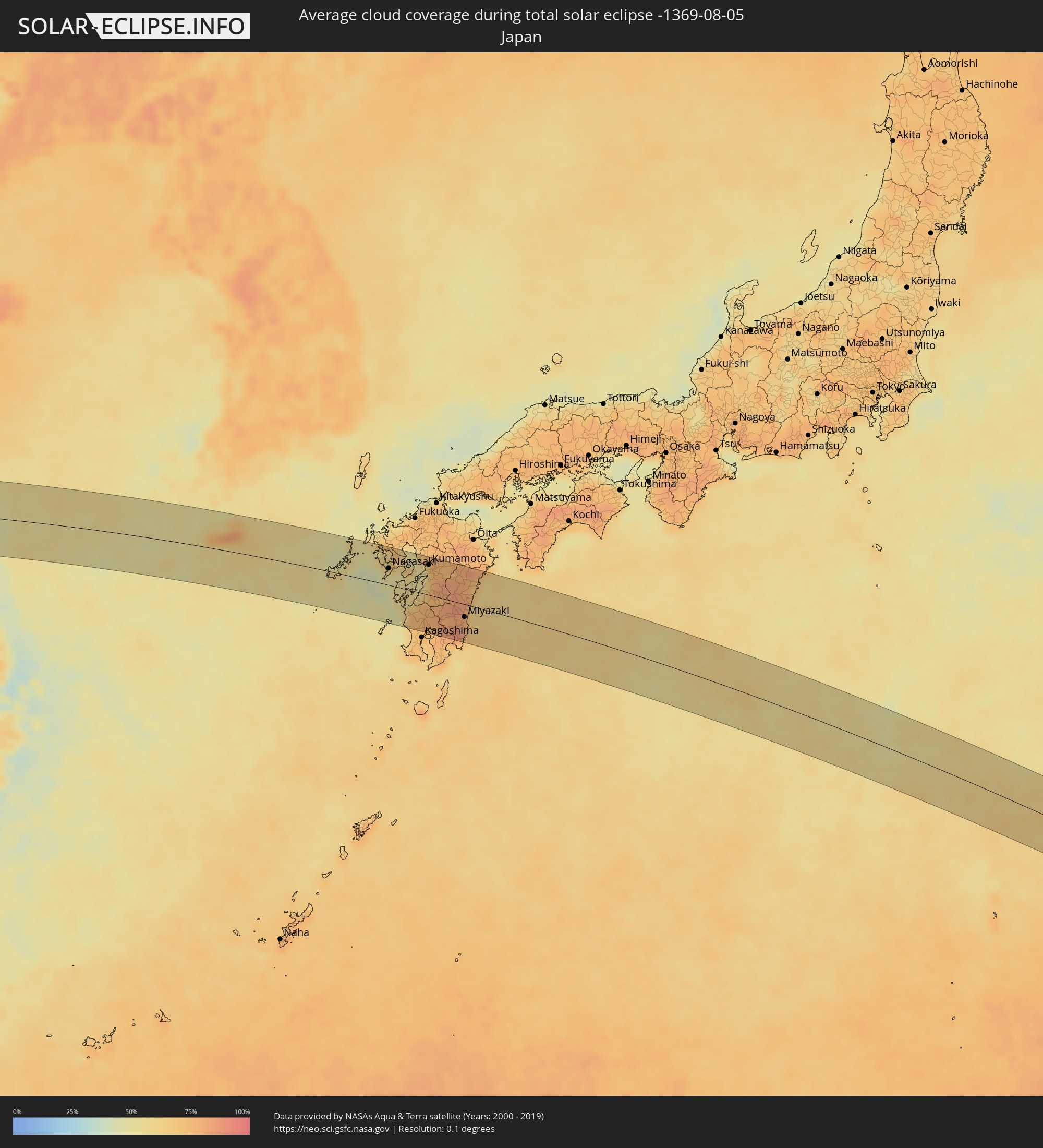 Japan
Japan
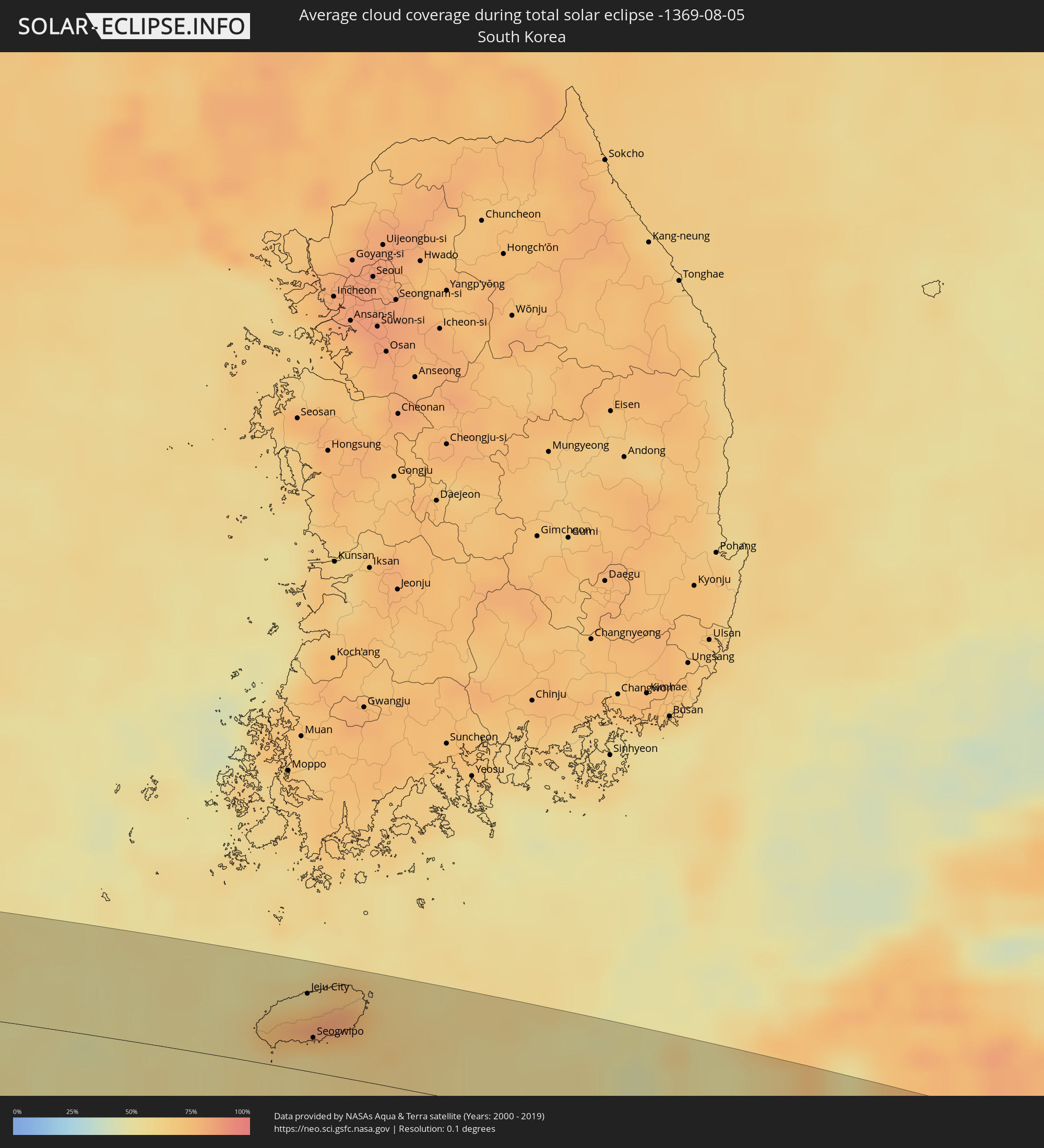 South Korea
Cities inside the path of the eclipse
The following table shows all locations with a population of more than 5,000 inside the eclipse path. Cities which have more than 100,000 inhabitants are marked bold. A click at the locations opens a detailed map.
| City | Type | Eclipse duration | Local time of max. eclipse | Distance to central line | Ø Cloud coverage |
|
Māndvi, Gujarat
|
total | - | 07:18:08 UTC+05:21 | 27 km | 90% |
|
Jāmnagar, Gujarat
|
total | - | 07:18:01 UTC+05:21 | 38 km | 97% |
|
Gāndhīdhām, Gujarat
|
total | - | 07:18:32 UTC+05:21 | 22 km | 96% |
|
Morbi, Gujarat
|
total | - | 07:18:31 UTC+05:21 | 33 km | 97% |
|
Dhrāngadhra, Gujarat
|
total | - | 07:18:50 UTC+05:21 | 40 km | 96% |
|
Pātan, Gujarat
|
total | - | 07:19:47 UTC+05:21 | 23 km | 98% |
|
Kadi, Gujarat
|
total | - | 07:19:23 UTC+05:21 | 42 km | 98% |
|
Unjha, Gujarat
|
total | - | 07:19:50 UTC+05:21 | 8 km | 98% |
|
Pālanpur, Gujarat
|
total | - | 07:20:10 UTC+05:21 | 44 km | 97% |
|
Visnagar, Gujarat
|
total | - | 07:19:48 UTC+05:21 | 9 km | 98% |
|
Himatnagar, Gujarat
|
total | - | 07:19:52 UTC+05:21 | 35 km | 98% |
|
Udaipur, Rajasthan
|
total | - | 07:21:00 UTC+05:21 | 37 km | 95% |
|
Dūngarpur, Rajasthan
|
total | - | 07:20:22 UTC+05:21 | 39 km | 97% |
|
Chittaurgarh, Rajasthan
|
total | - | 07:21:40 UTC+05:21 | 34 km | 96% |
|
Nīmbāhera, Rajasthan
|
total | - | 07:21:27 UTC+05:21 | 4 km | 97% |
|
Būndi, Rajasthan
|
total | - | 07:22:38 UTC+05:21 | 52 km | 95% |
|
Kota, Rajasthan
|
total | - | 07:22:30 UTC+05:21 | 18 km | 95% |
|
Bārān, Rajasthan
|
total | - | 07:22:46 UTC+05:21 | 16 km | 97% |
|
Sheopur, Madhya Pradesh
|
total | - | 07:23:23 UTC+05:21 | 36 km | 97% |
|
Shivpuri, Madhya Pradesh
|
total | - | 07:23:41 UTC+05:21 | 25 km | 94% |
|
Gwalior, Madhya Pradesh
|
total | - | 07:24:44 UTC+05:21 | 39 km | 95% |
|
Dabra, Madhya Pradesh
|
total | - | 07:24:30 UTC+05:21 | 3 km | 95% |
|
Gohadi, Madhya Pradesh
|
total | - | 07:25:06 UTC+05:21 | 50 km | 96% |
|
Datia, Madhya Pradesh
|
total | - | 07:24:23 UTC+05:21 | 29 km | 95% |
|
Bhind, Madhya Pradesh
|
total | - | 07:25:26 UTC+05:21 | 51 km | 96% |
|
Konch, Uttar Pradesh
|
total | - | 07:25:07 UTC+05:21 | 21 km | 96% |
|
Jālaun, Uttar Pradesh
|
total | - | 07:25:22 UTC+05:21 | 13 km | 97% |
|
Orai, Uttar Pradesh
|
total | - | 07:25:18 UTC+05:21 | 33 km | 96% |
|
Auraiya, Uttar Pradesh
|
total | - | 07:25:47 UTC+05:21 | 14 km | 97% |
|
Kālpi, Uttar Pradesh
|
total | - | 07:25:36 UTC+05:21 | 30 km | 96% |
|
Kanpur, Uttar Pradesh
|
total | - | 07:26:21 UTC+05:21 | 16 km | 96% |
|
Unnāo, Uttar Pradesh
|
total | - | 07:26:31 UTC+05:21 | 13 km | 97% |
|
Sandīla, Uttar Pradesh
|
total | - | 07:27:03 UTC+05:21 | 40 km | 96% |
|
Lucknow, Uttar Pradesh
|
total | - | 07:27:07 UTC+05:21 | 2 km | 96% |
|
Mahmudābād, Uttar Pradesh
|
total | - | 07:27:42 UTC+05:21 | 42 km | 96% |
|
Nawābganj, Uttar Pradesh
|
total | - | 07:27:24 UTC+05:21 | 2 km | 97% |
|
Bahraigh, Uttar Pradesh
|
total | - | 07:28:19 UTC+05:21 | 54 km | 96% |
|
Gondā City, Uttar Pradesh
|
total | - | 07:28:09 UTC+05:21 | 5 km | 95% |
|
Fyzābād, Uttar Pradesh
|
total | - | 07:27:58 UTC+05:21 | 49 km | 92% |
|
Balrāmpur, Uttar Pradesh
|
total | - | 07:28:38 UTC+05:21 | 18 km | 94% |
|
Butwāl, Western Region
|
total | - | 07:50:00 UTC+05:41 | 2 km | 96% |
|
Bhairāhawā, Western Region
|
total | - | 07:49:48 UTC+05:41 | 19 km | 95% |
|
Tānsen, Western Region
|
total | - | 07:50:15 UTC+05:41 | 16 km | 91% |
|
Bāglung, Western Region
|
total | - | 07:50:42 UTC+05:41 | 57 km | 87% |
|
Wāling, Western Region
|
total | - | 07:50:33 UTC+05:41 | 21 km | 91% |
|
Bhattarai Danda, Western Region
|
total | - | 07:50:36 UTC+05:41 | 5 km | 91% |
|
Pokhara, Western Region
|
total | - | 07:51:00 UTC+05:41 | 43 km | 90% |
|
Bharatpur, Central Region
|
total | - | 07:50:50 UTC+05:41 | 33 km | 92% |
|
Rikaze, Tibet Autonomous Region
|
total | - | 10:15:31 UTC+08:00 | 15 km | 50% |
|
Dêqên, Tibet Autonomous Region
|
total | - | 10:18:19 UTC+08:00 | 4 km | 77% |
|
Lhasa, Tibet Autonomous Region
|
total | - | 10:18:28 UTC+08:00 | 41 km | 63% |
|
Qamdo, Tibet Autonomous Region
|
total | - | 10:28:13 UTC+08:00 | 48 km | 67% |
|
Hanzhong, Shaanxi
|
total | - | 10:47:15 UTC+08:00 | 24 km | 64% |
|
Yuxia, Shaanxi
|
total | - | 10:51:05 UTC+08:00 | 66 km | 75% |
|
Yunyang, Henan
|
total | - | 10:59:32 UTC+08:00 | 34 km | 79% |
|
Pingdingshan, Henan
|
total | - | 11:00:57 UTC+08:00 | 5 km | 82% |
|
Yingchuan, Henan
|
total | - | 11:01:27 UTC+08:00 | 42 km | 83% |
|
Xiangcheng Chengguanzhen, Henan
|
total | - | 11:01:22 UTC+08:00 | 6 km | 82% |
|
Jiangguanchi, Henan
|
total | - | 11:02:12 UTC+08:00 | 37 km | 82% |
|
Luohe, Henan
|
total | - | 11:02:34 UTC+08:00 | 27 km | 86% |
|
Wacheng, Henan
|
total | - | 11:03:42 UTC+08:00 | 4 km | 83% |
|
Zhoukou, Henan
|
total | - | 11:03:56 UTC+08:00 | 21 km | 85% |
|
Huaidian, Henan
|
total | - | 11:04:49 UTC+08:00 | 44 km | 83% |
|
Xincheng, Henan
|
total | - | 11:05:12 UTC+08:00 | 22 km | 84% |
|
Jieshou, Anhui
|
total | - | 11:05:32 UTC+08:00 | 63 km | 82% |
|
Jishui, Henan
|
total | - | 11:05:44 UTC+08:00 | 11 km | 83% |
|
Shangqiu, Henan
|
total | - | 11:06:27 UTC+08:00 | 69 km | 86% |
|
Bozhou, Anhui
|
total | - | 11:06:37 UTC+08:00 | 5 km | 86% |
|
Mengcheng Chengguanzhen, Anhui
|
total | - | 11:08:23 UTC+08:00 | 63 km | 85% |
|
Tangzhai, Anhui
|
total | - | 11:08:36 UTC+08:00 | 67 km | 85% |
|
Suixi, Anhui
|
total | - | 11:08:57 UTC+08:00 | 6 km | 85% |
|
Huaibei, Anhui
|
total | - | 11:09:00 UTC+08:00 | 16 km | 84% |
|
Suzhou, Anhui
|
total | - | 11:09:24 UTC+08:00 | 22 km | 86% |
|
Tongshan, Jiangsu
|
total | - | 11:09:53 UTC+08:00 | 39 km | 85% |
|
Suicheng, Jiangsu
|
total | - | 11:11:41 UTC+08:00 | 9 km | 83% |
|
Pizhou, Jiangsu
|
total | - | 11:11:45 UTC+08:00 | 56 km | 81% |
|
Guiren, Jiangsu
|
total | - | 11:12:17 UTC+08:00 | 15 km | 84% |
|
Zhongxing, Jiangsu
|
total | - | 11:13:27 UTC+08:00 | 10 km | 80% |
|
Huai'an, Jiangsu
|
total | - | 11:14:16 UTC+08:00 | 21 km | 82% |
|
Gaogou, Jiangsu
|
total | - | 11:14:40 UTC+08:00 | 28 km | 78% |
|
Baoying, Jiangsu
|
total | - | 11:14:59 UTC+08:00 | 59 km | 74% |
|
Dongkan, Jiangsu
|
total | - | 11:16:13 UTC+08:00 | 29 km | 83% |
|
Qinnan, Jiangsu
|
total | - | 11:16:27 UTC+08:00 | 53 km | 79% |
|
Yancheng, Jiangsu
|
total | - | 11:17:03 UTC+08:00 | 40 km | 87% |
|
Hede, Jiangsu
|
total | - | 11:17:16 UTC+08:00 | 6 km | 78% |
|
Dazhong, Jiangsu
|
total | - | 11:17:48 UTC+08:00 | 56 km | 84% |
|
Gaigeturi, Jeju-do
|
total | - | 12:00:01 UTC+08:27 | 41 km | 67% |
|
Jeju City, Jeju-do
|
total | - | 12:00:30 UTC+08:27 | 49 km | 74% |
|
Seogwipo, Jeju-do
|
total | - | 12:00:43 UTC+08:27 | 22 km | 73% |
|
Fukuechō, Nagasaki
|
total | - | 12:38:48 UTC+09:00 | 3 km | 60% |
|
Togitsu, Nagasaki
|
total | - | 12:41:09 UTC+09:00 | 39 km | 62% |
|
Obita, Nagasaki
|
total | - | 12:41:15 UTC+09:00 | 38 km | 62% |
|
Nagasaki, Nagasaki
|
total | - | 12:41:18 UTC+09:00 | 31 km | 62% |
|
Ōmura, Nagasaki
|
total | - | 12:41:21 UTC+09:00 | 51 km | 62% |
|
Ushibukamachi, Kumamoto
|
total | - | 12:42:01 UTC+09:00 | 25 km | 54% |
|
Isahaya, Nagasaki
|
total | - | 12:41:37 UTC+09:00 | 44 km | 56% |
|
Hondomachi-hondo, Kumamoto
|
total | - | 12:42:11 UTC+09:00 | 6 km | 56% |
|
Akune, Kagoshima
|
total | - | 12:42:36 UTC+09:00 | 41 km | 63% |
|
Satsumasendai, Kagoshima
|
total | - | 12:42:59 UTC+09:00 | 61 km | 68% |
|
Izumi, Kagoshima
|
total | - | 12:42:57 UTC+09:00 | 30 km | 74% |
|
Shimabara, Nagasaki
|
total | - | 12:42:26 UTC+09:00 | 45 km | 57% |
|
Minamata, Kumamoto
|
total | - | 12:42:56 UTC+09:00 | 15 km | 68% |
|
Tamana, Kumamoto
|
total | - | 12:42:49 UTC+09:00 | 64 km | 63% |
|
Honmachi, Kumamoto
|
total | - | 12:43:13 UTC+09:00 | 21 km | 64% |
|
Ōkuchi-shinohara, Kagoshima
|
total | - | 12:43:36 UTC+09:00 | 26 km | 77% |
|
Matsubase, Kumamoto
|
total | - | 12:43:16 UTC+09:00 | 38 km | 69% |
|
Kajiki, Kagoshima
|
total | - | 12:43:58 UTC+09:00 | 61 km | 72% |
|
Uto, Kumamoto
|
total | - | 12:43:14 UTC+09:00 | 41 km | 69% |
|
Uekimachi-mōno, Kumamoto
|
total | - | 12:43:08 UTC+09:00 | 65 km | 73% |
|
Kumamoto, Kumamoto
|
total | - | 12:43:12 UTC+09:00 | 55 km | 71% |
|
Hamanoichi, Kagoshima
|
total | - | 12:44:08 UTC+09:00 | 61 km | 72% |
|
Hitoyoshi, Kumamoto
|
total | - | 12:43:48 UTC+09:00 | 7 km | 79% |
|
Kokubu-matsuki, Kagoshima
|
total | - | 12:44:12 UTC+09:00 | 59 km | 75% |
|
Ōzu, Kumamoto
|
total | - | 12:43:35 UTC+09:00 | 67 km | 76% |
|
Kobayashi, Miyazaki
|
total | - | 12:44:33 UTC+09:00 | 27 km | 79% |
|
Sueyoshichō-ninokata, Kagoshima
|
total | - | 12:44:53 UTC+09:00 | 62 km | 80% |
|
Miyakonojō, Miyazaki
|
total | - | 12:44:57 UTC+09:00 | 52 km | 83% |
|
Nichinan, Miyazaki
|
total | - | 12:45:47 UTC+09:00 | 59 km | 72% |
|
Tsuma, Miyazaki
|
total | - | 12:45:28 UTC+09:00 | 4 km | 77% |
|
Miyazaki, Miyazaki
|
total | - | 12:45:39 UTC+09:00 | 23 km | 78% |
|
Takanabe, Miyazaki
|
total | - | 12:45:41 UTC+09:00 | 2 km | 68% |
|
Nobeoka, Miyazaki
|
total | - | 12:45:43 UTC+09:00 | 54 km | 67% |