Annular solar eclipse of 09/04/-1399
| Day of week: | Wednesday |
| Maximum duration of eclipse: | 03m18s |
| Maximum width of eclipse path: | 168 km |
| Saros cycle: | 22 |
| Coverage: | 96.2% |
| Magnitude: | 0.9624 |
| Gamma: | 0.6 |
Wo kann man die Sonnenfinsternis vom 09/04/-1399 sehen?
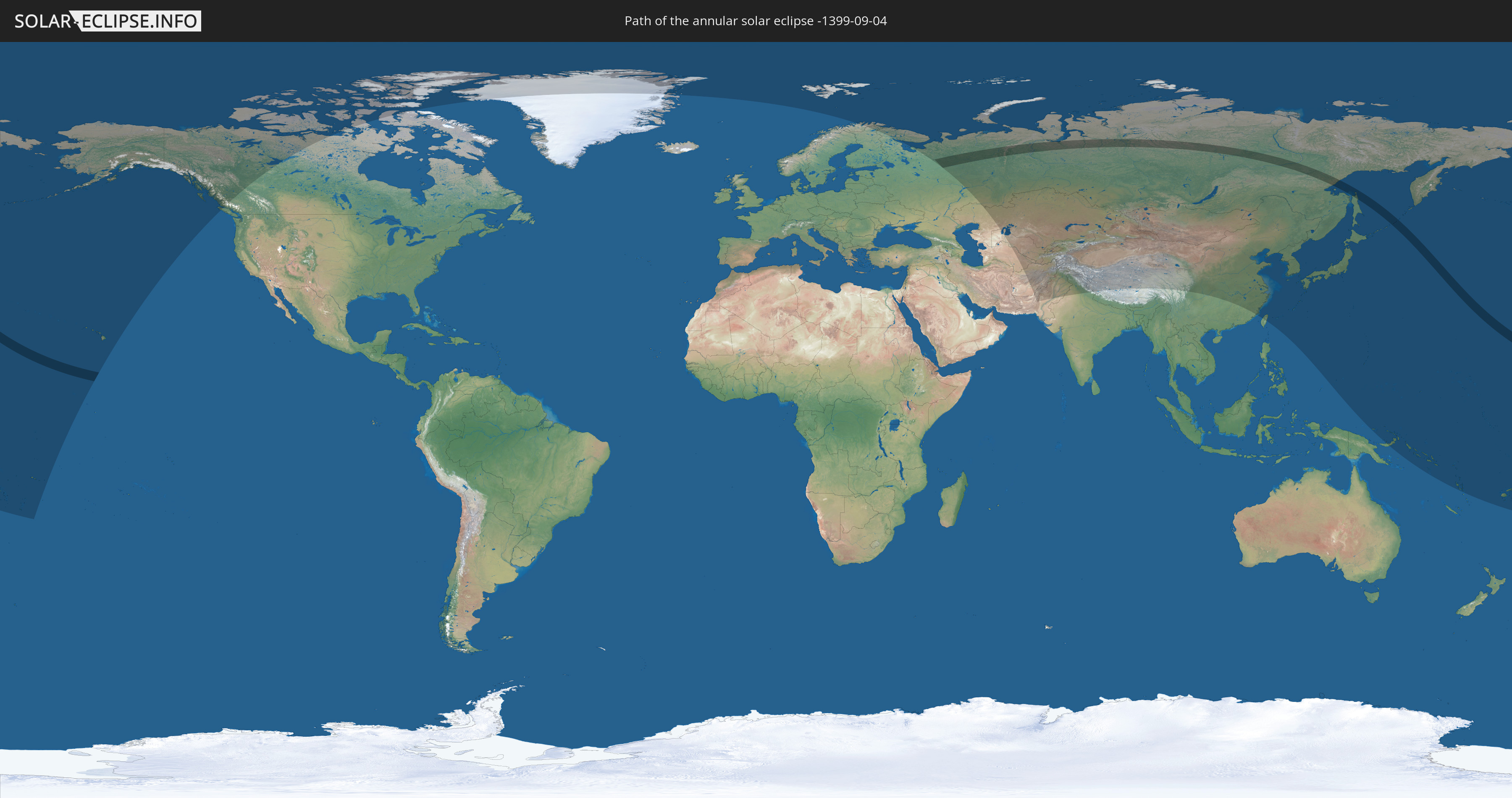
Die Sonnenfinsternis am 09/04/-1399 kann man in 38 Ländern als partielle Sonnenfinsternis beobachten.
Der Finsternispfad verläuft durch ein Land. Nur in diesem Land ist sie als annular Sonnenfinsternis zu sehen.
In den folgenden Ländern ist die Sonnenfinsternis annular zu sehen
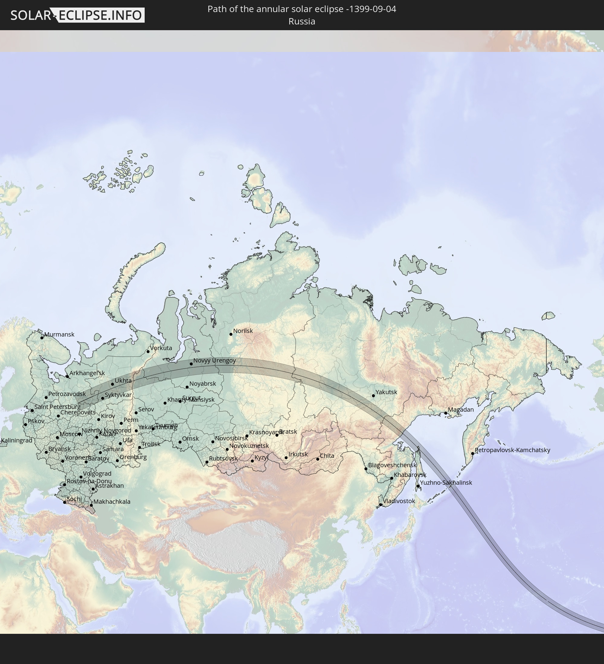 Russia
In den folgenden Ländern ist die Sonnenfinsternis partiell zu sehen
 Russia
 Fiji
Fiji
 United States
 United States Minor Outlying Islands
 Wallis and Futuna
 Tonga
Tonga
 Kiribati
 Samoa
Samoa
 Tokelau
 American Samoa
 Canada
 Greenland
 Svalbard and Jan Mayen
 Norway
 Finland
 Kazakhstan
 Turkmenistan
 Uzbekistan
 Afghanistan
 Pakistan
 Tajikistan
 India
India
 Kyrgyzstan
 China
China
 Mongolia
 Taiwan
 Japan
Japan
 North Korea
 South Korea
 Federated States of Micronesia
 Papua New Guinea
 Guam
Guam
 Northern Mariana Islands
 Solomon Islands
 Marshall Islands
 Vanuatu
 Nauru
Nauru
 Tuvalu
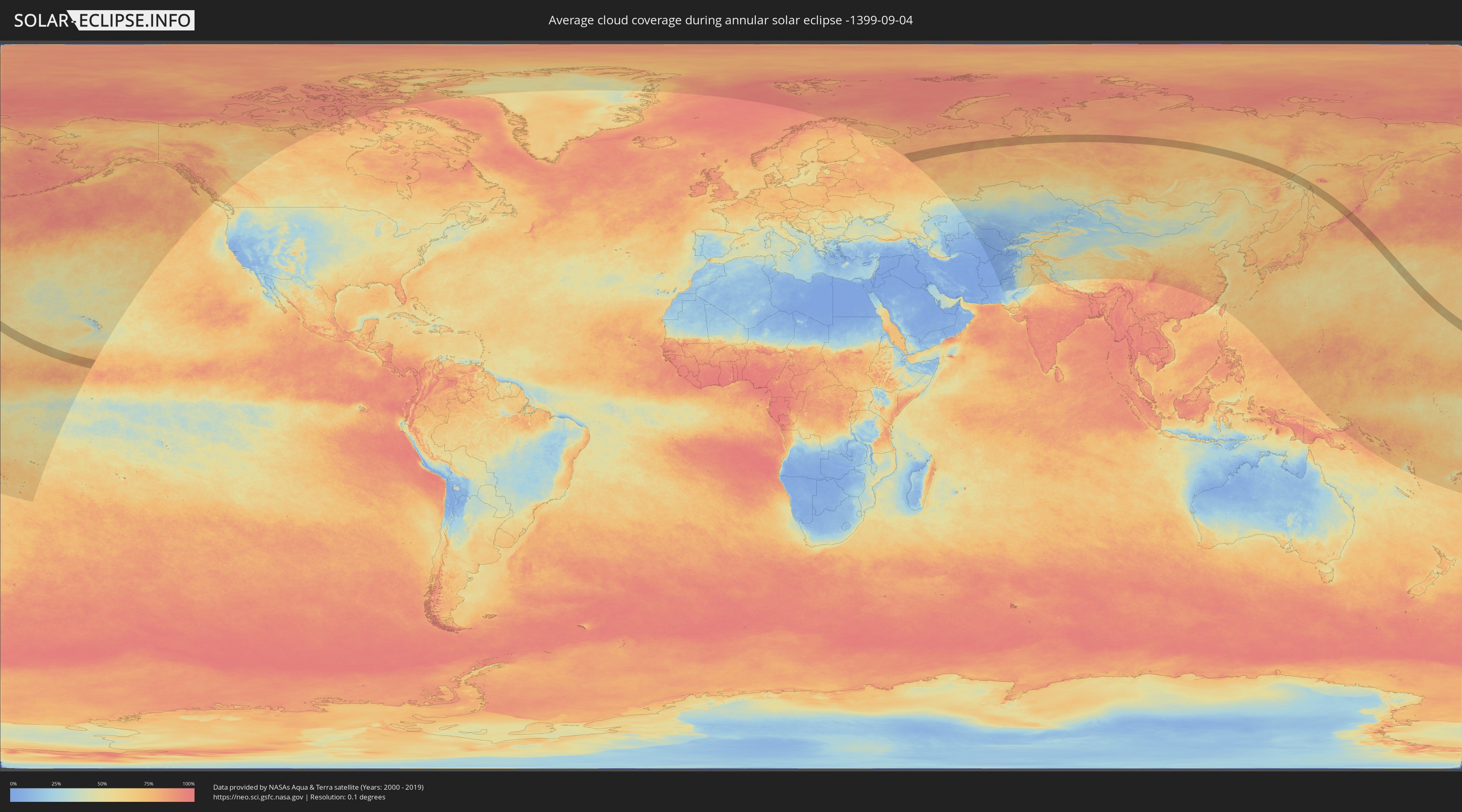
How will be the weather during the annular solar eclipse on 09/04/-1399?
Where is the best place to see the annular solar eclipse of 09/04/-1399?
The following maps show the average cloud coverage for the day of the annular solar eclipse.
With the help of these maps, it is possible to find the place along the eclipse path, which has the best
chance of a cloudless sky.
Nevertheless, you should consider local circumstances and inform about the weather of your chosen
observation site.
The data is provided by NASAs satellites
AQUA and TERRA.
The cloud maps are averaged over a period of 19 years (2000 - 2019).

Detailed country maps
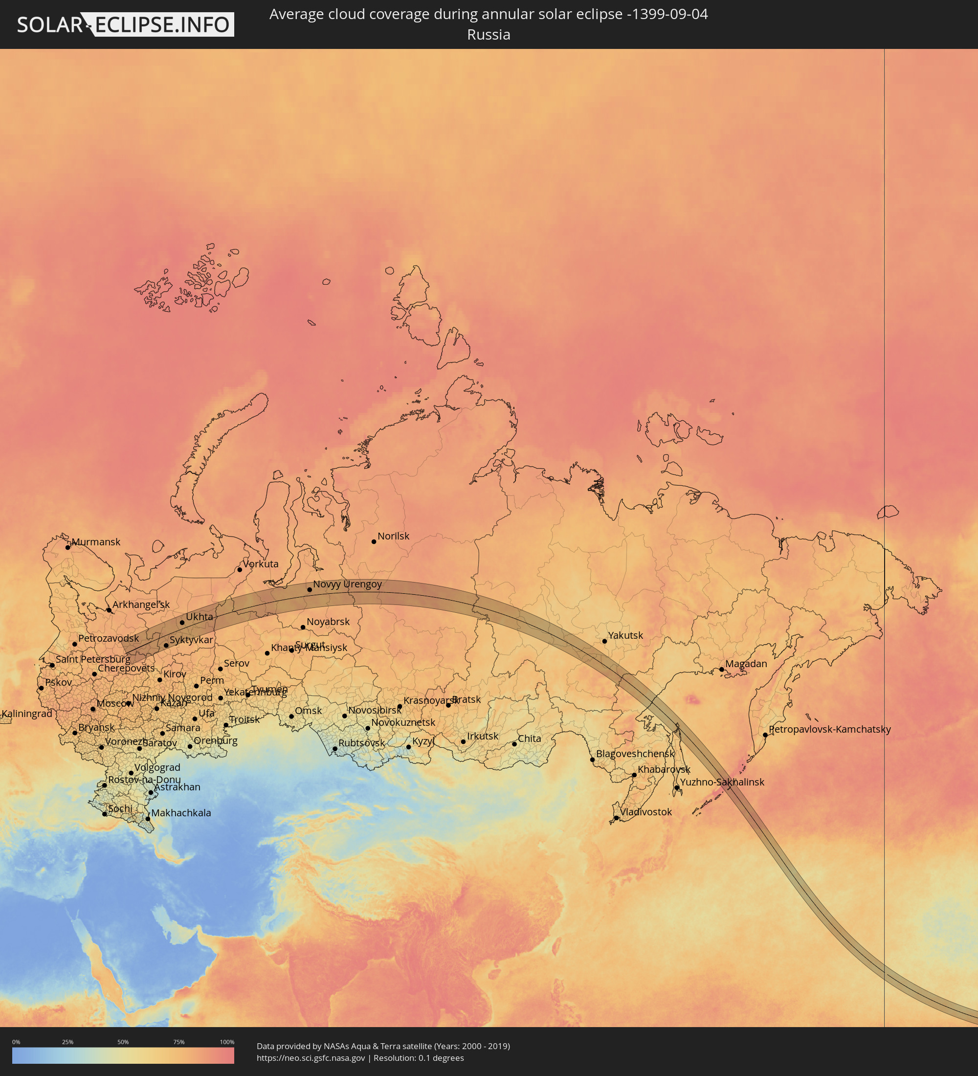 Russia
Cities inside the path of the eclipse
The following table shows all locations with a population of more than 5,000 inside the eclipse path. Cities which have more than 100,000 inhabitants are marked bold. A click at the locations opens a detailed map.
| City | Type | Eclipse duration | Local time of max. eclipse | Distance to central line | Ø Cloud coverage |
|
Shenkursk, Arkhangelskaya
|
annular | - | 04:09:04 UTC+02:30 | 118 km | 80% |
|
Mirnyy, Arkhangelskaya
|
annular | - | 04:07:47 UTC+02:30 | 3 km | 79% |
|
Velikiy Ustyug, Vologda
|
annular | - | 04:06:43 UTC+02:30 | 95 km | 76% |
|
Krasavino, Vologda
|
annular | - | 04:06:54 UTC+02:30 | 79 km | 75% |
|
Kotlas, Arkhangelskaya
|
annular | - | 04:07:13 UTC+02:30 | 52 km | 76% |
|
Vychegodskiy, Arkhangelskaya
|
annular | - | 04:07:09 UTC+02:30 | 59 km | 76% |
|
Koryazhma, Arkhangelskaya
|
annular | - | 04:07:10 UTC+02:30 | 58 km | 75% |
|
Zheshart, Komi Republic
|
annular | - | 04:07:37 UTC+02:30 | 31 km | 78% |
|
Mikun’, Komi Republic
|
annular | - | 04:07:52 UTC+02:30 | 12 km | 78% |
|
Ezhva, Komi Republic
|
annular | - | 04:07:07 UTC+02:30 | 81 km | 78% |
|
Syktyvkar, Komi Republic
|
annular | - | 04:06:56 UTC+02:30 | 97 km | 78% |
|
Yemva, Komi Republic
|
annular | - | 04:08:02 UTC+02:30 | 4 km | 78% |
|
Vodnyy, Komi Republic
|
annular | - | 04:08:52 UTC+02:30 | 43 km | 77% |
|
Yarega, Komi Republic
|
annular | - | 04:08:45 UTC+02:30 | 33 km | 78% |
|
Ukhta, Komi Republic
|
annular | - | 04:08:55 UTC+02:30 | 44 km | 79% |
|
Sosnogorsk, Komi Republic
|
annular | - | 04:08:56 UTC+02:30 | 45 km | 79% |
|
Nizhniy Odes, Komi Republic
|
annular | - | 04:08:54 UTC+02:30 | 32 km | 80% |
|
Troitsko-Pechorsk, Komi Republic
|
annular | - | 04:07:37 UTC+02:30 | 89 km | 74% |
|
Vuktyl, Komi Republic
|
annular | - | 04:09:01 UTC+02:30 | 13 km | 78% |
|
Berëzovo, Khanty-Mansiyskiy Avtonomnyy Okrug
|
annular | - | 05:41:28 UTC+04:02 | 88 km | 73% |
|
Nadym, Yamalo-Nenetskiy Avtonomnyy Okrug
|
annular | - | 05:44:30 UTC+04:02 | 9 km | 78% |
|
Pangody, Yamalo-Nenetskiy Avtonomnyy Okrug
|
annular | - | 05:45:18 UTC+04:02 | 29 km | 80% |
|
Novyy Urengoy, Yamalo-Nenetskiy Avtonomnyy Okrug
|
annular | - | 05:46:05 UTC+04:02 | 41 km | 78% |
|
Tarko-Sale, Yamalo-Nenetskiy Avtonomnyy Okrug
|
annular | - | 05:44:51 UTC+04:02 | 94 km | 77% |
|
Urengoy, Yamalo-Nenetskiy Avtonomnyy Okrug
|
annular | - | 05:46:21 UTC+04:02 | 19 km | 77% |
|
Nyurba, Sakha
|
annular | - | 10:43:34 UTC+08:38 | 25 km | 66% |
|
Verkhnevilyuysk, Sakha
|
annular | - | 10:45:18 UTC+08:38 | 84 km | 66% |
|
Okha, Sakhalin
|
annular | - | 12:51:33 UTC+10:14 | 23 km | 67% |