Annular solar eclipse of 05/01/-1420
| Day of week: | Saturday |
| Maximum duration of eclipse: | 04m05s |
| Maximum width of eclipse path: | 134 km |
| Saros cycle: | 25 |
| Coverage: | 96.3% |
| Magnitude: | 0.9631 |
| Gamma: | -0.0302 |
Wo kann man die Sonnenfinsternis vom 05/01/-1420 sehen?
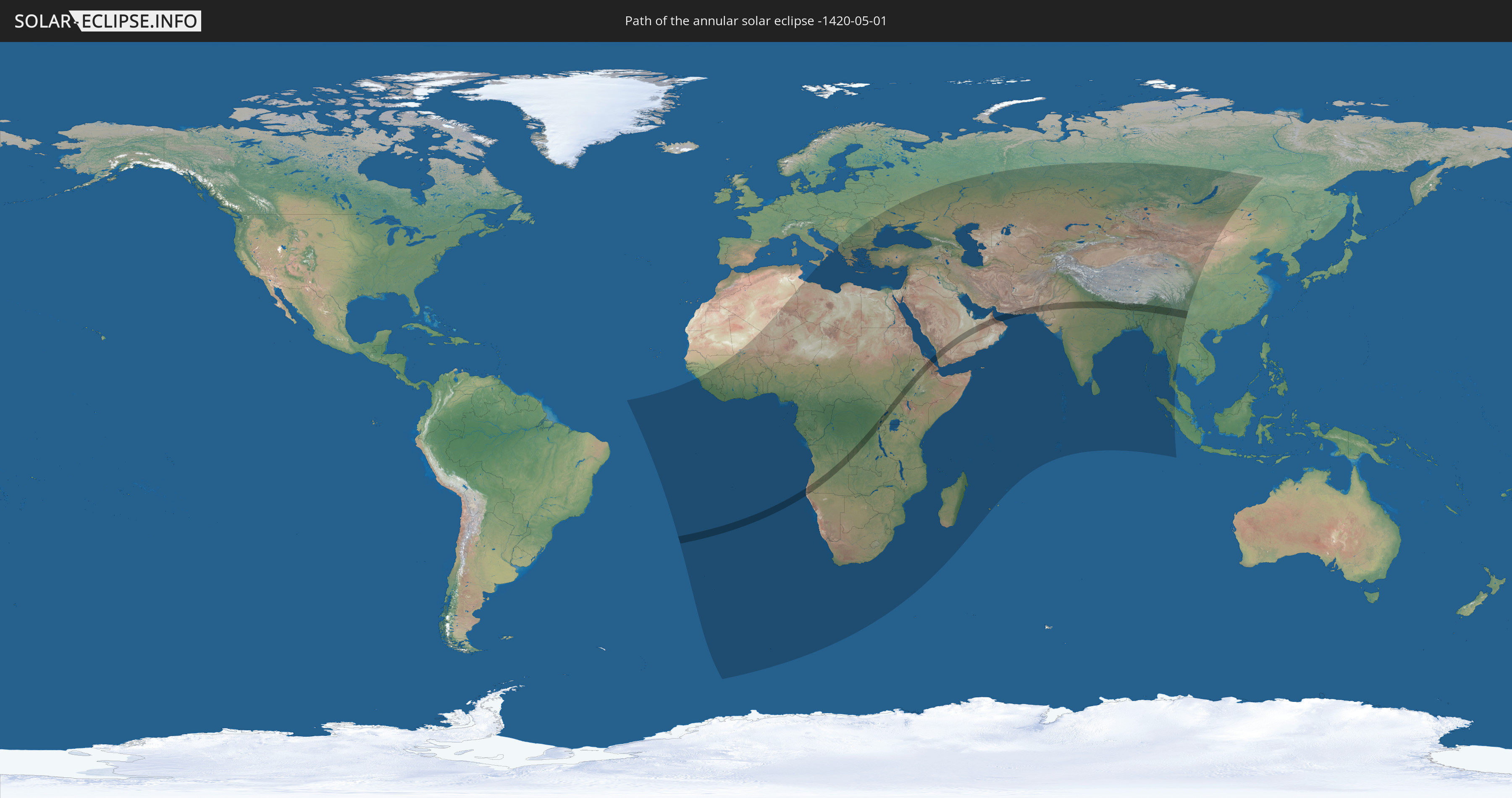
Die Sonnenfinsternis am 05/01/-1420 kann man in 103 Ländern als partielle Sonnenfinsternis beobachten.
Der Finsternispfad verläuft durch 21 Länder. Nur in diesen Ländern ist sie als annular Sonnenfinsternis zu sehen.
In den folgenden Ländern ist die Sonnenfinsternis annular zu sehen
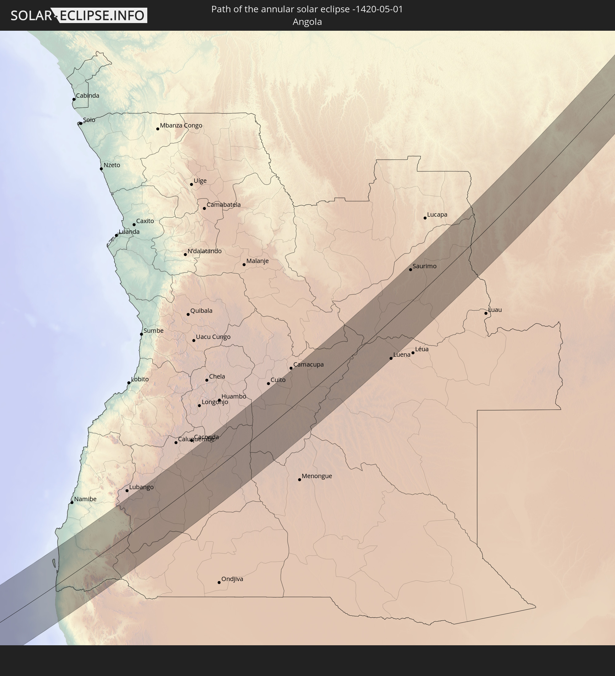 Angola
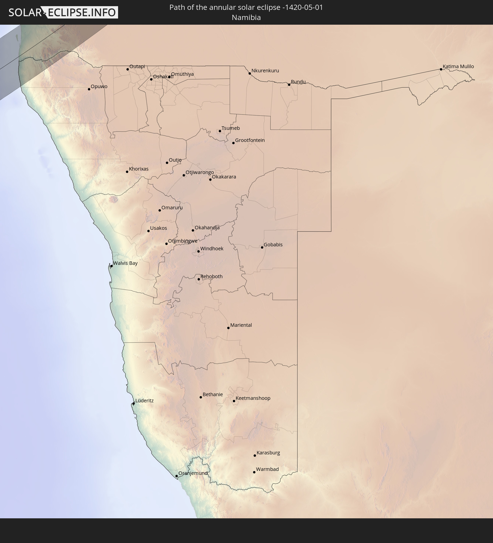 Namibia
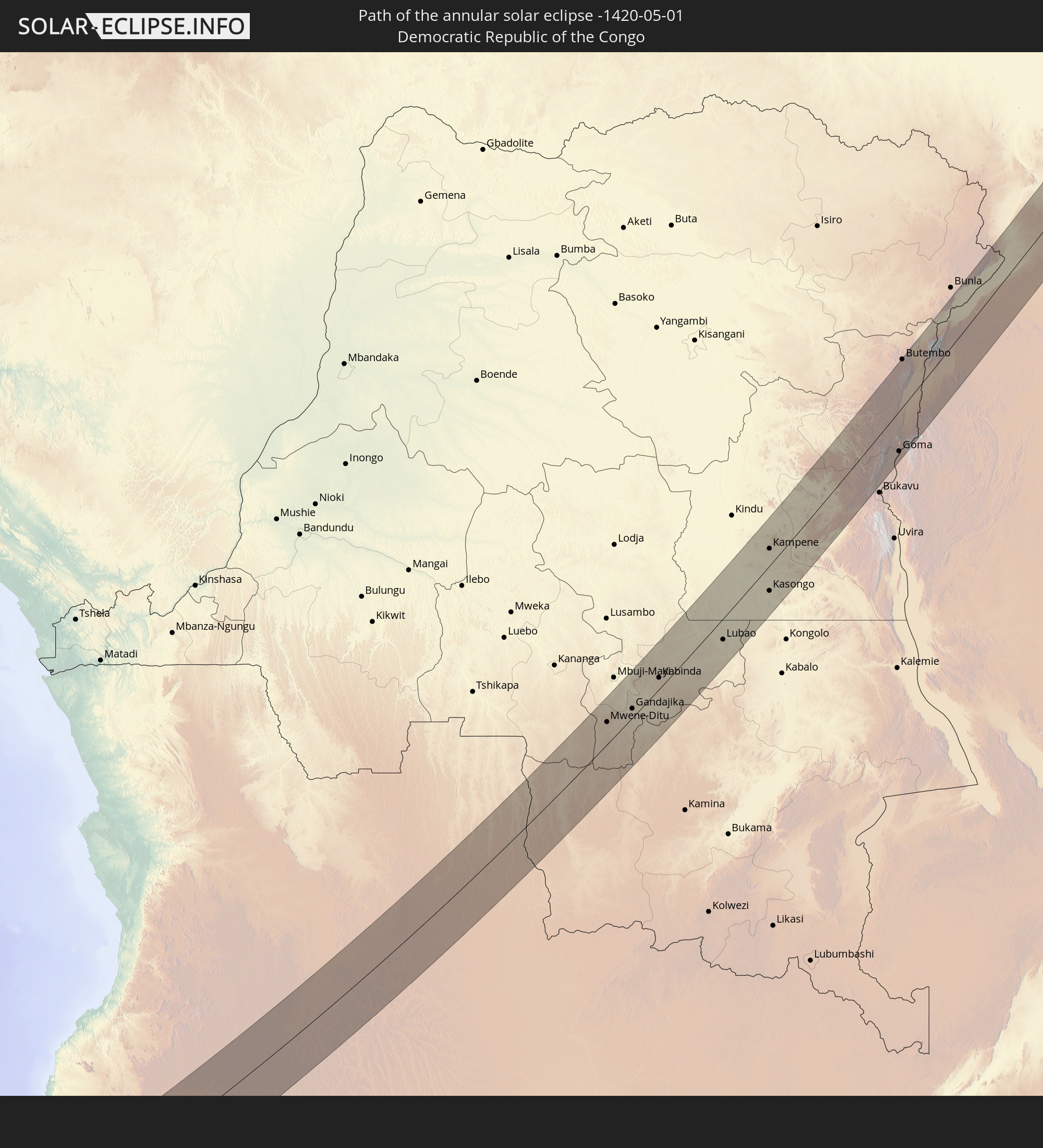 Democratic Republic of the Congo
 South Sudan
 Rwanda
 Uganda
 Ethiopia
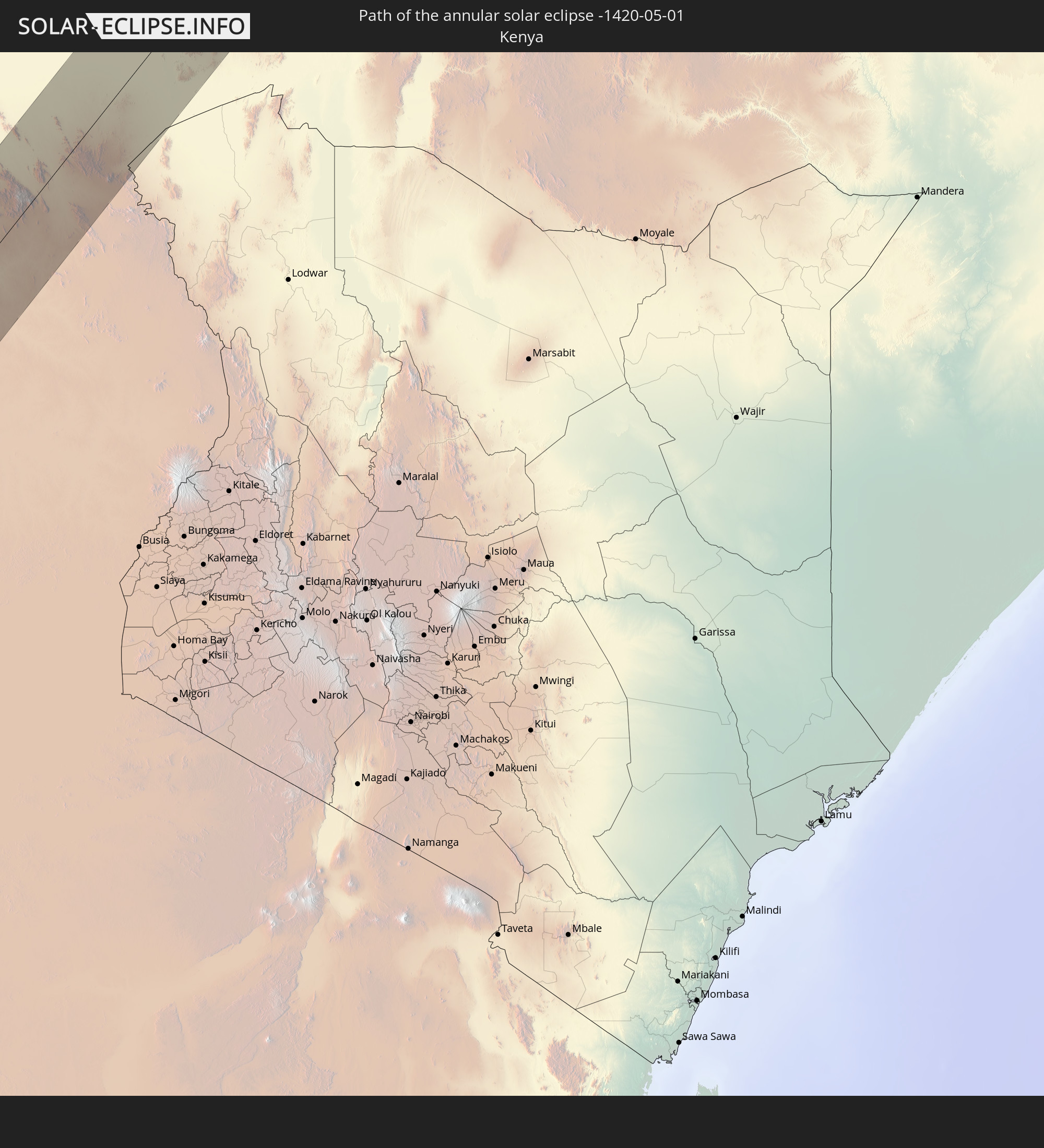 Kenya
Kenya
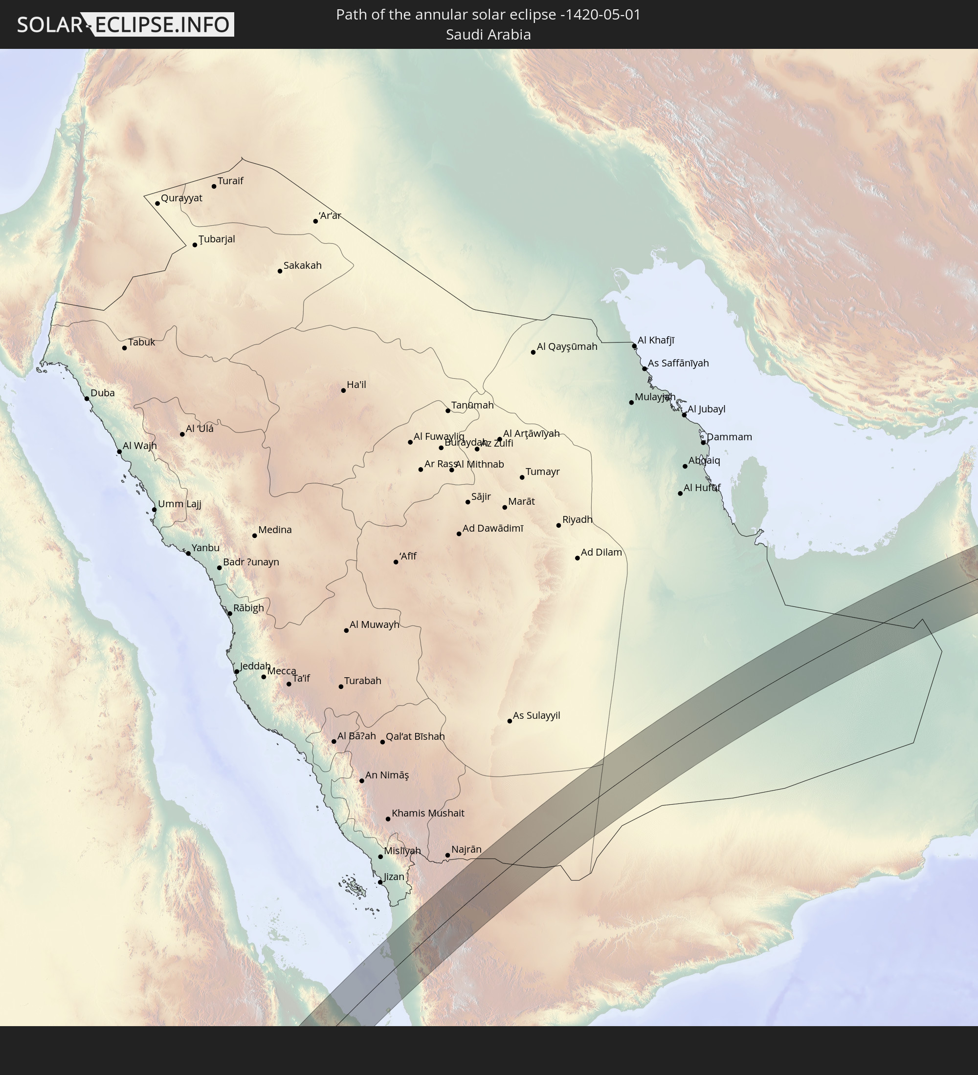 Saudi Arabia
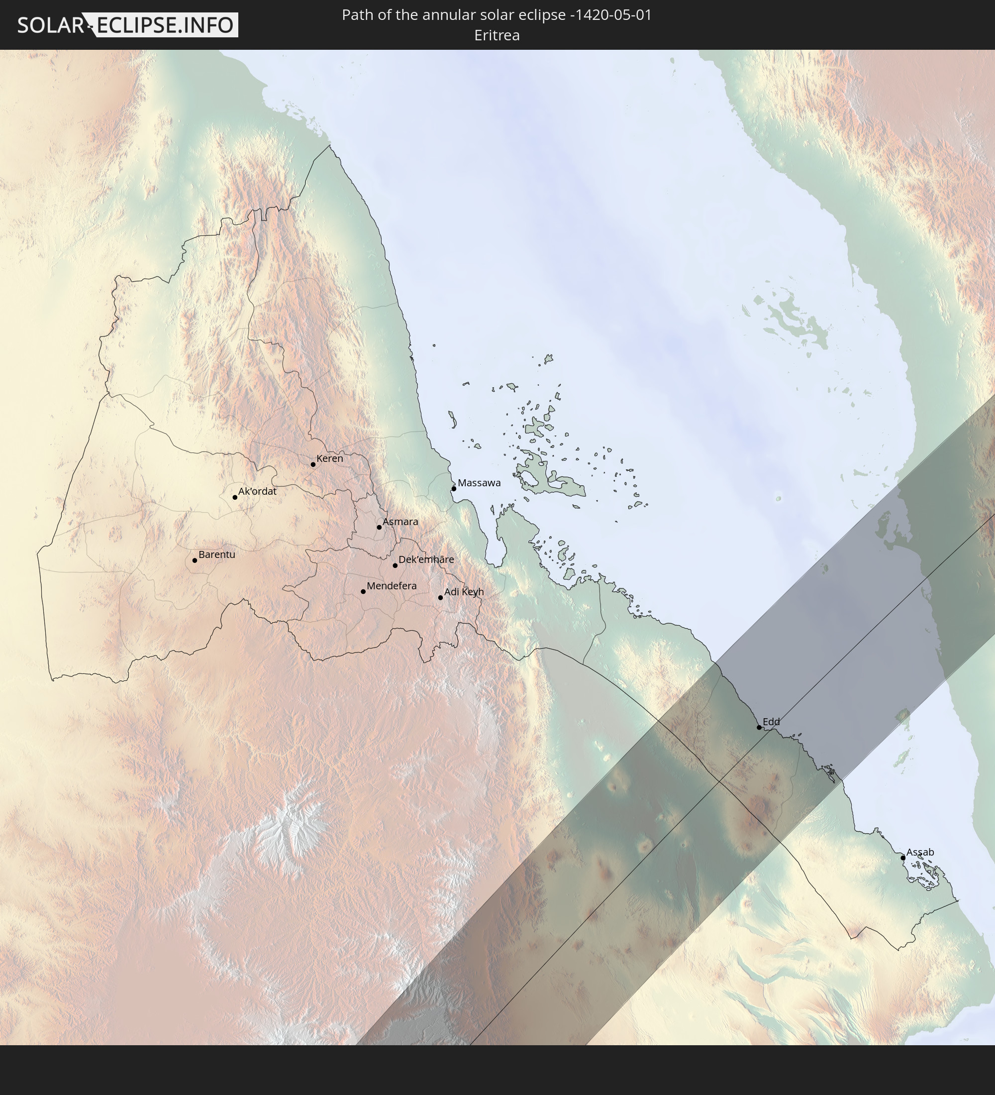 Eritrea
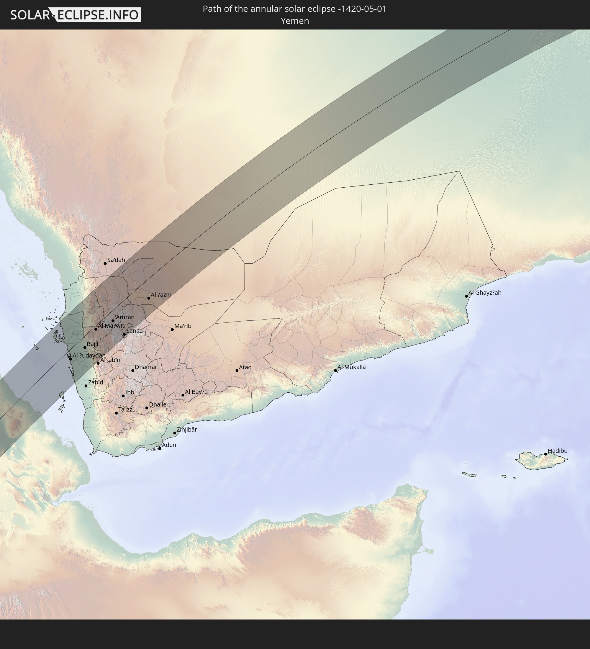 Yemen
Yemen
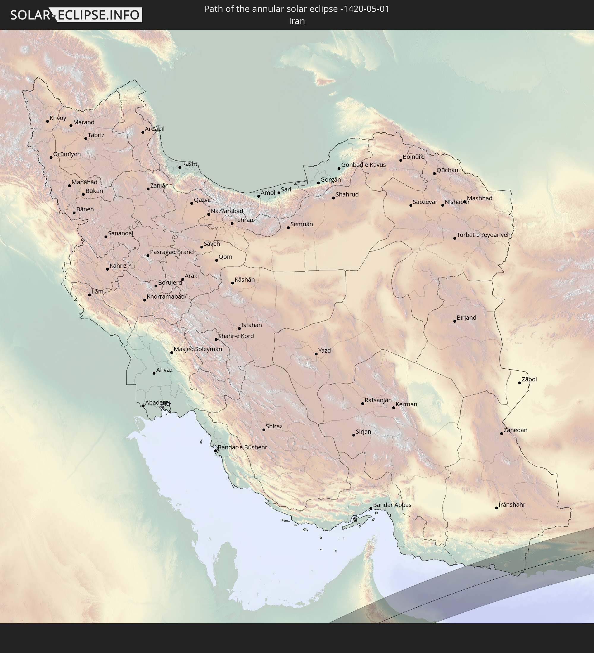 Iran
Iran
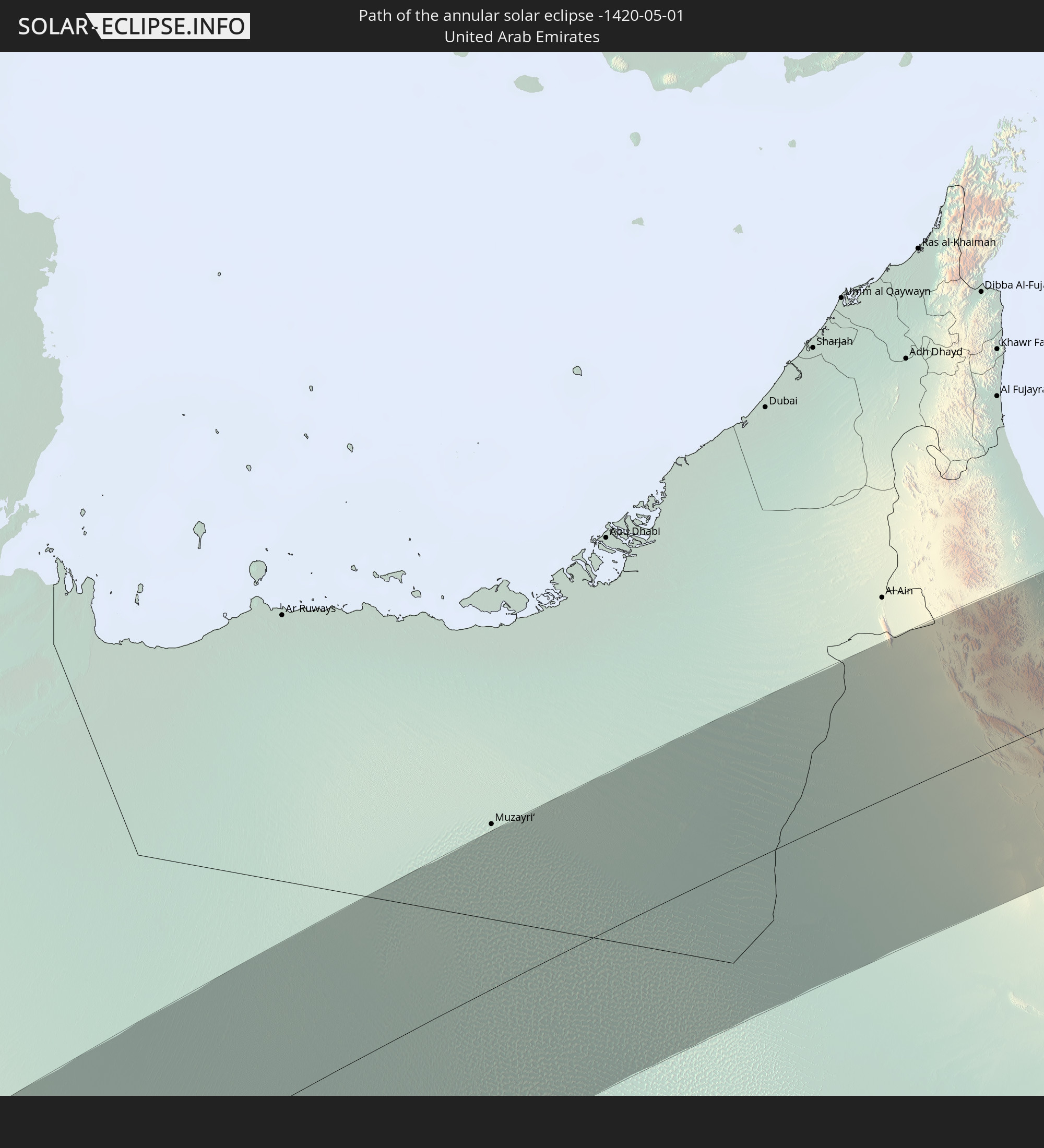 United Arab Emirates
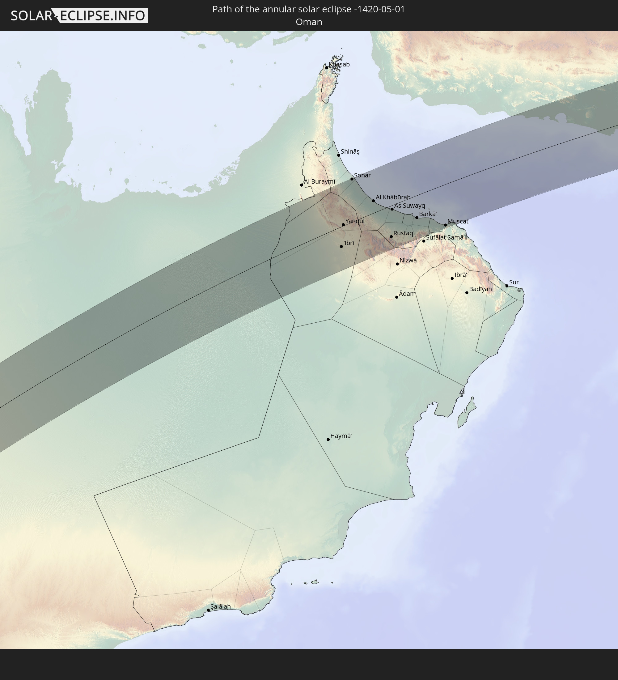 Oman
Oman
 Pakistan
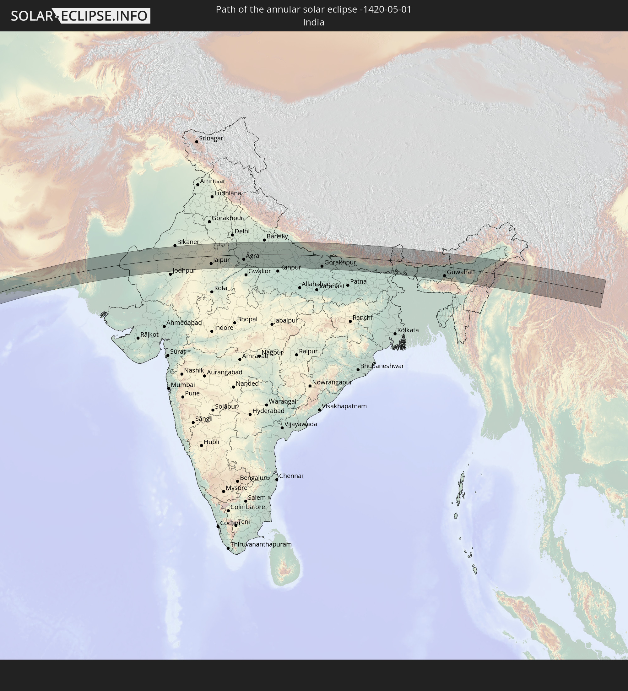 India
India
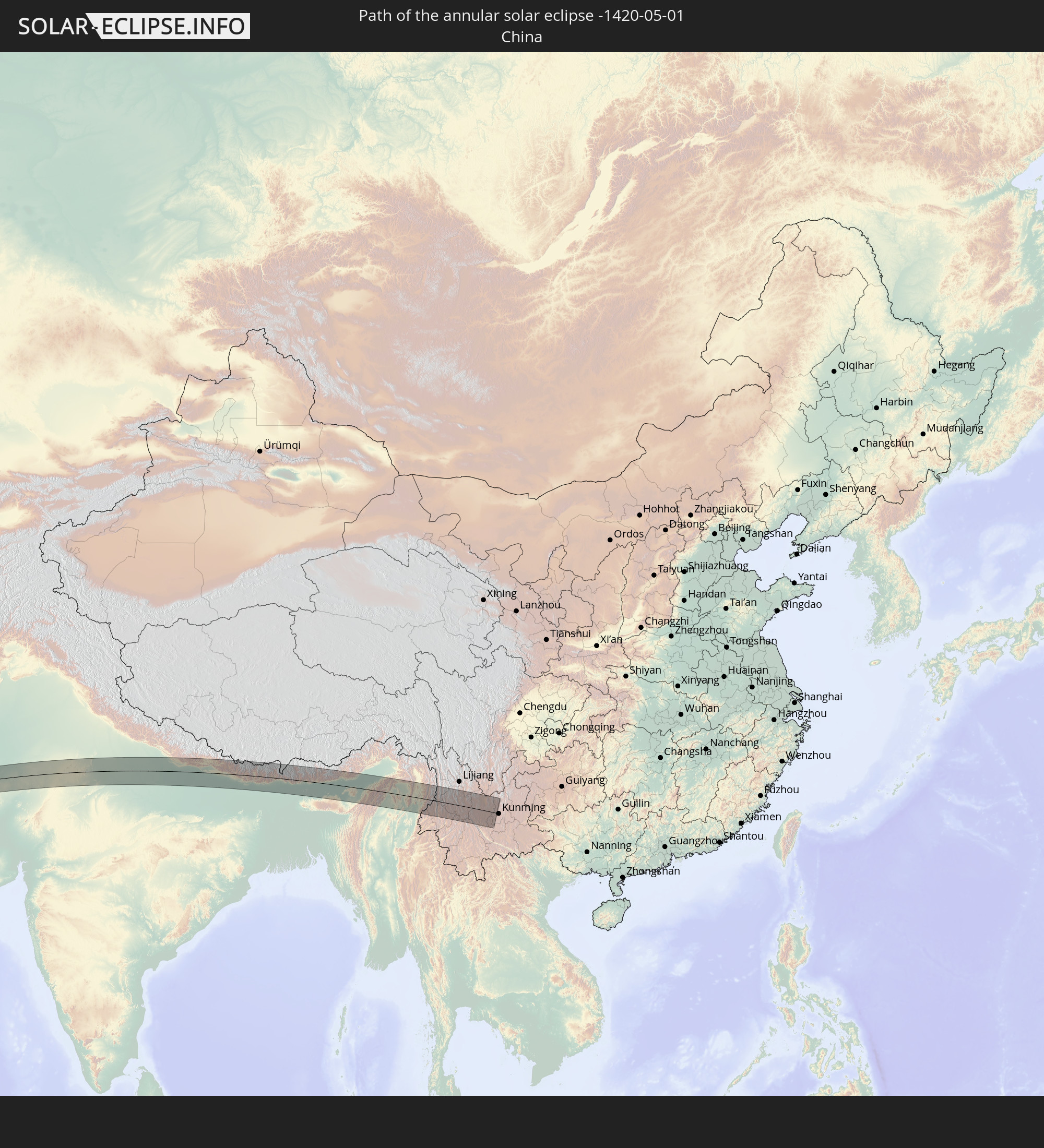 China
China
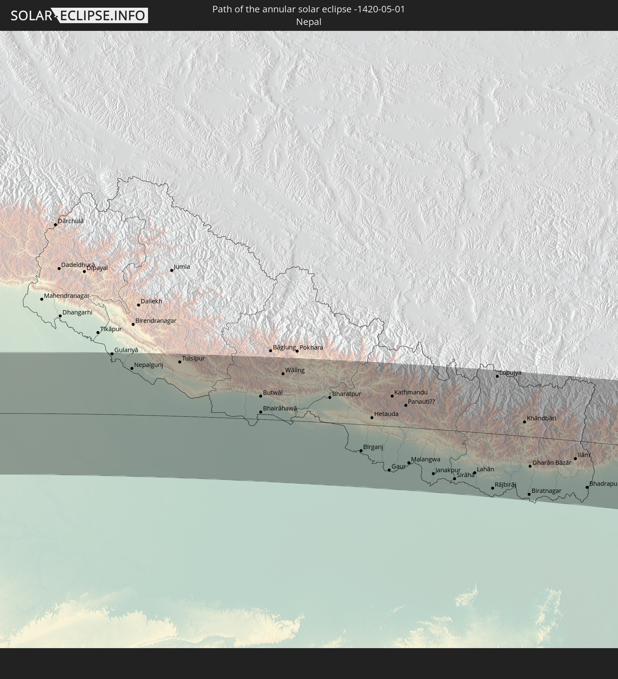 Nepal
Nepal
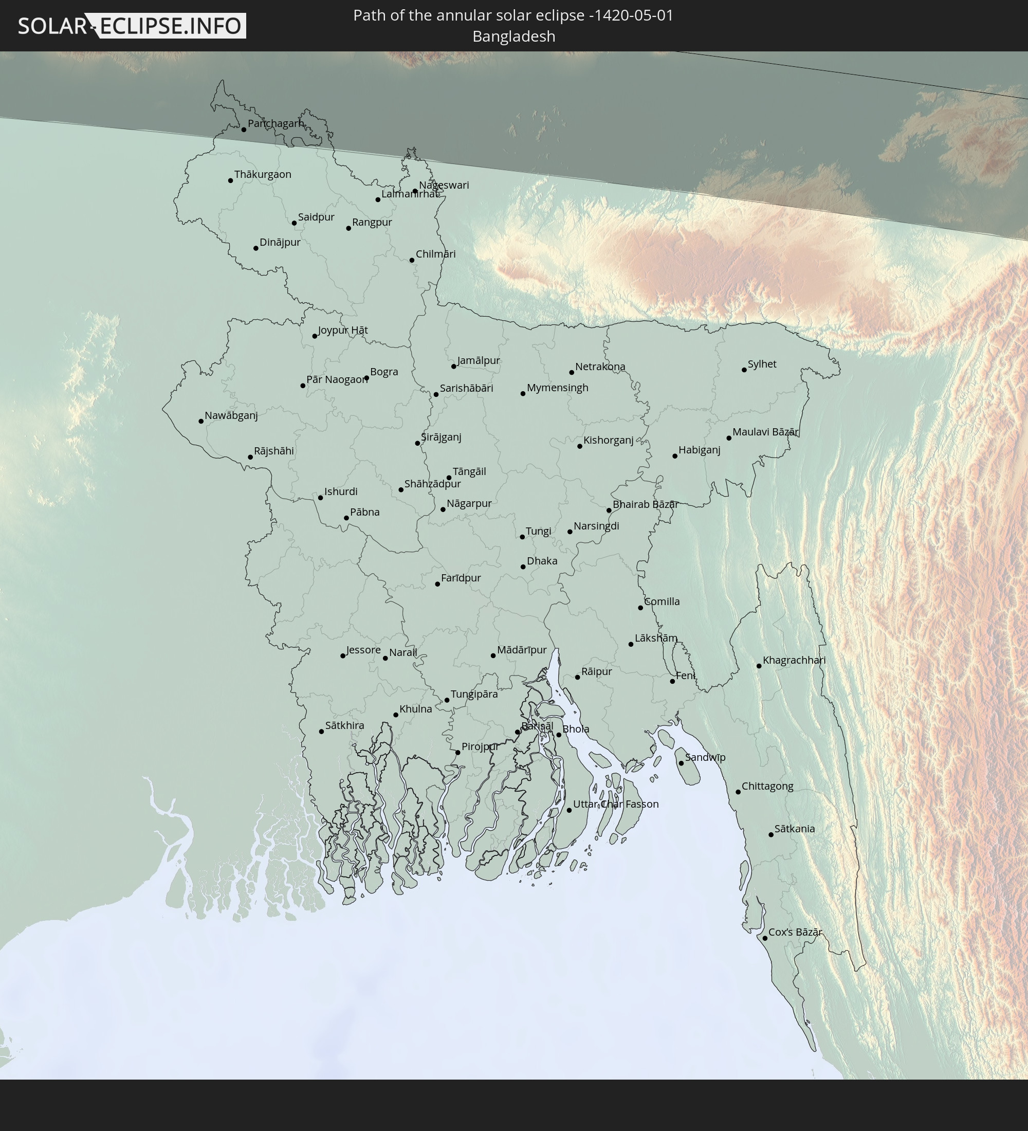 Bangladesh
 Bhutan
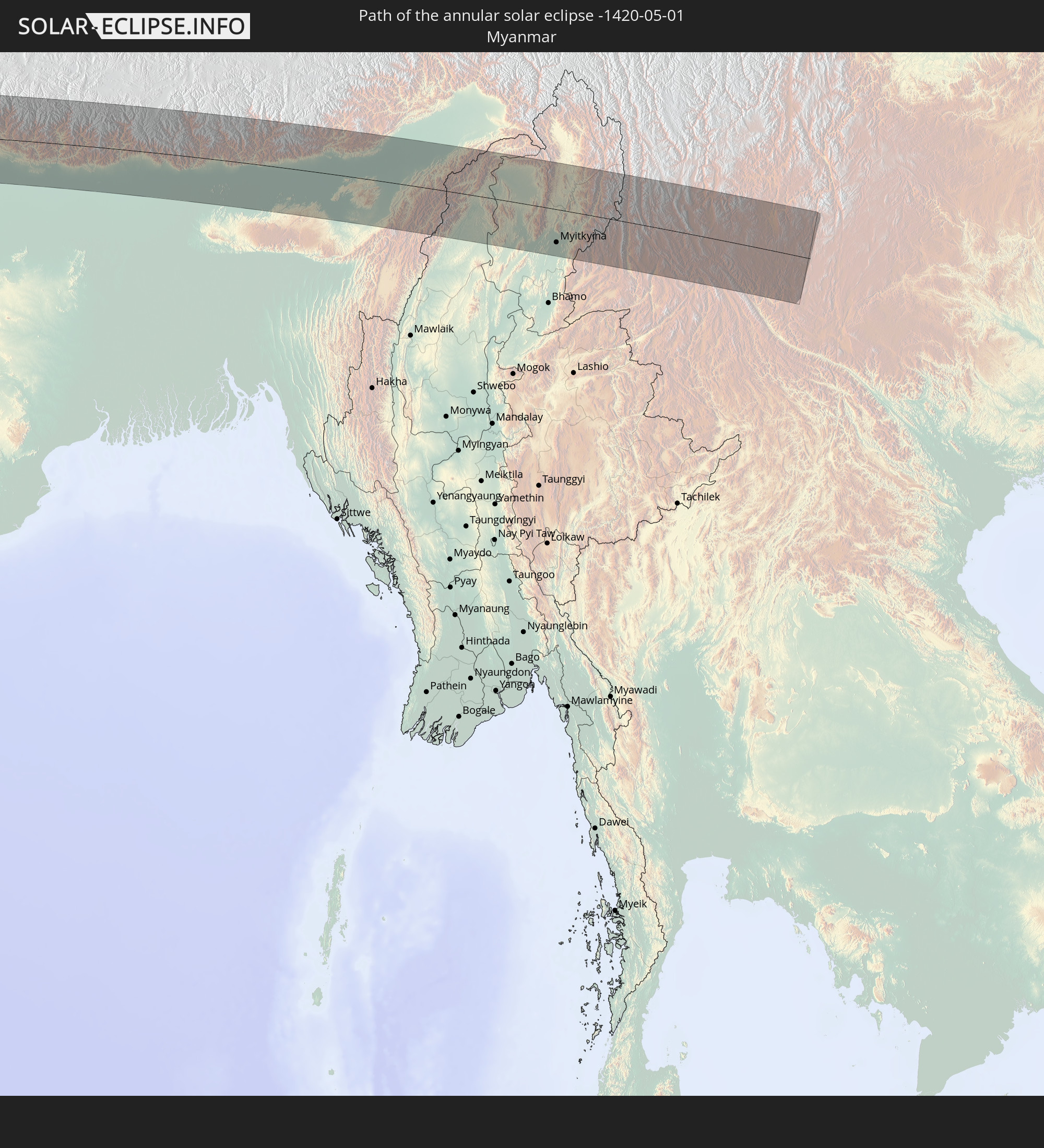 Myanmar
In den folgenden Ländern ist die Sonnenfinsternis partiell zu sehen
 Russia
 Guinea
 Saint Helena, Ascension and Tristan da Cunha
 Sierra Leone
 Mali
Mali
 Liberia
 Algeria
 Ivory Coast
 Burkina Faso
 Ghana
Ghana
 Togo
Togo
 Niger
Niger
 Benin
Benin
 Nigeria
 Bouvet Island
 Equatorial Guinea
 São Tomé and Príncipe
 Italy
Italy
 Tunisia
 Cameroon
 Gabon
Gabon
 Libya
Libya
 Republic of the Congo
 Angola
 Namibia
 Democratic Republic of the Congo
 Chad
Chad
 Malta
Malta
 Central African Republic
 South Africa
 Serbia
 Albania
 Greece
 Botswana
 Romania
 Republic of Macedonia
 Sudan
Sudan
 Zambia
 Ukraine
 Bulgaria
 Egypt
Egypt
 Zimbabwe
 Turkey
 Moldova
 Lesotho
 Rwanda
 Burundi
 Tanzania
 Uganda
 Mozambique
 Swaziland
 Cyprus
 Malawi
 Ethiopia
 Kenya
Kenya
 State of Palestine
 Israel
 Saudi Arabia
 Jordan
 Lebanon
 Syria
Syria
 Eritrea
 Iraq
Iraq
 Georgia
 French Southern and Antarctic Lands
 Somalia
 Djibouti
 Yemen
Yemen
 Madagascar
 Comoros
 Armenia
 Iran
Iran
 Azerbaijan
 Mayotte
 Seychelles
 Kazakhstan
 Kuwait
 Bahrain
 Qatar
Qatar
 United Arab Emirates
 Oman
Oman
 Turkmenistan
 Réunion
 Uzbekistan
 Mauritius
 Afghanistan
 Pakistan
 Tajikistan
 India
India
 Kyrgyzstan
 British Indian Ocean Territory
 Maldives
 China
China
 Sri Lanka
 Nepal
Nepal
 Mongolia
 Bangladesh
 Bhutan
 Myanmar
 Indonesia
 Thailand
 Malaysia
 Laos
Laos
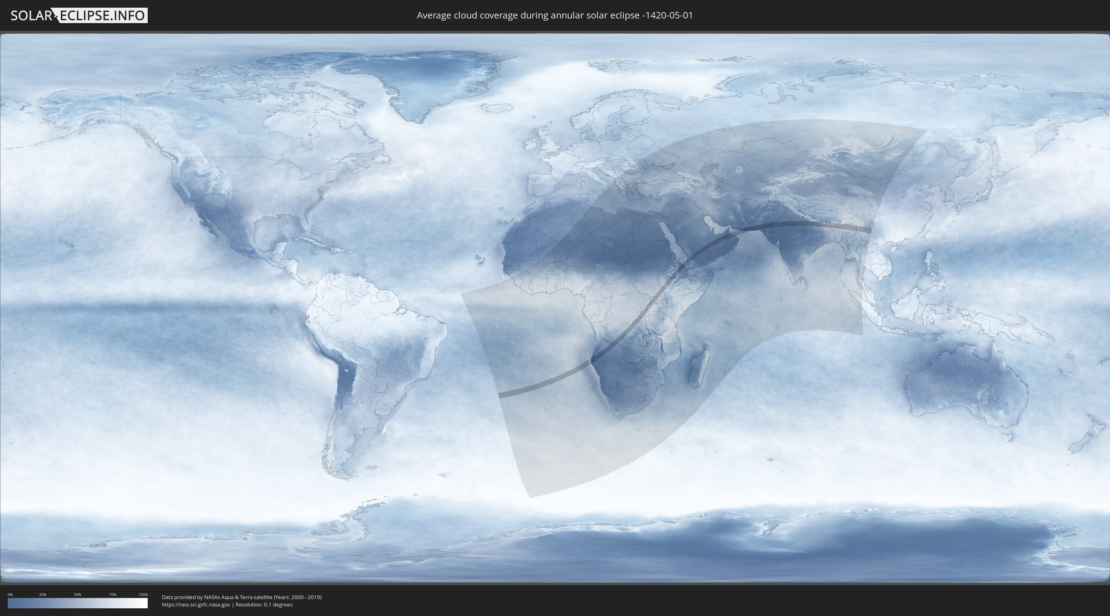
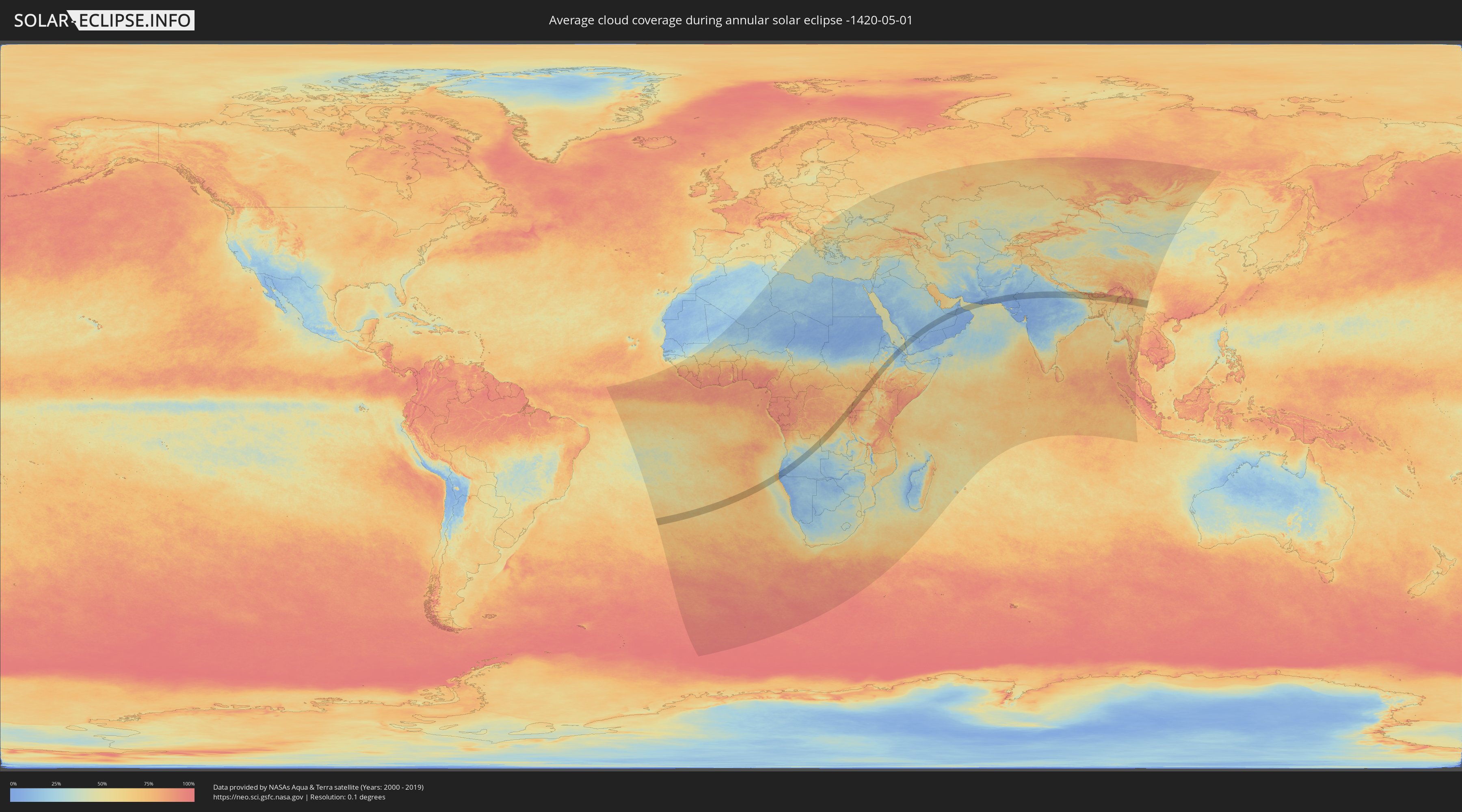
How will be the weather during the annular solar eclipse on 05/01/-1420?
Where is the best place to see the annular solar eclipse of 05/01/-1420?
The following maps show the average cloud coverage for the day of the annular solar eclipse.
With the help of these maps, it is possible to find the place along the eclipse path, which has the best
chance of a cloudless sky.
Nevertheless, you should consider local circumstances and inform about the weather of your chosen
observation site.
The data is provided by NASAs satellites
AQUA and TERRA.
The cloud maps are averaged over a period of 19 years (2000 - 2019).
Detailed country maps
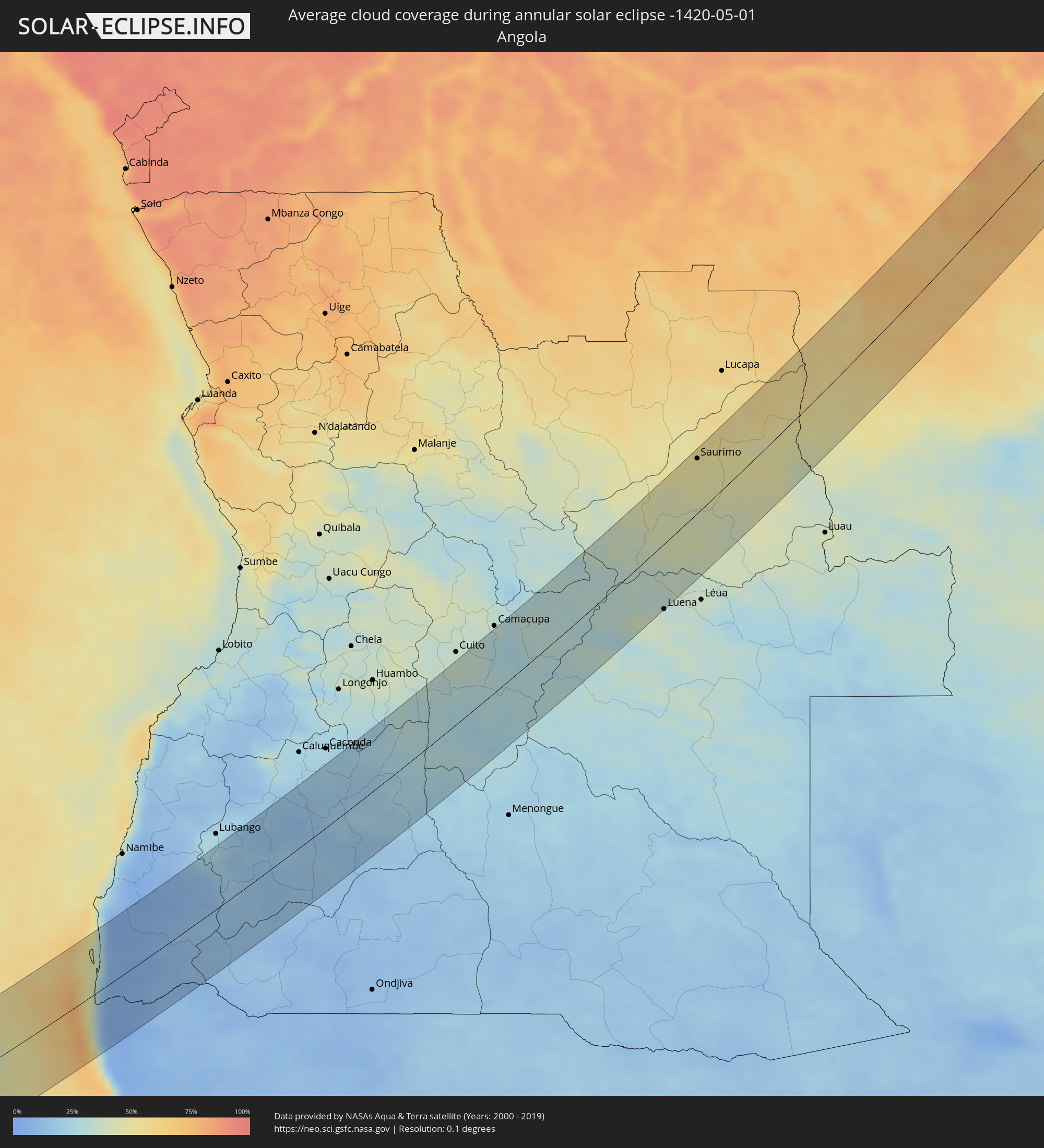 Angola
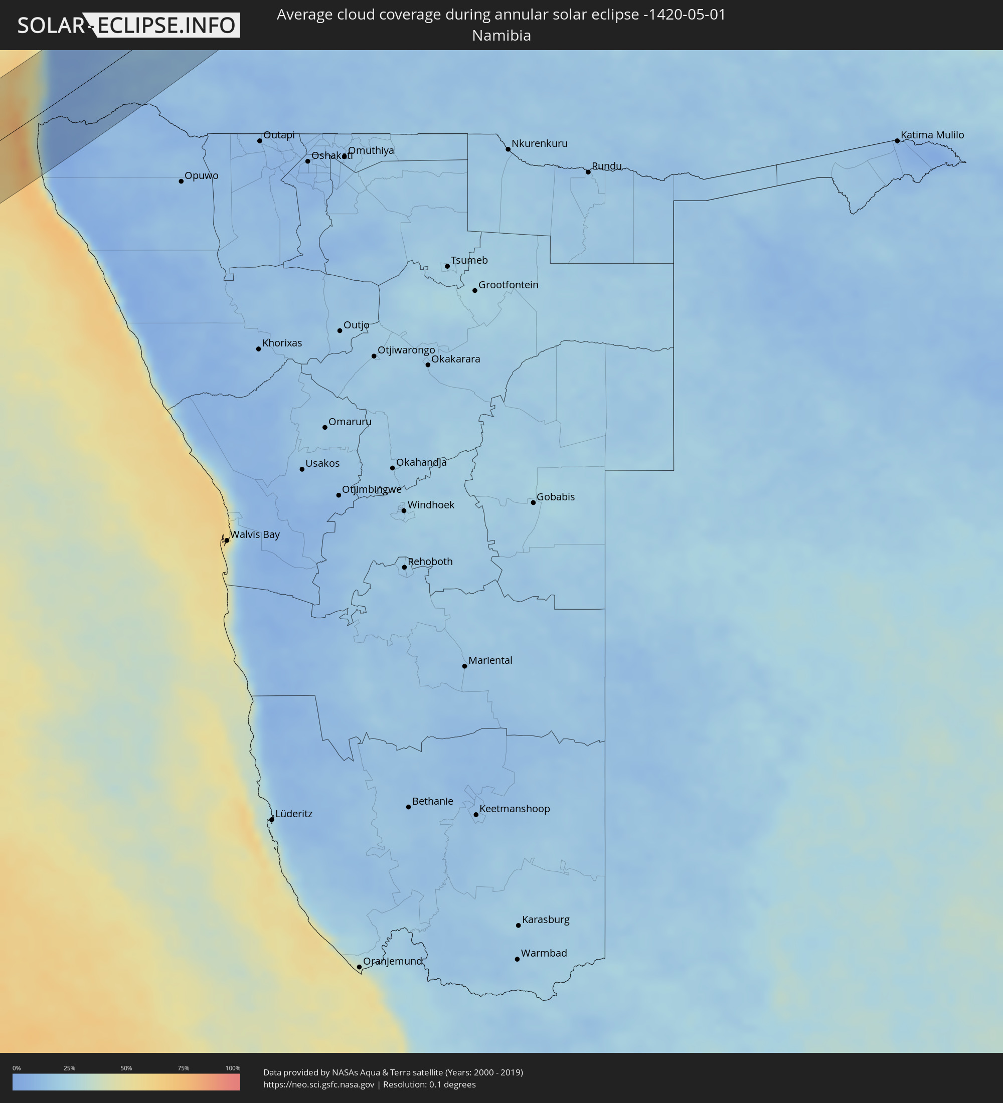 Namibia
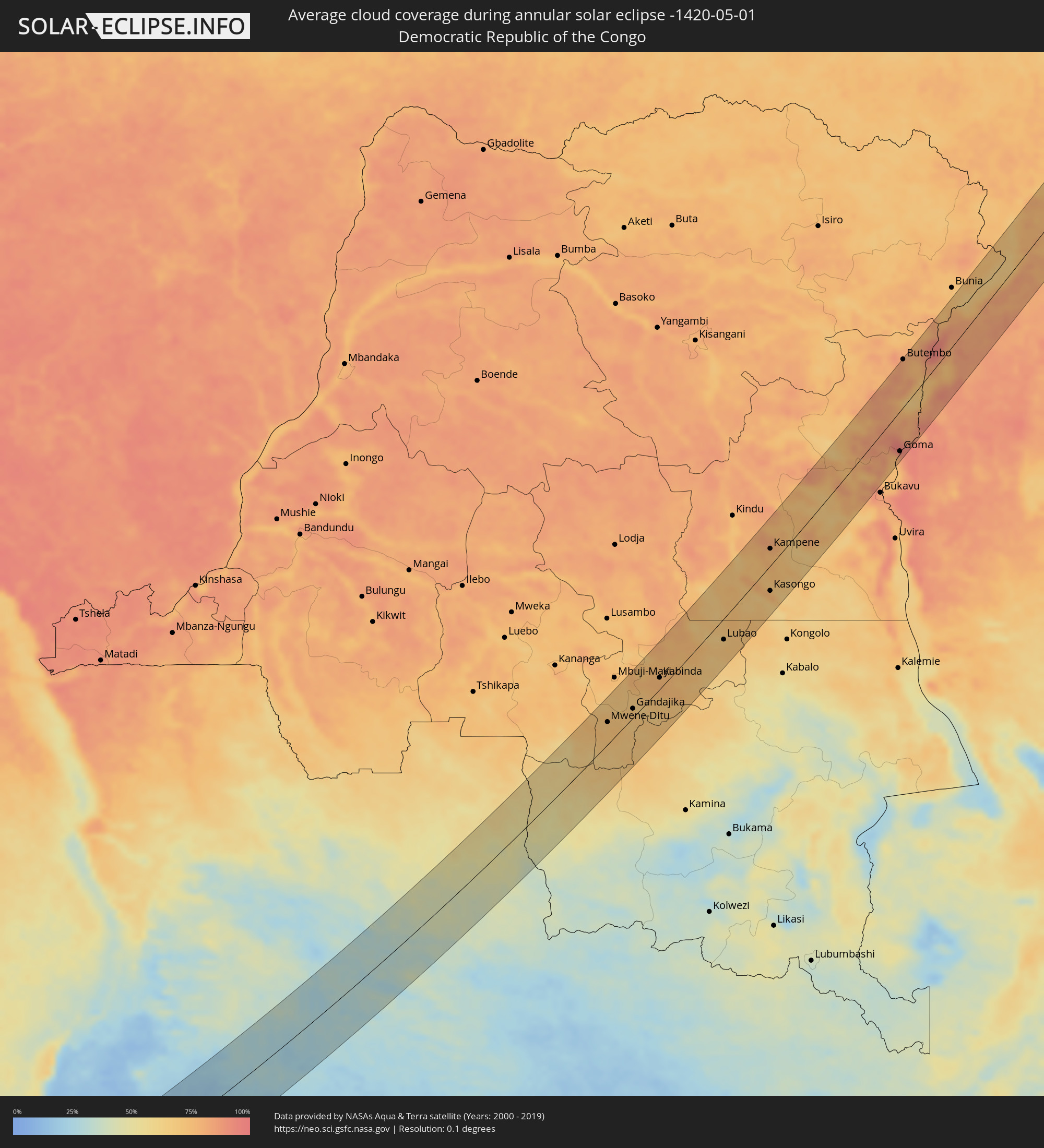 Democratic Republic of the Congo
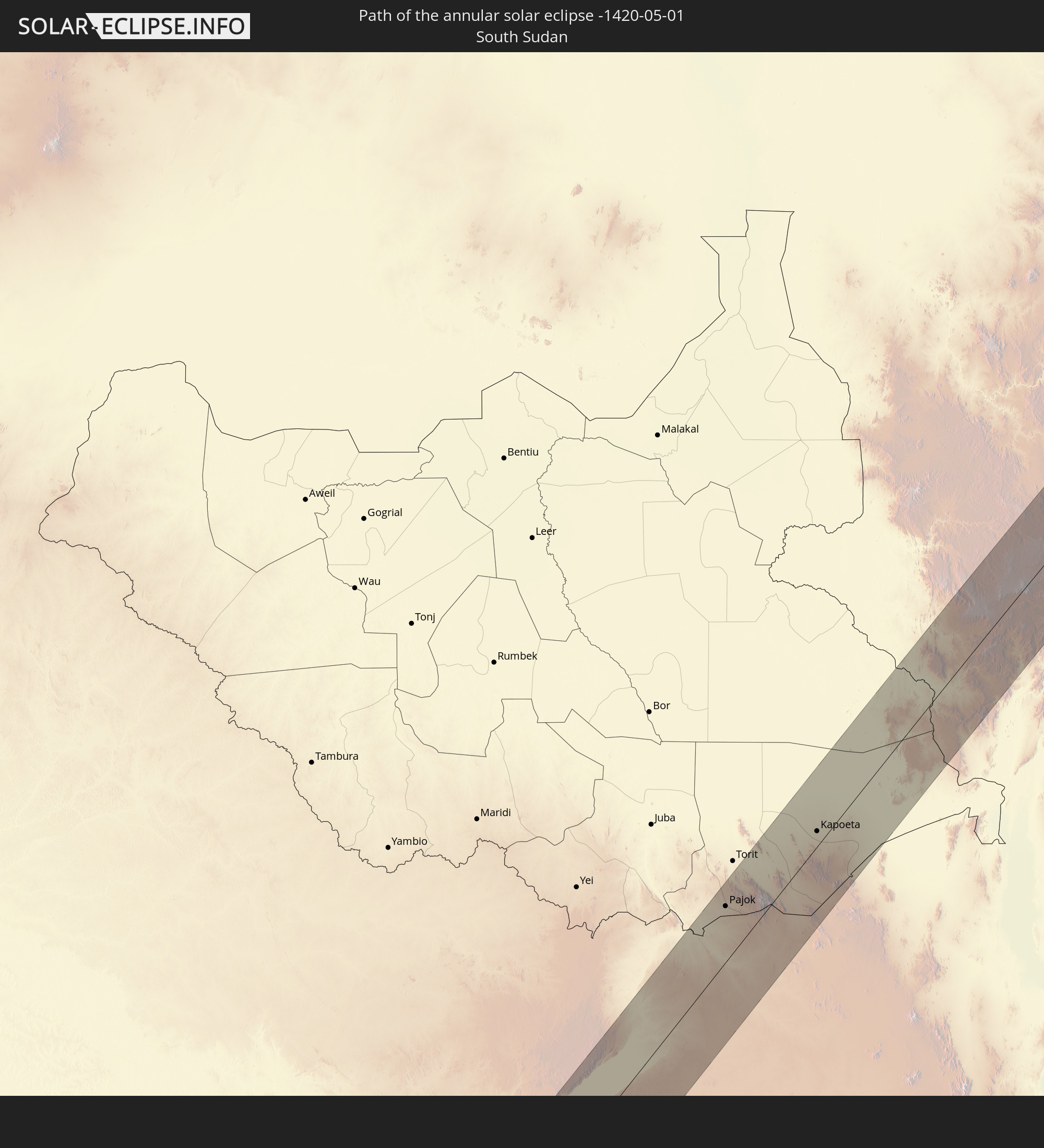
 South Sudan
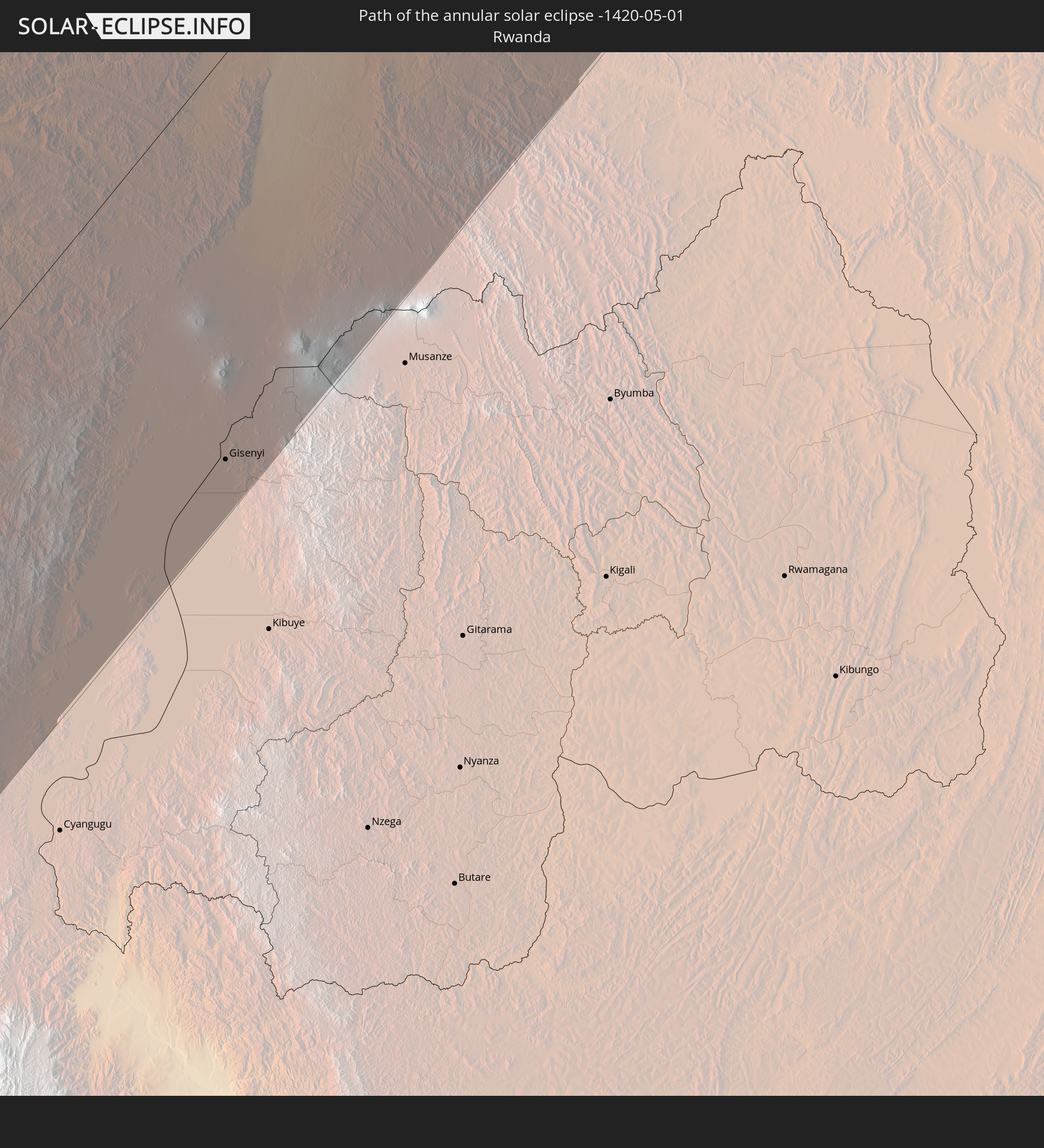
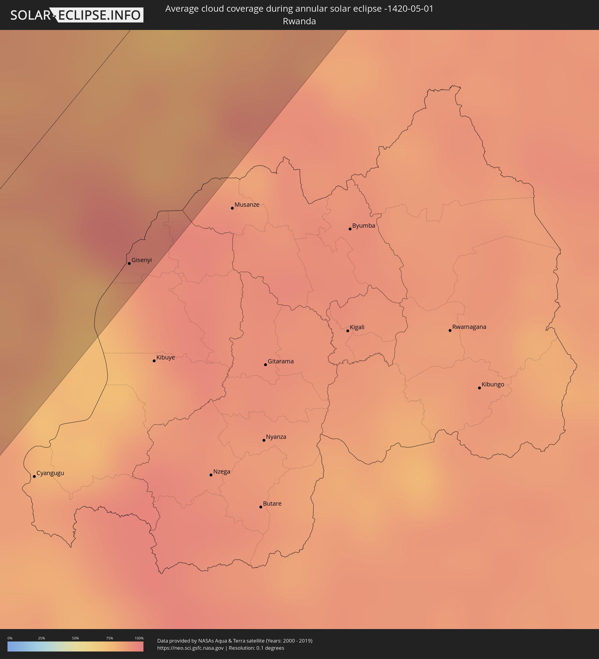 Rwanda
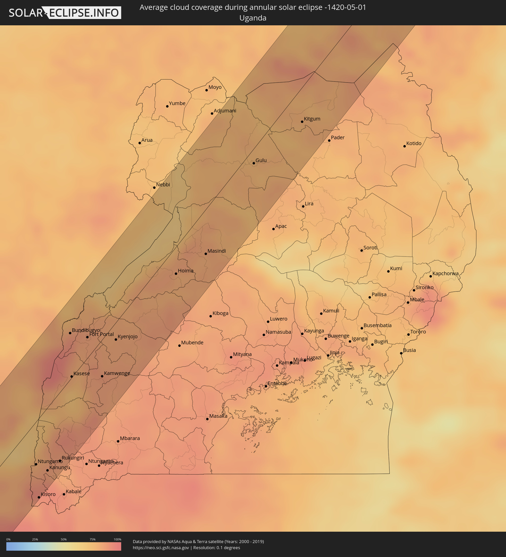 Uganda
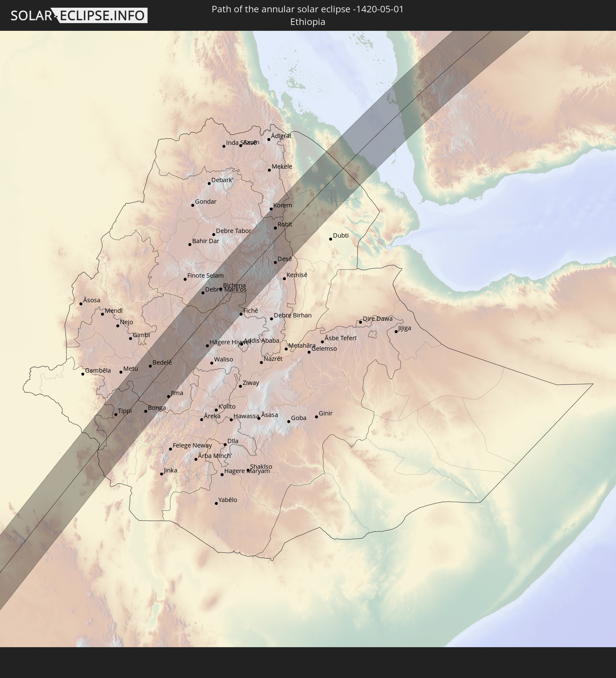
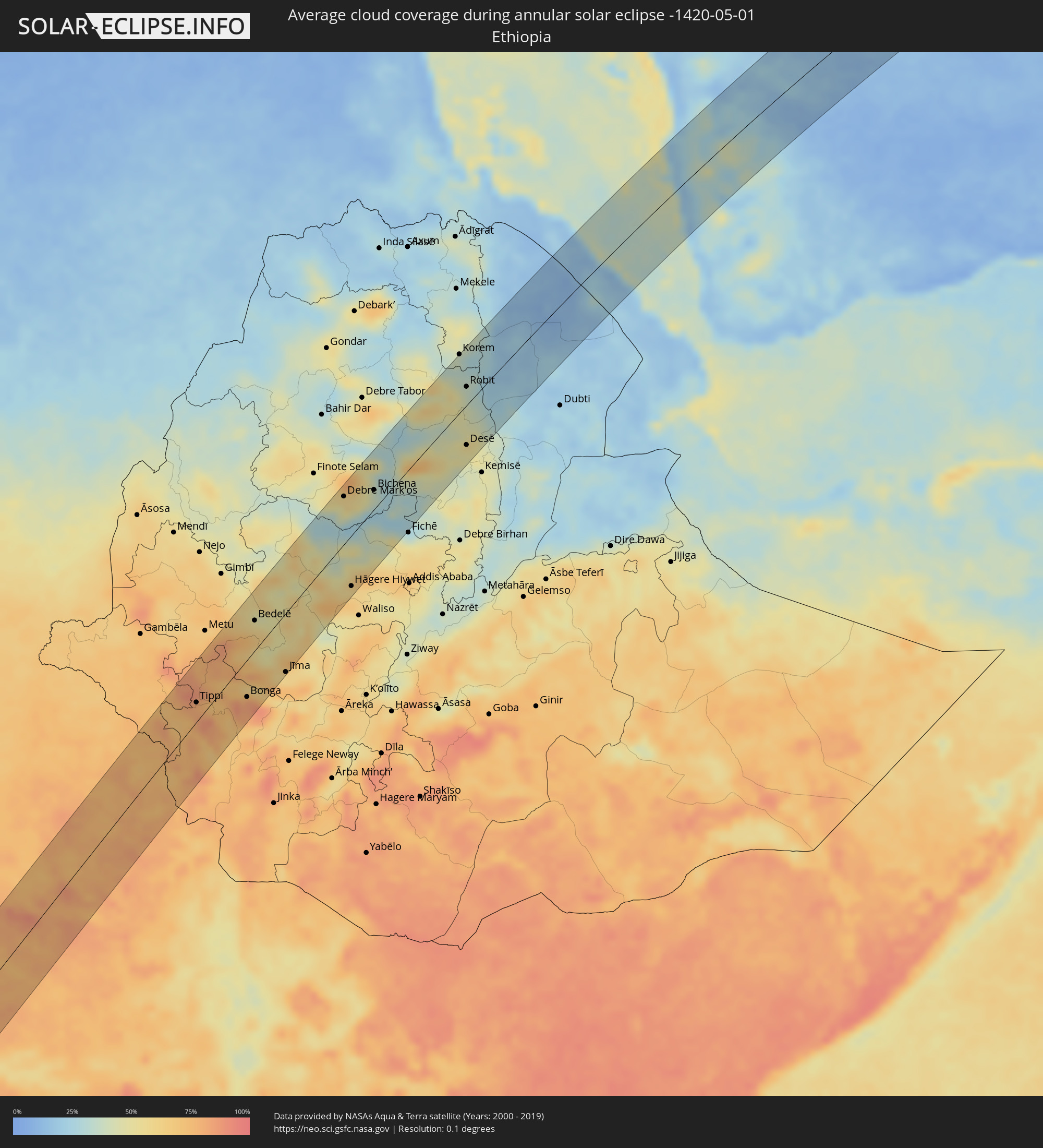 Ethiopia
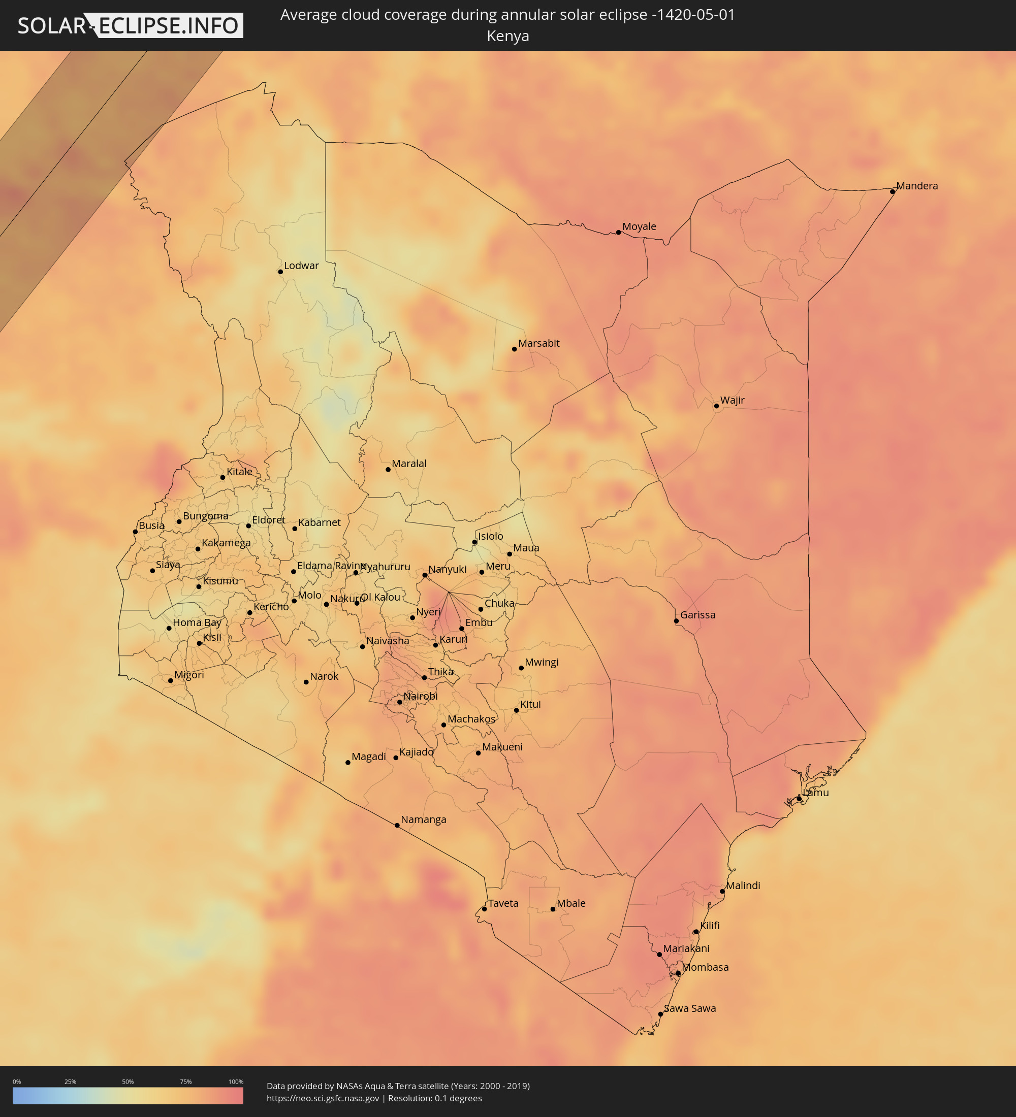 Kenya
Kenya
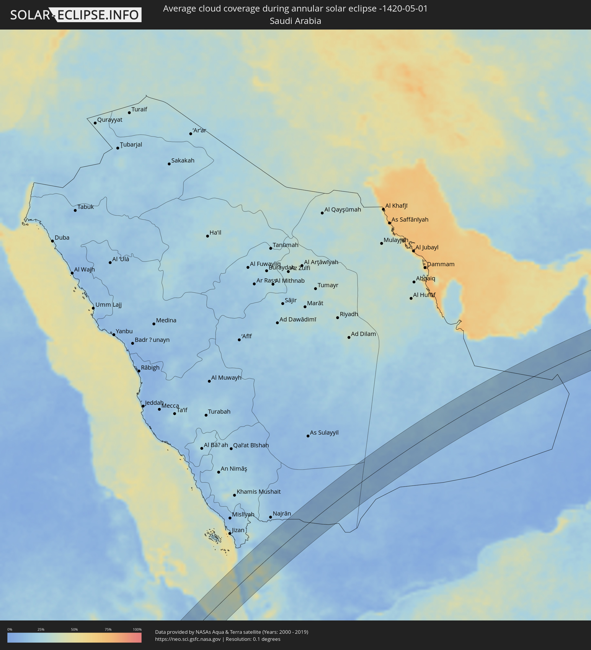 Saudi Arabia
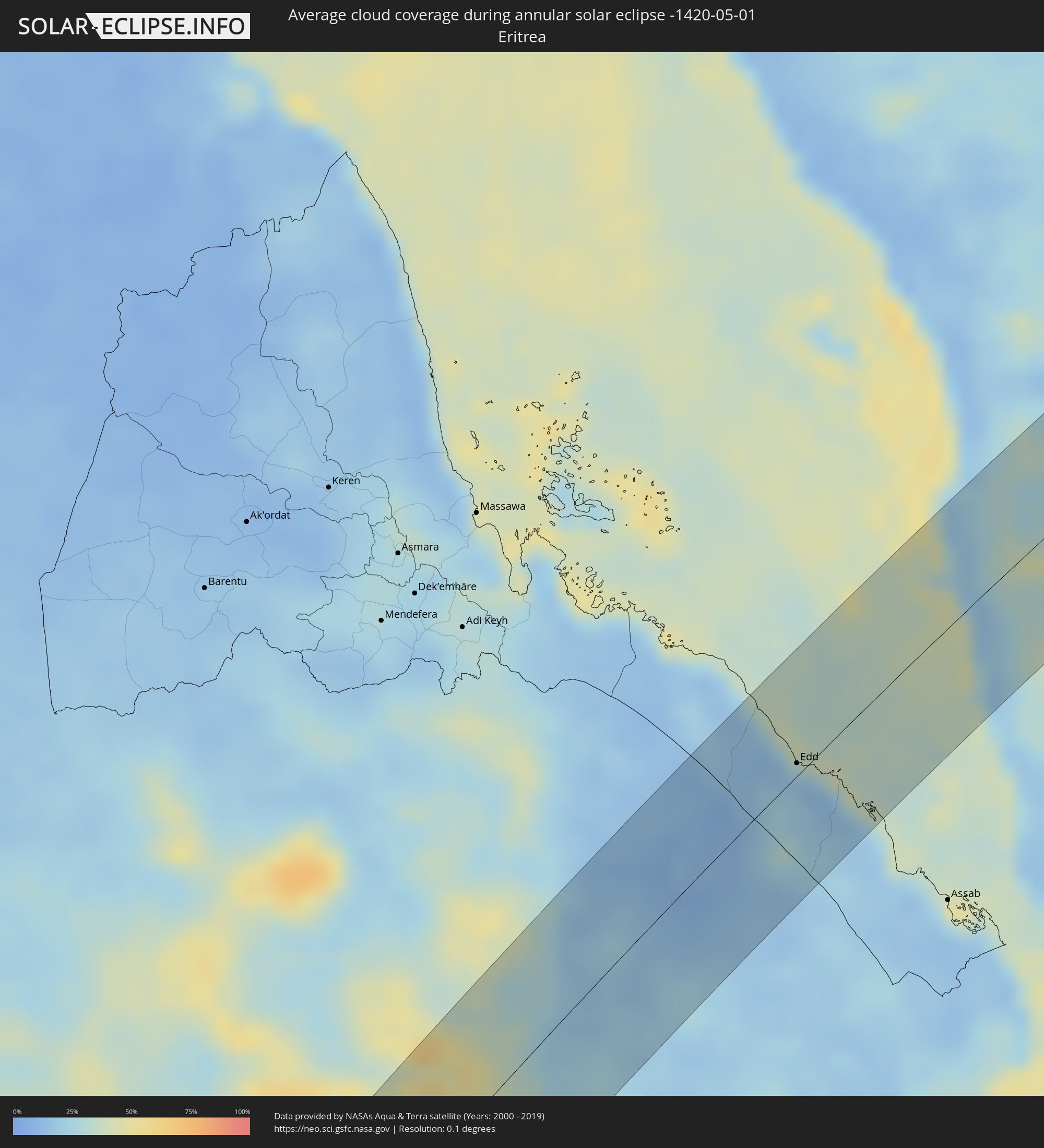 Eritrea
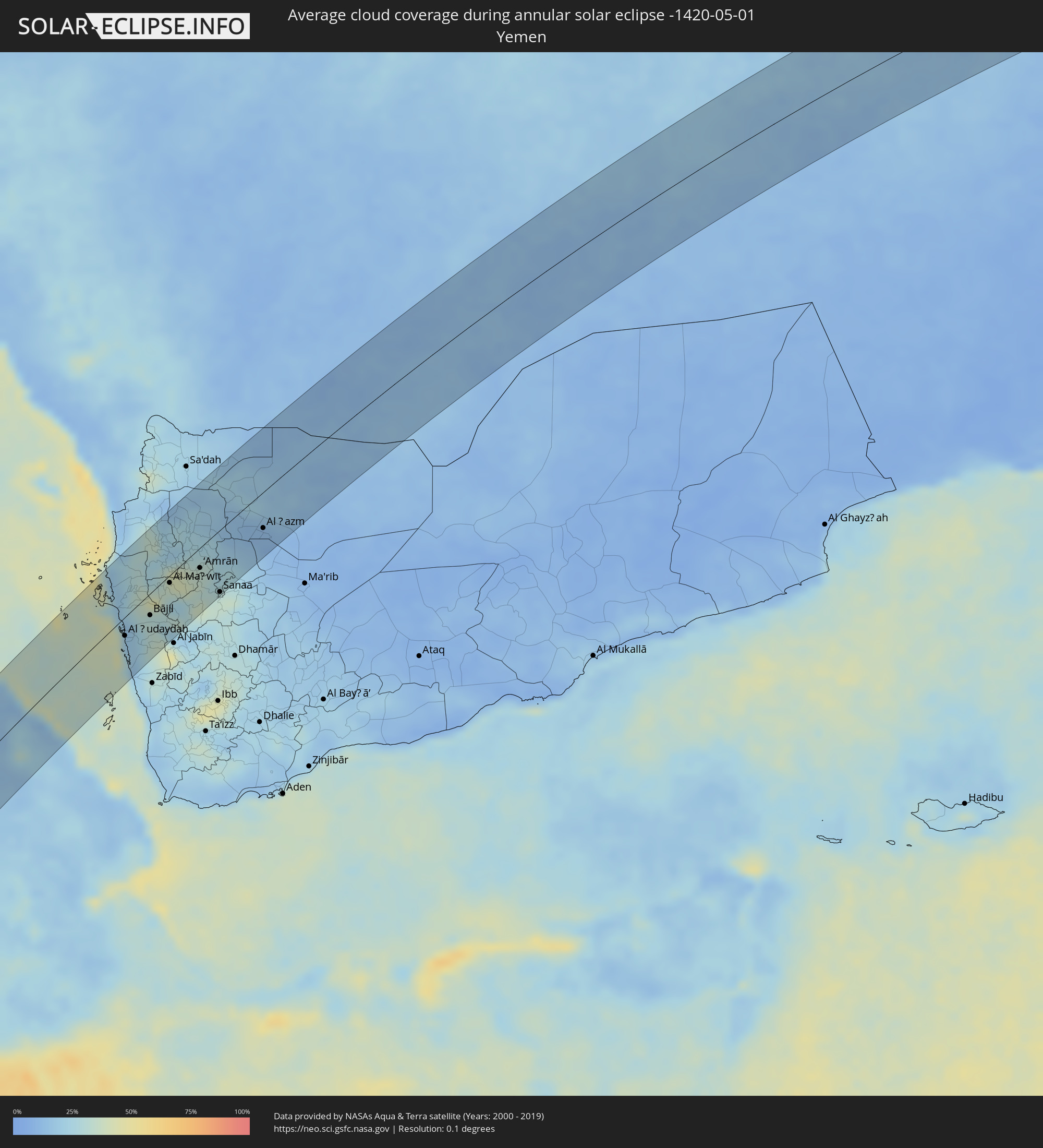 Yemen
Yemen
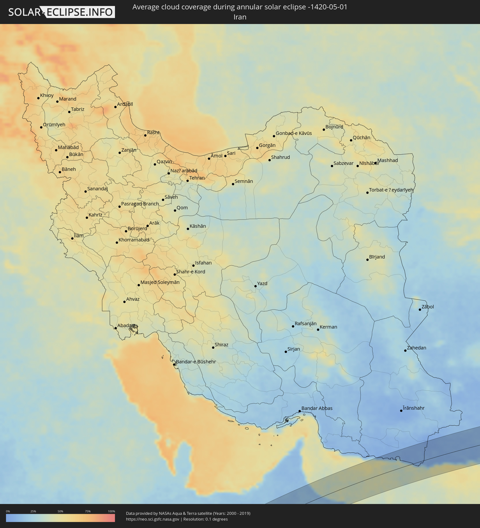 Iran
Iran
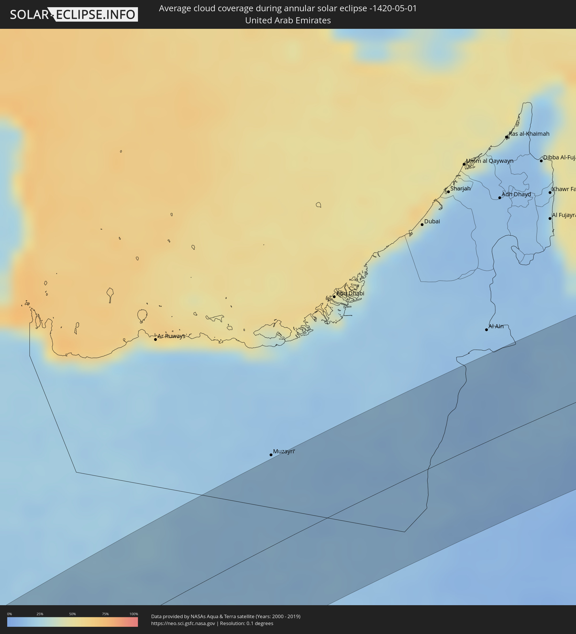 United Arab Emirates
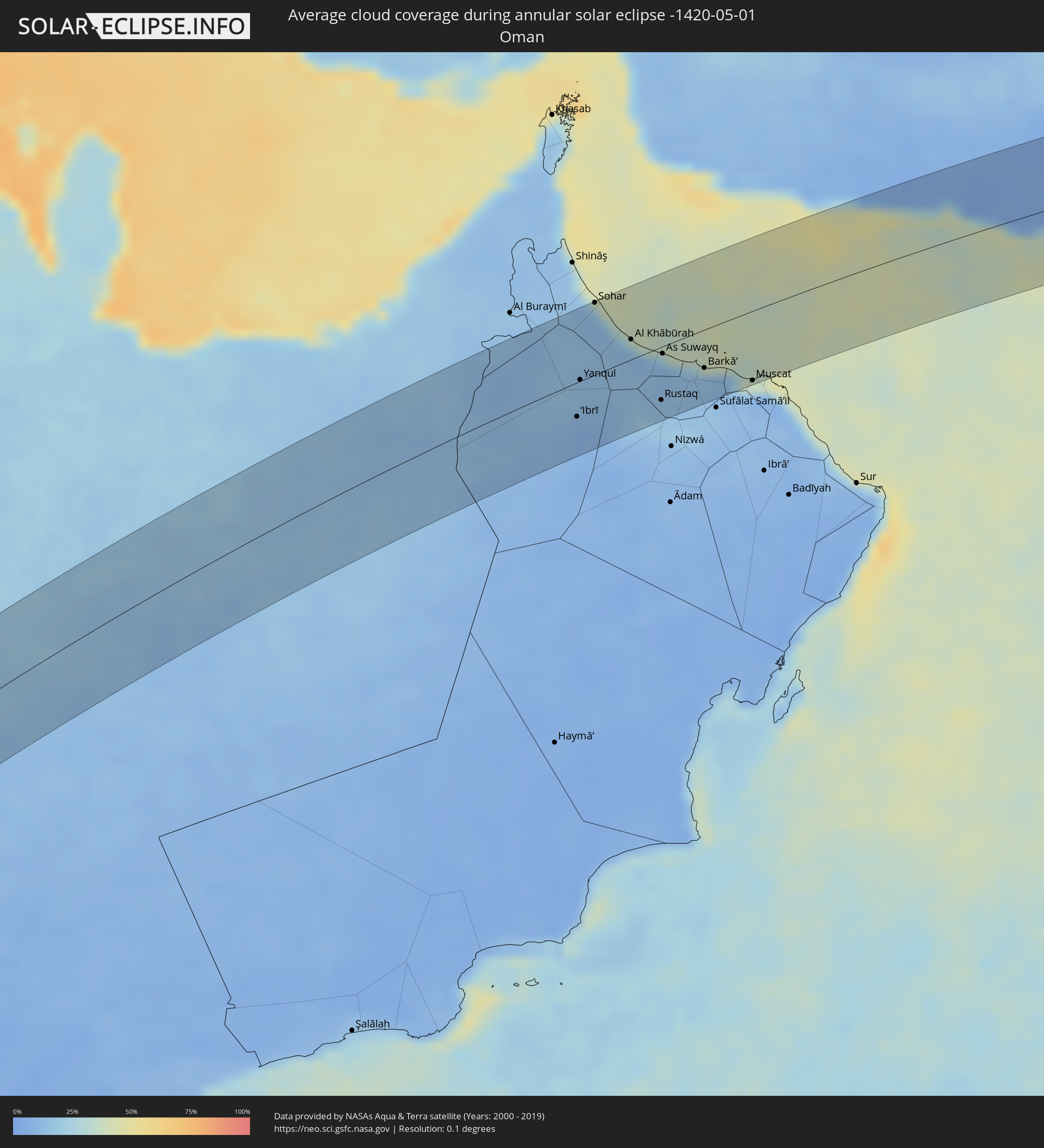 Oman
Oman
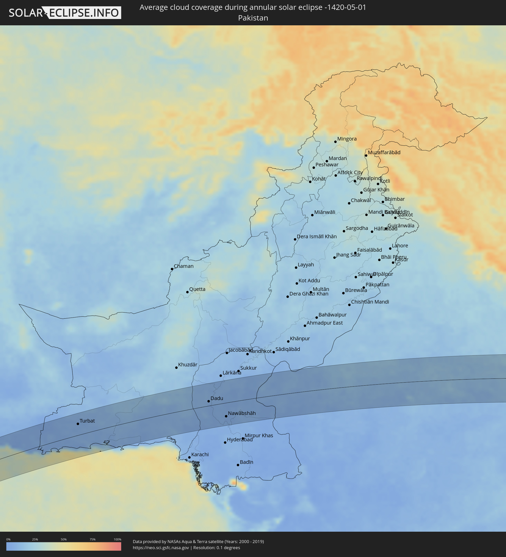 Pakistan
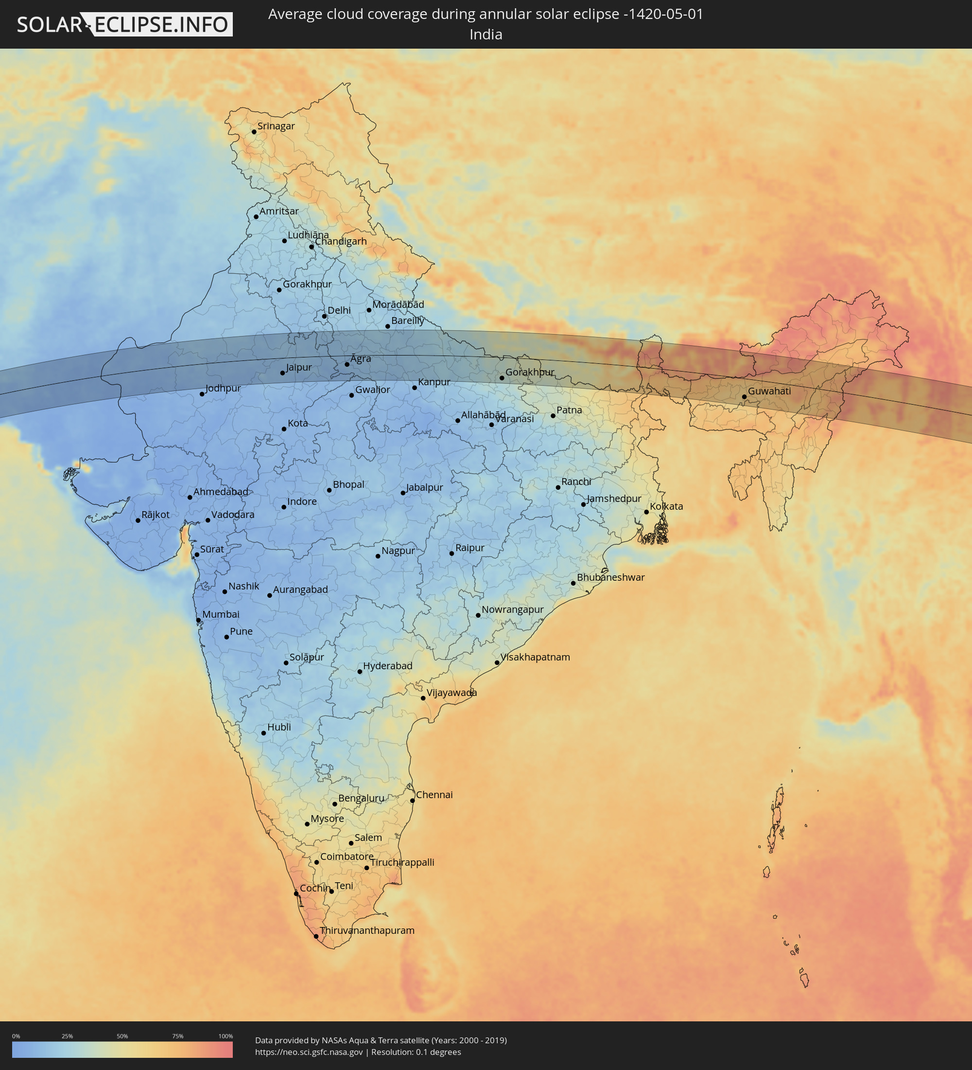 India
India
 China
China
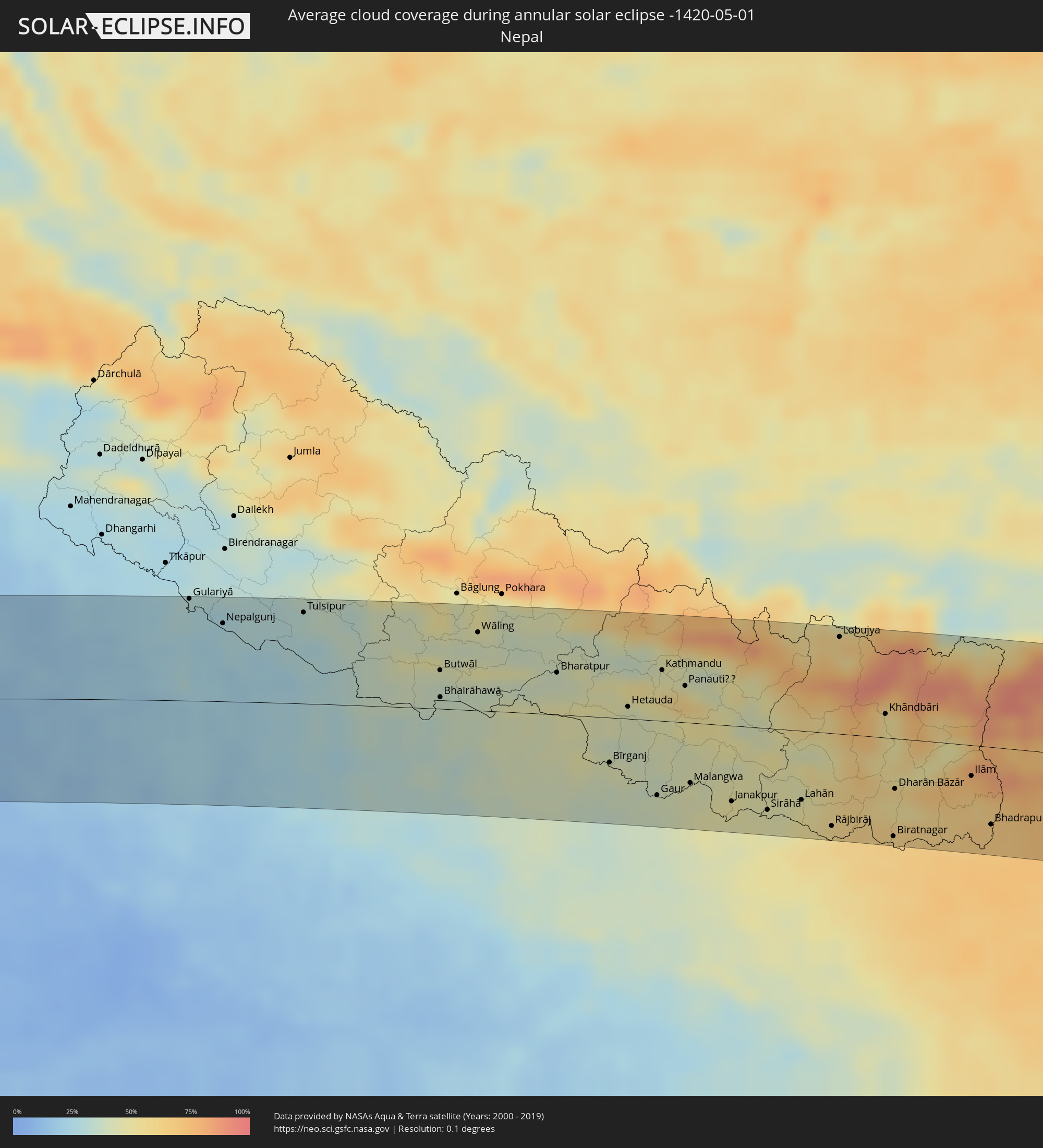 Nepal
Nepal
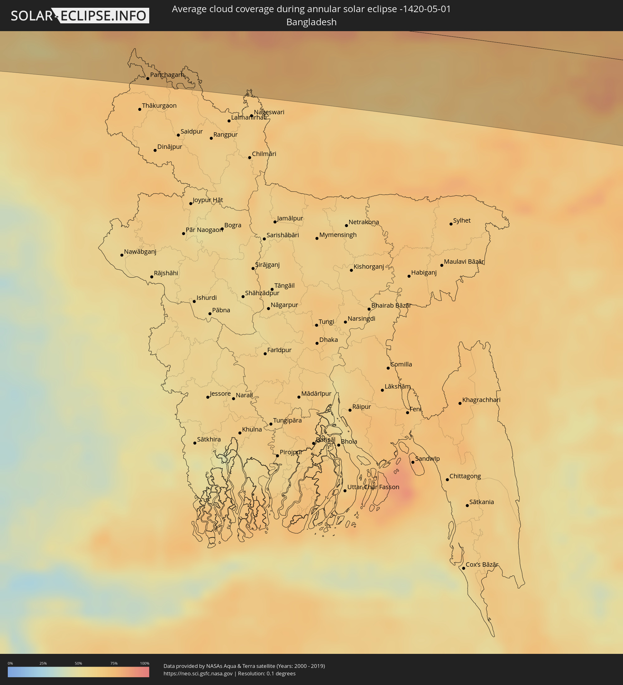 Bangladesh
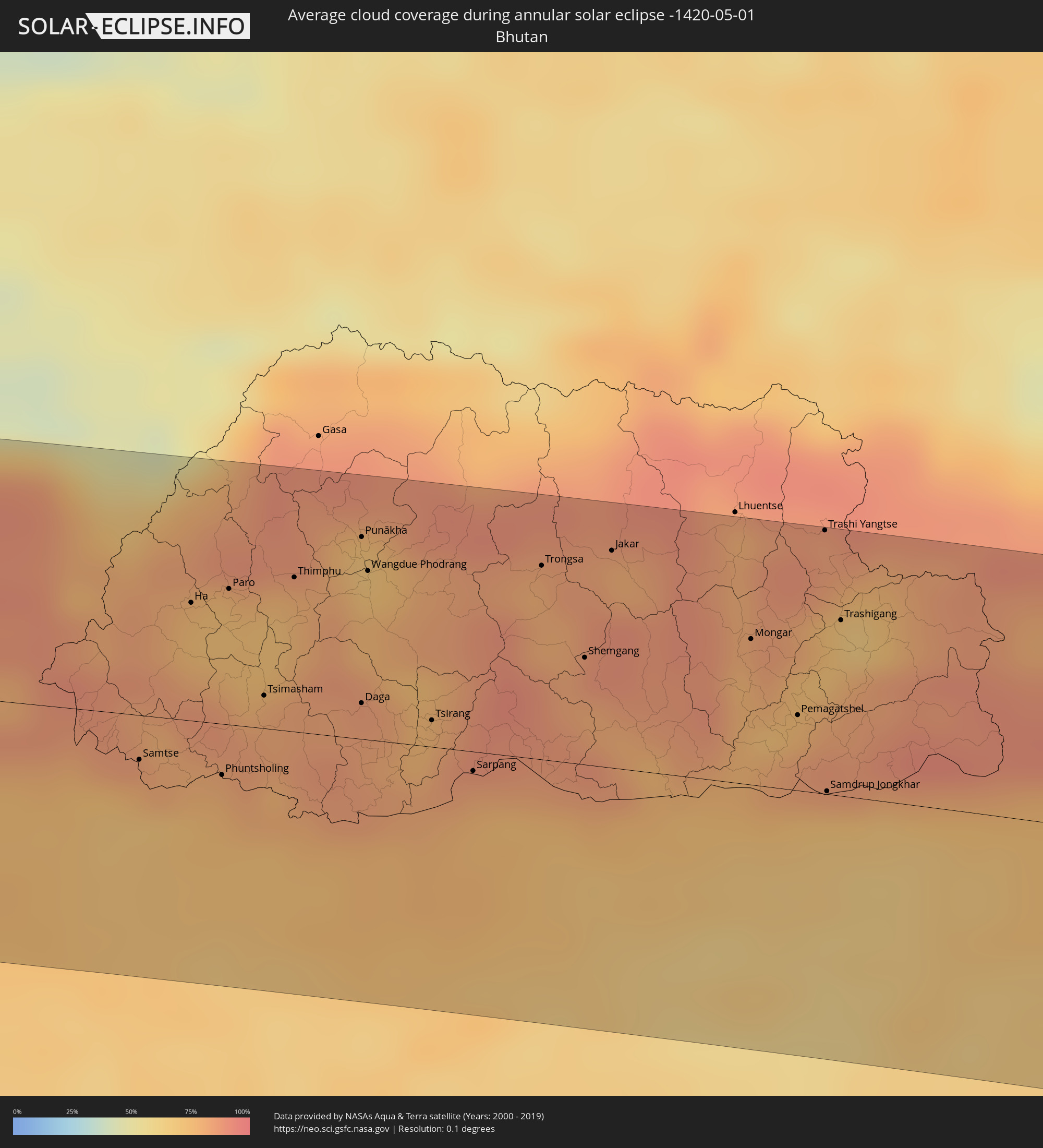 Bhutan
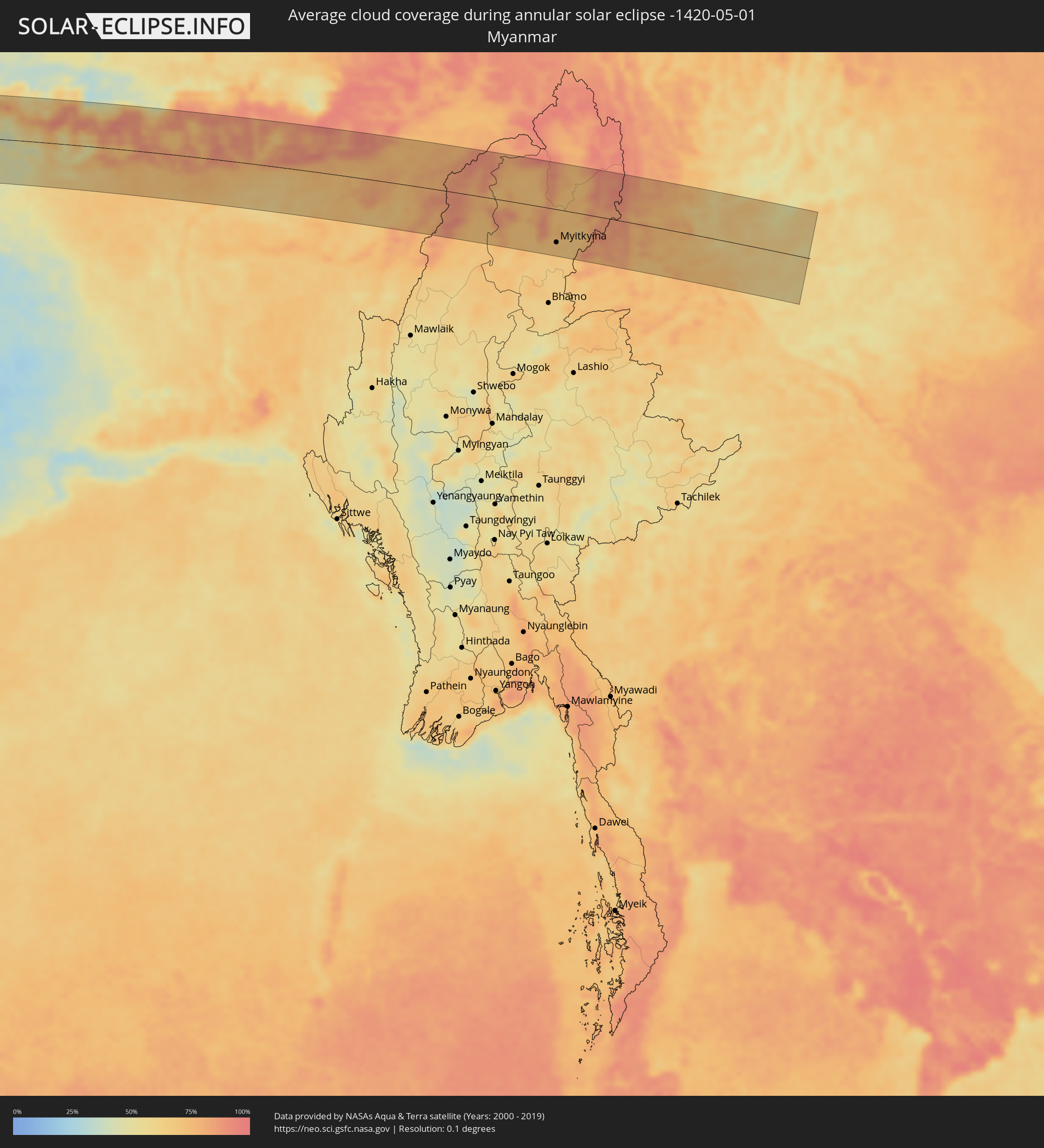 Myanmar
Cities inside the path of the eclipse
The following table shows all locations with a population of more than 5,000 inside the eclipse path. Cities which have more than 100,000 inhabitants are marked bold. A click at the locations opens a detailed map.
| City | Type | Eclipse duration | Local time of max. eclipse | Distance to central line | Ø Cloud coverage |
|
Saurimo, Lunda Sul
|
annular | - | 08:27:27 UTC+00:13 | 63 km | 48% |
|
Mwene-Ditu, Kasaï-Oriental
|
annular | - | 10:33:45 UTC+02:10 | 33 km | 72% |
|
Gandajika, Kasaï-Oriental
|
annular | - | 10:35:04 UTC+02:10 | 14 km | 69% |
|
Kabinda, Kasaï-Oriental
|
annular | - | 10:37:08 UTC+02:10 | 17 km | 77% |
|
Lubao, Kasaï-Oriental
|
annular | - | 10:40:46 UTC+02:10 | 31 km | 70% |
|
Kasongo, Maniema
|
annular | - | 10:44:22 UTC+02:10 | 36 km | 76% |
|
Kampene, Maniema
|
annular | - | 10:46:13 UTC+02:10 | 24 km | 75% |
|
Sake, Nord Kivu
|
annular | - | 10:55:02 UTC+02:10 | 33 km | 79% |
|
Goma, Nord Kivu
|
annular | - | 10:55:08 UTC+02:10 | 56 km | 81% |
|
Gisenyi, Western Province
|
annular | - | 10:55:07 UTC+02:10 | 60 km | 89% |
|
Butembo, Nord Kivu
|
annular | - | 10:59:36 UTC+02:10 | 66 km | 80% |
|
Ntungamo, Western Region
|
annular | - | 11:14:43 UTC+02:27 | 37 km | 89% |
|
Kanungu, Western Region
|
annular | - | 11:14:47 UTC+02:27 | 54 km | 91% |
|
Rukungiri, Western Region
|
annular | - | 11:15:21 UTC+02:27 | 59 km | 83% |
|
Bundibugyo, Western Region
|
annular | - | 11:19:21 UTC+02:27 | 39 km | 90% |
|
Kasese, Western Region
|
annular | - | 11:18:06 UTC+02:27 | 1 km | 78% |
|
Fort Portal, Western Region
|
annular | - | 11:19:38 UTC+02:27 | 17 km | 83% |
|
Kamwenge, Western Region
|
annular | - | 11:18:48 UTC+02:27 | 31 km | 85% |
|
Kyenjojo, Western Region
|
annular | - | 11:20:12 UTC+02:27 | 15 km | 83% |
|
Hoima, Western Region
|
annular | - | 11:23:35 UTC+02:27 | 23 km | 80% |
|
Masindi, Western Region
|
annular | - | 11:24:53 UTC+02:27 | 38 km | 80% |
|
Gulu, Northern Region
|
annular | - | 11:28:47 UTC+02:27 | 13 km | 76% |
 Pajok, Eastern Equatoria
|
annular | - | 11:11:07 UTC+02:06 | 47 km | 80% |
|
Kitgum, Northern Region
|
annular | - | 11:31:14 UTC+02:27 | 29 km | 77% |
|
Kapoeta, Eastern Equatoria
|
annular | - | 11:15:40 UTC+02:06 | 13 km | 75% |
|
Tippi, Southern Nations, Nationalities, and People's Region
|
annular | - | 11:46:36 UTC+02:27 | 21 km | 79% |
|
Bonga, Southern Nations, Nationalities, and People's Region
|
annular | - | 11:48:29 UTC+02:27 | 40 km | 80% |
|
Bedelē, Oromiya
|
annular | - | 11:51:46 UTC+02:27 | 33 km | 52% |
|
Āgaro, Oromiya
|
annular | - | 11:50:51 UTC+02:27 | 36 km | 57% |
|
Jīma, Oromiya
|
annular | - | 11:50:46 UTC+02:27 | 64 km | 58% |
|
Debre Mark’os, Amhara
|
annular | - | 11:59:38 UTC+02:27 | 53 km | 57% |
|
Hāgere Hiywet, Oromiya
|
annular | - | 11:56:23 UTC+02:27 | 56 km | 58% |
|
Bichena, Amhara
|
annular | - | 12:00:55 UTC+02:27 | 22 km | 40% |
|
Gebre Guracha, Oromiya
|
annular | - | 11:59:42 UTC+02:27 | 42 km | 46% |
|
Korem, Tigray
|
annular | - | 12:09:01 UTC+02:27 | 67 km | 39% |
|
Desē, Amhara
|
annular | - | 12:05:50 UTC+02:27 | 45 km | 48% |
|
Robīt, Amhara
|
annular | - | 12:08:03 UTC+02:27 | 21 km | 42% |
|
Edd, Southern Red Sea
|
annular | - | 12:17:24 UTC+02:27 | 7 km | 18% |
|
Al Ḩudaydah, Muḩāfaz̧at al Ḩudaydah
|
annular | - | 13:01:56 UTC+03:06 | 19 km | 20% |
|
Bājil, Muḩāfaz̧at al Ḩudaydah
|
annular | - | 13:03:18 UTC+03:06 | 23 km | 31% |
|
Al Maḩwīt, Al Maḩwīt
|
annular | - | 13:04:50 UTC+03:06 | 8 km | 34% |
|
Ḩajjah, Ḩajjah
|
annular | - | 13:05:29 UTC+03:06 | 6 km | 41% |
|
‘Amrān, Omran
|
annular | - | 13:06:11 UTC+03:06 | 21 km | 35% |
|
Sanaa, Sanaa
|
annular | - | 13:06:06 UTC+03:06 | 65 km | 33% |
|
Al Ḩazm, Al Jawf
|
annular | - | 13:09:14 UTC+03:06 | 38 km | 12% |
|
‘Ibrī, Az̧ Z̧āhirah
|
annular | - | 14:21:48 UTC+03:41 | 35 km | 9% |
|
Yanqul, Az̧ Z̧āhirah
|
annular | - | 14:22:18 UTC+03:41 | 1 km | 12% |
|
Sohar, Al Batinah North Governorate
|
annular | - | 14:23:30 UTC+03:41 | 73 km | 19% |
|
Şaḩam, Al Batinah North Governorate
|
annular | - | 14:23:39 UTC+03:41 | 47 km | 27% |
|
Al Khābūrah, Al Batinah North Governorate
|
annular | - | 14:23:51 UTC+03:41 | 20 km | 18% |
|
Rustaq, Al Batinah South Governorate
|
annular | - | 14:23:47 UTC+03:41 | 54 km | 14% |
|
As Suwayq, Al Batinah North Governorate
|
annular | - | 14:24:21 UTC+03:41 | 7 km | 10% |
|
Bayt al ‘Awābī, Al Batinah South Governorate
|
annular | - | 14:23:53 UTC+03:41 | 67 km | 16% |
|
Barkā’, Al Batinah South Governorate
|
annular | - | 14:25:03 UTC+03:41 | 39 km | 14% |
|
Seeb, Muḩāfaz̧at Masqaţ
|
annular | - | 14:25:35 UTC+03:41 | 54 km | 21% |
|
Bawshar, Muḩāfaz̧at Masqaţ
|
annular | - | 14:25:52 UTC+03:41 | 74 km | 11% |
|
Muscat, Muḩāfaz̧at Masqaţ
|
annular | - | 14:25:54 UTC+03:41 | 71 km | 11% |
|
Chabahar, Sistan and Baluchestan
|
annular | - | 14:16:15 UTC+03:25 | 32 km | 40% |
|
Gwadar, Balochistān
|
annular | - | 15:21:30 UTC+04:28 | 36 km | 48% |
|
Turbat, Balochistān
|
annular | - | 15:23:23 UTC+04:28 | 39 km | 7% |
|
Pasni, Balochistān
|
annular | - | 15:23:32 UTC+04:28 | 51 km | 26% |
|
Dadu, Sindh
|
annular | - | 15:31:02 UTC+04:28 | 15 km | 6% |
|
Sehwān, Sindh
|
annular | - | 15:31:01 UTC+04:28 | 20 km | 6% |
|
Moro, Sindh
|
annular | - | 15:31:20 UTC+04:28 | 4 km | 6% |
|
New Bādāh, Sindh
|
annular | - | 15:31:41 UTC+04:28 | 78 km | 8% |
|
Sakrand, Sindh
|
annular | - | 15:31:27 UTC+04:28 | 58 km | 6% |
|
Nawābshāh, Sindh
|
annular | - | 15:31:42 UTC+04:28 | 49 km | 6% |
|
Sethārja Old, Sindh
|
annular | - | 15:32:13 UTC+04:28 | 56 km | 7% |
|
Gambat, Sindh
|
annular | - | 15:32:21 UTC+04:28 | 71 km | 9% |
|
Sānghar, Sindh
|
annular | - | 15:32:21 UTC+04:28 | 80 km | 5% |
|
Jaipur, Rajasthan
|
annular | - | 16:33:54 UTC+05:21 | 53 km | 13% |
|
Alwar, Rajasthan
|
annular | - | 16:34:51 UTC+05:21 | 14 km | 17% |
|
Mathura, Uttar Pradesh
|
annular | - | 16:35:50 UTC+05:21 | 4 km | 13% |
|
Āgra, Uttar Pradesh
|
annular | - | 16:36:07 UTC+05:21 | 32 km | 12% |
|
Alīgarh, Uttar Pradesh
|
annular | - | 16:36:15 UTC+05:21 | 45 km | 16% |
|
Fīrozābād, Uttar Pradesh
|
annular | - | 16:36:28 UTC+05:21 | 36 km | 13% |
|
Etāwah, Uttar Pradesh
|
annular | - | 16:36:59 UTC+05:21 | 79 km | 15% |
|
Shāhjānpur, Uttar Pradesh
|
annular | - | 16:37:50 UTC+05:21 | 44 km | 19% |
|
Lucknow, Uttar Pradesh
|
annular | - | 16:38:36 UTC+05:21 | 71 km | 18% |
|
Gulariyā, Mid Western
|
annular | - | 16:59:04 UTC+05:41 | 85 km | 29% |
|
Nepalgunj, Mid Western
|
annular | - | 16:59:17 UTC+05:41 | 65 km | 26% |
|
Gorakhpur, Uttar Pradesh
|
annular | - | 16:40:26 UTC+05:21 | 72 km | 32% |
|
Butwāl, Western Region
|
annular | - | 17:00:35 UTC+05:41 | 32 km | 38% |
|
Bhairāhawā, Western Region
|
annular | - | 17:00:35 UTC+05:41 | 10 km | 38% |
|
Bharatpur, Central Region
|
annular | - | 17:01:13 UTC+05:41 | 35 km | 39% |
|
Bīrganj, Central Region
|
annular | - | 17:01:31 UTC+05:41 | 37 km | 42% |
|
Hetauda, Central Region
|
annular | - | 17:01:36 UTC+05:41 | 10 km | 42% |
|
Kathmandu, Central Region
|
annular | - | 17:01:46 UTC+05:41 | 42 km | 48% |
|
Janakpur, Central Region
|
annular | - | 17:02:09 UTC+05:41 | 63 km | 48% |
|
Biratnagar, Eastern Region
|
annular | - | 17:02:55 UTC+05:41 | 82 km | 64% |
|
Ithari, Eastern Region
|
annular | - | 17:02:55 UTC+05:41 | 58 km | 54% |
|
Dharān Bāzār, Eastern Region
|
annular | - | 17:02:55 UTC+05:41 | 42 km | 54% |
|
Shiliguri, West Bengal
|
annular | - | 16:43:23 UTC+05:21 | 43 km | 73% |
|
Panchagarh, Rangpur Division
|
annular | - | 17:15:38 UTC+05:53 | 83 km | 70% |
|
Samtse, Samchi
|
annular | - | 17:21:07 UTC+05:58 | 15 km | 76% |
|
Phuntsholing, Chukha District
|
annular | - | 16:43:49 UTC+05:21 | 18 km | 78% |
|
Tsimasham, Chukha District
|
annular | - | 17:21:17 UTC+05:58 | 11 km | 83% |
|
Thimphu, Thimphu
|
annular | - | 17:21:18 UTC+05:58 | 53 km | 77% |
|
Punākha, Punakha
|
annular | - | 17:21:23 UTC+05:58 | 69 km | 69% |
|
Tsirang, Chirang
|
annular | - | 17:21:33 UTC+05:58 | 9 km | 77% |
|
Sarpang, Geylegphug
|
annular | - | 17:21:37 UTC+05:58 | 7 km | 81% |
|
Jakar, Bumthang
|
annular | - | 17:21:44 UTC+05:58 | 75 km | 81% |
|
Mongar, Mongar District
|
annular | - | 17:21:56 UTC+05:58 | 50 km | 77% |
|
Pemagatshel, Pemagatshel District
|
annular | - | 17:22:02 UTC+05:58 | 26 km | 83% |
|
Trashi Yangtse, Trashi Yangste
|
annular | - | 17:21:59 UTC+05:58 | 90 km | 85% |
|
Samdrup Jongkhar, Samdrup Jongkhar
|
annular | - | 17:22:05 UTC+05:58 | 1 km | 72% |
|
Guwahati, Assam
|
annular | - | 16:44:48 UTC+05:21 | 64 km | 65% |
|
Myitkyina, Kachin
|
annular | - | 17:49:54 UTC+06:24 | 67 km | 69% |
|
Dali, Yunnan
|
annular | - | 19:25:22 UTC+08:00 | 7 km | 70% |
|
Longquan, Yunnan
|
annular | - | 19:25:32 UTC+08:00 | 54 km | 58% |
|
Lianran, Yunnan
|
annular | - | 19:25:29 UTC+08:00 | 20 km | 59% |