Hybrid solar eclipse of 05/06/-1746
| Day of week: | Thursday |
| Maximum duration of eclipse: | 01m16s |
| Maximum width of eclipse path: | 51 km |
| Saros cycle: | 10 |
| Coverage: | 100% |
| Magnitude: | 1.0136 |
| Gamma: | 0.4033 |
Wo kann man die Sonnenfinsternis vom 05/06/-1746 sehen?
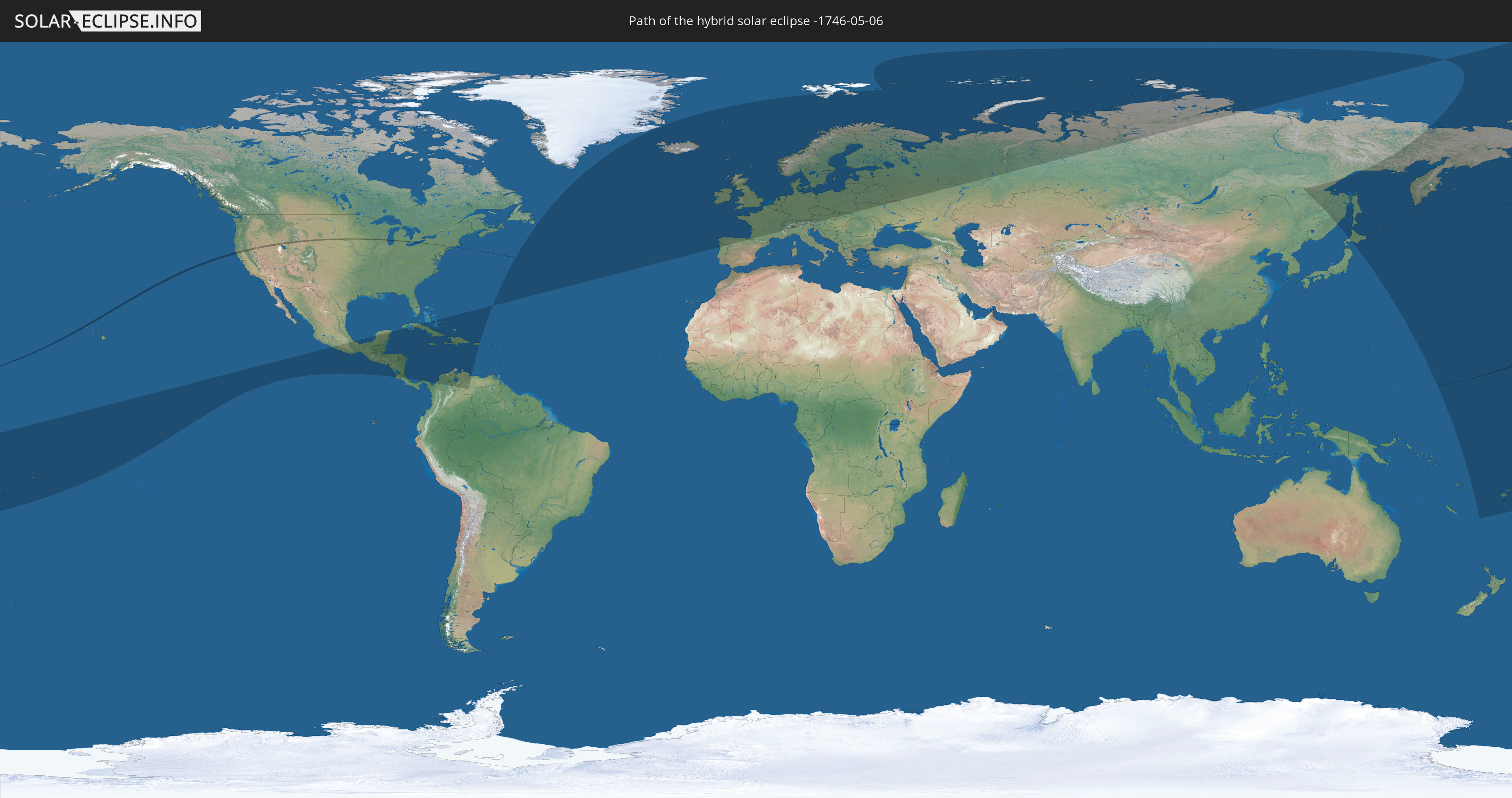
Die Sonnenfinsternis am 05/06/-1746 kann man in 41 Ländern als partielle Sonnenfinsternis beobachten.
Der Finsternispfad verläuft durch 3 Länder. Nur in diesen Ländern ist sie als hybrid Sonnenfinsternis zu sehen.
In den folgenden Ländern ist die Sonnenfinsternis hybrid zu sehen
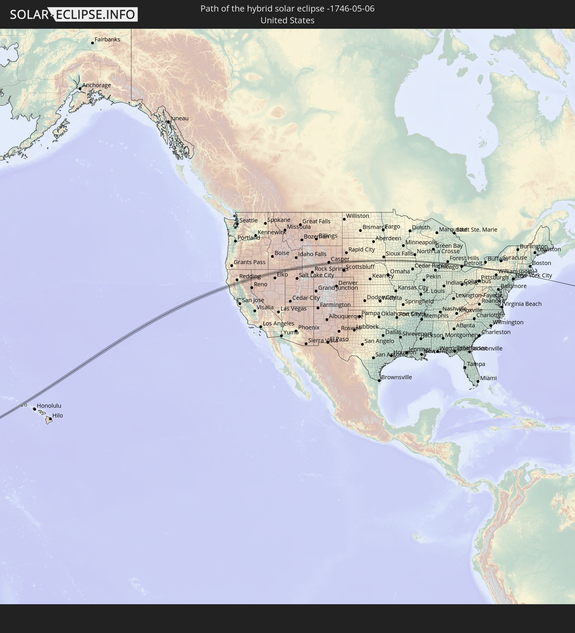 United States
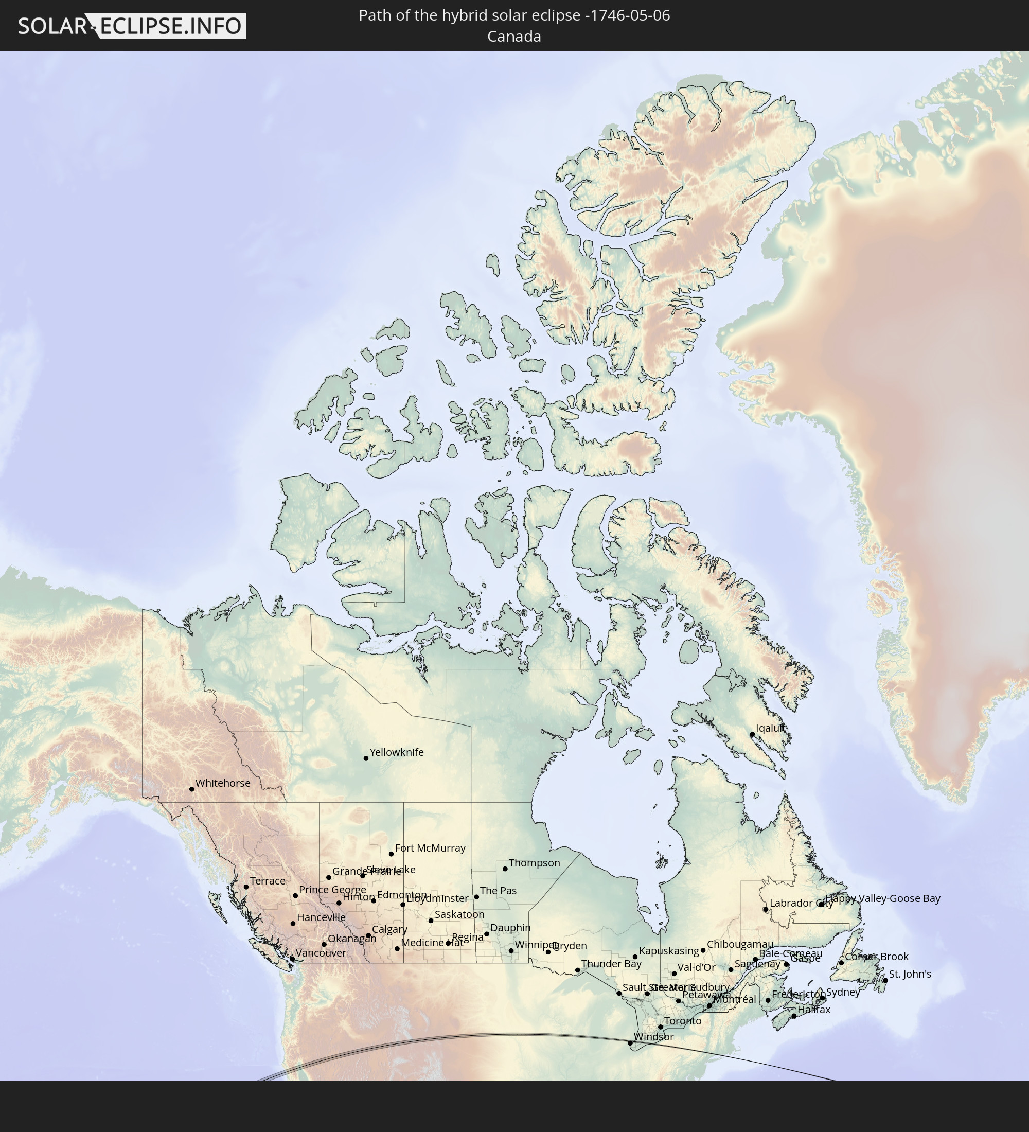 Canada
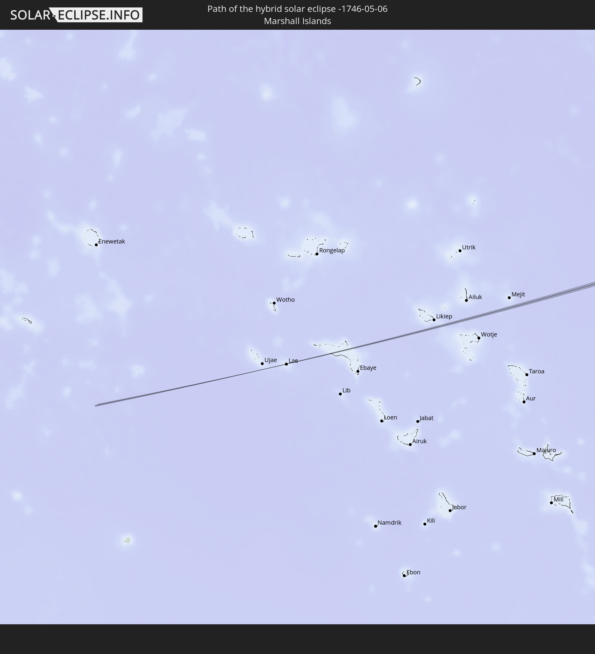 Marshall Islands
In den folgenden Ländern ist die Sonnenfinsternis partiell zu sehen
 Fiji
Fiji
 Russia
 United States
 United States Minor Outlying Islands
 Wallis and Futuna
 Tonga
Tonga
 Kiribati
 Samoa
Samoa
 Tokelau
 American Samoa
 Cook Islands
 Canada
 Mexico
 Greenland
 Guatemala
 El Salvador
 Honduras
 Belize
 Nicaragua
 Costa Rica
 Cuba
Cuba
 Panama
 Colombia
 Cayman Islands
 The Bahamas
 Jamaica
 Haiti
Haiti
 Venezuela
 Turks and Caicos Islands
 Dominican Republic
 Aruba
Aruba
 Puerto Rico
 Bermuda
 Saint Pierre and Miquelon
 Svalbard and Jan Mayen
 Japan
Japan
 Solomon Islands
 New Caledonia
 Marshall Islands
 Nauru
Nauru
 Tuvalu
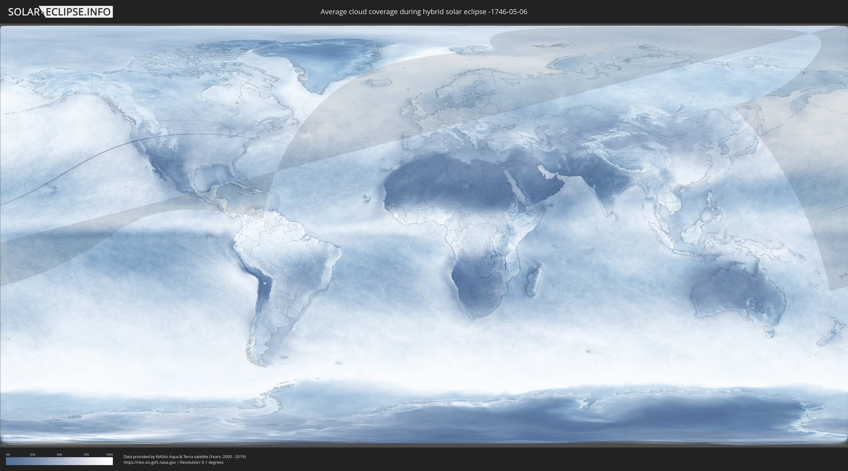
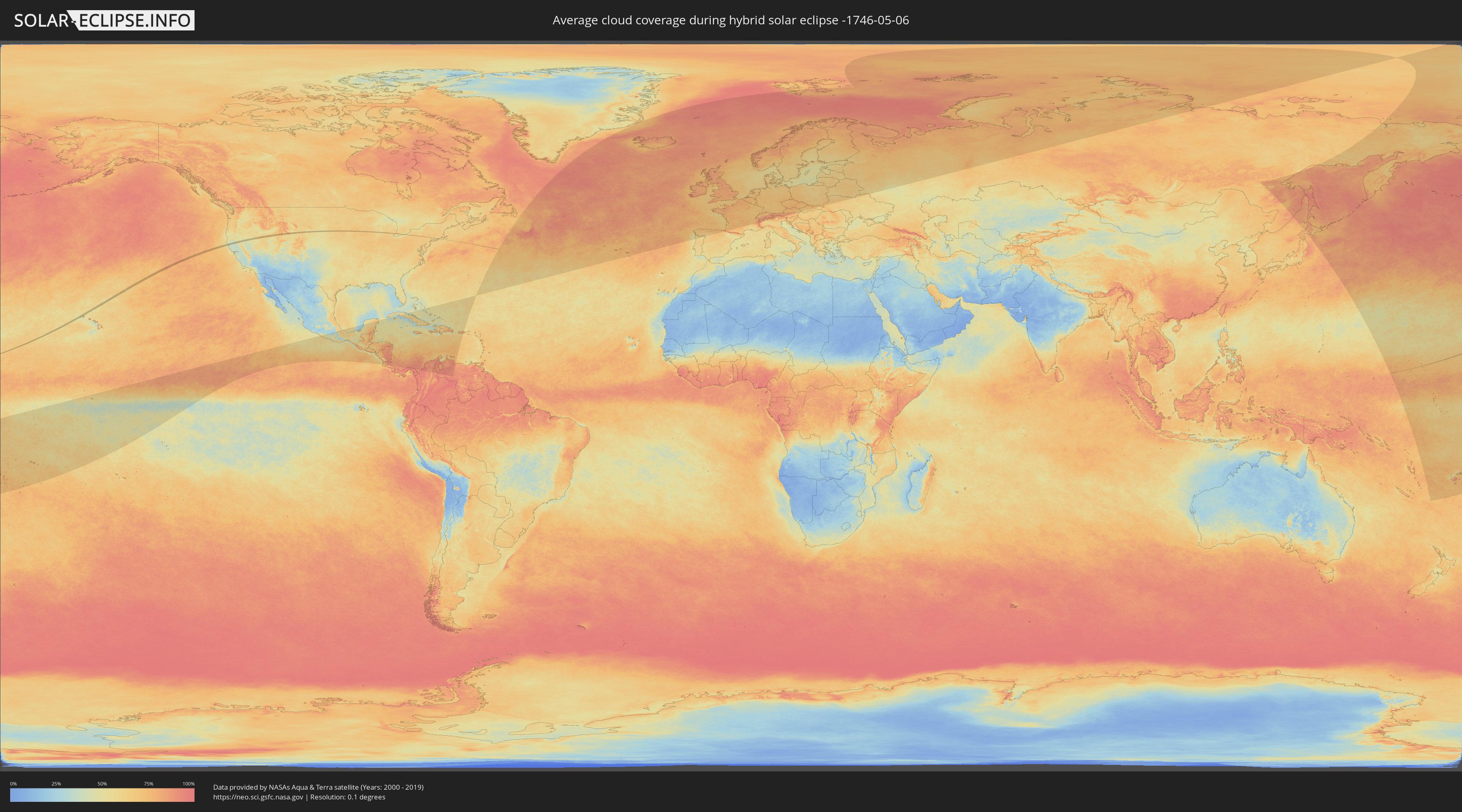
How will be the weather during the hybrid solar eclipse on 05/06/-1746?
Where is the best place to see the hybrid solar eclipse of 05/06/-1746?
The following maps show the average cloud coverage for the day of the hybrid solar eclipse.
With the help of these maps, it is possible to find the place along the eclipse path, which has the best
chance of a cloudless sky.
Nevertheless, you should consider local circumstances and inform about the weather of your chosen
observation site.
The data is provided by NASAs satellites
AQUA and TERRA.
The cloud maps are averaged over a period of 19 years (2000 - 2019).
Detailed country maps
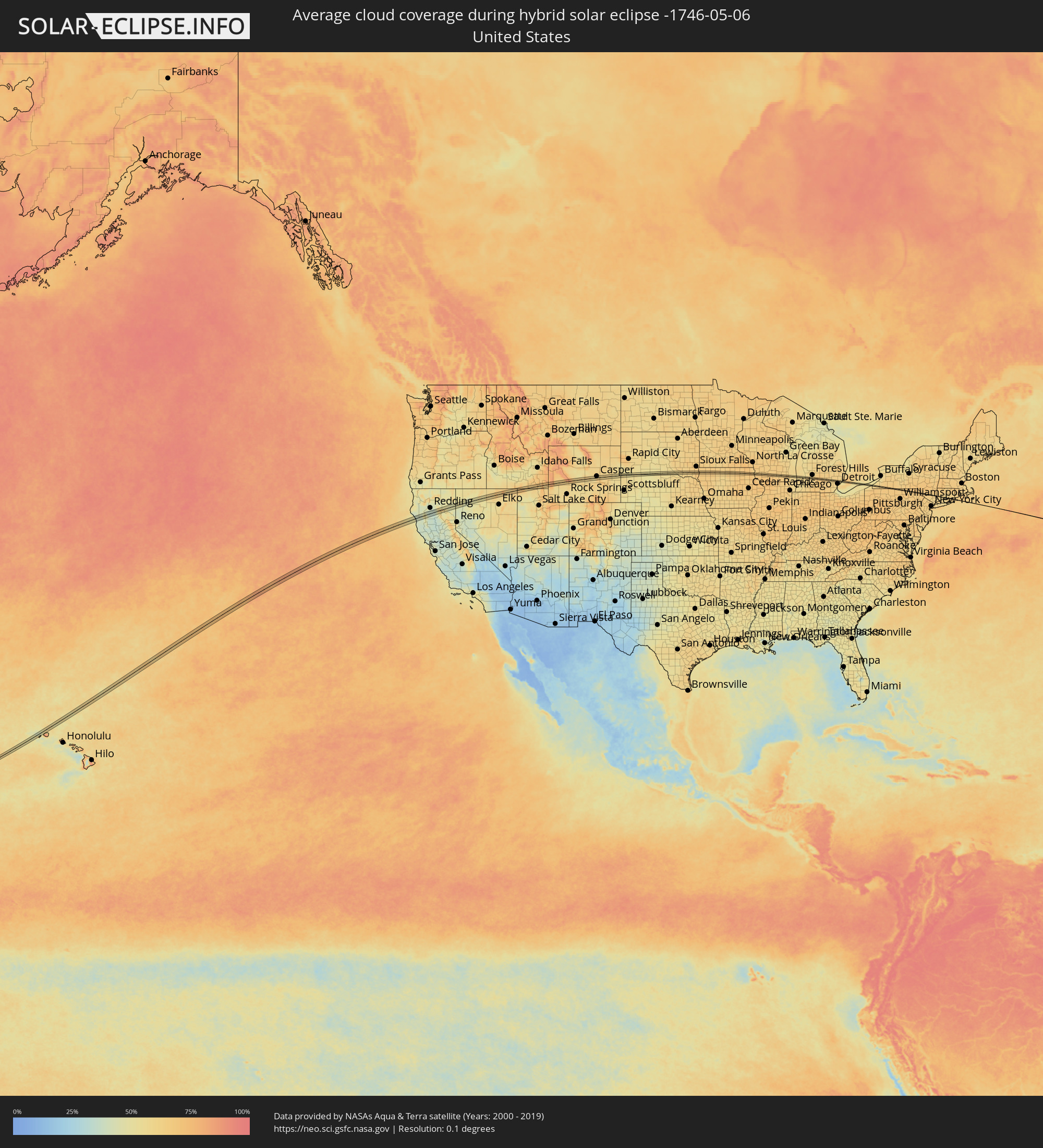 United States
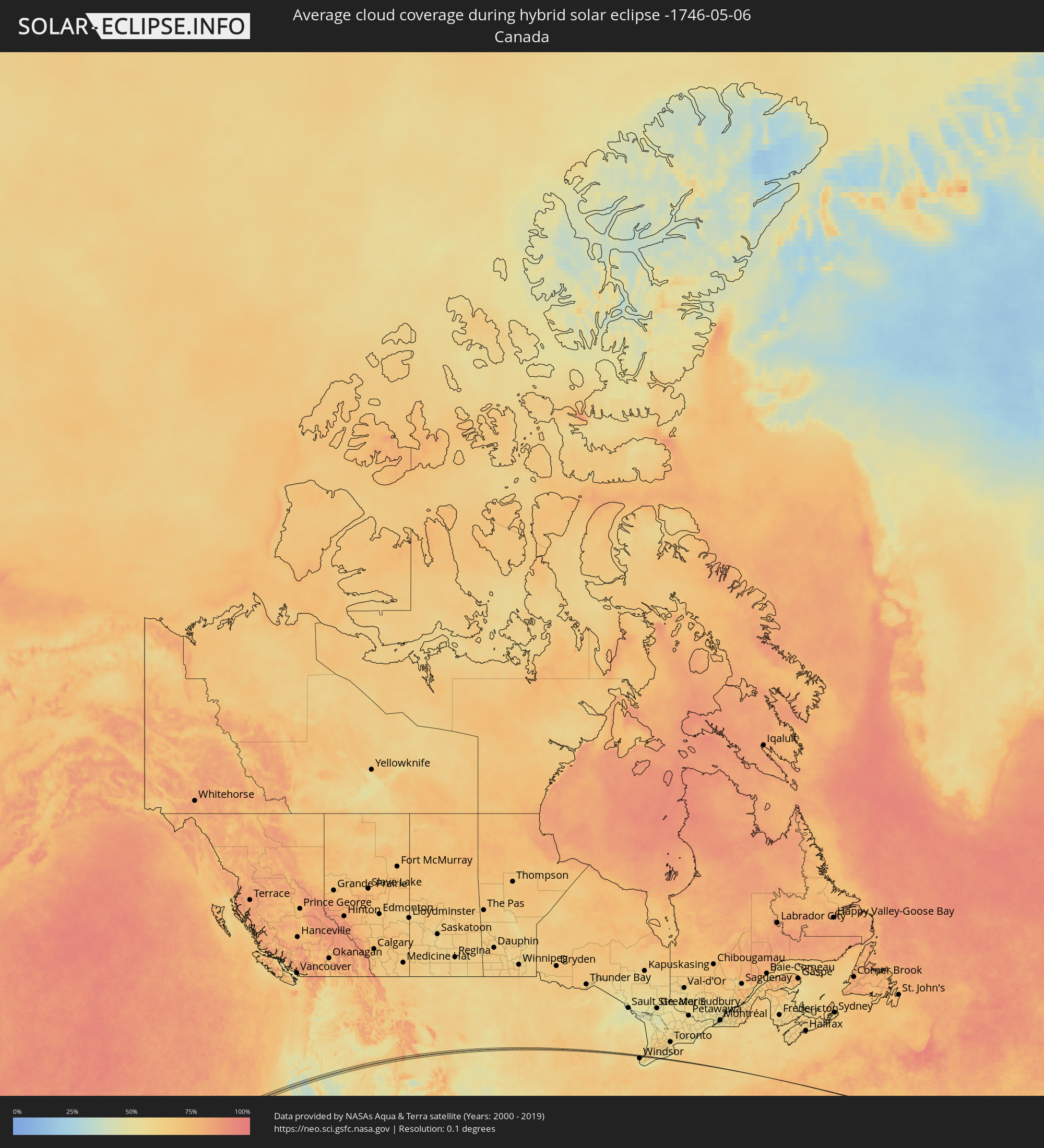 Canada
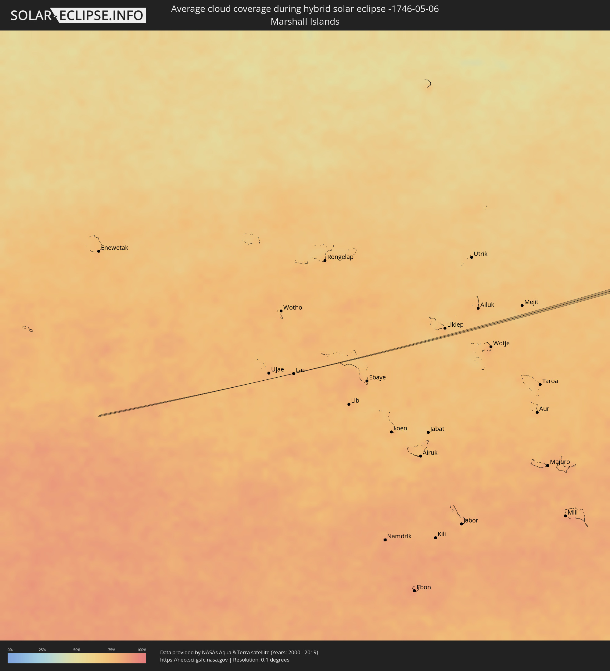 Marshall Islands
Cities inside the path of the eclipse
The following table shows all locations with a population of more than 5,000 inside the eclipse path. Cities which have more than 100,000 inhabitants are marked bold. A click at the locations opens a detailed map.
| City | Type | Eclipse duration | Local time of max. eclipse | Distance to central line | Ø Cloud coverage |
|
Red Bluff, California
|
total | - | 13:20:46 UTC-08:00 | 5 km | 34% |
|
Susanville, California
|
total | - | 13:23:58 UTC-08:00 | 20 km | 47% |
|
Preston, Idaho
|
total | - | 14:39:51 UTC-07:00 | 9 km | 59% |
|
Casper, Wyoming
|
total | - | 14:48:07 UTC-07:00 | 11 km | 60% |
|
Douglas, Wyoming
|
total | - | 14:49:30 UTC-07:00 | 9 km | 62% |
|
Sioux Center, Iowa
|
total | - | 16:00:33 UTC-06:00 | 8 km | 67% |
|
Sheldon, Iowa
|
total | - | 16:00:48 UTC-06:00 | 4 km | 66% |
|
Spencer, Iowa
|
total | - | 16:01:34 UTC-06:00 | 0 km | 67% |
|
Algona, Iowa
|
total | - | 16:02:31 UTC-06:00 | 7 km | 62% |
|
Clear Lake, Iowa
|
total | - | 16:03:17 UTC-06:00 | 3 km | 66% |
|
Mason City, Iowa
|
total | - | 16:03:26 UTC-06:00 | 5 km | 65% |
|
Charles City, Iowa
|
total | - | 16:04:00 UTC-06:00 | 3 km | 65% |
|
Prairie du Chien, Wisconsin
|
total | - | 16:05:23 UTC-06:00 | 0 km | 63% |
|
Mount Horeb, Wisconsin
|
total | - | 16:06:35 UTC-06:00 | 2 km | 67% |
|
Verona, Wisconsin
|
total | - | 16:06:46 UTC-06:00 | 1 km | 67% |
|
Fitchburg, Wisconsin
|
total | - | 16:06:51 UTC-06:00 | 2 km | 67% |
|
Oregon, Wisconsin
|
total | - | 16:06:57 UTC-06:00 | 5 km | 67% |
|
McFarland, Wisconsin
|
total | - | 16:06:56 UTC-06:00 | 5 km | 65% |
|
Stoughton, Wisconsin
|
total | - | 16:07:05 UTC-06:00 | 5 km | 67% |
|
Fort Atkinson, Wisconsin
|
total | - | 16:07:22 UTC-06:00 | 2 km | 63% |
|
Jefferson, Wisconsin
|
total | - | 16:07:20 UTC-06:00 | 7 km | 63% |
|
Mukwonago, Wisconsin
|
total | - | 16:07:49 UTC-06:00 | 6 km | 65% |
|
Tichigan, Wisconsin
|
total | - | 16:07:57 UTC-06:00 | 9 km | 64% |
|
Wind Lake, Wisconsin
|
total | - | 16:07:59 UTC-06:00 | 9 km | 64% |
|
Muskego, Wisconsin
|
total | - | 16:07:56 UTC-06:00 | 0 km | 64% |
|
New Berlin, Wisconsin
|
total | - | 16:07:53 UTC-06:00 | 8 km | 65% |
|
Hales Corners, Wisconsin
|
total | - | 16:07:58 UTC-06:00 | 4 km | 64% |
|
Franklin, Wisconsin
|
total | - | 16:08:01 UTC-06:00 | 1 km | 64% |
|
Greenfield, Wisconsin
|
total | - | 16:07:58 UTC-06:00 | 7 km | 65% |
|
Greendale, Wisconsin
|
total | - | 16:08:00 UTC-06:00 | 5 km | 64% |
|
Saint Francis, Wisconsin
|
total | - | 16:08:04 UTC-06:00 | 8 km | 64% |
|
Oak Creek, Wisconsin
|
total | - | 16:08:09 UTC-06:00 | 1 km | 63% |
|
Cudahy, Wisconsin
|
total | - | 16:08:05 UTC-06:00 | 8 km | 64% |
|
South Milwaukee, Wisconsin
|
total | - | 16:08:08 UTC-06:00 | 2 km | 63% |
|
Holland, Michigan
|
total | - | 17:09:30 UTC-05:00 | 1 km | 61% |
|
Zeeland, Michigan
|
total | - | 17:09:32 UTC-05:00 | 4 km | 63% |
|
Byron Center, Michigan
|
total | - | 17:09:44 UTC-05:00 | 7 km | 61% |
|
Waverly, Michigan
|
total | - | 17:10:31 UTC-05:00 | 8 km | 67% |
|
Lansing, Michigan
|
total | - | 17:10:34 UTC-05:00 | 8 km | 67% |
|
Holt, Michigan
|
total | - | 17:10:41 UTC-05:00 | 2 km | 68% |
|
Okemos, Michigan
|
total | - | 17:10:39 UTC-05:00 | 8 km | 65% |
|
Howell, Michigan
|
total | - | 17:11:04 UTC-05:00 | 1 km | 62% |
|
Milford, Michigan
|
total | - | 17:11:17 UTC-05:00 | 1 km | 61% |
|
Wixom, Michigan
|
total | - | 17:11:23 UTC-05:00 | 6 km | 61% |
|
Walled Lake, Michigan
|
total | - | 17:11:24 UTC-05:00 | 4 km | 61% |
|
West Bloomfield Township, Michigan
|
total | - | 17:11:26 UTC-05:00 | 0 km | 62% |
|
Beverly Hills, Michigan
|
total | - | 17:11:34 UTC-05:00 | 3 km | 62% |
|
Birmingham, Michigan
|
total | - | 17:11:33 UTC-05:00 | 1 km | 62% |
|
Berkley, Michigan
|
total | - | 17:11:37 UTC-05:00 | 5 km | 62% |
|
Troy, Michigan
|
total | - | 17:11:32 UTC-05:00 | 6 km | 63% |
|
Clawson, Michigan
|
total | - | 17:11:36 UTC-05:00 | 2 km | 62% |
|
Royal Oak, Michigan
|
total | - | 17:11:39 UTC-05:00 | 6 km | 62% |
|
Madison Heights, Michigan
|
total | - | 17:11:41 UTC-05:00 | 6 km | 62% |
|
Sterling Heights, Michigan
|
total | - | 17:11:38 UTC-05:00 | 5 km | 63% |
|
Warren, Michigan
|
total | - | 17:11:44 UTC-05:00 | 7 km | 61% |
|
Center Line, Michigan
|
total | - | 17:11:43 UTC-05:00 | 6 km | 61% |
|
Eastpointe, Michigan
|
total | - | 17:11:47 UTC-05:00 | 7 km | 61% |
|
Fraser, Michigan
|
total | - | 17:11:43 UTC-05:00 | 1 km | 58% |
|
Roseville, Michigan
|
total | - | 17:11:46 UTC-05:00 | 4 km | 58% |
|
Clinton, Michigan
|
total | - | 17:11:41 UTC-05:00 | 7 km | 59% |
|
Saint Clair Shores, Michigan
|
total | - | 17:11:47 UTC-05:00 | 3 km | 58% |
|
Olean, New York
|
total | - | 17:14:25 UTC-05:00 | 0 km | 67% |
|
Walden, New York
|
total | - | 17:16:27 UTC-05:00 | 1 km | 65% |
|
Orange Lake, New York
|
total | - | 17:16:30 UTC-05:00 | 0 km | 63% |
|
Newburgh, New York
|
total | - | 17:16:33 UTC-05:00 | 3 km | 61% |
|
Beacon, New York
|
total | - | 17:16:34 UTC-05:00 | 2 km | 61% |
|
Lake Carmel, New York
|
total | - | 17:16:42 UTC-05:00 | 2 km | 62% |
|
Seymour, Connecticut
|
total | - | 17:16:55 UTC-05:00 | 1 km | 60% |
|
Hamden, Connecticut
|
total | - | 17:16:58 UTC-05:00 | 2 km | 59% |
|
North Haven, Connecticut
|
total | - | 17:16:59 UTC-05:00 | 2 km | 59% |
|
Old Saybrook, Connecticut
|
total | - | 17:17:12 UTC-05:00 | 1 km | 64% |