Total solar eclipse of 06/05/-1822
| Day of week: | Wednesday |
| Maximum duration of eclipse: | 05m20s |
| Maximum width of eclipse path: | 246 km |
| Saros cycle: | 8 |
| Coverage: | 100% |
| Magnitude: | 1.0686 |
| Gamma: | 0.4148 |
Wo kann man die Sonnenfinsternis vom 06/05/-1822 sehen?
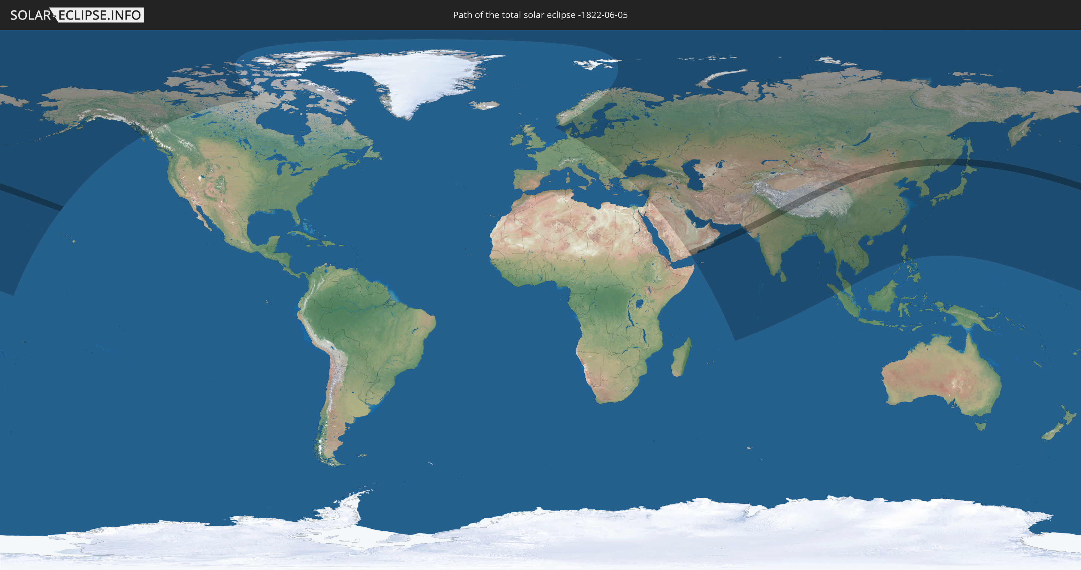
Die Sonnenfinsternis am 06/05/-1822 kann man in 71 Ländern als partielle Sonnenfinsternis beobachten.
Der Finsternispfad verläuft durch 9 Länder. Nur in diesen Ländern ist sie als total Sonnenfinsternis zu sehen.
In den folgenden Ländern ist die Sonnenfinsternis total zu sehen
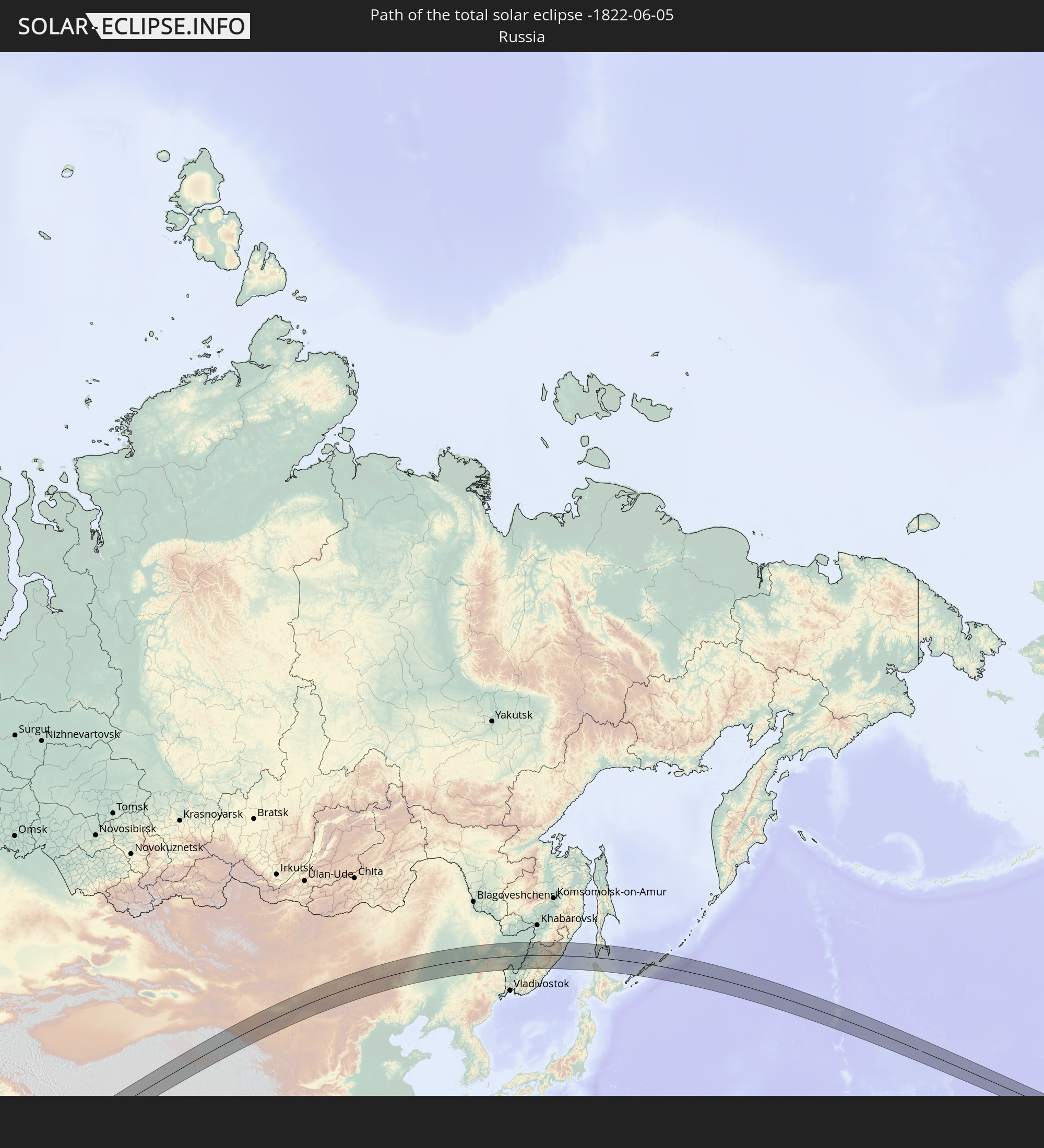 Russia
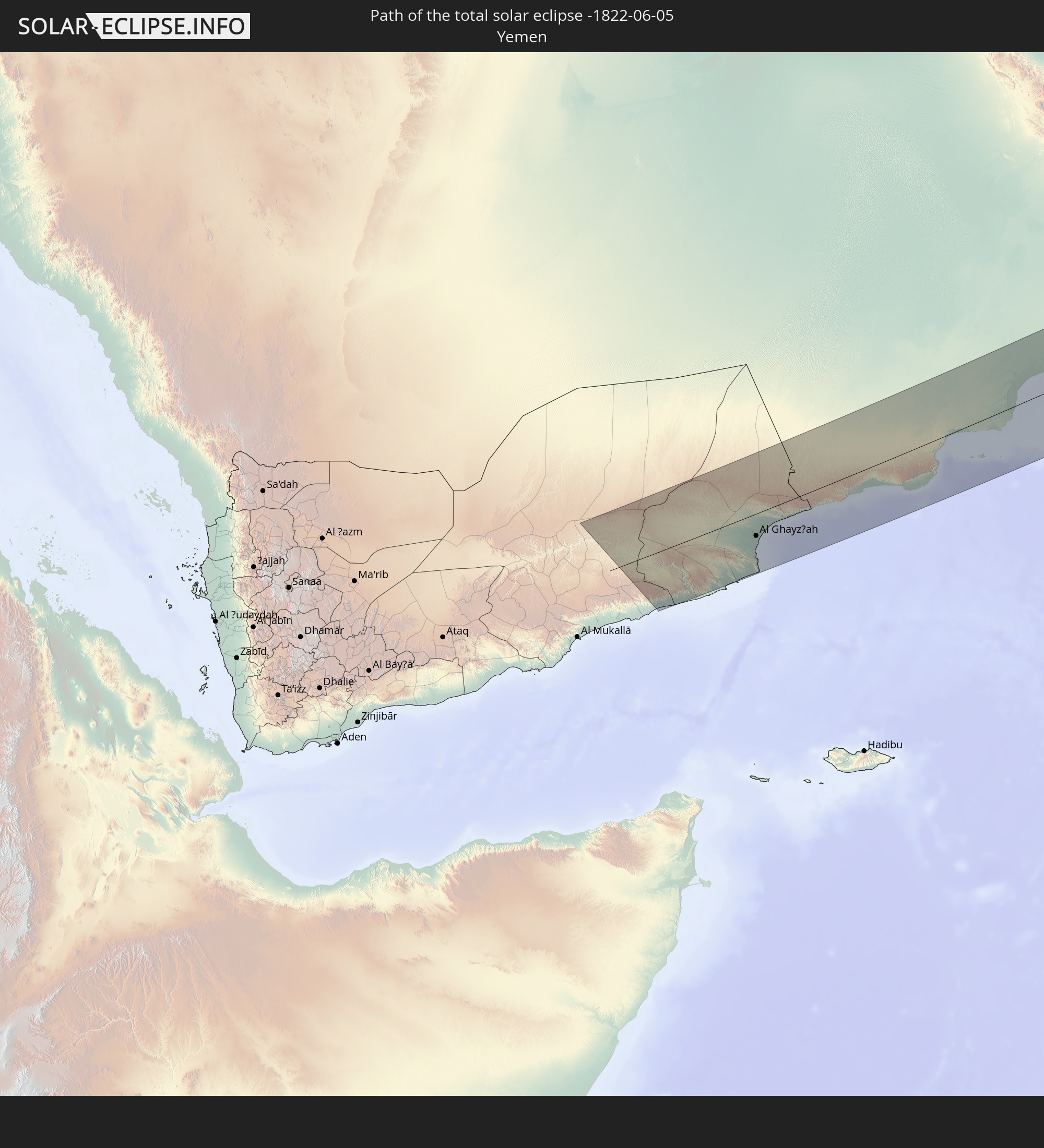 Yemen
Yemen
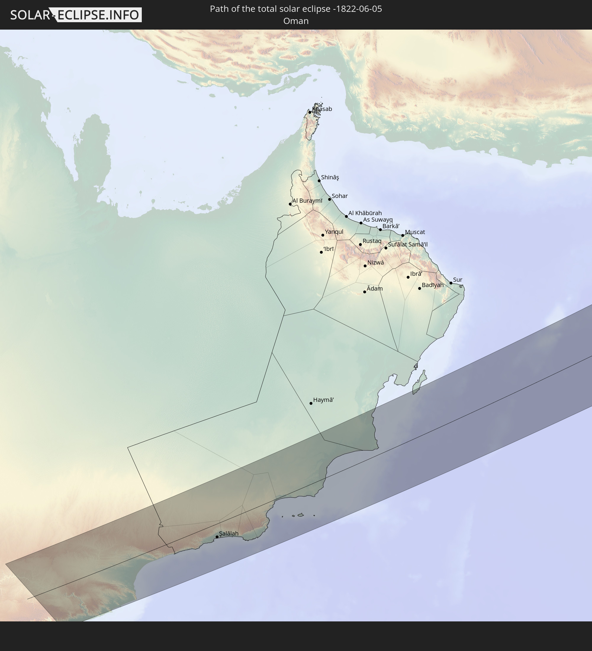 Oman
Oman
 Pakistan
 India
India
 China
China
 Nepal
Nepal
 Mongolia
 Japan
Japan
In den folgenden Ländern ist die Sonnenfinsternis partiell zu sehen
 Russia
 United States
 United States Minor Outlying Islands
 Canada
 Svalbard and Jan Mayen
 Norway
 Germany
 Denmark
 Sweden
 Czechia
 Poland
 Hungary
 Slovakia
 Åland Islands
 Romania
 Finland
 Lithuania
 Latvia
 Estonia
 Ukraine
 Bulgaria
 Belarus
 Turkey
 Moldova
 Saudi Arabia
 Jordan
 Lebanon
 Syria
Syria
 Iraq
Iraq
 Georgia
 Yemen
Yemen
 Armenia
 Iran
Iran
 Azerbaijan
 Kazakhstan
 Kuwait
 Bahrain
 Qatar
Qatar
 United Arab Emirates
 Oman
Oman
 Turkmenistan
 Uzbekistan
 Afghanistan
 Pakistan
 Tajikistan
 India
India
 Kyrgyzstan
 British Indian Ocean Territory
 Maldives
 China
China
 Sri Lanka
 Nepal
Nepal
 Mongolia
 Bangladesh
 Bhutan
 Myanmar
 Indonesia
 Thailand
 Malaysia
 Laos
Laos
 Vietnam
 Cambodia
 Macau
Macau
 Hong Kong
 Taiwan
 Philippines
 Japan
Japan
 North Korea
 South Korea
 Northern Mariana Islands
 Marshall Islands
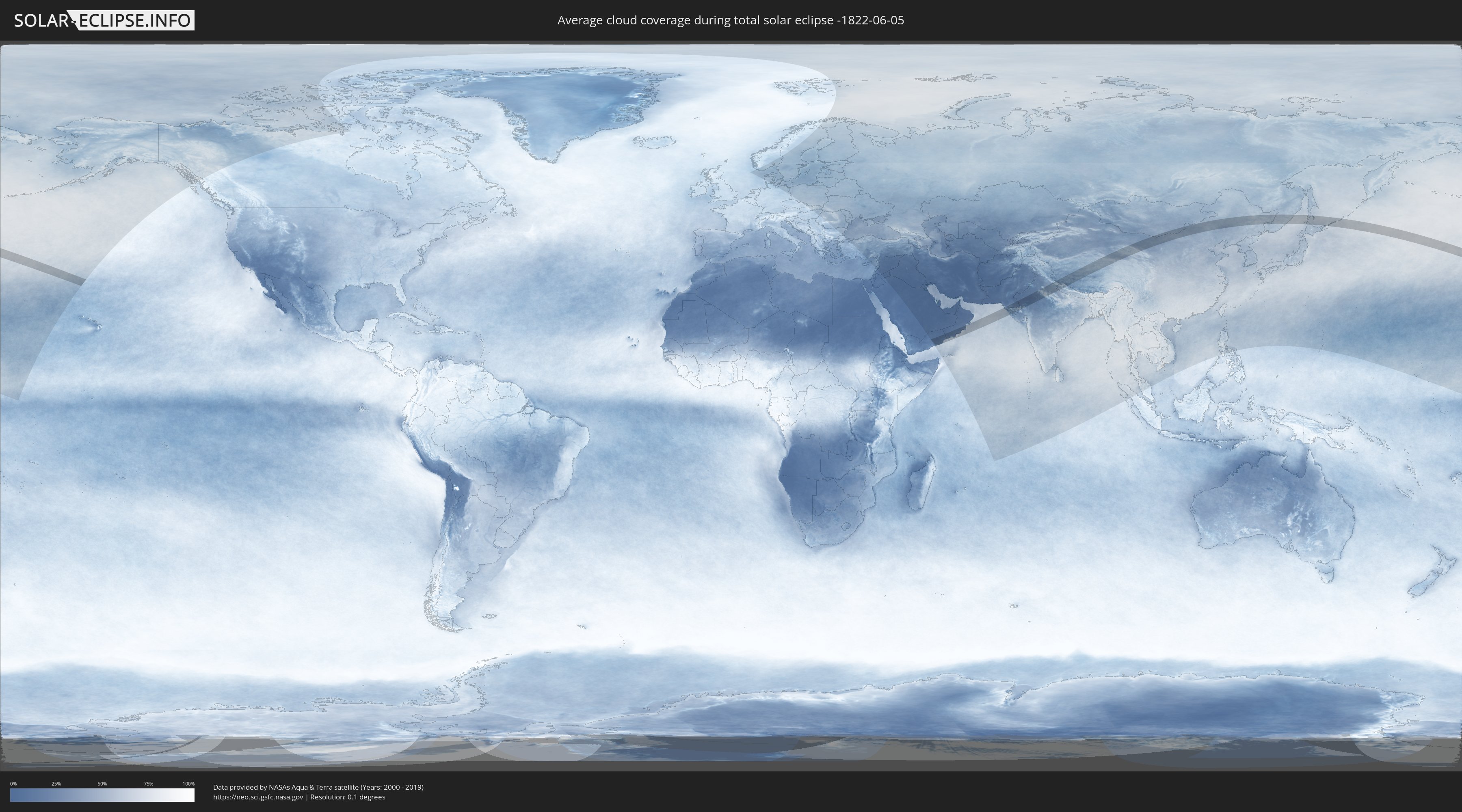
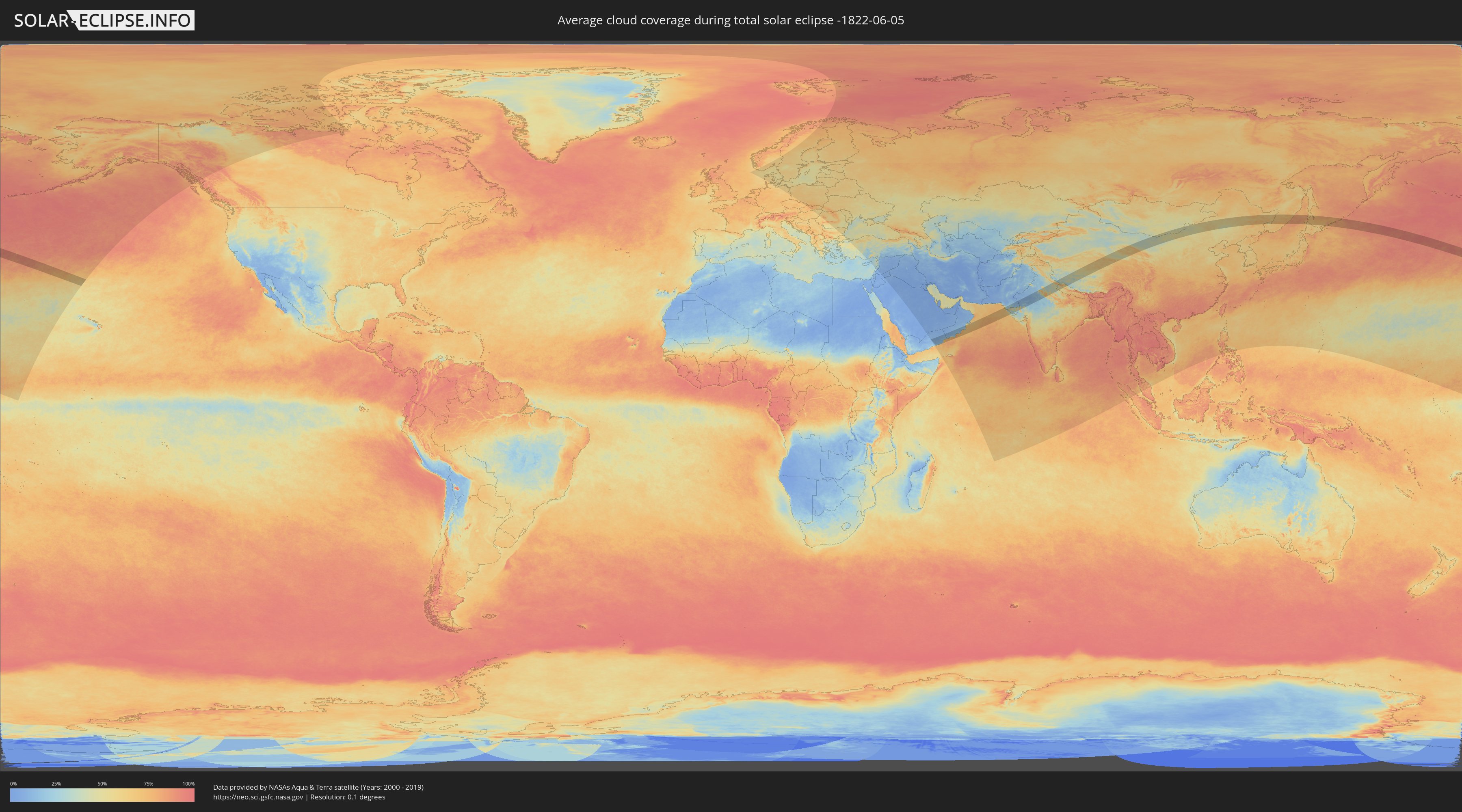
How will be the weather during the total solar eclipse on 06/05/-1822?
Where is the best place to see the total solar eclipse of 06/05/-1822?
The following maps show the average cloud coverage for the day of the total solar eclipse.
With the help of these maps, it is possible to find the place along the eclipse path, which has the best
chance of a cloudless sky.
Nevertheless, you should consider local circumstances and inform about the weather of your chosen
observation site.
The data is provided by NASAs satellites
AQUA and TERRA.
The cloud maps are averaged over a period of 19 years (2000 - 2019).
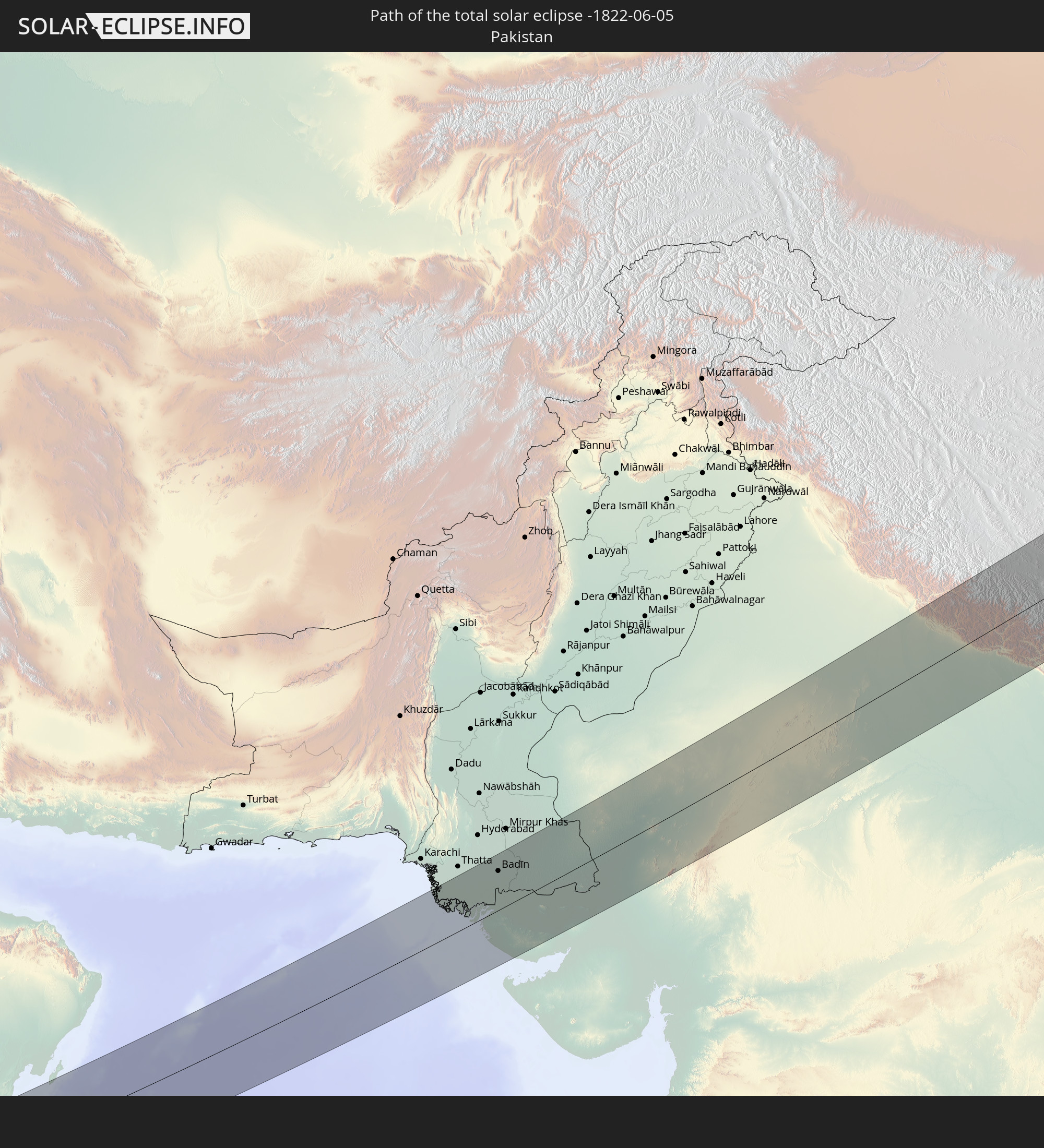
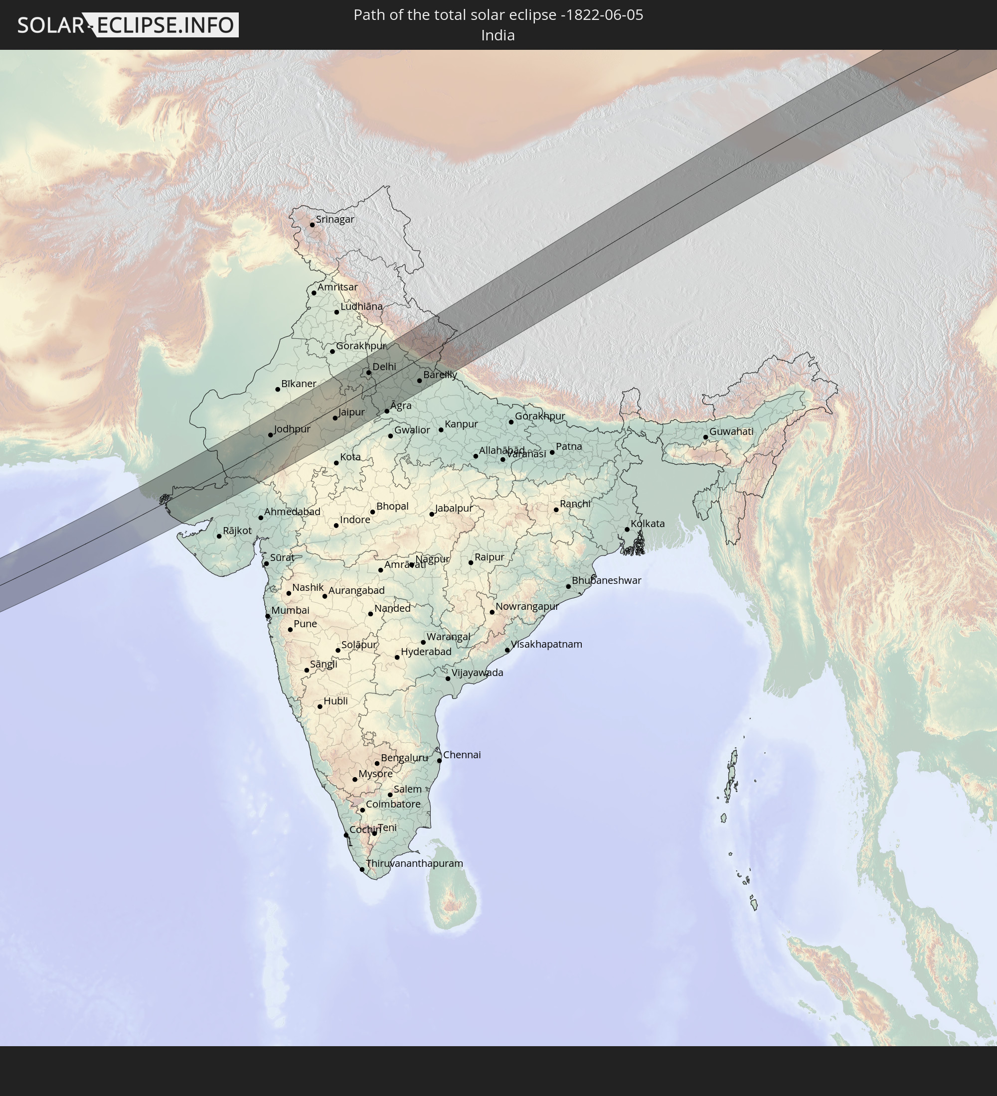
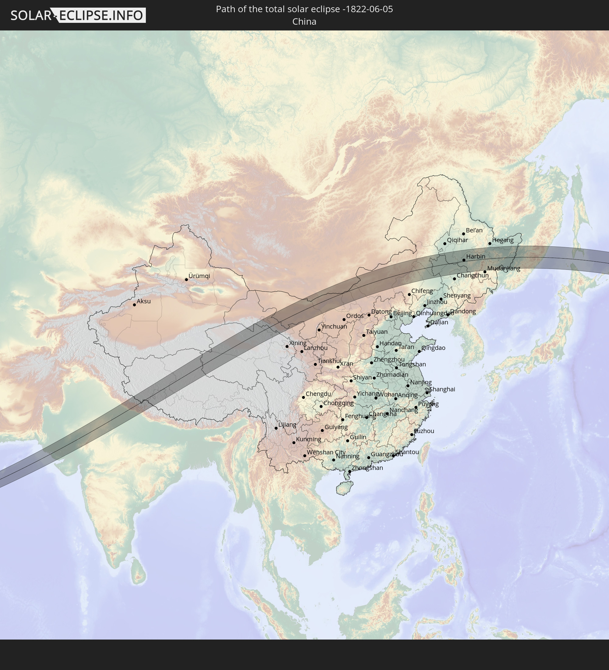
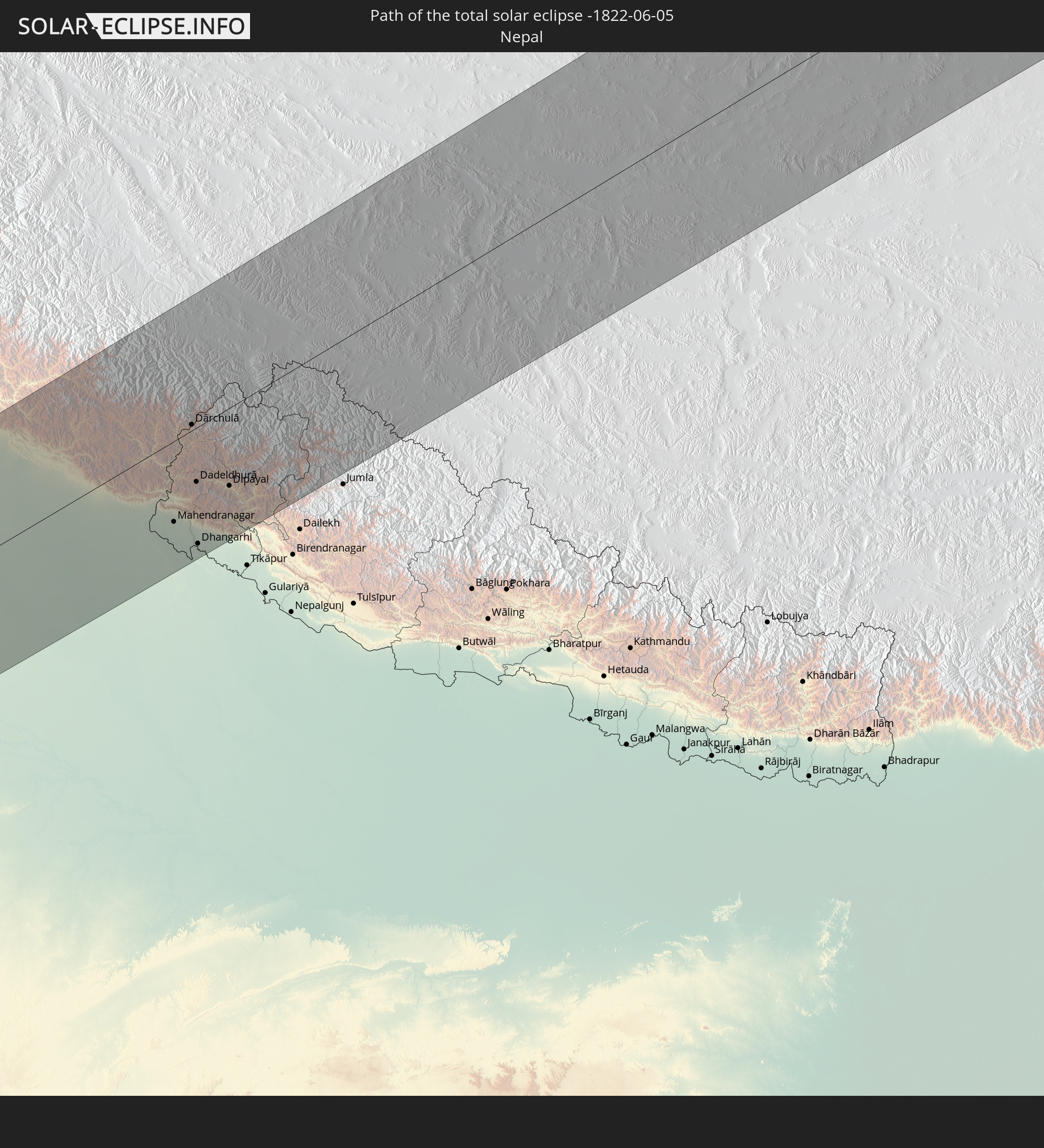
Detailed country maps
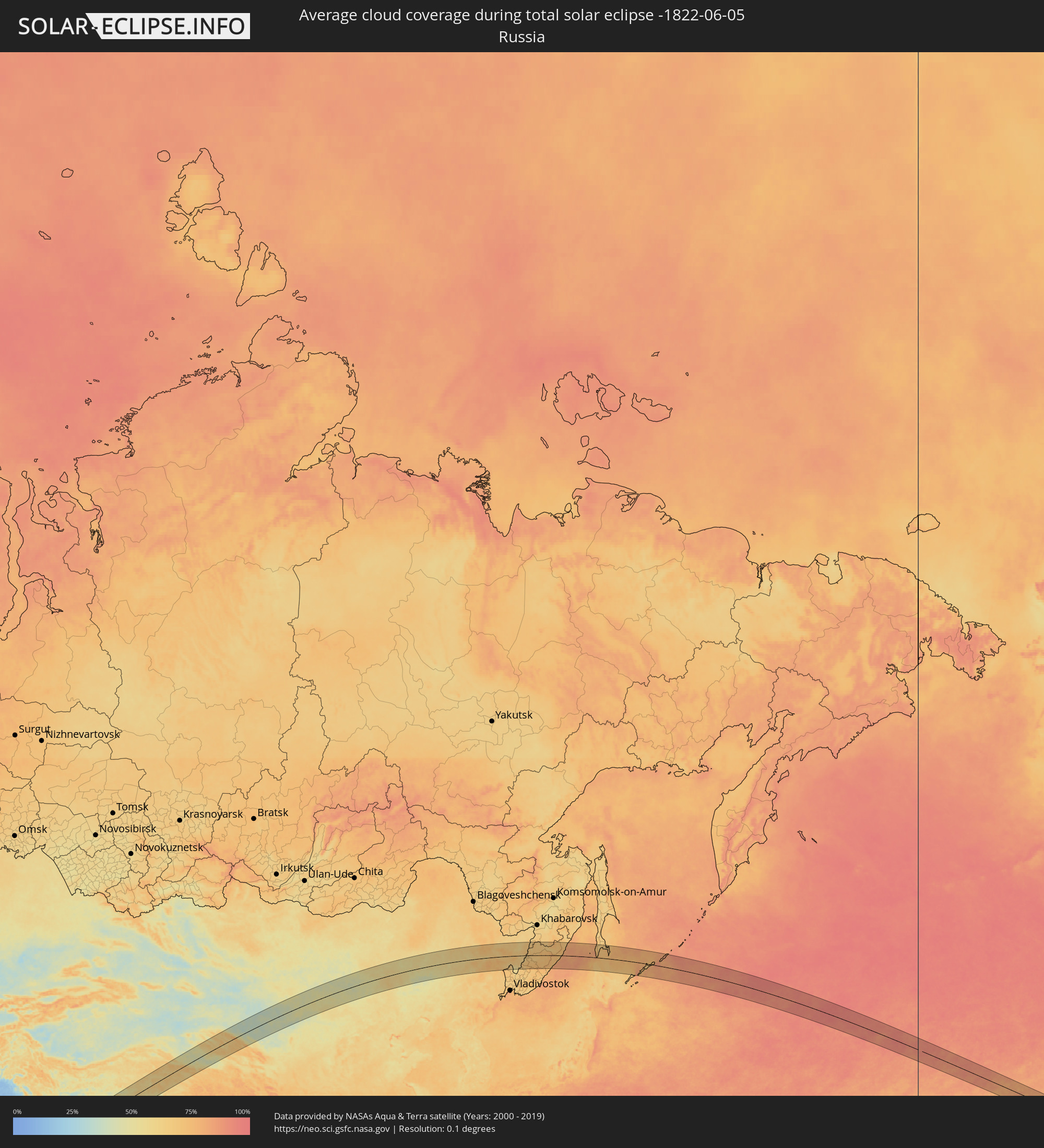 Russia
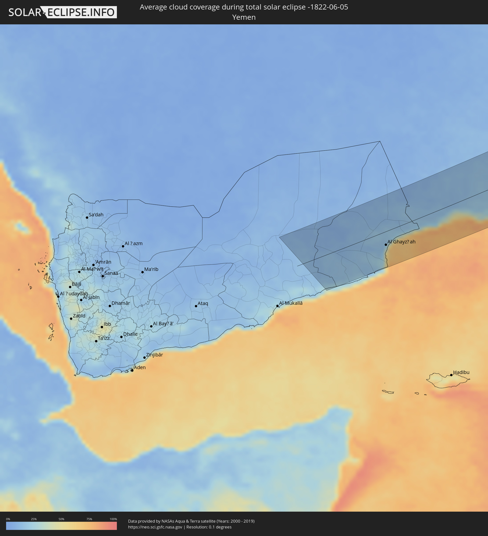 Yemen
Yemen
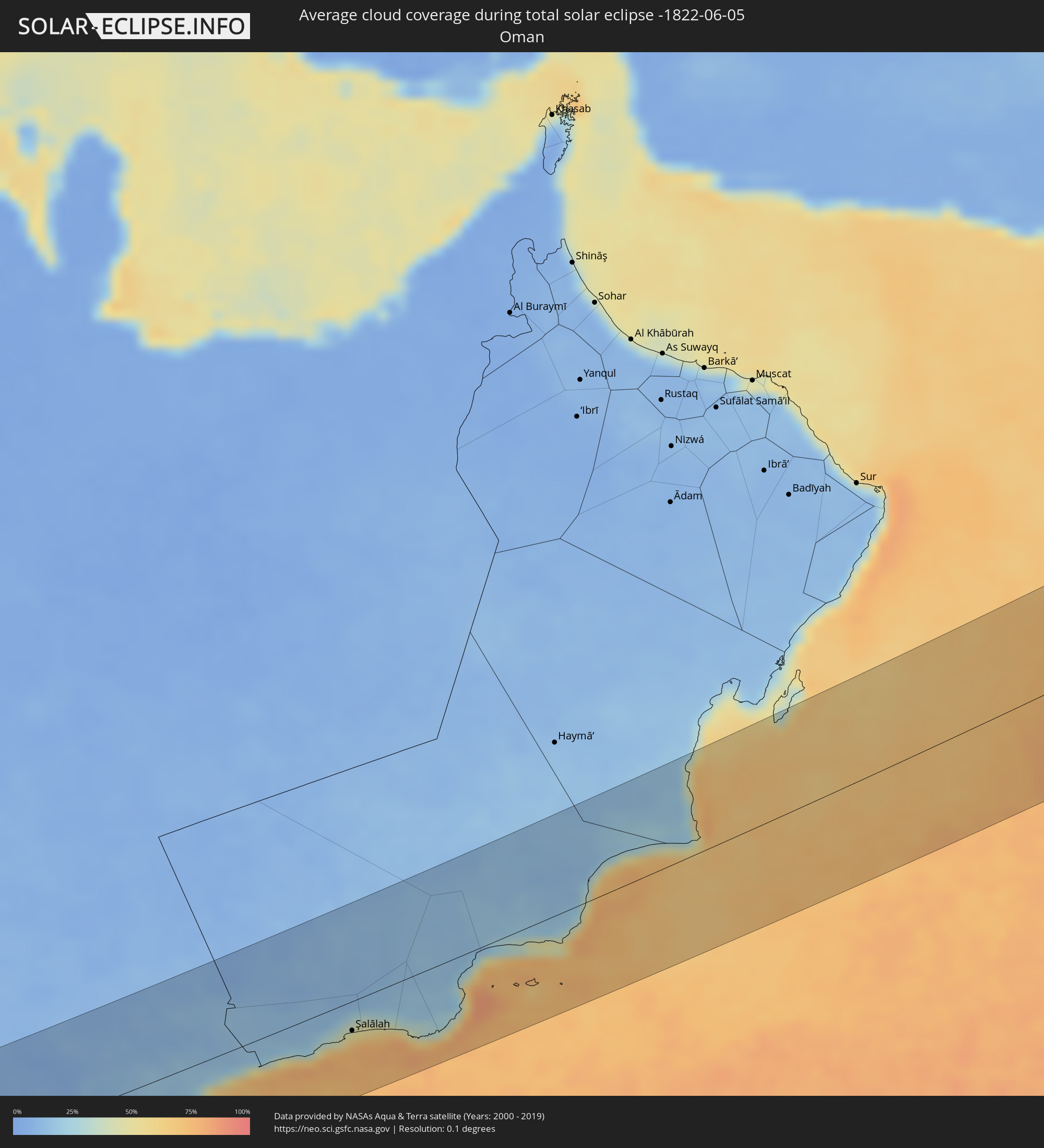 Oman
Oman
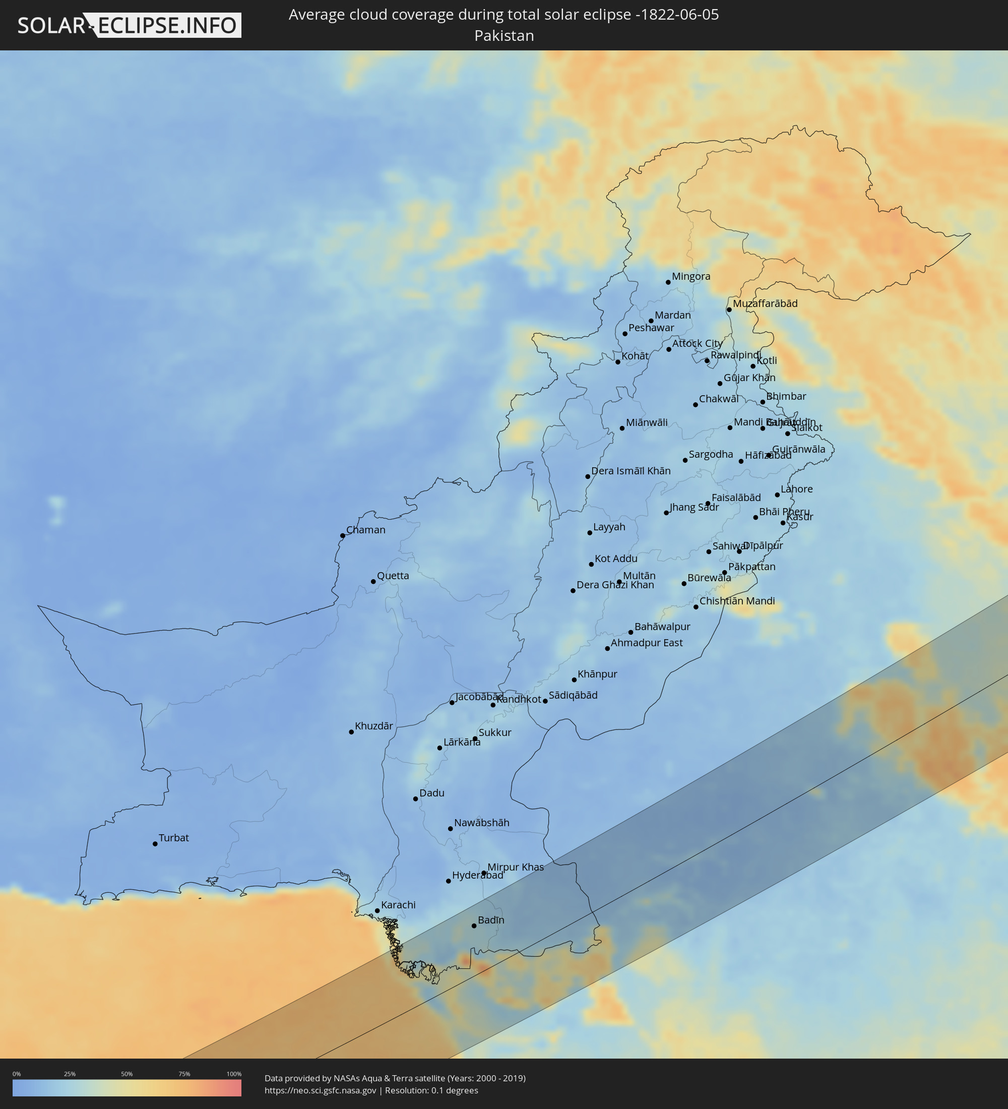 Pakistan
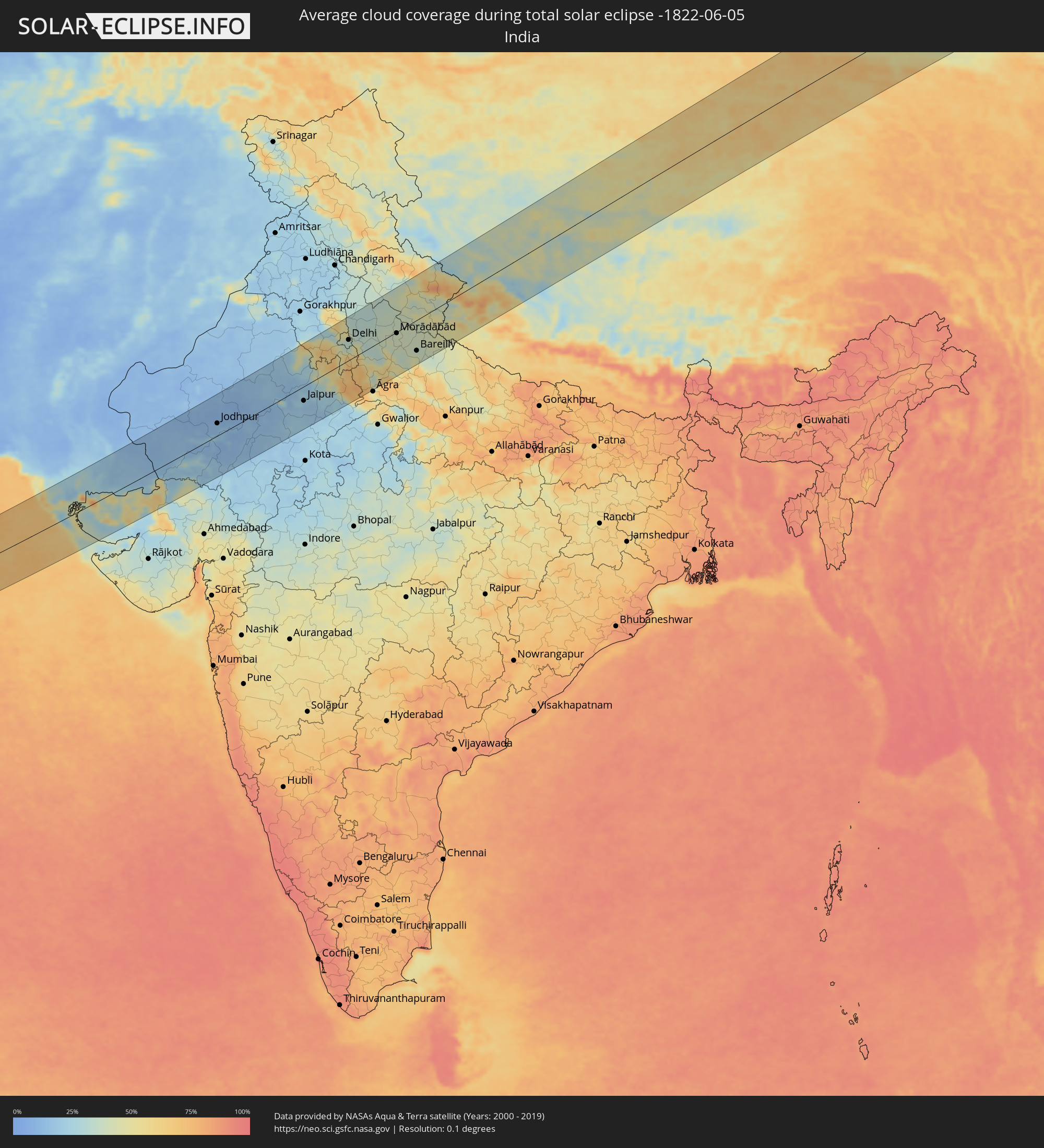 India
India
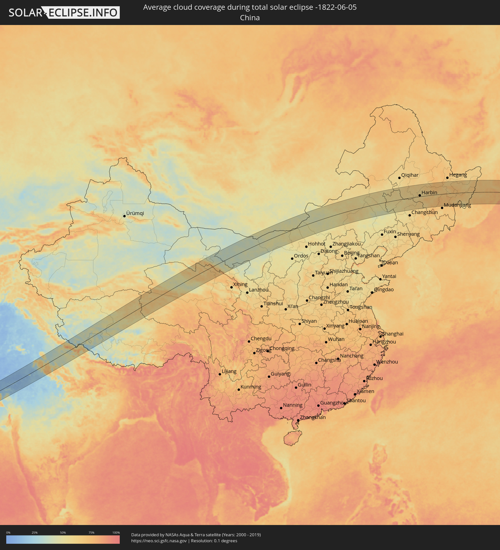 China
China
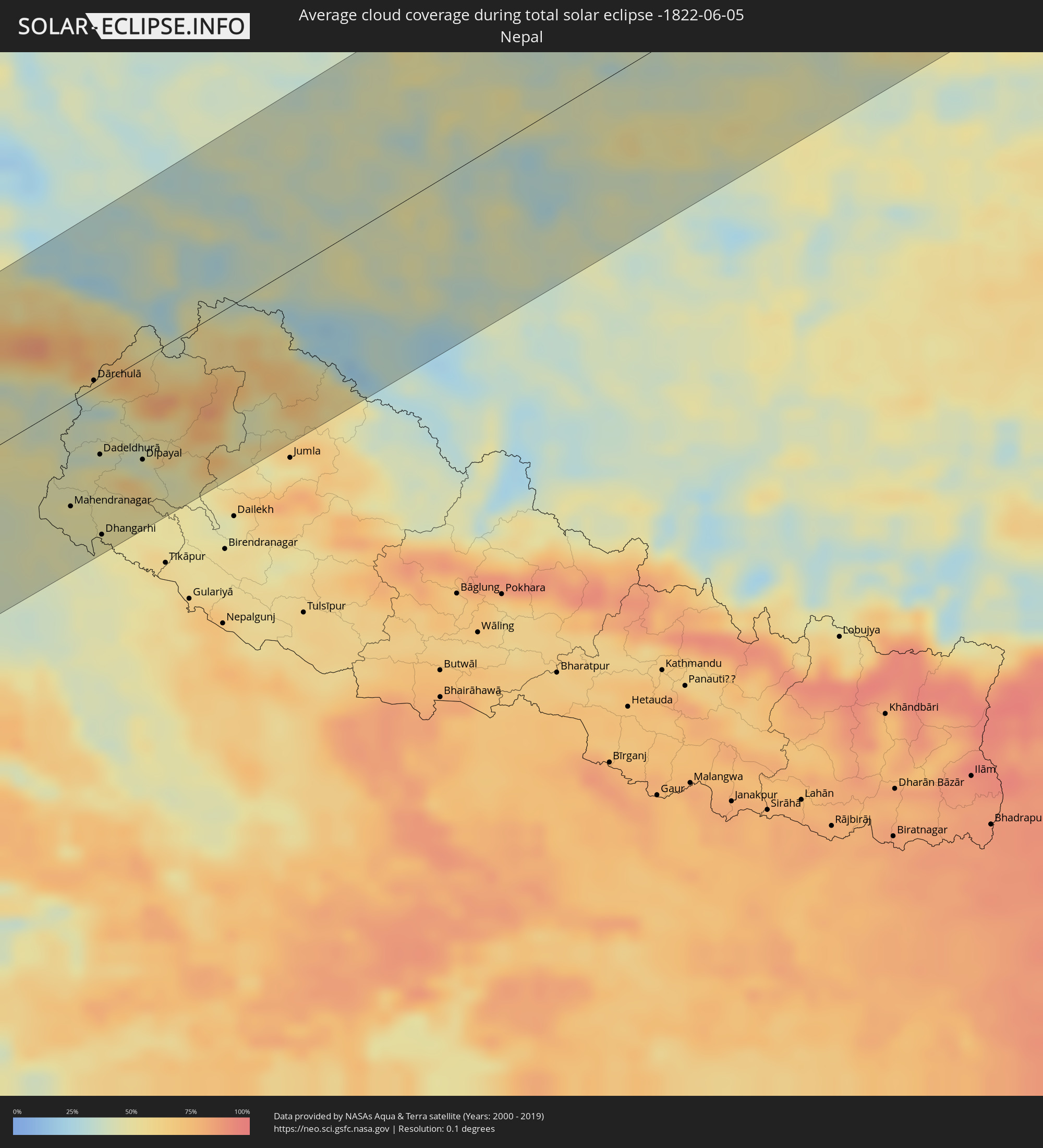 Nepal
Nepal
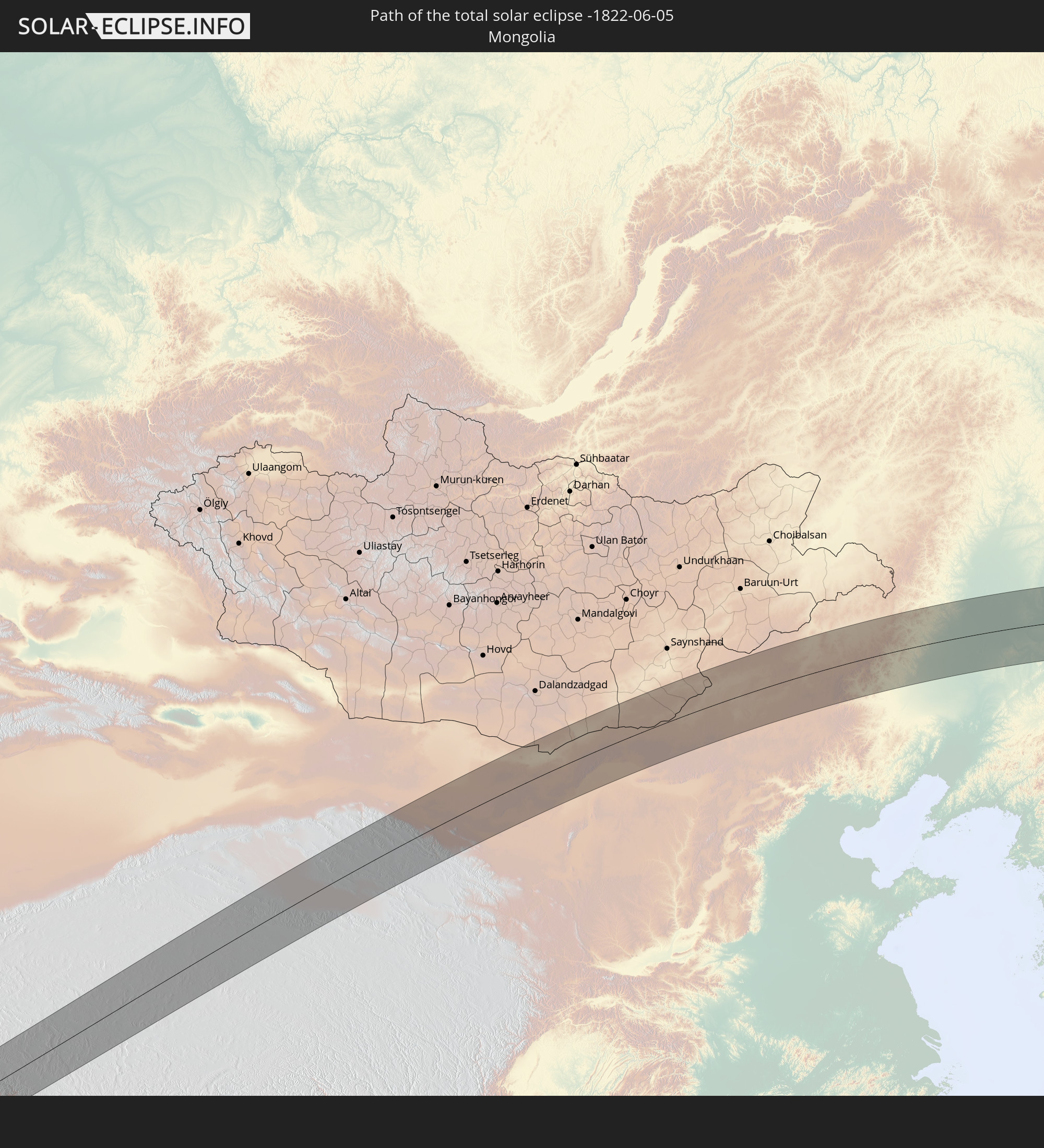
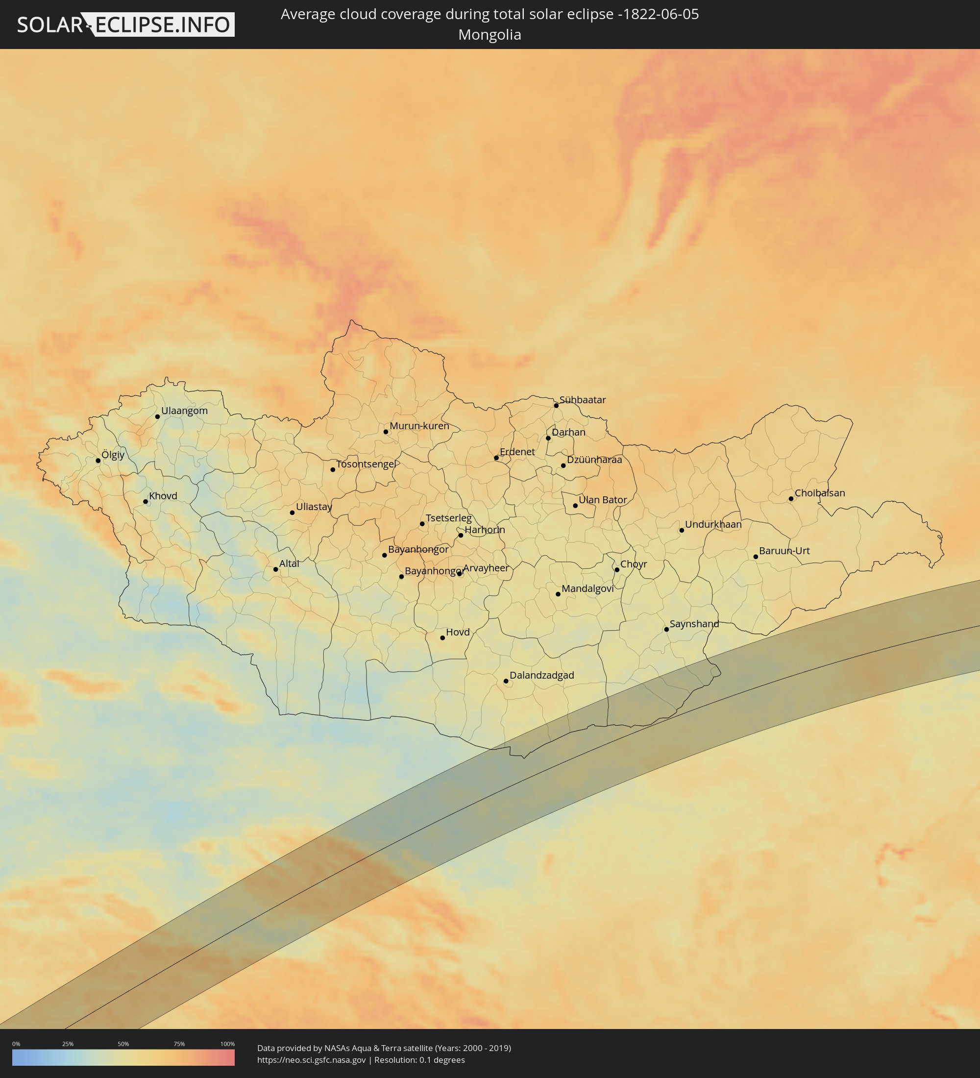 Mongolia
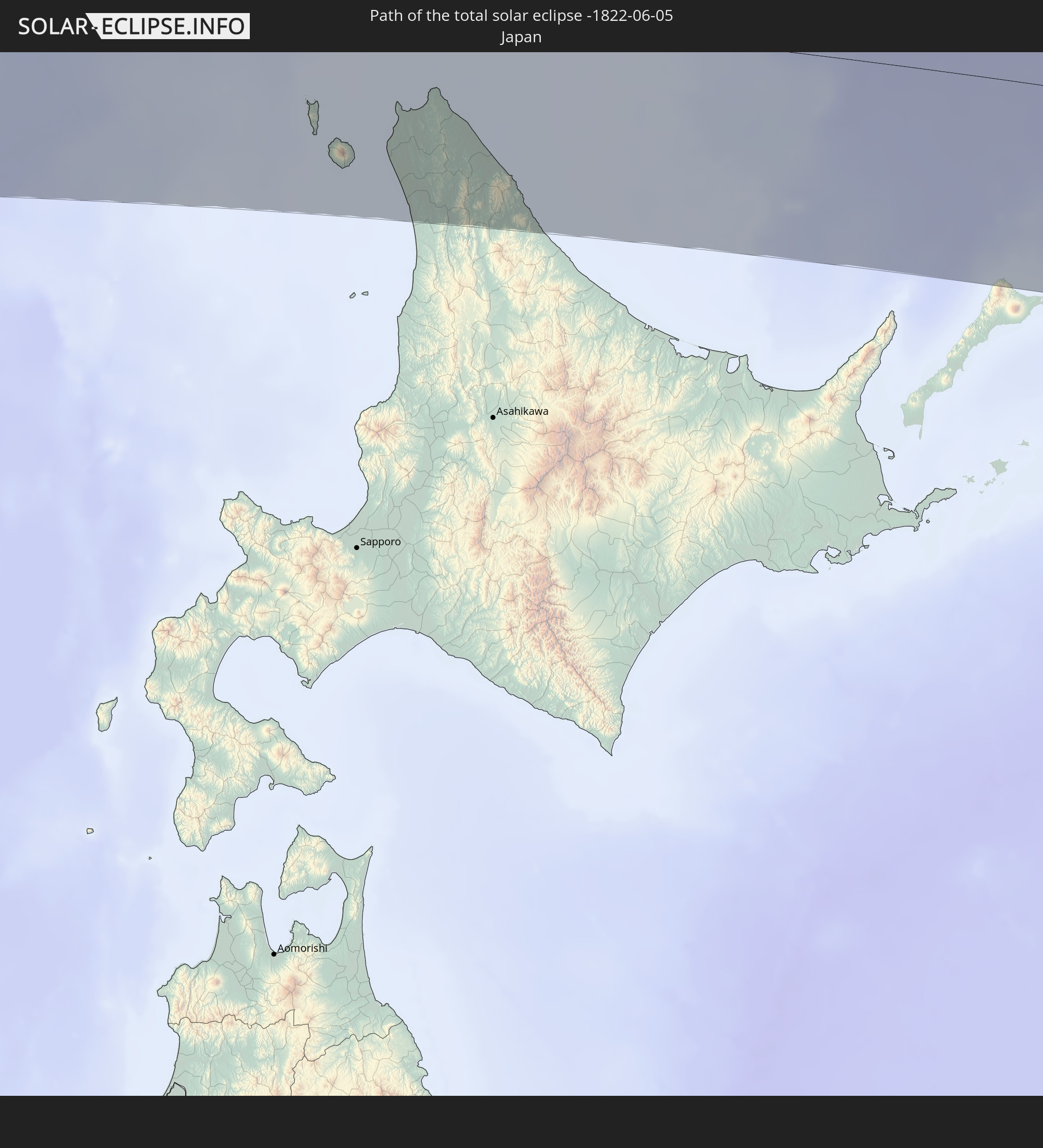
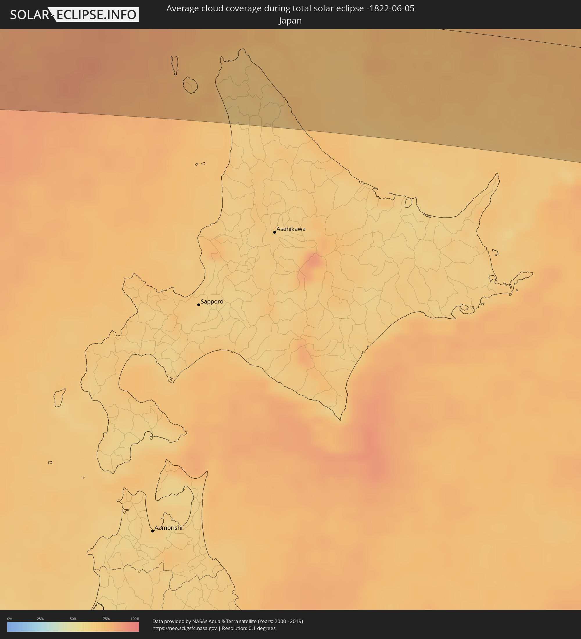 Japan
Japan
Cities inside the path of the eclipse
The following table shows all locations with a population of more than 5,000 inside the eclipse path. Cities which have more than 100,000 inhabitants are marked bold. A click at the locations opens a detailed map.
| City | Type | Eclipse duration | Local time of max. eclipse | Distance to central line | Ø Cloud coverage |
|
Al Ghayz̧ah, Al Mahrah
|
total | - | 05:13:51 UTC+03:06 | 38 km | 37% |
|
Şalālah, Z̧ufār
|
total | - | 05:48:29 UTC+03:41 | 31 km | 70% |
|
Chuhar Jamāli, Sindh
|
total | - | 06:43:48 UTC+04:28 | 94 km | 31% |
|
Mīrpur Batoro, Sindh
|
total | - | 06:44:18 UTC+04:28 | 115 km | 26% |
|
Jāti, Sindh
|
total | - | 06:43:49 UTC+04:28 | 78 km | 21% |
|
Kario, Sindh
|
total | - | 06:44:29 UTC+04:28 | 106 km | 31% |
|
Talhār, Sindh
|
total | - | 06:44:39 UTC+04:28 | 103 km | 30% |
|
Badīn, Sindh
|
total | - | 06:44:22 UTC+04:28 | 80 km | 29% |
|
Rājo Khanāni, Sindh
|
total | - | 06:44:47 UTC+04:28 | 111 km | 25% |
|
Tando Bāgo, Sindh
|
total | - | 06:44:34 UTC+04:28 | 87 km | 23% |
|
Kadhan, Sindh
|
total | - | 06:44:11 UTC+04:28 | 56 km | 29% |
|
Samaro, Sindh
|
total | - | 06:45:20 UTC+04:28 | 114 km | 19% |
|
Naukot, Sindh
|
total | - | 06:44:47 UTC+04:28 | 73 km | 21% |
|
Kunri, Sindh
|
total | - | 06:45:15 UTC+04:28 | 96 km | 19% |
|
Diplo, Sindh
|
total | - | 06:44:21 UTC+04:28 | 25 km | 25% |
|
Nabīsar, Sindh
|
total | - | 06:45:08 UTC+04:28 | 82 km | 17% |
|
Umarkot, Sindh
|
total | - | 06:45:32 UTC+04:28 | 106 km | 19% |
|
Mithi, Sindh
|
total | - | 06:44:45 UTC+04:28 | 42 km | 17% |
|
Islāmkot, Sindh
|
total | - | 06:44:50 UTC+04:28 | 19 km | 19% |
|
Jodhpur, Rajasthan
|
total | - | 07:40:57 UTC+05:21 | 35 km | 12% |
|
Pāli, Rajasthan
|
total | - | 07:40:26 UTC+05:21 | 29 km | 14% |
|
Ajmer, Rajasthan
|
total | - | 07:41:59 UTC+05:21 | 28 km | 15% |
|
Sīkar, Rajasthan
|
total | - | 07:43:51 UTC+05:21 | 59 km | 17% |
|
Jaipur, Rajasthan
|
total | - | 07:43:13 UTC+05:21 | 40 km | 19% |
|
Rohtak, Haryana
|
total | - | 07:46:29 UTC+05:21 | 111 km | 28% |
|
Alwar, Rajasthan
|
total | - | 07:44:36 UTC+05:21 | 19 km | 40% |
|
Sonīpat, Haryana
|
total | - | 07:46:53 UTC+05:21 | 99 km | 53% |
|
Gurgaon, Haryana
|
total | - | 07:46:07 UTC+05:21 | 47 km | 44% |
|
Nāngloi Jāt, NCT
|
total | - | 07:46:27 UTC+05:21 | 66 km | 35% |
|
Delhi, NCT
|
total | - | 07:46:31 UTC+05:21 | 55 km | 33% |
|
Farīdābād, Haryana
|
total | - | 07:46:13 UTC+05:21 | 28 km | 40% |
|
Ghāziābād, Uttar Pradesh
|
total | - | 07:46:40 UTC+05:21 | 46 km | 38% |
|
Bharatpur, Rajasthan
|
total | - | 07:44:38 UTC+05:21 | 95 km | 68% |
|
Greater Noida, Uttar Pradesh
|
total | - | 07:46:29 UTC+05:21 | 25 km | 52% |
|
Mathura, Uttar Pradesh
|
total | - | 07:45:09 UTC+05:21 | 77 km | 63% |
|
Muzaffarnagar, Uttar Pradesh
|
total | - | 07:48:00 UTC+05:21 | 110 km | 30% |
|
Meerut, Uttar Pradesh
|
total | - | 07:47:17 UTC+05:21 | 63 km | 32% |
|
Hāpur, Uttar Pradesh
|
total | - | 07:46:58 UTC+05:21 | 36 km | 33% |
|
Bulandshahr, Uttar Pradesh
|
total | - | 07:46:33 UTC+05:21 | 1 km | 32% |
|
Alīgarh, Uttar Pradesh
|
total | - | 07:45:56 UTC+05:21 | 60 km | 54% |
|
Sambhal, Uttar Pradesh
|
total | - | 07:47:16 UTC+05:21 | 17 km | 40% |
|
Morādābād, Uttar Pradesh
|
total | - | 07:47:47 UTC+05:21 | 3 km | 39% |
|
Rāmpur, Uttar Pradesh
|
total | - | 07:47:54 UTC+05:21 | 19 km | 40% |
|
Bareilly, Uttar Pradesh
|
total | - | 07:47:30 UTC+05:21 | 83 km | 41% |
|
Mahendranagar, Far Western
|
total | - | 08:09:05 UTC+05:41 | 73 km | 47% |
|
Dārchulā, Western Region
|
total | - | 07:50:30 UTC+05:21 | 5 km | 40% |
|
Dadeldhurā, Far Western
|
total | - | 08:09:50 UTC+05:41 | 49 km | 51% |
|
Dhangarhi, Far Western
|
total | - | 08:08:59 UTC+05:41 | 106 km | 48% |
|
Dipayal, Far Western
|
total | - | 08:10:03 UTC+05:41 | 71 km | 43% |
|
Zhangye, Gansu
|
total | - | 11:06:25 UTC+08:00 | 36 km | 45% |
|
Xilin Hot, Inner Mongolia
|
total | - | 11:39:07 UTC+08:00 | 10 km | 50% |
|
Ulanhot, Inner Mongolia
|
total | - | 11:51:18 UTC+08:00 | 104 km | 53% |
|
Guangming, Jilin
|
total | - | 11:52:18 UTC+08:00 | 12 km | 55% |
|
Baicheng, Jilin
|
total | - | 11:52:28 UTC+08:00 | 41 km | 57% |
|
Dalai, Jilin
|
total | - | 11:55:07 UTC+08:00 | 9 km | 56% |
|
Fuyu, Jilin
|
total | - | 11:55:59 UTC+08:00 | 32 km | 58% |
|
Honggang, Heilongjiang
|
total | - | 11:56:22 UTC+08:00 | 101 km | 63% |
|
Daqing, Heilongjiang
|
total | - | 11:56:37 UTC+08:00 | 120 km | 63% |
|
Anda, Heilongjiang
|
total | - | 11:57:08 UTC+08:00 | 96 km | 60% |
|
Dehui, Jilin
|
total | - | 11:57:30 UTC+08:00 | 114 km | 63% |
|
Zhaodong, Heilongjiang
|
total | - | 11:58:16 UTC+08:00 | 52 km | 61% |
|
Shuangcheng, Heilongjiang
|
total | - | 11:58:43 UTC+08:00 | 31 km | 60% |
|
Yushu, Jilin
|
total | - | 11:59:06 UTC+08:00 | 94 km | 63% |
|
Hulan, Heilongjiang
|
total | - | 11:59:22 UTC+08:00 | 36 km | 61% |
|
Harbin, Heilongjiang
|
total | - | 11:59:26 UTC+08:00 | 10 km | 59% |
|
Acheng, Heilongjiang
|
total | - | 12:00:00 UTC+08:00 | 16 km | 63% |
|
Suihua, Heilongjiang
|
total | - | 12:00:08 UTC+08:00 | 104 km | 64% |
|
Wuchang, Heilongjiang
|
total | - | 12:00:15 UTC+08:00 | 88 km | 59% |
|
Jiamusi, Heilongjiang
|
total | - | 12:05:54 UTC+08:00 | 96 km | 66% |
|
Boli, Heilongjiang
|
total | - | 12:06:27 UTC+08:00 | 21 km | 70% |
|
Taihe, Heilongjiang
|
total | - | 12:06:56 UTC+08:00 | 22 km | 70% |
|
Jixi, Heilongjiang
|
total | - | 12:07:11 UTC+08:00 | 74 km | 67% |
|
Shuangyashan, Heilongjiang
|
total | - | 12:07:21 UTC+08:00 | 74 km | 70% |
|
Baoshan, Heilongjiang
|
total | - | 12:07:50 UTC+08:00 | 64 km | 71% |
|
Lesozavodsk, Primorskiy
|
total | - | 12:59:02 UTC+08:47 | 64 km | 68% |
|
Kirovskiy, Primorskiy
|
total | - | 12:59:16 UTC+08:47 | 107 km | 64% |
|
Gornyye Klyuchi, Primorskiy
|
total | - | 12:59:14 UTC+08:47 | 90 km | 67% |
|
Dal’nerechensk, Primorskiy
|
total | - | 12:59:27 UTC+08:47 | 14 km | 64% |
|
Luchegorsk, Primorskiy
|
total | - | 13:00:04 UTC+08:47 | 46 km | 69% |
|
Bikin, Khabarovsk Krai
|
total | - | 13:00:03 UTC+08:47 | 83 km | 64% |
|
Wakkanai, Hokkaido
|
total | - | 13:25:11 UTC+09:00 | 55 km | 67% |
|
Makubetsu, Hokkaido
|
total | - | 13:25:26 UTC+09:00 | 59 km | 67% |
|
Gornozavodsk, Sakhalin
|
total | - | 14:39:32 UTC+10:14 | 73 km | 78% |
|
Nevel’sk, Sakhalin
|
total | - | 14:39:29 UTC+10:14 | 87 km | 72% |
|
Aniva, Sakhalin
|
total | - | 14:40:27 UTC+10:14 | 95 km | 73% |
|
Korsakov, Sakhalin
|
total | - | 14:40:52 UTC+10:14 | 88 km | 74% |