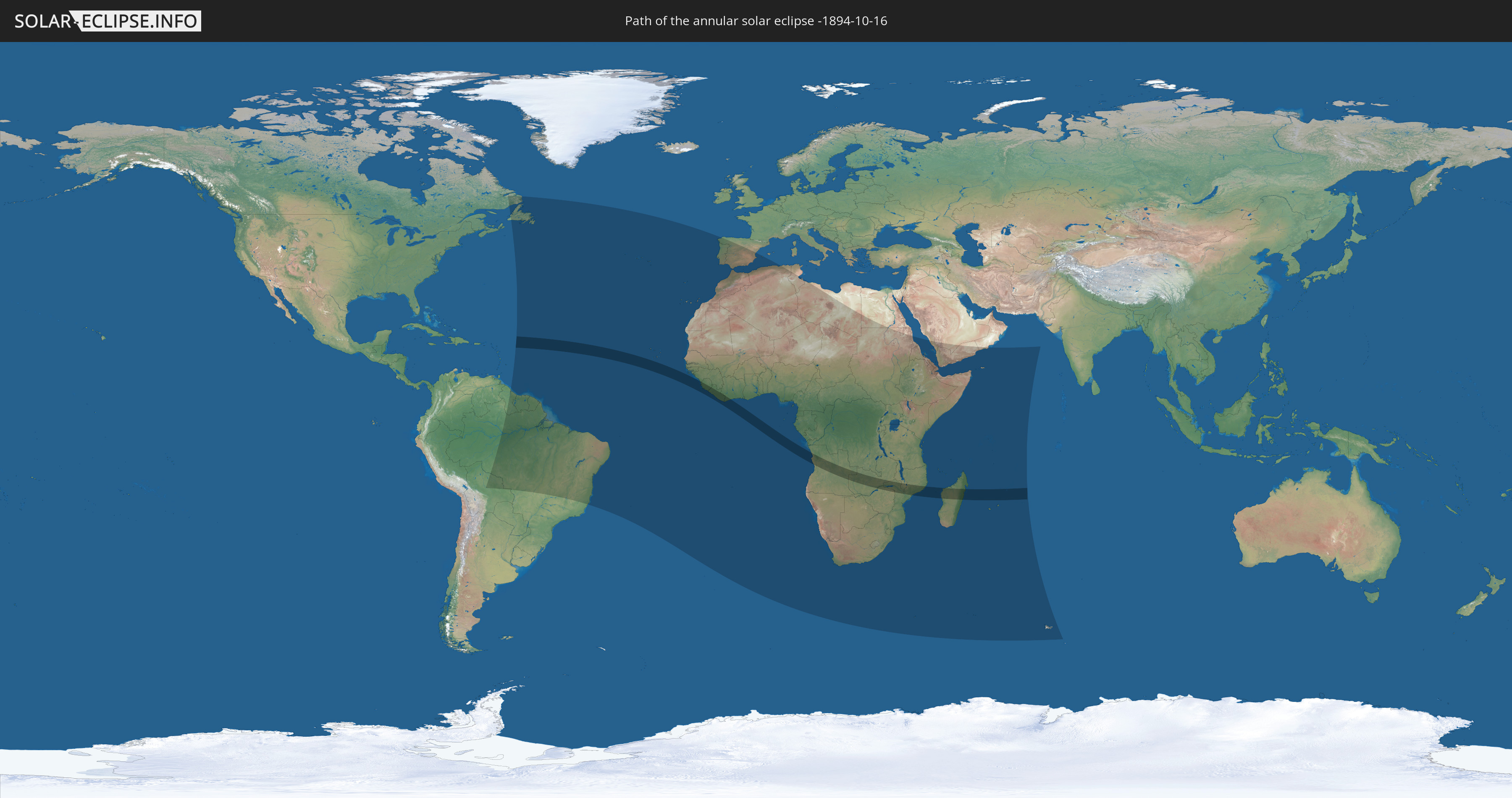
Annular solar eclipse of 10/16/-1894
| Day of week: | Thursday |
| Maximum duration of eclipse: | 07m51s |
| Maximum width of eclipse path: | 232 km |
| Saros cycle: | 13 |
| Coverage: | 93.8% |
| Magnitude: | 0.9375 |
| Gamma: | 0.0099 |
Wo kann man die Sonnenfinsternis vom 10/16/-1894 sehen?
Die Sonnenfinsternis am 10/16/-1894 kann man in 70 Ländern als partielle Sonnenfinsternis beobachten.
Der Finsternispfad verläuft durch 12 Länder. Nur in diesen Ländern ist sie als annular Sonnenfinsternis zu sehen.
In den folgenden Ländern ist die Sonnenfinsternis annular zu sehen
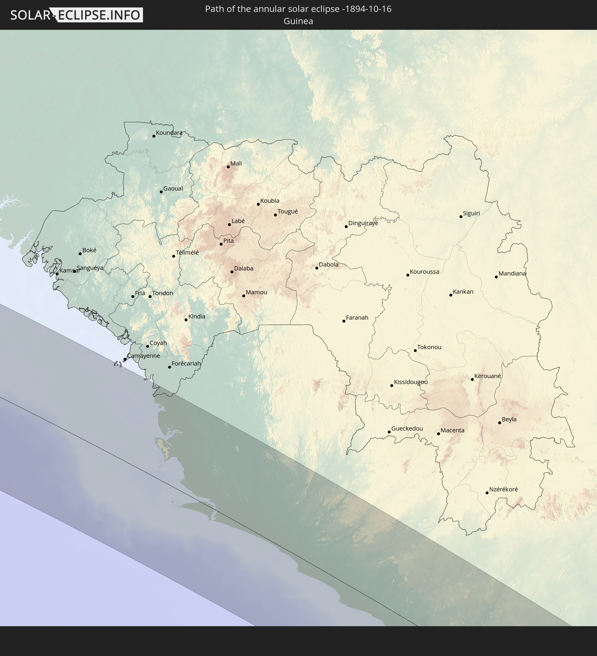 Guinea
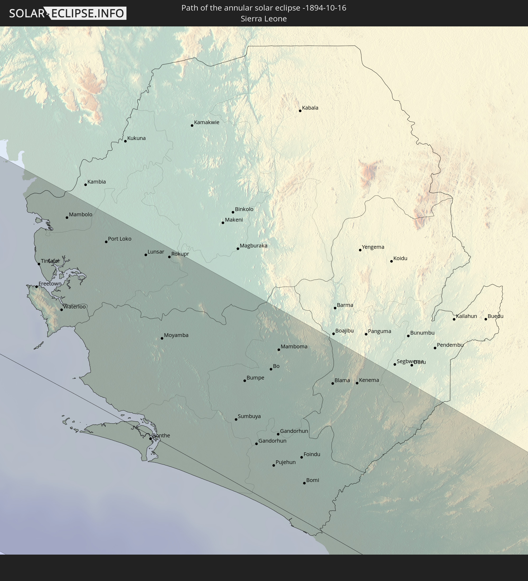 Sierra Leone
 Liberia
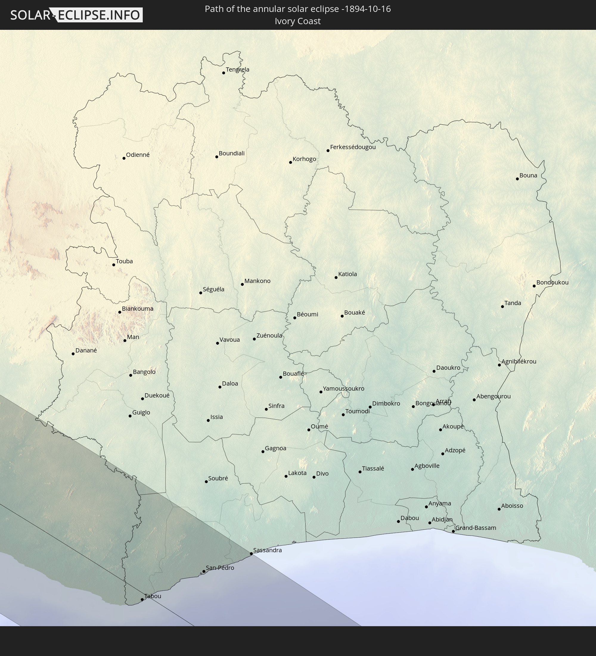 Ivory Coast
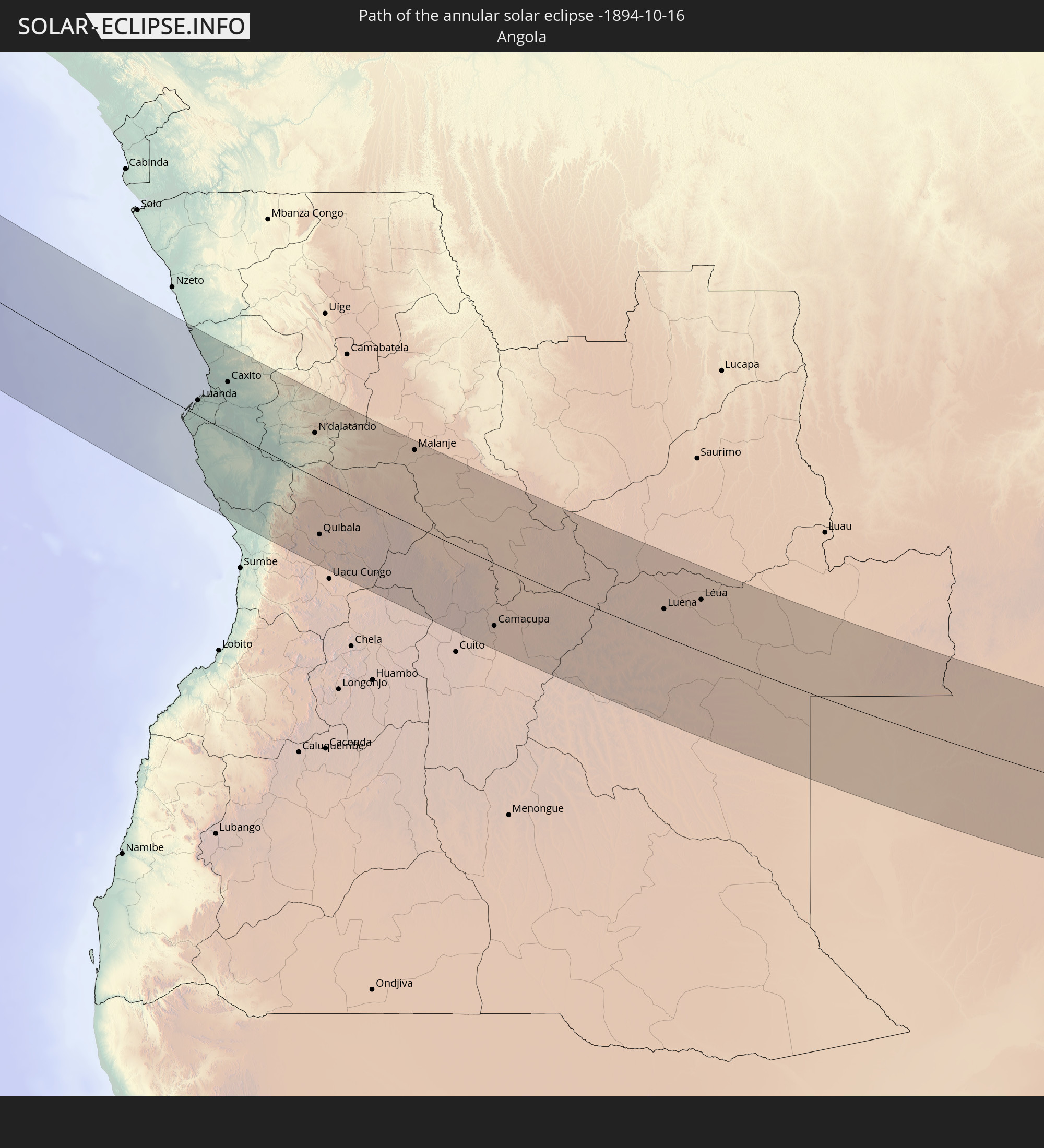 Angola
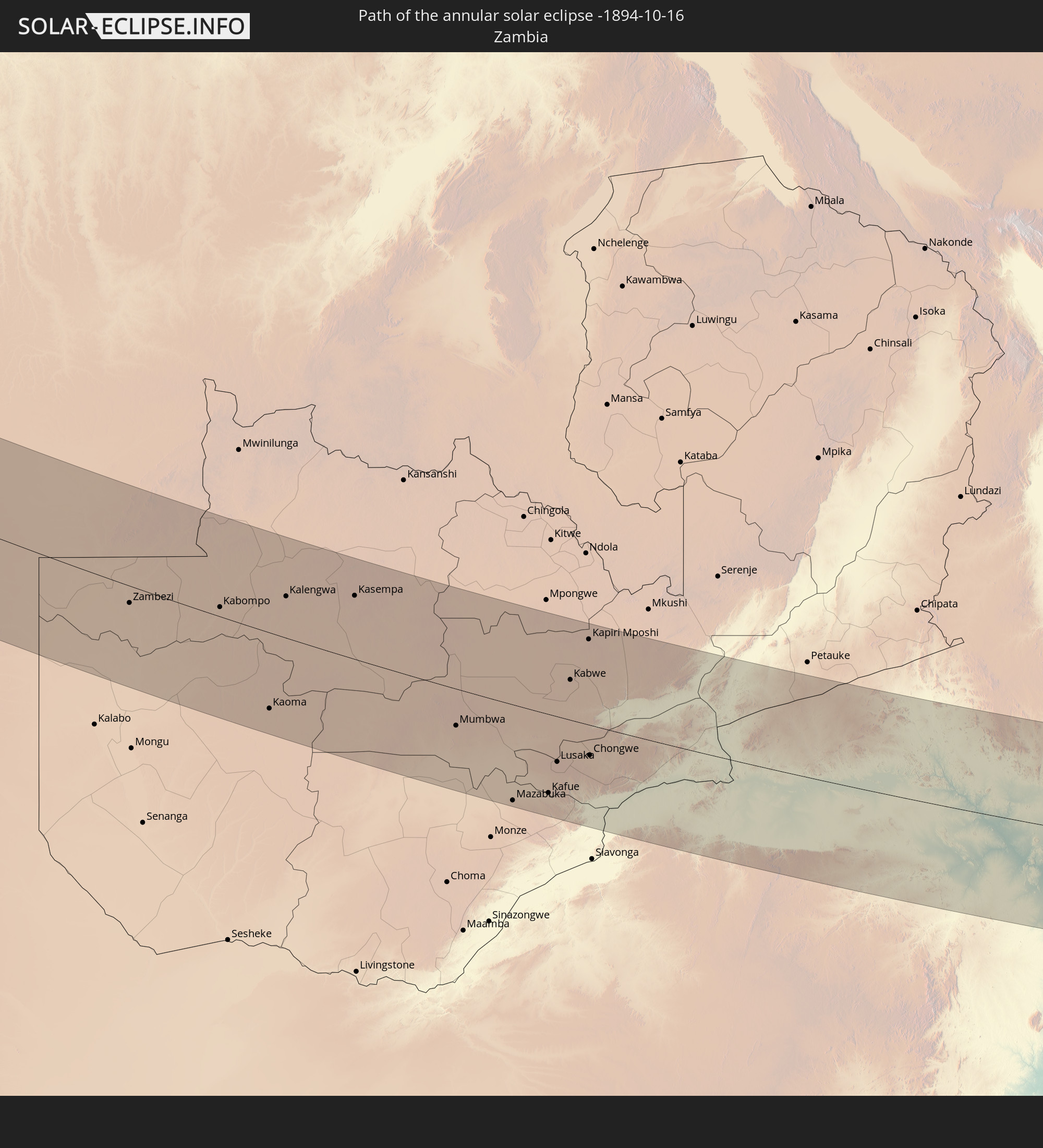 Zambia
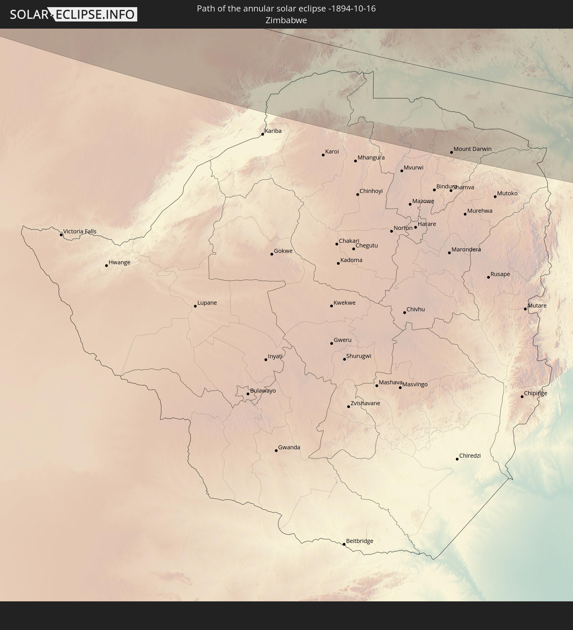 Zimbabwe
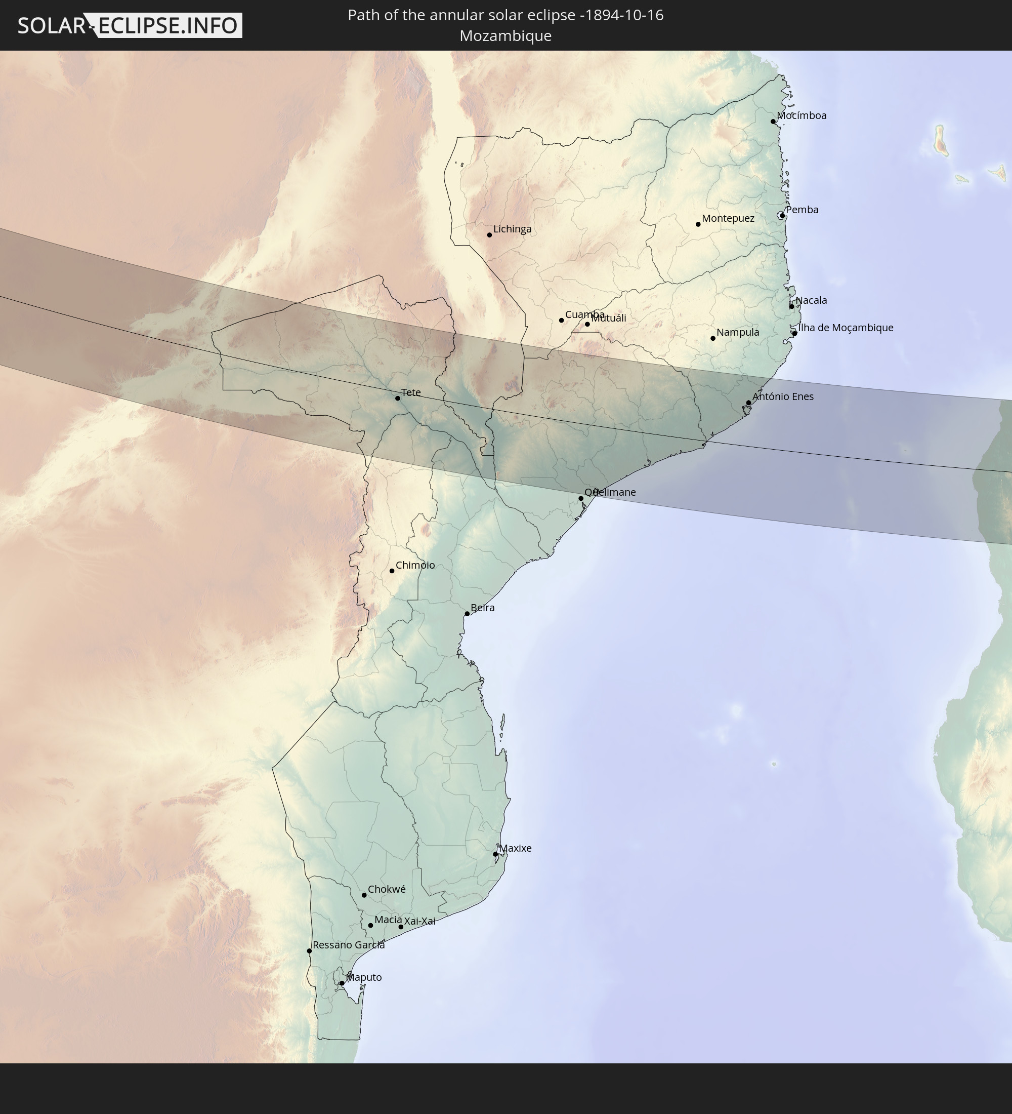 Mozambique
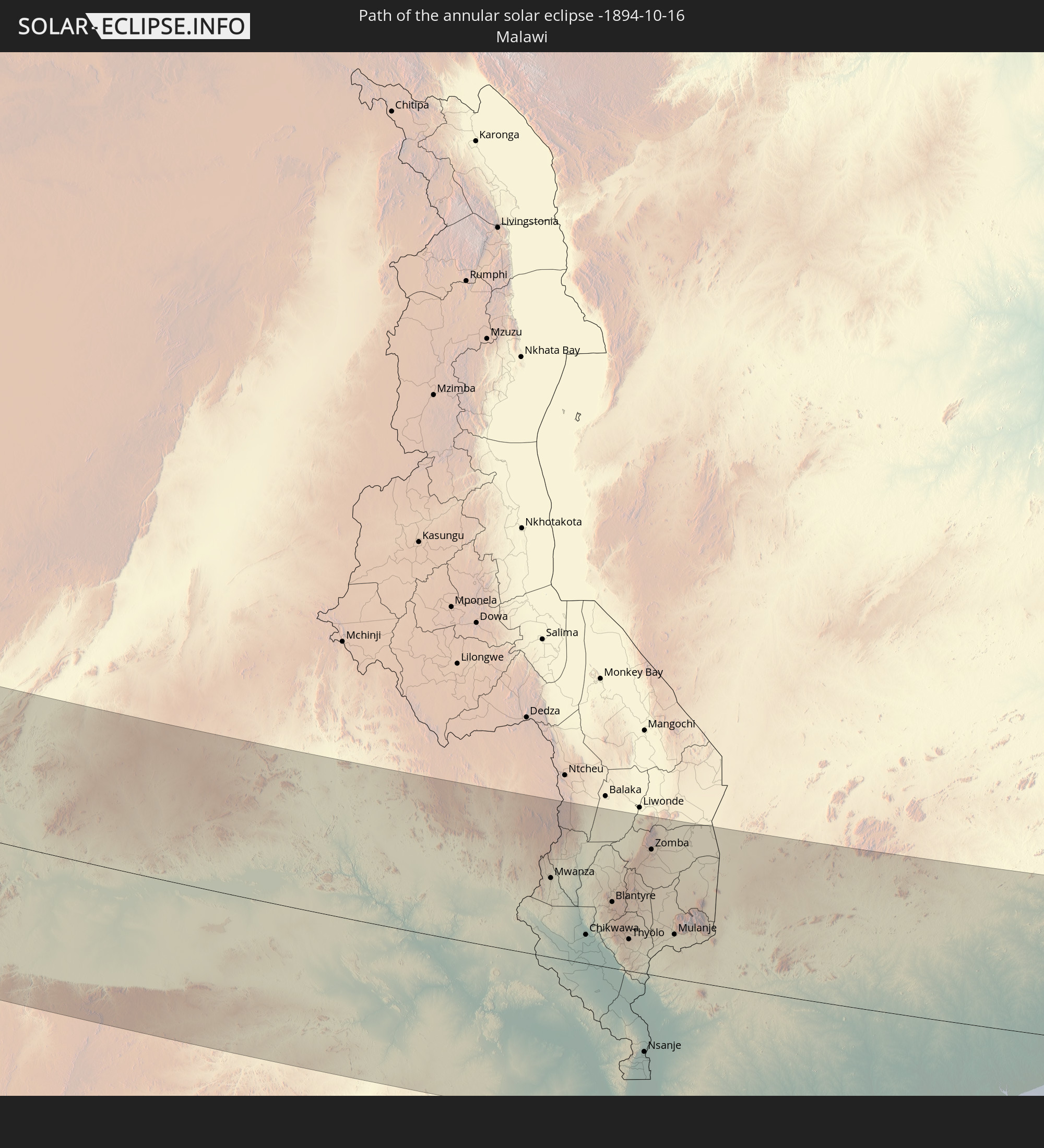 Malawi
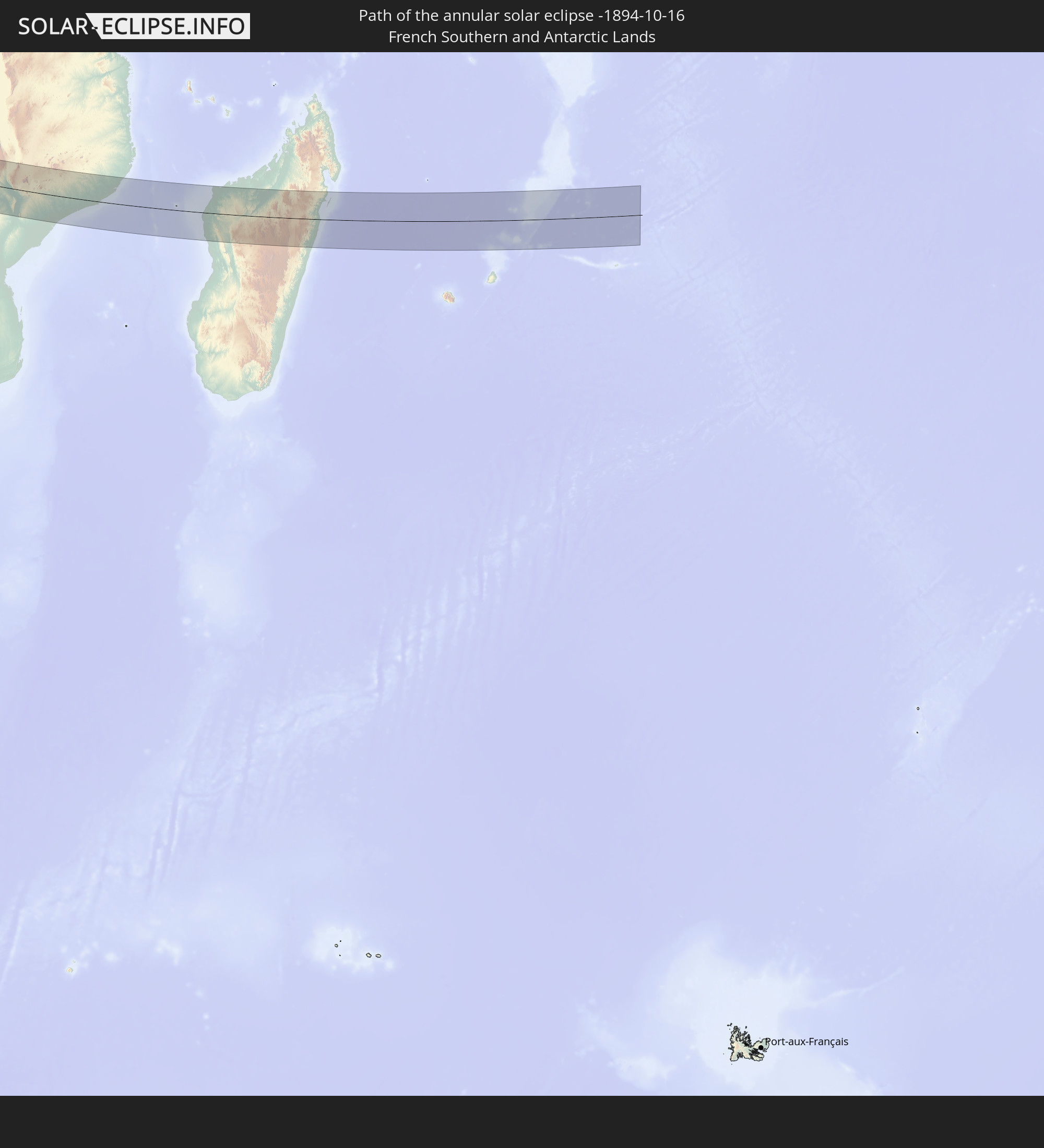 French Southern and Antarctic Lands
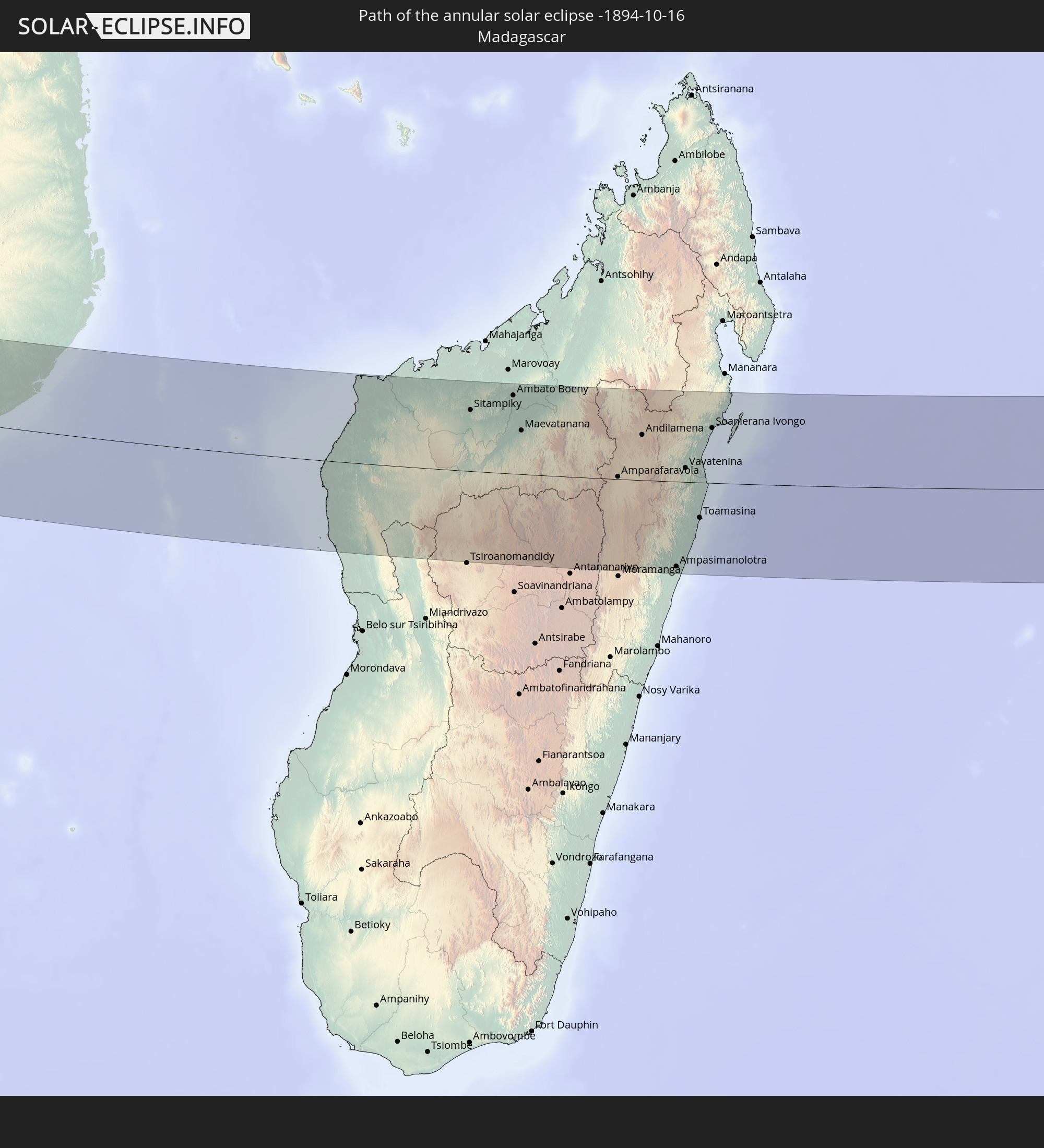 Madagascar
 Mauritius
In den folgenden Ländern ist die Sonnenfinsternis partiell zu sehen
 Canada
 Brazil
 Bolivia
 Guyana
 Suriname
 Saint Pierre and Miquelon
 French Guiana
 Portugal
 Cabo Verde
 Spain
Spain
 Senegal
 Mauritania
 The Gambia
 Guinea-Bissau
 Guinea
 Saint Helena, Ascension and Tristan da Cunha
 Sierra Leone
 Morocco
 Mali
Mali
 Liberia
 Algeria
 Ivory Coast
 Burkina Faso
 Gibraltar
 Ghana
Ghana
 Togo
Togo
 Niger
Niger
 Benin
Benin
 Nigeria
 Equatorial Guinea
 São Tomé and Príncipe
 Tunisia
 Cameroon
 Gabon
Gabon
 Libya
Libya
 Republic of the Congo
 Angola
 Namibia
 Democratic Republic of the Congo
 Chad
Chad
 Central African Republic
 South Africa
 Botswana
 Sudan
Sudan
 Zambia
 Egypt
Egypt
 Zimbabwe
 Lesotho
 Rwanda
 Burundi
 Tanzania
 Uganda
 Mozambique
 Swaziland
 Malawi
 Ethiopia
 Kenya
Kenya
 Saudi Arabia
 Eritrea
 French Southern and Antarctic Lands
 Somalia
 Djibouti
 Yemen
Yemen
 Madagascar
 Comoros
 Mayotte
 Seychelles
 Oman
Oman
 Réunion
 Mauritius
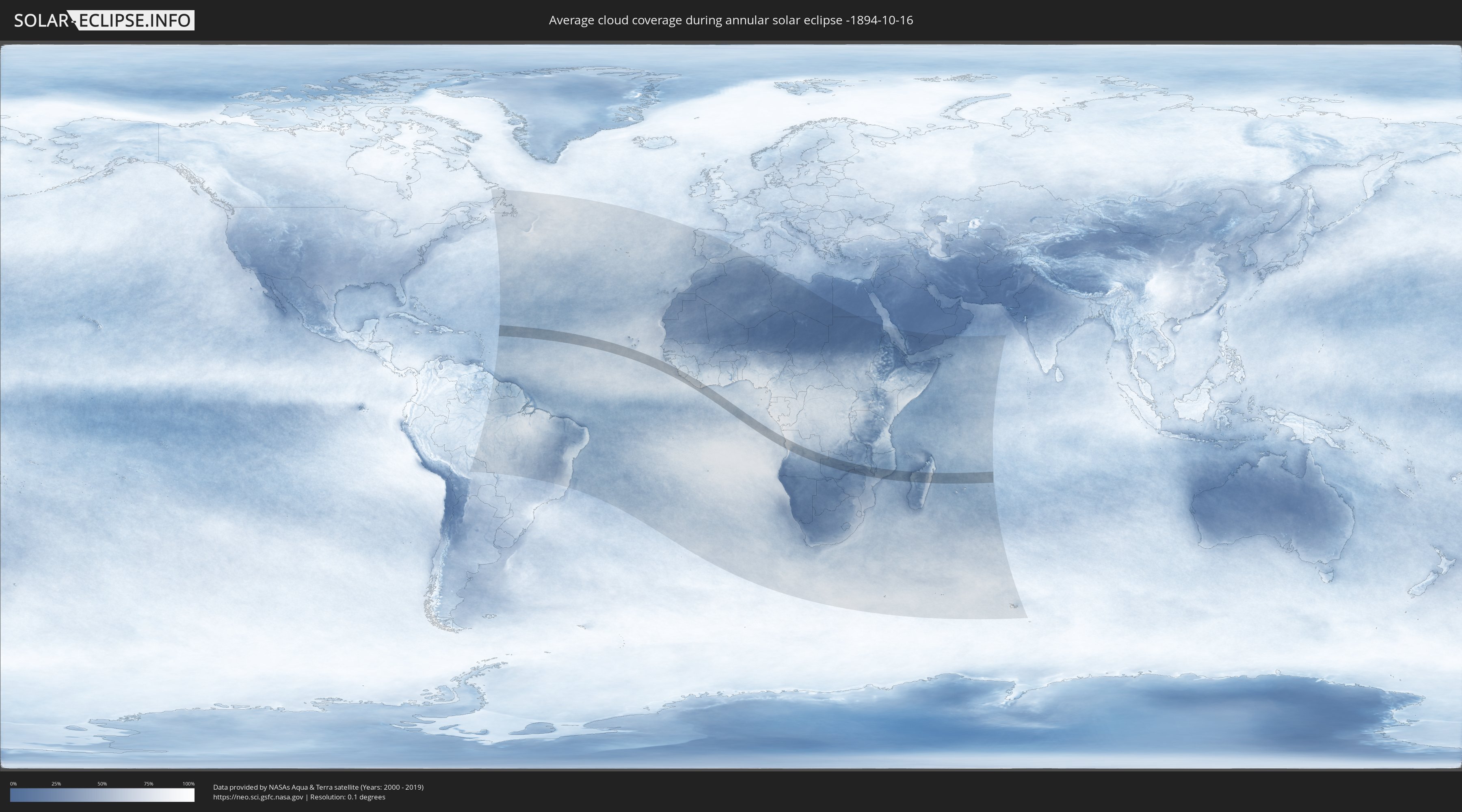
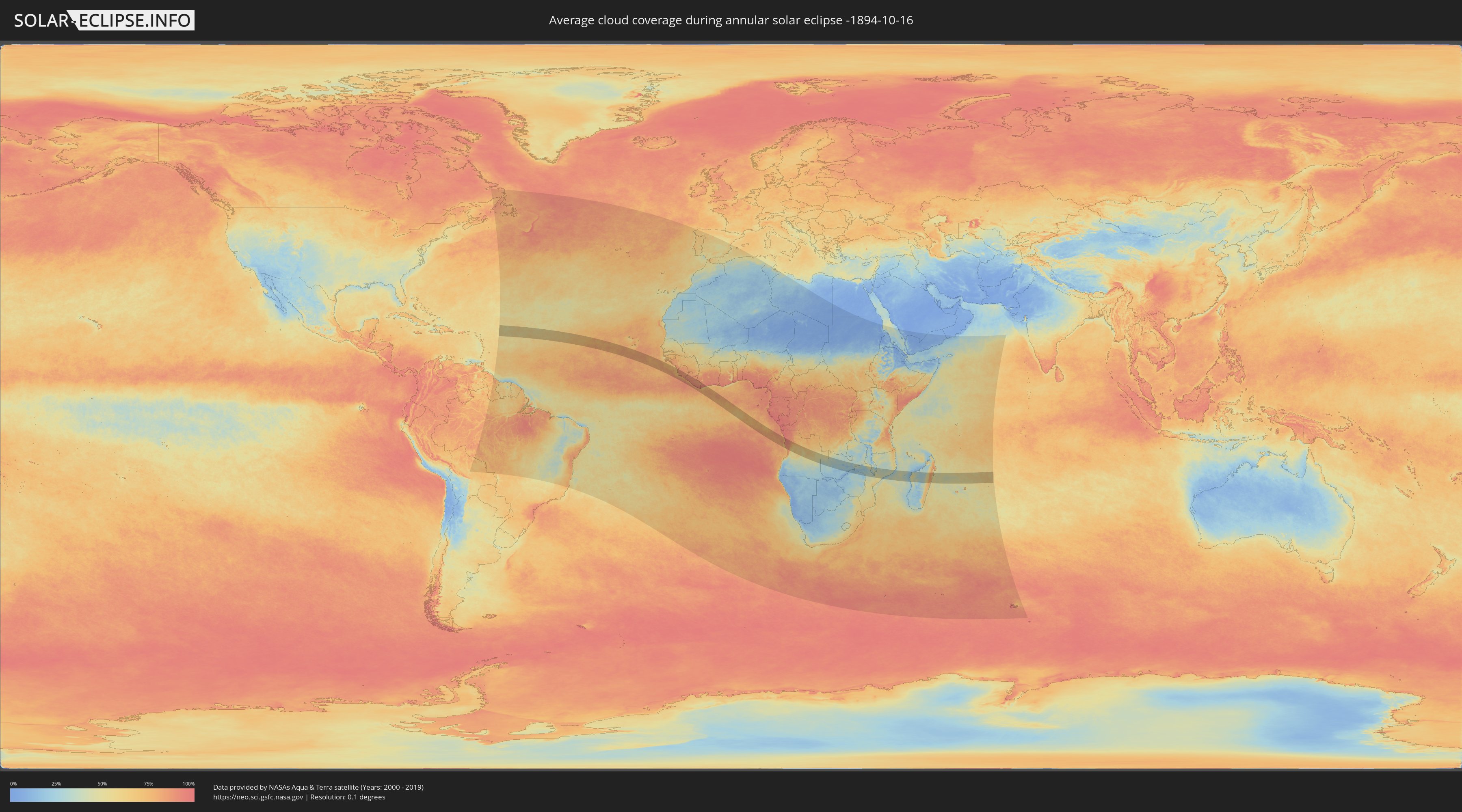
How will be the weather during the annular solar eclipse on 10/16/-1894?
Where is the best place to see the annular solar eclipse of 10/16/-1894?
The following maps show the average cloud coverage for the day of the annular solar eclipse.
With the help of these maps, it is possible to find the place along the eclipse path, which has the best
chance of a cloudless sky.
Nevertheless, you should consider local circumstances and inform about the weather of your chosen
observation site.
The data is provided by NASAs satellites
AQUA and TERRA.
The cloud maps are averaged over a period of 19 years (2000 - 2019).
Detailed country maps
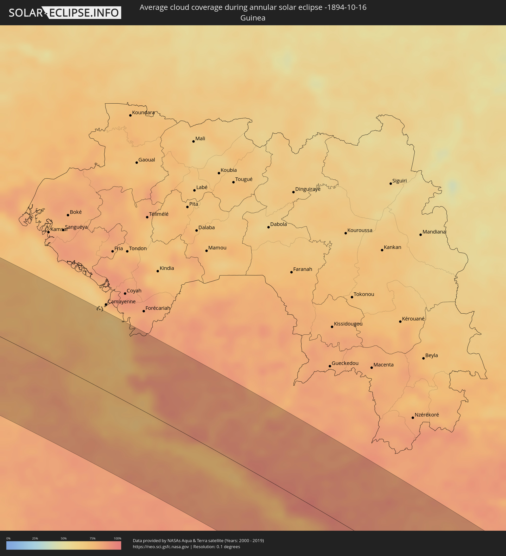 Guinea
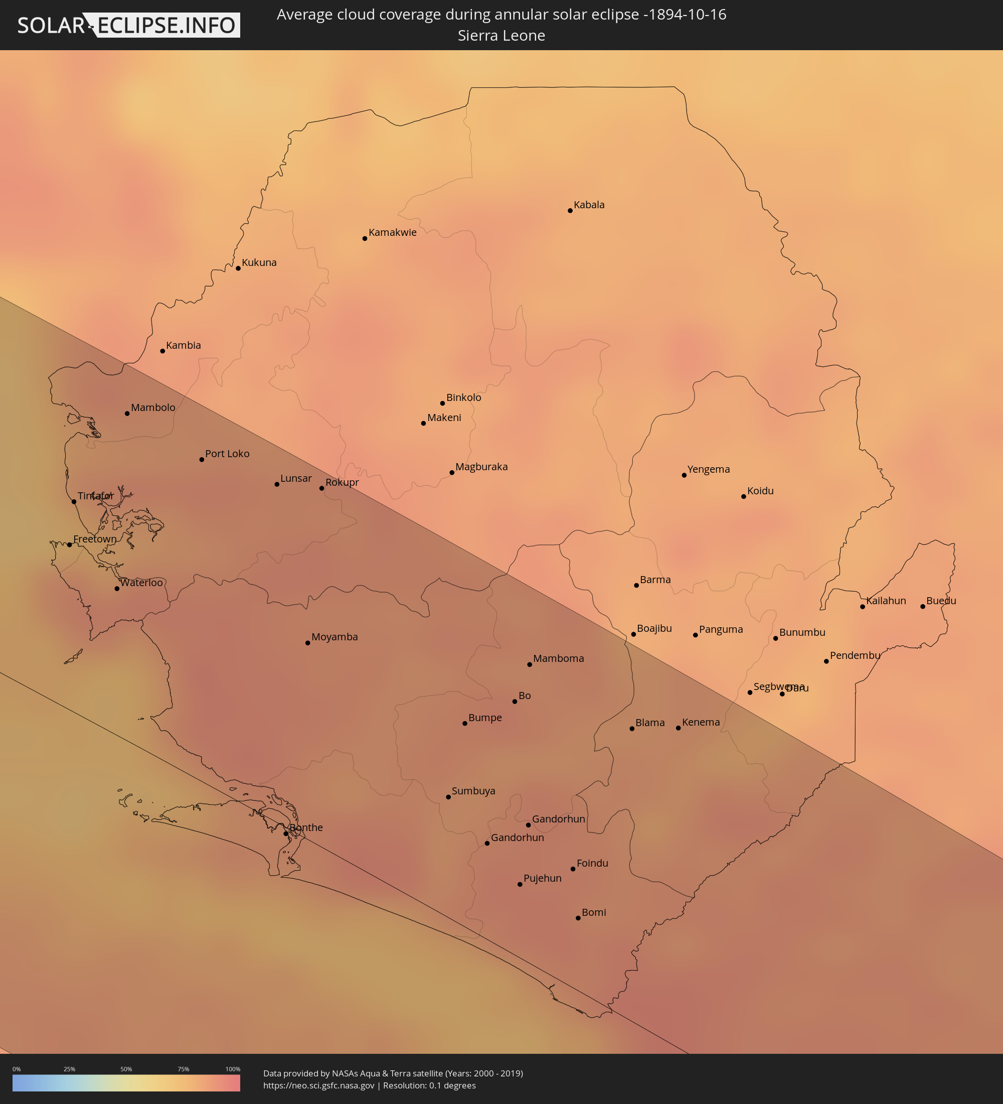 Sierra Leone
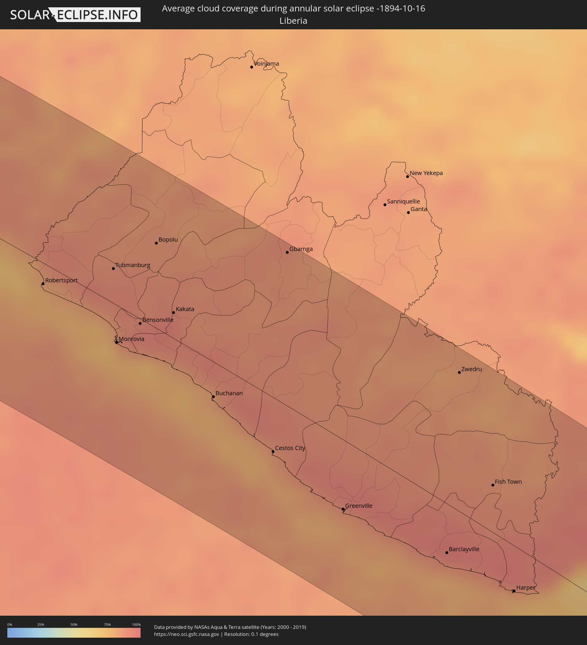 Liberia
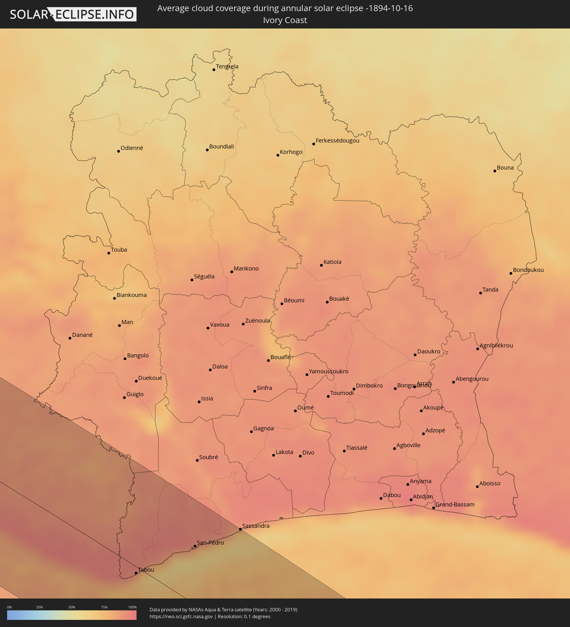 Ivory Coast
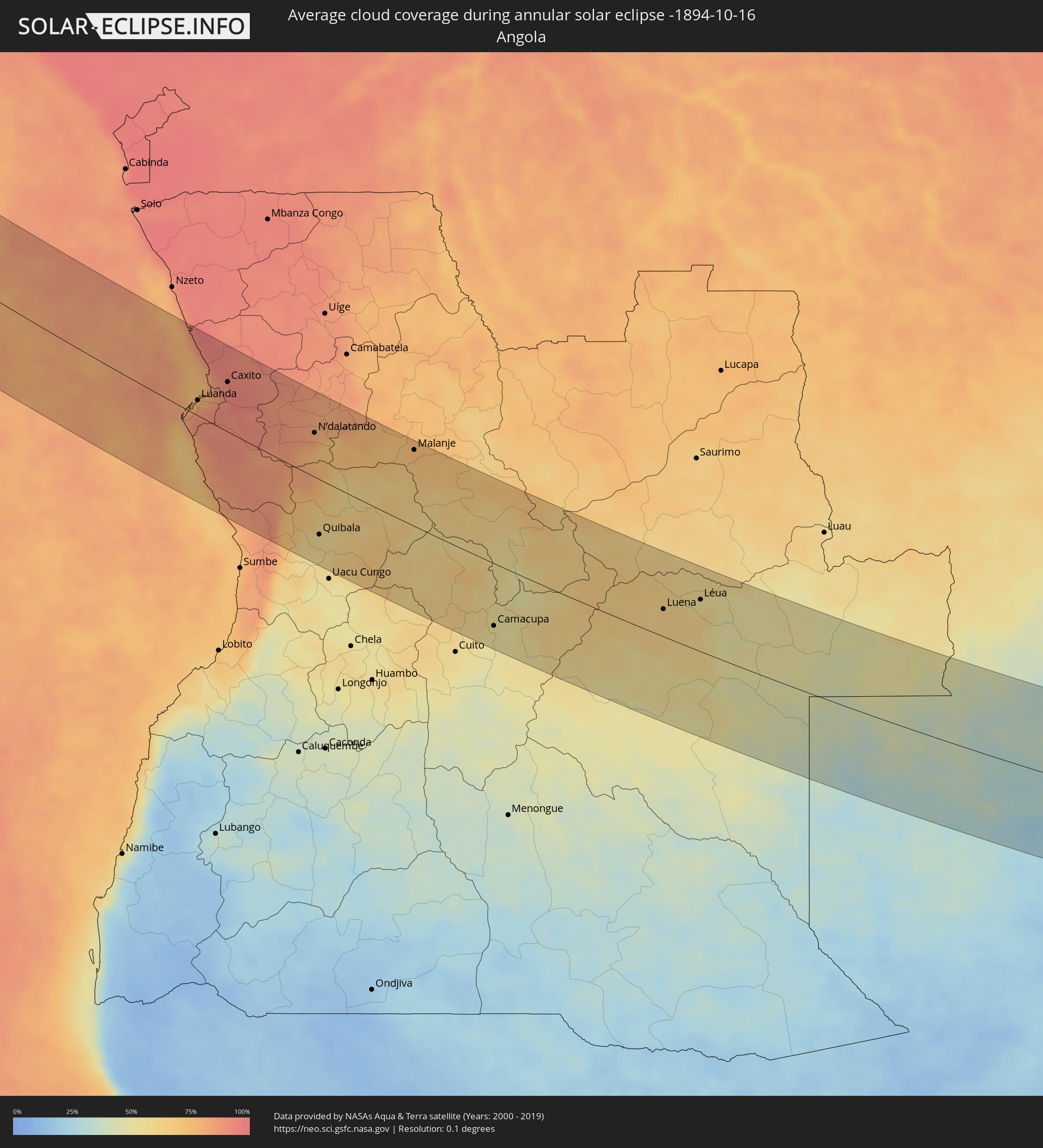 Angola
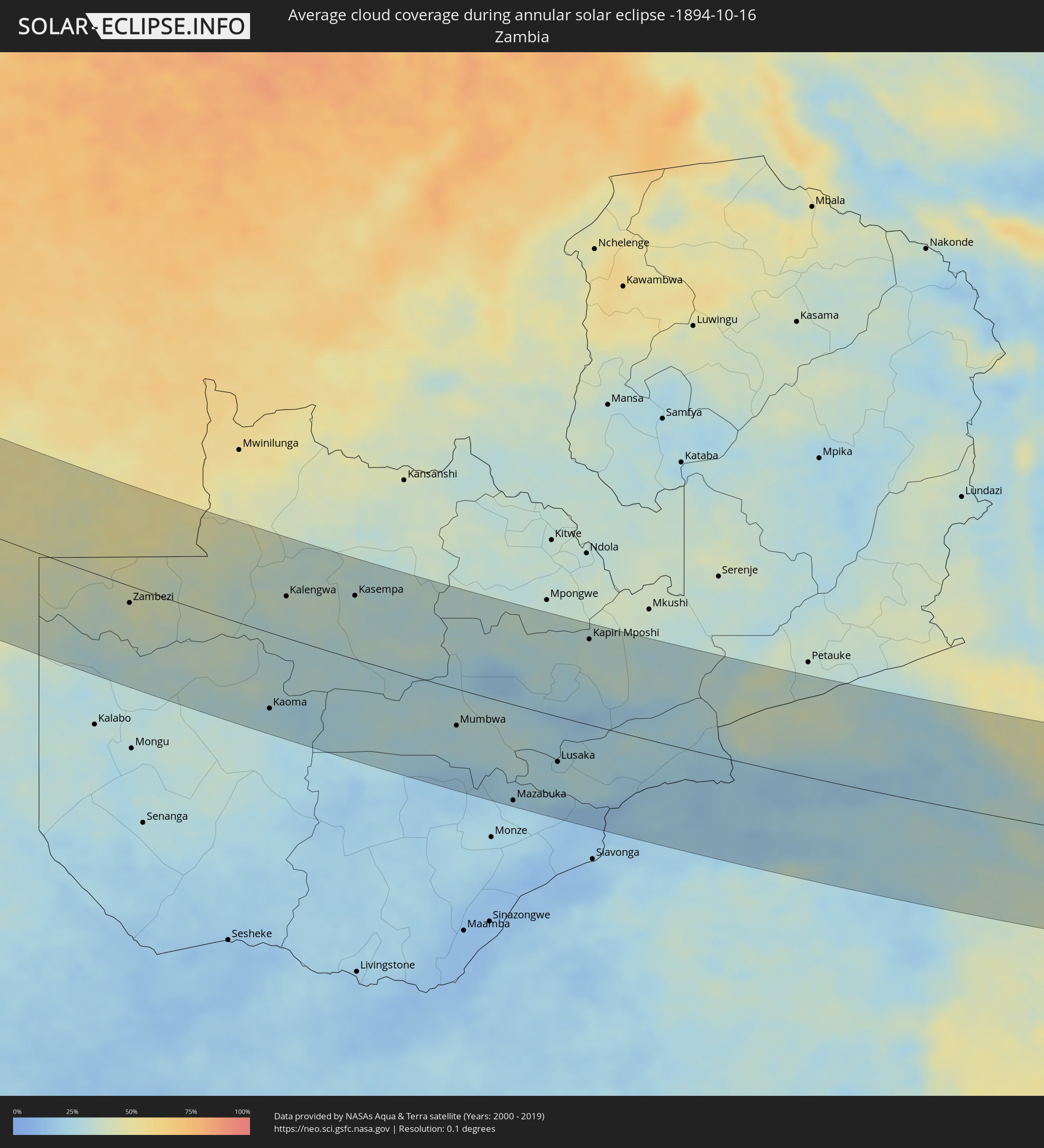 Zambia
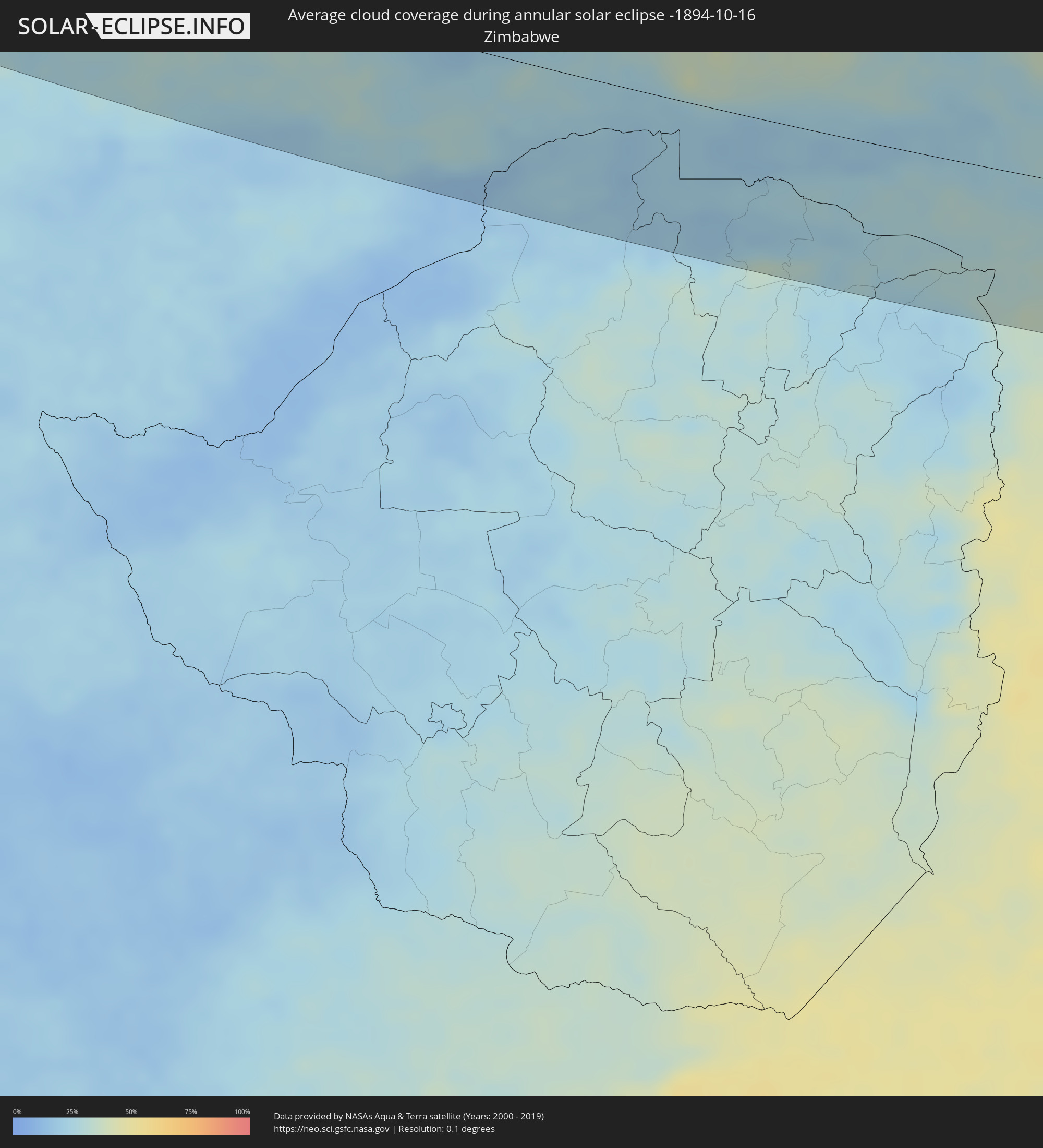 Zimbabwe
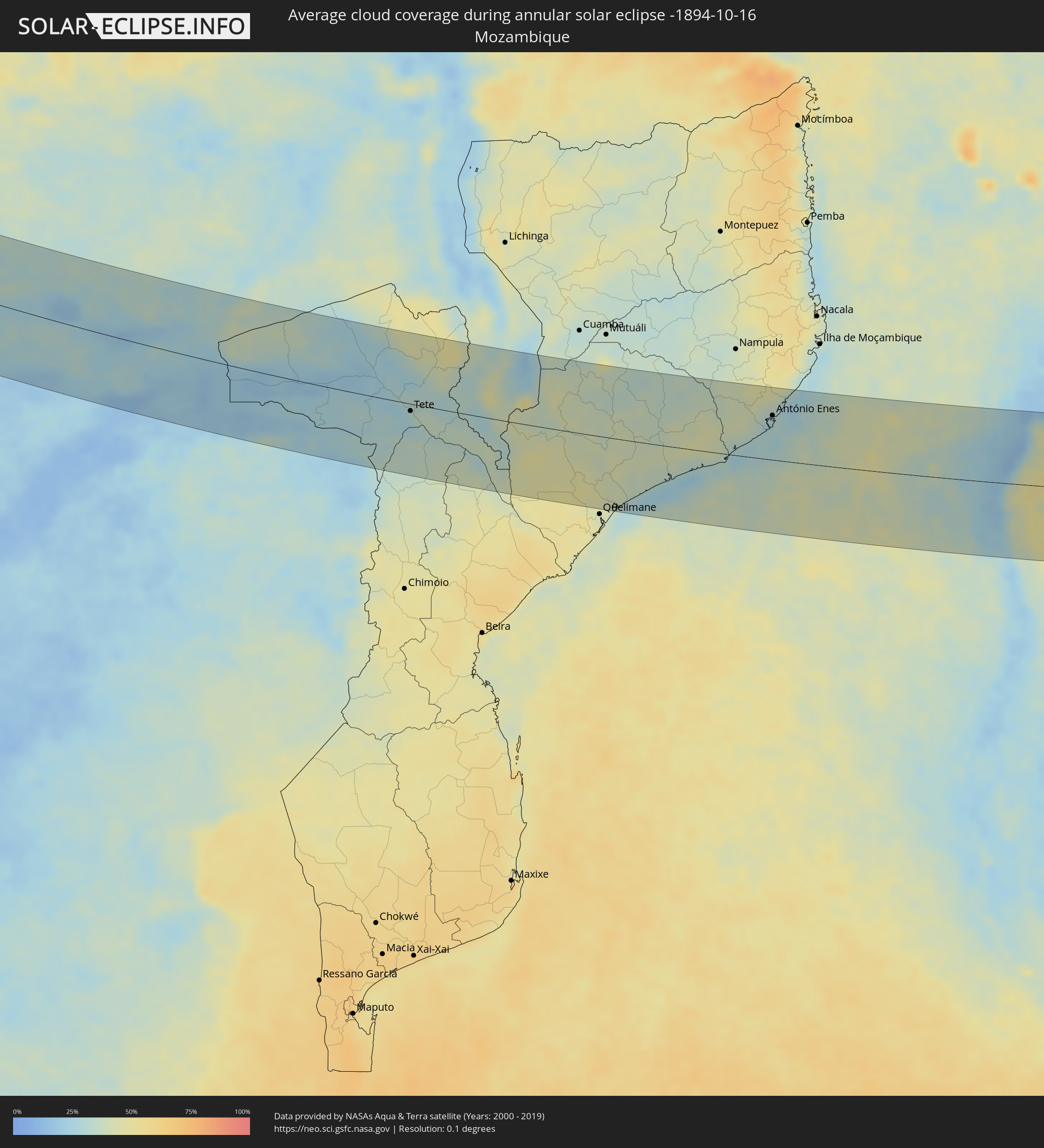 Mozambique
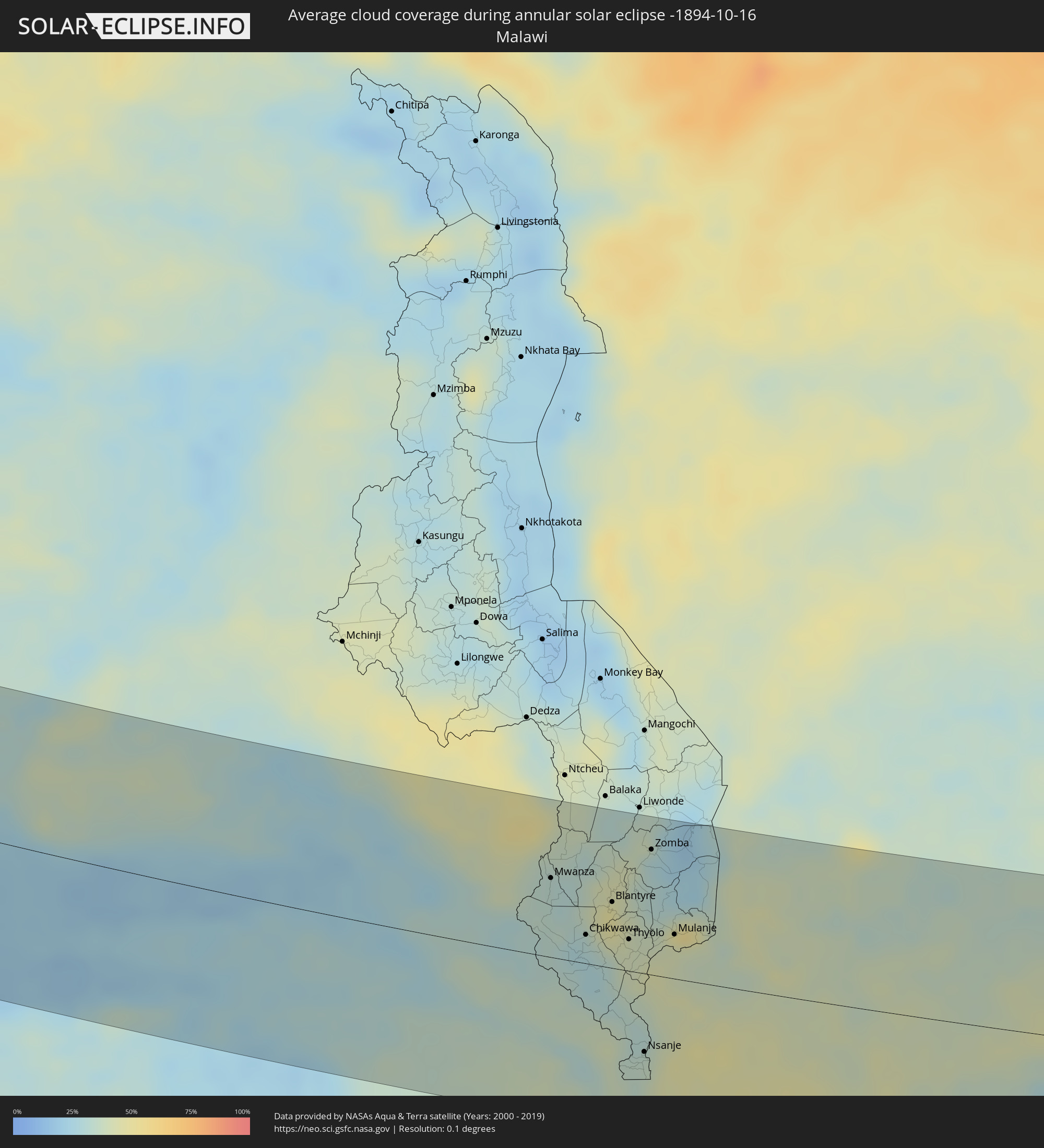 Malawi
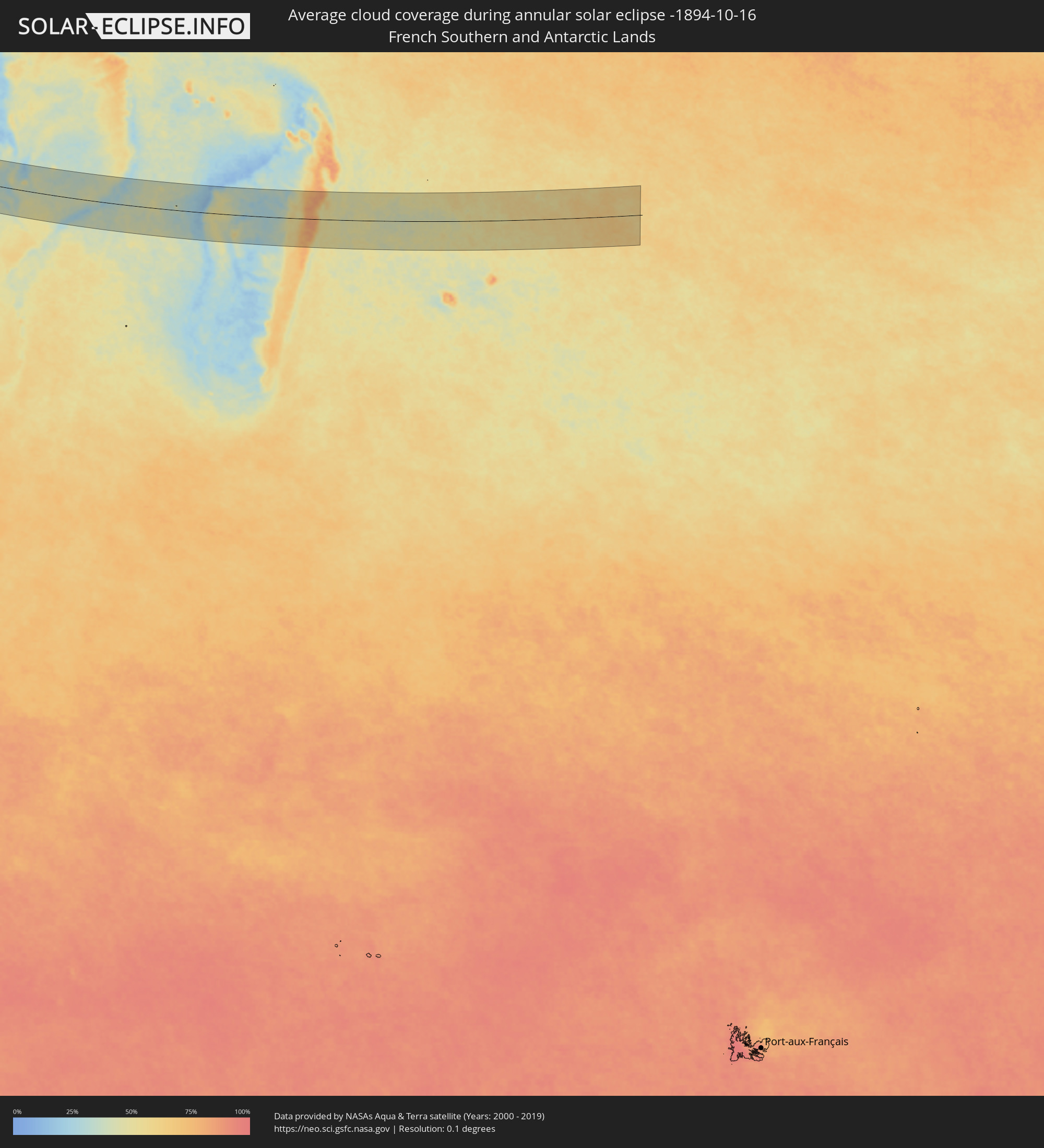 French Southern and Antarctic Lands
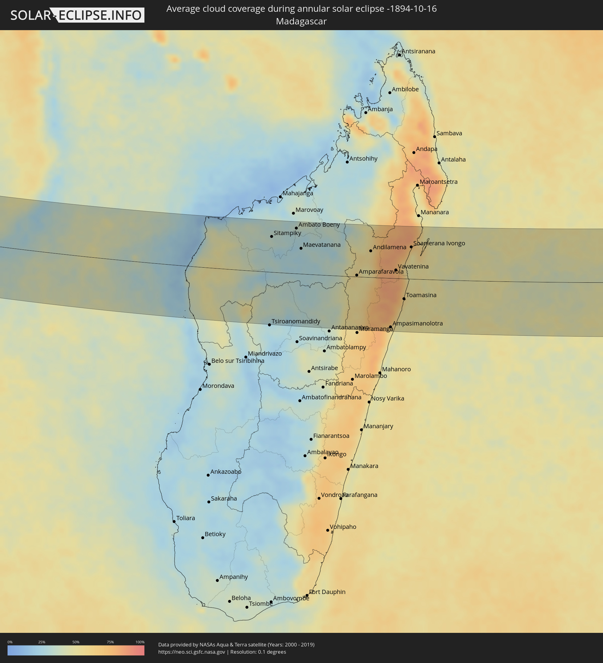 Madagascar
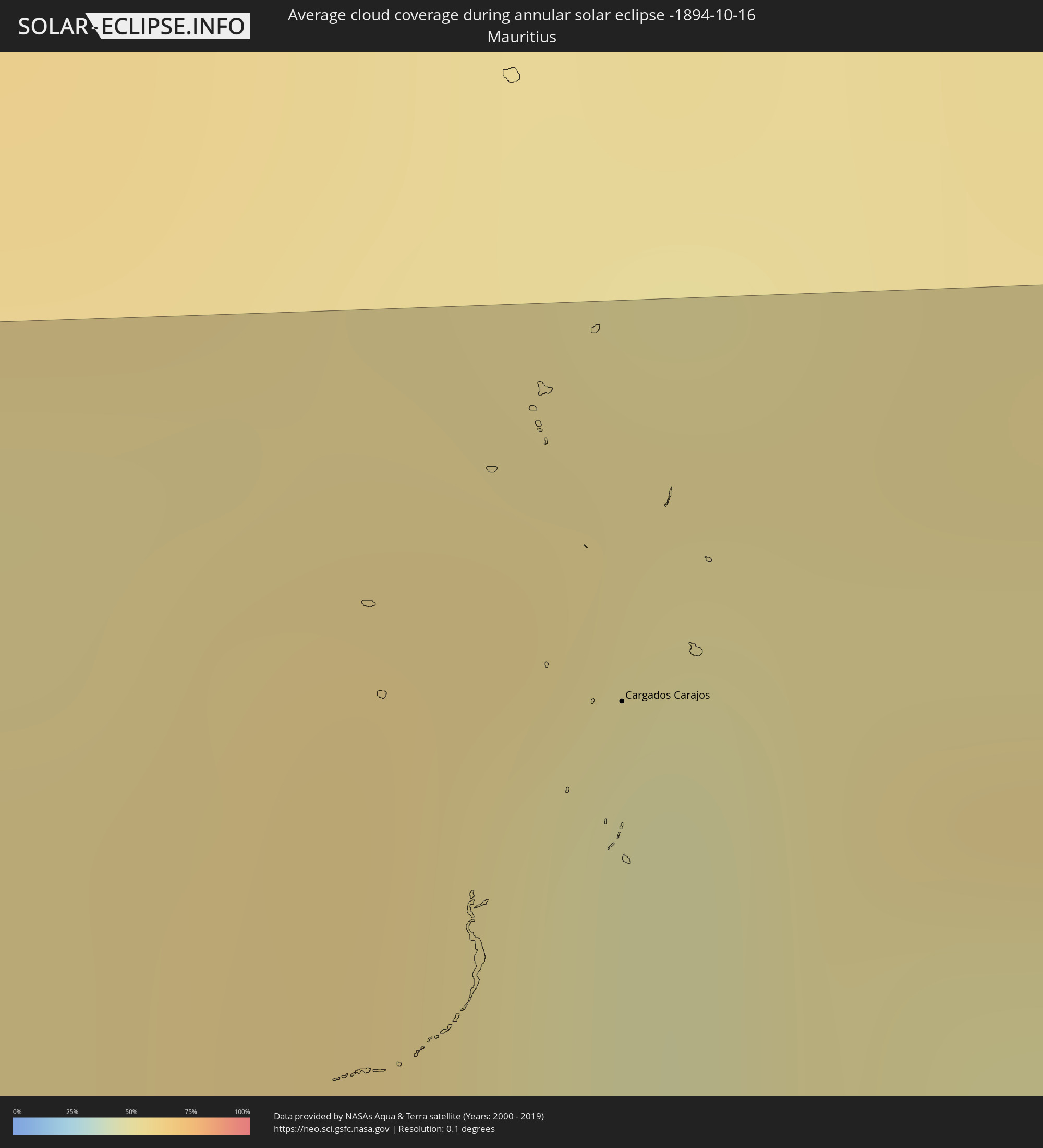 Mauritius
Cities inside the path of the eclipse
The following table shows all locations with a population of more than 5,000 inside the eclipse path. Cities which have more than 100,000 inhabitants are marked bold. A click at the locations opens a detailed map.
| City | Type | Eclipse duration | Local time of max. eclipse | Distance to central line | Ø Cloud coverage |
|
Freetown, Western Area
|
annular | - | 10:21:54 UTC-00:16 | 45 km | 82% |
|
Freetown, Western Area
|
annular | - | 10:21:57 UTC-00:16 | 53 km | 85% |
|
Tintafor, Northern Province
|
annular | - | 10:21:47 UTC-00:16 | 68 km | 75% |
|
Kassiri, Northern Province
|
annular | - | 10:21:34 UTC-00:16 | 104 km | 82% |
|
Waterloo, Western Area
|
annular | - | 10:22:32 UTC-00:16 | 48 km | 85% |
|
Mambolo, Northern Province
|
annular | - | 10:21:46 UTC-00:16 | 106 km | 83% |
|
Port Loko, Northern Province
|
annular | - | 10:22:34 UTC-00:16 | 104 km | 88% |
|
Lunsar, Northern Province
|
annular | - | 10:23:16 UTC-00:16 | 109 km | 86% |
|
Bonthe, Southern Province
|
annular | - | 10:25:04 UTC-00:16 | 2 km | 82% |
|
Moyamba, Southern Province
|
annular | - | 10:24:17 UTC-00:16 | 64 km | 86% |
|
Rokupr, Northern Province
|
annular | - | 10:23:38 UTC-00:16 | 116 km | 86% |
|
Sumbuya, Southern Province
|
annular | - | 10:26:10 UTC-00:16 | 39 km | 83% |
|
Bumpe, Southern Province
|
annular | - | 10:25:55 UTC-00:16 | 66 km | 85% |
|
Gandorhun, Southern Province
|
annular | - | 10:26:43 UTC-00:16 | 31 km | 90% |
|
Bo, Southern Province
|
annular | - | 10:26:12 UTC-00:16 | 82 km | 87% |
|
Pujehun, Southern Province
|
annular | - | 10:27:11 UTC-00:16 | 24 km | 90% |
|
Baoma, Southern Province
|
annular | - | 10:26:13 UTC-00:16 | 86 km | 87% |
|
Gandorhun, Southern Province
|
annular | - | 10:26:57 UTC-00:16 | 44 km | 89% |
|
Mamboma, Southern Province
|
annular | - | 10:26:08 UTC-00:16 | 96 km | 86% |
|
Foindu, Southern Province
|
annular | - | 10:27:32 UTC-00:16 | 38 km | 85% |
|
Bomi, Southern Province
|
annular | - | 10:27:50 UTC-00:16 | 23 km | 87% |
|
Robertsport, Grand Cape Mount
|
annular | - | 10:02:00 UTC-00:43 | 16 km | 80% |
|
Blama, Eastern Province
|
annular | - | 10:27:17 UTC-00:16 | 94 km | 84% |
|
Kenema, Eastern Province
|
annular | - | 10:27:39 UTC-00:16 | 103 km | 82% |
|
Tubmanburg, Bomi
|
annular | - | 10:03:09 UTC-00:43 | 26 km | 90% |
|
Monrovia, Montserrado
|
annular | - | 10:04:08 UTC-00:43 | 28 km | 82% |
|
Bensonville, Montserrado
|
annular | - | 10:04:21 UTC-00:43 | 4 km | 93% |
|
Bopolu, Gbarpolu
|
annular | - | 10:03:39 UTC-00:43 | 63 km | 86% |
|
Kakata, Margibi
|
annular | - | 10:04:52 UTC-00:43 | 19 km | 94% |
|
Buchanan, Grand Bassa
|
annular | - | 10:06:44 UTC-00:43 | 26 km | 88% |
|
Cestos City, River Cess
|
annular | - | 10:08:38 UTC-00:43 | 40 km | 85% |
|
Gbarnga, Bong
|
annular | - | 10:06:18 UTC-00:43 | 113 km | 88% |
|
Greenville, Sinoe
|
annular | - | 10:10:49 UTC-00:43 | 51 km | 86% |
|
Barclayville, Grand Kru
|
annular | - | 10:13:32 UTC-00:43 | 36 km | 95% |
|
Zwedru, Grand Gedeh
|
annular | - | 10:11:19 UTC-00:43 | 101 km | 84% |
|
Fish Town, River Gee
|
annular | - | 10:13:33 UTC-00:43 | 34 km | 87% |
|
Harper, Maryland
|
annular | - | 10:15:28 UTC-00:43 | 33 km | 83% |
|
Tabou, Bas-Sassandra
|
annular | - | 10:43:21 UTC-00:16 | 8 km | 74% |
|
San-Pédro, Bas-Sassandra
|
annular | - | 10:44:41 UTC-00:16 | 66 km | 62% |
|
Sassandra, Bas-Sassandra
|
annular | - | 10:45:49 UTC-00:16 | 118 km | 69% |
|
Luanda, Luanda
|
annular | - | 12:40:58 UTC+00:13 | 21 km | 82% |
|
Caxito, Bengo
|
annular | - | 12:41:45 UTC+00:13 | 69 km | 94% |
|
N’dalatando, Cuanza Norte
|
annular | - | 12:46:26 UTC+00:13 | 62 km | 80% |
|
Quibala, Kwanza Sul
|
annular | - | 12:48:51 UTC+00:13 | 77 km | 58% |
|
Malanje, Malanje
|
annular | - | 12:50:43 UTC+00:13 | 108 km | 73% |
|
Catabola, Bíe
|
annular | - | 12:56:55 UTC+00:13 | 111 km | 51% |
|
Chissamba, Bíe
|
annular | - | 12:57:04 UTC+00:13 | 111 km | 51% |
|
Camacupa, Bíe
|
annular | - | 12:57:15 UTC+00:13 | 89 km | 54% |
|
Luena, Moxico
|
annular | - | 13:03:00 UTC+00:13 | 40 km | 62% |
|
Léua, Moxico
|
annular | - | 13:04:07 UTC+00:13 | 75 km | 56% |
|
Zambezi, North-Western
|
annular | - | 15:09:04 UTC+02:10 | 21 km | 41% |
|
Mufumbwe, North-Western
|
annular | - | 15:12:49 UTC+02:10 | 22 km | 30% |
|
Kaoma, Western
|
annular | - | 15:13:48 UTC+02:10 | 95 km | 27% |
|
Kalengwa, North-Western
|
annular | - | 15:13:02 UTC+02:10 | 52 km | 33% |
|
Kasempa, North-Western
|
annular | - | 15:14:44 UTC+02:10 | 79 km | 32% |
|
Mumbwa, Central
|
annular | - | 15:18:24 UTC+02:10 | 46 km | 27% |
|
Mazabuka, Southern
|
annular | - | 15:20:18 UTC+02:10 | 120 km | 24% |
|
Nakambala, Southern
|
annular | - | 15:20:21 UTC+02:10 | 117 km | 23% |
|
Lusaka, Lusaka
|
annular | - | 15:20:58 UTC+02:10 | 57 km | 25% |
|
Kapiri Mposhi, Central
|
annular | - | 15:20:38 UTC+02:10 | 108 km | 31% |
|
Tete, Tete
|
annular | - | 15:30:04 UTC+02:10 | 13 km | 28% |
|
Mwanza, Southern Region
|
annular | - | 15:31:09 UTC+02:10 | 66 km | 33% |
|
Chikwawa, Southern Region
|
annular | - | 15:31:45 UTC+02:10 | 24 km | 30% |
|
Blantyre, Southern Region
|
annular | - | 15:31:55 UTC+02:10 | 55 km | 48% |
|
Thyolo, Southern Region
|
annular | - | 15:32:14 UTC+02:10 | 26 km | 40% |
|
Nsanje, Southern Region
|
annular | - | 15:32:45 UTC+02:10 | 65 km | 36% |
|
Luchenza, Southern Region
|
annular | - | 15:32:26 UTC+02:10 | 36 km | 39% |
|
Zomba, Southern Region
|
annular | - | 15:32:10 UTC+02:10 | 104 km | 31% |
|
Mulanje, Southern Region
|
annular | - | 15:32:42 UTC+02:10 | 37 km | 42% |
|
António Enes, Nampula
|
annular | - | 15:38:11 UTC+02:10 | 82 km | 31% |
|
Maintirano, Melaky
|
annular | - | 15:59:31 UTC+02:27 | 77 km | 29% |
|
Mahabe, Melaky
|
annular | - | 16:00:26 UTC+02:27 | 42 km | 43% |
|
Sitampiky, Boeny
|
annular | - | 16:00:58 UTC+02:27 | 94 km | 35% |
|
Fenoarivo Be, Bongolava
|
annular | - | 16:01:32 UTC+02:27 | 100 km | 27% |
|
Ambato Boeny, Boeny
|
annular | - | 16:01:24 UTC+02:27 | 120 km | 30% |
|
Maevatanana, Betsiboka
|
annular | - | 16:01:34 UTC+02:27 | 67 km | 26% |
|
Ankazobe, Analamanga
|
annular | - | 16:01:55 UTC+02:27 | 83 km | 35% |
|
Tsaratanana, Betsiboka
|
annular | - | 16:02:07 UTC+02:27 | 89 km | 32% |
|
Ambohitrolomahitsy, Analamanga
|
annular | - | 16:02:20 UTC+02:27 | 123 km | 41% |
|
Sadabe, Analamanga
|
annular | - | 16:02:20 UTC+02:27 | 115 km | 40% |
|
Ankazondandy, Analamanga
|
annular | - | 16:02:24 UTC+02:27 | 122 km | 47% |
|
Anjozorobe, Analamanga
|
annular | - | 16:02:26 UTC+02:27 | 88 km | 50% |
|
Amparafaravola, Alaotra Mangoro
|
annular | - | 16:02:36 UTC+02:27 | 4 km | 53% |
|
Ambatondrazaka, Alaotra Mangoro
|
annular | - | 16:02:44 UTC+02:27 | 23 km | 55% |
|
Andilamena, Alaotra Mangoro
|
annular | - | 16:02:45 UTC+02:27 | 70 km | 58% |
|
Sahatavy, Analanjirofo
|
annular | - | 16:03:04 UTC+02:27 | 23 km | 81% |
|
Vohibinany, Atsinanana
|
annular | - | 16:03:05 UTC+02:27 | 34 km | 79% |
|
Ampasimanolotra, Atsinanana
|
annular | - | 16:03:12 UTC+02:27 | 129 km | 51% |
|
Vavatenina, Analanjirofo
|
annular | - | 16:03:12 UTC+02:27 | 21 km | 79% |
|
Toamasina, Atsinanana
|
annular | - | 16:03:22 UTC+02:27 | 54 km | 57% |
|
Fenoarivo Atsinanana, Analanjirofo
|
annular | - | 16:03:19 UTC+02:27 | 32 km | 60% |
|
Soanierana Ivongo, Analanjirofo
|
annular | - | 16:03:22 UTC+02:27 | 84 km | 59% |
|
Ambodifotatra, Analanjirofo
|
annular | - | 16:03:32 UTC+02:27 | 78 km | 56% |
|
Cargados Carajos, Cargados Carajos
|
annular | - | 17:29:53 UTC+03:50 | 120 km | 46% |