Total solar eclipse of 06/10/0001
| Day of week: | Sunday |
| Maximum duration of eclipse: | 04m56s |
| Maximum width of eclipse path: | 218 km |
| Saros cycle: | 66 |
| Coverage: | 100% |
| Magnitude: | 1.0617 |
| Gamma: | 0.3625 |
Wo kann man die Sonnenfinsternis vom 06/10/0001 sehen?
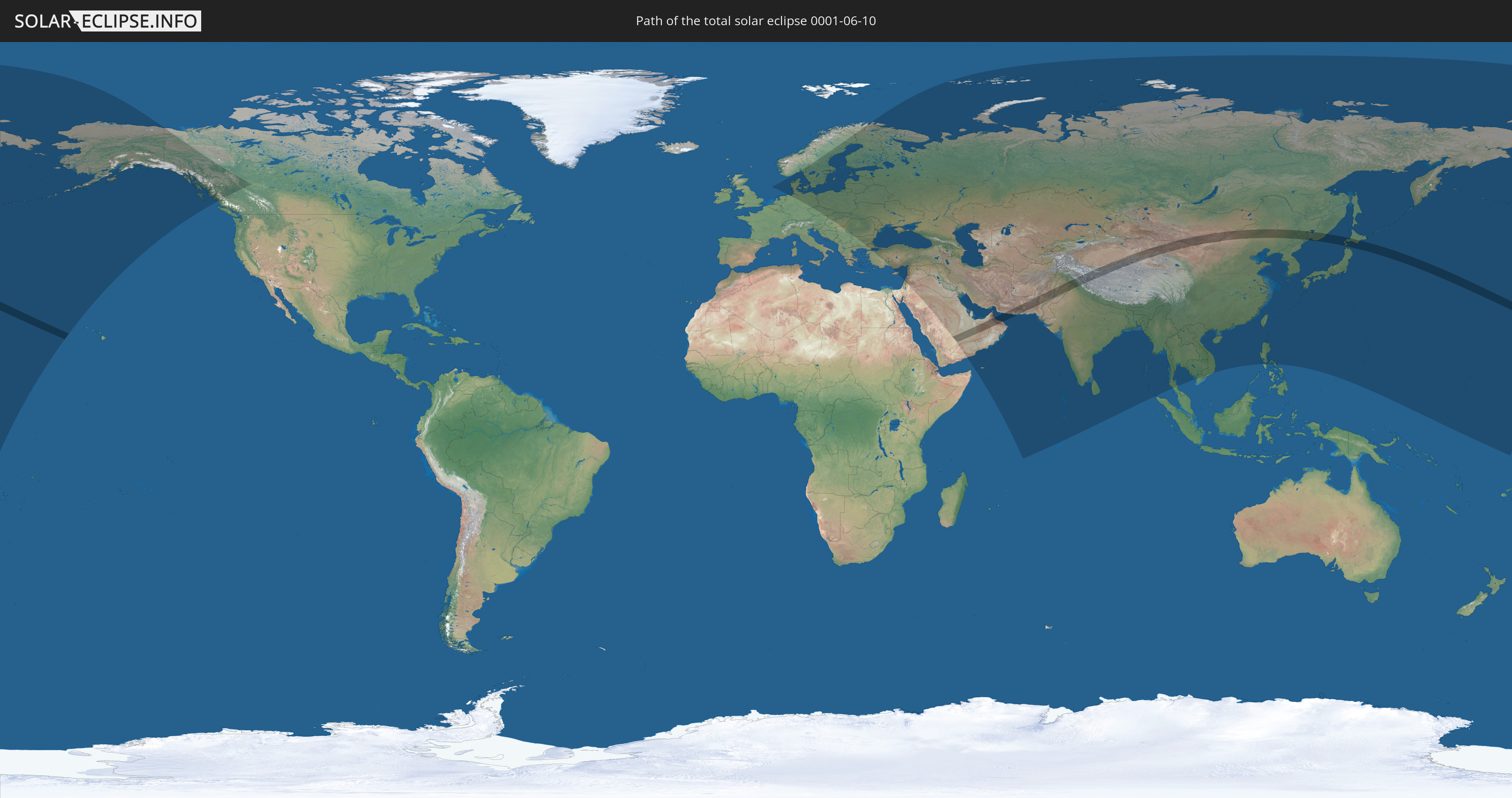
Die Sonnenfinsternis am 06/10/0001 kann man in 79 Ländern als partielle Sonnenfinsternis beobachten.
Der Finsternispfad verläuft durch 10 Länder. Nur in diesen Ländern ist sie als total Sonnenfinsternis zu sehen.
In den folgenden Ländern ist die Sonnenfinsternis total zu sehen
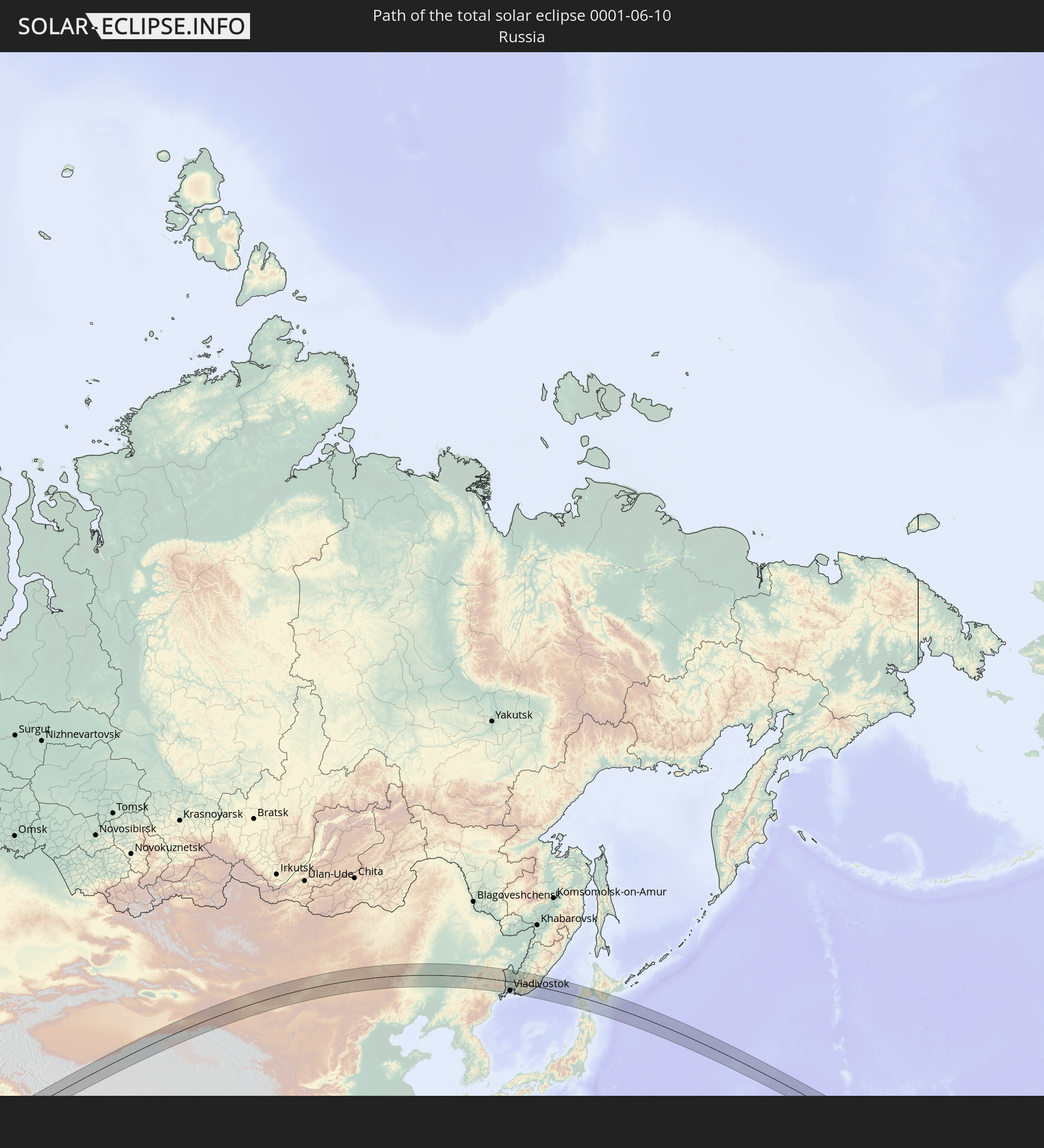 Russia
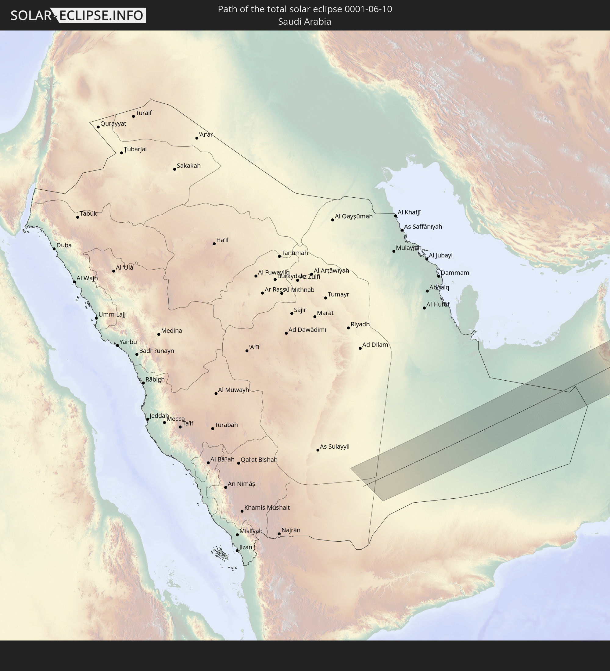 Saudi Arabia
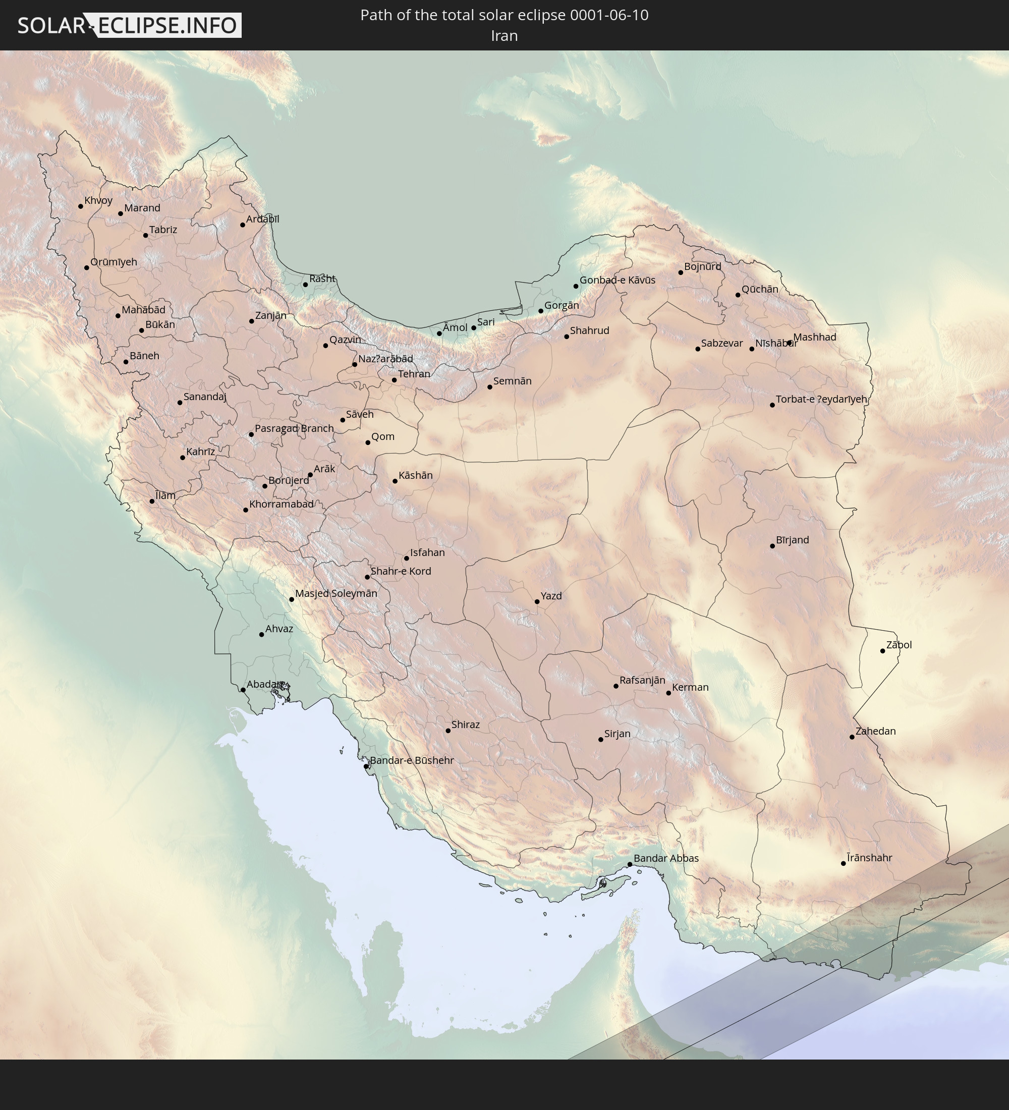 Iran
Iran
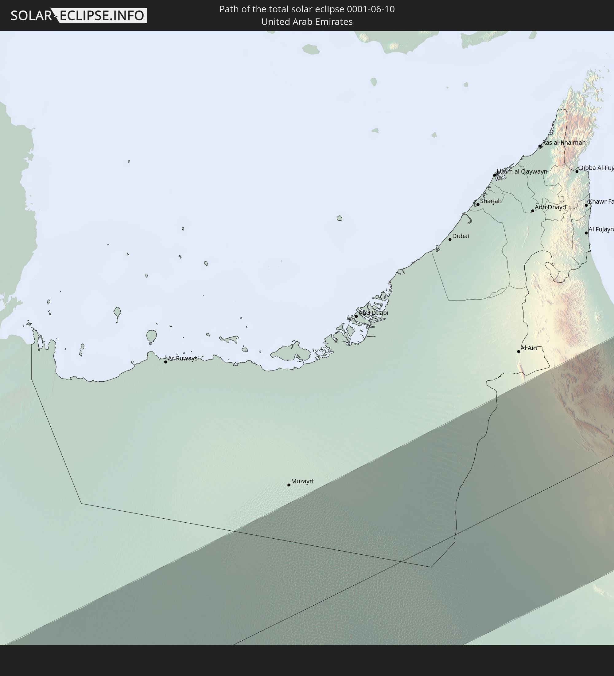 United Arab Emirates
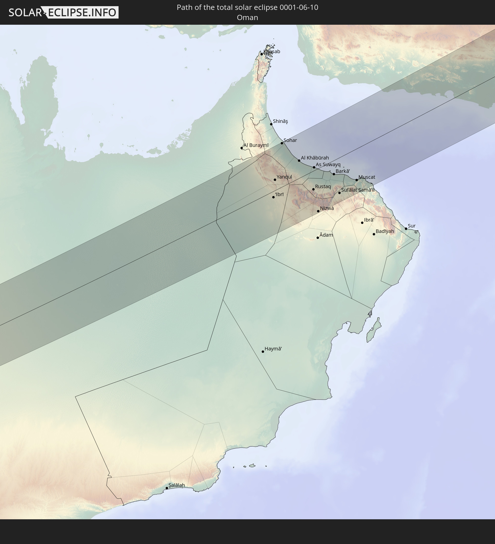 Oman
Oman
 Pakistan
 India
India
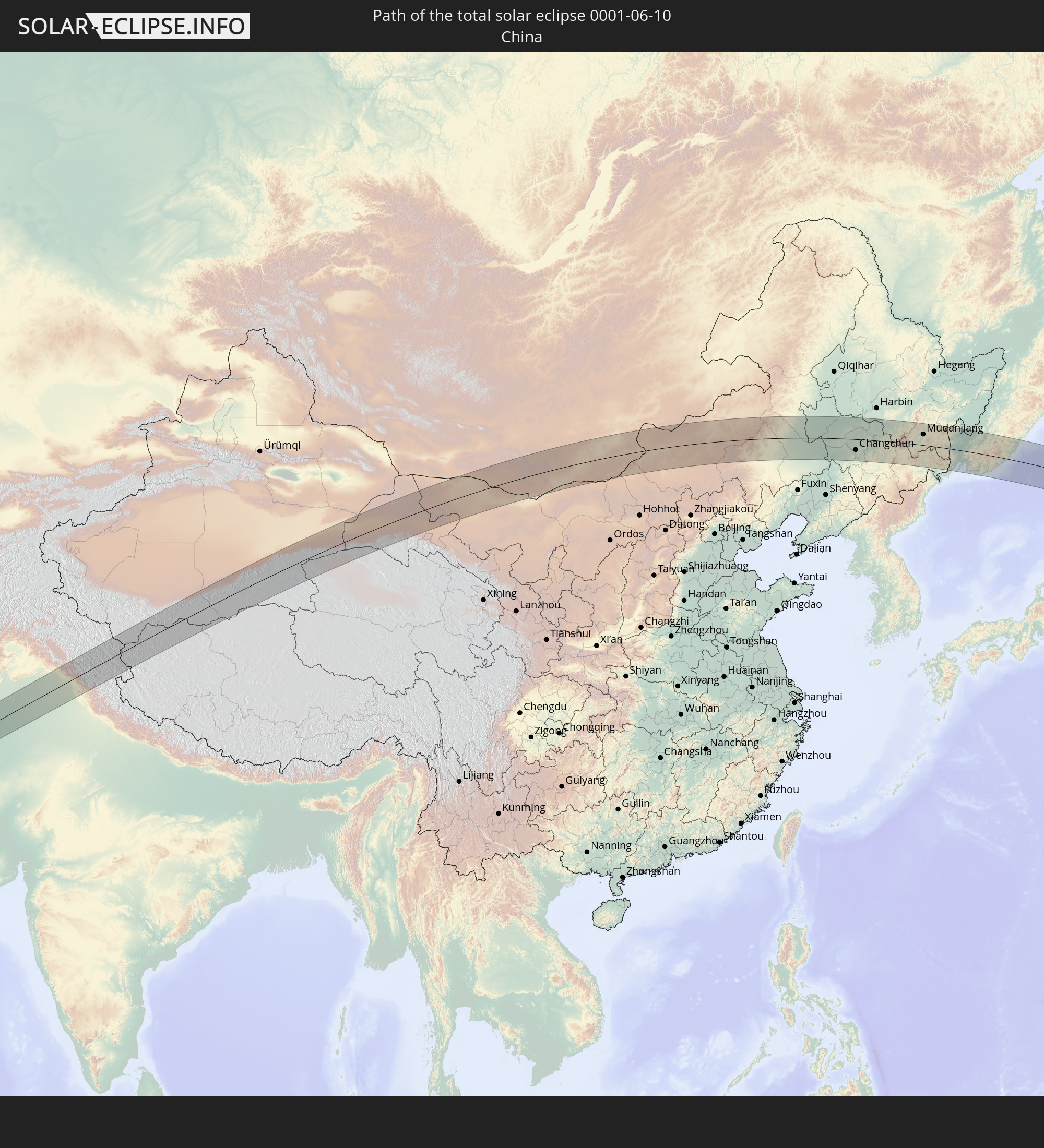 China
China
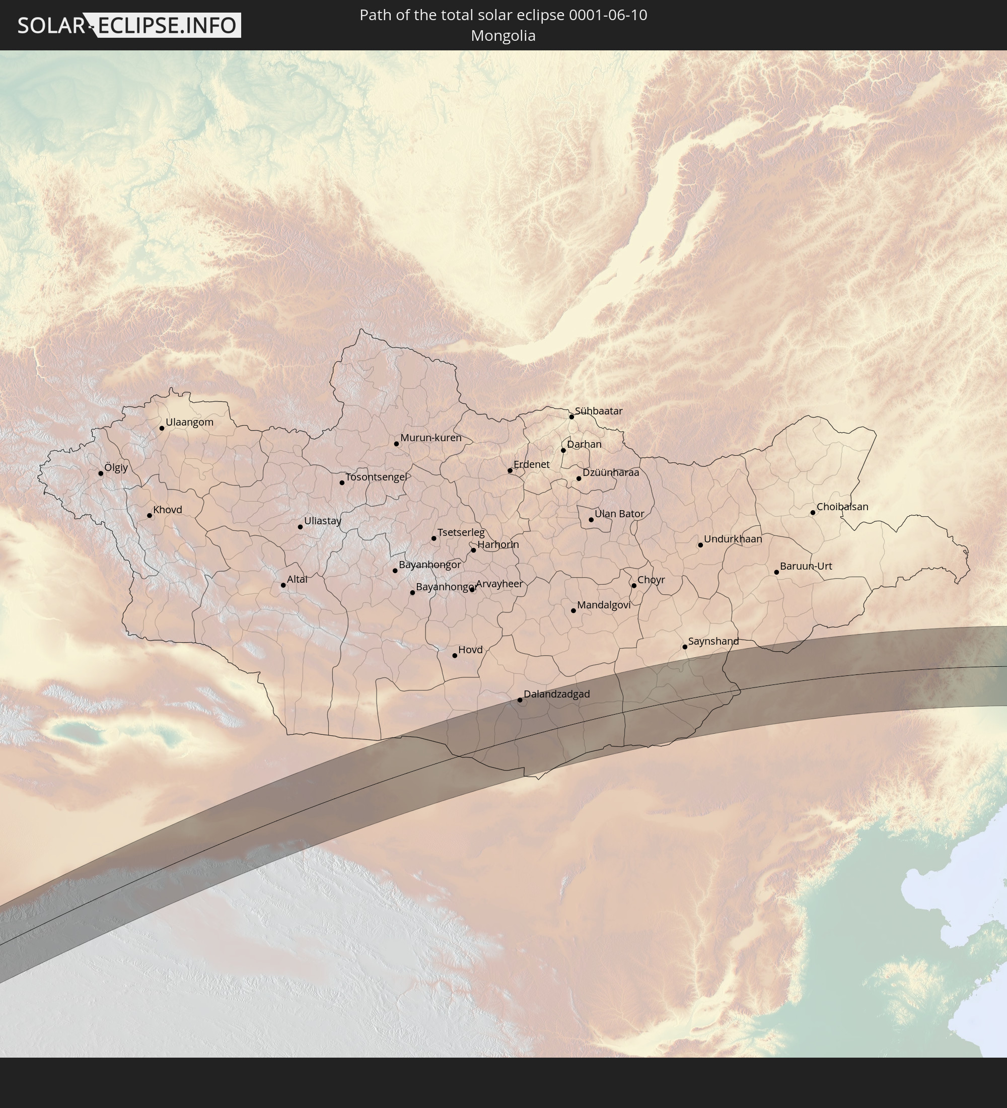 Mongolia
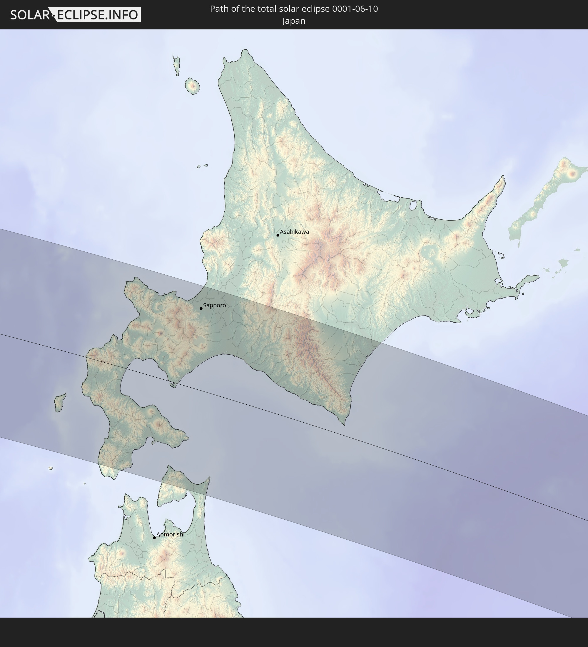 Japan
Japan
In den folgenden Ländern ist die Sonnenfinsternis partiell zu sehen
 Russia
 United States
 United States Minor Outlying Islands
 Kiribati
 Canada
 Norway
 Germany
 Denmark
 Austria
 Sweden
 Czechia
 Poland
 Hungary
 Slovakia
 Serbia
 Åland Islands
 Greece
 Romania
 Finland
 Lithuania
 Latvia
 Estonia
 Ukraine
 Bulgaria
 Belarus
 Turkey
 Moldova
 Cyprus
 Israel
 Saudi Arabia
 Jordan
 Lebanon
 Syria
Syria
 Iraq
Iraq
 Georgia
 Yemen
Yemen
 Armenia
 Iran
Iran
 Azerbaijan
 Kazakhstan
 Kuwait
 Bahrain
 Qatar
Qatar
 United Arab Emirates
 Oman
Oman
 Turkmenistan
 Uzbekistan
 Afghanistan
 Pakistan
 Tajikistan
 India
India
 Kyrgyzstan
 British Indian Ocean Territory
 Maldives
 China
China
 Sri Lanka
 Nepal
Nepal
 Mongolia
 Bangladesh
 Bhutan
 Myanmar
 Indonesia
 Thailand
 Laos
Laos
 Vietnam
 Cambodia
 Macau
Macau
 Hong Kong
 Taiwan
 Philippines
 Japan
Japan
 North Korea
 South Korea
 Federated States of Micronesia
 Guam
Guam
 Northern Mariana Islands
 Marshall Islands
 Nauru
Nauru
 Tuvalu
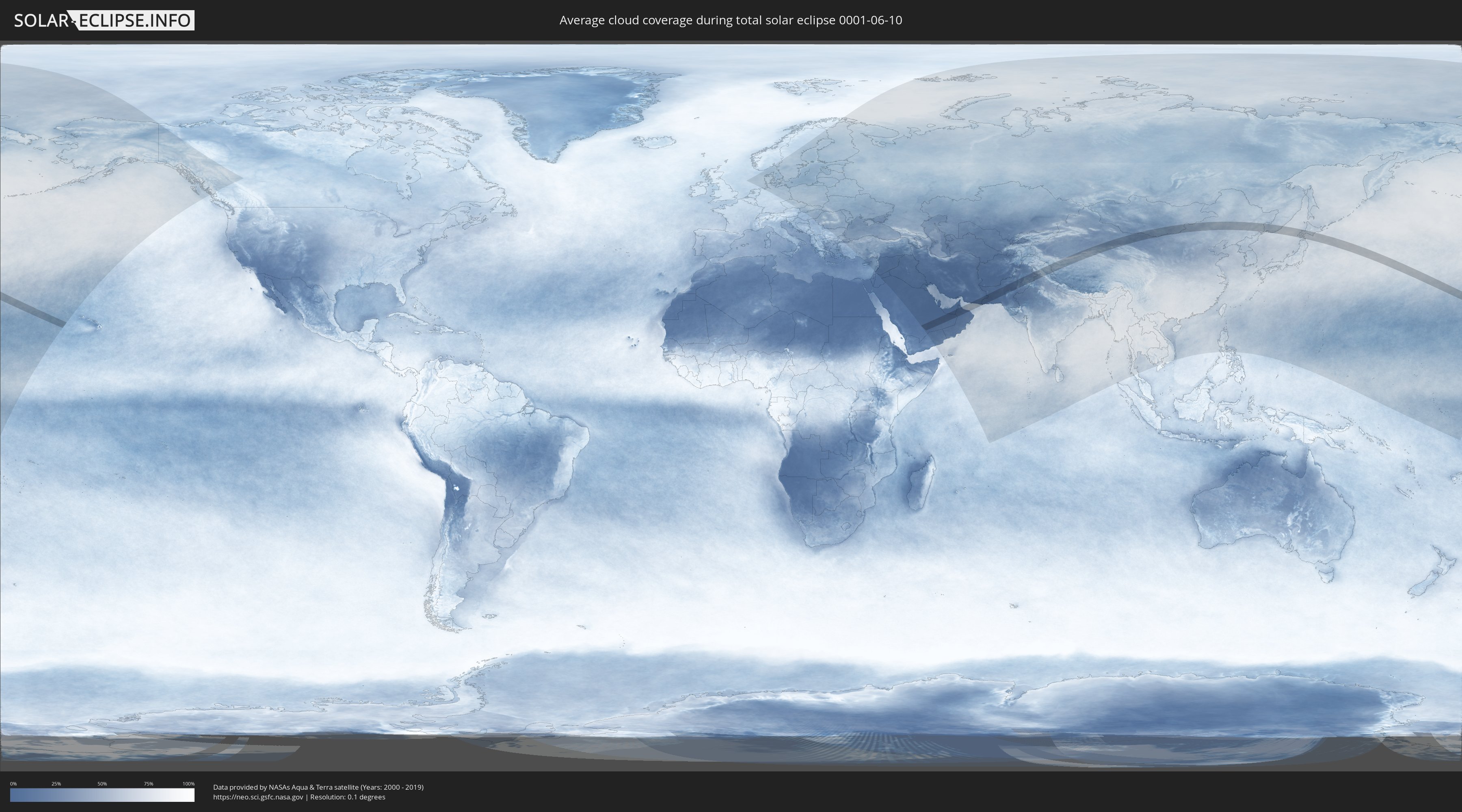
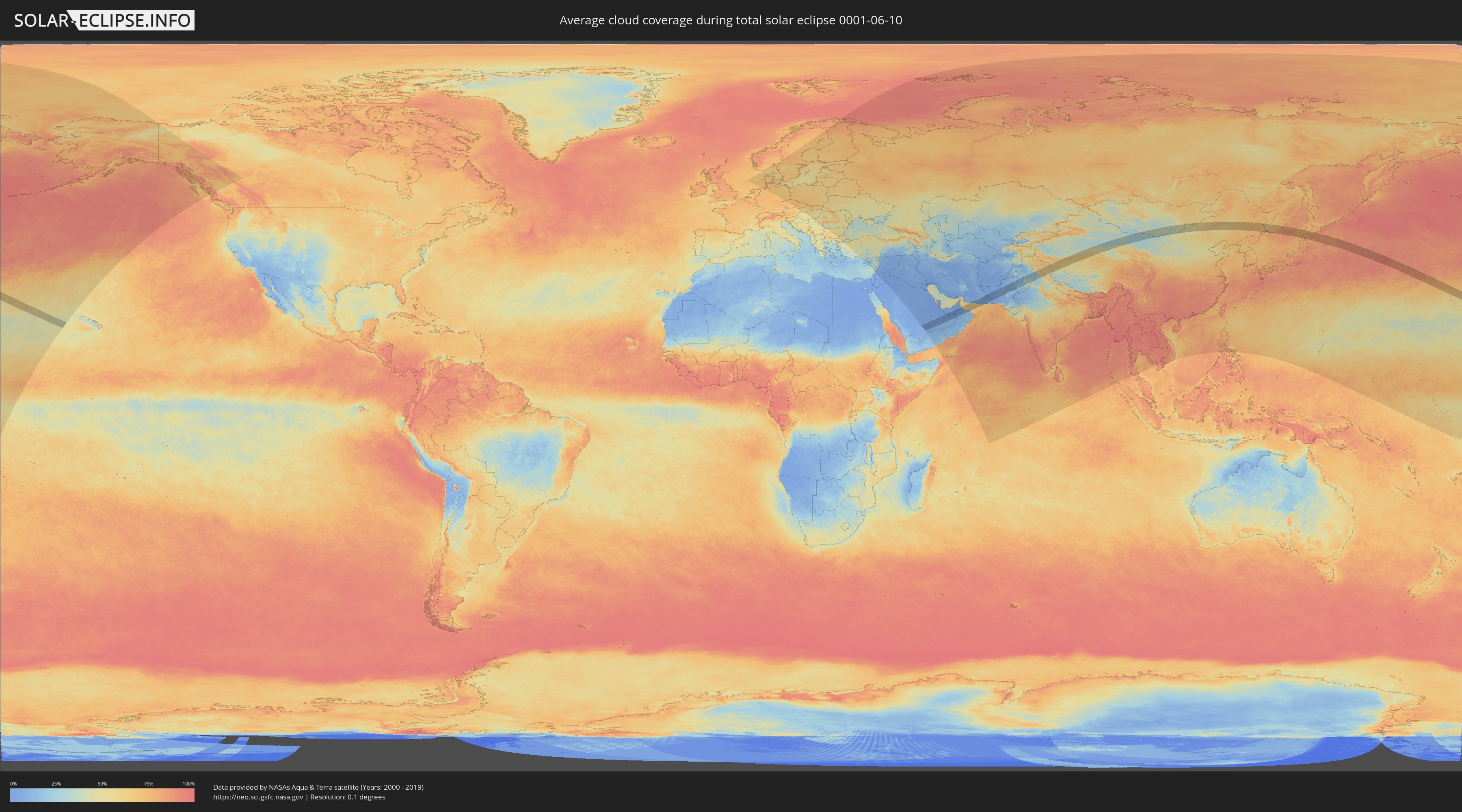
How will be the weather during the total solar eclipse on 06/10/0001?
Where is the best place to see the total solar eclipse of 06/10/0001?
The following maps show the average cloud coverage for the day of the total solar eclipse.
With the help of these maps, it is possible to find the place along the eclipse path, which has the best
chance of a cloudless sky.
Nevertheless, you should consider local circumstances and inform about the weather of your chosen
observation site.
The data is provided by NASAs satellites
AQUA and TERRA.
The cloud maps are averaged over a period of 19 years (2000 - 2019).
Detailed country maps
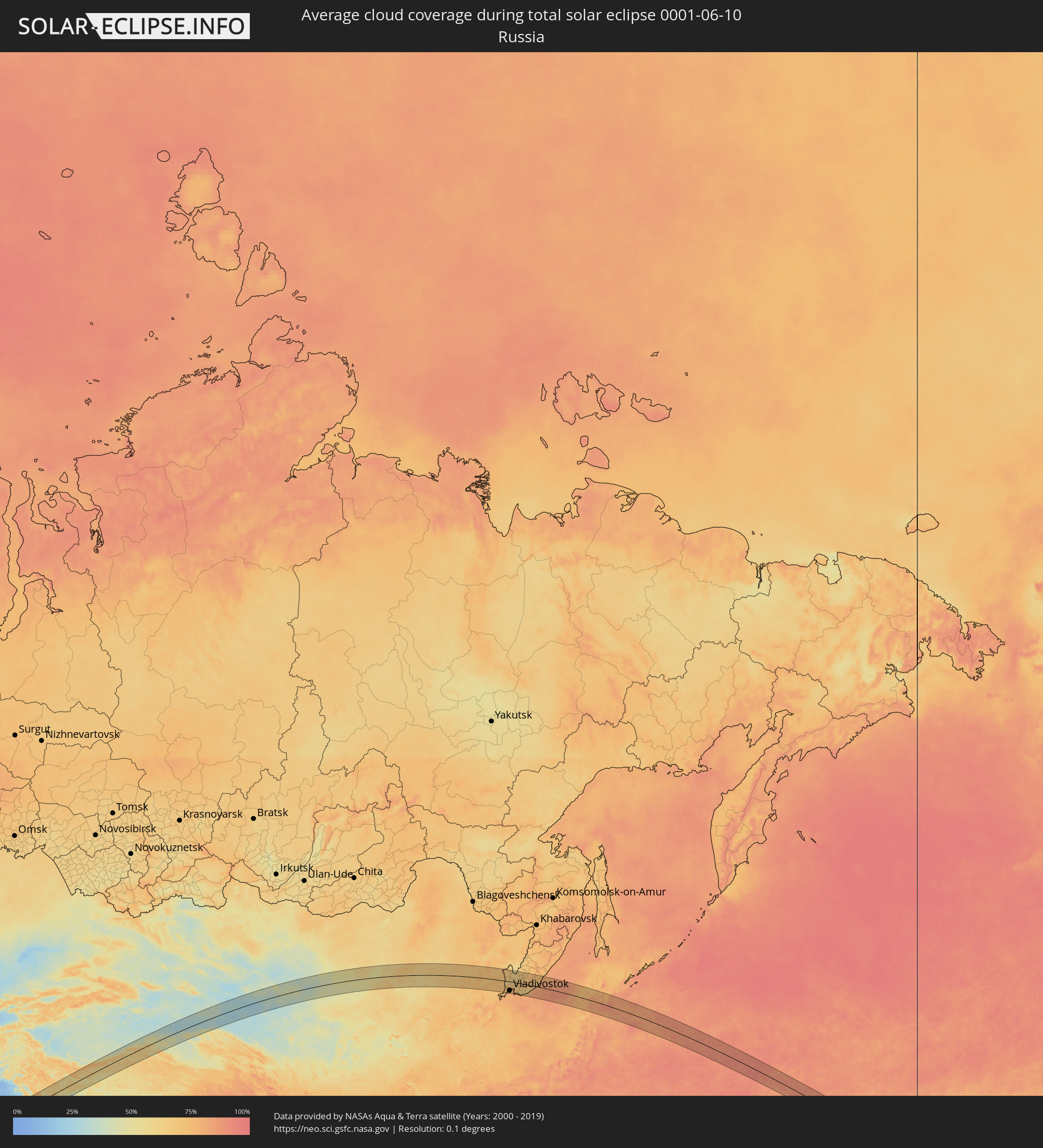 Russia
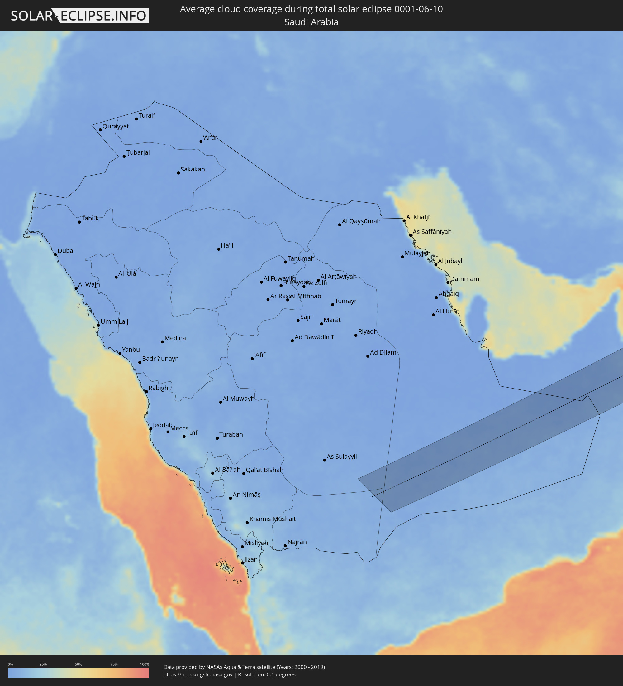 Saudi Arabia
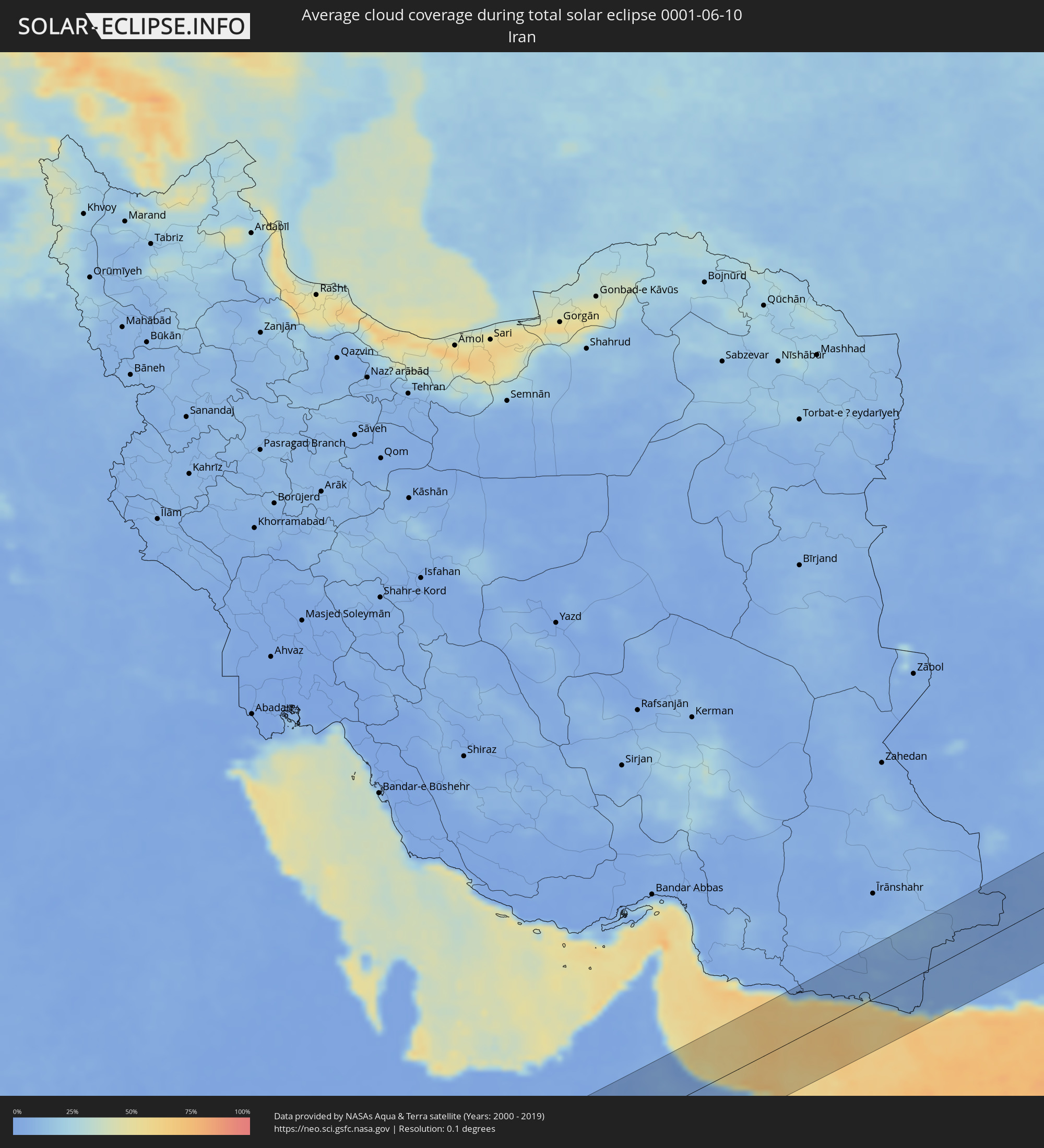 Iran
Iran
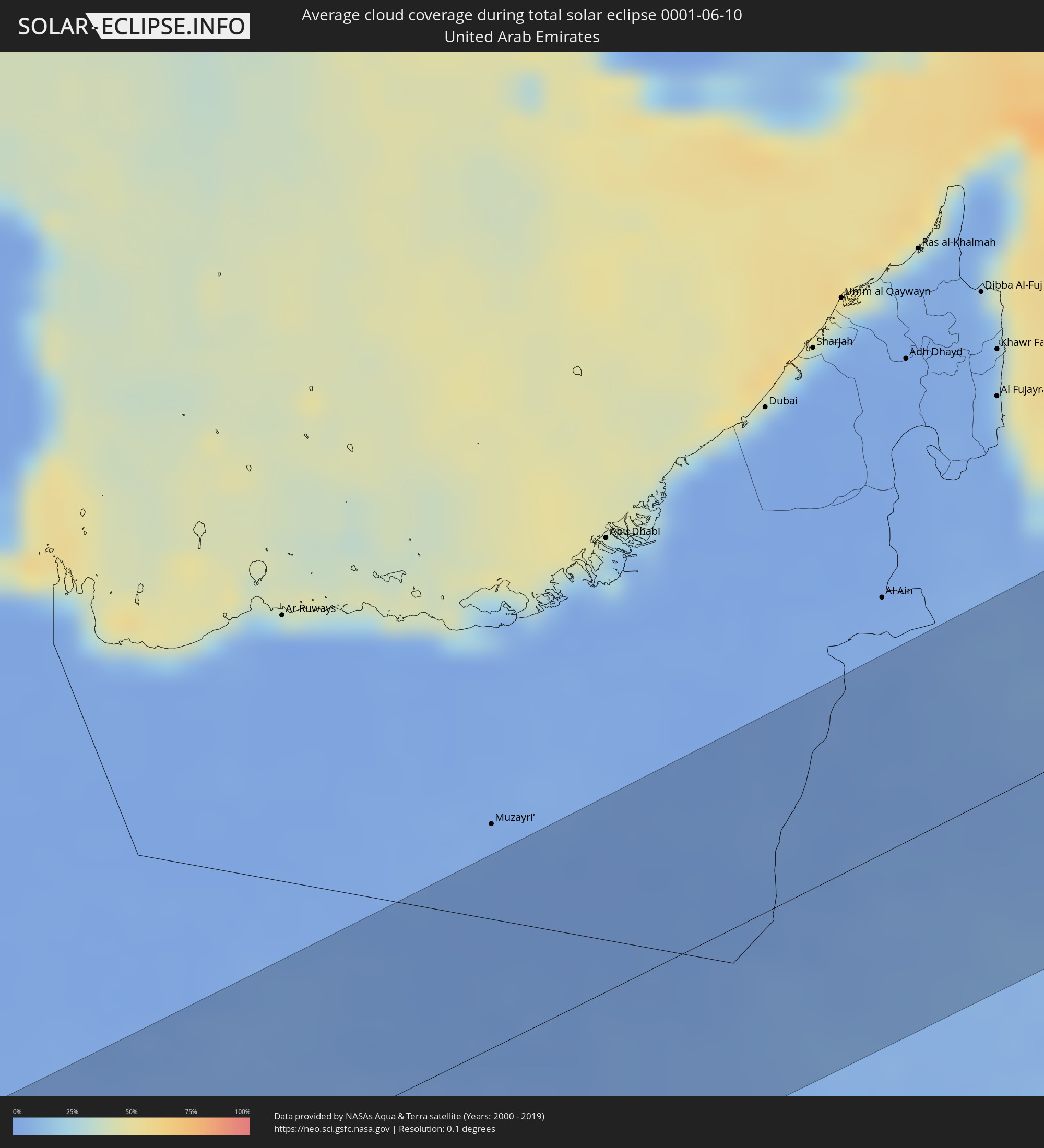 United Arab Emirates
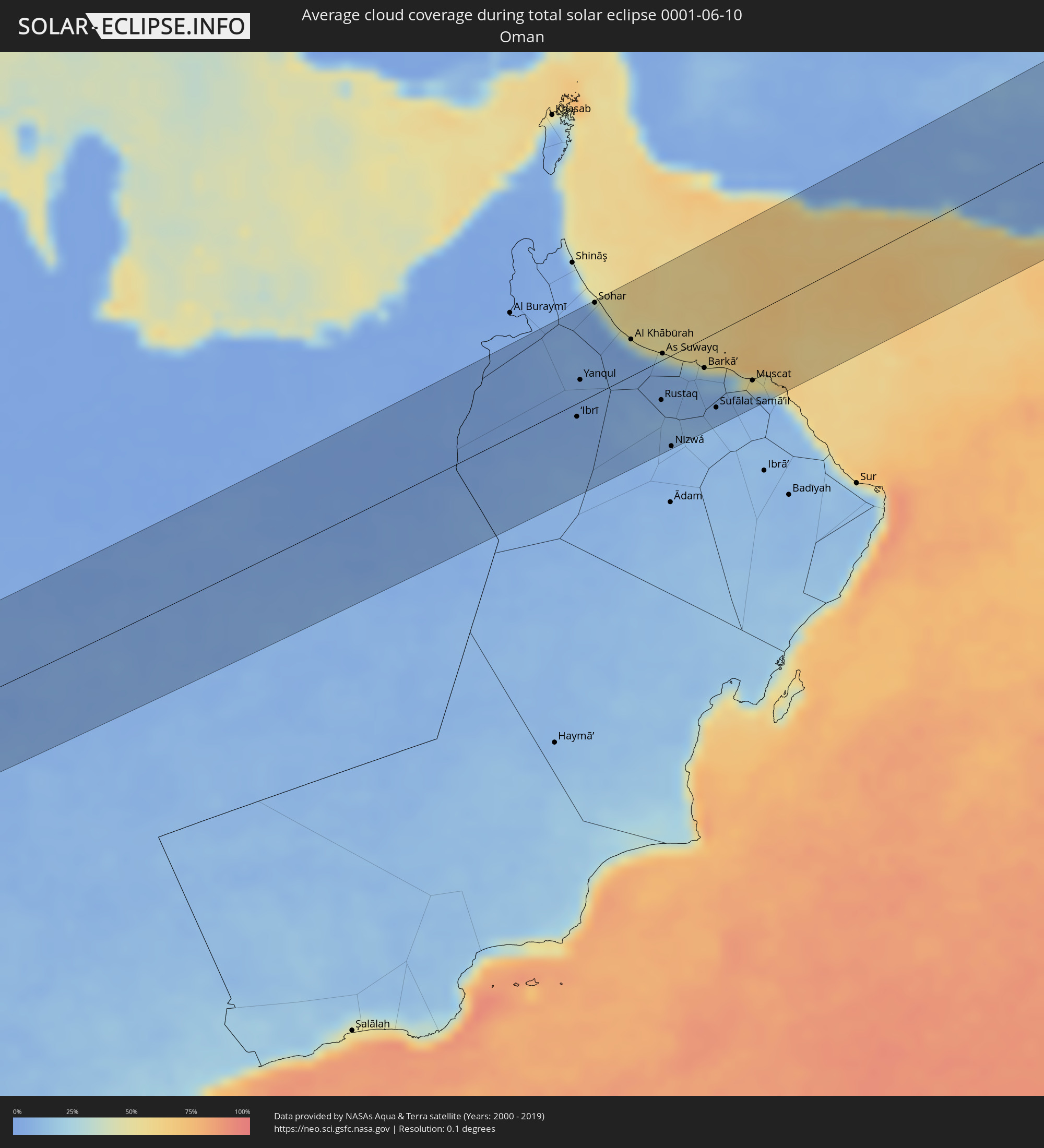 Oman
Oman
 Pakistan
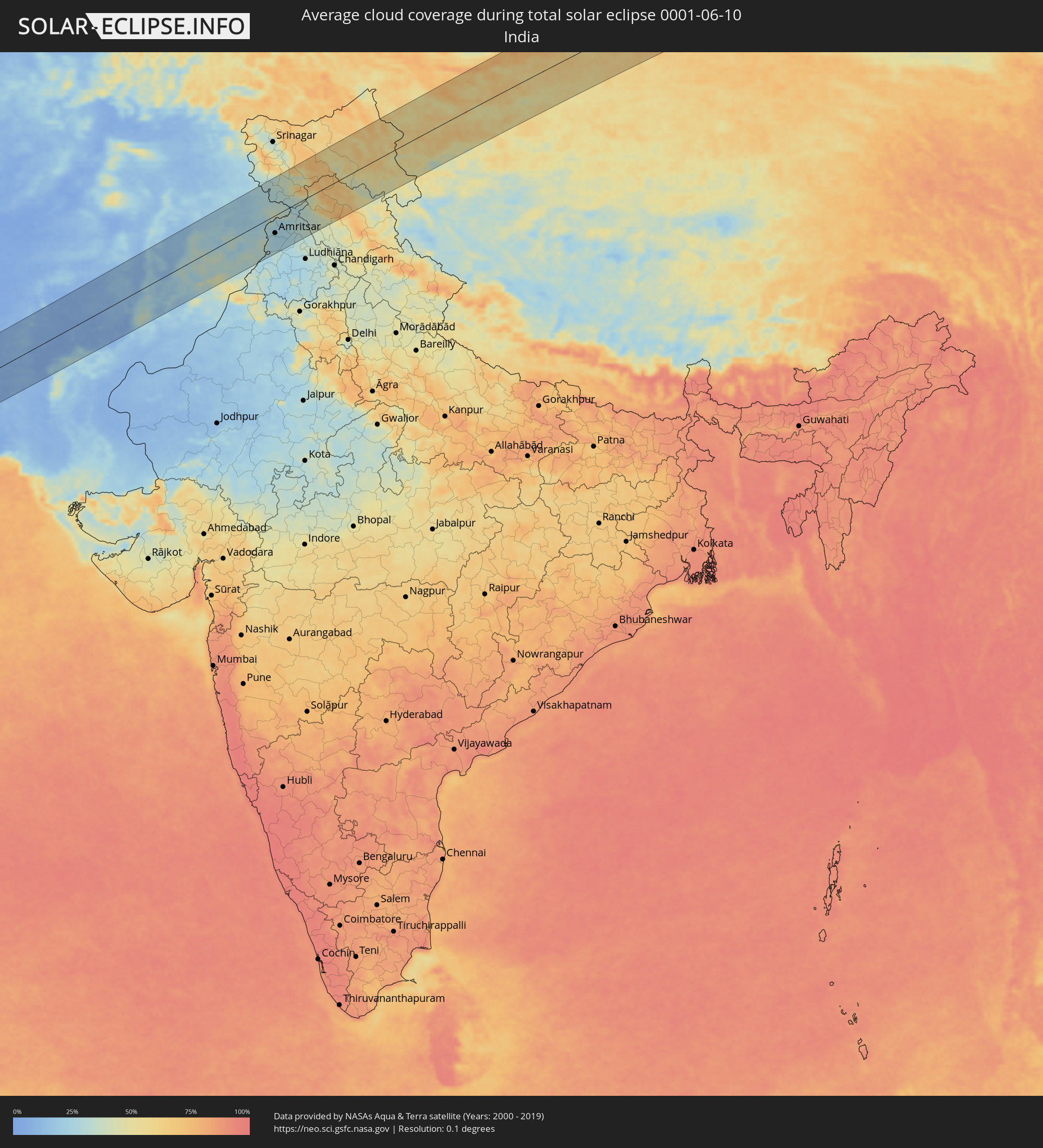 India
India
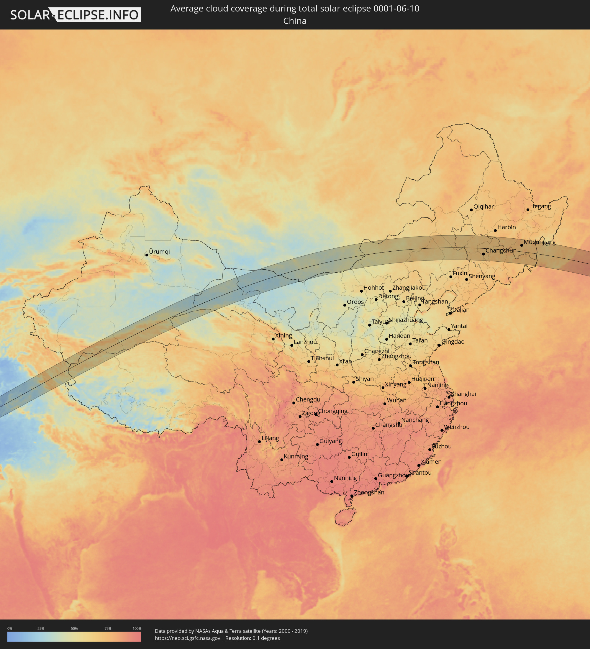 China
China
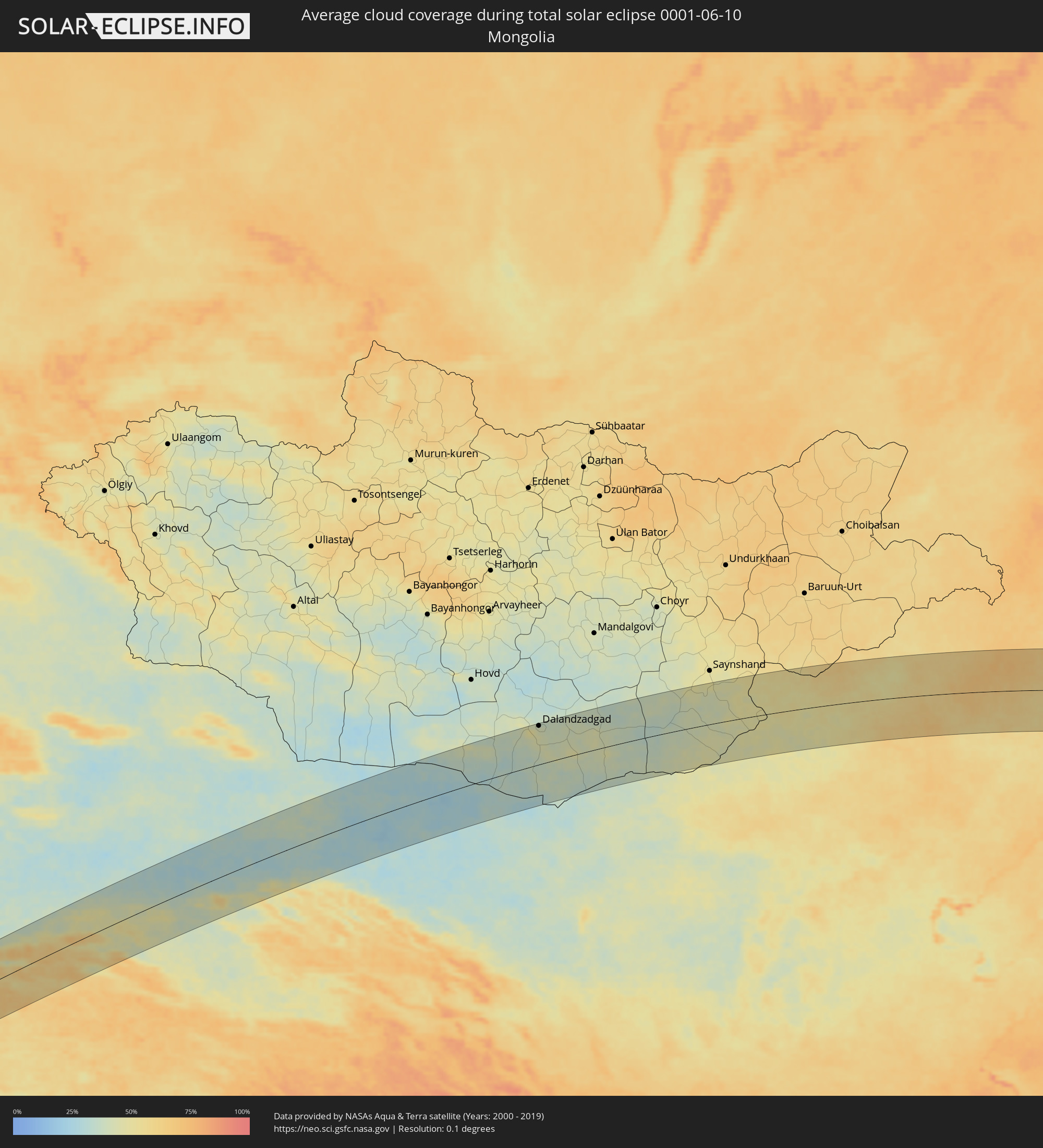 Mongolia
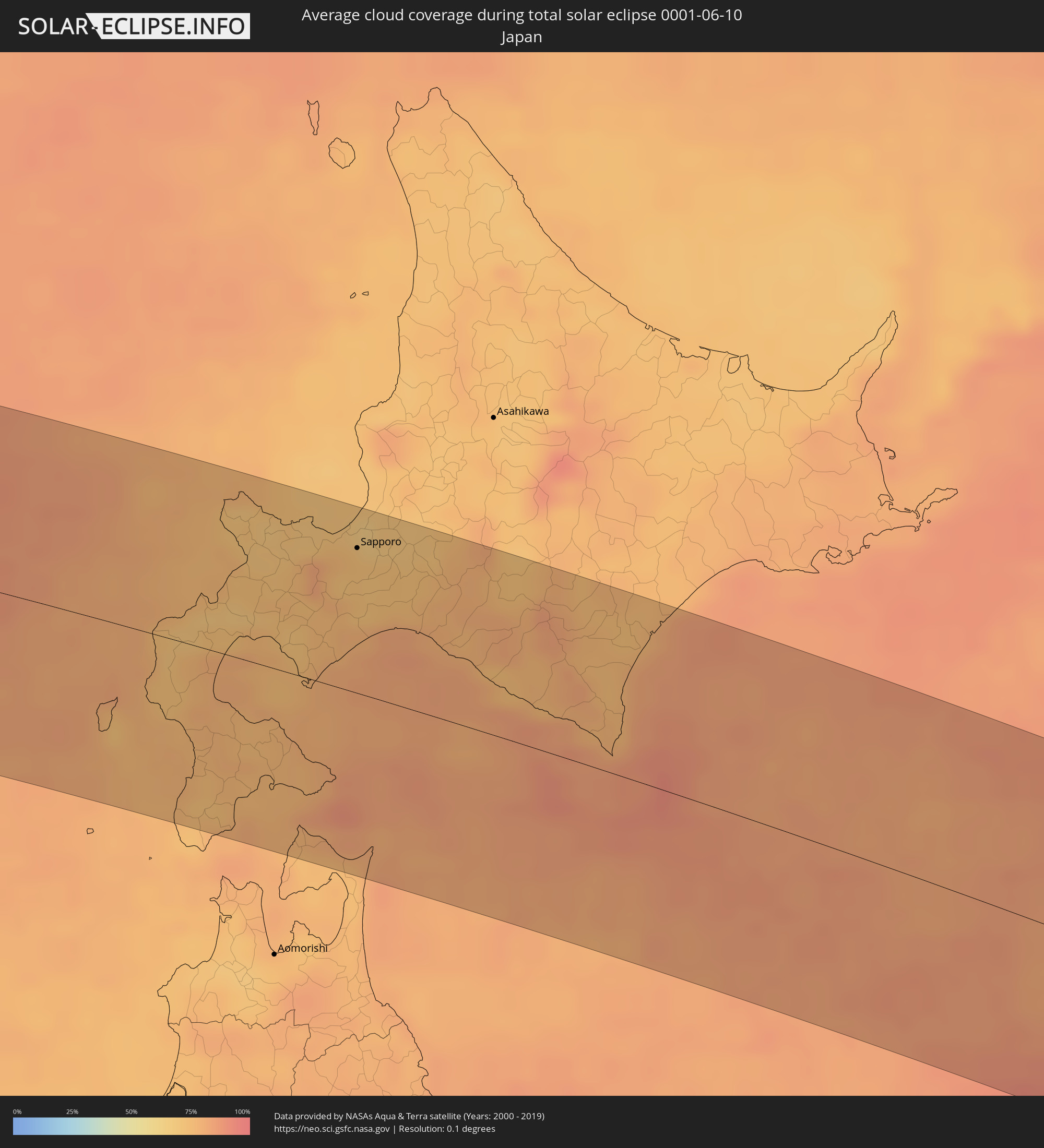 Japan
Japan
Cities inside the path of the eclipse
The following table shows all locations with a population of more than 5,000 inside the eclipse path. Cities which have more than 100,000 inhabitants are marked bold. A click at the locations opens a detailed map.
| City | Type | Eclipse duration | Local time of max. eclipse | Distance to central line | Ø Cloud coverage |
|
‘Ibrī, Az̧ Z̧āhirah
|
total | - | 05:54:13 UTC+03:41 | 13 km | 4% |
|
Yanqul, Az̧ Z̧āhirah
|
total | - | 05:54:34 UTC+03:41 | 22 km | 5% |
|
Sohar, Al Batinah North Governorate
|
total | - | 05:55:19 UTC+03:41 | 90 km | 12% |
|
Şaḩam, Al Batinah North Governorate
|
total | - | 05:55:07 UTC+03:41 | 64 km | 26% |
|
Al Khābūrah, Al Batinah North Governorate
|
total | - | 05:54:56 UTC+03:41 | 36 km | 16% |
|
Bahlā’, Muḩāfaz̧at ad Dākhilīyah
|
total | - | 05:53:56 UTC+03:41 | 74 km | 8% |
|
Rustaq, Al Batinah South Governorate
|
total | - | 05:54:19 UTC+03:41 | 39 km | 9% |
|
As Suwayq, Al Batinah North Governorate
|
total | - | 05:54:46 UTC+03:41 | 6 km | 6% |
|
Bayt al ‘Awābī, Al Batinah South Governorate
|
total | - | 05:54:14 UTC+03:41 | 52 km | 10% |
|
Nizwá, Muḩāfaz̧at ad Dākhilīyah
|
total | - | 05:53:52 UTC+03:41 | 89 km | 7% |
|
Barkā’, Al Batinah South Governorate
|
total | - | 05:54:37 UTC+03:41 | 29 km | 13% |
|
Sufālat Samā’il, Muḩāfaz̧at ad Dākhilīyah
|
total | - | 05:54:14 UTC+03:41 | 74 km | 9% |
|
Bidbid, Muḩāfaz̧at ad Dākhilīyah
|
total | - | 05:54:19 UTC+03:41 | 70 km | 7% |
|
Seeb, Muḩāfaz̧at Masqaţ
|
total | - | 05:54:34 UTC+03:41 | 47 km | 25% |
|
Bawshar, Muḩāfaz̧at Masqaţ
|
total | - | 05:54:27 UTC+03:41 | 68 km | 12% |
|
Muscat, Muḩāfaz̧at Masqaţ
|
total | - | 05:54:29 UTC+03:41 | 65 km | 12% |
|
Chabahar, Sistan and Baluchestan
|
total | - | 05:40:48 UTC+03:25 | 1 km | 58% |
|
Qaşr-e Qand, Sistan and Baluchestan
|
total | - | 05:41:49 UTC+03:25 | 88 km | 7% |
|
Khuzdār, Balochistān
|
total | - | 06:47:01 UTC+04:28 | 35 km | 8% |
|
Jacobābād, Sindh
|
total | - | 06:48:06 UTC+04:28 | 75 km | 20% |
|
Dera Ghazi Khan, Punjab
|
total | - | 06:51:06 UTC+04:28 | 4 km | 15% |
|
Muzaffargarh, Punjab
|
total | - | 06:51:22 UTC+04:28 | 28 km | 20% |
|
Multān, Punjab
|
total | - | 06:51:39 UTC+04:28 | 30 km | 21% |
|
Jhang Sadr, Punjab
|
total | - | 06:53:26 UTC+04:28 | 35 km | 33% |
|
Būrewāla, Punjab
|
total | - | 06:52:10 UTC+04:28 | 87 km | 30% |
|
Sargodha, Punjab
|
total | - | 06:54:40 UTC+04:28 | 99 km | 17% |
|
Gojra, Punjab
|
total | - | 06:53:27 UTC+04:28 | 7 km | 33% |
|
Chiniot, Punjab
|
total | - | 06:54:20 UTC+04:28 | 49 km | 25% |
|
Faisalābād, Punjab
|
total | - | 06:54:00 UTC+04:28 | 15 km | 23% |
|
Sahiwal, Punjab
|
total | - | 06:53:02 UTC+04:28 | 59 km | 32% |
|
Bahāwalnagar, Punjab
|
total | - | 06:53:02 UTC+04:28 | 84 km | 34% |
|
Okāra, Punjab
|
total | - | 06:53:24 UTC+04:28 | 61 km | 32% |
|
Shahkot, Punjab
|
total | - | 06:54:25 UTC+04:28 | 11 km | 30% |
|
Hāfizābād, Punjab
|
total | - | 06:55:10 UTC+04:28 | 50 km | 22% |
|
Sheikhupura, Punjab
|
total | - | 06:54:52 UTC+04:28 | 2 km | 26% |
|
Gujrāt, Punjab
|
total | - | 06:56:04 UTC+04:28 | 82 km | 22% |
|
Gujrānwāla, Punjab
|
total | - | 06:55:34 UTC+04:28 | 37 km | 25% |
|
Kamoke, Punjab
|
total | - | 06:55:21 UTC+04:28 | 17 km | 23% |
|
Murīdke, Punjab
|
total | - | 06:55:08 UTC+04:28 | 2 km | 25% |
|
Lahore, Punjab
|
total | - | 06:54:51 UTC+04:28 | 30 km | 29% |
|
Daska, Punjab
|
total | - | 06:55:53 UTC+04:28 | 45 km | 26% |
|
Kasūr, Punjab
|
total | - | 06:54:21 UTC+04:28 | 77 km | 31% |
|
Sialkot, Punjab
|
total | - | 06:56:13 UTC+04:28 | 53 km | 27% |
|
Ajnāla, Punjab
|
total | - | 07:48:27 UTC+05:21 | 21 km | 24% |
|
Patti, Punjab
|
total | - | 07:47:46 UTC+05:21 | 80 km | 25% |
|
Jammu, Kashmir
|
total | - | 07:49:42 UTC+05:21 | 61 km | 29% |
|
Amritsar, Punjab
|
total | - | 07:48:13 UTC+05:21 | 47 km | 23% |
|
Tarn Tāran, Punjab
|
total | - | 07:48:02 UTC+05:21 | 66 km | 23% |
|
Fatehgarh Chūriān, Punjab
|
total | - | 07:48:35 UTC+05:21 | 27 km | 24% |
|
Sāmba, Kashmir
|
total | - | 07:49:37 UTC+05:21 | 33 km | 31% |
|
Udhampur, Kashmir
|
total | - | 07:50:07 UTC+05:21 | 68 km | 33% |
|
Batāla, Punjab
|
total | - | 07:48:40 UTC+05:21 | 44 km | 25% |
|
Dhāriwāl, Punjab
|
total | - | 07:48:56 UTC+05:21 | 35 km | 25% |
|
Qādiān, Punjab
|
total | - | 07:48:47 UTC+05:21 | 51 km | 27% |
|
Kapūrthala, Punjab
|
total | - | 07:48:12 UTC+05:21 | 94 km | 27% |
|
Dīnānagar, Punjab
|
total | - | 07:49:16 UTC+05:21 | 24 km | 30% |
|
Kathua, Kashmir
|
total | - | 07:49:36 UTC+05:21 | 4 km | 27% |
|
Doda, Kashmir
|
total | - | 07:50:40 UTC+05:21 | 71 km | 44% |
|
Mukeriān, Punjab
|
total | - | 07:49:06 UTC+05:21 | 49 km | 30% |
|
Bhogpur, Punjab
|
total | - | 07:48:36 UTC+05:21 | 89 km | 28% |
|
Pathānkot, Punjab
|
total | - | 07:49:33 UTC+05:21 | 19 km | 30% |
|
Dasūya, Punjab
|
total | - | 07:48:57 UTC+05:21 | 64 km | 32% |
|
Kishtwār, Kashmir
|
total | - | 07:51:02 UTC+05:21 | 77 km | 49% |
|
Talwāra, Punjab
|
total | - | 07:49:15 UTC+05:21 | 63 km | 34% |
|
Chamba, Himachal Pradesh
|
total | - | 07:50:14 UTC+05:21 | 13 km | 42% |
|
Dharmsāla, Himachal Pradesh
|
total | - | 07:49:54 UTC+05:21 | 55 km | 43% |
|
Padam, Kashmir
|
total | - | 07:51:58 UTC+05:21 | 42 km | 41% |
|
Leh, Kashmir
|
total | - | 07:53:24 UTC+05:21 | 79 km | 54% |
|
Dalandzadgad, Ömnögovĭ
|
total | - | 10:25:03 UTC+07:07 | 101 km | 41% |
|
Xilin Hot, Inner Mongolia
|
total | - | 11:38:55 UTC+08:00 | 28 km | 57% |
|
Tongliao, Inner Mongolia
|
total | - | 11:51:07 UTC+08:00 | 91 km | 59% |
|
Guangming, Jilin
|
total | - | 11:52:02 UTC+08:00 | 101 km | 61% |
|
Kaitong, Jilin
|
total | - | 11:52:46 UTC+08:00 | 43 km | 63% |
|
Zhengjiatun, Jilin
|
total | - | 11:53:36 UTC+08:00 | 101 km | 67% |
|
Fuyu, Jilin
|
total | - | 11:55:53 UTC+08:00 | 89 km | 67% |
|
Gongzhuling, Jilin
|
total | - | 11:56:12 UTC+08:00 | 98 km | 67% |
|
Qianguo, Jilin
|
total | - | 11:55:58 UTC+08:00 | 82 km | 66% |
|
Changchun, Jilin
|
total | - | 11:57:07 UTC+08:00 | 54 km | 68% |
|
Shuangyang, Jilin
|
total | - | 11:57:53 UTC+08:00 | 92 km | 67% |
|
Dehui, Jilin
|
total | - | 11:57:42 UTC+08:00 | 20 km | 69% |
|
Jiutai, Jilin
|
total | - | 11:58:03 UTC+08:00 | 22 km | 69% |
|
Yushu, Jilin
|
total | - | 11:59:13 UTC+08:00 | 54 km | 69% |
|
Jilin, Jilin
|
total | - | 11:59:32 UTC+08:00 | 51 km | 72% |
|
Jishu, Jilin
|
total | - | 11:59:52 UTC+08:00 | 2 km | 73% |
|
Shulan, Jilin
|
total | - | 12:00:07 UTC+08:00 | 14 km | 73% |
|
Wuchang, Heilongjiang
|
total | - | 12:00:20 UTC+08:00 | 71 km | 68% |
|
Minzhu, Jilin
|
total | - | 12:01:05 UTC+08:00 | 61 km | 67% |
|
Dunhua, Jilin
|
total | - | 12:02:59 UTC+08:00 | 92 km | 68% |
|
Dashitou, Jilin
|
total | - | 12:03:32 UTC+08:00 | 97 km | 69% |
|
Hailin, Heilongjiang
|
total | - | 12:04:39 UTC+08:00 | 50 km | 69% |
|
Mudanjiang, Heilongjiang
|
total | - | 12:05:02 UTC+08:00 | 54 km | 69% |
|
Chaihe, Heilongjiang
|
total | - | 12:05:06 UTC+08:00 | 74 km | 70% |
|
Wangqing, Jilin
|
total | - | 12:05:57 UTC+08:00 | 84 km | 70% |
|
Bamiantong, Heilongjiang
|
total | - | 12:06:34 UTC+08:00 | 100 km | 66% |
|
Pogranichnyy, Primorskiy
|
total | - | 12:55:55 UTC+08:47 | 53 km | 67% |
|
Pokrovka, Primorskiy
|
total | - | 12:56:39 UTC+08:47 | 6 km | 63% |
|
Tavrichanka, Primorskiy
|
total | - | 12:57:27 UTC+08:47 | 60 km | 75% |
|
Vladivostok, Primorskiy
|
total | - | 12:57:36 UTC+08:47 | 84 km | 79% |
|
Razdol’noye, Primorskiy
|
total | - | 12:57:23 UTC+08:47 | 36 km | 69% |
|
Ussuriysk, Primorskiy
|
total | - | 12:57:19 UTC+08:47 | 6 km | 65% |
|
Mikhaylovka, Primorskiy
|
total | - | 12:57:21 UTC+08:47 | 9 km | 64% |
|
Kamen’-Rybolov, Primorskiy
|
total | - | 12:56:56 UTC+08:47 | 98 km | 65% |
|
Khorol’, Primorskiy
|
total | - | 12:57:11 UTC+08:47 | 64 km | 65% |
|
Uglovoye, Primorskiy
|
total | - | 12:57:52 UTC+08:47 | 57 km | 72% |
|
Novoshakhtinskiy, Primorskiy
|
total | - | 12:57:35 UTC+08:47 | 21 km | 66% |
|
Artëm, Primorskiy
|
total | - | 12:58:02 UTC+08:47 | 52 km | 69% |
|
Yaroslavskiy, Primorskiy
|
total | - | 12:57:36 UTC+08:47 | 39 km | 62% |
|
Dunay, Primorskiy
|
total | - | 12:58:37 UTC+08:47 | 103 km | 80% |
|
Bol’shoy Kamen’, Primorskiy
|
total | - | 12:58:30 UTC+08:47 | 77 km | 69% |
|
Fokino, Primorskiy
|
total | - | 12:58:41 UTC+08:47 | 92 km | 71% |
|
Chernigovka, Primorskiy
|
total | - | 12:58:08 UTC+08:47 | 61 km | 62% |
|
Livadiya, Primorskiy
|
total | - | 12:59:16 UTC+08:47 | 100 km | 77% |
|
Spassk-Dal’niy, Primorskiy
|
total | - | 12:58:25 UTC+08:47 | 92 km | 67% |
|
Nakhodka, Primorskiy
|
total | - | 12:59:40 UTC+08:47 | 103 km | 78% |
|
Partizansk, Primorskiy
|
total | - | 12:59:56 UTC+08:47 | 65 km | 63% |
|
Arsen’yev, Primorskiy
|
total | - | 12:59:32 UTC+08:47 | 50 km | 68% |
|
Chuguyevka, Primorskiy
|
total | - | 13:00:34 UTC+08:47 | 60 km | 70% |
|
Preobrazheniye, Primorskiy
|
total | - | 13:01:32 UTC+08:47 | 78 km | 78% |
|
Kavalerovo, Primorskiy
|
total | - | 13:02:35 UTC+08:47 | 90 km | 70% |
|
Iwanai, Hokkaido
|
total | - | 13:25:27 UTC+09:00 | 55 km | 74% |
|
Kamiiso, Hokkaido
|
total | - | 13:26:51 UTC+09:00 | 65 km | 76% |
|
Nanae, Hokkaido
|
total | - | 13:26:51 UTC+09:00 | 57 km | 76% |
|
Hakodate, Hokkaido
|
total | - | 13:27:03 UTC+09:00 | 68 km | 77% |
|
Yoichi, Hokkaido
|
total | - | 13:25:39 UTC+09:00 | 86 km | 71% |
|
Date, Hokkaido
|
total | - | 13:26:33 UTC+09:00 | 9 km | 75% |
|
Muroran, Hokkaido
|
total | - | 13:26:55 UTC+09:00 | 4 km | 79% |
|
Otaru, Hokkaido
|
total | - | 13:26:02 UTC+09:00 | 90 km | 72% |
|
Mutsu, Aomori
|
total | - | 13:28:21 UTC+09:00 | 108 km | 76% |
|
Shiraoi, Hokkaido
|
total | - | 13:27:15 UTC+09:00 | 29 km | 81% |
|
Sapporo, Hokkaido
|
total | - | 13:26:43 UTC+09:00 | 85 km | 72% |
|
Ishikari, Hokkaido
|
total | - | 13:26:33 UTC+09:00 | 103 km | 68% |
|
Tōbetsu, Hokkaido
|
total | - | 13:26:50 UTC+09:00 | 105 km | 69% |
|
Ebetsu, Hokkaido
|
total | - | 13:27:00 UTC+09:00 | 94 km | 72% |
|
Kitahiroshima, Hokkaido
|
total | - | 13:27:10 UTC+09:00 | 80 km | 74% |
|
Tomakomai, Hokkaido
|
total | - | 13:27:34 UTC+09:00 | 45 km | 84% |
|
Chitose, Hokkaido
|
total | - | 13:27:27 UTC+09:00 | 65 km | 76% |
|
Iwamizawa, Hokkaido
|
total | - | 13:27:14 UTC+09:00 | 108 km | 71% |
|
Shizunai-furukawachō, Hokkaido
|
total | - | 13:29:07 UTC+09:00 | 31 km | 84% |