Total solar eclipse of 07/10/0009
| Day of week: | Friday |
| Maximum duration of eclipse: | 06m25s |
| Maximum width of eclipse path: | 245 km |
| Saros cycle: | 75 |
| Coverage: | 100% |
| Magnitude: | 1.075 |
| Gamma: | 0.1261 |
Wo kann man die Sonnenfinsternis vom 07/10/0009 sehen?
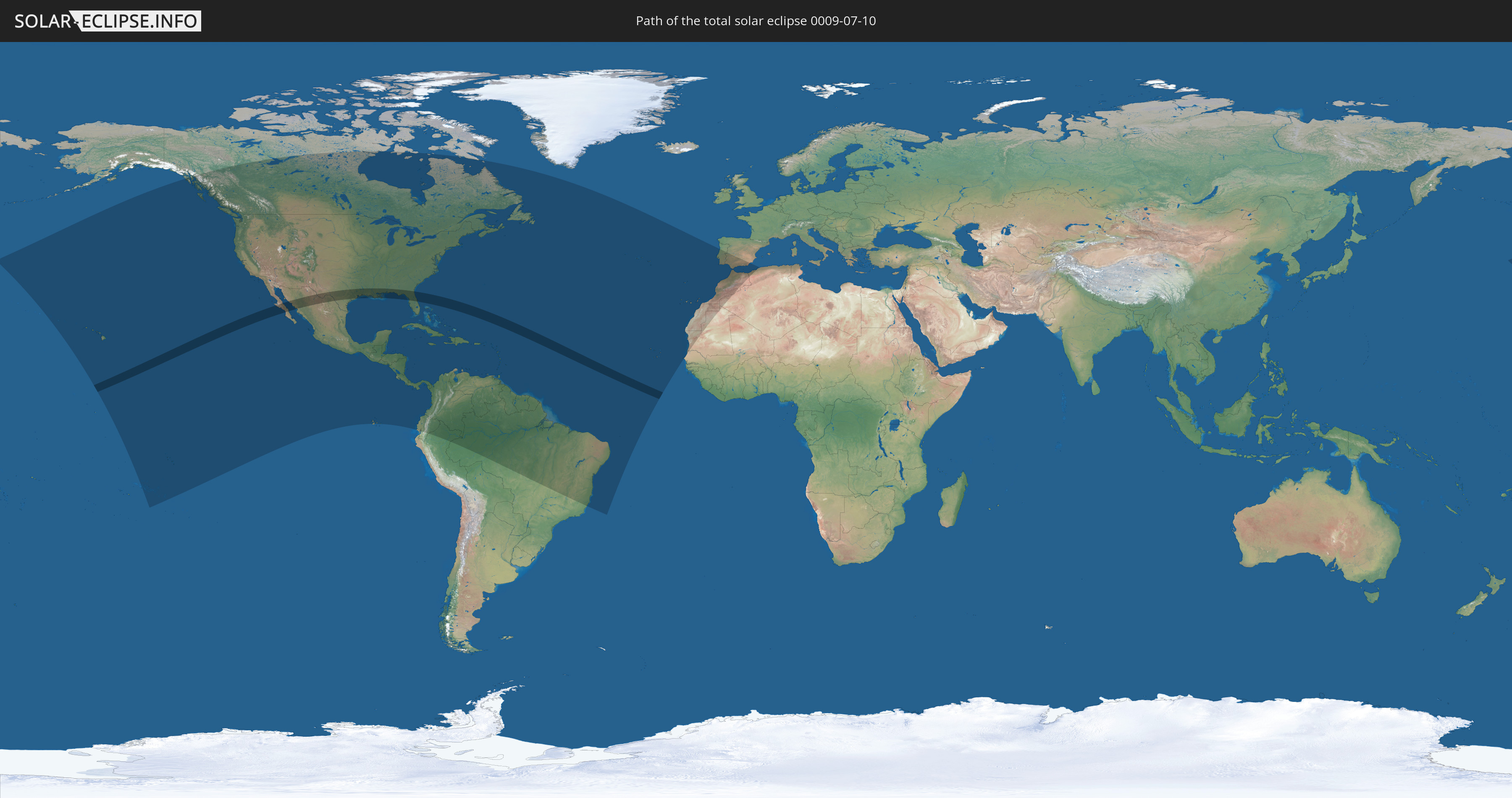
Die Sonnenfinsternis am 07/10/0009 kann man in 57 Ländern als partielle Sonnenfinsternis beobachten.
Der Finsternispfad verläuft durch 2 Länder. Nur in diesen Ländern ist sie als total Sonnenfinsternis zu sehen.
In den folgenden Ländern ist die Sonnenfinsternis total zu sehen
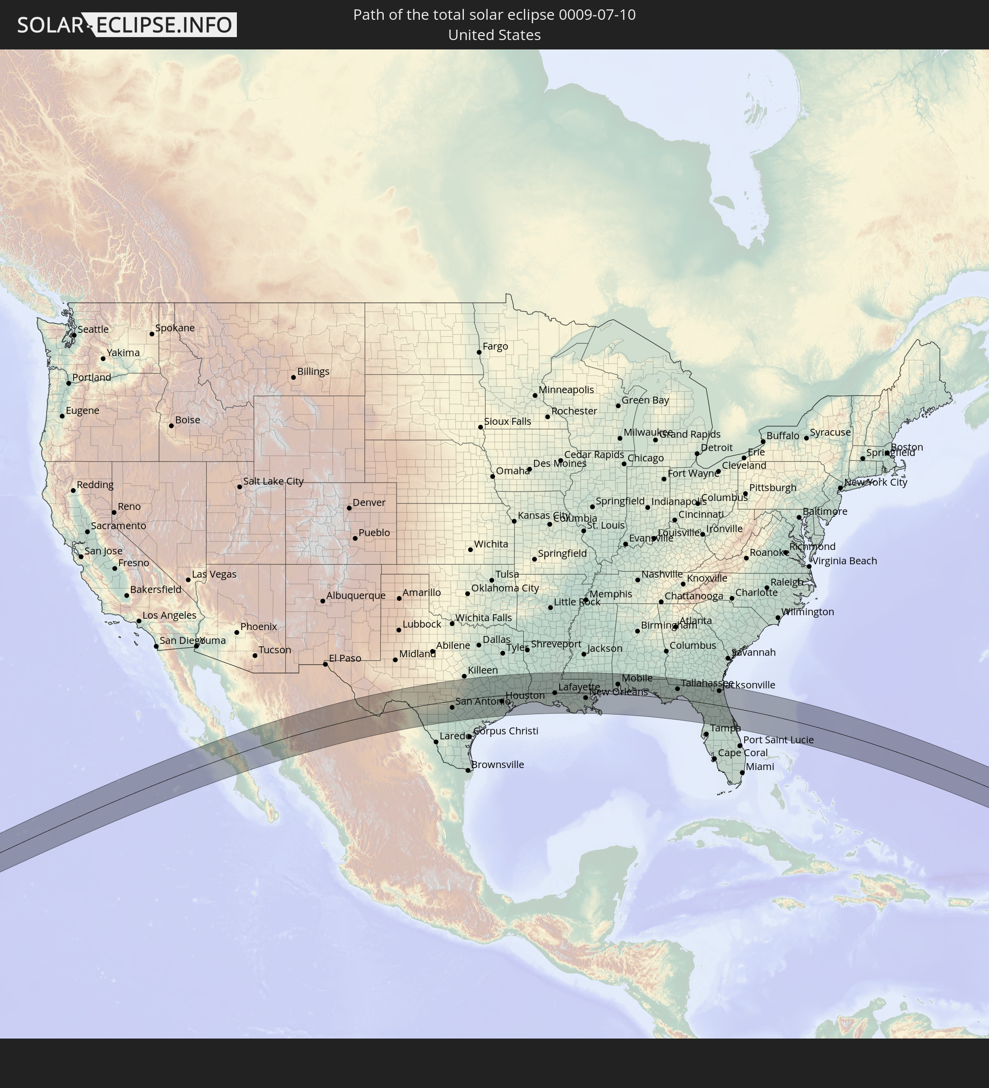 United States
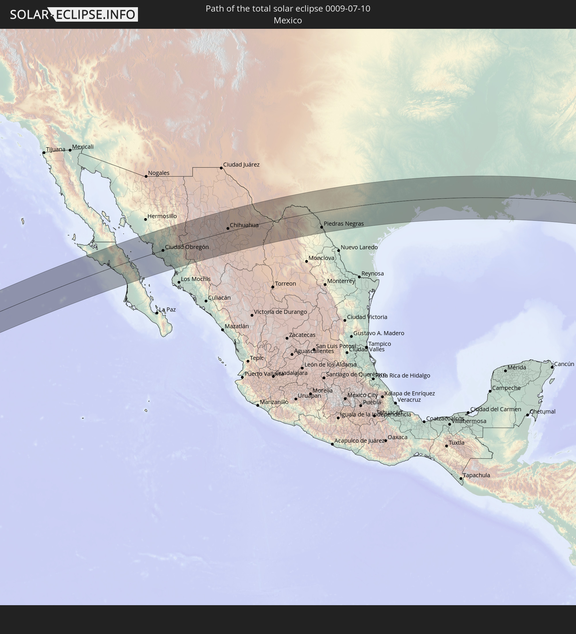 Mexico
In den folgenden Ländern ist die Sonnenfinsternis partiell zu sehen
 United States
 United States Minor Outlying Islands
 Kiribati
 French Polynesia
 Canada
 Mexico
 Greenland
 Guatemala
 Ecuador
 El Salvador
 Honduras
 Belize
 Nicaragua
 Costa Rica
 Cuba
Cuba
 Panama
 Colombia
 Cayman Islands
 Peru
Peru
 The Bahamas
 Jamaica
 Haiti
Haiti
 Brazil
 Venezuela
 Turks and Caicos Islands
 Dominican Republic
 Aruba
Aruba
 Puerto Rico
 United States Virgin Islands
 Bermuda
 British Virgin Islands
 Anguilla
 Collectivity of Saint Martin
 Saint Barthélemy
 Saint Kitts and Nevis
 Antigua and Barbuda
 Montserrat
 Trinidad and Tobago
 Guadeloupe
 Grenada
 Dominica
 Saint Vincent and the Grenadines
 Guyana
 Martinique
 Saint Lucia
 Barbados
 Suriname
 Saint Pierre and Miquelon
 French Guiana
 Portugal
 Cabo Verde
 Spain
Spain
 Senegal
 Mauritania
 Morocco
 Algeria
 Gibraltar
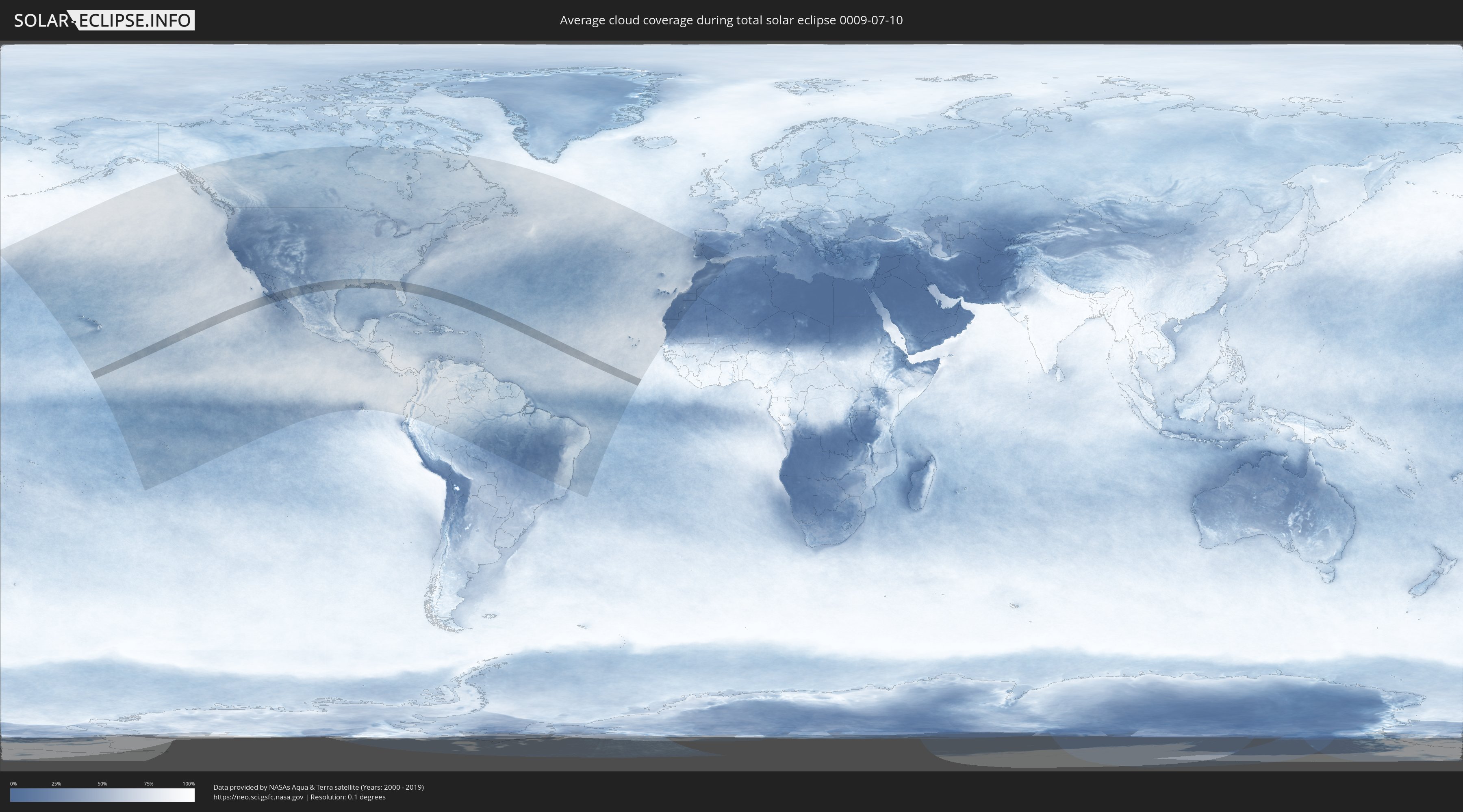
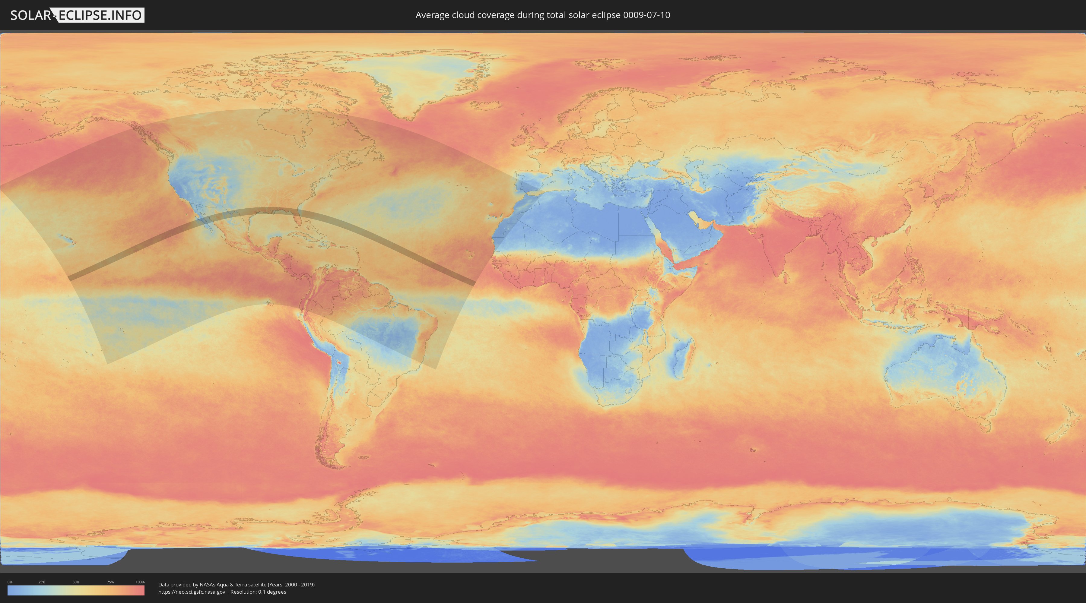
How will be the weather during the total solar eclipse on 07/10/0009?
Where is the best place to see the total solar eclipse of 07/10/0009?
The following maps show the average cloud coverage for the day of the total solar eclipse.
With the help of these maps, it is possible to find the place along the eclipse path, which has the best
chance of a cloudless sky.
Nevertheless, you should consider local circumstances and inform about the weather of your chosen
observation site.
The data is provided by NASAs satellites
AQUA and TERRA.
The cloud maps are averaged over a period of 19 years (2000 - 2019).
Detailed country maps
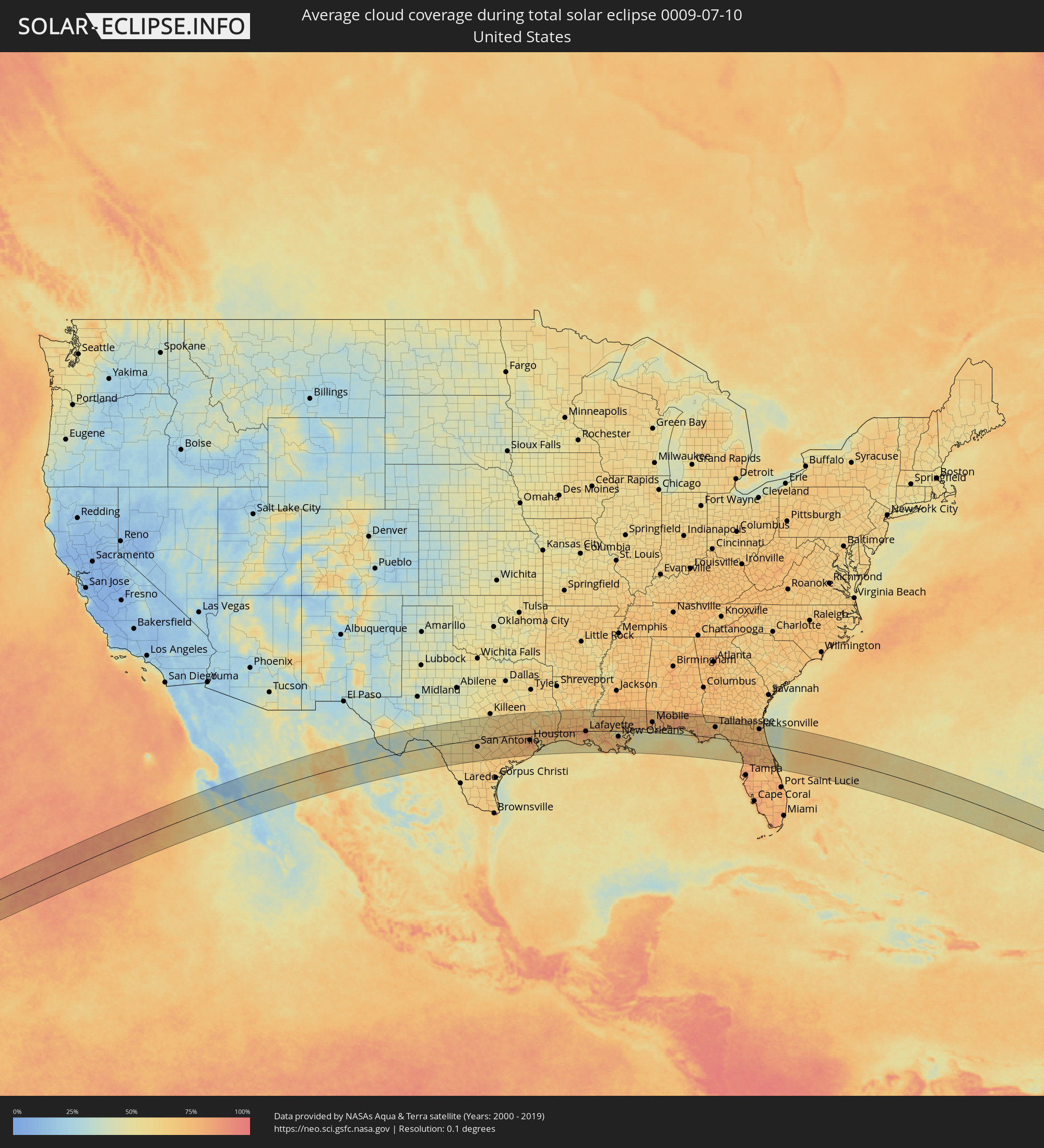 United States
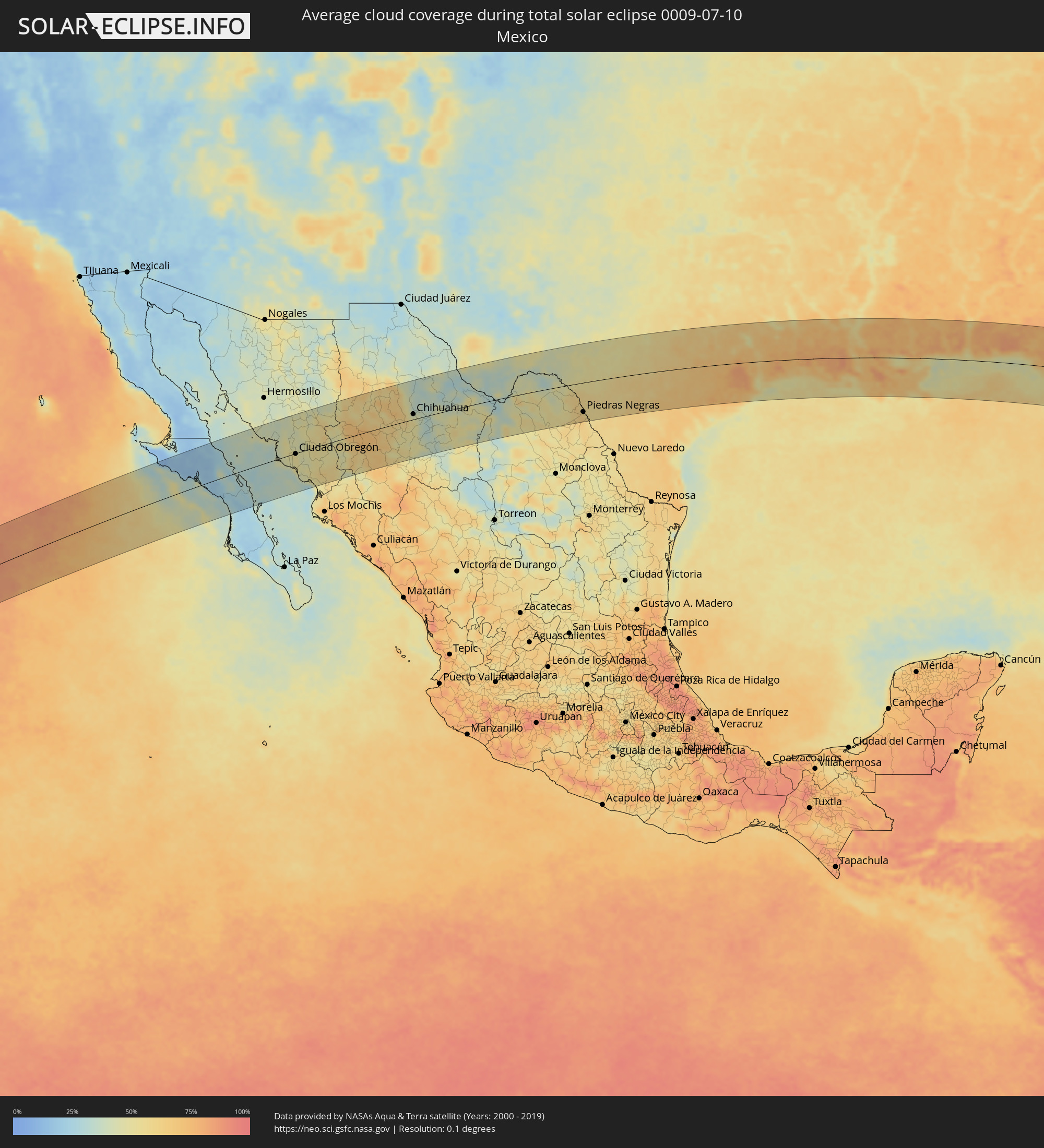 Mexico
Cities inside the path of the eclipse
The following table shows all locations with a population of more than 5,000 inside the eclipse path. Cities which have more than 100,000 inhabitants are marked bold. A click at the locations opens a detailed map.
| City | Type | Eclipse duration | Local time of max. eclipse | Distance to central line | Ø Cloud coverage |
|
Santa Rosalia, Baja California Sur
|
total | - | 09:59:13 UTC-07:05 | 55 km | 28% |
|
Loreto, Baja California Sur
|
total | - | 09:59:38 UTC-07:05 | 114 km | 34% |
|
Heroica Guaymas, Sonora
|
total | - | 09:44:06 UTC-07:23 | 73 km | 42% |
|
Empalme, Sonora
|
total | - | 09:44:18 UTC-07:23 | 75 km | 46% |
|
Potam, Sonora
|
total | - | 09:44:45 UTC-07:23 | 27 km | 46% |
|
Vicam, Sonora
|
total | - | 09:45:00 UTC-07:23 | 26 km | 50% |
|
San Ignacio Río Muerto, Sonora
|
total | - | 09:44:52 UTC-07:23 | 0 km | 47% |
|
Campo Sesenta, Sonora
|
total | - | 09:45:11 UTC-07:23 | 1 km | 50% |
|
Pueblo Yaqui, Sonora
|
total | - | 09:45:14 UTC-07:23 | 13 km | 52% |
|
Cocorit, Sonora
|
total | - | 09:45:35 UTC-07:23 | 8 km | 49% |
|
Ciudad Obregón, Sonora
|
total | - | 09:45:32 UTC-07:23 | 2 km | 48% |
|
El Tobarito, Sonora
|
total | - | 09:45:31 UTC-07:23 | 15 km | 52% |
|
Marte R. Gómez (Tobarito), Sonora
|
total | - | 09:45:32 UTC-07:23 | 16 km | 52% |
|
Villa Juarez, Sonora
|
total | - | 09:45:24 UTC-07:23 | 43 km | 46% |
|
Bacobampo, Sonora
|
total | - | 09:45:38 UTC-07:23 | 64 km | 46% |
|
Huatabampo, Sonora
|
total | - | 09:45:30 UTC-07:23 | 81 km | 46% |
|
Etchojoa, Sonora
|
total | - | 09:45:37 UTC-07:23 | 72 km | 46% |
|
La Unión, Sonora
|
total | - | 09:45:34 UTC-07:23 | 82 km | 46% |
|
Navojoa, Sonora
|
total | - | 09:46:07 UTC-07:23 | 61 km | 51% |
|
Alamos, Sonora
|
total | - | 09:47:06 UTC-07:23 | 80 km | 58% |
|
Creel, Chihuahua
|
total | - | 10:08:36 UTC-07:05 | 39 km | 70% |
|
Adolfo López Mateos, Chihuahua
|
total | - | 10:09:55 UTC-07:05 | 29 km | 57% |
|
Cuauhtémoc, Chihuahua
|
total | - | 10:10:46 UTC-07:05 | 11 km | 59% |
|
Anáhuac, Chihuahua
|
total | - | 10:11:05 UTC-07:05 | 16 km | 60% |
|
Valentín Gómez Farías, Chihuahua
|
total | - | 10:11:12 UTC-07:05 | 16 km | 55% |
|
Chihuahua, Chihuahua
|
total | - | 10:12:36 UTC-07:05 | 16 km | 48% |
|
Ampliación Colonia Lázaro Cárdenas, Chihuahua
|
total | - | 10:13:24 UTC-07:05 | 22 km | 33% |
|
Rosales, Chihuahua
|
total | - | 10:13:23 UTC-07:05 | 45 km | 32% |
|
Naica, Chihuahua
|
total | - | 10:13:16 UTC-07:05 | 82 km | 39% |
|
Pedro Meoqui, Chihuahua
|
total | - | 10:13:37 UTC-07:05 | 36 km | 37% |
|
Ciudad Delicias, Chihuahua
|
total | - | 10:13:34 UTC-07:05 | 47 km | 37% |
|
Jiménez, Chihuahua
|
total | - | 10:13:50 UTC-07:05 | 33 km | 42% |
|
Saucillo, Chihuahua
|
total | - | 10:13:50 UTC-07:05 | 68 km | 38% |
|
Ciudad Camargo, Chihuahua
|
total | - | 10:13:50 UTC-07:05 | 109 km | 39% |
|
Ojinaga, Chihuahua
|
total | - | 10:16:39 UTC-07:05 | 81 km | 34% |
|
Manuel Ojinaga, Chihuahua
|
total | - | 10:16:55 UTC-07:05 | 78 km | 35% |
|
Ciudad Acuña, Coahuila
|
total | - | 10:53:40 UTC-06:36 | 16 km | 57% |
|
Zaragoza, Coahuila
|
total | - | 10:53:15 UTC-06:36 | 108 km | 61% |
|
Del Rio, Texas
|
total | - | 11:30:25 UTC-06:00 | 13 km | 54% |
|
Nava, Coahuila
|
total | - | 10:53:35 UTC-06:36 | 118 km | 62% |
|
Piedras Negras, Coahuila
|
total | - | 10:54:20 UTC-06:36 | 92 km | 59% |
|
Eagle Pass, Texas
|
total | - | 11:30:59 UTC-06:00 | 91 km | 59% |
|
Uvalde, Texas
|
total | - | 11:32:58 UTC-06:00 | 47 km | 57% |
|
Kerrville, Texas
|
total | - | 11:34:57 UTC-06:00 | 35 km | 54% |
|
San Antonio, Texas
|
total | - | 11:36:13 UTC-06:00 | 42 km | 59% |
|
Timberwood Park, Texas
|
total | - | 11:36:23 UTC-06:00 | 11 km | 59% |
|
Schertz, Texas
|
total | - | 11:36:49 UTC-06:00 | 31 km | 62% |
|
Canyon Lake, Texas
|
total | - | 11:36:59 UTC-06:00 | 5 km | 56% |
|
New Braunfels, Texas
|
total | - | 11:37:14 UTC-06:00 | 16 km | 62% |
|
Seguin, Texas
|
total | - | 11:37:34 UTC-06:00 | 33 km | 64% |
|
San Marcos, Texas
|
total | - | 11:37:45 UTC-06:00 | 2 km | 62% |
|
Leander, Texas
|
total | - | 11:38:16 UTC-06:00 | 77 km | 58% |
|
Austin, Texas
|
total | - | 11:38:24 UTC-06:00 | 42 km | 59% |
|
Round Rock, Texas
|
total | - | 11:38:39 UTC-06:00 | 68 km | 60% |
|
Taylor, Texas
|
total | - | 11:39:20 UTC-06:00 | 72 km | 66% |
|
Brenham, Texas
|
total | - | 11:41:39 UTC-06:00 | 16 km | 70% |
|
College Station, Texas
|
total | - | 11:41:57 UTC-06:00 | 67 km | 69% |
|
Bay City, Texas
|
total | - | 11:42:19 UTC-06:00 | 119 km | 74% |
|
Rosenberg, Texas
|
total | - | 11:42:55 UTC-06:00 | 56 km | 76% |
|
Cinco Ranch, Texas
|
total | - | 11:43:06 UTC-06:00 | 37 km | 75% |
|
Cypress, Texas
|
total | - | 11:43:19 UTC-06:00 | 12 km | 79% |
|
Sugar Land, Texas
|
total | - | 11:43:22 UTC-06:00 | 51 km | 79% |
|
Huntsville, Texas
|
total | - | 11:43:54 UTC-06:00 | 71 km | 63% |
|
The Woodlands, Texas
|
total | - | 11:43:53 UTC-06:00 | 8 km | 78% |
|
Conroe, Texas
|
total | - | 11:44:01 UTC-06:00 | 24 km | 74% |
|
Fresno, Texas
|
total | - | 11:43:49 UTC-06:00 | 61 km | 77% |
|
Lake Jackson, Texas
|
total | - | 11:43:42 UTC-06:00 | 118 km | 68% |
|
Angleton, Texas
|
total | - | 11:43:45 UTC-06:00 | 103 km | 71% |
|
Aldine, Texas
|
total | - | 11:44:06 UTC-06:00 | 18 km | 82% |
|
Houston, Texas
|
total | - | 11:44:05 UTC-06:00 | 37 km | 81% |
|
Pearland, Texas
|
total | - | 11:44:14 UTC-06:00 | 60 km | 79% |
|
Alvin, Texas
|
total | - | 11:44:18 UTC-06:00 | 76 km | 73% |
|
Pasadena, Texas
|
total | - | 11:44:27 UTC-06:00 | 46 km | 81% |
|
Atascocita, Texas
|
total | - | 11:44:37 UTC-06:00 | 12 km | 75% |
|
League City, Texas
|
total | - | 11:44:42 UTC-06:00 | 68 km | 77% |
|
Baytown, Texas
|
total | - | 11:45:03 UTC-06:00 | 43 km | 71% |
|
La Marque, Texas
|
total | - | 11:44:58 UTC-06:00 | 84 km | 70% |
|
Galveston, Texas
|
total | - | 11:45:24 UTC-06:00 | 93 km | 52% |
|
Beaumont, Texas
|
total | - | 11:47:20 UTC-06:00 | 10 km | 82% |
|
Port Arthur, Texas
|
total | - | 11:47:42 UTC-06:00 | 33 km | 69% |
|
Orange, Texas
|
total | - | 11:48:16 UTC-06:00 | 11 km | 70% |
|
Sulphur, Louisiana
|
total | - | 11:49:11 UTC-06:00 | 4 km | 76% |
|
Lake Charles, Louisiana
|
total | - | 11:49:37 UTC-06:00 | 1 km | 79% |
|
Alexandria, Louisiana
|
total | - | 11:51:39 UTC-06:00 | 120 km | 63% |
|
Crowley, Louisiana
|
total | - | 11:51:43 UTC-06:00 | 2 km | 79% |
|
Opelousas, Louisiana
|
total | - | 11:52:29 UTC-06:00 | 33 km | 81% |
|
Lafayette, Louisiana
|
total | - | 11:52:37 UTC-06:00 | 2 km | 84% |
|
New Iberia, Louisiana
|
total | - | 11:53:07 UTC-06:00 | 27 km | 81% |
|
Zachary, Louisiana
|
total | - | 11:54:49 UTC-06:00 | 45 km | 73% |
|
Baton Rouge, Louisiana
|
total | - | 11:54:49 UTC-06:00 | 23 km | 77% |
|
Central, Louisiana
|
total | - | 11:55:07 UTC-06:00 | 34 km | 79% |
|
Prairieville, Louisiana
|
total | - | 11:55:17 UTC-06:00 | 6 km | 76% |
|
Thibodaux, Louisiana
|
total | - | 11:55:39 UTC-06:00 | 50 km | 84% |
|
Houma, Louisiana
|
total | - | 11:55:55 UTC-06:00 | 73 km | 76% |
|
Laplace, Louisiana
|
total | - | 11:56:32 UTC-06:00 | 20 km | 73% |
|
Hammond, Louisiana
|
total | - | 11:56:34 UTC-06:00 | 29 km | 78% |
|
Kenner, Louisiana
|
total | - | 11:57:09 UTC-06:00 | 28 km | 80% |
|
New Orleans, Louisiana
|
total | - | 11:57:34 UTC-06:00 | 32 km | 82% |
|
Slidell, Louisiana
|
total | - | 11:58:18 UTC-06:00 | 4 km | 70% |
|
Carriere, Mississippi
|
total | - | 11:58:36 UTC-06:00 | 43 km | 72% |
|
Hattiesburg, Mississippi
|
total | - | 11:59:27 UTC-06:00 | 123 km | 75% |
|
West Gulfport, Mississippi
|
total | - | 12:00:02 UTC-06:00 | 20 km | 63% |
|
Biloxi, Mississippi
|
total | - | 12:00:34 UTC-06:00 | 20 km | 59% |
|
Pascagoula, Mississippi
|
total | - | 12:01:24 UTC-06:00 | 18 km | 64% |
|
Tillmans Corner, Alabama
|
total | - | 12:02:20 UTC-06:00 | 45 km | 79% |
|
Mobile, Alabama
|
total | - | 12:02:38 UTC-06:00 | 57 km | 70% |
|
Daphne, Alabama
|
total | - | 12:03:00 UTC-06:00 | 48 km | 62% |
|
Foley, Alabama
|
total | - | 12:03:36 UTC-06:00 | 27 km | 71% |
|
Cantonment, Florida
|
total | - | 12:04:25 UTC-06:00 | 52 km | 82% |
|
East Pensacola Heights, Florida
|
total | - | 12:04:52 UTC-06:00 | 33 km | 70% |
|
Pace, Florida
|
total | - | 12:04:52 UTC-06:00 | 52 km | 75% |
|
Navarre, Florida
|
total | - | 12:05:40 UTC-06:00 | 32 km | 61% |
|
Wright, Florida
|
total | - | 12:06:13 UTC-06:00 | 40 km | 73% |
|
Crestview, Florida
|
total | - | 12:06:18 UTC-06:00 | 74 km | 82% |
|
Panama City, Florida
|
total | - | 12:08:45 UTC-06:00 | 15 km | 69% |
|
Tallahassee, Florida
|
total | - | 13:12:04 UTC-05:00 | 61 km | 77% |
|
Thomasville, Georgia
|
total | - | 13:12:39 UTC-05:00 | 108 km | 72% |
|
Valdosta, Georgia
|
total | - | 13:14:21 UTC-05:00 | 117 km | 66% |
|
Homosassa Springs, Florida
|
total | - | 13:17:03 UTC-05:00 | 97 km | 77% |
|
Gainesville, Florida
|
total | - | 13:17:14 UTC-05:00 | 0 km | 76% |
|
Ocala, Florida
|
total | - | 13:17:56 UTC-05:00 | 48 km | 85% |
|
The Villages, Florida
|
total | - | 13:18:31 UTC-05:00 | 73 km | 78% |
|
Leesburg, Florida
|
total | - | 13:18:47 UTC-05:00 | 85 km | 75% |
|
Clermont, Florida
|
total | - | 13:19:11 UTC-05:00 | 112 km | 75% |
|
Lakeside, Florida
|
total | - | 13:18:20 UTC-05:00 | 61 km | 76% |
|
Eustis, Florida
|
total | - | 13:19:14 UTC-05:00 | 78 km | 70% |
|
Jacksonville, Florida
|
total | - | 13:18:30 UTC-05:00 | 85 km | 74% |
|
Lake Butler, Florida
|
total | - | 13:19:47 UTC-05:00 | 114 km | 78% |
|
Apopka, Florida
|
total | - | 13:19:46 UTC-05:00 | 94 km | 77% |
|
Ponte Vedra Beach, Florida
|
total | - | 13:19:12 UTC-05:00 | 79 km | 66% |
|
Orlando, Florida
|
total | - | 13:20:10 UTC-05:00 | 107 km | 81% |
|
Winter Springs, Florida
|
total | - | 13:20:15 UTC-05:00 | 88 km | 78% |
|
Deltona, Florida
|
total | - | 13:20:15 UTC-05:00 | 65 km | 75% |
|
Alafaya, Florida
|
total | - | 13:20:34 UTC-05:00 | 101 km | 82% |
|
Palm Coast, Florida
|
total | - | 13:20:00 UTC-05:00 | 11 km | 70% |
|
Daytona Beach, Florida
|
total | - | 13:20:39 UTC-05:00 | 27 km | 73% |
|
New Smyrna Beach, Florida
|
total | - | 13:21:00 UTC-05:00 | 46 km | 71% |
|
Titusville, Florida
|
total | - | 13:21:32 UTC-05:00 | 89 km | 72% |
|
Rockledge, Florida
|
total | - | 13:21:54 UTC-05:00 | 116 km | 73% |
|
Merritt Island, Florida
|
total | - | 13:21:55 UTC-05:00 | 95 km | 67% |