Total solar eclipse of 12/25/0056
| Day of week: | Monday |
| Maximum duration of eclipse: | 01m40s |
| Maximum width of eclipse path: | 73 km |
| Saros cycle: | 81 |
| Coverage: | 100% |
| Magnitude: | 1.0163 |
| Gamma: | 0.6386 |
Wo kann man die Sonnenfinsternis vom 12/25/0056 sehen?
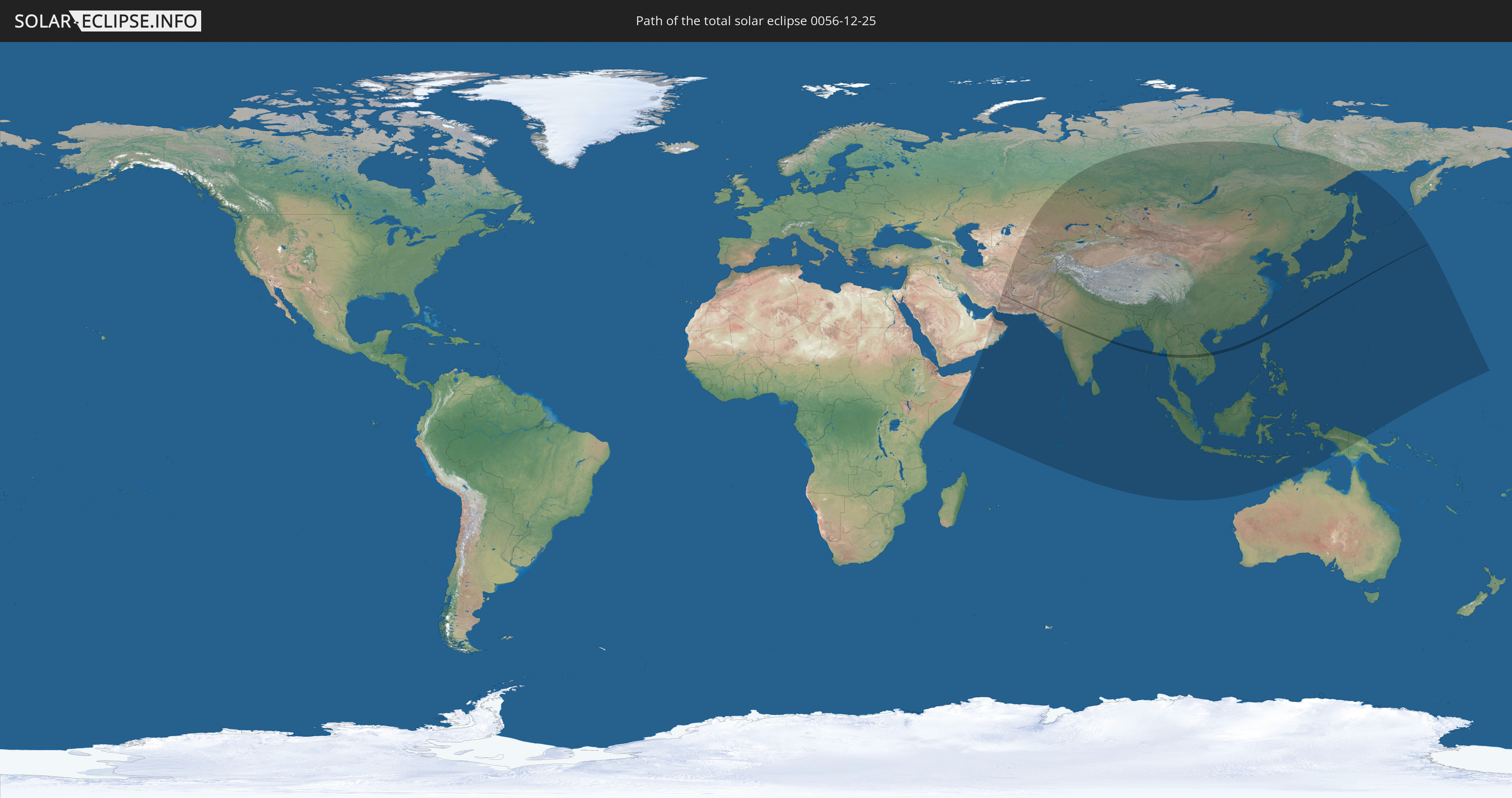
Die Sonnenfinsternis am 12/25/0056 kann man in 48 Ländern als partielle Sonnenfinsternis beobachten.
Der Finsternispfad verläuft durch 9 Länder. Nur in diesen Ländern ist sie als total Sonnenfinsternis zu sehen.
In den folgenden Ländern ist die Sonnenfinsternis total zu sehen
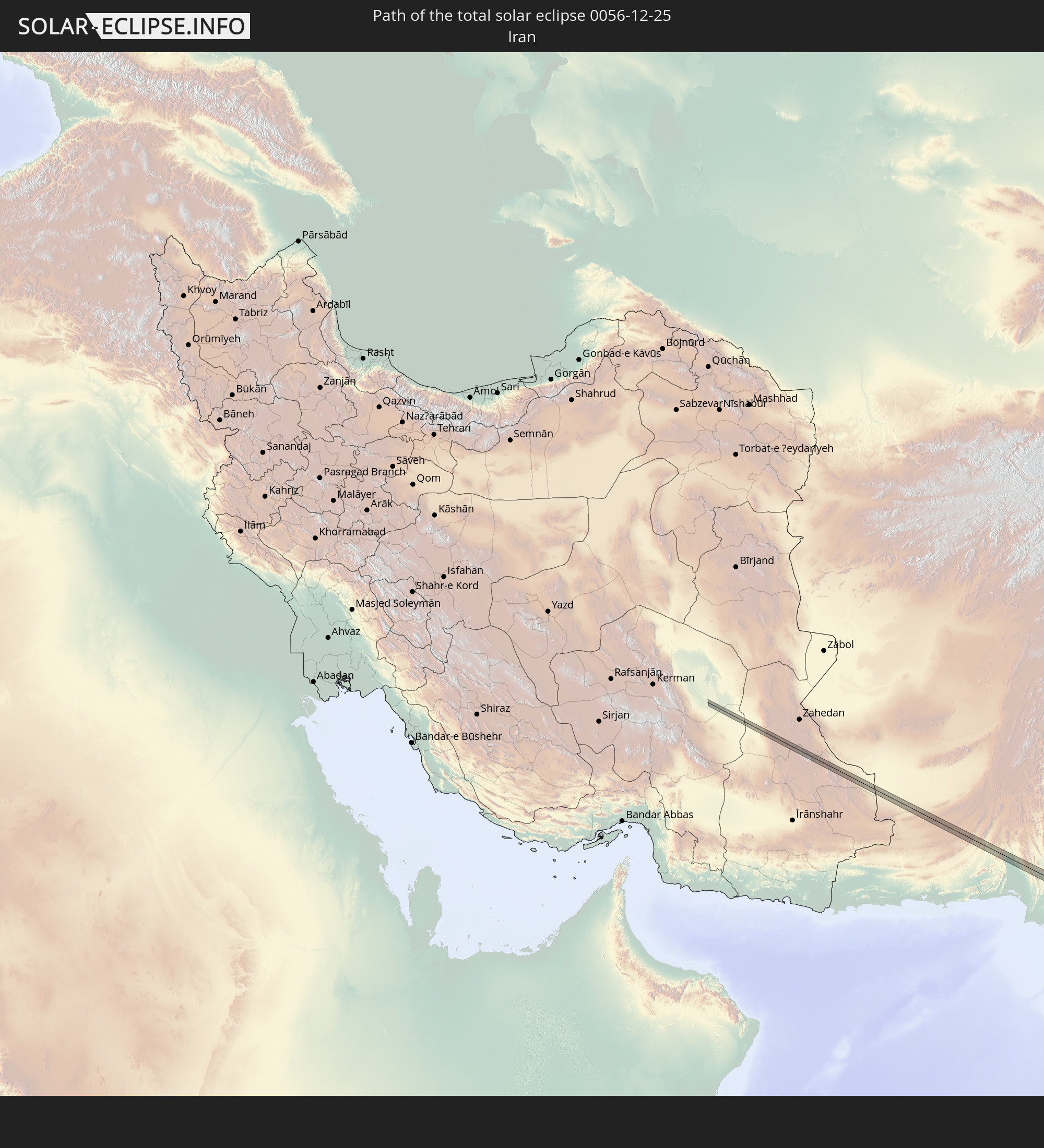 Iran
Iran
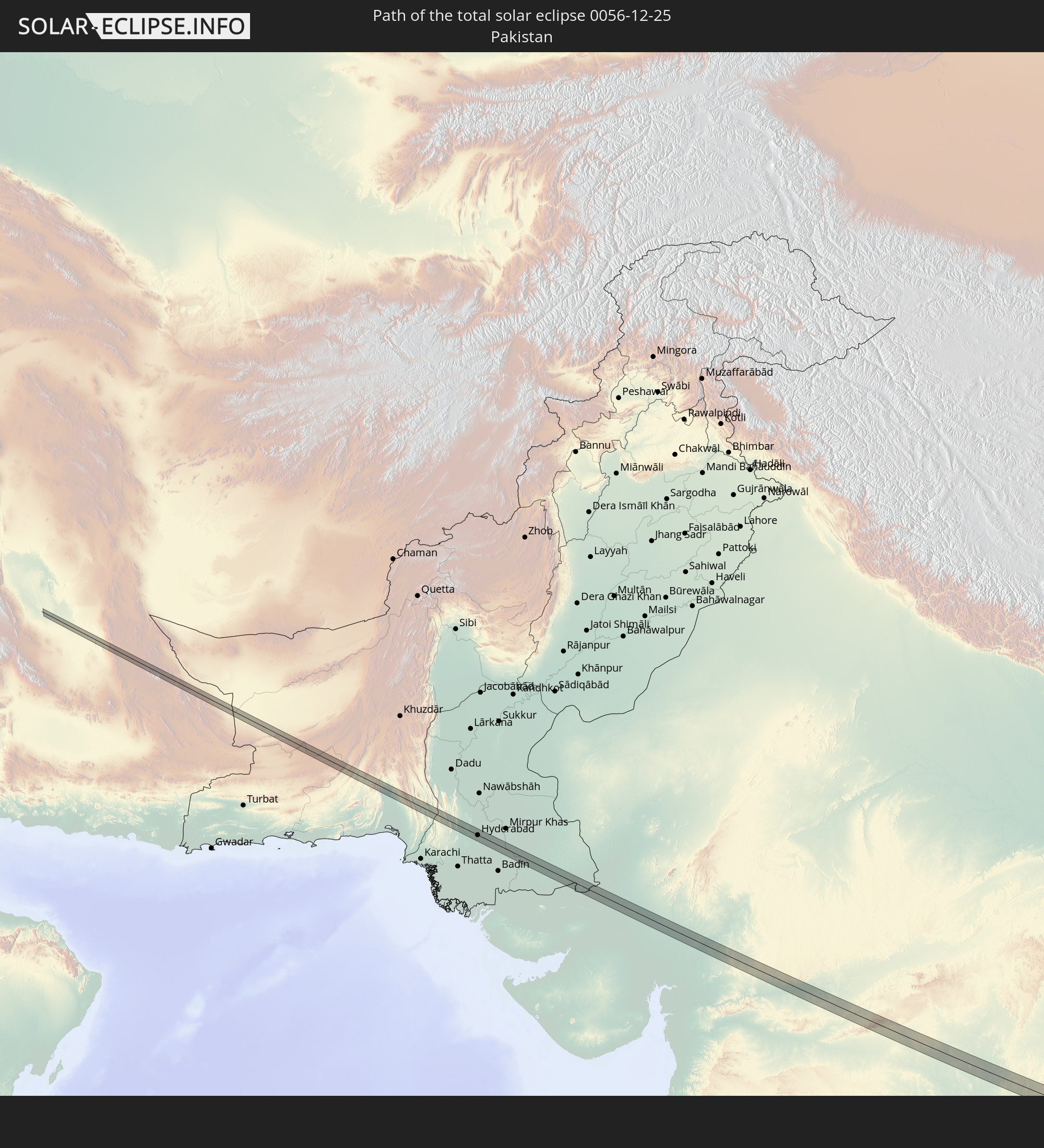 Pakistan
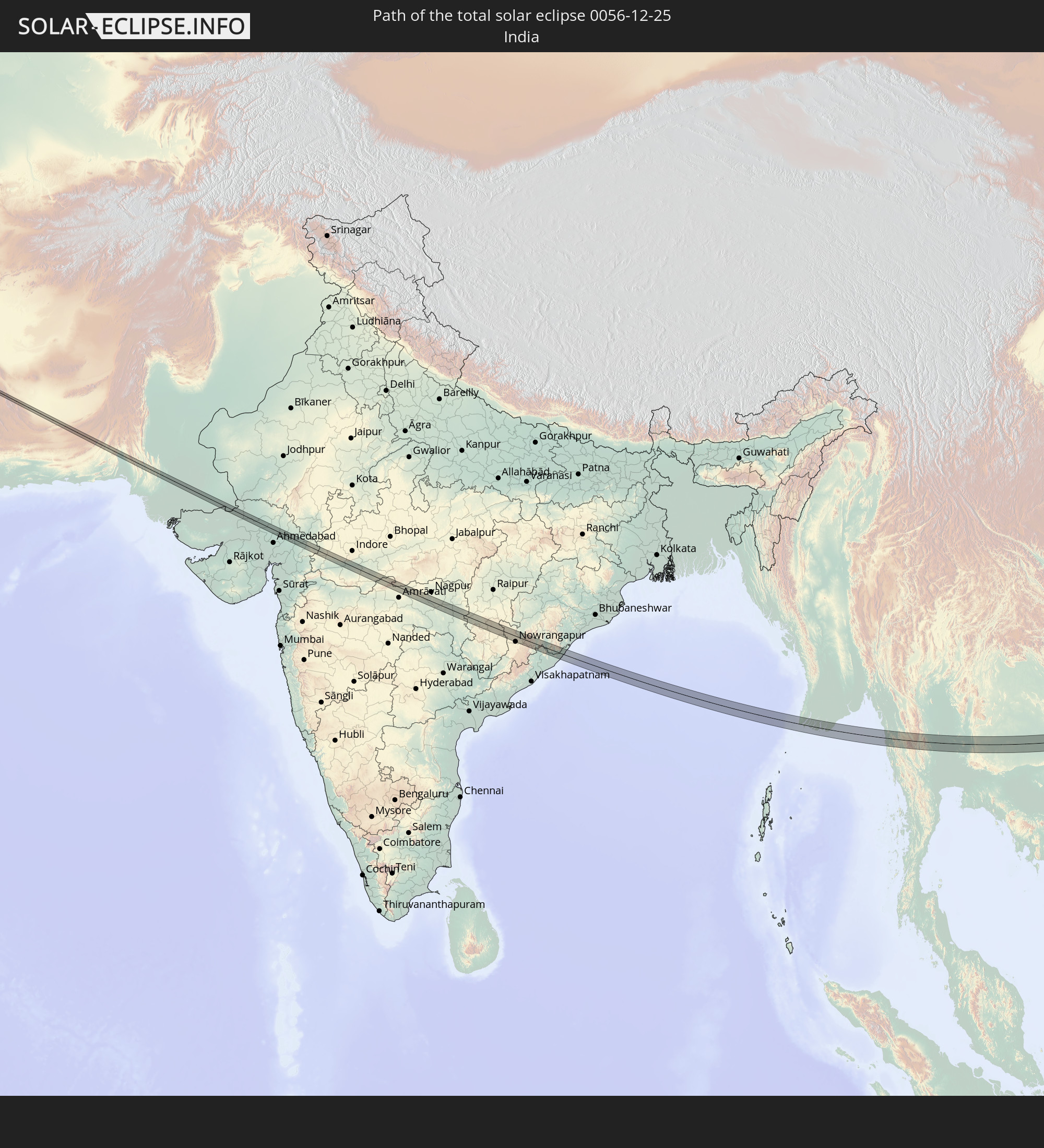 India
India
 Myanmar
 Thailand
 Laos
Laos
 Vietnam
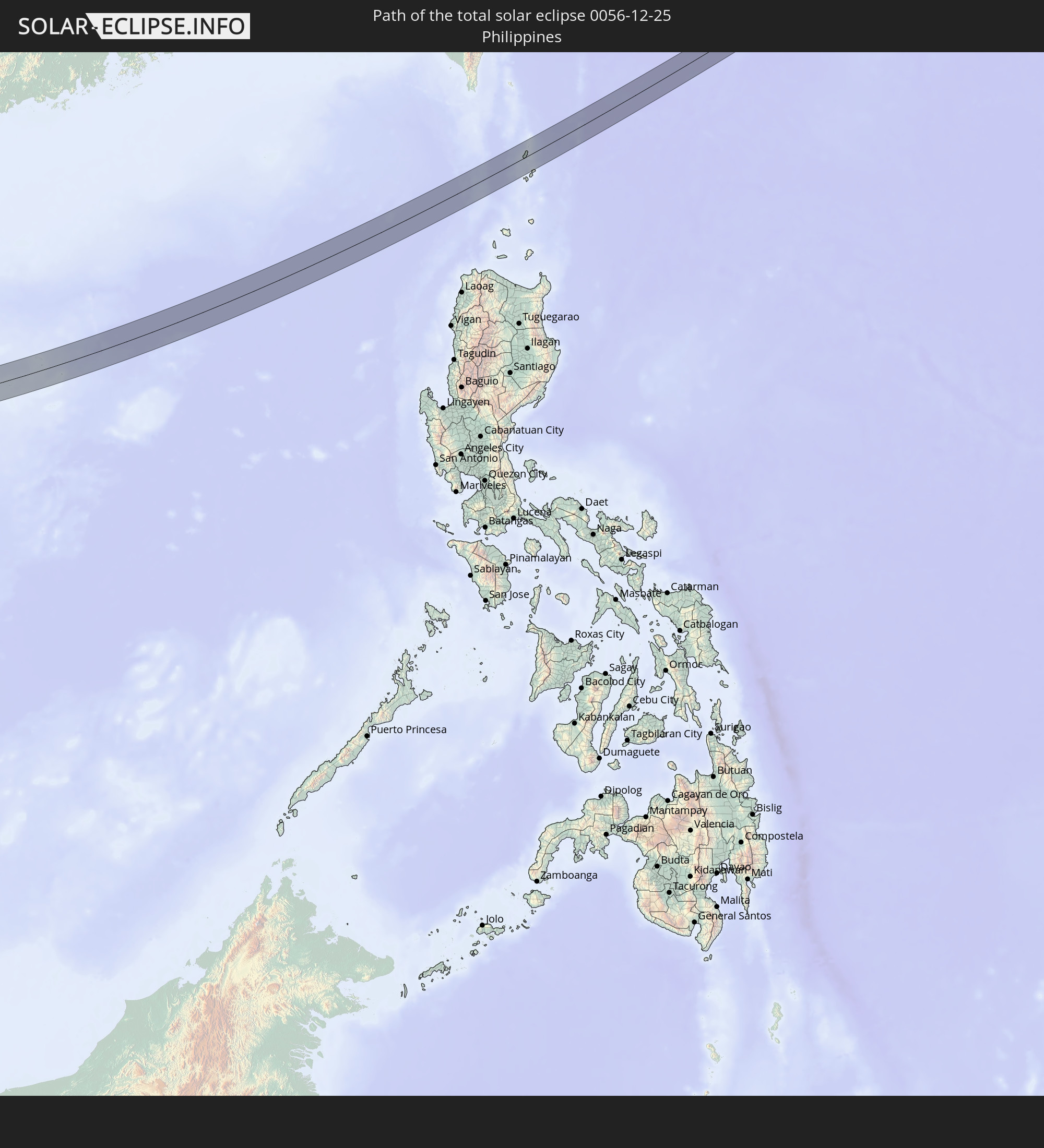 Philippines
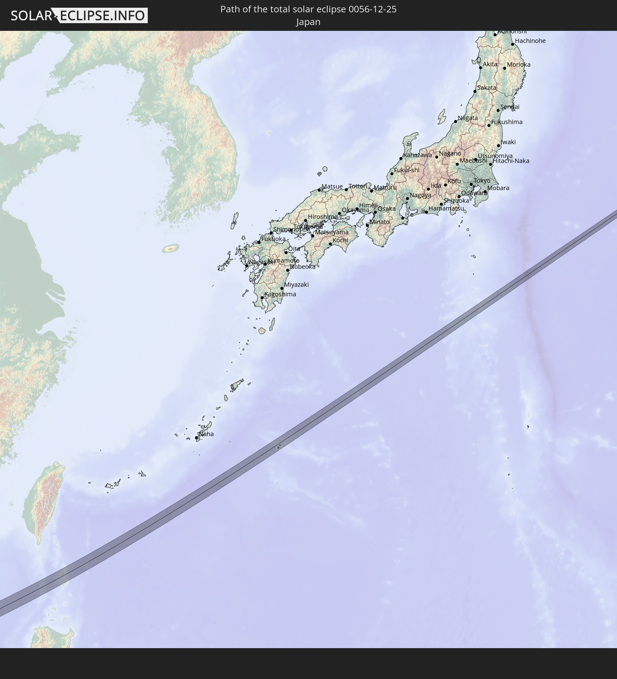 Japan
Japan
In den folgenden Ländern ist die Sonnenfinsternis partiell zu sehen
 Russia
 United States Minor Outlying Islands
 Yemen
Yemen
 Iran
Iran
 Seychelles
 Kazakhstan
 Oman
Oman
 Turkmenistan
 Uzbekistan
 Afghanistan
 Pakistan
 Tajikistan
 India
India
 Kyrgyzstan
 British Indian Ocean Territory
 Maldives
 China
China
 Sri Lanka
 Nepal
Nepal
 Mongolia
 Bangladesh
 Bhutan
 Myanmar
 Indonesia
 Cocos Islands
 Thailand
 Malaysia
 Laos
Laos
 Vietnam
 Cambodia
 Singapore
 Christmas Island
 Australia
 Macau
Macau
 Hong Kong
 Brunei
 Taiwan
 Philippines
 Japan
Japan
 East Timor
 North Korea
 South Korea
 Palau
Palau
 Federated States of Micronesia
 Papua New Guinea
 Guam
Guam
 Northern Mariana Islands
 Marshall Islands
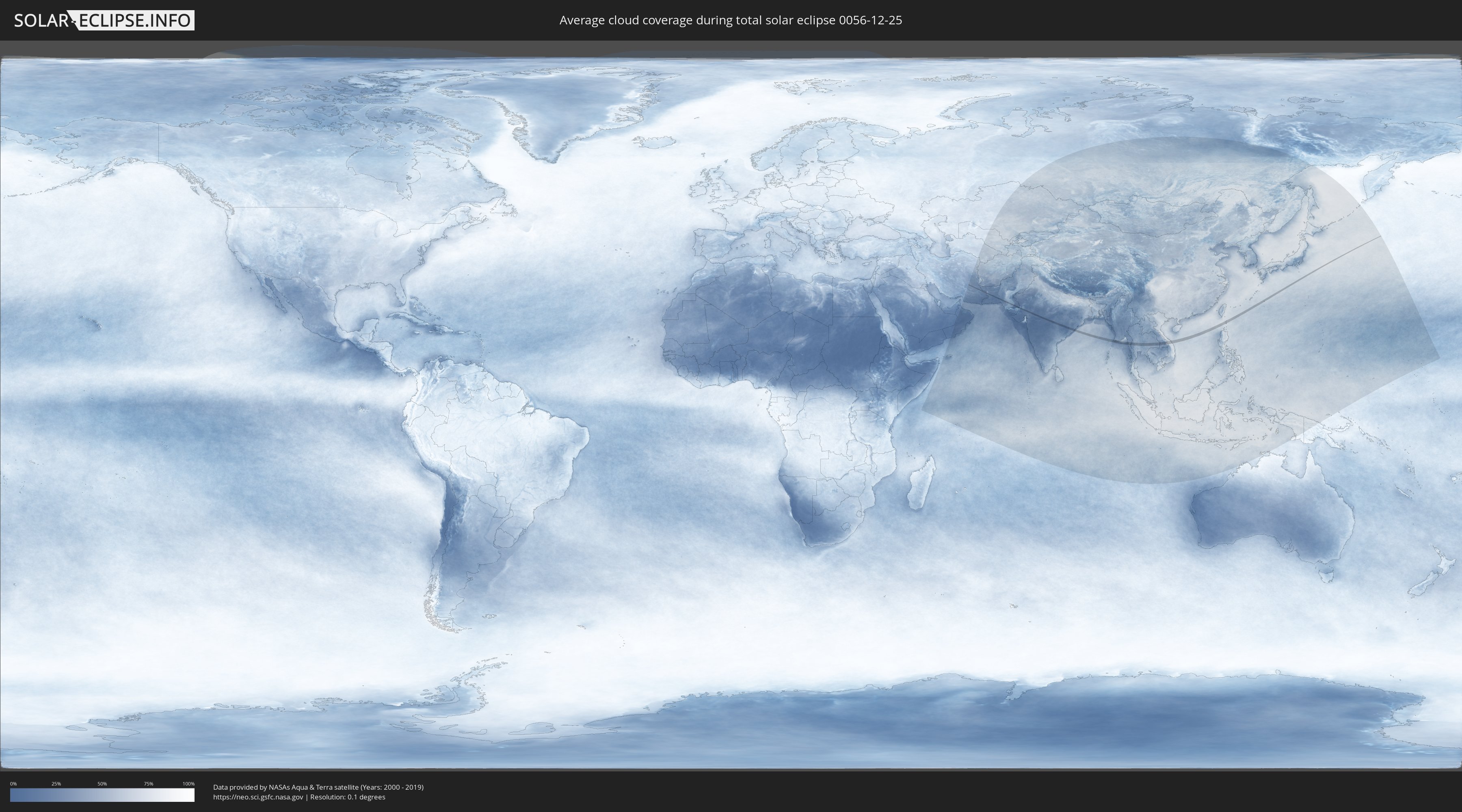
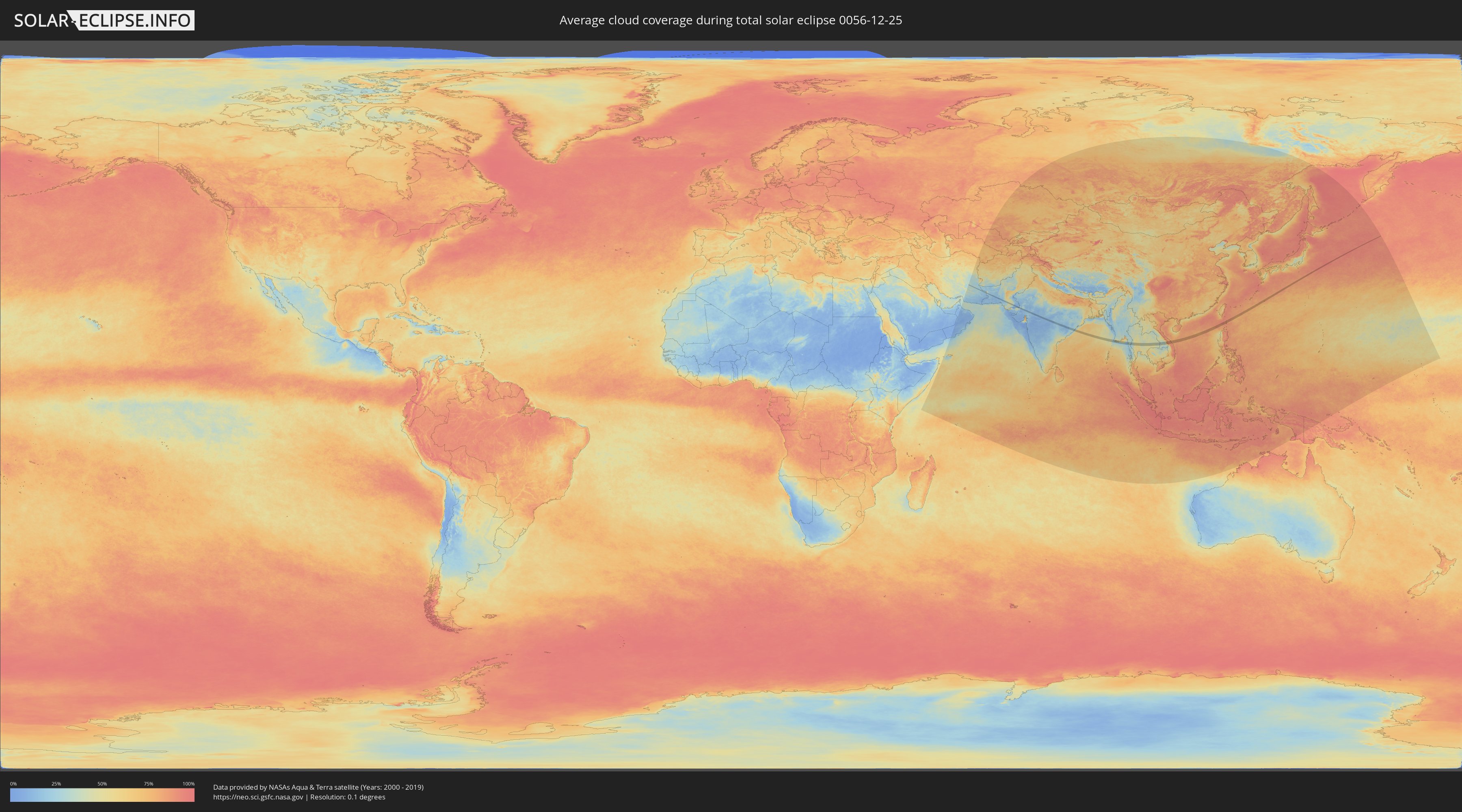
How will be the weather during the total solar eclipse on 12/25/0056?
Where is the best place to see the total solar eclipse of 12/25/0056?
The following maps show the average cloud coverage for the day of the total solar eclipse.
With the help of these maps, it is possible to find the place along the eclipse path, which has the best
chance of a cloudless sky.
Nevertheless, you should consider local circumstances and inform about the weather of your chosen
observation site.
The data is provided by NASAs satellites
AQUA and TERRA.
The cloud maps are averaged over a period of 19 years (2000 - 2019).
Detailed country maps
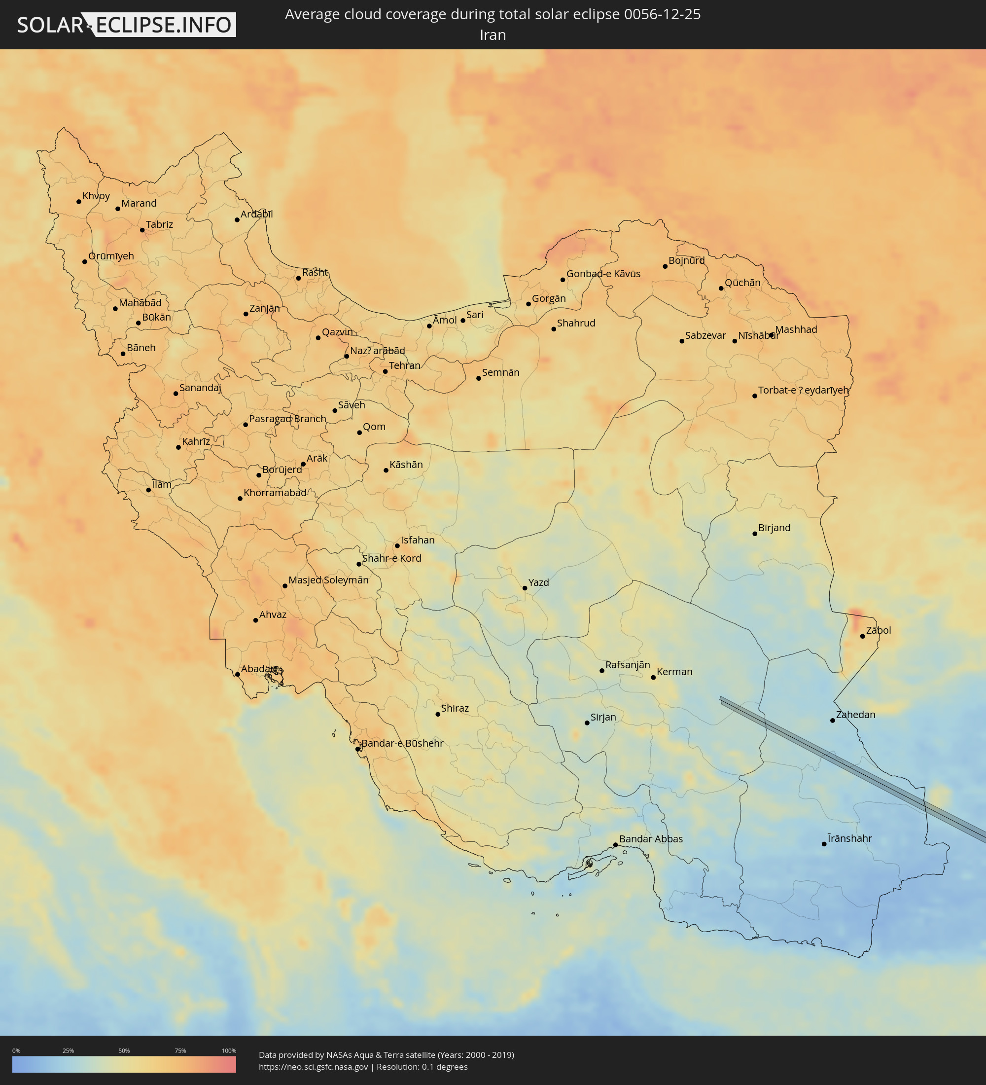 Iran
Iran
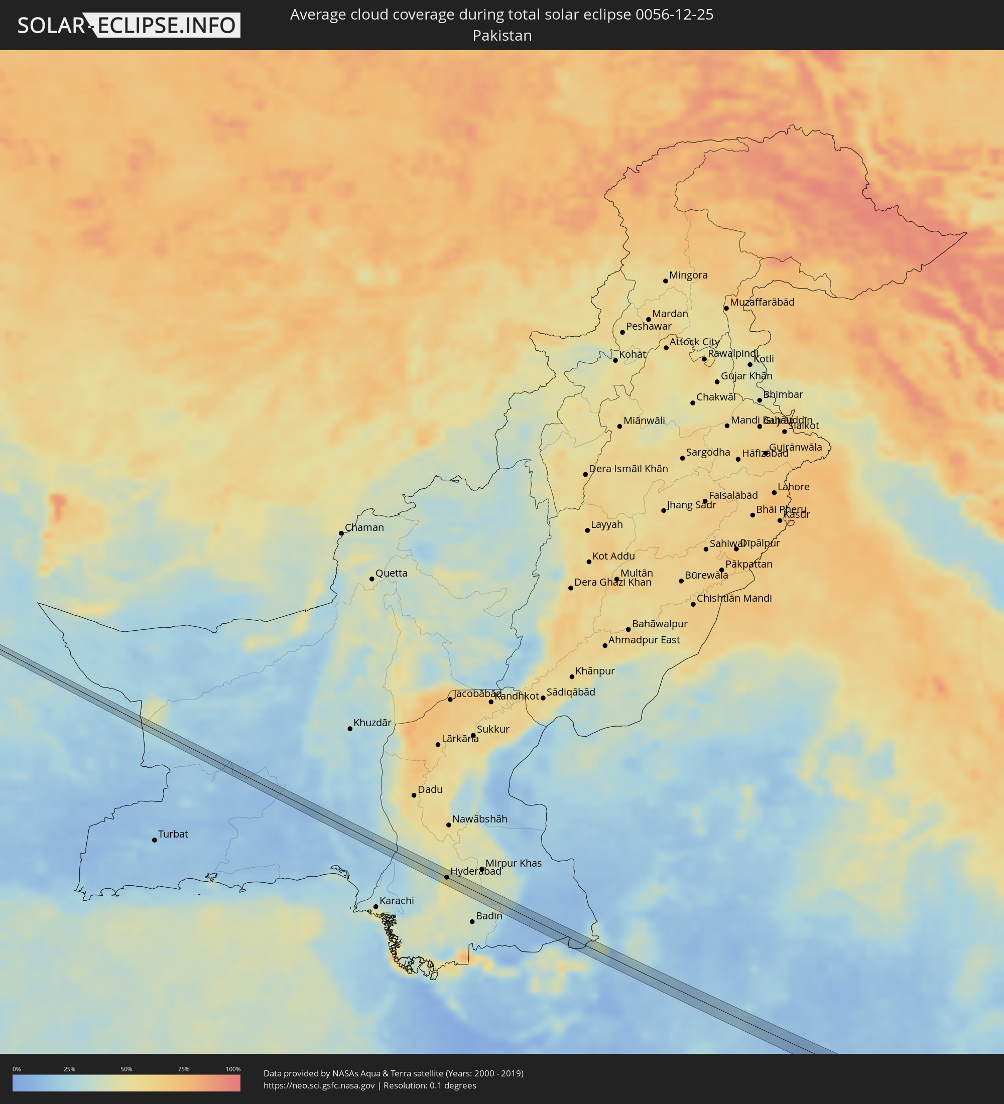 Pakistan
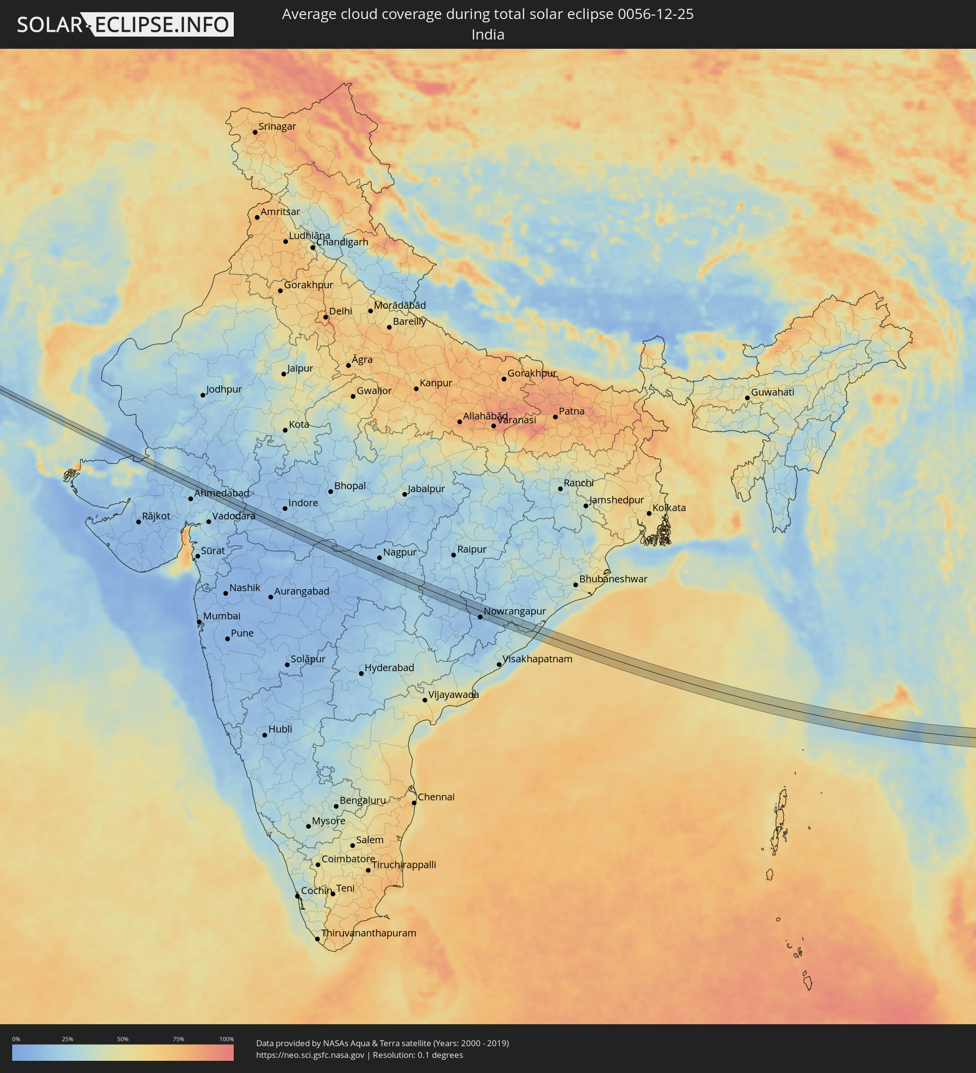 India
India
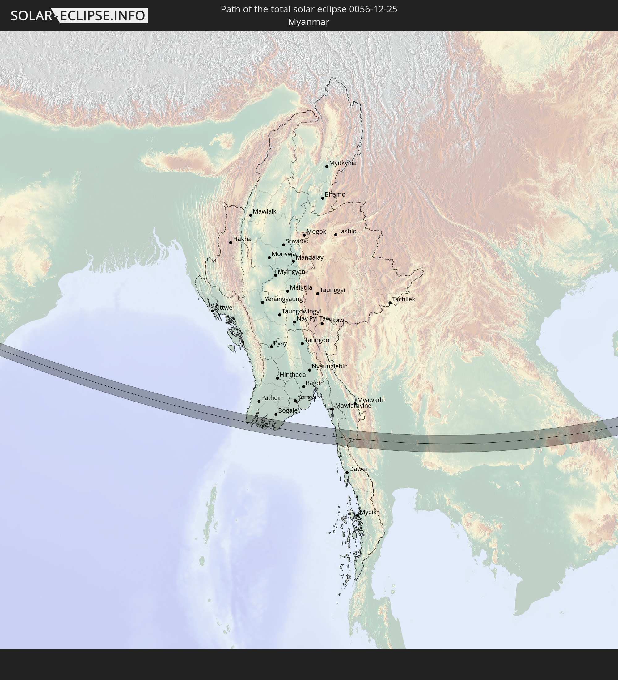
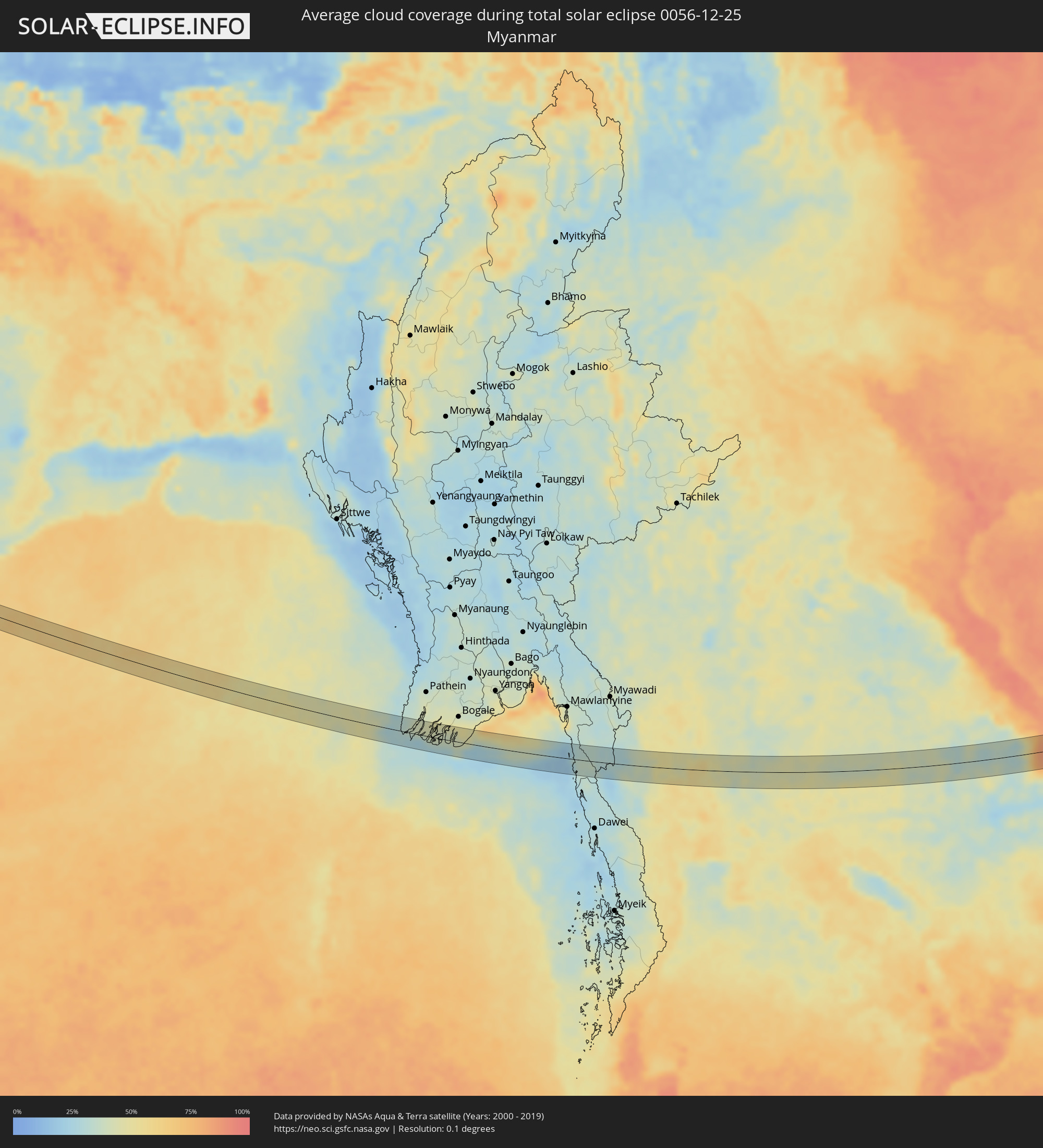 Myanmar
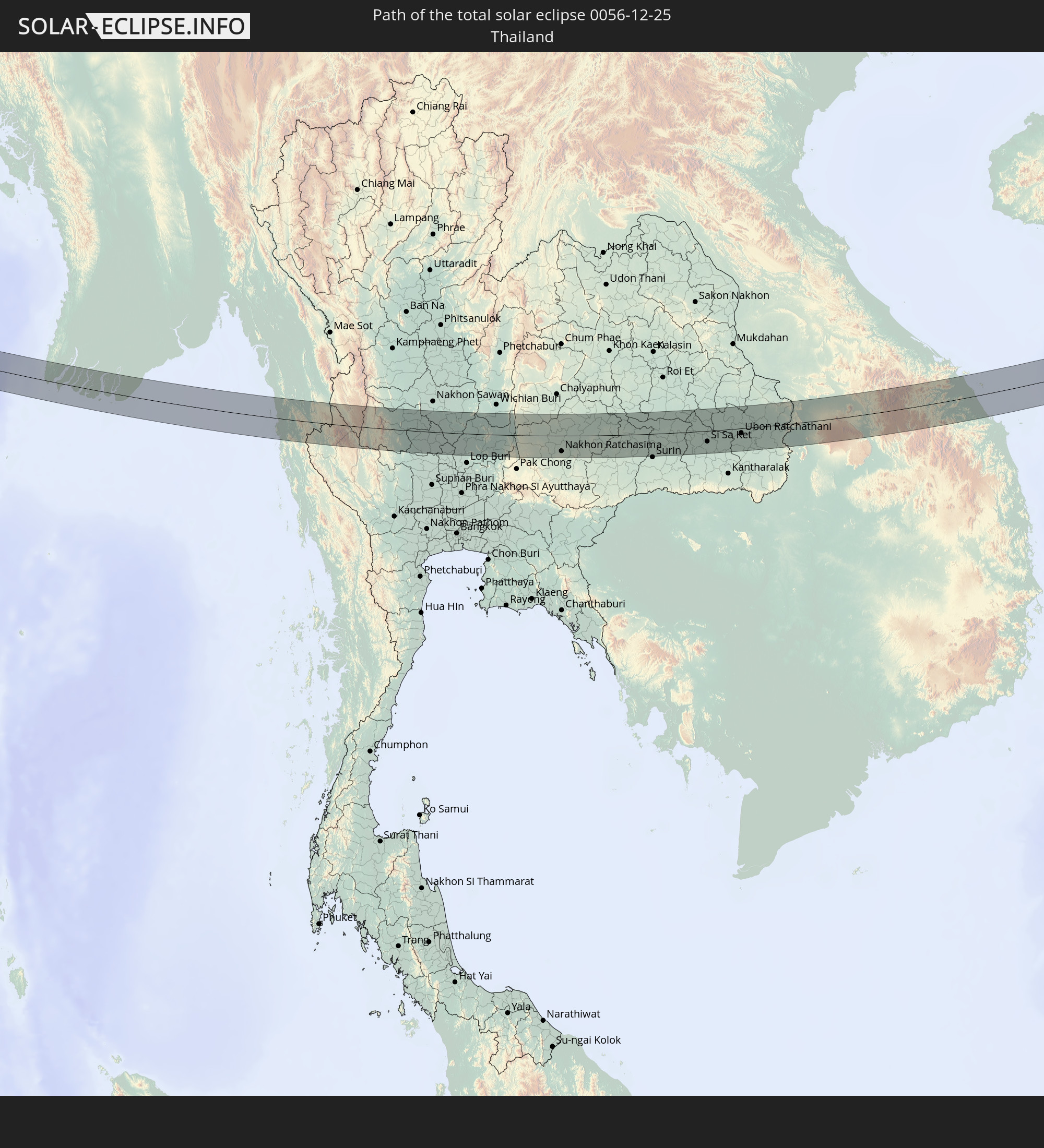
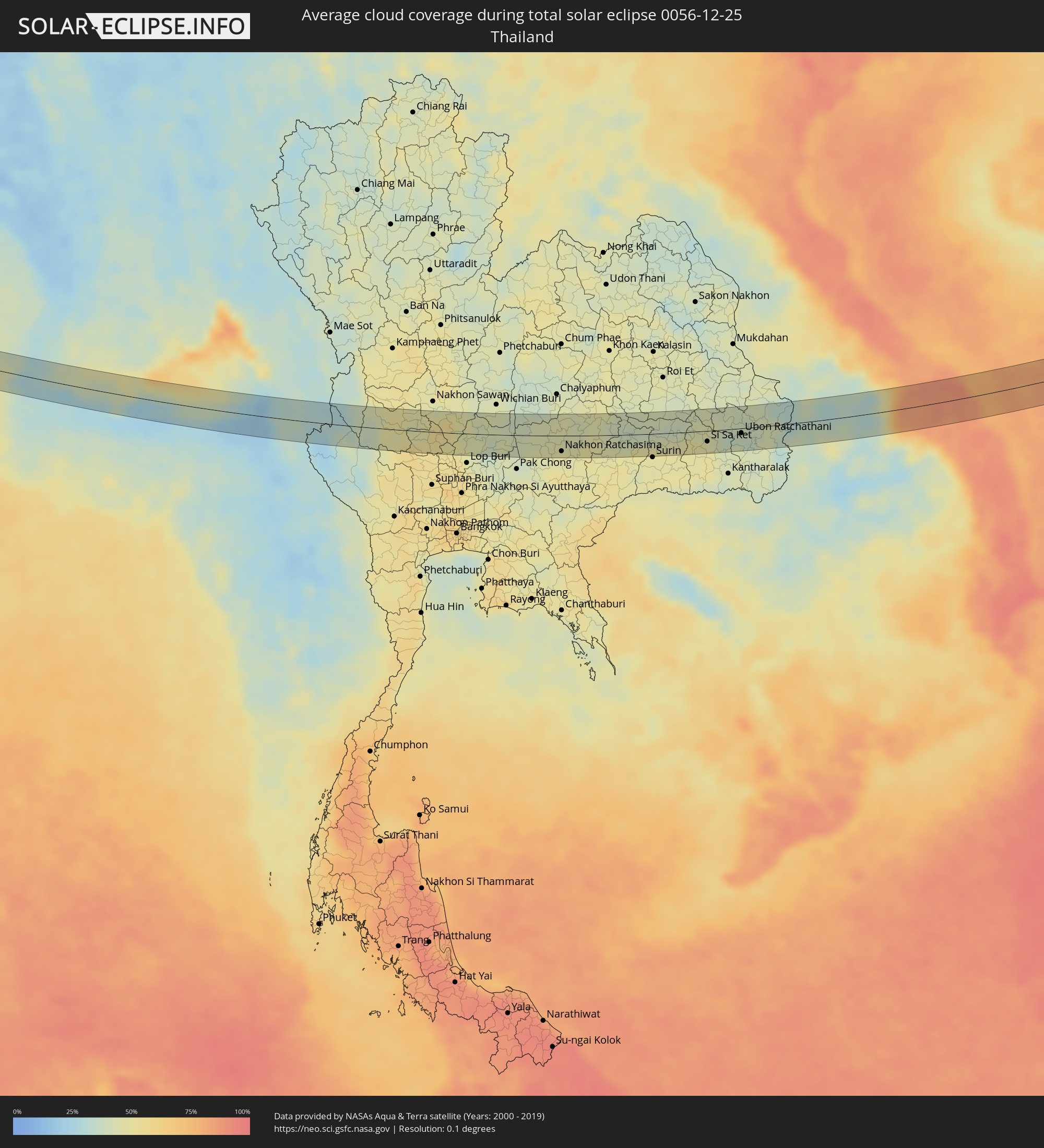 Thailand
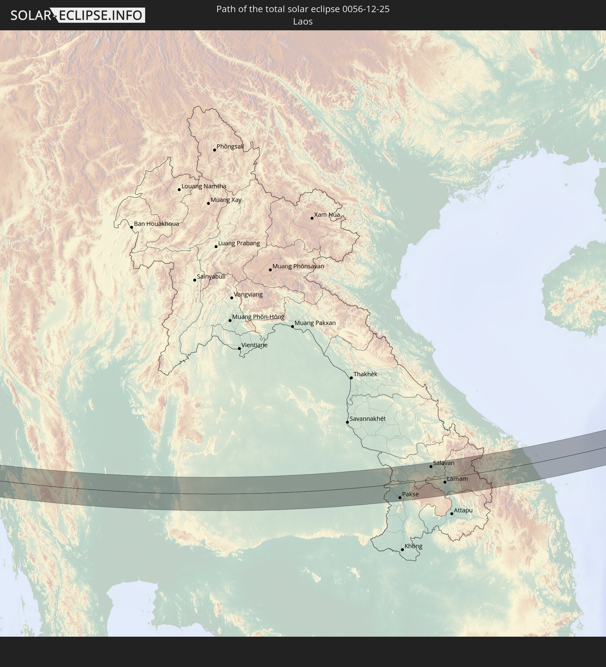
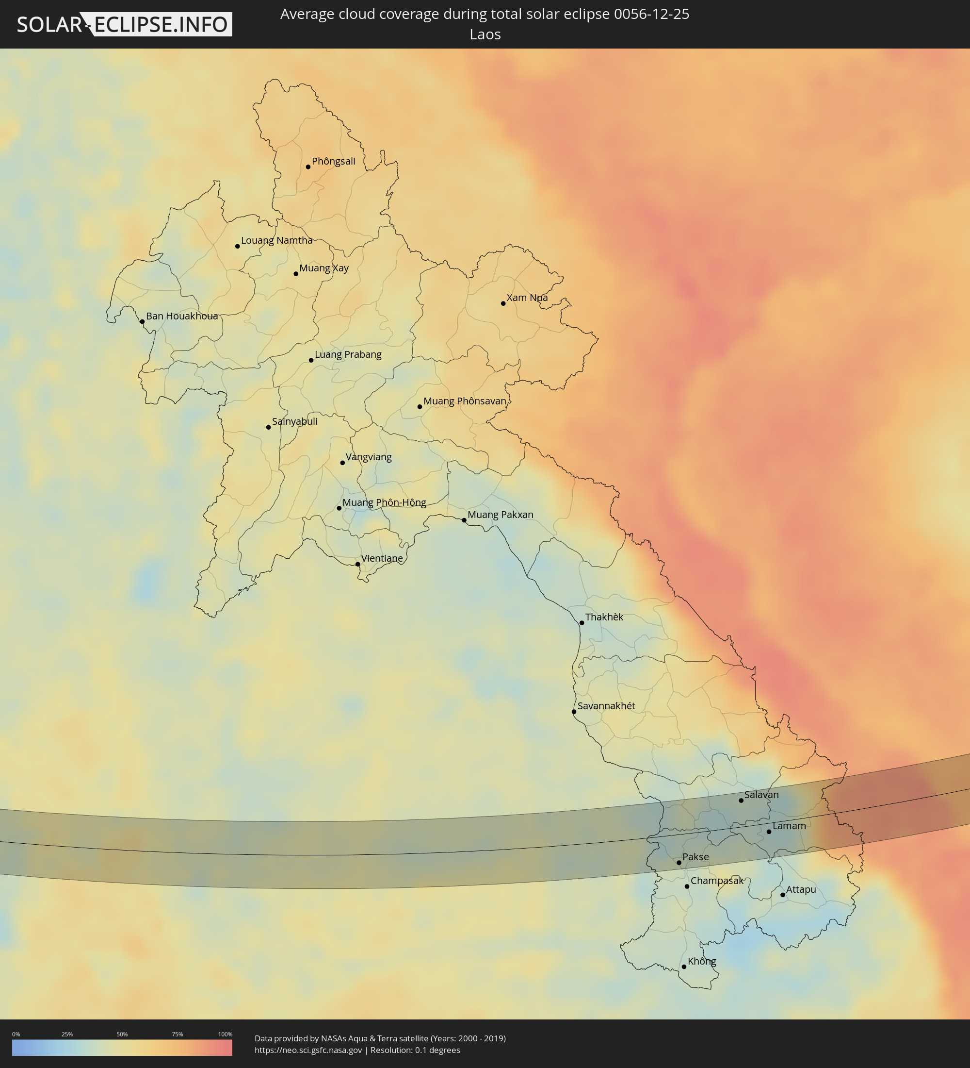 Laos
Laos
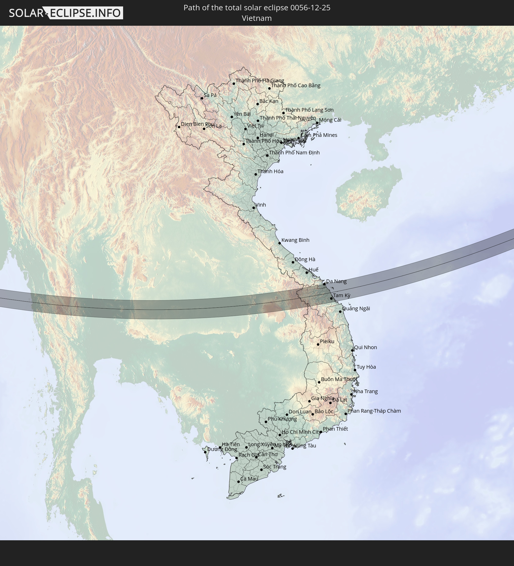
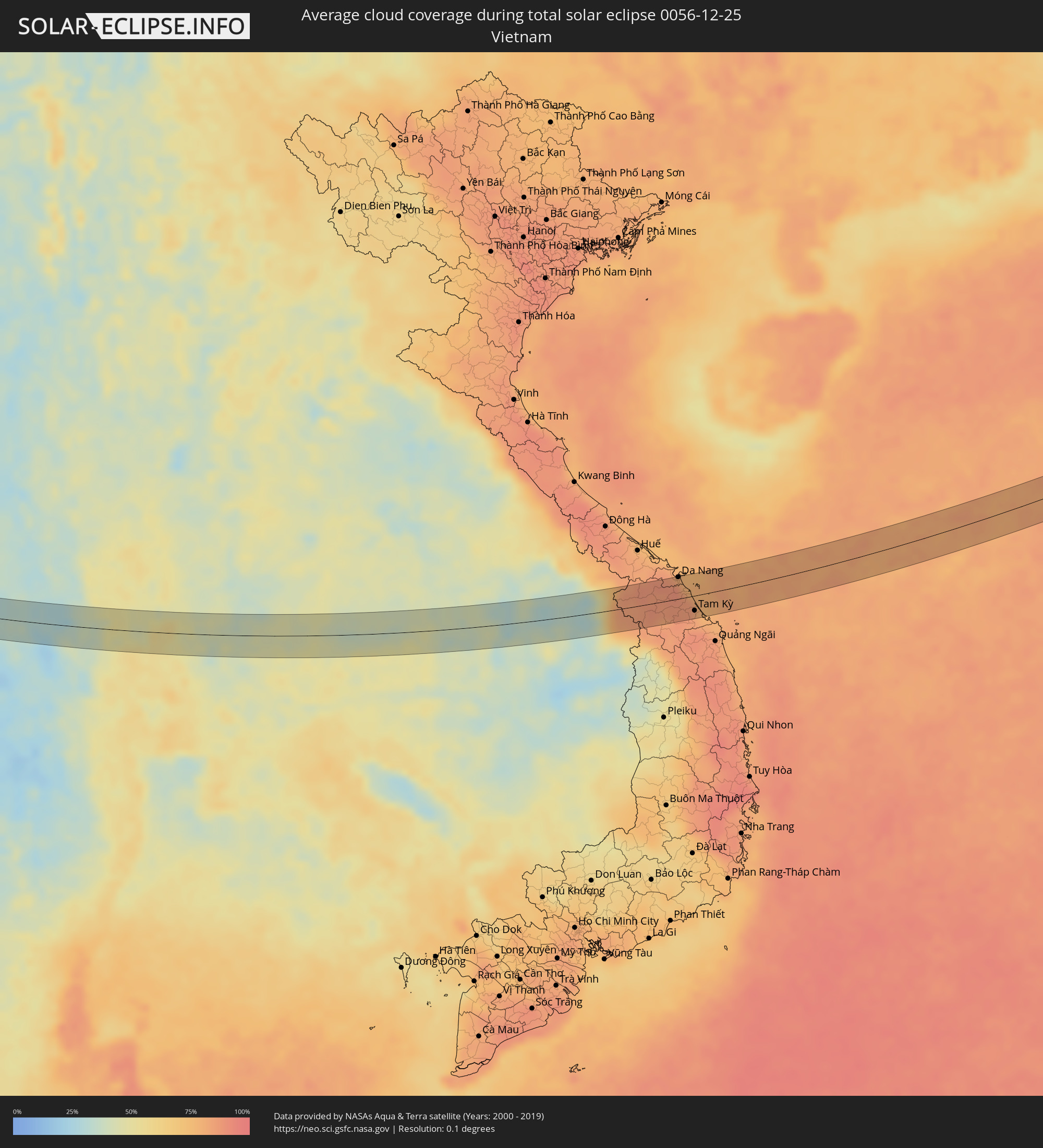 Vietnam
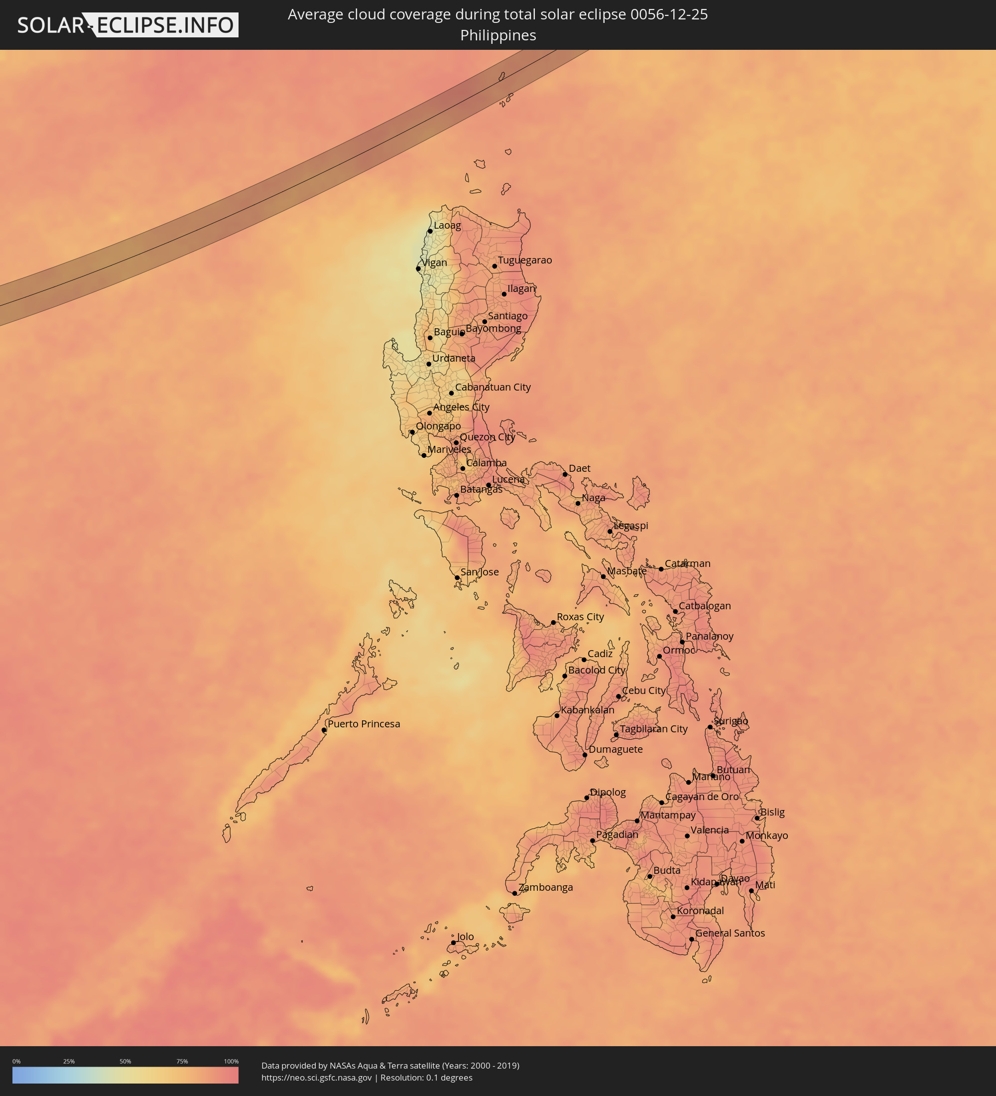 Philippines
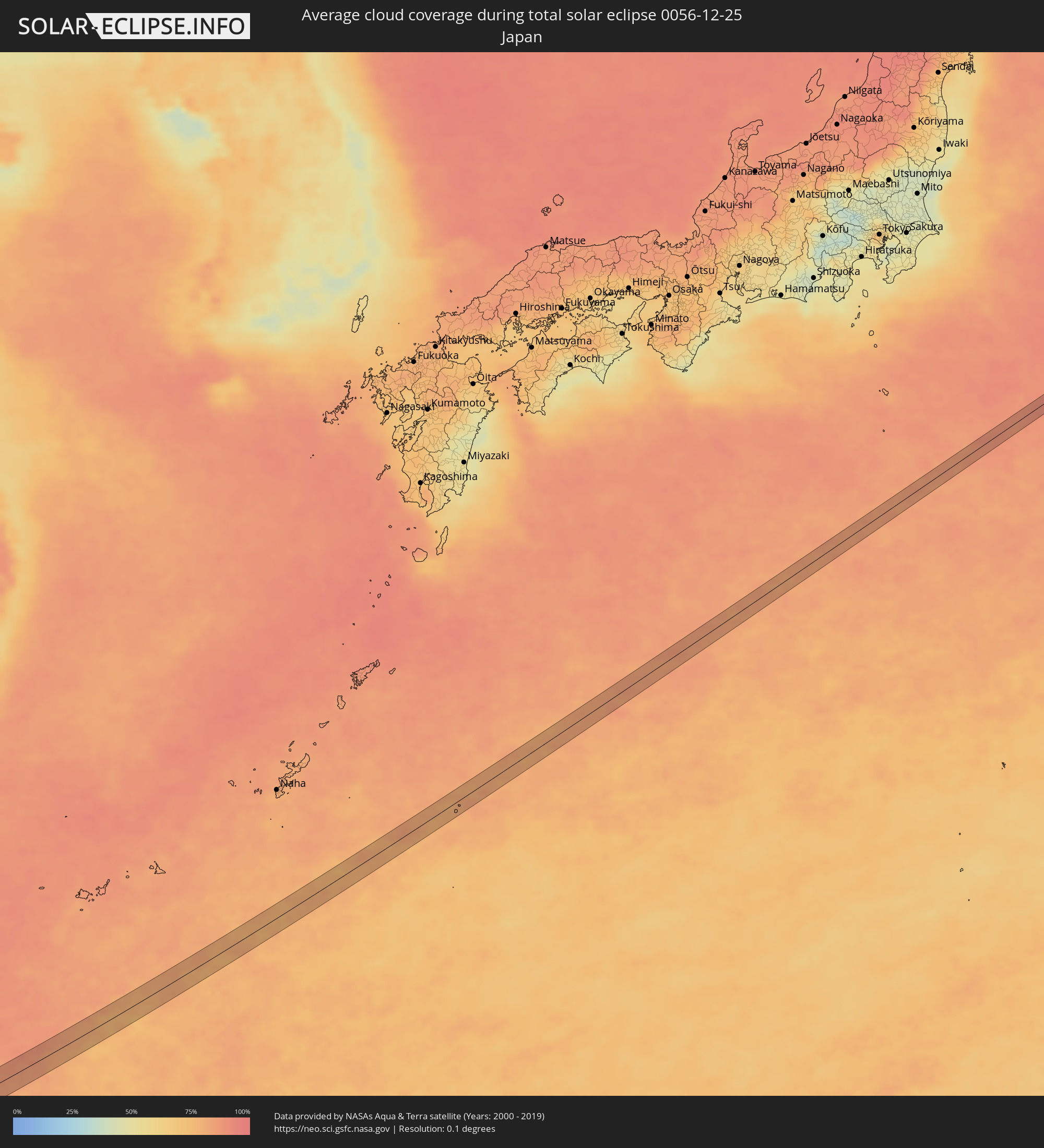 Japan
Japan
Cities inside the path of the eclipse
The following table shows all locations with a population of more than 5,000 inside the eclipse path. Cities which have more than 100,000 inhabitants are marked bold. A click at the locations opens a detailed map.
| City | Type | Eclipse duration | Local time of max. eclipse | Distance to central line | Ø Cloud coverage |
|
Bela, Balochistān
|
total | - | 07:38:29 UTC+04:28 | 10 km | 22% |
|
Kotri, Sindh
|
total | - | 07:39:21 UTC+04:28 | 6 km | 50% |
|
Hyderabad, Sindh
|
total | - | 07:39:25 UTC+04:28 | 1 km | 52% |
|
Tando Jām, Sindh
|
total | - | 07:39:35 UTC+04:28 | 10 km | 45% |
|
Chambar, Sindh
|
total | - | 07:39:43 UTC+04:28 | 9 km | 42% |
|
Tando Ghulām Ali, Sindh
|
total | - | 07:39:38 UTC+04:28 | 5 km | 37% |
|
Digri, Sindh
|
total | - | 07:39:51 UTC+04:28 | 9 km | 36% |
|
Naukot, Sindh
|
total | - | 07:39:53 UTC+04:28 | 8 km | 31% |
|
Mithi, Sindh
|
total | - | 07:40:08 UTC+04:28 | 2 km | 10% |
|
Islāmkot, Sindh
|
total | - | 07:40:27 UTC+04:28 | 11 km | 12% |
|
Rādhanpur, Gujarat
|
total | - | 08:34:08 UTC+05:21 | 13 km | 15% |
|
Un, Gujarat
|
total | - | 08:34:20 UTC+05:21 | 0 km | 19% |
|
Hārij, Gujarat
|
total | - | 08:34:20 UTC+05:21 | 14 km | 14% |
|
Chānasma, Gujarat
|
total | - | 08:34:33 UTC+05:21 | 2 km | 16% |
|
Pātan, Gujarat
|
total | - | 08:34:40 UTC+05:21 | 12 km | 23% |
|
Visnagar, Gujarat
|
total | - | 08:35:00 UTC+05:21 | 15 km | 16% |
|
Mānsa, Gujarat
|
total | - | 08:34:54 UTC+05:21 | 7 km | 19% |
|
Vijāpur, Gujarat
|
total | - | 08:35:06 UTC+05:21 | 10 km | 16% |
|
Chhala, Gujarat
|
total | - | 08:34:56 UTC+05:21 | 14 km | 18% |
|
Virpur, Gujarat
|
total | - | 08:35:37 UTC+05:21 | 5 km | 20% |
|
Lūnāvāda, Gujarat
|
total | - | 08:35:43 UTC+05:21 | 4 km | 21% |
|
Morwa, Gujarat
|
total | - | 08:35:48 UTC+05:21 | 8 km | 18% |
|
Dohad, Gujarat
|
total | - | 08:36:14 UTC+05:21 | 3 km | 13% |
|
Rānāpur, Madhya Pradesh
|
total | - | 08:36:24 UTC+05:21 | 5 km | 12% |
|
Jhābua, Madhya Pradesh
|
total | - | 08:36:34 UTC+05:21 | 10 km | 12% |
|
Rājgarh, Madhya Pradesh
|
total | - | 08:36:55 UTC+05:21 | 17 km | 11% |
|
Māndu, Madhya Pradesh
|
total | - | 08:37:13 UTC+05:21 | 4 km | 12% |
|
Dhāmnod, Madhya Pradesh
|
total | - | 08:37:13 UTC+05:21 | 8 km | 14% |
|
Maheshwar, Madhya Pradesh
|
total | - | 08:37:20 UTC+05:21 | 7 km | 14% |
|
Kasrāwad, Madhya Pradesh
|
total | - | 08:37:20 UTC+05:21 | 10 km | 12% |
|
Māndleshwar, Madhya Pradesh
|
total | - | 08:37:26 UTC+05:21 | 3 km | 15% |
|
Sanāwad, Madhya Pradesh
|
total | - | 08:37:56 UTC+05:21 | 14 km | 15% |
|
Khandwa, Madhya Pradesh
|
total | - | 08:38:03 UTC+05:21 | 10 km | 11% |
|
Achalpur, Maharashtra
|
total | - | 08:39:10 UTC+05:21 | 18 km | 12% |
|
Chāndūr Bāzār, Maharashtra
|
total | - | 08:39:29 UTC+05:21 | 10 km | 13% |
|
Morsi, Maharashtra
|
total | - | 08:39:55 UTC+05:21 | 11 km | 14% |
|
Ārvi, Maharashtra
|
total | - | 08:39:59 UTC+05:21 | 15 km | 13% |
|
Sindi, Maharashtra
|
total | - | 08:40:47 UTC+05:21 | 7 km | 12% |
|
Umred, Maharashtra
|
total | - | 08:41:27 UTC+05:21 | 16 km | 11% |
|
Kondagaon, Chhattisgarh
|
total | - | 08:44:14 UTC+05:21 | 20 km | 16% |
|
Umarkot, Chhattisgarh
|
total | - | 08:45:10 UTC+05:21 | 9 km | 13% |
|
Gunupur, Odisha
|
total | - | 08:47:33 UTC+05:21 | 9 km | 25% |
|
Parlākimidi, Andhra Pradesh
|
total | - | 08:47:52 UTC+05:21 | 12 km | 32% |
|
Palāsa, Andhra Pradesh
|
total | - | 08:48:26 UTC+05:21 | 1 km | 29% |
|
Mandasa, Andhra Pradesh
|
total | - | 08:48:35 UTC+05:21 | 11 km | 31% |
|
Sompeta, Andhra Pradesh
|
total | - | 08:48:51 UTC+05:21 | 23 km | 31% |
|
Sangkhla Buri, Kanchanaburi
|
total | - | 10:40:08 UTC+06:42 | 25 km | 22% |
|
Lan Sak, Uthai Thani
|
total | - | 10:43:31 UTC+06:42 | 18 km | 50% |
|
Huai Khot, Uthai Thani
|
total | - | 10:43:33 UTC+06:42 | 1 km | 46% |
|
Thap Than, Uthai Thani
|
total | - | 10:44:26 UTC+06:42 | 21 km | 44% |
|
Uthai Thani, Uthai Thani
|
total | - | 10:44:47 UTC+06:42 | 13 km | 47% |
|
Chai Nat, Chai Nat
|
total | - | 10:44:58 UTC+06:42 | 8 km | 53% |
|
Phayuha Khiri, Nakhon Sawan
|
total | - | 10:45:09 UTC+06:42 | 22 km | 51% |
|
Chai Badan, Lop Buri
|
total | - | 10:47:58 UTC+06:42 | 2 km | 40% |
|
Bamnet Narong, Chaiyaphum
|
total | - | 10:49:47 UTC+06:42 | 33 km | 43% |
|
Amphoe Sikhiu, Nakhon Ratchasima
|
total | - | 10:49:31 UTC+06:42 | 34 km | 43% |
|
Dan Khun Thot, Nakhon Ratchasima
|
total | - | 10:49:52 UTC+06:42 | 1 km | 45% |
|
Sung Noen, Nakhon Ratchasima
|
total | - | 10:49:51 UTC+06:42 | 34 km | 45% |
|
Non Thai, Nakhon Ratchasima
|
total | - | 10:50:46 UTC+06:42 | 0 km | 45% |
|
Nakhon Ratchasima, Nakhon Ratchasima
|
total | - | 10:50:44 UTC+06:42 | 26 km | 48% |
|
Kham Sakae Saeng, Nakhon Ratchasima
|
total | - | 10:51:09 UTC+06:42 | 15 km | 43% |
|
Non Sung, Nakhon Ratchasima
|
total | - | 10:51:19 UTC+06:42 | 2 km | 44% |
|
Phimai, Nakhon Ratchasima
|
total | - | 10:52:04 UTC+06:42 | 2 km | 47% |
|
Ban Huai Thalaeng, Nakhon Ratchasima
|
total | - | 10:52:24 UTC+06:42 | 25 km | 48% |
|
Buriram, Buriram
|
total | - | 10:53:48 UTC+06:42 | 24 km | 47% |
|
Phayakkhaphum Phisai, Maha Sarakham
|
total | - | 10:54:21 UTC+06:42 | 33 km | 40% |
|
Satuek, Buriram
|
total | - | 10:54:32 UTC+06:42 | 9 km | 39% |
|
Si Sa Ket, Sisaket
|
total | - | 10:57:38 UTC+06:42 | 17 km | 47% |
|
Ubon Ratchathani, Changwat Ubon Ratchathani
|
total | - | 10:59:19 UTC+06:42 | 8 km | 40% |
|
Warin Chamrap, Changwat Ubon Ratchathani
|
total | - | 10:59:20 UTC+06:42 | 13 km | 38% |
|
Sawang Wirawong, Changwat Ubon Ratchathani
|
total | - | 11:00:04 UTC+06:42 | 10 km | 41% |
|
Phibun Mangsahan, Changwat Ubon Ratchathani
|
total | - | 11:00:30 UTC+06:42 | 11 km | 45% |
|
Pakse, Champasak
|
total | - | 11:02:12 UTC+06:42 | 31 km | 37% |
|
Salavan, Salavan
|
total | - | 11:04:28 UTC+06:42 | 27 km | 34% |
|
Lamam, Xékong
|
total | - | 11:05:10 UTC+06:42 | 10 km | 34% |
|
Da Nang, Đà Nẵng
|
total | - | 11:34:55 UTC+07:06 | 35 km | 82% |
|
Hội An, Quảng Nam
|
total | - | 11:35:10 UTC+07:06 | 12 km | 84% |
|
Tam Kỳ, Quảng Nam
|
total | - | 11:35:26 UTC+07:06 | 24 km | 83% |