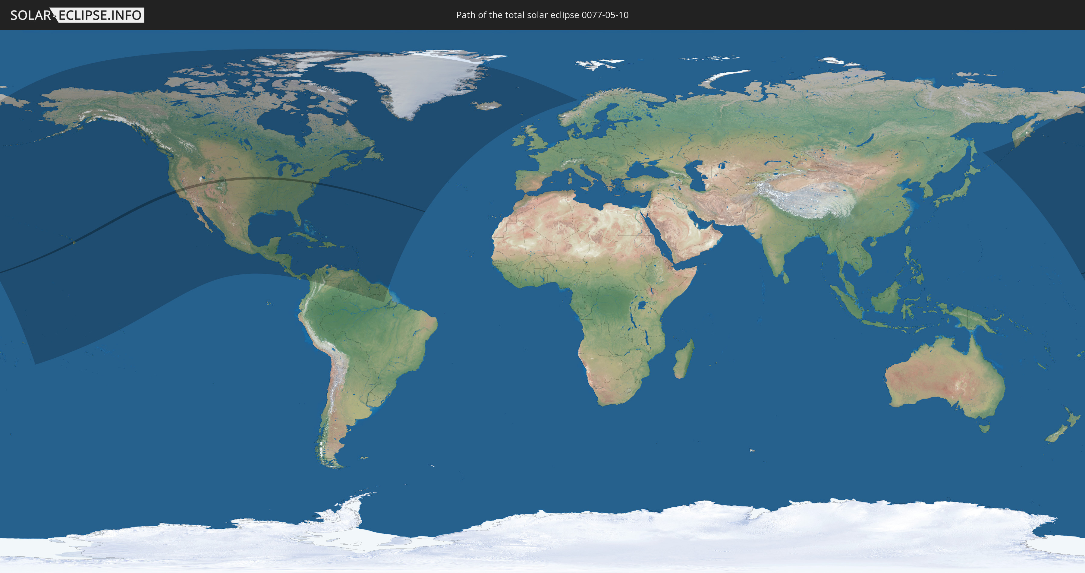
Total solar eclipse of 05/10/0077
| Day of week: | Monday |
| Maximum duration of eclipse: | 02m10s |
| Maximum width of eclipse path: | 86 km |
| Saros cycle: | 68 |
| Coverage: | 100% |
| Magnitude: | 1.0238 |
| Gamma: | 0.3493 |
Wo kann man die Sonnenfinsternis vom 05/10/0077 sehen?
Die Sonnenfinsternis am 05/10/0077 kann man in 54 Ländern als partielle Sonnenfinsternis beobachten.
Der Finsternispfad verläuft durch ein Land. Nur in diesem Land ist sie als total Sonnenfinsternis zu sehen.
In den folgenden Ländern ist die Sonnenfinsternis total zu sehen
 United States
In den folgenden Ländern ist die Sonnenfinsternis partiell zu sehen
 Russia
 United States
 United States Minor Outlying Islands
 Kiribati
 Tokelau
 American Samoa
 Cook Islands
 French Polynesia
 Canada
 Mexico
 Greenland
 Guatemala
 El Salvador
 Honduras
 Belize
 Nicaragua
 Costa Rica
 Cuba
Cuba
 Panama
 Colombia
 Cayman Islands
 The Bahamas
 Jamaica
 Haiti
Haiti
 Brazil
 Venezuela
 Turks and Caicos Islands
 Dominican Republic
 Aruba
Aruba
 Puerto Rico
 United States Virgin Islands
 Bermuda
 British Virgin Islands
 Anguilla
 Collectivity of Saint Martin
 Saint Barthélemy
 Saint Kitts and Nevis
 Antigua and Barbuda
 Montserrat
 Trinidad and Tobago
 Guadeloupe
 Grenada
 Dominica
 Saint Vincent and the Grenadines
 Guyana
 Martinique
 Saint Lucia
 Barbados
 Suriname
 Saint Pierre and Miquelon
 French Guiana
 Iceland
 Svalbard and Jan Mayen
 Faroe Islands
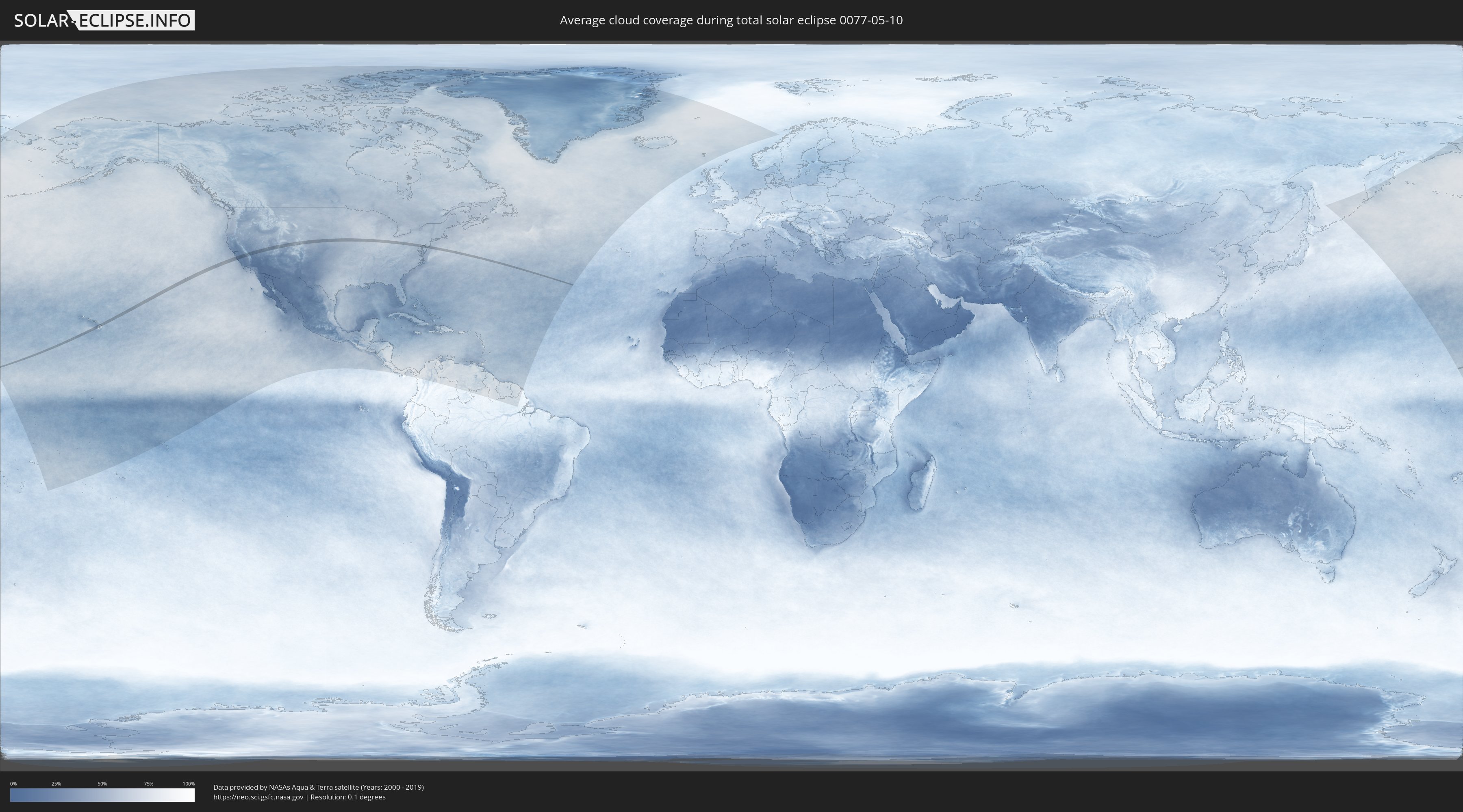
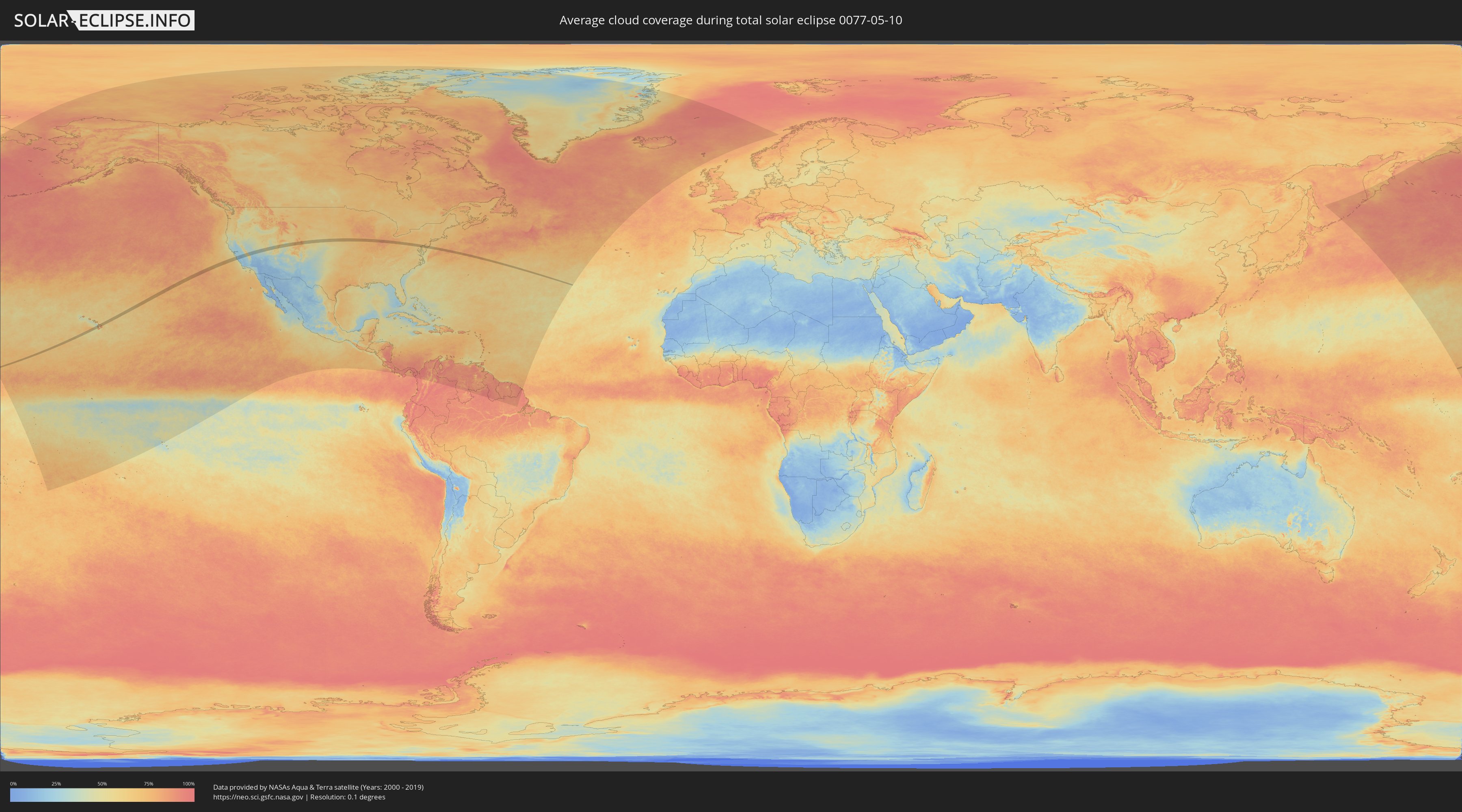
How will be the weather during the total solar eclipse on 05/10/0077?
Where is the best place to see the total solar eclipse of 05/10/0077?
The following maps show the average cloud coverage for the day of the total solar eclipse.
With the help of these maps, it is possible to find the place along the eclipse path, which has the best
chance of a cloudless sky.
Nevertheless, you should consider local circumstances and inform about the weather of your chosen
observation site.
The data is provided by NASAs satellites
AQUA and TERRA.
The cloud maps are averaged over a period of 19 years (2000 - 2019).
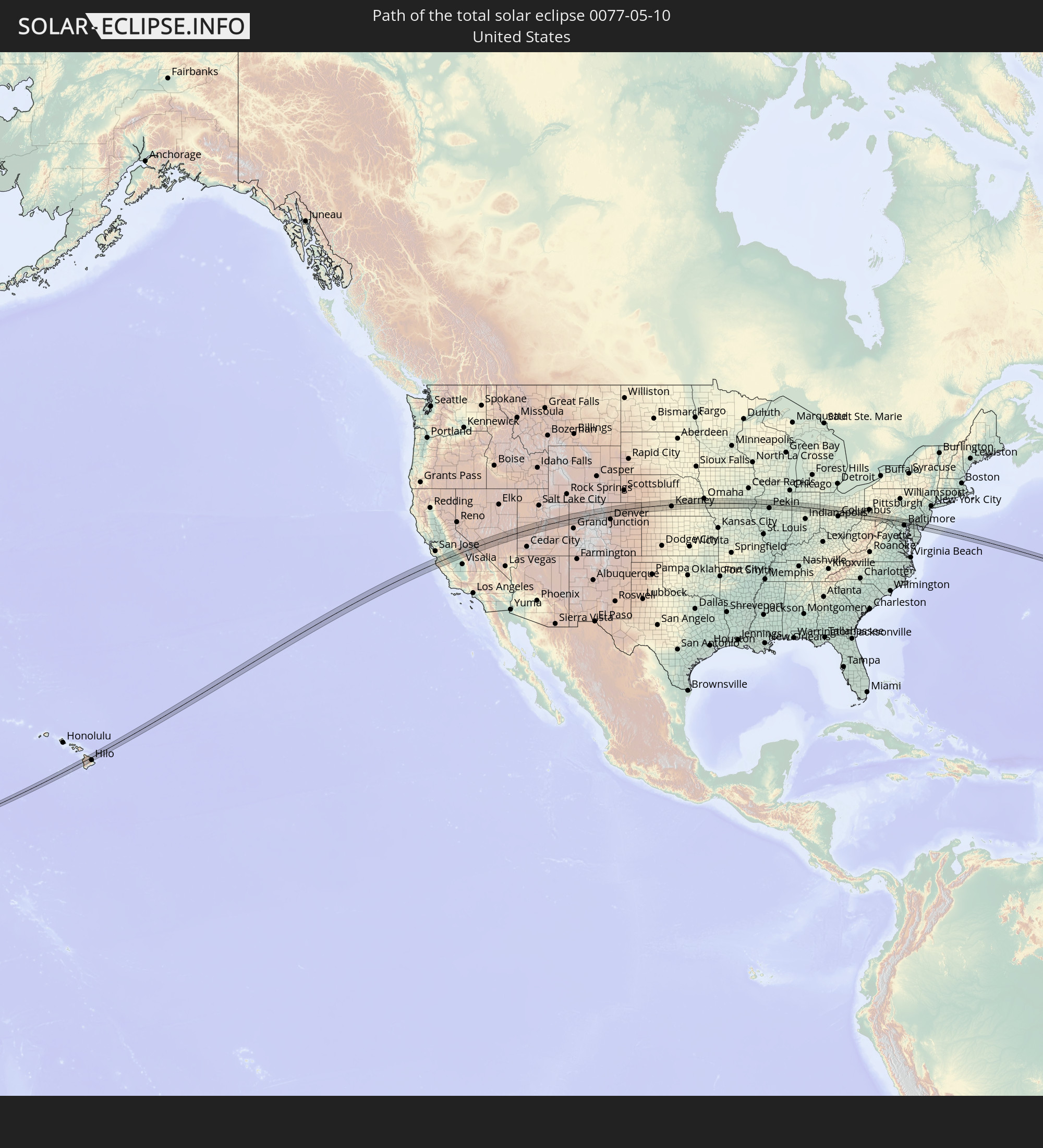
Detailed country maps
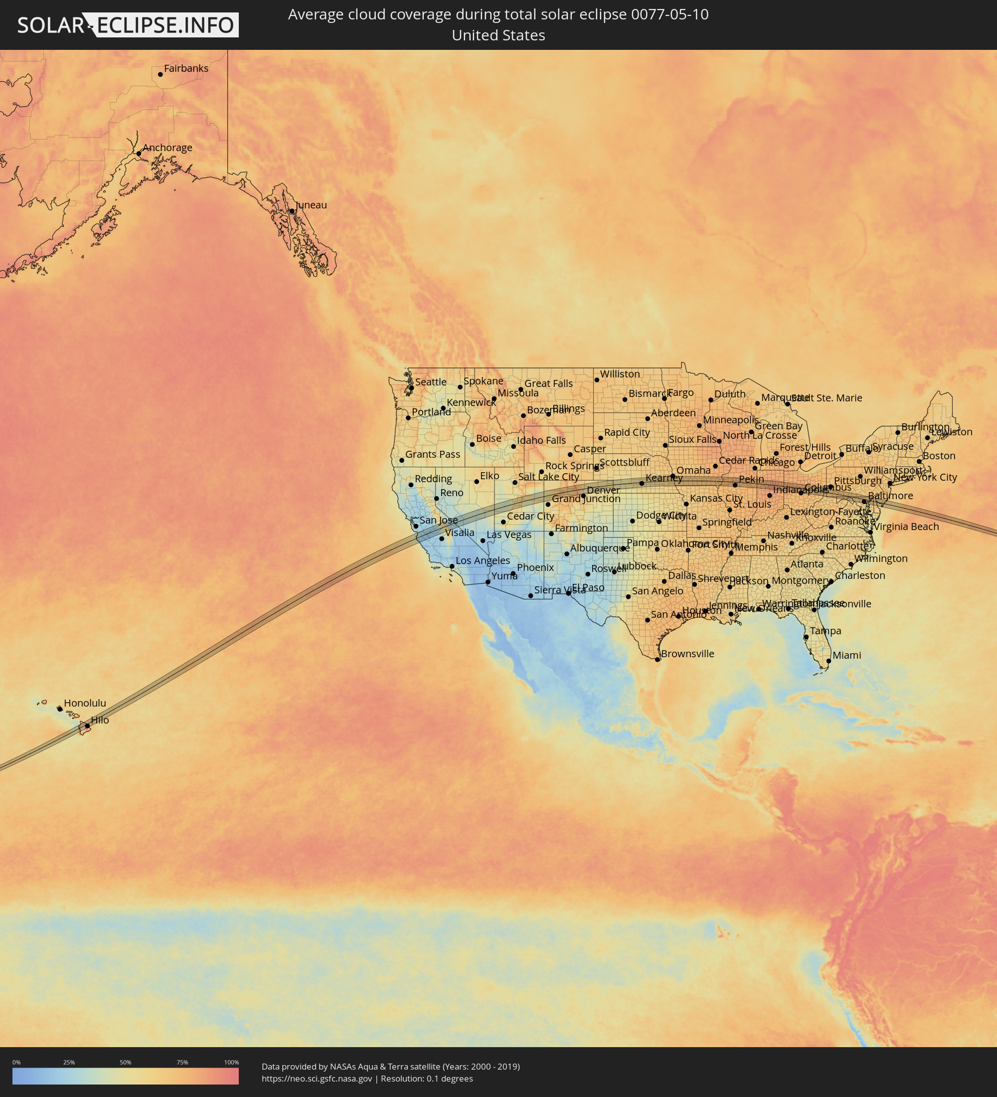 United States
Cities inside the path of the eclipse
The following table shows all locations with a population of more than 5,000 inside the eclipse path. Cities which have more than 100,000 inhabitants are marked bold. A click at the locations opens a detailed map.
| City | Type | Eclipse duration | Local time of max. eclipse | Distance to central line | Ø Cloud coverage |
|
Kailua-Kona, Hawaii
|
total | - | 07:32:36 UTC-10:30 | 8 km | 69% |
|
Kalaoa, Hawaii
|
total | - | 07:32:45 UTC-10:30 | 16 km | 80% |
|
Hōlualoa, Hawaii
|
total | - | 07:32:37 UTC-10:30 | 3 km | 87% |
|
Waikoloa Village, Hawaii
|
total | - | 07:33:08 UTC-10:30 | 28 km | 73% |
|
Waimea, Hawaii
|
total | - | 07:33:22 UTC-10:30 | 29 km | 64% |
|
Hilo, Hawaii
|
total | - | 07:33:22 UTC-10:30 | 29 km | 85% |
|
Pacific Grove, California
|
total | - | 11:20:29 UTC-08:00 | 20 km | 44% |
|
Monterey, California
|
total | - | 11:20:31 UTC-08:00 | 18 km | 44% |
|
Seaside, California
|
total | - | 11:20:37 UTC-08:00 | 17 km | 44% |
|
Marina, California
|
total | - | 11:20:49 UTC-08:00 | 23 km | 39% |
|
Castroville, California
|
total | - | 11:21:00 UTC-08:00 | 30 km | 42% |
|
Prunedale, California
|
total | - | 11:21:12 UTC-08:00 | 28 km | 37% |
|
Salinas, California
|
total | - | 11:21:07 UTC-08:00 | 17 km | 33% |
|
Gonzales, California
|
total | - | 11:21:23 UTC-08:00 | 8 km | 23% |
|
Hollister, California
|
total | - | 11:21:53 UTC-08:00 | 26 km | 27% |
|
Soledad, California
|
total | - | 11:21:33 UTC-08:00 | 20 km | 22% |
|
Greenfield, California
|
total | - | 11:21:36 UTC-08:00 | 34 km | 20% |
|
Los Banos, California
|
total | - | 11:23:19 UTC-08:00 | 29 km | 22% |
|
Merced, California
|
total | - | 11:24:23 UTC-08:00 | 41 km | 24% |
|
Firebaugh, California
|
total | - | 11:23:57 UTC-08:00 | 5 km | 18% |
|
Mendota, California
|
total | - | 11:24:00 UTC-08:00 | 19 km | 22% |
|
Chowchilla, California
|
total | - | 11:24:41 UTC-08:00 | 15 km | 25% |
|
Madera Acres, California
|
total | - | 11:25:00 UTC-08:00 | 2 km | 26% |
|
Madera, California
|
total | - | 11:24:57 UTC-08:00 | 8 km | 26% |
|
Kerman, California
|
total | - | 11:24:41 UTC-08:00 | 33 km | 24% |
|
Bonadelle Ranchos-Madera Ranchos, California
|
total | - | 11:25:23 UTC-08:00 | 12 km | 26% |
|
Fresno, California
|
total | - | 11:25:21 UTC-08:00 | 40 km | 26% |
|
Mammoth Lakes, California
|
total | - | 11:28:04 UTC-08:00 | 28 km | 60% |
|
Richfield, Utah
|
total | - | 12:44:22 UTC-07:00 | 42 km | 54% |
|
Price, Utah
|
total | - | 12:47:38 UTC-07:00 | 19 km | 51% |
|
Boulder, Colorado
|
total | - | 12:59:46 UTC-07:00 | 31 km | 65% |
|
Gunbarrel, Colorado
|
total | - | 12:59:59 UTC-07:00 | 27 km | 60% |
|
Superior, Colorado
|
total | - | 12:59:59 UTC-07:00 | 39 km | 60% |
|
Louisville, Colorado
|
total | - | 13:00:03 UTC-07:00 | 37 km | 57% |
|
Longmont, Colorado
|
total | - | 13:00:09 UTC-07:00 | 16 km | 60% |
|
Lafayette, Colorado
|
total | - | 13:00:09 UTC-07:00 | 36 km | 57% |
|
Fort Collins, Colorado
|
total | - | 13:00:14 UTC-07:00 | 29 km | 62% |
|
Loveland, Colorado
|
total | - | 13:00:14 UTC-07:00 | 8 km | 60% |
|
Erie, Colorado
|
total | - | 13:00:14 UTC-07:00 | 30 km | 56% |
|
Frederick, Colorado
|
total | - | 13:00:29 UTC-07:00 | 26 km | 54% |
|
Firestone, Colorado
|
total | - | 13:00:29 UTC-07:00 | 25 km | 54% |
|
Johnstown, Colorado
|
total | - | 13:00:34 UTC-07:00 | 0 km | 53% |
|
Windsor, Colorado
|
total | - | 13:00:36 UTC-07:00 | 15 km | 57% |
|
Brighton, Colorado
|
total | - | 13:00:43 UTC-07:00 | 40 km | 54% |
|
Fort Lupton, Colorado
|
total | - | 13:00:45 UTC-07:00 | 29 km | 54% |
|
Greeley, Colorado
|
total | - | 13:01:00 UTC-07:00 | 7 km | 53% |
|
Evans, Colorado
|
total | - | 13:01:02 UTC-07:00 | 1 km | 53% |
|
Fort Morgan, Colorado
|
total | - | 13:02:53 UTC-07:00 | 24 km | 54% |
|
Sterling, Colorado
|
total | - | 13:04:07 UTC-07:00 | 11 km | 55% |
|
Lexington, Nebraska
|
total | - | 14:11:04 UTC-06:00 | 2 km | 53% |
|
Kearney, Nebraska
|
total | - | 14:12:22 UTC-06:00 | 15 km | 58% |
|
Hastings, Nebraska
|
total | - | 14:13:45 UTC-06:00 | 31 km | 56% |
|
Grand Island, Nebraska
|
total | - | 14:13:44 UTC-06:00 | 6 km | 56% |
|
York, Nebraska
|
total | - | 14:15:11 UTC-06:00 | 3 km | 61% |
|
Seward, Nebraska
|
total | - | 14:16:06 UTC-06:00 | 1 km | 63% |
|
Crete, Nebraska
|
total | - | 14:16:27 UTC-06:00 | 32 km | 59% |
|
Lincoln, Nebraska
|
total | - | 14:16:56 UTC-06:00 | 14 km | 62% |
|
Elkhorn, Nebraska
|
total | - | 14:17:33 UTC-06:00 | 39 km | 66% |
|
Chalco, Nebraska
|
total | - | 14:17:45 UTC-06:00 | 27 km | 67% |
|
Papillion, Nebraska
|
total | - | 14:17:57 UTC-06:00 | 24 km | 67% |
|
La Vista, Nebraska
|
total | - | 14:17:58 UTC-06:00 | 27 km | 67% |
|
Omaha, Nebraska
|
total | - | 14:18:06 UTC-06:00 | 35 km | 67% |
|
Plattsmouth, Nebraska
|
total | - | 14:18:18 UTC-06:00 | 8 km | 65% |
|
Nebraska City, Nebraska
|
total | - | 14:18:29 UTC-06:00 | 30 km | 66% |
|
Creston, Iowa
|
total | - | 14:21:01 UTC-06:00 | 11 km | 68% |
|
Ottumwa, Iowa
|
total | - | 14:24:26 UTC-06:00 | 9 km | 70% |
|
Fairfield, Iowa
|
total | - | 14:25:12 UTC-06:00 | 9 km | 73% |
|
Mount Pleasant, Iowa
|
total | - | 14:25:54 UTC-06:00 | 5 km | 74% |
|
Fort Madison, Iowa
|
total | - | 14:26:31 UTC-06:00 | 31 km | 70% |
|
Burlington, Iowa
|
total | - | 14:26:45 UTC-06:00 | 11 km | 73% |
|
Monmouth, Illinois
|
total | - | 14:27:27 UTC-06:00 | 2 km | 76% |
|
Galesburg, Illinois
|
total | - | 14:27:52 UTC-06:00 | 8 km | 76% |
|
Canton, Illinois
|
total | - | 14:28:41 UTC-06:00 | 34 km | 73% |
|
Bartonville, Illinois
|
total | - | 14:29:14 UTC-06:00 | 22 km | 75% |
|
Peoria, Illinois
|
total | - | 14:29:18 UTC-06:00 | 17 km | 74% |
|
East Peoria, Illinois
|
total | - | 14:29:20 UTC-06:00 | 20 km | 74% |
|
Morton, Illinois
|
total | - | 14:29:34 UTC-06:00 | 25 km | 74% |
|
Washington, Illinois
|
total | - | 14:29:35 UTC-06:00 | 15 km | 75% |
|
Normal, Illinois
|
total | - | 14:30:23 UTC-06:00 | 34 km | 76% |
|
Streator, Illinois
|
total | - | 14:30:11 UTC-06:00 | 35 km | 78% |
|
Pontiac, Illinois
|
total | - | 14:30:41 UTC-06:00 | 9 km | 77% |
|
West Lafayette, Indiana
|
total | - | 15:33:40 UTC-05:00 | 29 km | 80% |
|
Lafayette, Indiana
|
total | - | 15:33:43 UTC-05:00 | 30 km | 80% |
|
Logansport, Indiana
|
total | - | 15:34:13 UTC-05:00 | 12 km | 82% |
|
Kokomo, Indiana
|
total | - | 15:34:45 UTC-05:00 | 16 km | 83% |
|
Peru, Indiana
|
total | - | 15:34:38 UTC-05:00 | 14 km | 82% |
|
Mount Vernon, Indiana
|
total | - | 15:35:03 UTC-05:00 | 7 km | 84% |
|
Wabash, Indiana
|
total | - | 15:34:57 UTC-05:00 | 21 km | 84% |
|
Marion, Indiana
|
total | - | 15:35:23 UTC-05:00 | 4 km | 84% |
|
Huntington, Indiana
|
total | - | 15:35:21 UTC-05:00 | 33 km | 82% |
|
Bluffton, Indiana
|
total | - | 15:35:56 UTC-05:00 | 20 km | 80% |
|
Decatur, Indiana
|
total | - | 15:36:12 UTC-05:00 | 33 km | 80% |
|
Celina, Ohio
|
total | - | 15:36:56 UTC-05:00 | 5 km | 80% |
|
Saint Marys, Ohio
|
total | - | 15:37:11 UTC-05:00 | 7 km | 78% |
|
Wapakoneta, Ohio
|
total | - | 15:37:26 UTC-05:00 | 11 km | 79% |
|
Sidney, Ohio
|
total | - | 15:37:44 UTC-05:00 | 20 km | 79% |
|
Lima, Ohio
|
total | - | 15:37:24 UTC-05:00 | 32 km | 79% |
|
Bellefontaine, Ohio
|
total | - | 15:38:13 UTC-05:00 | 7 km | 76% |
|
Urbana, Ohio
|
total | - | 15:38:27 UTC-05:00 | 35 km | 74% |
|
Kenton, Ohio
|
total | - | 15:38:10 UTC-05:00 | 26 km | 79% |
|
Marysville, Ohio
|
total | - | 15:38:51 UTC-05:00 | 16 km | 74% |
|
Marion, Ohio
|
total | - | 15:38:52 UTC-05:00 | 25 km | 77% |
|
Dublin, Ohio
|
total | - | 15:39:19 UTC-05:00 | 28 km | 71% |
|
Powell, Ohio
|
total | - | 15:39:19 UTC-05:00 | 22 km | 73% |
|
Delaware, Ohio
|
total | - | 15:39:12 UTC-05:00 | 6 km | 73% |
|
Worthington, Ohio
|
total | - | 15:39:27 UTC-05:00 | 28 km | 72% |
|
Lewis Center, Ohio
|
total | - | 15:39:22 UTC-05:00 | 16 km | 74% |
|
Westerville, Ohio
|
total | - | 15:39:33 UTC-05:00 | 23 km | 73% |
|
New Albany, Ohio
|
total | - | 15:39:45 UTC-05:00 | 27 km | 74% |
|
Mount Vernon, Ohio
|
total | - | 15:39:53 UTC-05:00 | 11 km | 76% |
|
Heath, Ohio
|
total | - | 15:40:17 UTC-05:00 | 29 km | 75% |
|
Newark, Ohio
|
total | - | 15:40:18 UTC-05:00 | 25 km | 73% |
|
Zanesville, Ohio
|
total | - | 15:40:55 UTC-05:00 | 33 km | 73% |
|
Coshocton, Ohio
|
total | - | 15:40:48 UTC-05:00 | 6 km | 73% |
|
Cambridge, Ohio
|
total | - | 15:41:22 UTC-05:00 | 17 km | 71% |
|
Moundsville, West Virginia
|
total | - | 15:42:32 UTC-05:00 | 18 km | 67% |
|
Martins Ferry, Ohio
|
total | - | 15:42:24 UTC-05:00 | 1 km | 67% |
|
Wheeling, West Virginia
|
total | - | 15:42:26 UTC-05:00 | 2 km | 67% |
|
Steubenville, Ohio
|
total | - | 15:42:15 UTC-05:00 | 33 km | 66% |
|
Washington, Pennsylvania
|
total | - | 15:42:54 UTC-05:00 | 16 km | 69% |
|
Canonsburg, Pennsylvania
|
total | - | 15:42:53 UTC-05:00 | 27 km | 69% |
|
Maple Glen, Pennsylvania
|
total | - | 15:43:23 UTC-05:00 | 3 km | 65% |
|
California, Pennsylvania
|
total | - | 15:43:26 UTC-05:00 | 10 km | 67% |
|
Monessen, Pennsylvania
|
total | - | 15:43:22 UTC-05:00 | 19 km | 67% |
|
Cheat Lake, West Virginia
|
total | - | 15:43:52 UTC-05:00 | 33 km | 64% |
|
Uniontown, Pennsylvania
|
total | - | 15:43:48 UTC-05:00 | 6 km | 70% |
|
Connellsville, Pennsylvania
|
total | - | 15:43:51 UTC-05:00 | 9 km | 69% |
|
Somerset, Pennsylvania
|
total | - | 15:44:27 UTC-05:00 | 15 km | 73% |
|
Frostburg, Maryland
|
total | - | 15:44:58 UTC-05:00 | 21 km | 68% |
|
Cumberland, Maryland
|
total | - | 15:45:10 UTC-05:00 | 19 km | 66% |
|
Martinsburg, West Virginia
|
total | - | 15:46:16 UTC-05:00 | 28 km | 64% |
|
Halfway, Maryland
|
total | - | 15:46:20 UTC-05:00 | 7 km | 62% |
|
Hagerstown, Maryland
|
total | - | 15:46:22 UTC-05:00 | 4 km | 64% |
|
Chambersburg, Pennsylvania
|
total | - | 15:46:08 UTC-05:00 | 30 km | 65% |
|
Robinwood, Maryland
|
total | - | 15:46:26 UTC-05:00 | 3 km | 64% |
|
Waynesboro, Pennsylvania
|
total | - | 15:46:24 UTC-05:00 | 11 km | 65% |
|
Ballenger Creek, Maryland
|
total | - | 15:46:57 UTC-05:00 | 29 km | 65% |
|
Frederick, Maryland
|
total | - | 15:46:56 UTC-05:00 | 24 km | 65% |
|
Urbana, Maryland
|
total | - | 15:47:05 UTC-05:00 | 32 km | 63% |
|
Gettysburg, Pennsylvania
|
total | - | 15:46:42 UTC-05:00 | 25 km | 67% |
|
Linganore, Maryland
|
total | - | 15:47:08 UTC-05:00 | 17 km | 64% |
|
Taneytown, Maryland
|
total | - | 15:46:57 UTC-05:00 | 7 km | 65% |
|
Mount Airy, Maryland
|
total | - | 15:47:15 UTC-05:00 | 23 km | 64% |
|
Westminster, Maryland
|
total | - | 15:47:13 UTC-05:00 | 1 km | 67% |
|
Hanover, Pennsylvania
|
total | - | 15:47:00 UTC-05:00 | 26 km | 66% |
|
Parkville, Pennsylvania
|
total | - | 15:47:03 UTC-05:00 | 24 km | 66% |
|
Hampstead, Maryland
|
total | - | 15:47:21 UTC-05:00 | 7 km | 67% |
|
Reisterstown, Maryland
|
total | - | 15:47:30 UTC-05:00 | 8 km | 67% |
|
Ellicott City, Maryland
|
total | - | 15:47:45 UTC-05:00 | 29 km | 65% |
|
Owings Mills, Maryland
|
total | - | 15:47:37 UTC-05:00 | 12 km | 66% |
|
Milford Mill, Maryland
|
total | - | 15:47:42 UTC-05:00 | 20 km | 65% |
|
Ilchester, Maryland
|
total | - | 15:47:48 UTC-05:00 | 31 km | 65% |
|
Garrison, Maryland
|
total | - | 15:47:39 UTC-05:00 | 14 km | 66% |
|
Lochearn, Maryland
|
total | - | 15:47:45 UTC-05:00 | 20 km | 65% |
|
Arbutus, Maryland
|
total | - | 15:47:52 UTC-05:00 | 29 km | 65% |
|
Lansdowne, Maryland
|
total | - | 15:47:55 UTC-05:00 | 29 km | 64% |
|
Mays Chapel, Maryland
|
total | - | 15:47:44 UTC-05:00 | 9 km | 65% |
|
Cockeysville, Maryland
|
total | - | 15:47:42 UTC-05:00 | 3 km | 65% |
|
Hunt Valley, Maryland
|
total | - | 15:47:41 UTC-05:00 | 1 km | 65% |
|
Baltimore Highlands, Maryland
|
total | - | 15:47:57 UTC-05:00 | 30 km | 61% |
|
Lutherville, Maryland
|
total | - | 15:47:46 UTC-05:00 | 10 km | 65% |
|
Timonium, Maryland
|
total | - | 15:47:46 UTC-05:00 | 8 km | 65% |
|
Brooklyn Park, Maryland
|
total | - | 15:47:59 UTC-05:00 | 31 km | 61% |
|
Baltimore, Maryland
|
total | - | 15:47:55 UTC-05:00 | 24 km | 63% |
|
Overlea, Maryland
|
total | - | 15:47:57 UTC-05:00 | 14 km | 64% |
|
Rosedale, Maryland
|
total | - | 15:48:00 UTC-05:00 | 19 km | 62% |
|
Rossville, Maryland
|
total | - | 15:48:01 UTC-05:00 | 16 km | 62% |
|
Perry Hall, Maryland
|
total | - | 15:47:57 UTC-05:00 | 8 km | 64% |
|
Edgemere, Maryland
|
total | - | 15:48:09 UTC-05:00 | 26 km | 57% |
|
Middle River, Maryland
|
total | - | 15:48:04 UTC-05:00 | 16 km | 61% |
|
White Marsh, Maryland
|
total | - | 15:48:01 UTC-05:00 | 10 km | 63% |
|
Fallston, Maryland
|
total | - | 15:47:54 UTC-05:00 | 4 km | 63% |
|
Bowleys Quarters, Maryland
|
total | - | 15:48:07 UTC-05:00 | 15 km | 61% |
|
Joppatowne, Maryland
|
total | - | 15:48:01 UTC-05:00 | 1 km | 63% |
|
Bel Air, Maryland
|
total | - | 15:47:57 UTC-05:00 | 8 km | 63% |
|
South Bel Air, Maryland
|
total | - | 15:47:58 UTC-05:00 | 8 km | 63% |
|
Edgewood, Maryland
|
total | - | 15:48:08 UTC-05:00 | 4 km | 63% |
|
Riverside, Maryland
|
total | - | 15:48:07 UTC-05:00 | 3 km | 62% |
|
Aberdeen, Maryland
|
total | - | 15:48:10 UTC-05:00 | 8 km | 62% |
|
Havre de Grace, Maryland
|
total | - | 15:48:12 UTC-05:00 | 14 km | 63% |
|
Elkton, Maryland
|
total | - | 15:48:25 UTC-05:00 | 24 km | 63% |
|
Glasgow, Delaware
|
total | - | 15:48:30 UTC-05:00 | 26 km | 64% |
|
Middletown, Delaware
|
total | - | 15:48:42 UTC-05:00 | 9 km | 64% |
|
Bear, Delaware
|
total | - | 15:48:34 UTC-05:00 | 30 km | 64% |
|
Smyrna, Delaware
|
total | - | 15:48:58 UTC-05:00 | 5 km | 65% |
|
Dover, Delaware
|
total | - | 15:49:11 UTC-05:00 | 19 km | 63% |
|
Bridgeton, New Jersey
|
total | - | 15:49:12 UTC-05:00 | 15 km | 60% |
|
Millville, New Jersey
|
total | - | 15:49:26 UTC-05:00 | 16 km | 62% |
|
Vineland, New Jersey
|
total | - | 15:49:21 UTC-05:00 | 26 km | 69% |
|
Villas, New Jersey
|
total | - | 15:49:55 UTC-05:00 | 23 km | 56% |
|
Somers Point, New Jersey
|
total | - | 15:49:57 UTC-05:00 | 15 km | 66% |
|
Linwood, New Jersey
|
total | - | 15:49:57 UTC-05:00 | 18 km | 66% |
|
Ocean City, New Jersey
|
total | - | 15:50:01 UTC-05:00 | 11 km | 66% |
|
Northfield, New Jersey
|
total | - | 15:49:56 UTC-05:00 | 22 km | 65% |
|
Pleasantville, New Jersey
|
total | - | 15:49:57 UTC-05:00 | 24 km | 65% |
|
Margate City, New Jersey
|
total | - | 15:50:02 UTC-05:00 | 18 km | 66% |
|
Absecon, New Jersey
|
total | - | 15:49:56 UTC-05:00 | 29 km | 65% |
|
Ventnor City, New Jersey
|
total | - | 15:50:03 UTC-05:00 | 20 km | 66% |
|
Atlantic City, New Jersey
|
total | - | 15:50:04 UTC-05:00 | 23 km | 65% |
|
Brigantine, New Jersey
|
total | - | 15:50:05 UTC-05:00 | 30 km | 65% |