Total solar eclipse of 05/25/0309
| Day of week: | Tuesday |
| Maximum duration of eclipse: | 06m45s |
| Maximum width of eclipse path: | 258 km |
| Saros cycle: | 81 |
| Coverage: | 100% |
| Magnitude: | 1.0799 |
| Gamma: | 0.0334 |
Wo kann man die Sonnenfinsternis vom 05/25/0309 sehen?
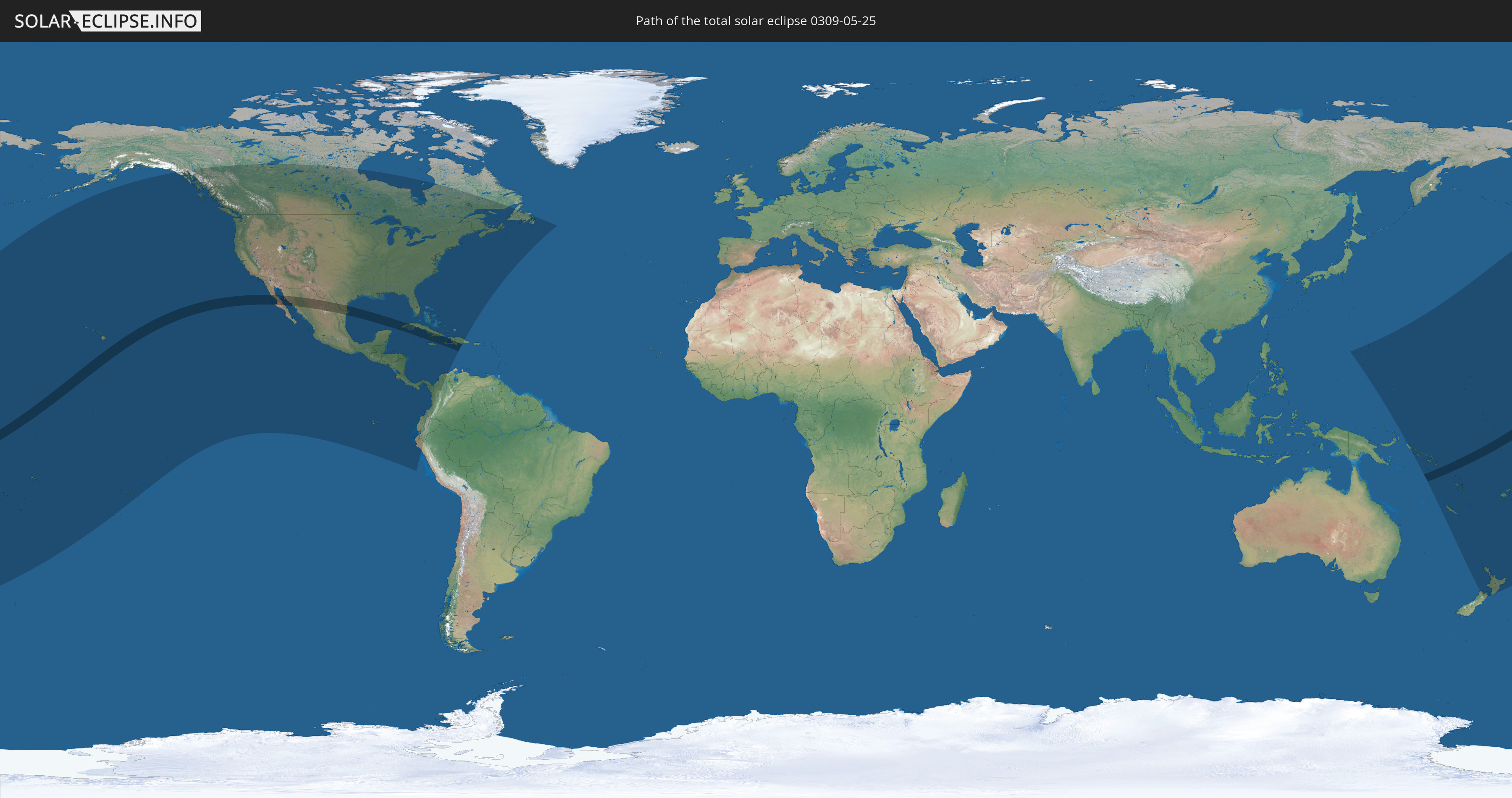
Die Sonnenfinsternis am 05/25/0309 kann man in 46 Ländern als partielle Sonnenfinsternis beobachten.
Der Finsternispfad verläuft durch 9 Länder. Nur in diesen Ländern ist sie als total Sonnenfinsternis zu sehen.
In den folgenden Ländern ist die Sonnenfinsternis total zu sehen
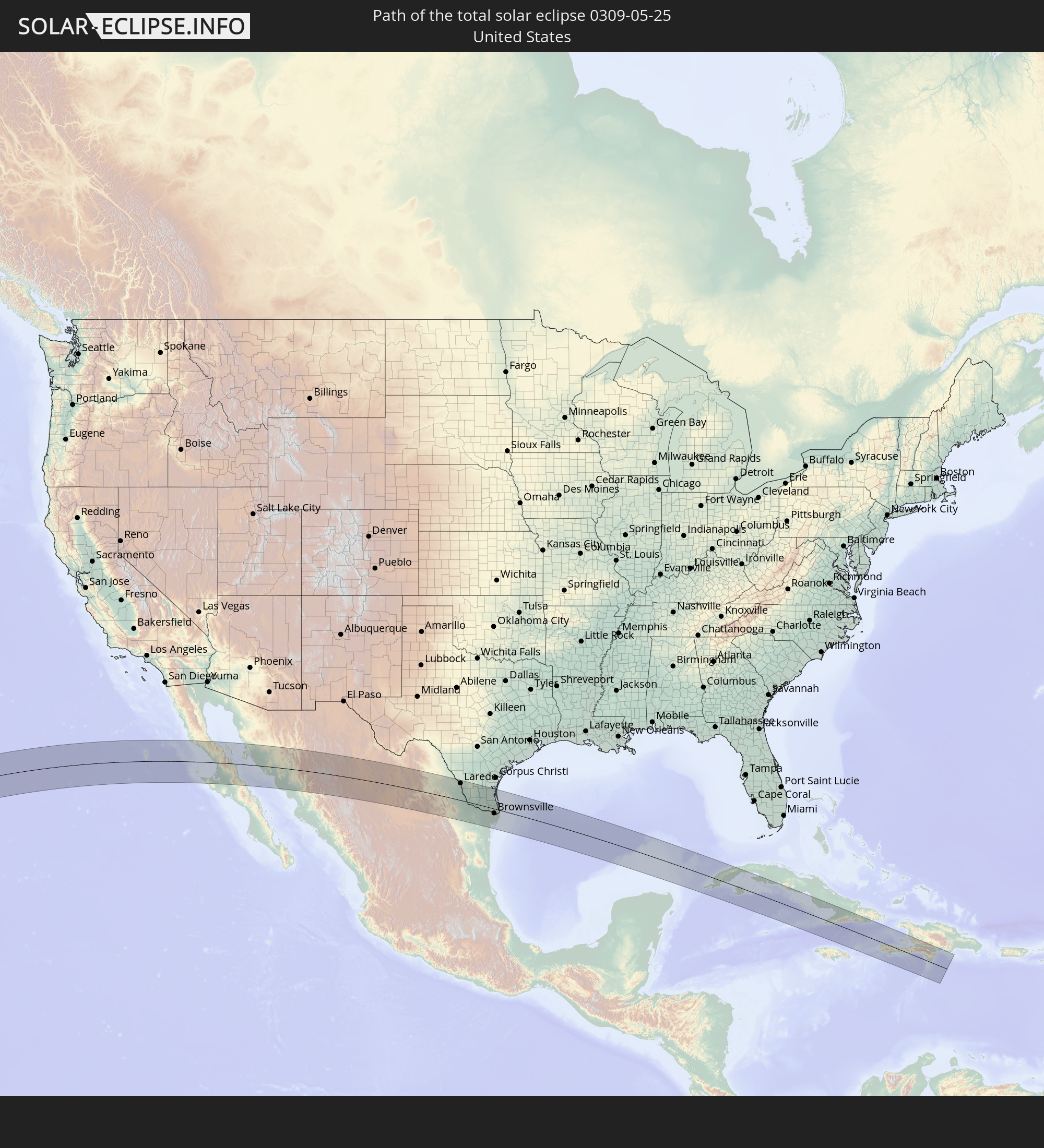 United States
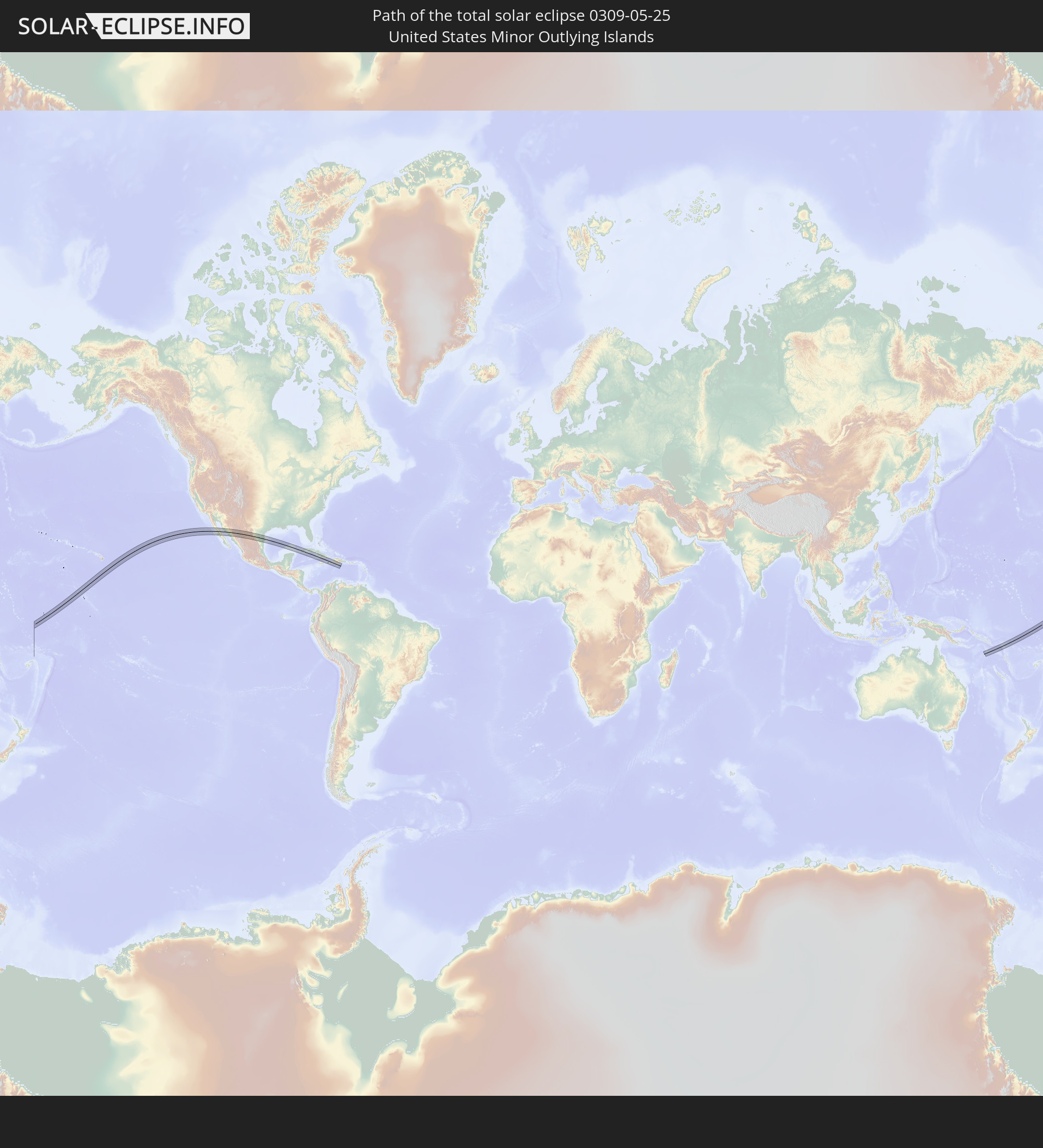 United States Minor Outlying Islands
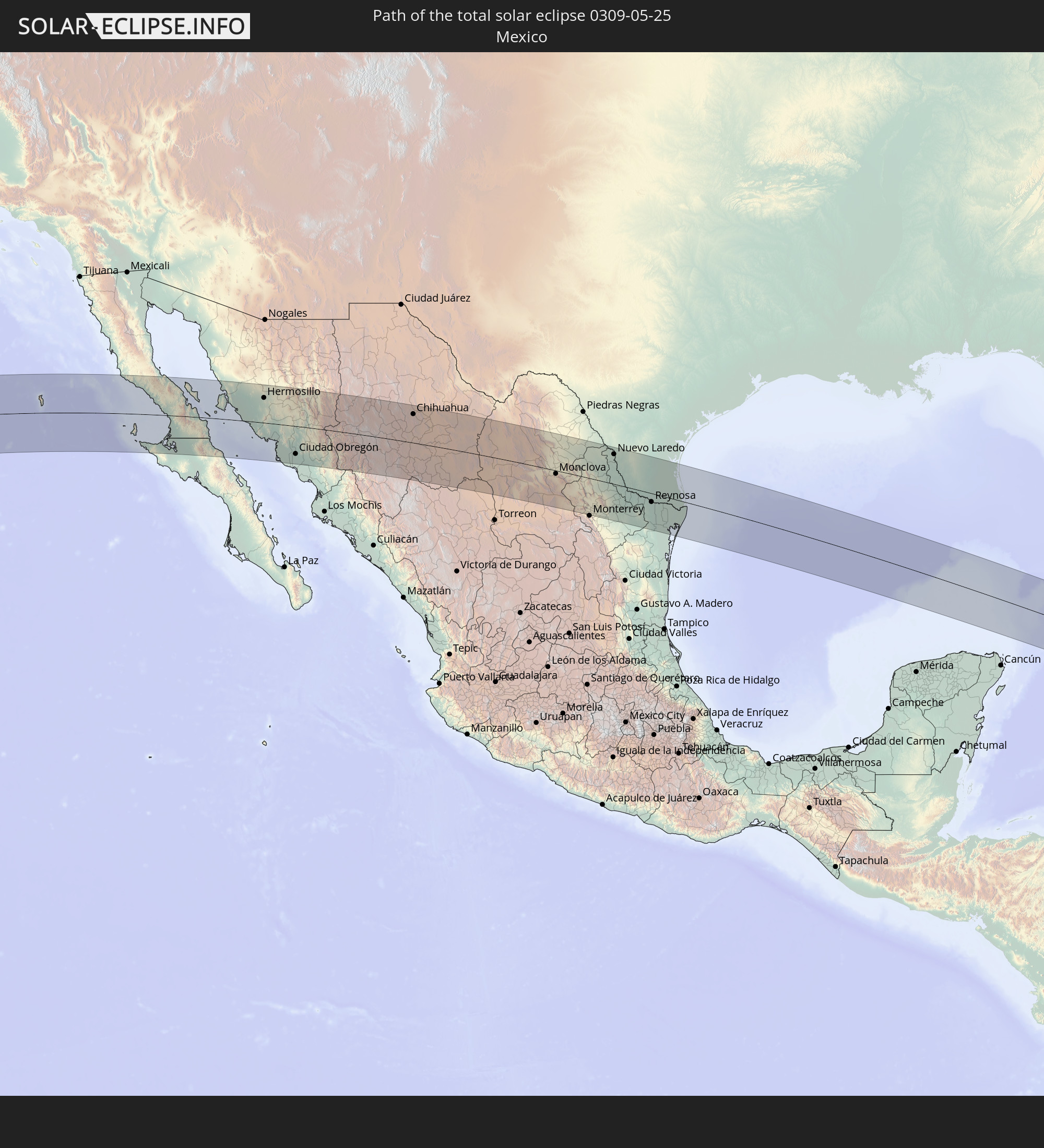 Mexico
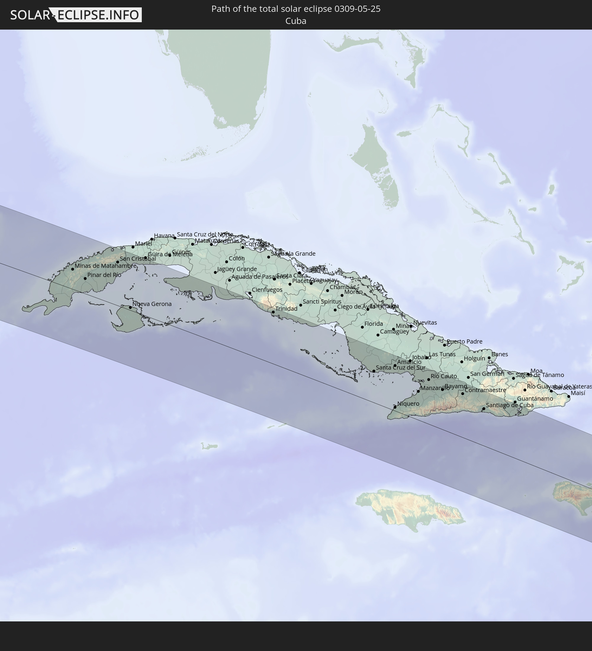 Cuba
Cuba
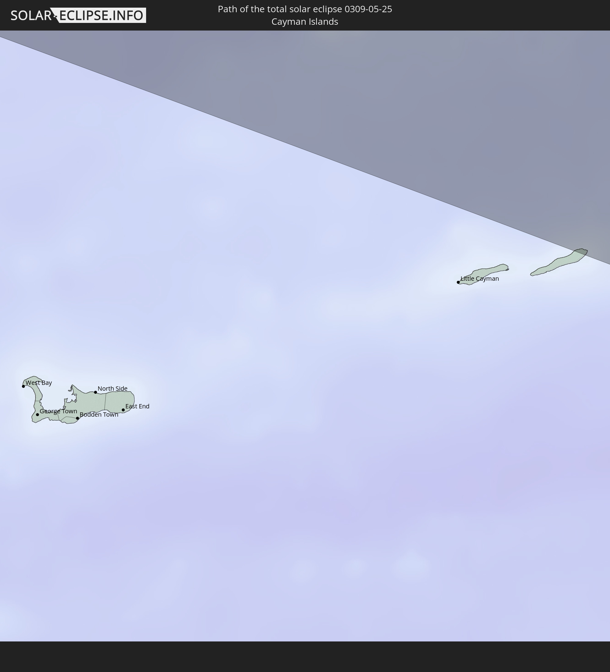 Cayman Islands
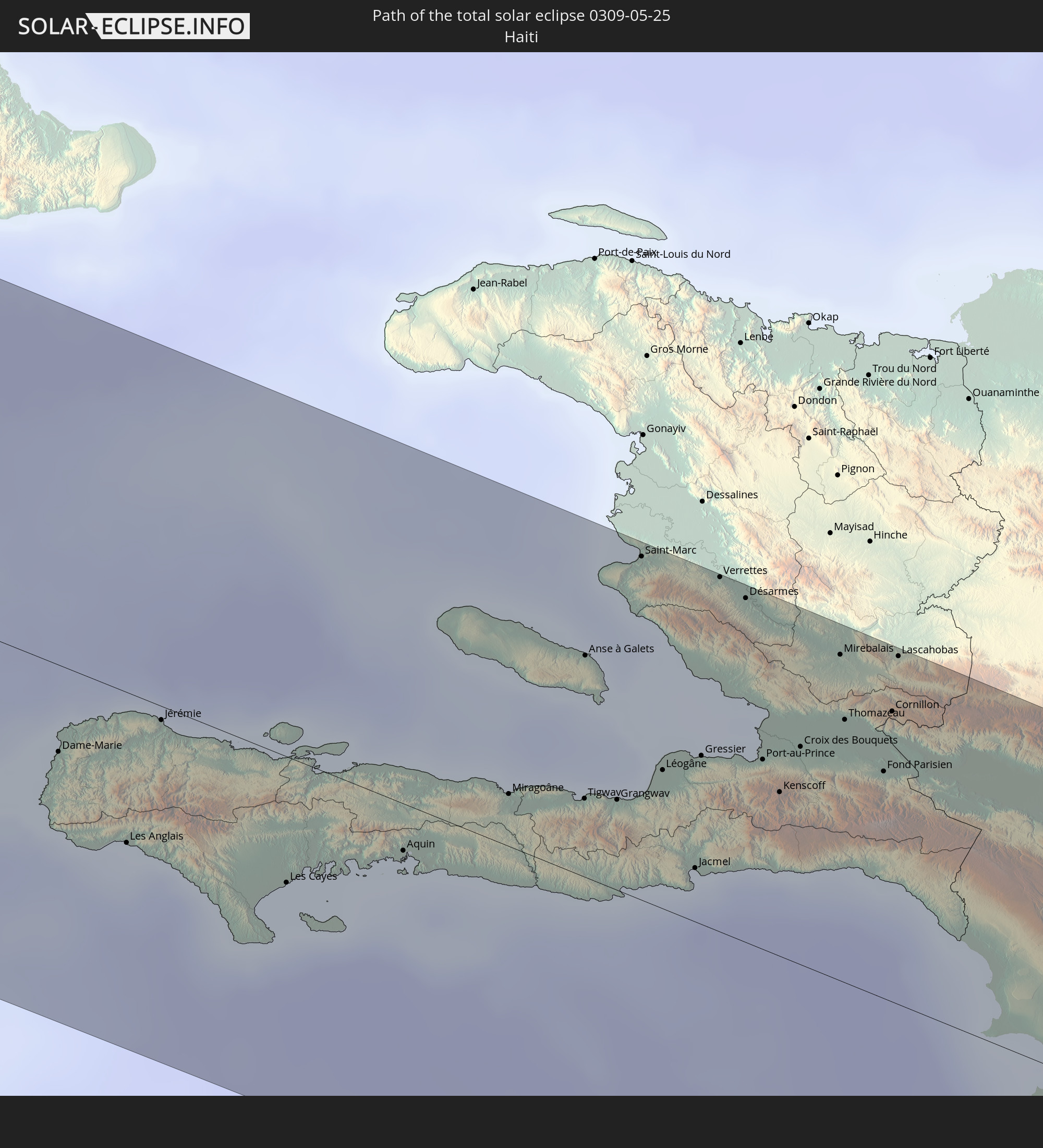 Haiti
Haiti
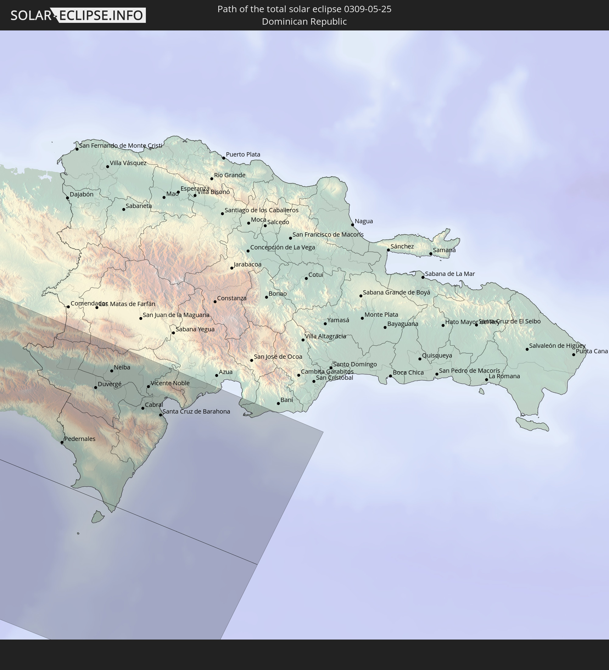 Dominican Republic
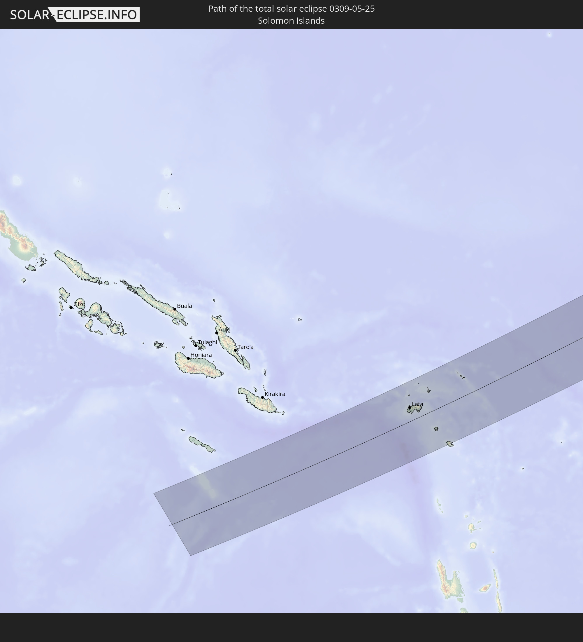 Solomon Islands
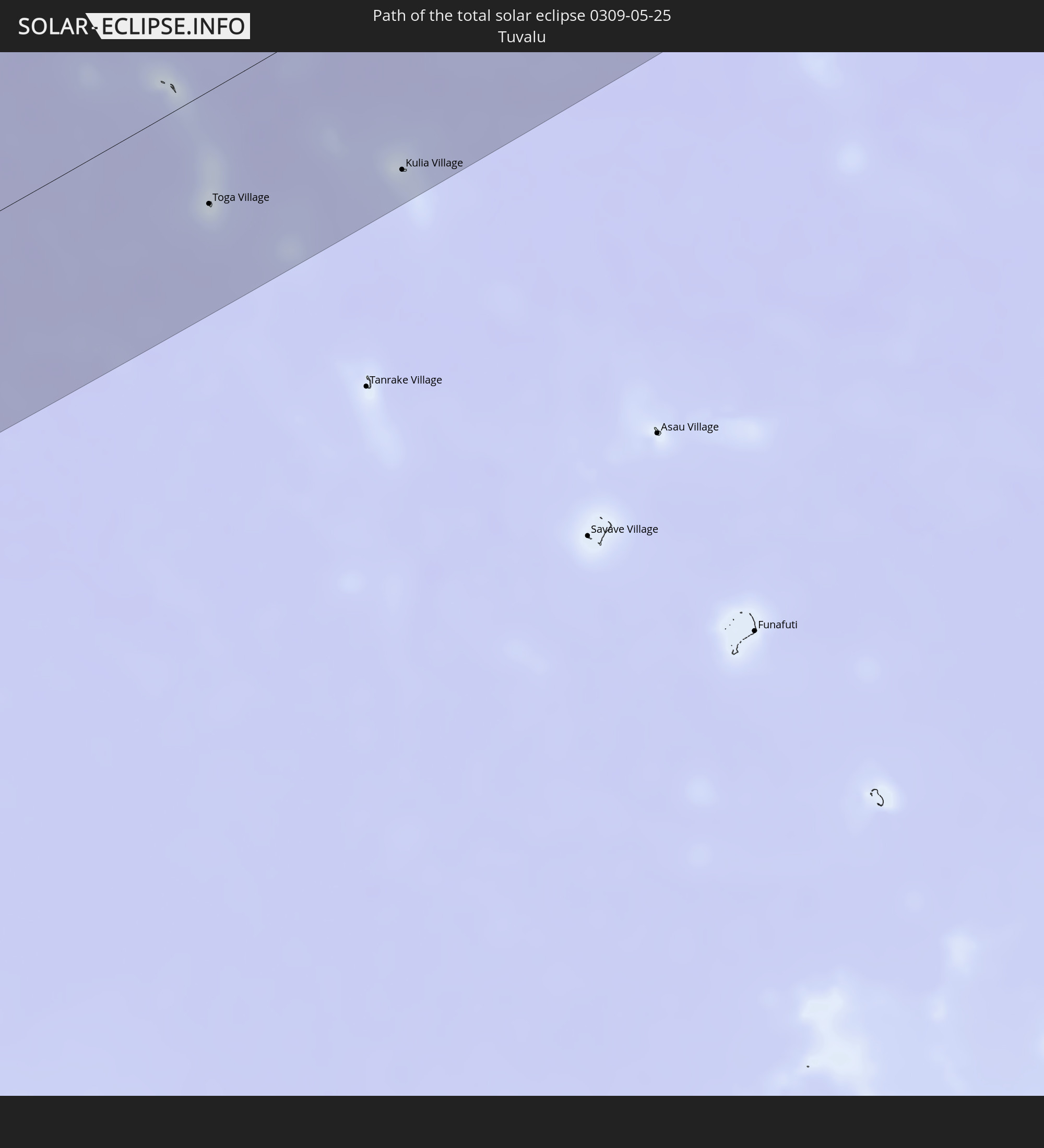 Tuvalu
In den folgenden Ländern ist die Sonnenfinsternis partiell zu sehen
 Fiji
Fiji
 United States
 New Zealand
 United States Minor Outlying Islands
 Wallis and Futuna
 Tonga
Tonga
 Kiribati
 Samoa
Samoa
 Tokelau
 American Samoa
 Niue
Niue
 Cook Islands
 French Polynesia
 Canada
 Mexico
 Greenland
 Guatemala
 Ecuador
 El Salvador
 Honduras
 Belize
 Nicaragua
 Costa Rica
 Cuba
Cuba
 Panama
 Colombia
 Cayman Islands
 Peru
Peru
 The Bahamas
 Jamaica
 Haiti
Haiti
 Turks and Caicos Islands
 Dominican Republic
 Bermuda
 Saint Pierre and Miquelon
 Federated States of Micronesia
 Papua New Guinea
 Guam
Guam
 Northern Mariana Islands
 Solomon Islands
 New Caledonia
 Marshall Islands
 Vanuatu
 Nauru
Nauru
 Norfolk Island
 Tuvalu
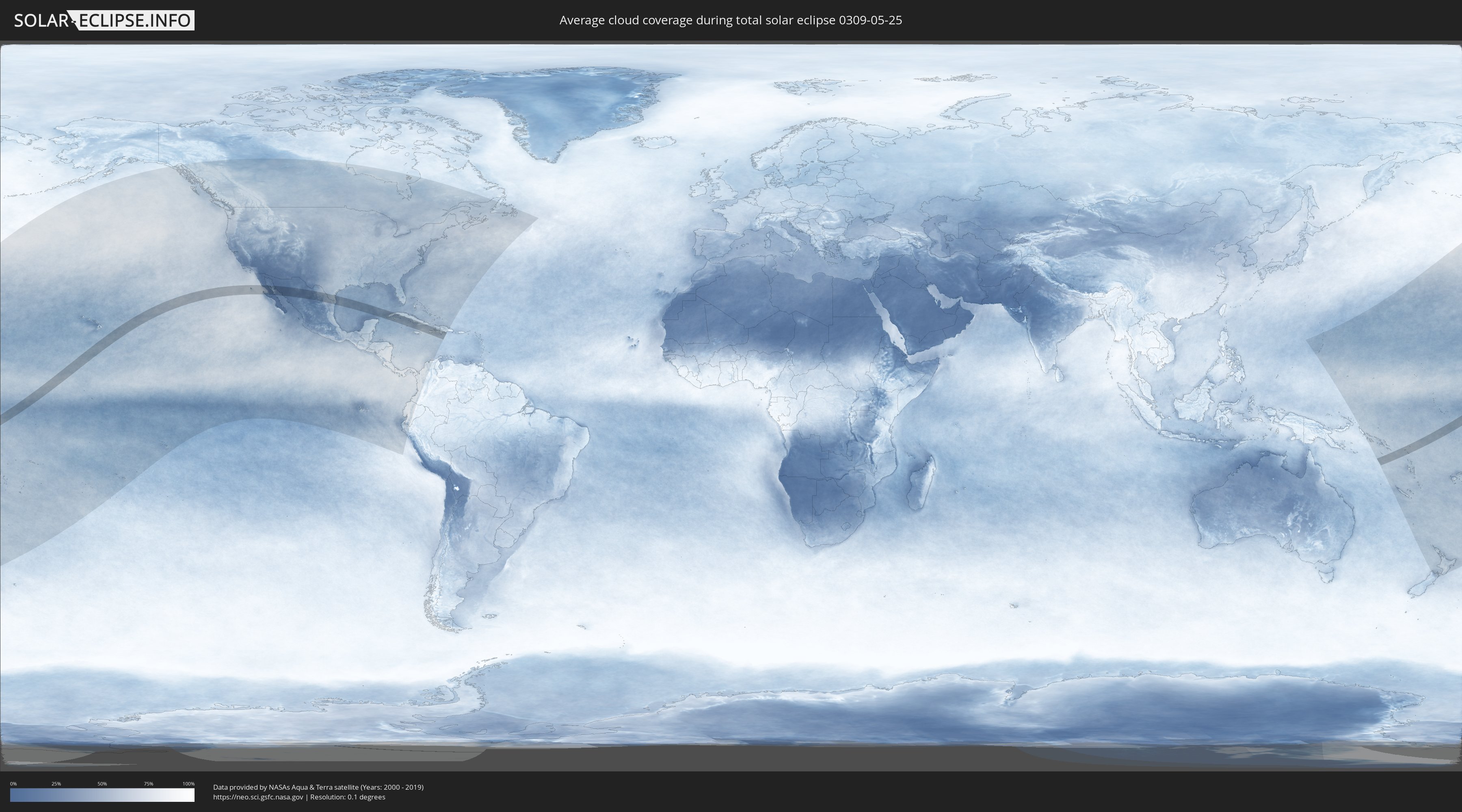
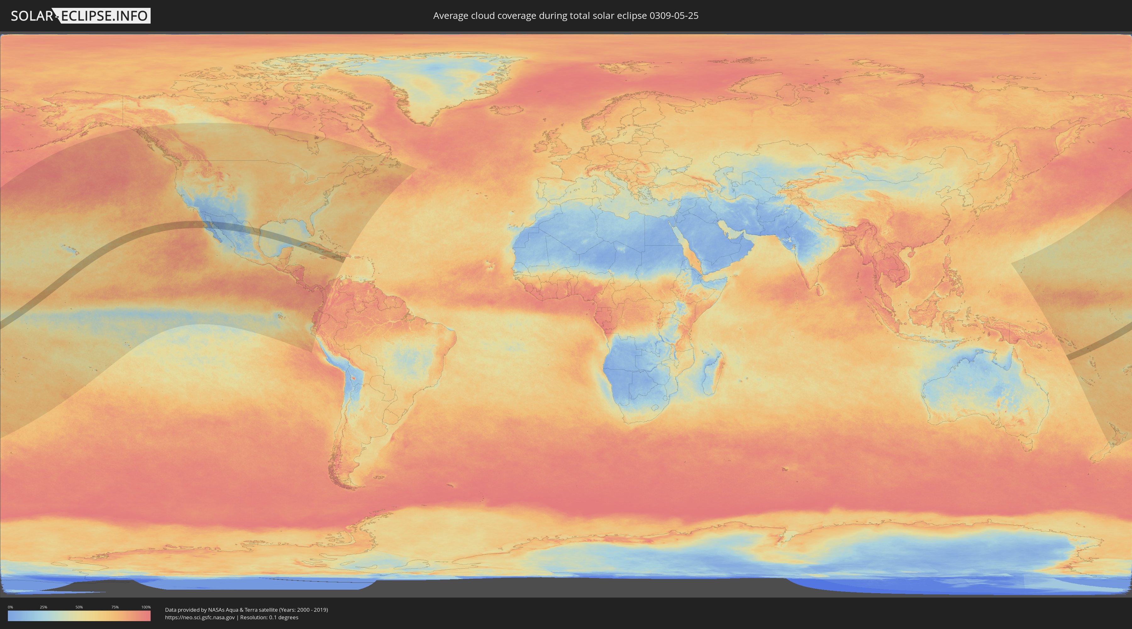
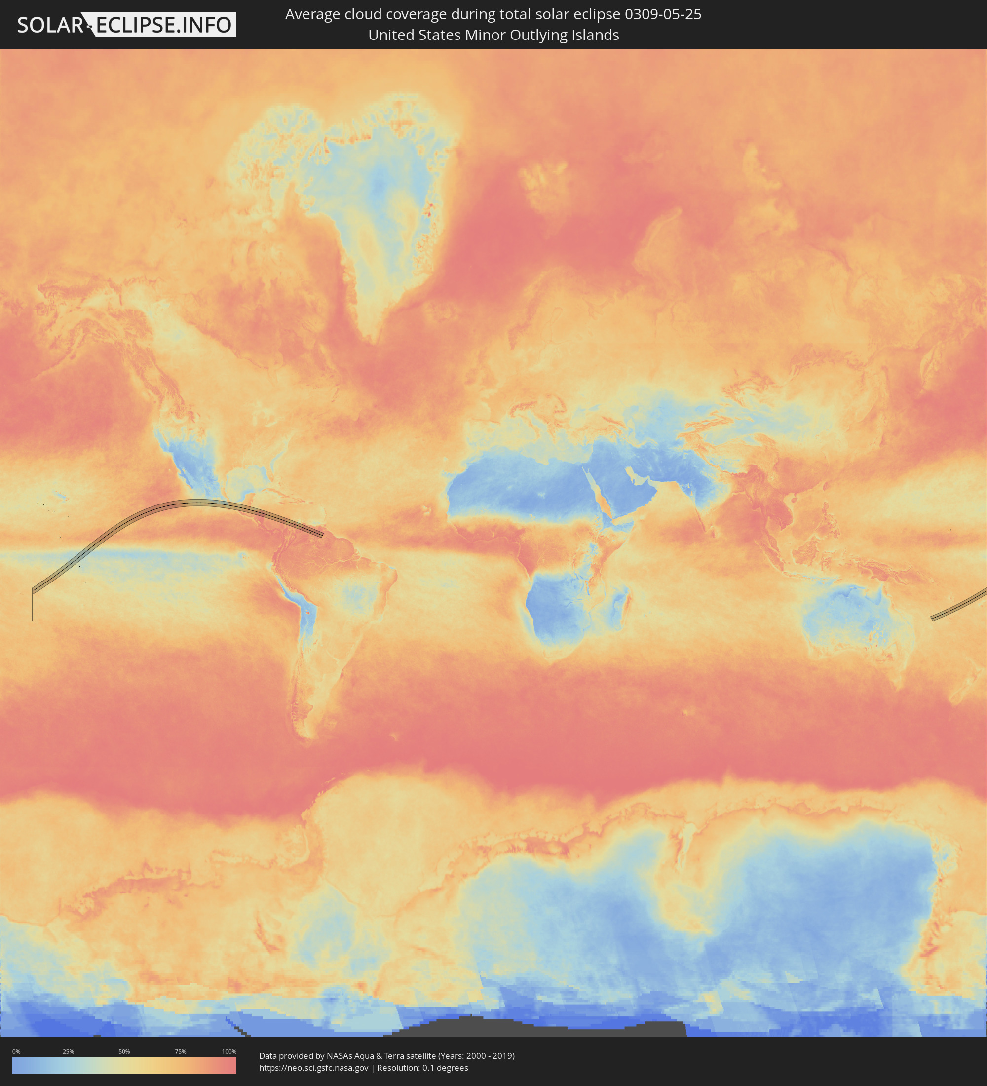
How will be the weather during the total solar eclipse on 05/25/0309?
Where is the best place to see the total solar eclipse of 05/25/0309?
The following maps show the average cloud coverage for the day of the total solar eclipse.
With the help of these maps, it is possible to find the place along the eclipse path, which has the best
chance of a cloudless sky.
Nevertheless, you should consider local circumstances and inform about the weather of your chosen
observation site.
The data is provided by NASAs satellites
AQUA and TERRA.
The cloud maps are averaged over a period of 19 years (2000 - 2019).
Detailed country maps
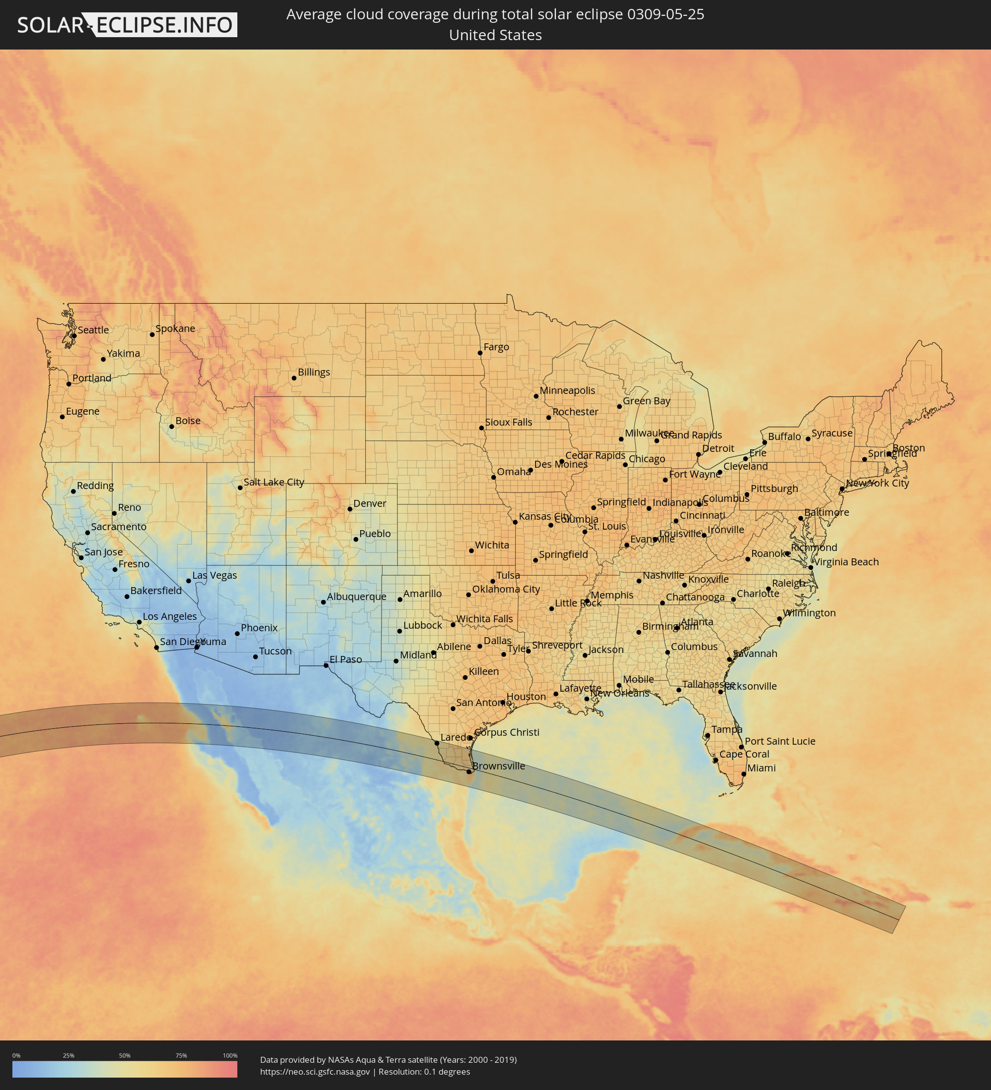 United States
 United States Minor Outlying Islands
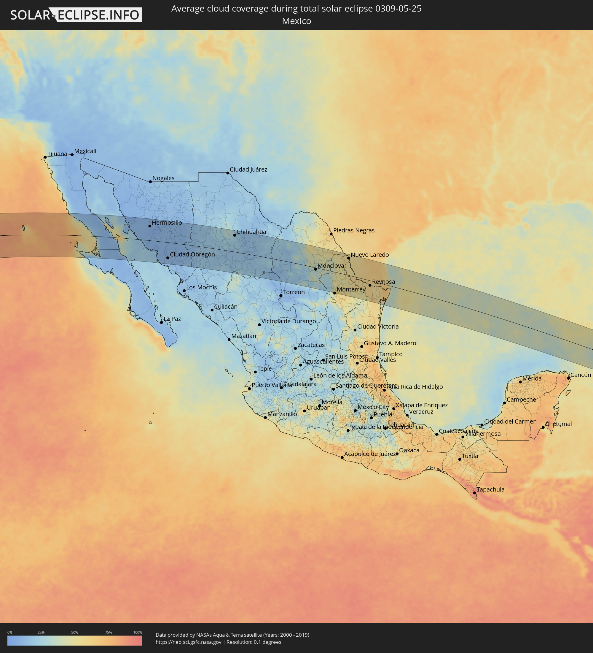 Mexico
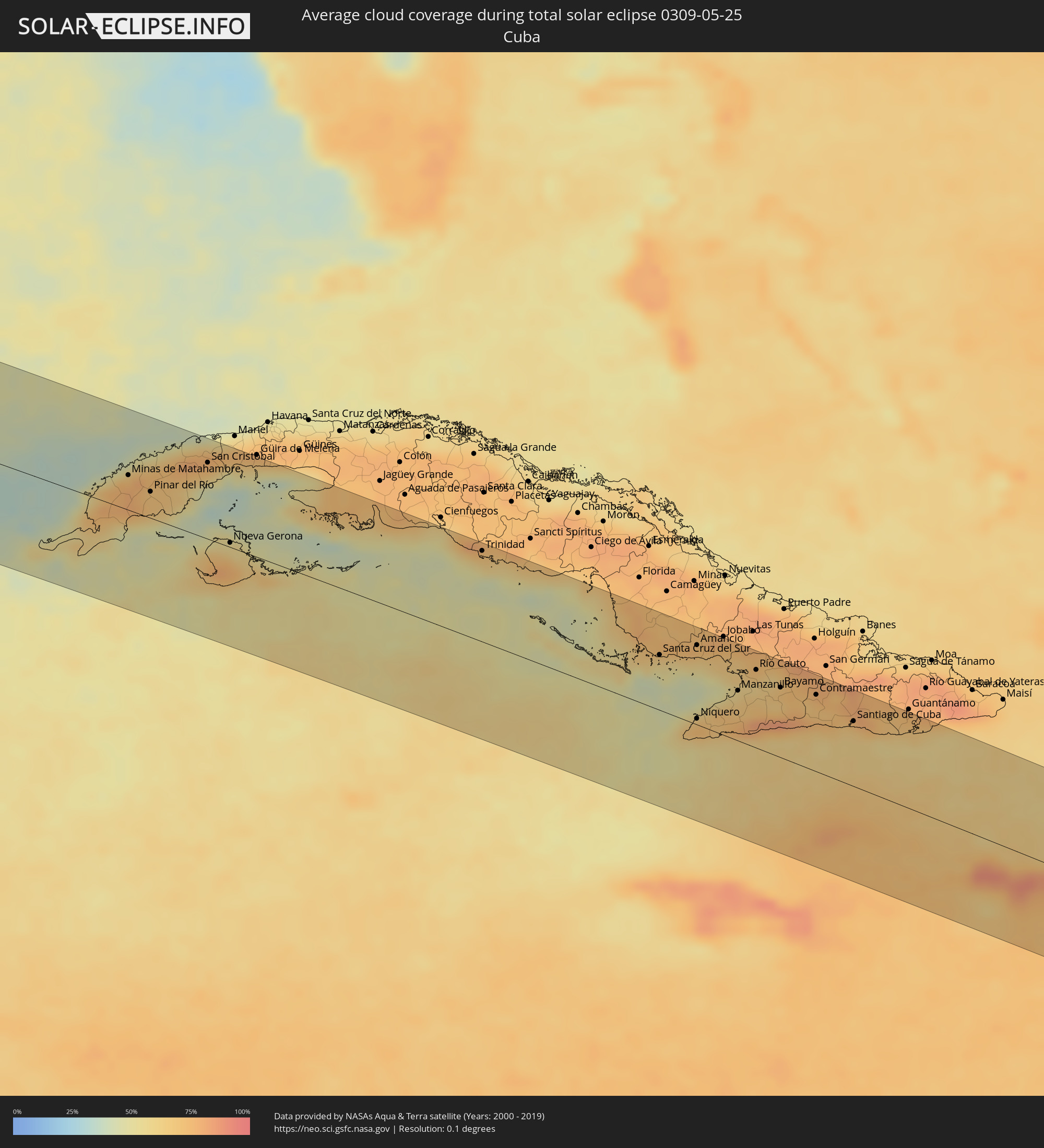 Cuba
Cuba
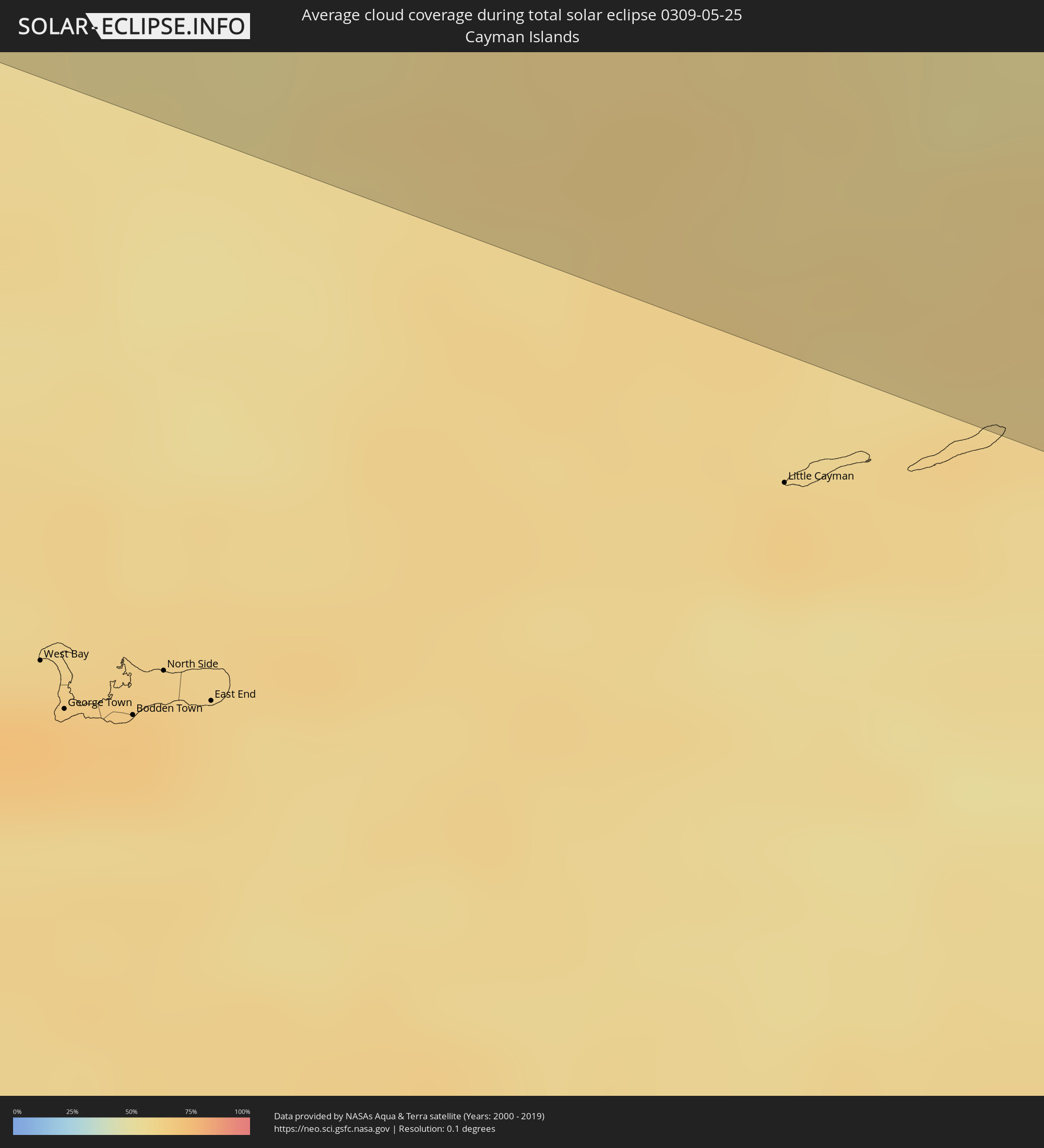 Cayman Islands
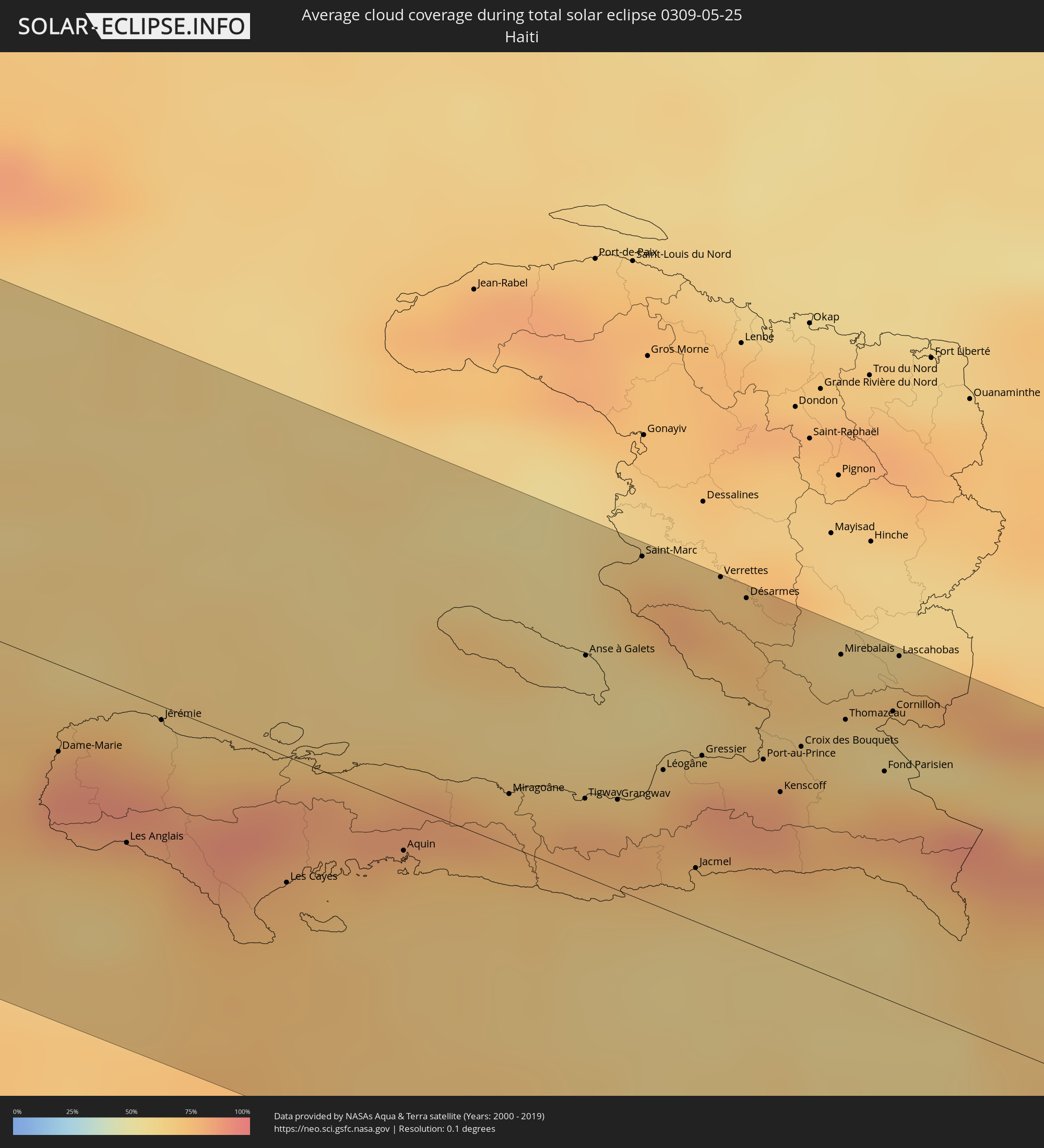 Haiti
Haiti
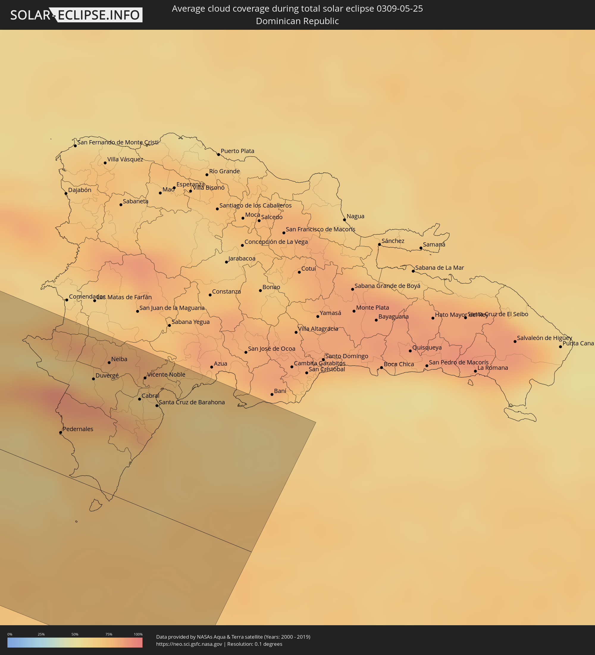 Dominican Republic
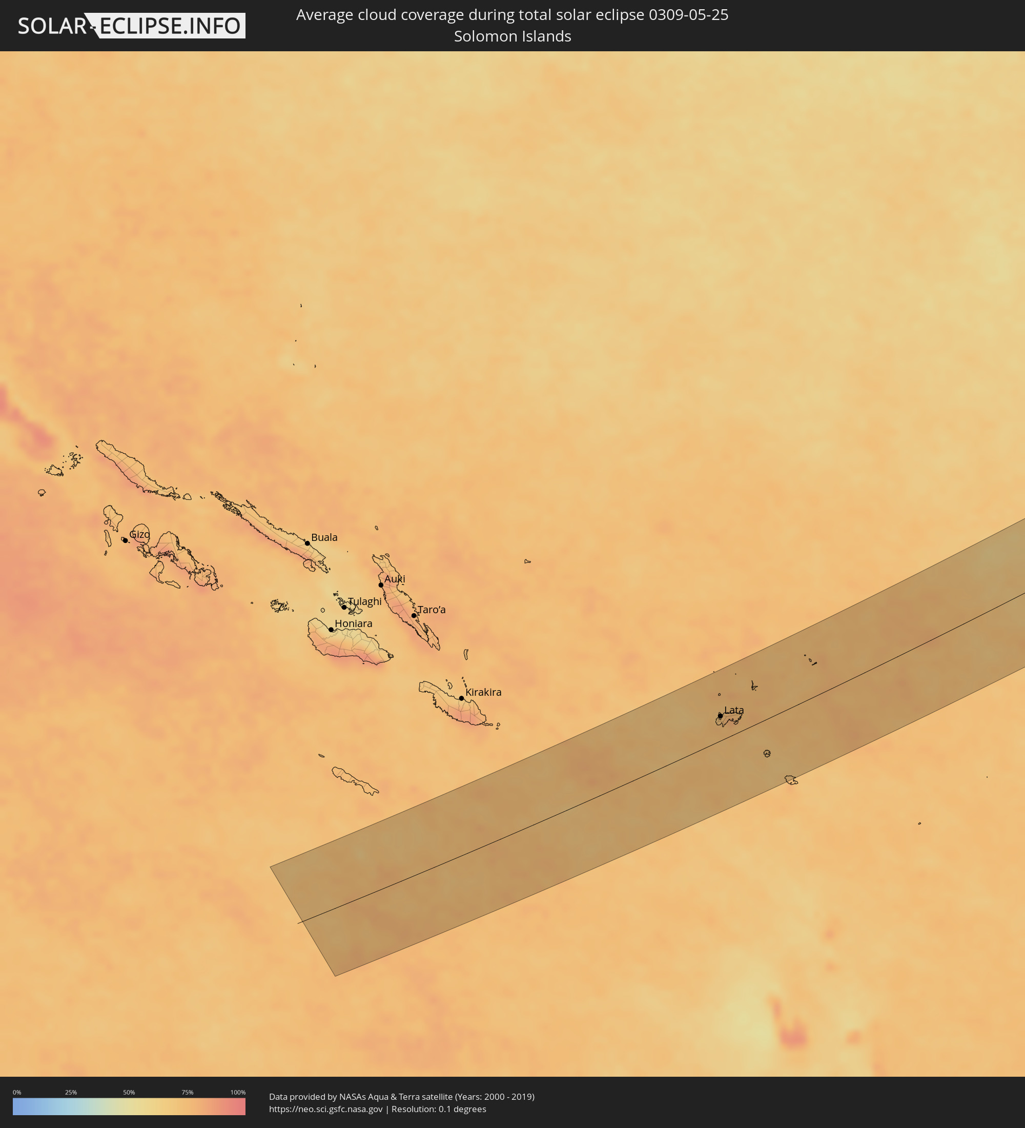 Solomon Islands
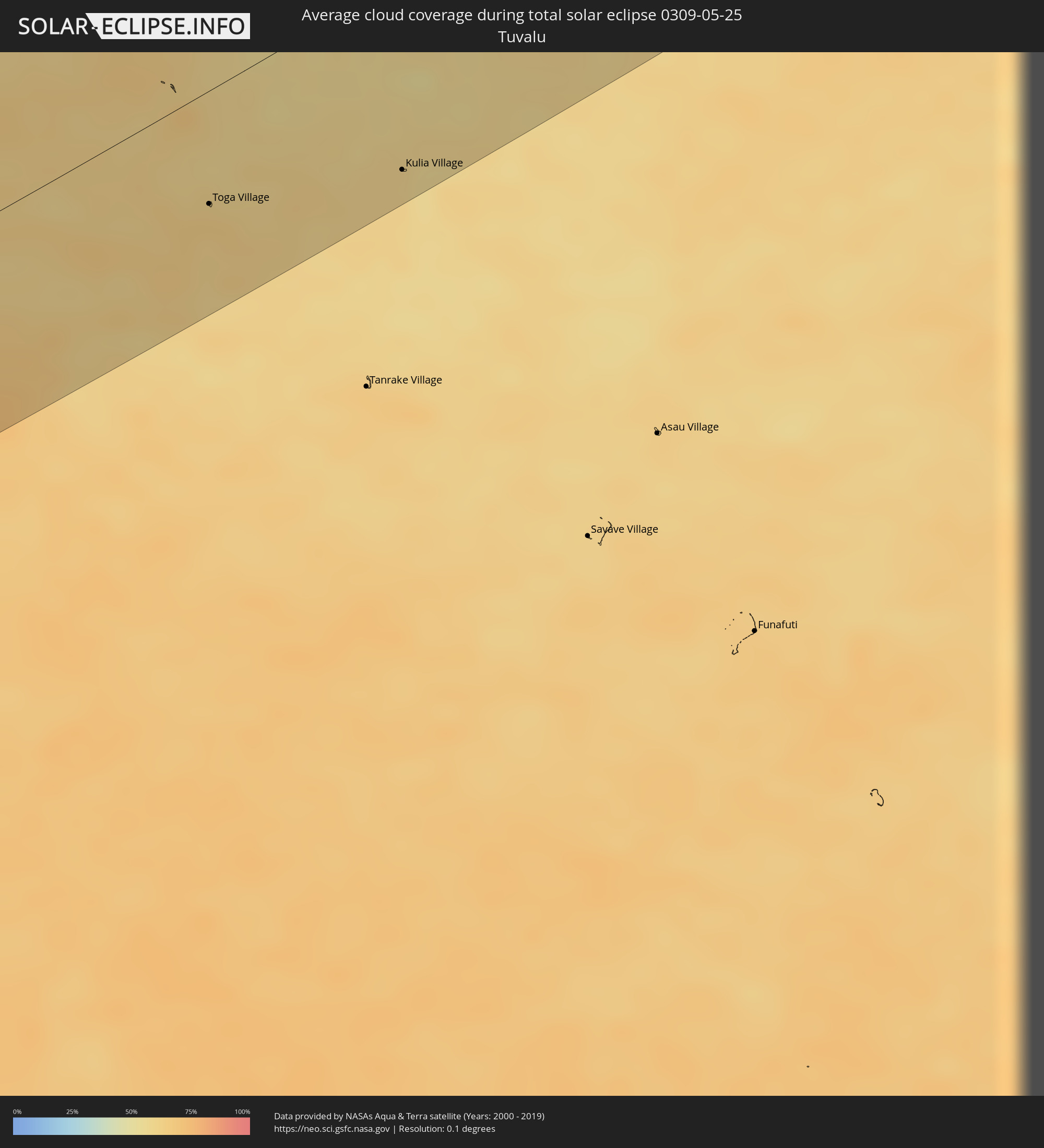 Tuvalu
Cities inside the path of the eclipse
The following table shows all locations with a population of more than 5,000 inside the eclipse path. Cities which have more than 100,000 inhabitants are marked bold. A click at the locations opens a detailed map.
| City | Type | Eclipse duration | Local time of max. eclipse | Distance to central line | Ø Cloud coverage |
|
Miguel Alemán (La Doce), Sonora
|
total | - | 15:07:27 UTC-07:23 | 45 km | 9% |
|
Hermosillo, Sonora
|
total | - | 15:08:08 UTC-07:23 | 79 km | 6% |
|
Heroica Guaymas, Sonora
|
total | - | 15:08:36 UTC-07:23 | 51 km | 21% |
|
Pueblo Yaqui, Sonora
|
total | - | 15:10:06 UTC-07:23 | 104 km | 11% |
|
Ciudad Obregón, Sonora
|
total | - | 15:10:12 UTC-07:23 | 89 km | 8% |
|
Cuauhtémoc, Chihuahua
|
total | - | 15:32:29 UTC-07:05 | 54 km | 20% |
|
Chihuahua, Chihuahua
|
total | - | 15:33:24 UTC-07:05 | 91 km | 21% |
|
Santa Bárbara, Chihuahua
|
total | - | 15:34:30 UTC-07:05 | 106 km | 29% |
|
Hidalgo del Parral, Chihuahua
|
total | - | 15:34:39 UTC-07:05 | 90 km | 22% |
|
Ciudad Delicias, Chihuahua
|
total | - | 15:34:23 UTC-07:05 | 52 km | 13% |
|
Jiménez, Chihuahua
|
total | - | 15:34:25 UTC-07:05 | 69 km | 13% |
|
Ciudad Camargo, Chihuahua
|
total | - | 15:34:59 UTC-07:05 | 1 km | 15% |
|
San Buenaventura, Coahuila
|
total | - | 16:08:35 UTC-06:36 | 4 km | 36% |
|
Melchor Múzquiz, Coahuila
|
total | - | 16:08:13 UTC-06:36 | 93 km | 51% |
|
Monclova, Coahuila
|
total | - | 16:08:48 UTC-06:36 | 10 km | 32% |
|
Ciudad Sabinas, Coahuila
|
total | - | 16:08:40 UTC-06:36 | 99 km | 48% |
|
García, Nuevo León
|
total | - | 16:10:11 UTC-06:36 | 111 km | 36% |
|
San Nicolás de los Garza, Nuevo León
|
total | - | 16:10:32 UTC-06:36 | 112 km | 48% |
|
Sabinas Hidalgo, Nuevo León
|
total | - | 16:10:18 UTC-06:36 | 27 km | 50% |
|
Fraccionamiento Real Palmas, Nuevo León
|
total | - | 16:10:36 UTC-06:36 | 91 km | 52% |
|
Ciudad Anáhuac, Nuevo León
|
total | - | 16:09:59 UTC-06:36 | 55 km | 50% |
|
Hidalgo, Nuevo León
|
total | - | 16:11:11 UTC-06:36 | 83 km | 54% |
|
Nuevo Laredo, Tamaulipas
|
total | - | 16:10:29 UTC-06:36 | 94 km | 53% |
|
Laredo, Texas
|
total | - | 16:47:04 UTC-06:00 | 98 km | 53% |
|
Ciudad Miguel Alemán, Tamaulipas
|
total | - | 16:11:30 UTC-06:36 | 11 km | 56% |
|
Roma-Los Saenz, Texas
|
total | - | 16:48:07 UTC-06:00 | 10 km | 56% |
|
Rio Grande City, Texas
|
total | - | 16:48:19 UTC-06:00 | 8 km | 54% |
|
Ciudad Díaz Ordaz, Tamaulipas
|
total | - | 16:12:00 UTC-06:36 | 19 km | 54% |
|
Perezville, Texas
|
total | - | 16:48:47 UTC-06:00 | 15 km | 54% |
|
Palmview South, Texas
|
total | - | 16:48:49 UTC-06:00 | 15 km | 54% |
|
Palmview, Texas
|
total | - | 16:48:49 UTC-06:00 | 13 km | 54% |
|
La Homa, Texas
|
total | - | 16:48:48 UTC-06:00 | 11 km | 57% |
|
Alton, Texas
|
total | - | 16:48:50 UTC-06:00 | 6 km | 59% |
|
Alton North (historical), Texas
|
total | - | 16:48:50 UTC-06:00 | 5 km | 59% |
|
Reynosa, Tamaulipas
|
total | - | 16:12:22 UTC-06:36 | 27 km | 61% |
|
Hidalgo, Texas
|
total | - | 16:48:59 UTC-06:00 | 25 km | 61% |
|
McAllen, Texas
|
total | - | 16:48:57 UTC-06:00 | 13 km | 60% |
|
San Juan, Texas
|
total | - | 16:49:02 UTC-06:00 | 12 km | 60% |
|
Alamo, Texas
|
total | - | 16:49:04 UTC-06:00 | 12 km | 58% |
|
Nurillo, Texas
|
total | - | 16:49:02 UTC-06:00 | 3 km | 58% |
|
Murillo Colonia, Texas
|
total | - | 16:49:02 UTC-06:00 | 4 km | 58% |
|
Río Bravo, Tamaulipas
|
total | - | 16:12:35 UTC-06:36 | 33 km | 55% |
|
Donna, Texas
|
total | - | 16:49:08 UTC-06:00 | 12 km | 58% |
|
Elsa, Texas
|
total | - | 16:49:08 UTC-06:00 | 3 km | 60% |
|
Weslaco, Texas
|
total | - | 16:49:12 UTC-06:00 | 11 km | 60% |
|
Mila Doce, Texas
|
total | - | 16:49:12 UTC-06:00 | 3 km | 60% |
|
Progreso, Texas
|
total | - | 16:49:16 UTC-06:00 | 18 km | 56% |
|
Mercedes, Texas
|
total | - | 16:49:17 UTC-06:00 | 11 km | 56% |
|
La Feria, Texas
|
total | - | 16:49:21 UTC-06:00 | 7 km | 59% |
|
Valle Hermoso, Tamaulipas
|
total | - | 16:13:00 UTC-06:36 | 60 km | 55% |
|
Raymondville, Texas
|
total | - | 16:49:14 UTC-06:00 | 28 km | 62% |
|
Harlingen, Texas
|
total | - | 16:49:27 UTC-06:00 | 1 km | 62% |
|
San Benito, Texas
|
total | - | 16:49:33 UTC-06:00 | 5 km | 65% |
|
Heroica Matamoros, Tamaulipas
|
total | - | 16:13:11 UTC-06:36 | 29 km | 68% |
|
Brownsville, Texas
|
total | - | 16:49:47 UTC-06:00 | 27 km | 68% |
|
Cameron Park Colonia, Texas
|
total | - | 16:49:46 UTC-06:00 | 19 km | 67% |
|
Cameron Park, Texas
|
total | - | 16:49:46 UTC-06:00 | 20 km | 67% |
|
Los Fresnos, Texas
|
total | - | 16:49:43 UTC-06:00 | 8 km | 68% |
|
Guane, Pinar del Río
|
total | - | 17:30:09 UTC-05:29 | 8 km | 61% |
|
Minas de Matahambre, Pinar del Río
|
total | - | 17:30:01 UTC-05:29 | 38 km | 74% |
|
Viñales, Pinar del Río
|
total | - | 17:30:05 UTC-05:29 | 49 km | 74% |
|
Pinar del Río, Pinar del Río
|
total | - | 17:30:11 UTC-05:29 | 29 km | 71% |
|
Consolación del Sur, Pinar del Río
|
total | - | 17:30:12 UTC-05:29 | 44 km | 70% |
|
Los Palacios, Pinar del Río
|
total | - | 17:30:14 UTC-05:29 | 62 km | 67% |
|
Bahía Honda, Artemisa
|
total | - | 17:30:07 UTC-05:29 | 98 km | 74% |
|
San Cristobal, Artemisa
|
total | - | 17:30:14 UTC-05:29 | 83 km | 72% |
|
Nueva Gerona, Isla de la Juventud
|
total | - | 17:30:42 UTC-05:29 | 5 km | 63% |
|
Artemisa, Artemisa
|
total | - | 17:30:16 UTC-05:29 | 104 km | 69% |
|
Alquízar, Artemisa
|
total | - | 17:30:19 UTC-05:29 | 109 km | 68% |
|
Trinidad, Sancti Spíritus
|
total | - | 17:31:23 UTC-05:29 | 99 km | 61% |
|
Santa Cruz del Sur, Camagüey
|
total | - | 17:32:10 UTC-05:29 | 60 km | 53% |
|
Niquero, Granma
|
total | - | 17:32:29 UTC-05:29 | 6 km | 72% |
|
Amancio, Las Tunas
|
total | - | 17:32:10 UTC-05:29 | 87 km | 64% |
|
Media Luna, Granma
|
total | - | 17:32:28 UTC-05:29 | 22 km | 69% |
|
Campechuela, Granma
|
total | - | 17:32:26 UTC-05:29 | 37 km | 71% |
|
Manzanillo, Granma
|
total | - | 17:32:25 UTC-05:29 | 55 km | 66% |
|
Yara, Granma
|
total | - | 17:32:27 UTC-05:29 | 54 km | 68% |
|
Bartolomé Masó, Granma
|
total | - | 17:32:30 UTC-05:29 | 43 km | 72% |
|
Río Cauto, Granma
|
total | - | 17:32:20 UTC-05:29 | 85 km | 68% |
|
Bayamo, Granma
|
total | - | 17:32:26 UTC-05:29 | 76 km | 70% |
|
Guisa, Granma
|
total | - | 17:32:29 UTC-05:29 | 68 km | 71% |
|
Cauto Cristo, Granma
|
total | - | 17:32:22 UTC-05:29 | 102 km | 73% |
|
Jiguaní, Granma
|
total | - | 17:32:27 UTC-05:29 | 84 km | 72% |
|
Contramaestre, Santiago de Cuba
|
total | - | 17:32:29 UTC-05:29 | 84 km | 72% |
|
Palma Soriano, Santiago de Cuba
|
total | - | 17:32:32 UTC-05:29 | 84 km | 71% |
|
San Luis, Santiago de Cuba
|
total | - | 17:32:33 UTC-05:29 | 87 km | 75% |
|
Santiago de Cuba, Santiago de Cuba
|
total | - | 17:32:37 UTC-05:29 | 71 km | 65% |
|
Dame-Marie, GrandʼAnse
|
total | - | 18:13:48 UTC-04:49 | 25 km | 82% |
|
Les Anglais, Sud
|
total | - | 18:13:54 UTC-04:49 | 44 km | 72% |
|
Jérémie, GrandʼAnse
|
total | - | 18:13:46 UTC-04:49 | 4 km | 66% |
|
Les Cayes, Sud
|
total | - | 18:13:55 UTC-04:49 | 37 km | 75% |
|
Aquin, Sud
|
total | - | 18:13:53 UTC-04:49 | 14 km | 75% |
|
Miragoâne, Nippes
|
total | - | 18:13:49 UTC-04:49 | 15 km | 79% |
|
Tigwav, Ouest
|
total | - | 18:13:48 UTC-04:49 | 23 km | 80% |
|
Anse à Galets, Ouest
|
total | - | 18:13:40 UTC-04:49 | 64 km | 58% |
|
Grangwav, Ouest
|
total | - | 18:13:48 UTC-04:49 | 26 km | 79% |
|
Saint-Marc, Artibonite
|
total | - | 18:13:33 UTC-04:49 | 99 km | 77% |
|
Léogâne, Ouest
|
total | - | 18:13:46 UTC-04:49 | 40 km | 78% |
|
Jacmel, Sud-Est
|
total | - | 18:13:51 UTC-04:49 | 16 km | 65% |
|
Gressier, Ouest
|
total | - | 18:13:45 UTC-04:49 | 49 km | 70% |
|
Verrettes, Artibonite
|
total | - | 18:13:34 UTC-04:49 | 103 km | 70% |
|
Carrefour, Ouest
|
total | - | 18:13:44 UTC-04:49 | 53 km | 83% |
|
Désarmes, Artibonite
|
total | - | 18:13:35 UTC-04:49 | 100 km | 71% |
|
Port-au-Prince, Ouest
|
total | - | 18:13:44 UTC-04:49 | 55 km | 82% |
|
Delmas 73, Ouest
|
total | - | 18:13:44 UTC-04:49 | 57 km | 82% |
|
Pétionville, Ouest
|
total | - | 18:13:45 UTC-04:49 | 54 km | 82% |
|
Kenscoff, Ouest
|
total | - | 18:13:46 UTC-04:49 | 48 km | 84% |
|
Croix des Bouquets, Ouest
|
total | - | 18:13:43 UTC-04:49 | 63 km | 67% |
|
Mirebalais, Centre
|
total | - | 18:13:37 UTC-04:49 | 94 km | 67% |
|
Thomazeau, Ouest
|
total | - | 18:13:41 UTC-04:49 | 76 km | 61% |
|
Fond Parisien, Ouest
|
total | - | 18:13:43 UTC-04:49 | 66 km | 76% |
|
Cornillon, Ouest
|
total | - | 18:13:40 UTC-04:49 | 84 km | 62% |
|
Lascahobas, Centre
|
total | - | 18:13:36 UTC-04:49 | 101 km | 74% |
|
Jimaní, Independencia
|
total | - | 18:22:43 UTC-04:40 | 69 km | 75% |
|
Pedernales, Pedernales
|
total | - | 18:22:52 UTC-04:40 | 27 km | 68% |
|
La Descubierta, Independencia
|
total | - | 18:22:41 UTC-04:40 | 82 km | 65% |
|
Duvergé, Independencia
|
total | - | 18:22:44 UTC-04:40 | 71 km | 71% |
|
Villa Jaragua, Baoruco
|
total | - | 18:22:41 UTC-04:40 | 84 km | 67% |
|
Neiba, Baoruco
|
total | - | 18:22:41 UTC-04:40 | 86 km | 71% |
|
Galván, Baoruco
|
total | - | 18:22:40 UTC-04:40 | 91 km | 74% |
|
Enriquillo, Barahona
|
total | - | 18:22:52 UTC-04:40 | 33 km | 67% |
|
Cabral, Barahona
|
total | - | 18:22:45 UTC-04:40 | 70 km | 64% |
|
Tamayo, Baoruco
|
total | - | 18:22:42 UTC-04:40 | 85 km | 66% |
|
Vicente Noble, Barahona
|
total | - | 18:22:42 UTC-04:40 | 85 km | 66% |
|
Paraíso, Barahona
|
total | - | 18:22:50 UTC-04:40 | 45 km | 70% |
|
Santa Cruz de Barahona, Barahona
|
total | - | 18:22:45 UTC-04:40 | 70 km | 72% |
|
Lata, Temotu
|
total | - | 06:18:10 UTC+10:39 | 36 km | 70% |
|
Toga Village, Nanumanga
|
total | - | 07:43:07 UTC+12:00 | 57 km | 63% |
|
Kulia Village, Niutao
|
total | - | 07:43:39 UTC+12:00 | 97 km | 60% |