Total solar eclipse of 07/08/0400
| Day of week: | Saturday |
| Maximum duration of eclipse: | 04m00s |
| Maximum width of eclipse path: | 183 km |
| Saros cycle: | 91 |
| Coverage: | 100% |
| Magnitude: | 1.0502 |
| Gamma: | 0.4163 |
Wo kann man die Sonnenfinsternis vom 07/08/0400 sehen?
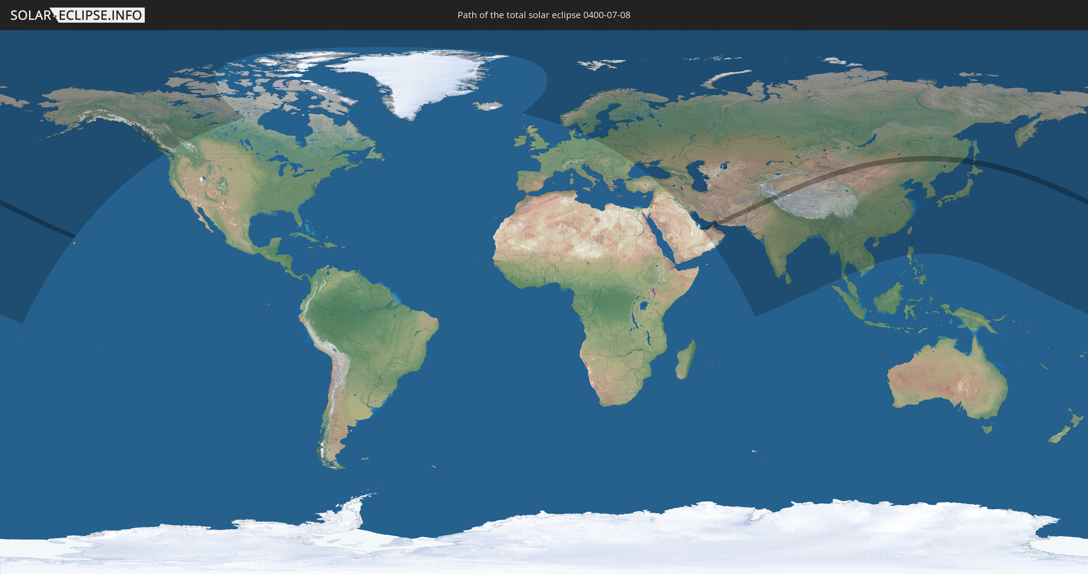
Die Sonnenfinsternis am 07/08/0400 kann man in 65 Ländern als partielle Sonnenfinsternis beobachten.
Der Finsternispfad verläuft durch 9 Länder. Nur in diesen Ländern ist sie als total Sonnenfinsternis zu sehen.
In den folgenden Ländern ist die Sonnenfinsternis total zu sehen
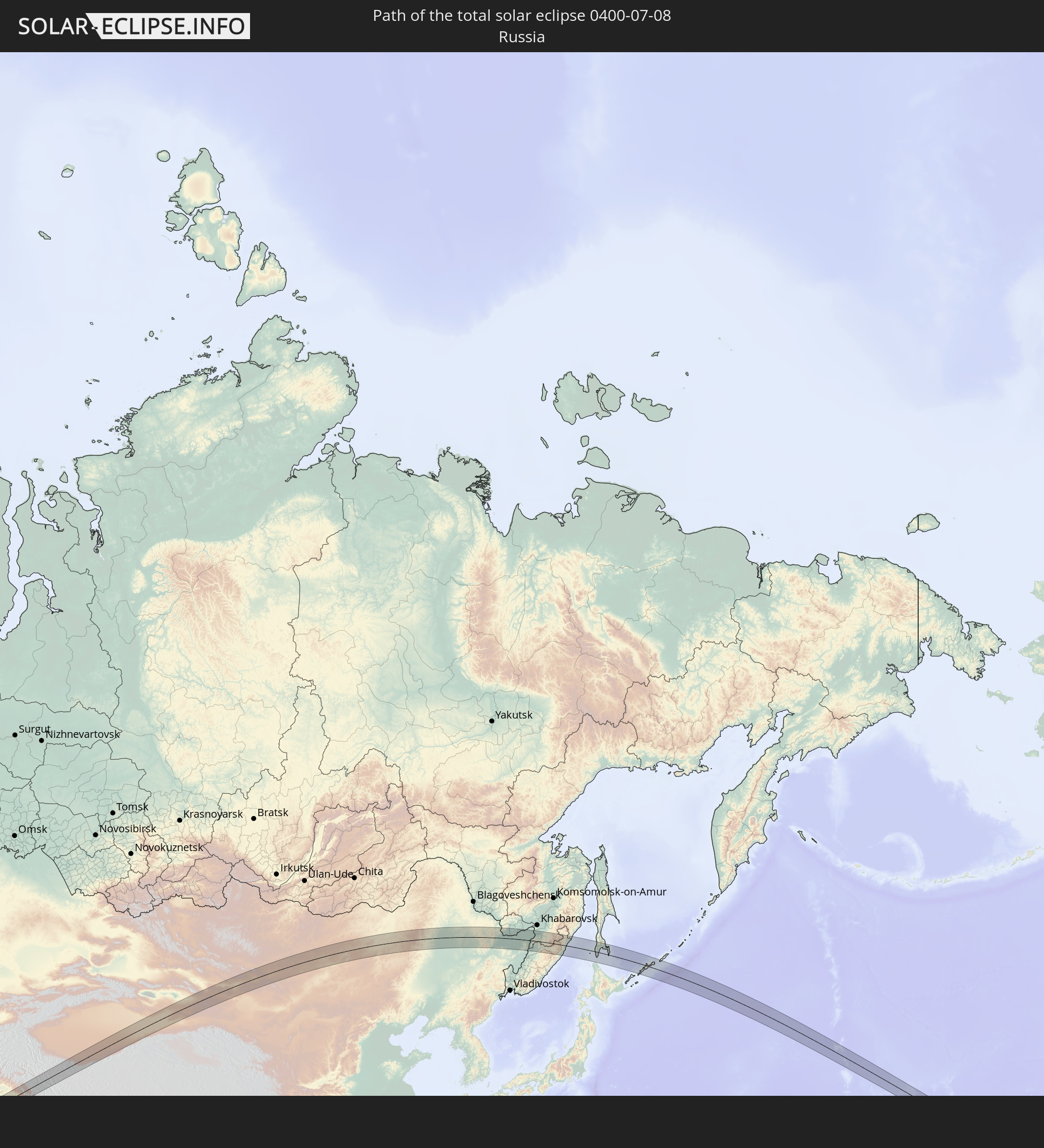 Russia
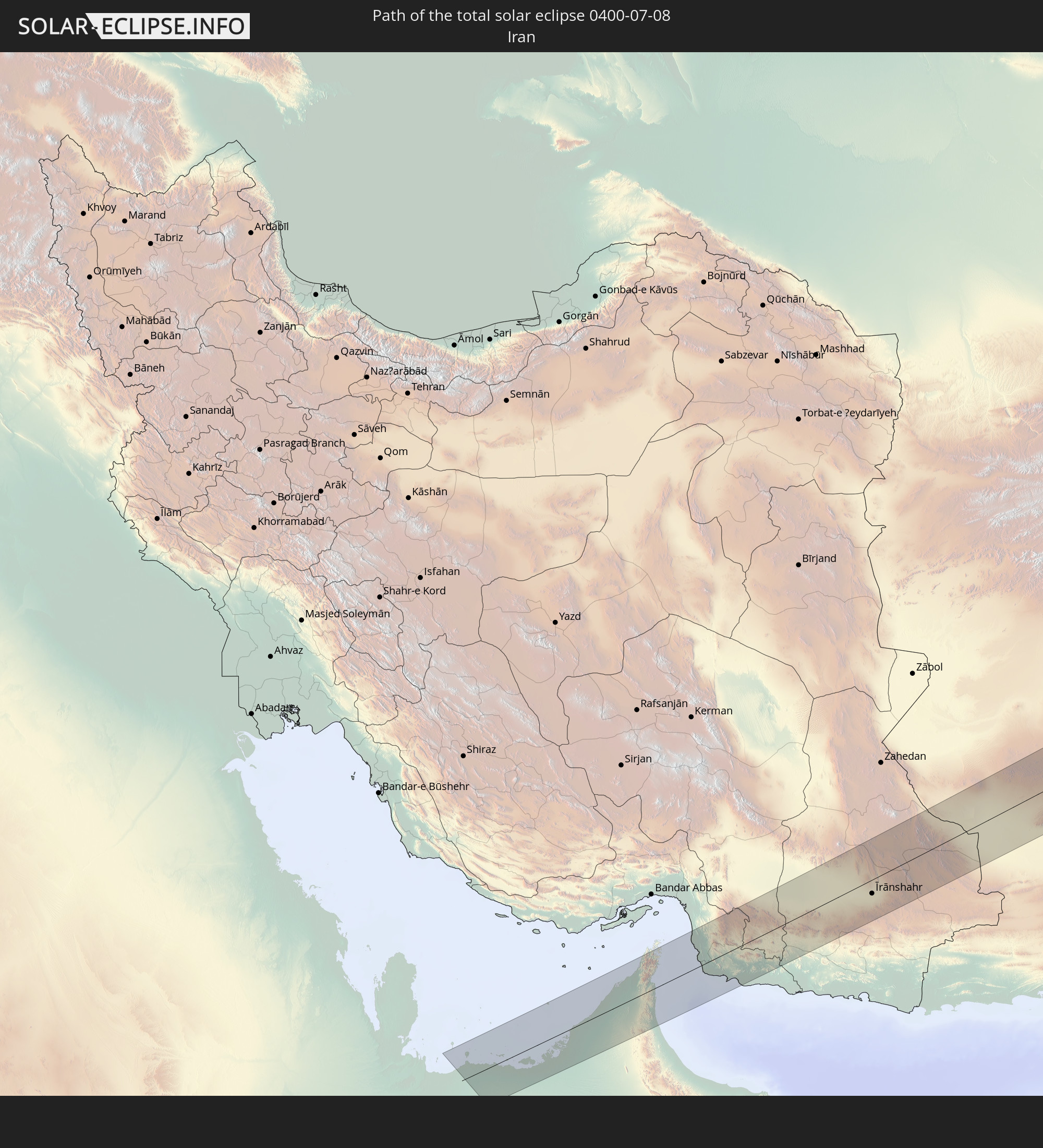 Iran
Iran
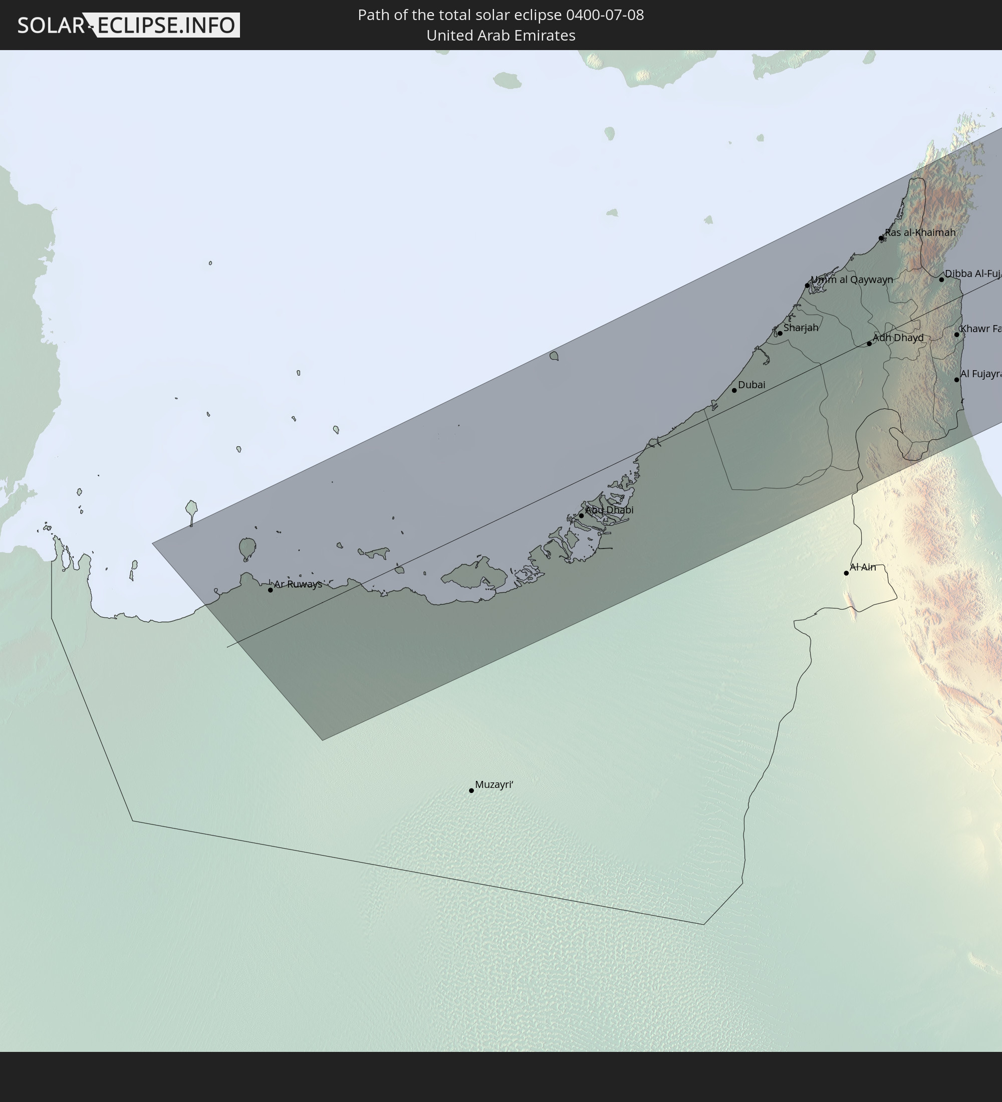 United Arab Emirates
 Oman
Oman
 Afghanistan
 Pakistan
 India
India
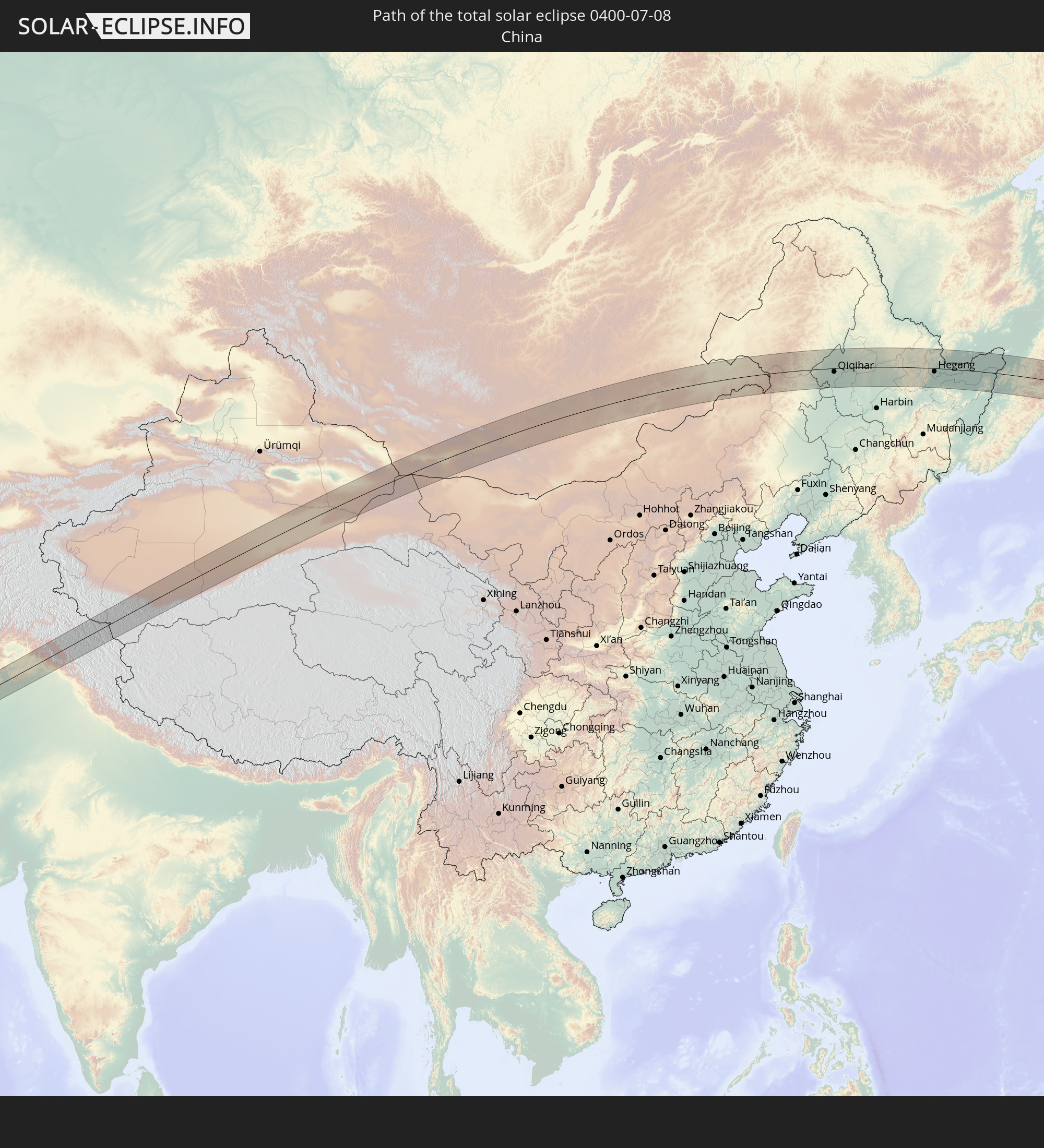 China
China
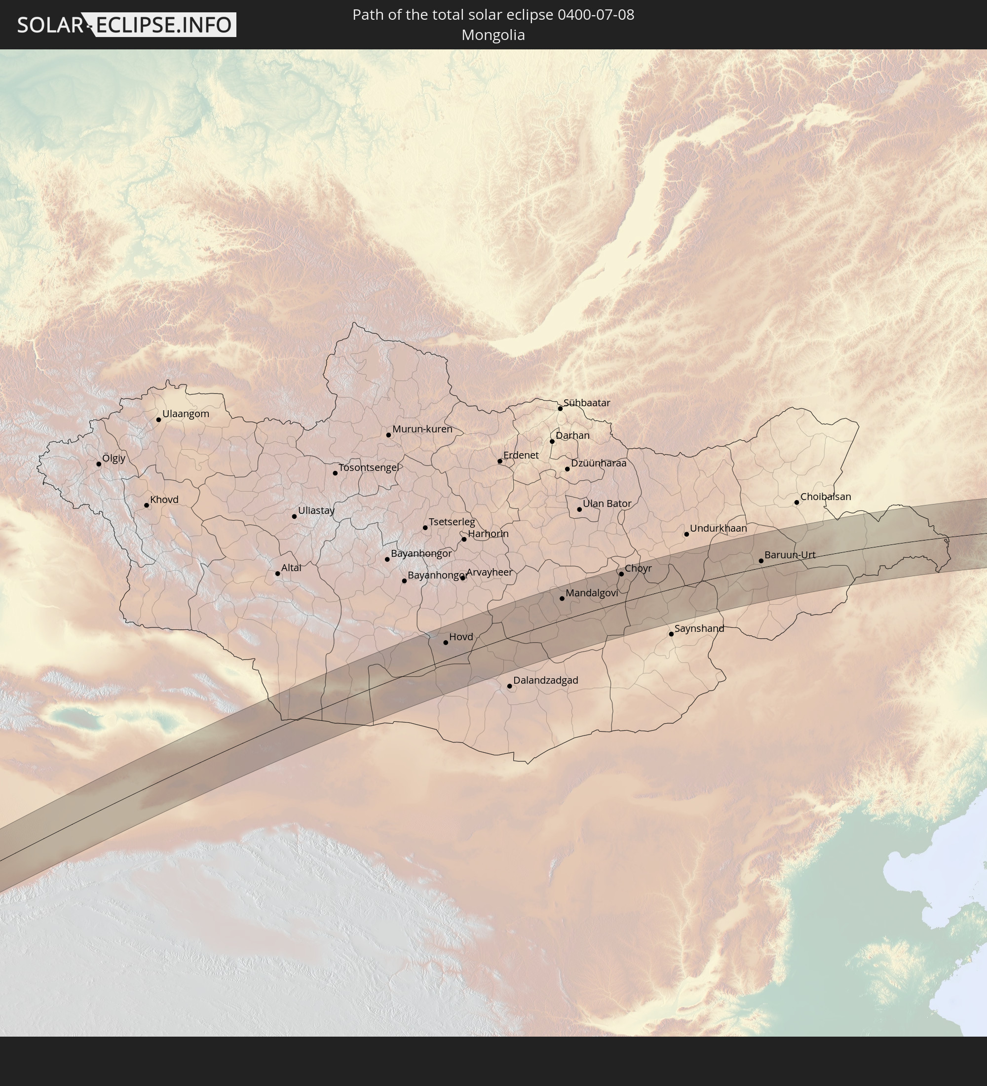 Mongolia
In den folgenden Ländern ist die Sonnenfinsternis partiell zu sehen
 Russia
 United States
 United States Minor Outlying Islands
 Kiribati
 Canada
 Svalbard and Jan Mayen
 United Kingdom
 Faroe Islands
 Norway
 Denmark
 Sweden
 Poland
 Åland Islands
 Romania
 Finland
 Lithuania
 Latvia
 Estonia
 Ukraine
 Belarus
 Turkey
 Moldova
 Saudi Arabia
 Syria
Syria
 Iraq
Iraq
 Georgia
 Armenia
 Iran
Iran
 Azerbaijan
 Kazakhstan
 Kuwait
 Bahrain
 Qatar
Qatar
 United Arab Emirates
 Oman
Oman
 Turkmenistan
 Uzbekistan
 Afghanistan
 Pakistan
 Tajikistan
 India
India
 Kyrgyzstan
 Maldives
 China
China
 Sri Lanka
 Nepal
Nepal
 Mongolia
 Bangladesh
 Bhutan
 Myanmar
 Thailand
 Laos
Laos
 Vietnam
 Cambodia
 Macau
Macau
 Hong Kong
 Taiwan
 Philippines
 Japan
Japan
 North Korea
 South Korea
 Federated States of Micronesia
 Guam
Guam
 Northern Mariana Islands
 Marshall Islands
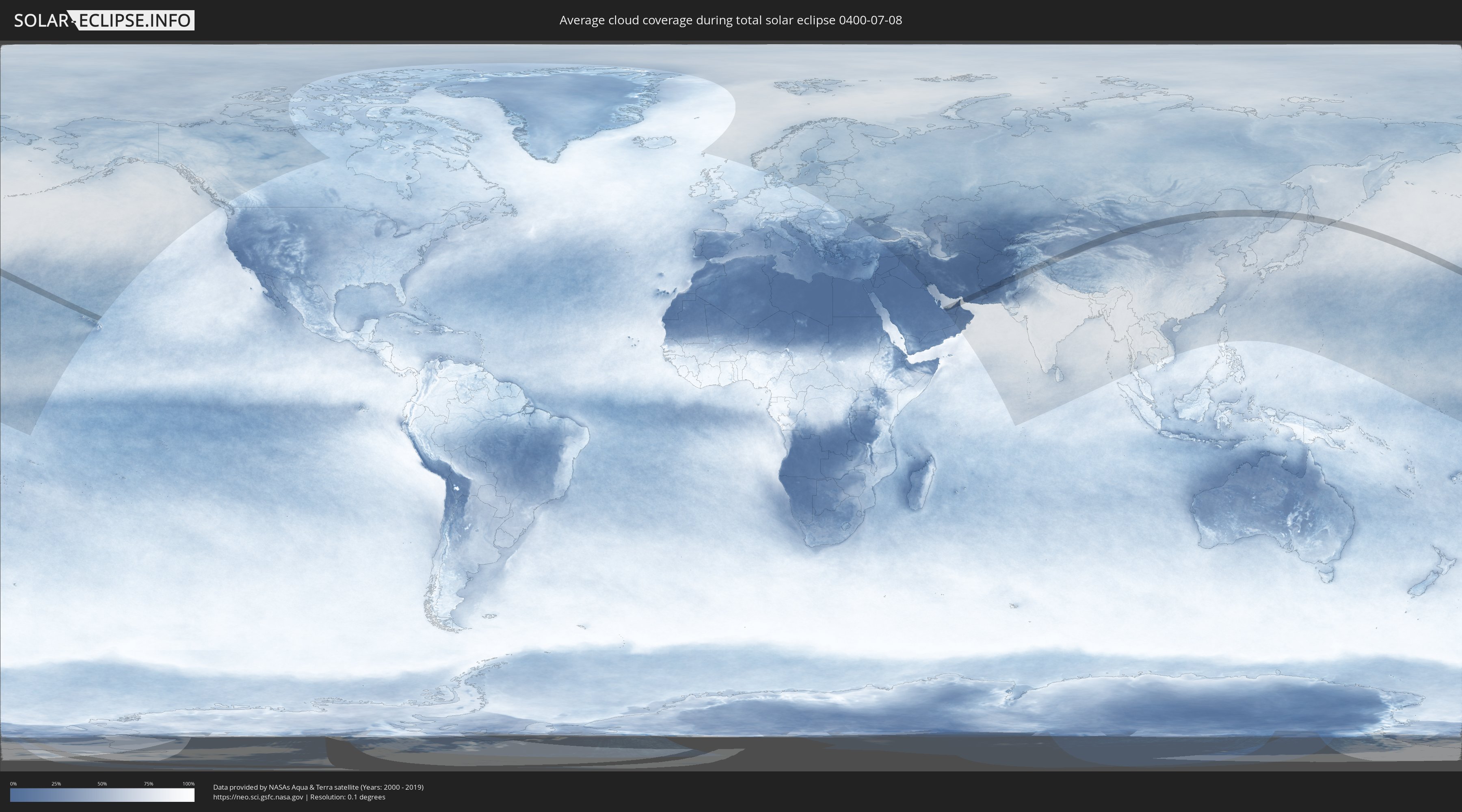
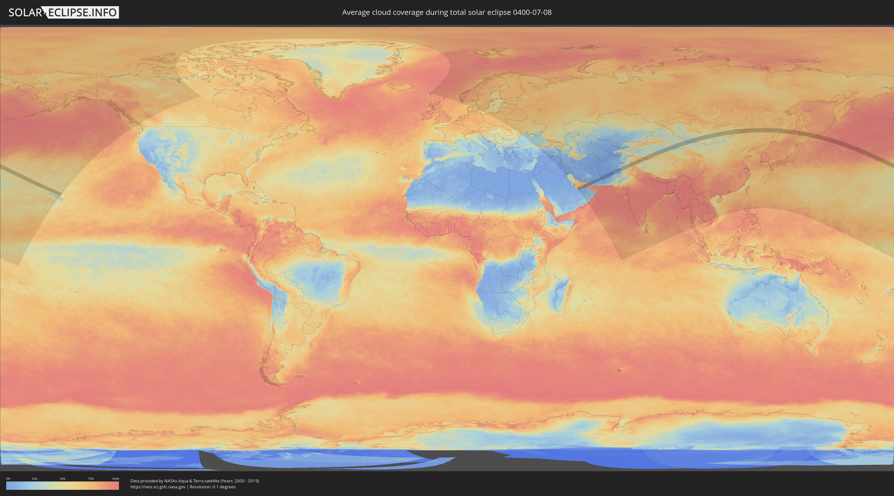
How will be the weather during the total solar eclipse on 07/08/0400?
Where is the best place to see the total solar eclipse of 07/08/0400?
The following maps show the average cloud coverage for the day of the total solar eclipse.
With the help of these maps, it is possible to find the place along the eclipse path, which has the best
chance of a cloudless sky.
Nevertheless, you should consider local circumstances and inform about the weather of your chosen
observation site.
The data is provided by NASAs satellites
AQUA and TERRA.
The cloud maps are averaged over a period of 19 years (2000 - 2019).
Detailed country maps
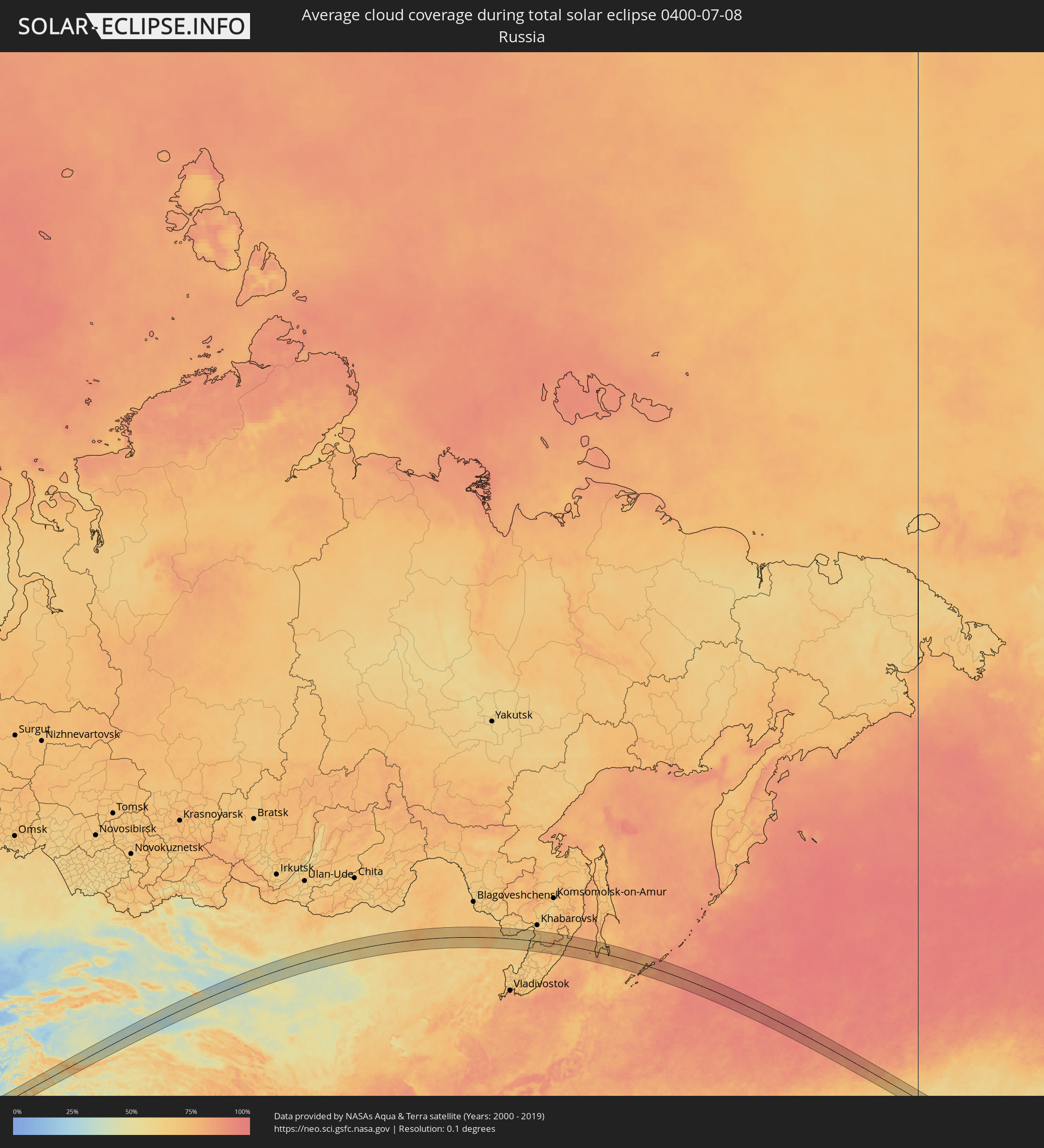 Russia
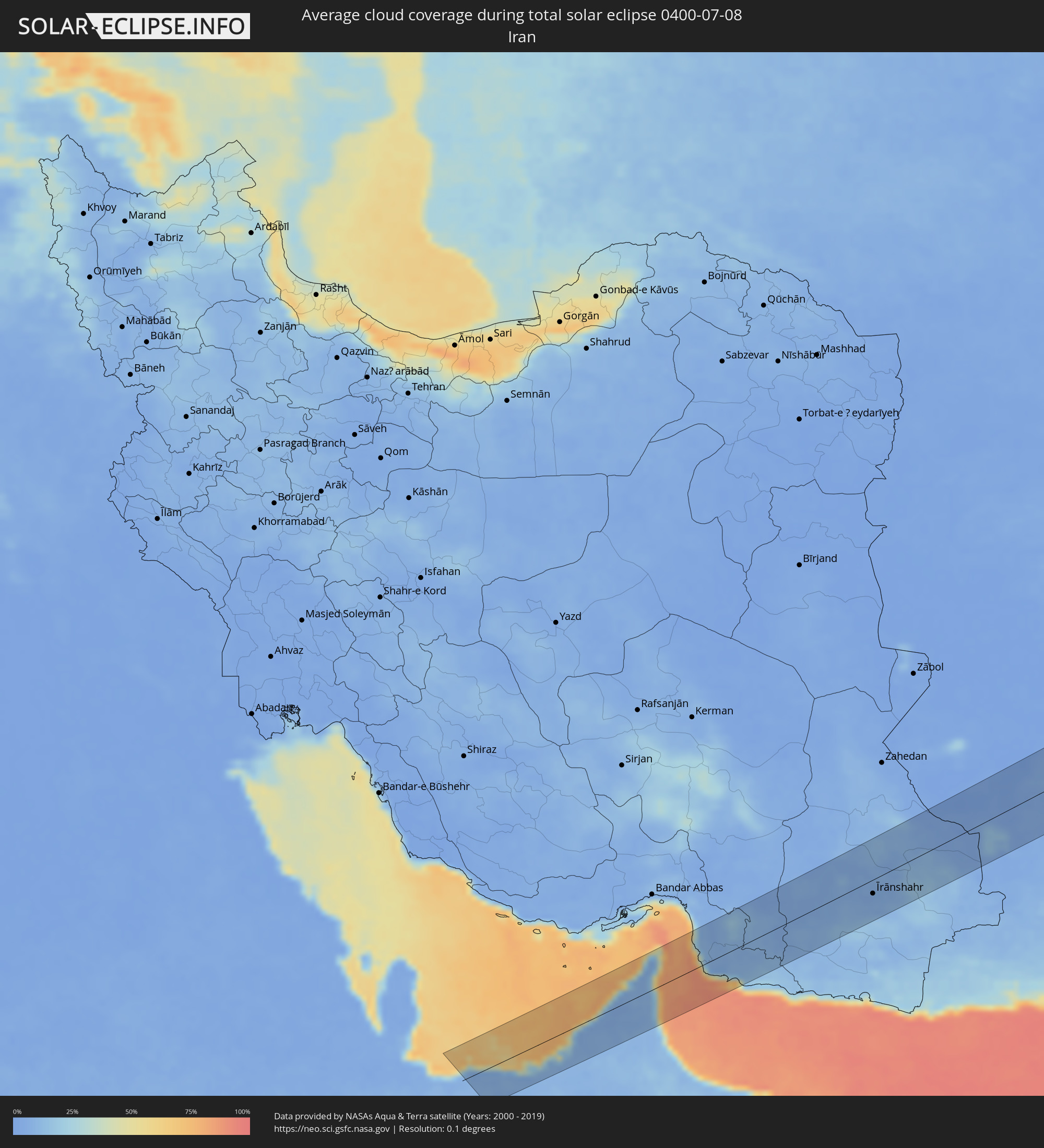 Iran
Iran
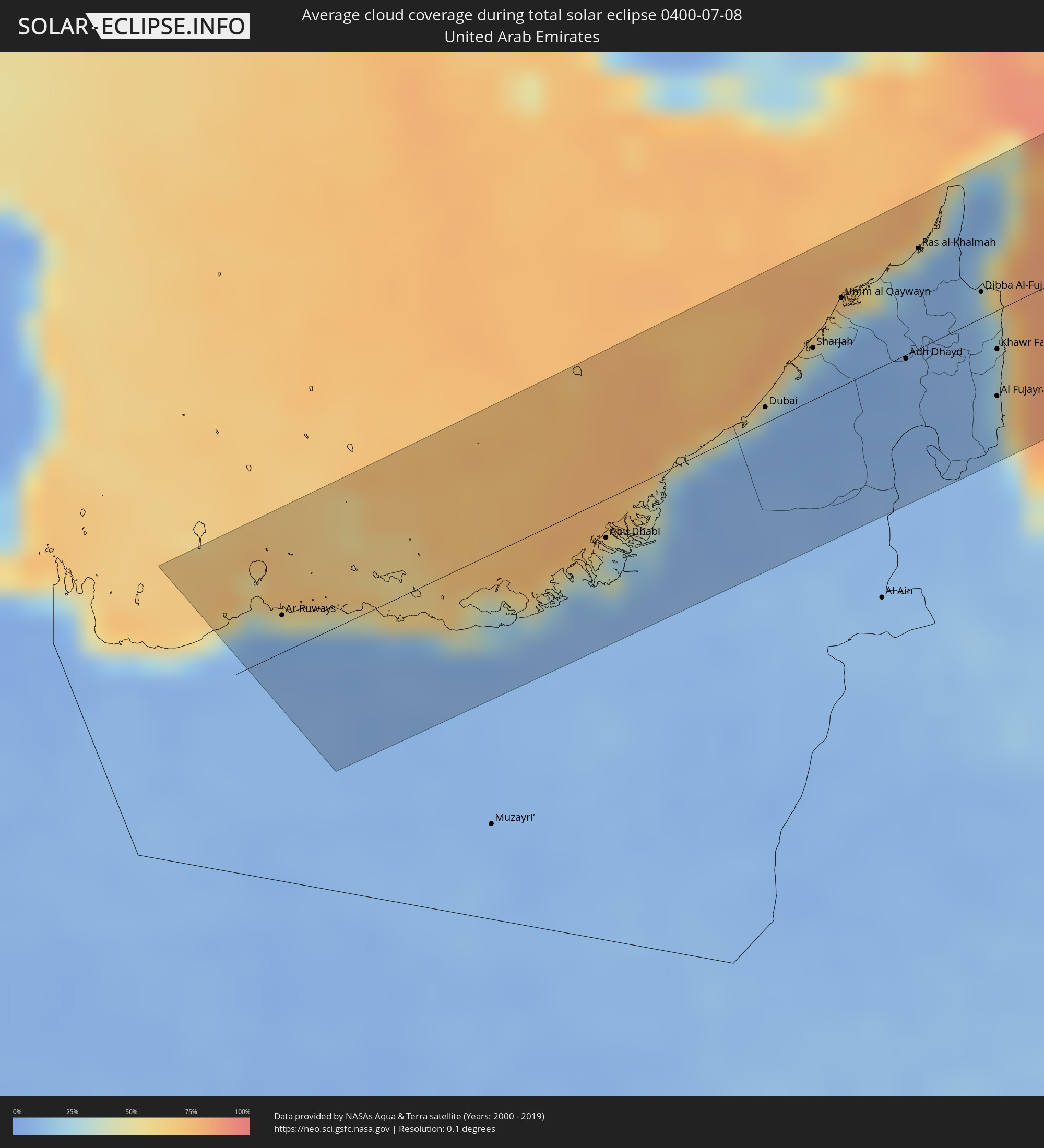 United Arab Emirates
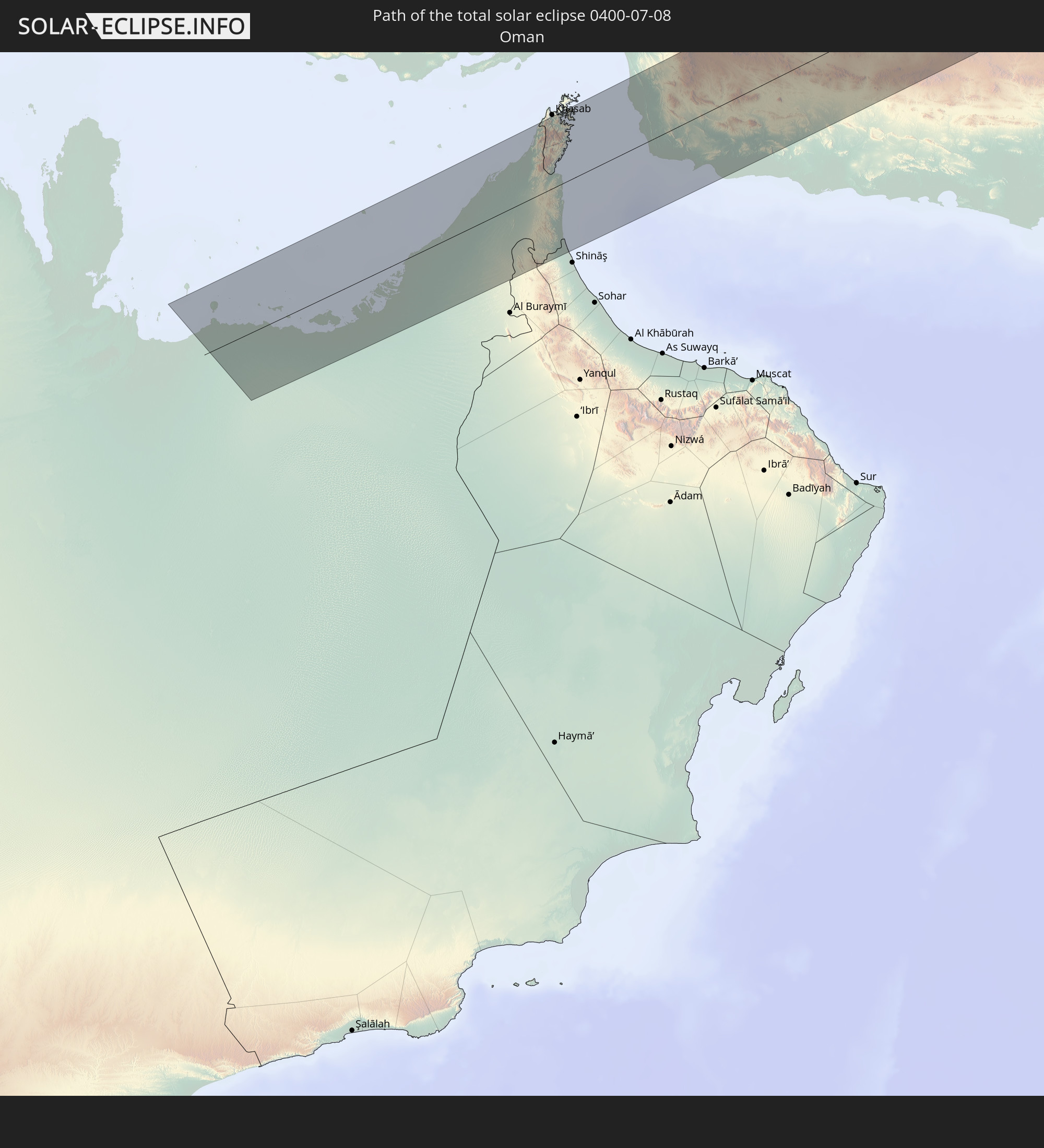
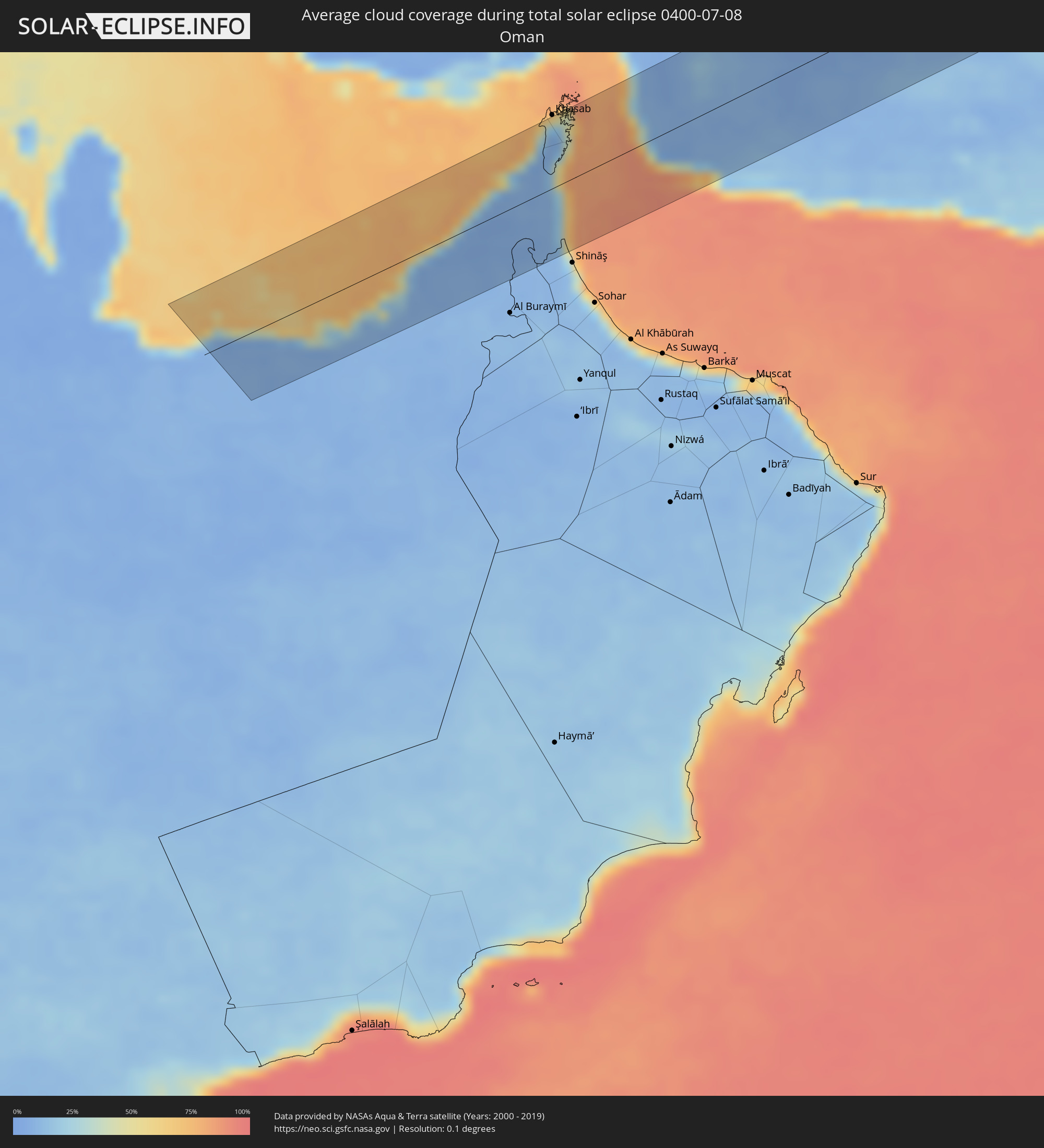 Oman
Oman
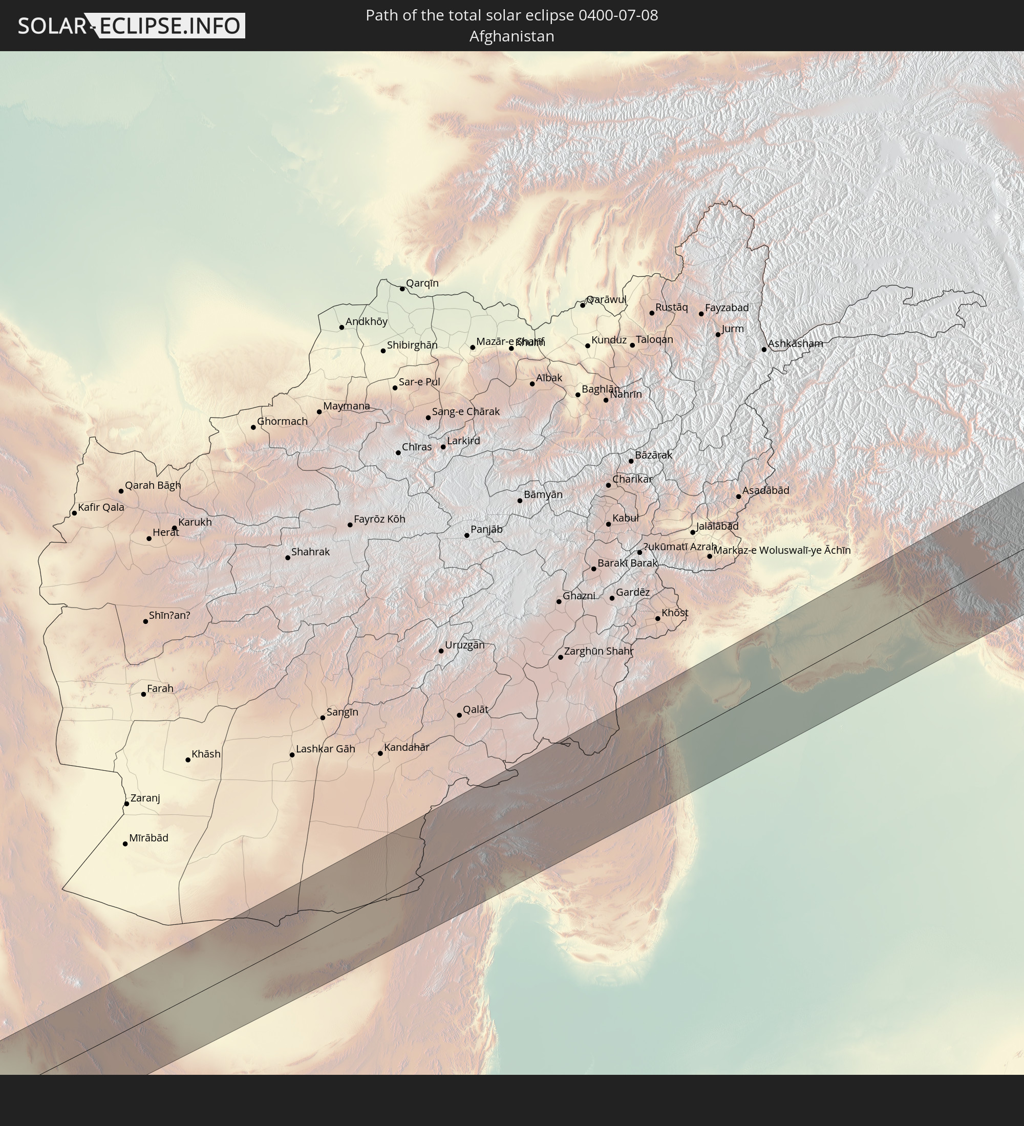
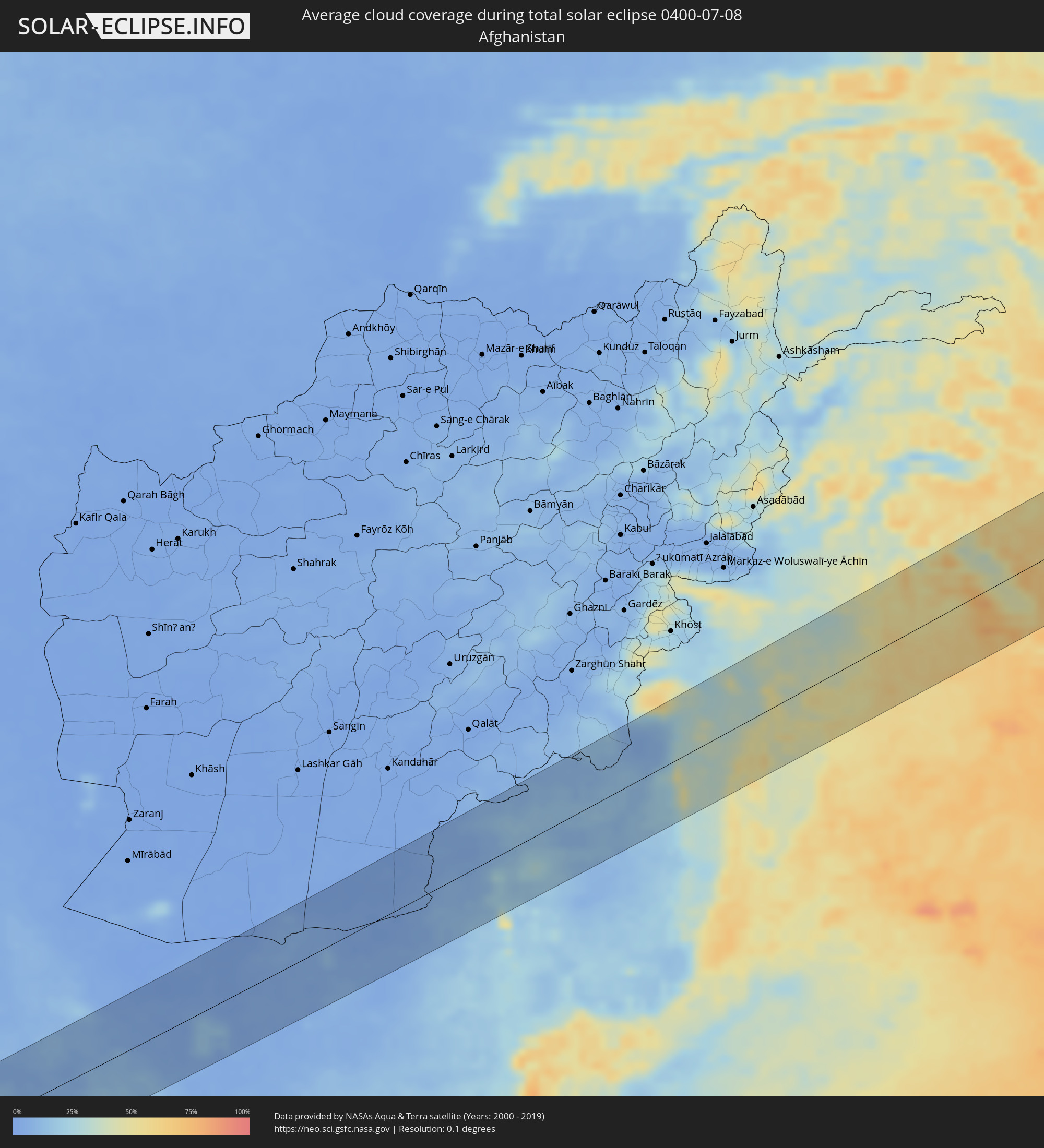 Afghanistan
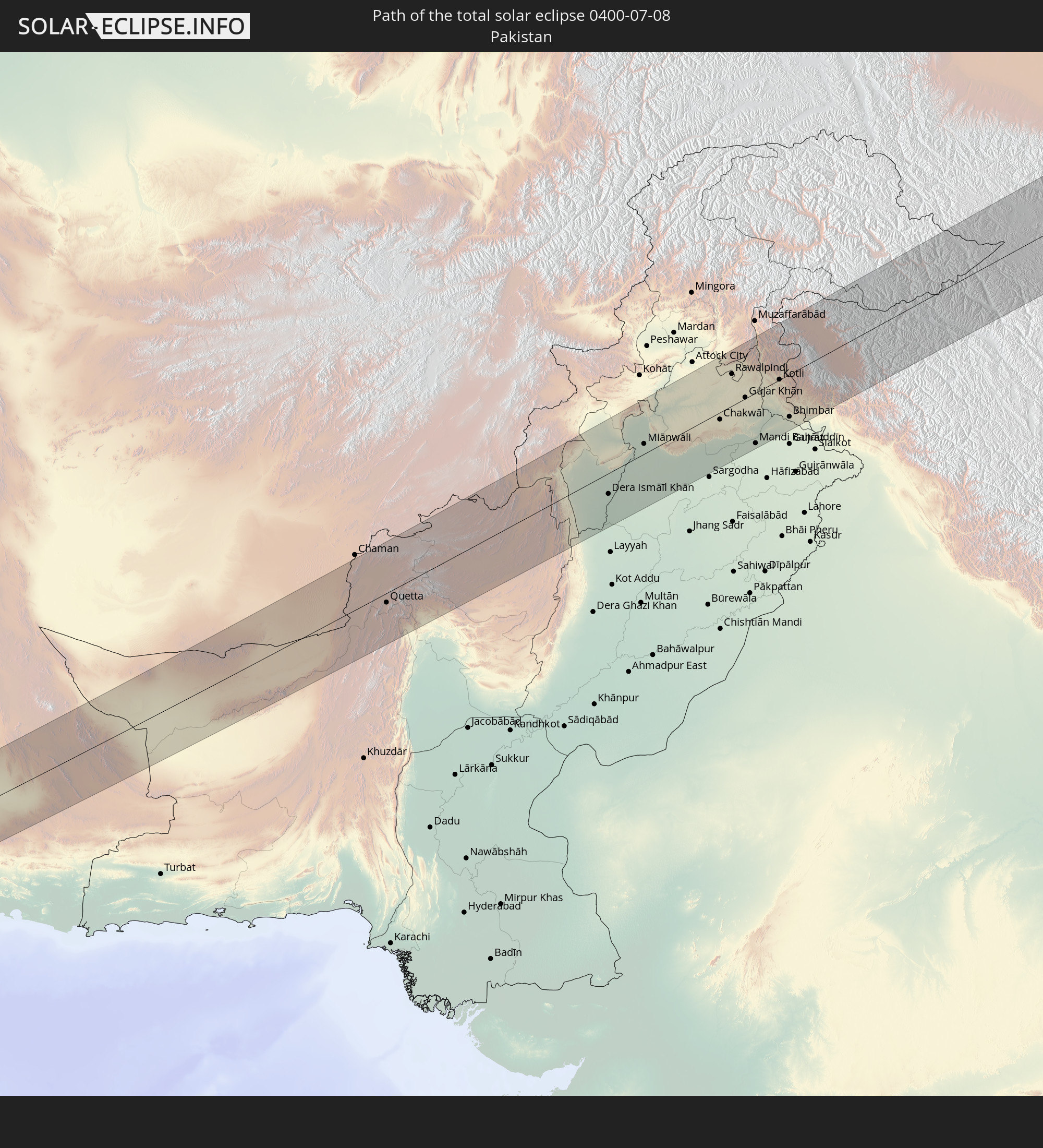
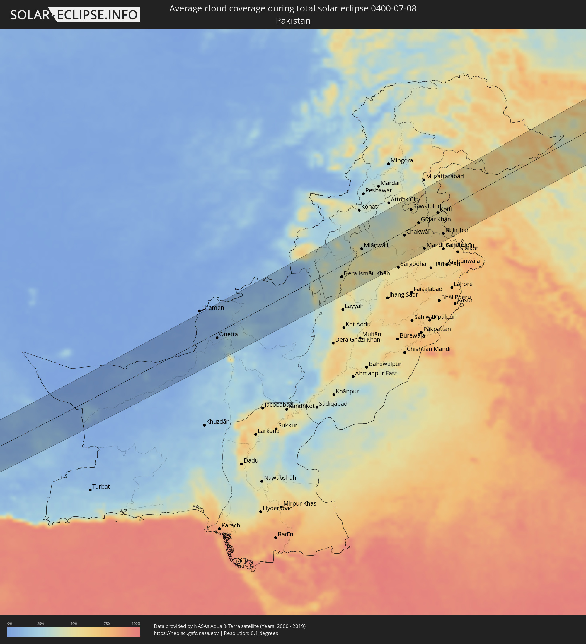 Pakistan
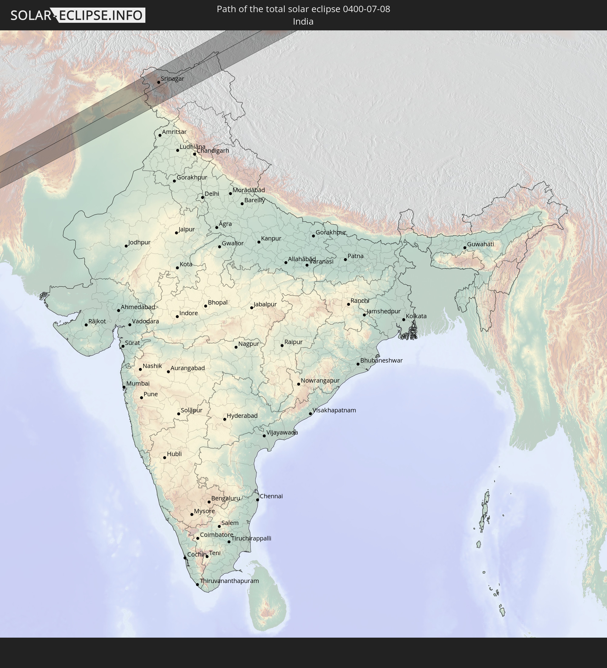
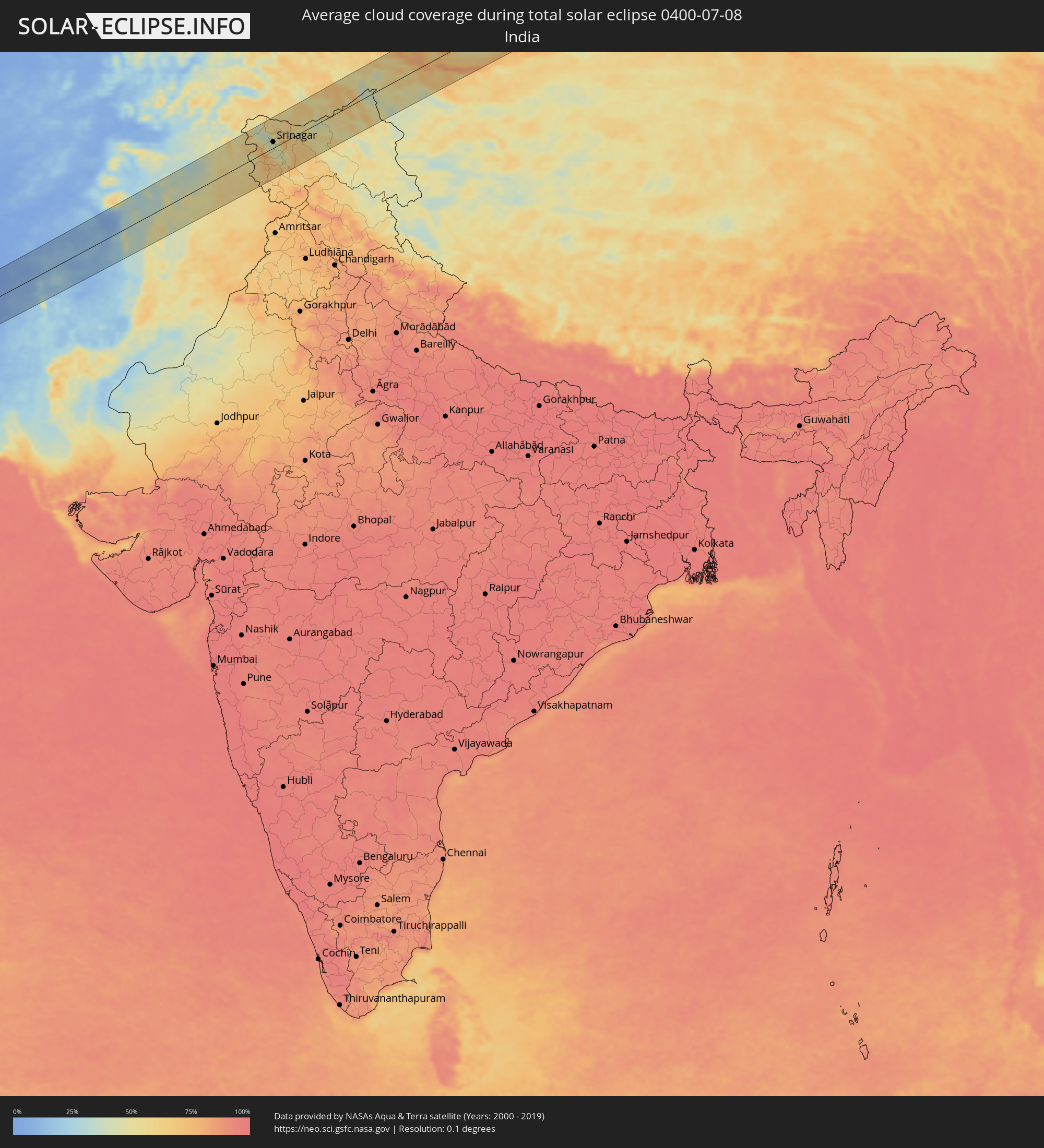 India
India
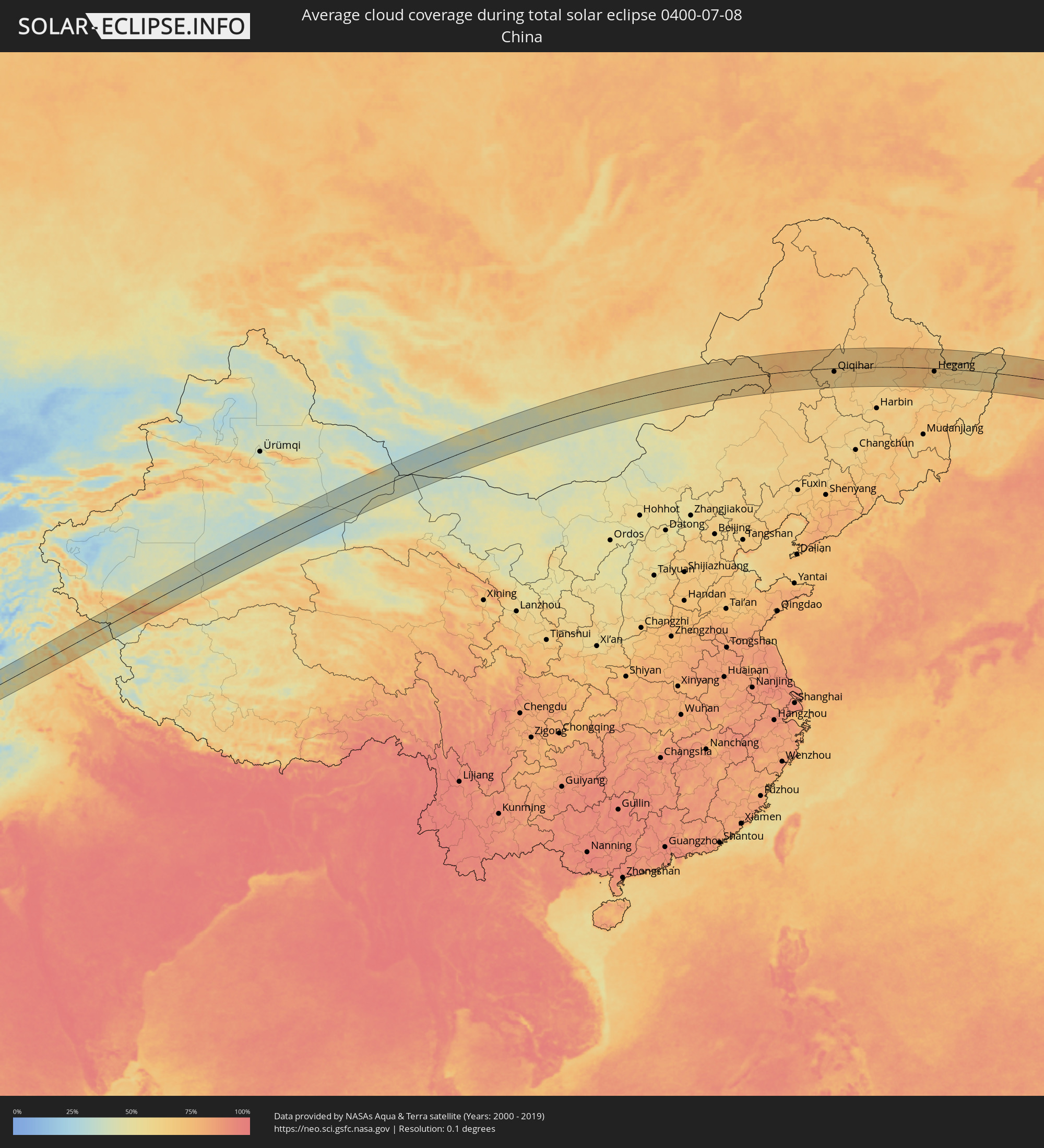 China
China
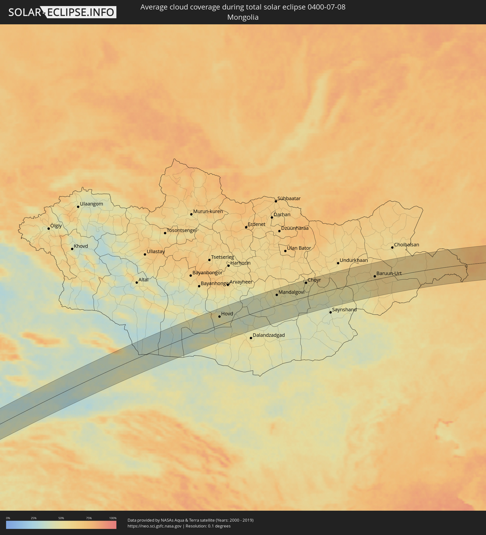 Mongolia
Cities inside the path of the eclipse
The following table shows all locations with a population of more than 5,000 inside the eclipse path. Cities which have more than 100,000 inhabitants are marked bold. A click at the locations opens a detailed map.
| City | Type | Eclipse duration | Local time of max. eclipse | Distance to central line | Ø Cloud coverage |
|
Ar Ruways, Abu Dhabi
|
total | - | 05:30:27 UTC+03:41 | 17 km | 8% |
|
Abu Dhabi, Abu Dhabi
|
total | - | 05:30:12 UTC+03:41 | 18 km | 26% |
|
Dubai, Dubai
|
total | - | 05:30:29 UTC+03:41 | 7 km | 13% |
|
Sharjah, Ash Shāriqah
|
total | - | 05:30:40 UTC+03:41 | 24 km | 11% |
|
Ajman, Ajman
|
total | - | 05:30:44 UTC+03:41 | 30 km | 30% |
|
Umm al Qaywayn, Umm al Qaywayn
|
total | - | 05:30:50 UTC+03:41 | 40 km | 26% |
|
Adh Dhayd, Ash Shāriqah
|
total | - | 05:30:29 UTC+03:41 | 2 km | 7% |
|
Ras al-Khaimah, Raʼs al Khaymah
|
total | - | 05:30:56 UTC+03:41 | 46 km | 37% |
|
Dibba Al-Fujairah, Al Fujayrah
|
total | - | 05:30:40 UTC+03:41 | 12 km | 29% |
|
Dibba Al-Hisn, Al Fujayrah
|
total | - | 05:30:41 UTC+03:41 | 14 km | 29% |
|
Al Fujayrah, Al Fujayrah
|
total | - | 05:30:13 UTC+03:41 | 39 km | 20% |
|
Khawr Fakkān, Ash Shāriqah
|
total | - | 05:30:24 UTC+03:41 | 18 km | 21% |
|
Īrānshahr, Sistan and Baluchestan
|
total | - | 05:15:51 UTC+03:25 | 24 km | 6% |
|
Khāsh, Sistan and Baluchestan
|
total | - | 05:16:49 UTC+03:25 | 53 km | 9% |
|
Mastung, Balochistān
|
total | - | 06:20:46 UTC+04:28 | 46 km | 11% |
|
Quetta, Balochistān
|
total | - | 06:21:14 UTC+04:28 | 14 km | 8% |
|
Loralai, Balochistān
|
total | - | 06:21:33 UTC+04:28 | 69 km | 11% |
|
Zhob, Balochistān
|
total | - | 06:22:47 UTC+04:28 | 12 km | 12% |
|
Tānk, Khyber Pakhtunkhwa
|
total | - | 06:23:59 UTC+04:28 | 31 km | 38% |
|
Dera Ismāīl Khān, Khyber Pakhtunkhwa
|
total | - | 06:23:37 UTC+04:28 | 30 km | 53% |
|
Lakki Marwat, Khyber Pakhtunkhwa
|
total | - | 06:24:34 UTC+04:28 | 45 km | 33% |
|
Bhakkar, Punjab
|
total | - | 06:23:23 UTC+04:28 | 58 km | 50% |
|
Dullewāla, Punjab
|
total | - | 06:23:43 UTC+04:28 | 54 km | 48% |
|
Miānwāli, Punjab
|
total | - | 06:24:38 UTC+04:28 | 14 km | 47% |
|
Pindi Gheb, Punjab
|
total | - | 06:25:38 UTC+04:28 | 46 km | 36% |
|
Khushāb, Punjab
|
total | - | 06:24:29 UTC+04:28 | 50 km | 56% |
|
Talagang, Punjab
|
total | - | 06:25:17 UTC+04:28 | 9 km | 41% |
|
Jhawāriān, Punjab
|
total | - | 06:24:37 UTC+04:28 | 56 km | 51% |
|
Chakwāl, Punjab
|
total | - | 06:25:24 UTC+04:28 | 10 km | 52% |
|
Bhalwāl, Punjab
|
total | - | 06:24:35 UTC+04:28 | 77 km | 57% |
|
Bhera, Punjab
|
total | - | 06:24:51 UTC+04:28 | 57 km | 55% |
|
Khewra, Punjab
|
total | - | 06:25:05 UTC+04:28 | 45 km | 57% |
|
Rawalpindi, Punjab
|
total | - | 06:26:18 UTC+04:28 | 45 km | 53% |
|
Malakwal City, Punjab
|
total | - | 06:25:01 UTC+04:28 | 63 km | 59% |
|
Gūjar Khān, Punjab
|
total | - | 06:25:55 UTC+04:28 | 1 km | 61% |
|
Mandi Bahāuddīn, Punjab
|
total | - | 06:25:07 UTC+04:28 | 73 km | 55% |
|
Kāmra, Punjab
|
total | - | 06:26:36 UTC+04:28 | 40 km | 54% |
|
Dinga, Punjab
|
total | - | 06:25:15 UTC+04:28 | 78 km | 55% |
|
Jhelum, Punjab
|
total | - | 06:25:37 UTC+04:28 | 49 km | 59% |
|
Rāwala Kot, Azad Kashmir
|
total | - | 06:26:49 UTC+04:28 | 40 km | 56% |
|
Khāriān, Punjab
|
total | - | 06:25:31 UTC+04:28 | 68 km | 58% |
|
Kotli, Azad Kashmir
|
total | - | 06:26:25 UTC+04:28 | 0 km | 56% |
|
Uri, Kashmir
|
total | - | 07:20:09 UTC+05:21 | 48 km | 56% |
|
Bhimbar, Azad Kashmir
|
total | - | 06:25:47 UTC+04:28 | 61 km | 62% |
|
Pūnch, Kashmir
|
total | - | 07:19:46 UTC+05:21 | 16 km | 49% |
|
Kupwāra, Kashmir
|
total | - | 07:20:09 UTC+05:21 | 34 km | 73% |
|
Rajaori, Kashmir
|
total | - | 07:19:19 UTC+05:21 | 32 km | 59% |
|
Bāramūla, Kashmir
|
total | - | 07:20:25 UTC+05:21 | 48 km | 48% |
|
Sopur, Kashmir
|
total | - | 07:20:33 UTC+05:21 | 50 km | 38% |
|
Pattan, Kashmir
|
total | - | 07:20:25 UTC+05:21 | 34 km | 39% |
|
Hājan, Kashmir
|
total | - | 07:20:37 UTC+05:21 | 45 km | 39% |
|
Bandipura, Kashmir
|
total | - | 07:20:46 UTC+05:21 | 55 km | 37% |
|
Sumbal, Kashmir
|
total | - | 07:20:32 UTC+05:21 | 37 km | 39% |
|
Soyībug, Kashmir
|
total | - | 07:20:21 UTC+05:21 | 19 km | 43% |
|
Tsrār Sharīf, Kashmir
|
total | - | 07:20:06 UTC+05:21 | 5 km | 48% |
|
Gāndarbal, Kashmir
|
total | - | 07:20:34 UTC+05:21 | 30 km | 42% |
|
Srinagar, Kashmir
|
total | - | 07:20:24 UTC+05:21 | 15 km | 43% |
|
Shupīyan, Kashmir
|
total | - | 07:19:56 UTC+05:21 | 22 km | 59% |
|
Pulwama, Kashmir
|
total | - | 07:20:09 UTC+05:21 | 9 km | 45% |
|
Awantipur, Kashmir
|
total | - | 07:20:15 UTC+05:21 | 10 km | 45% |
|
Kulgam, Kashmir
|
total | - | 07:19:54 UTC+05:21 | 37 km | 59% |
|
Bijbehara, Kashmir
|
total | - | 07:20:07 UTC+05:21 | 27 km | 45% |
|
Trāl, Kashmir
|
total | - | 07:20:17 UTC+05:21 | 14 km | 47% |
|
Qāzigund, Kashmir
|
total | - | 07:19:56 UTC+05:21 | 43 km | 58% |
|
Anantnag, Kashmir
|
total | - | 07:20:03 UTC+05:21 | 35 km | 48% |
|
Pahlgām, Kashmir
|
total | - | 07:20:28 UTC+05:21 | 14 km | 64% |
|
Kargil, Kashmir
|
total | - | 07:21:28 UTC+05:21 | 3 km | 43% |
|
Hovd, Övörhangay
|
total | - | 09:44:15 UTC+07:07 | 43 km | 46% |
|
Mandalgovi, Middle Govĭ
|
total | - | 09:51:13 UTC+07:07 | 55 km | 47% |
|
Choyr, Govĭ-Sumber
|
total | - | 09:54:55 UTC+07:07 | 73 km | 50% |
|
Baruun-Urt, Sühbaatar
|
total | - | 10:02:54 UTC+07:07 | 16 km | 58% |
|
Zhalantun, Inner Mongolia
|
total | - | 11:12:13 UTC+08:00 | 63 km | 72% |
|
Nianzishan, Heilongjiang
|
total | - | 11:12:19 UTC+08:00 | 7 km | 65% |
|
Longjiang, Heilongjiang
|
total | - | 11:12:47 UTC+08:00 | 15 km | 64% |
|
Gannan, Heilongjiang
|
total | - | 11:13:32 UTC+08:00 | 49 km | 68% |
|
Hulan Ergi, Heilongjiang
|
total | - | 11:13:34 UTC+08:00 | 31 km | 65% |
|
Qiqihar, Heilongjiang
|
total | - | 11:14:11 UTC+08:00 | 17 km | 65% |
|
Taikang, Heilongjiang
|
total | - | 11:14:57 UTC+08:00 | 72 km | 62% |
|
Fuyu, Heilongjiang
|
total | - | 11:15:11 UTC+08:00 | 32 km | 66% |
|
Mingshui, Heilongjiang
|
total | - | 11:17:40 UTC+08:00 | 40 km | 67% |
|
Baiquan, Heilongjiang
|
total | - | 11:18:03 UTC+08:00 | 7 km | 69% |
|
Wangkui, Heilongjiang
|
total | - | 11:18:41 UTC+08:00 | 79 km | 62% |
|
Bei’an, Heilongjiang
|
total | - | 11:19:03 UTC+08:00 | 80 km | 65% |
|
Hailun, Heilongjiang
|
total | - | 11:19:37 UTC+08:00 | 10 km | 67% |
|
Suileng, Heilongjiang
|
total | - | 11:19:51 UTC+08:00 | 33 km | 64% |
|
Tieli, Heilongjiang
|
total | - | 11:21:35 UTC+08:00 | 62 km | 65% |
|
Youhao, Heilongjiang
|
total | - | 11:23:00 UTC+08:00 | 36 km | 68% |
|
Langxiang, Heilongjiang
|
total | - | 11:23:06 UTC+08:00 | 65 km | 74% |
|
Yichun, Heilongjiang
|
total | - | 11:23:05 UTC+08:00 | 21 km | 71% |
|
Lianhe, Heilongjiang
|
total | - | 11:23:50 UTC+08:00 | 43 km | 71% |
|
Xinqing, Heilongjiang
|
total | - | 11:24:12 UTC+08:00 | 86 km | 69% |
|
Hegang, Heilongjiang
|
total | - | 11:25:41 UTC+08:00 | 16 km | 70% |
|
Jiamusi, Heilongjiang
|
total | - | 11:25:48 UTC+08:00 | 77 km | 68% |
|
Fengxiang, Heilongjiang
|
total | - | 11:26:36 UTC+08:00 | 11 km | 67% |
|
Amurzet, Jewish Autonomous Oblast
|
total | - | 12:14:35 UTC+08:47 | 26 km | 64% |
|
Fuli, Heilongjiang
|
total | - | 11:27:20 UTC+08:00 | 82 km | 68% |
|
Shuangyashan, Heilongjiang
|
total | - | 11:27:22 UTC+08:00 | 92 km | 68% |
|
Fujin, Heilongjiang
|
total | - | 11:28:51 UTC+08:00 | 18 km | 62% |
|
Leninskoye, Jewish Autonomous Oblast
|
total | - | 12:17:15 UTC+08:47 | 61 km | 61% |
|
Luchegorsk, Primorskiy
|
total | - | 12:20:34 UTC+08:47 | 89 km | 68% |
|
Bikin, Khabarovsk Krai
|
total | - | 12:20:32 UTC+08:47 | 51 km | 63% |
|
Vyazemskiy, Khabarovsk Krai
|
total | - | 12:21:10 UTC+08:47 | 33 km | 65% |
|
Khor, Khabarovsk Krai
|
total | - | 12:21:22 UTC+08:47 | 74 km | 63% |
|
Gornozavodsk, Sakhalin
|
total | - | 14:01:27 UTC+10:14 | 19 km | 77% |
|
Nevel’sk, Sakhalin
|
total | - | 14:01:22 UTC+10:14 | 32 km | 76% |
|
Kholmsk, Sakhalin
|
total | - | 14:01:24 UTC+10:14 | 75 km | 73% |
|
Aniva, Sakhalin
|
total | - | 14:02:28 UTC+10:14 | 48 km | 73% |
|
Yuzhno-Sakhalinsk, Sakhalin
|
total | - | 14:02:37 UTC+10:14 | 77 km | 72% |
|
Korsakov, Sakhalin
|
total | - | 14:02:57 UTC+10:14 | 43 km | 70% |