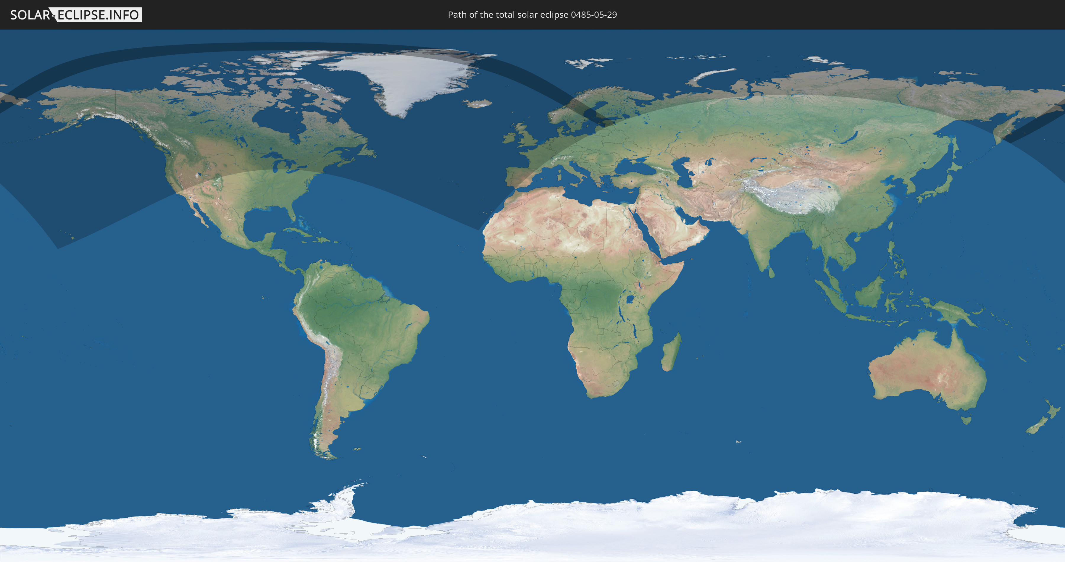
Total solar eclipse of 05/29/0485
| Day of week: | Tuesday |
| Maximum duration of eclipse: | 02m26s |
| Maximum width of eclipse path: | 301 km |
| Saros cycle: | 74 |
| Coverage: | 100% |
| Magnitude: | 1.042 |
| Gamma: | 0.8814 |
Wo kann man die Sonnenfinsternis vom 05/29/0485 sehen?
Die Sonnenfinsternis am 05/29/0485 kann man in 31 Ländern als partielle Sonnenfinsternis beobachten.
Der Finsternispfad verläuft durch 9 Länder. Nur in diesen Ländern ist sie als total Sonnenfinsternis zu sehen.
In den folgenden Ländern ist die Sonnenfinsternis total zu sehen
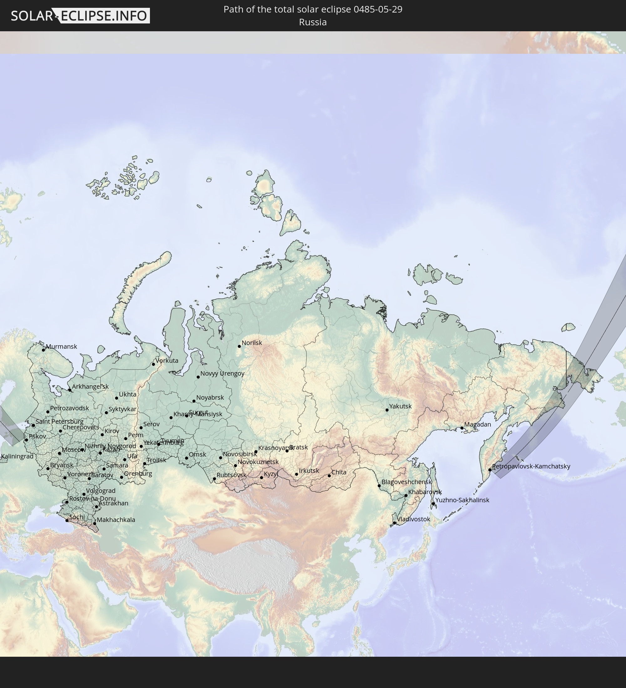 Russia
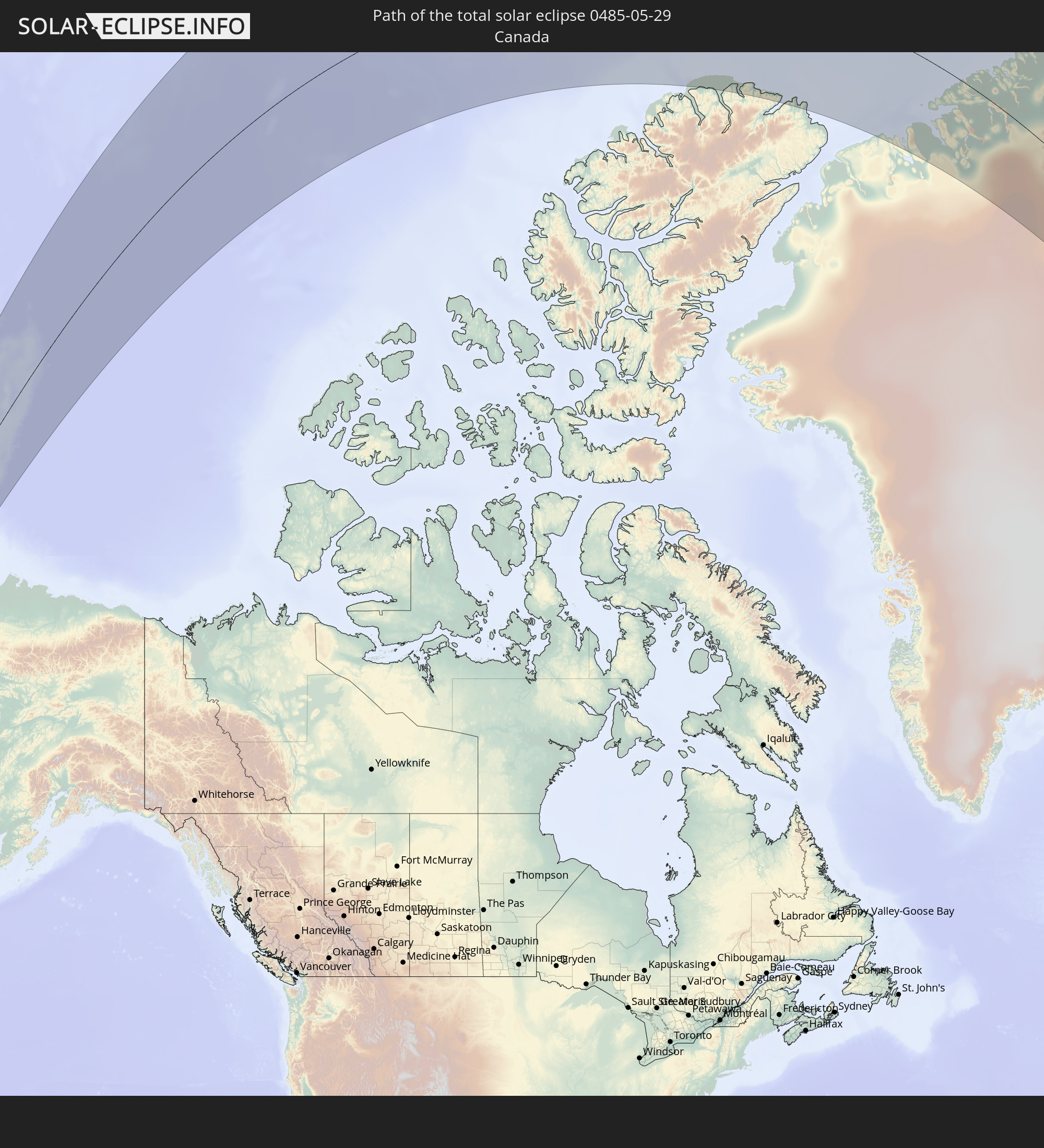 Canada
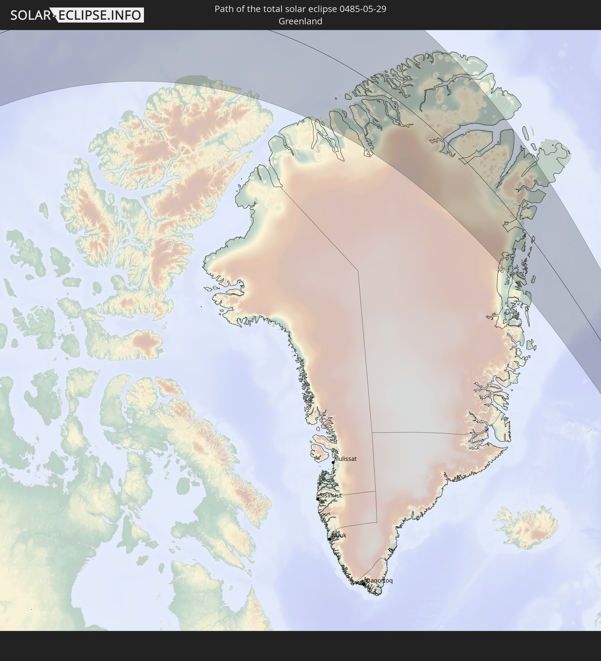 Greenland
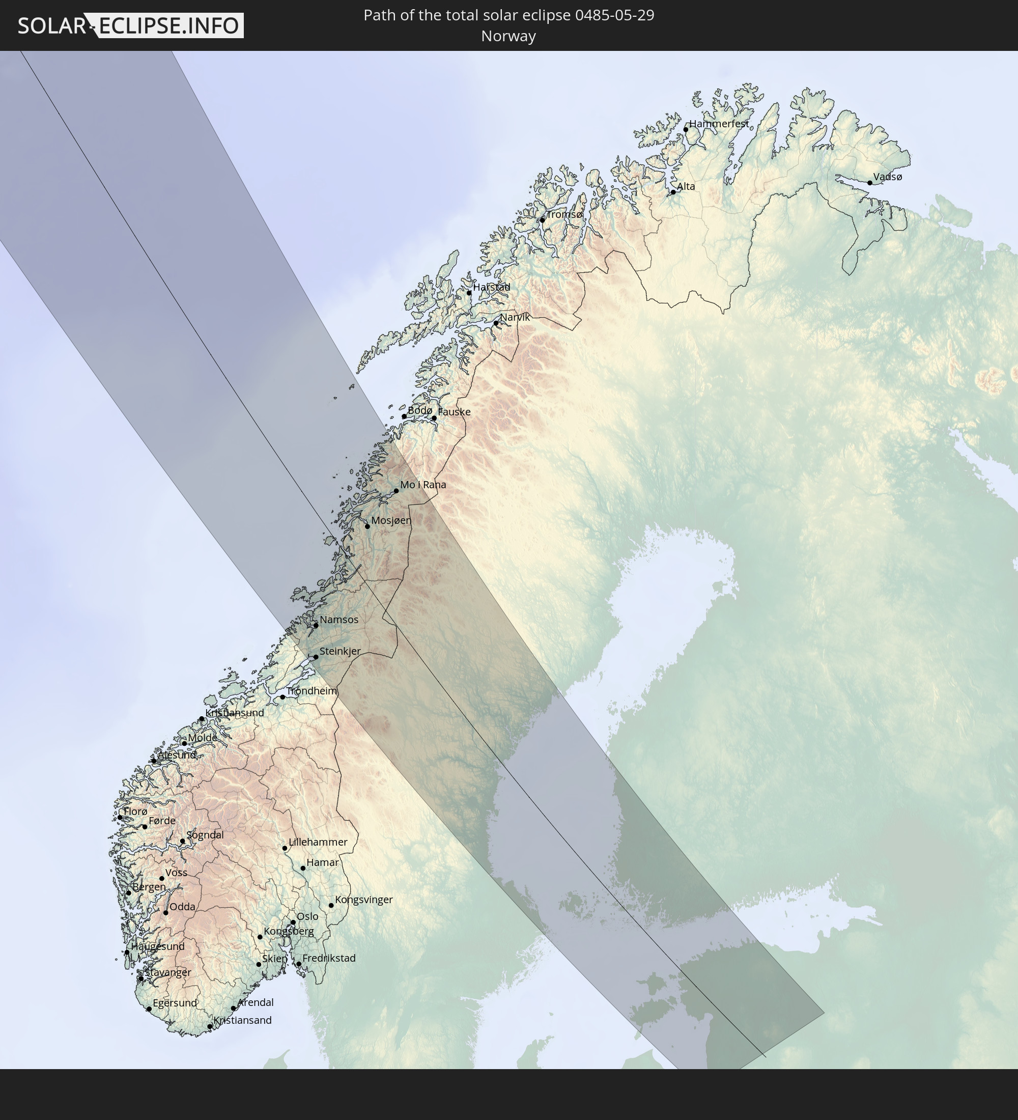 Norway
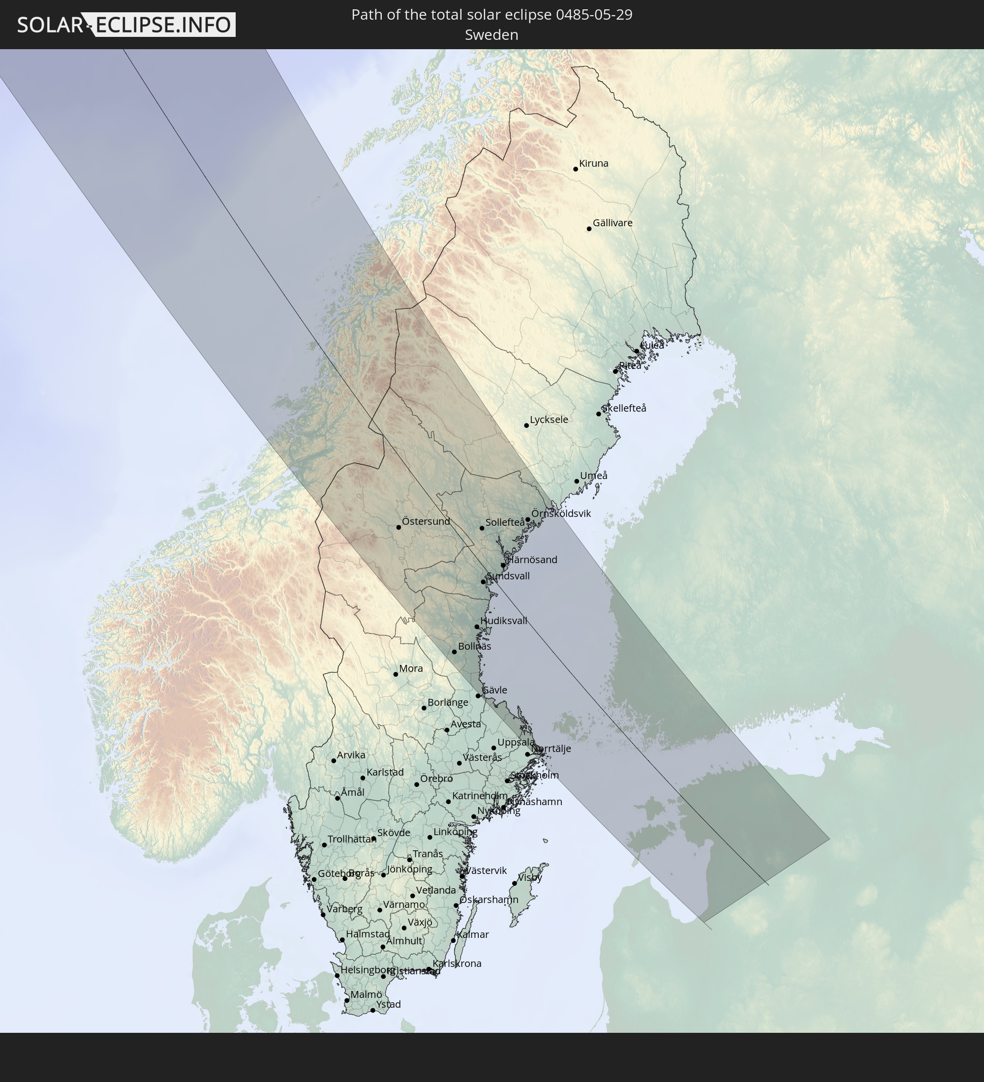 Sweden
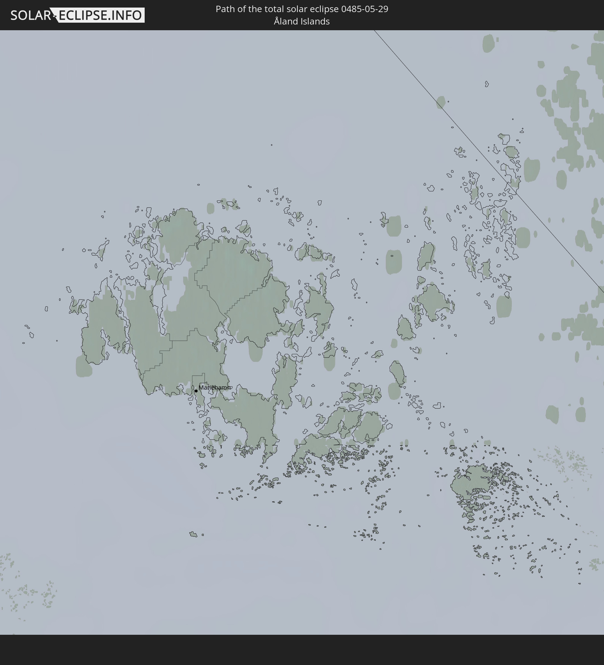 Åland Islands
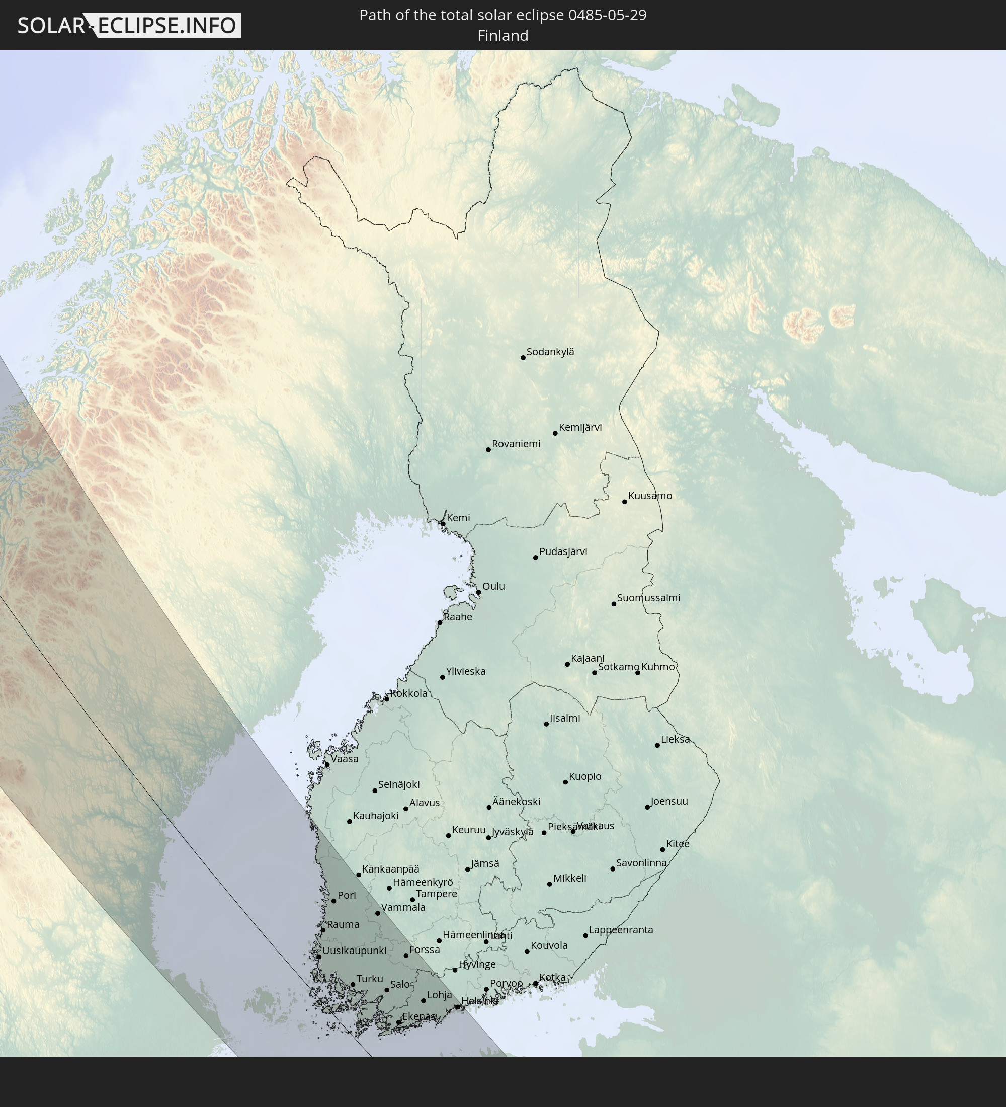 Finland
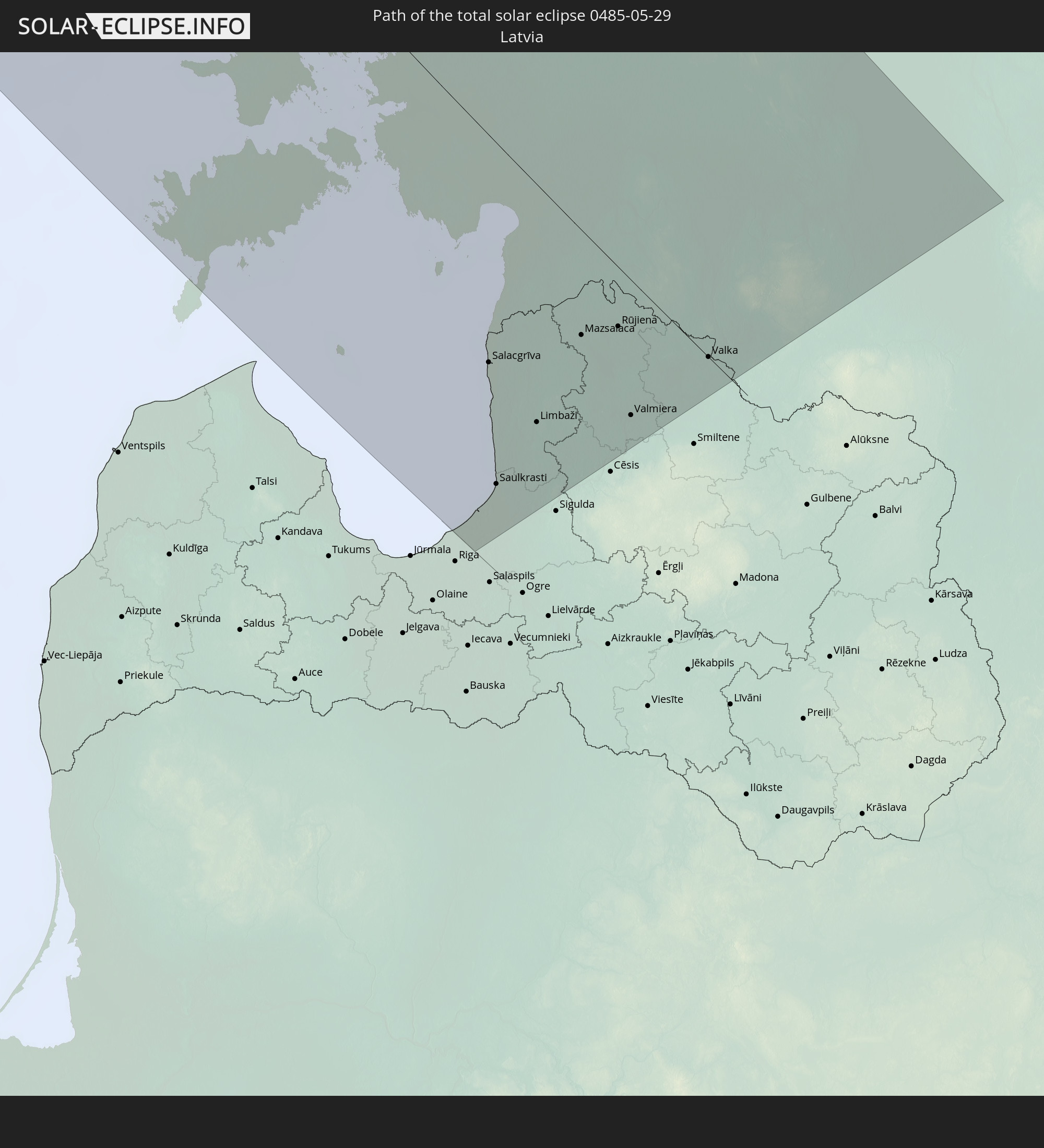 Latvia
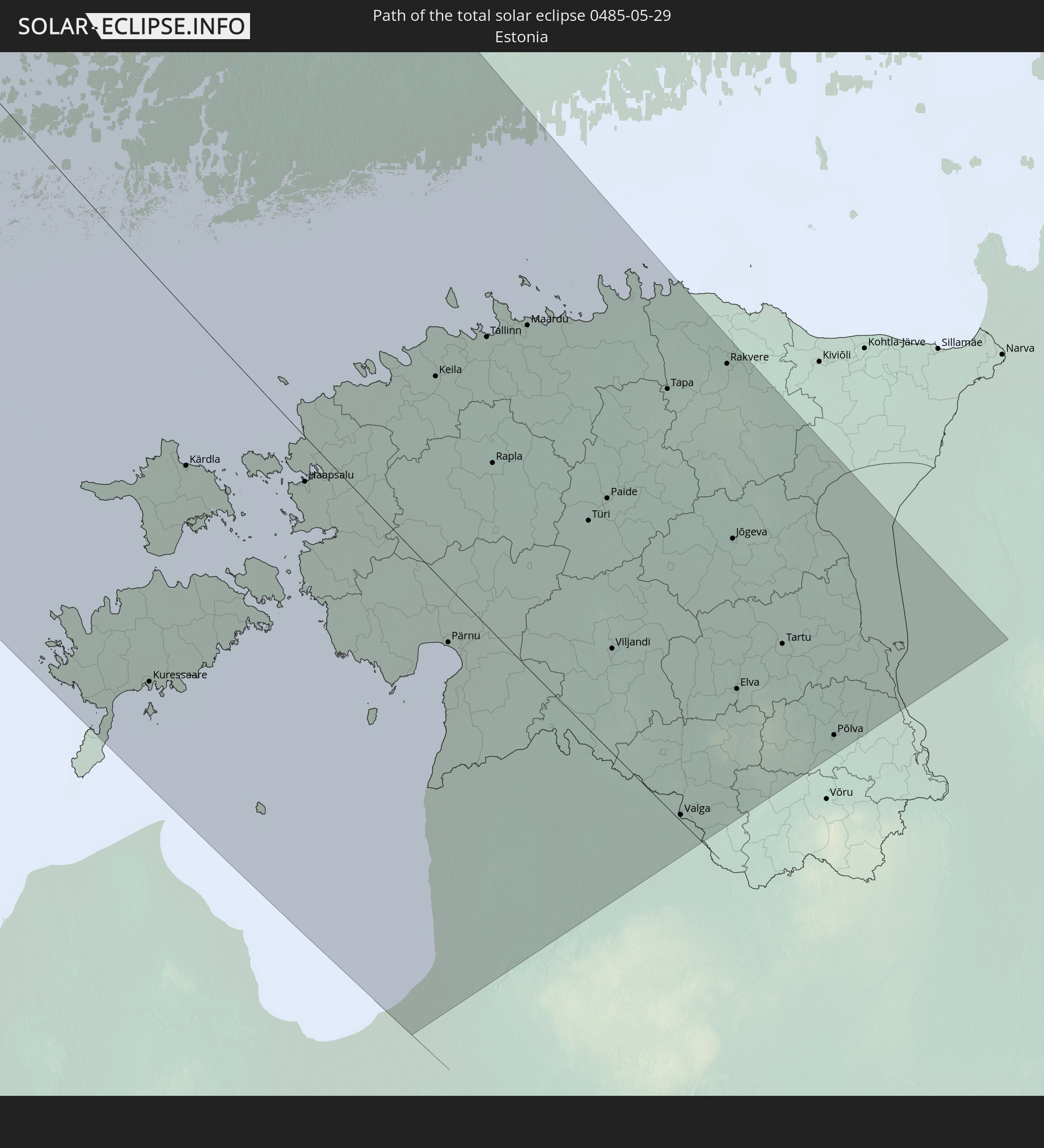 Estonia
In den folgenden Ländern ist die Sonnenfinsternis partiell zu sehen
 Russia
 United States
 United States Minor Outlying Islands
 Canada
 Greenland
 Saint Pierre and Miquelon
 Portugal
 Iceland
 Spain
Spain
 Republic of Ireland
 Svalbard and Jan Mayen
 United Kingdom
 Faroe Islands
 France
 Isle of Man
 Guernsey
 Jersey
 Belgium
 Netherlands
 Norway
 Luxembourg
 Germany
 Switzerland
 Denmark
 Sweden
 Poland
 Åland Islands
 Finland
 Lithuania
 Latvia
 Estonia
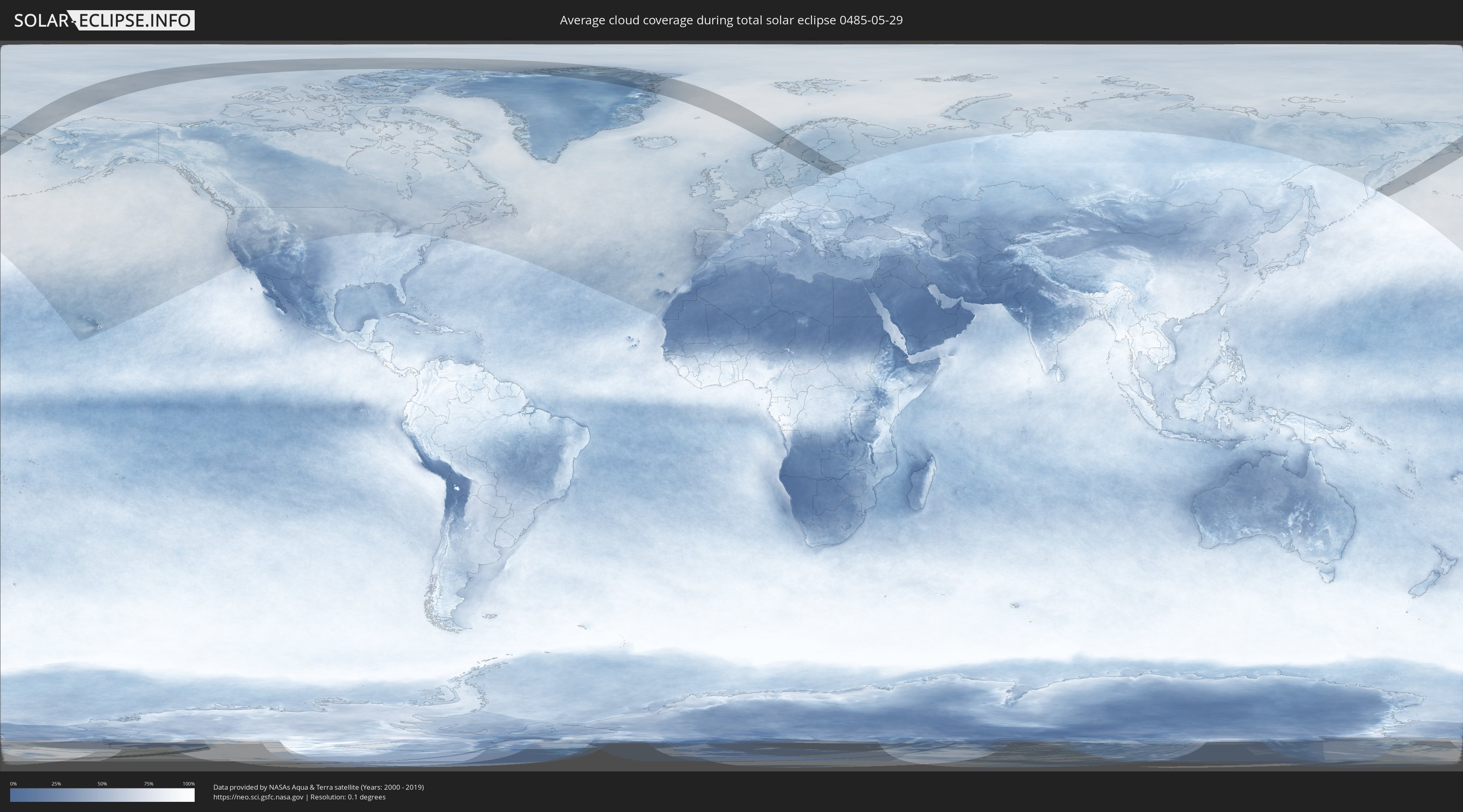
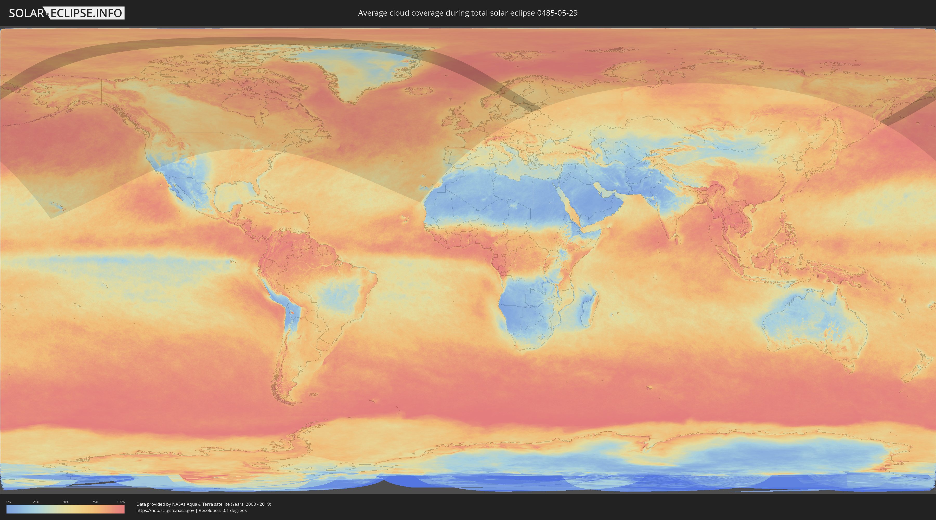
How will be the weather during the total solar eclipse on 05/29/0485?
Where is the best place to see the total solar eclipse of 05/29/0485?
The following maps show the average cloud coverage for the day of the total solar eclipse.
With the help of these maps, it is possible to find the place along the eclipse path, which has the best
chance of a cloudless sky.
Nevertheless, you should consider local circumstances and inform about the weather of your chosen
observation site.
The data is provided by NASAs satellites
AQUA and TERRA.
The cloud maps are averaged over a period of 19 years (2000 - 2019).
Detailed country maps
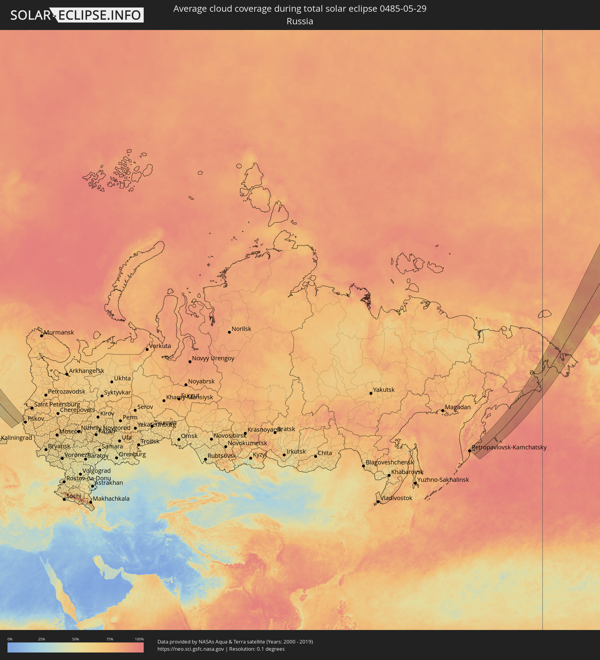 Russia
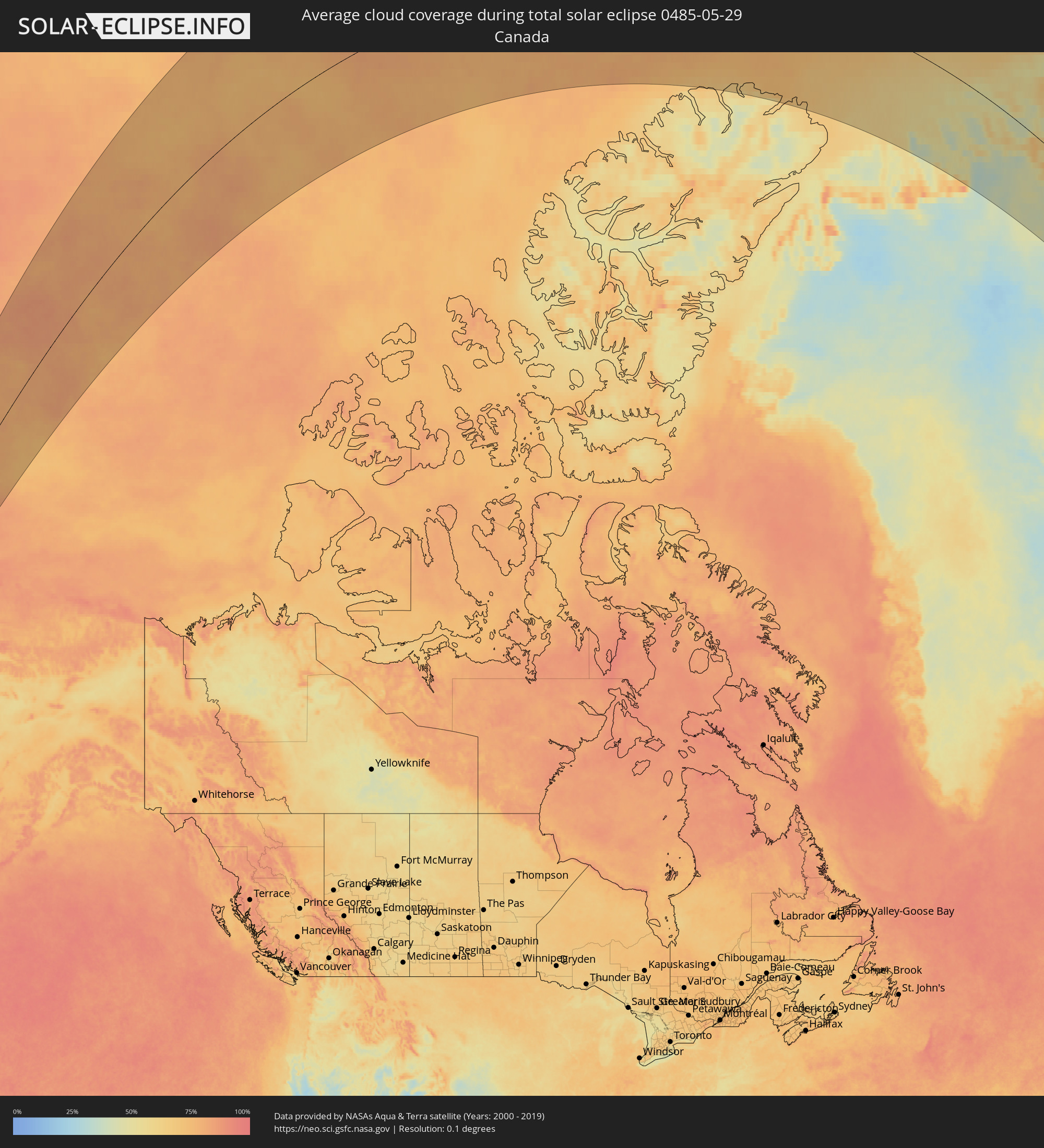 Canada
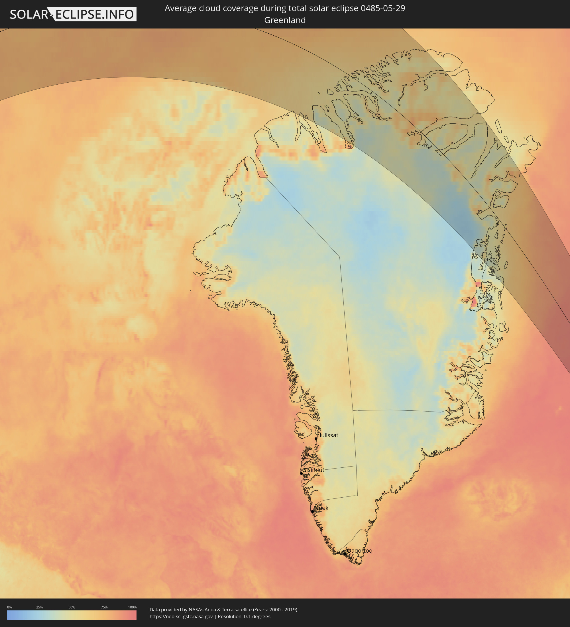 Greenland
 Norway
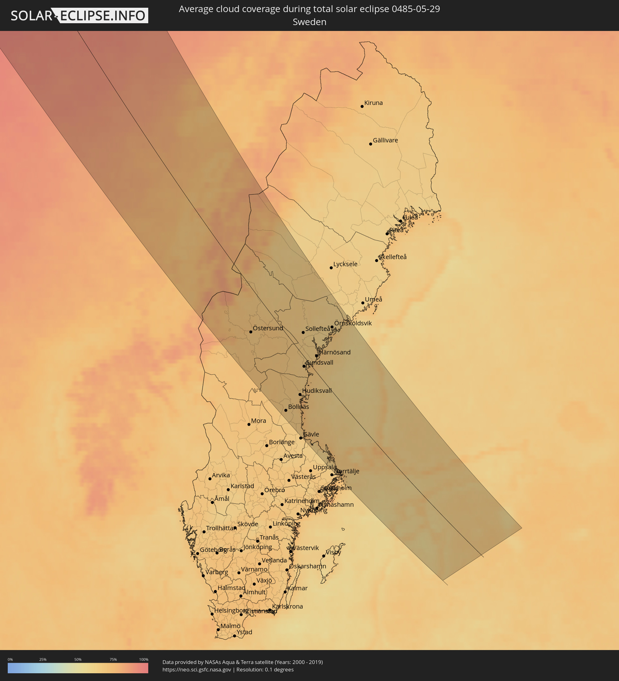 Sweden
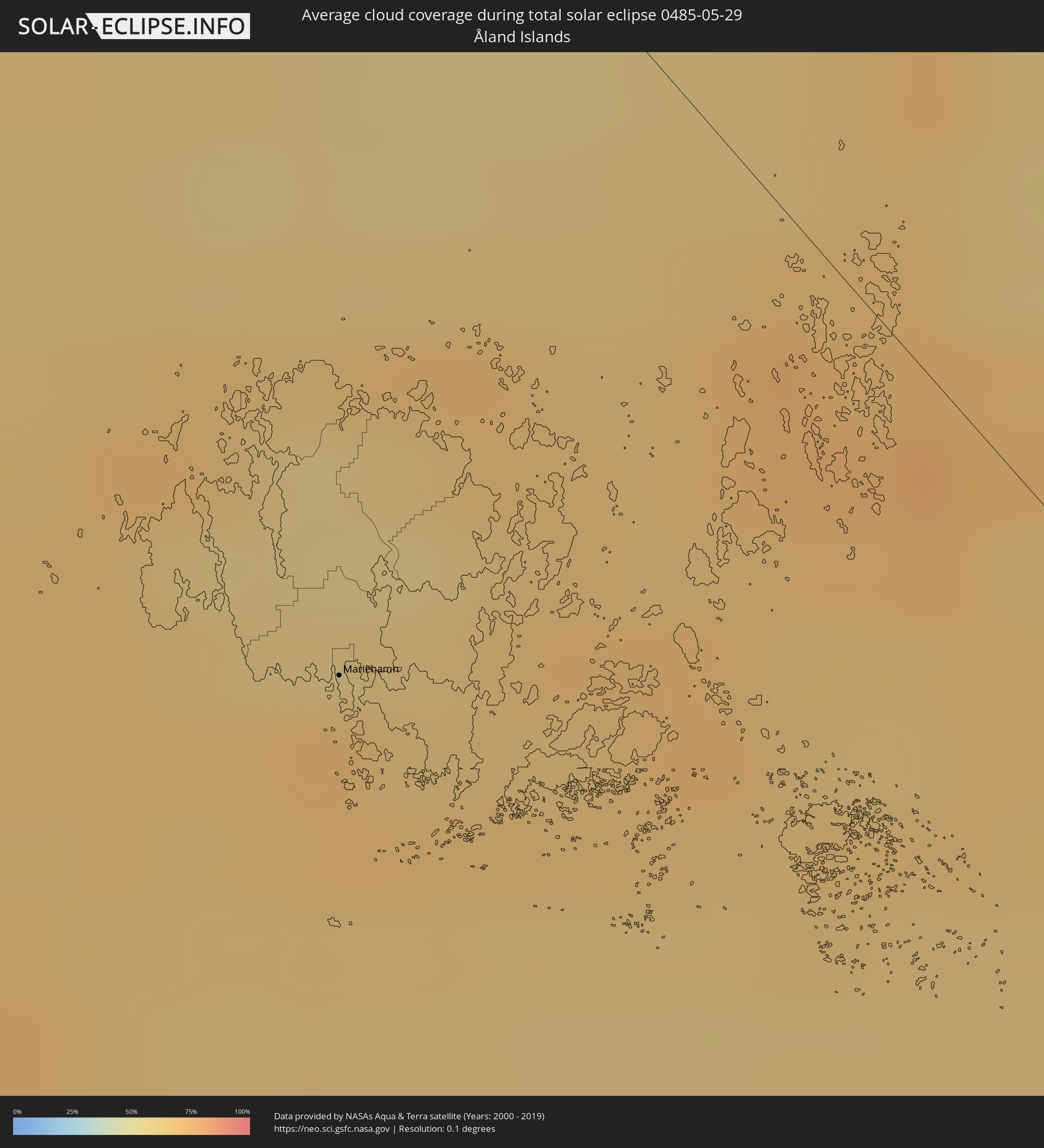 Åland Islands
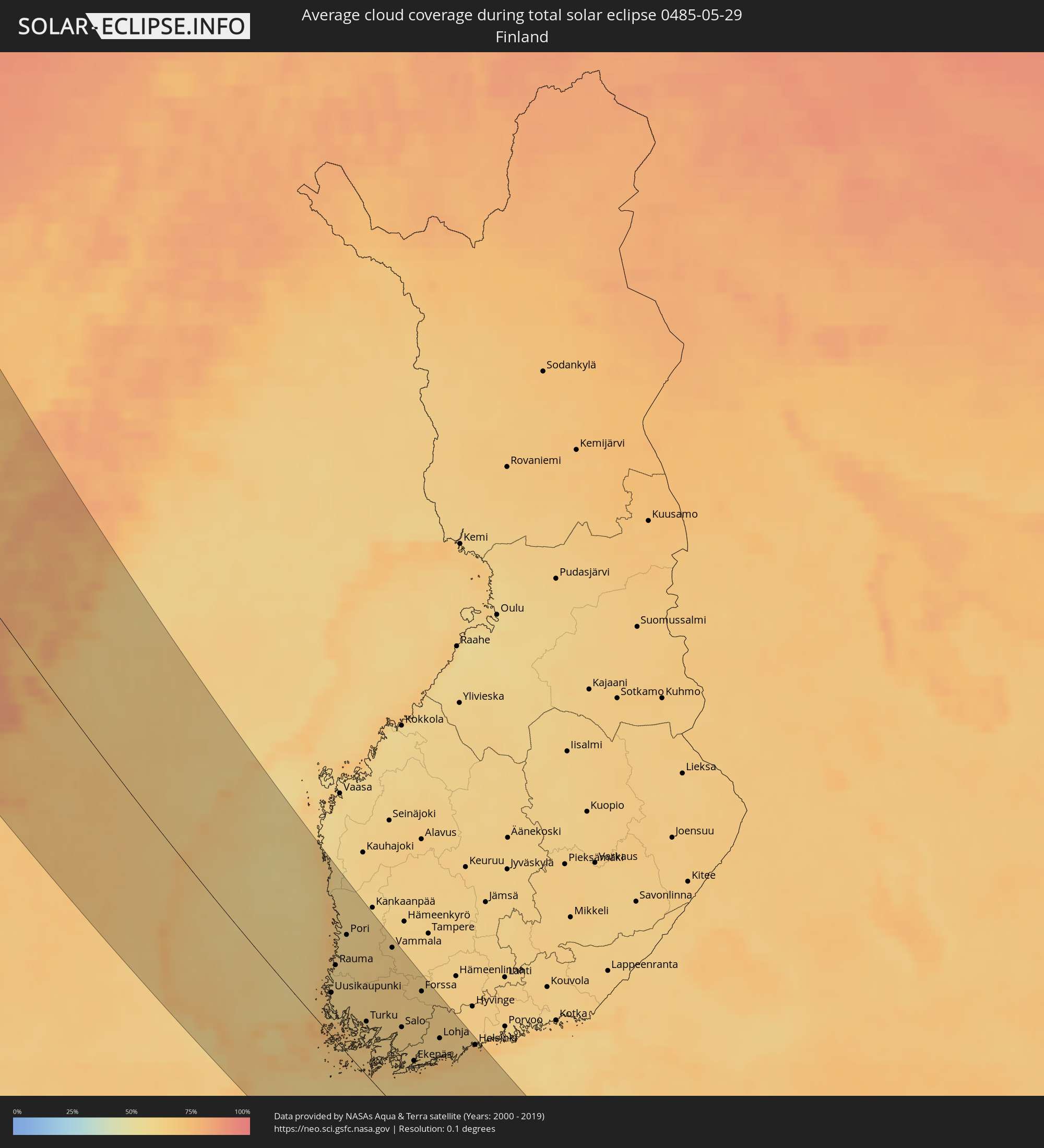 Finland
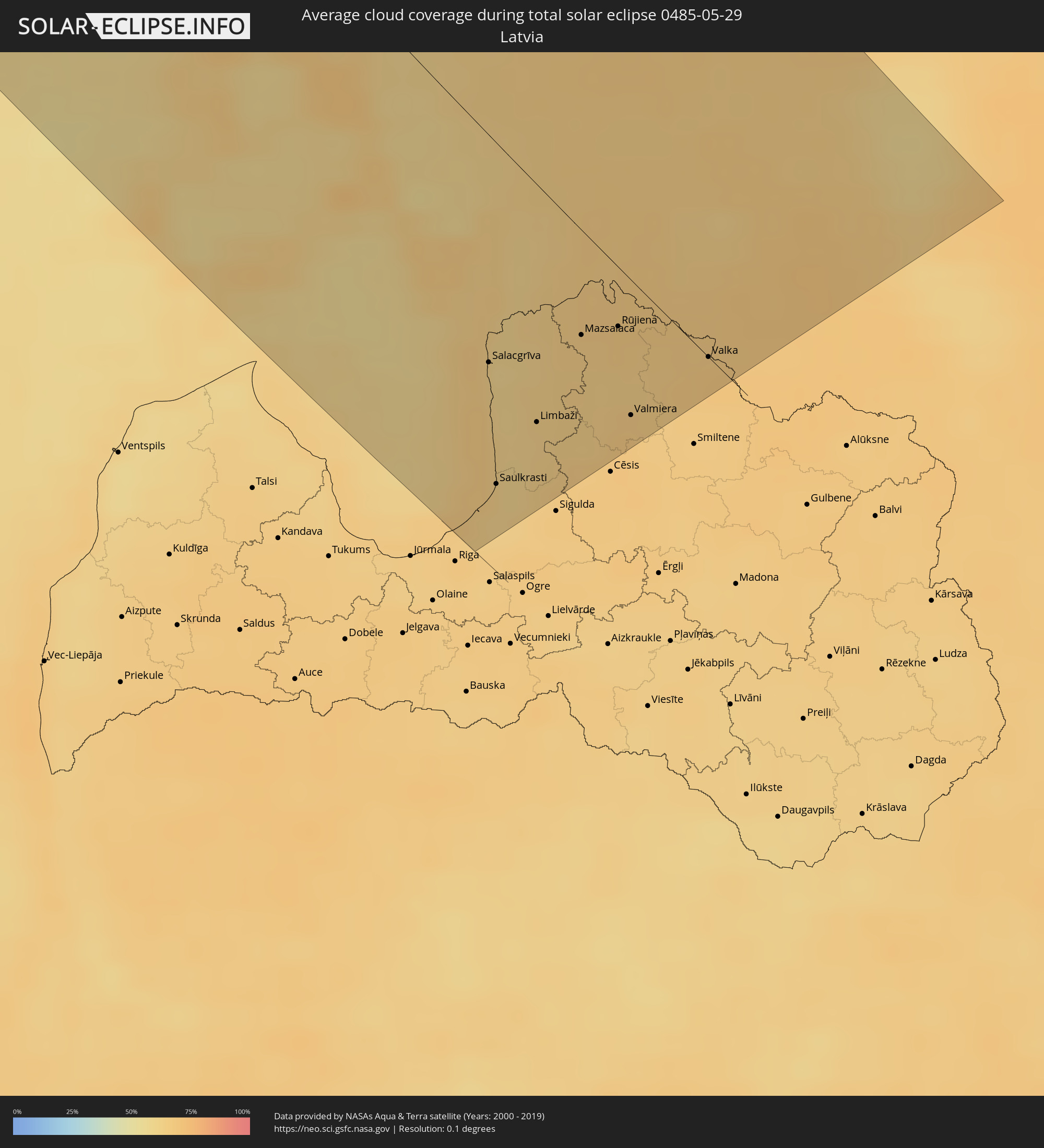 Latvia
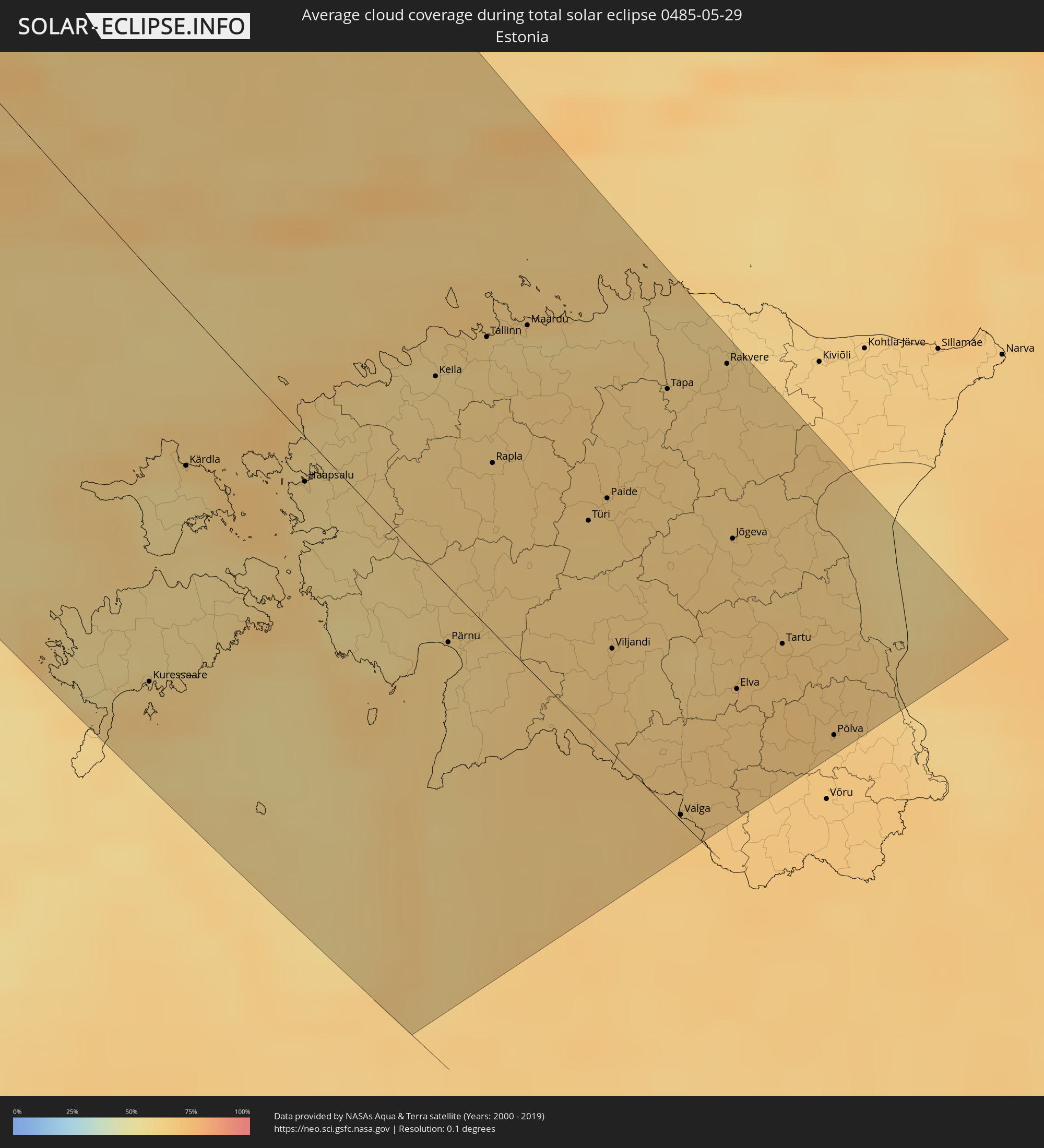 Estonia
Cities inside the path of the eclipse
The following table shows all locations with a population of more than 5,000 inside the eclipse path. Cities which have more than 100,000 inhabitants are marked bold. A click at the locations opens a detailed map.
| City | Type | Eclipse duration | Local time of max. eclipse | Distance to central line | Ø Cloud coverage |
|
Steinkjer, Nord-Trøndelag
|
total | - | 19:45:41 UTC+01:00 | 134 km | 71% |
|
Namsos, Nord-Trøndelag
|
total | - | 19:45:02 UTC+01:00 | 104 km | 73% |
|
Sandnessjøen, Nordland
|
total | - | 19:42:29 UTC+01:00 | 43 km | 75% |
|
Mosjøen, Nordland
|
total | - | 19:42:35 UTC+01:00 | 55 km | 77% |
|
Mo i Rana, Nordland
|
total | - | 19:41:38 UTC+01:00 | 117 km | 78% |
|
Östersund, Jämtland
|
total | - | 19:45:47 UTC+01:00 | 70 km | 68% |
|
Ljusdal, Gävleborg
|
total | - | 19:47:01 UTC+01:00 | 105 km | 68% |
|
Bollnäs, Gävleborg
|
total | - | 19:47:31 UTC+01:00 | 128 km | 66% |
|
Söderhamn, Gävleborg
|
total | - | 19:47:18 UTC+01:00 | 103 km | 67% |
|
Hudiksvall, Gävleborg
|
total | - | 19:46:45 UTC+01:00 | 72 km | 69% |
|
Sollefteå, Västernorrland
|
total | - | 19:44:50 UTC+01:00 | 40 km | 64% |
|
Sundsvall, Västernorrland
|
total | - | 19:45:49 UTC+01:00 | 16 km | 65% |
|
Timrå, Västernorrland
|
total | - | 19:45:41 UTC+01:00 | 9 km | 65% |
|
Skutskär, Uppsala
|
total | - | 19:48:00 UTC+01:00 | 139 km | 64% |
|
Kramfors, Västernorrland
|
total | - | 19:44:56 UTC+01:00 | 42 km | 64% |
|
Härnösand, Västernorrland
|
total | - | 19:45:15 UTC+01:00 | 27 km | 67% |
|
Örnsköldsvik, Västernorrland
|
total | - | 19:44:07 UTC+01:00 | 103 km | 62% |
|
Mariehamn, Mariehamns stad
|
total | - | 20:27:22 UTC+01:39 | 74 km | 71% |
|
Kristinestad, Ostrobothnia
|
total | - | 20:24:06 UTC+01:39 | 142 km | 62% |
|
Uusikaupunki, Southwest Finland
|
total | - | 20:25:52 UTC+01:39 | 40 km | 62% |
|
Rauma, Satakunta
|
total | - | 20:25:26 UTC+01:39 | 67 km | 58% |
|
Laitila, Southwest Finland
|
total | - | 20:25:38 UTC+01:39 | 56 km | 61% |
|
Pori, Satakunta
|
total | - | 20:24:53 UTC+01:39 | 104 km | 59% |
|
Ulvila, Satakunta
|
total | - | 20:24:54 UTC+01:39 | 103 km | 61% |
|
Naantali, Southwest Finland
|
total | - | 20:25:58 UTC+01:39 | 40 km | 63% |
|
Harjavalta, Satakunta
|
total | - | 20:24:55 UTC+01:39 | 106 km | 63% |
|
Eura, Satakunta
|
total | - | 20:25:08 UTC+01:39 | 93 km | 63% |
|
Turku, Southwest Finland
|
total | - | 20:25:52 UTC+01:39 | 49 km | 63% |
|
Länsi-Turunmaa, Southwest Finland
|
total | - | 20:26:02 UTC+01:39 | 43 km | 62% |
|
Pargas, Southwest Finland
|
total | - | 20:26:02 UTC+01:39 | 44 km | 62% |
|
Kokemäki, Satakunta
|
total | - | 20:24:53 UTC+01:39 | 111 km | 63% |
|
Kuressaare, Saare
|
total | - | 20:27:28 UTC+01:39 | 110 km | 66% |
|
Paimio, Southwest Finland
|
total | - | 20:25:40 UTC+01:39 | 68 km | 64% |
|
Huittinen, Satakunta
|
total | - | 20:24:49 UTC+01:39 | 119 km | 64% |
|
Kärdla, Hiiumaa
|
total | - | 20:26:30 UTC+01:39 | 45 km | 58% |
|
Vammala, Pirkanmaa
|
total | - | 20:24:33 UTC+01:39 | 138 km | 63% |
|
Hanko, Uusimaa
|
total | - | 20:26:16 UTC+01:39 | 31 km | 64% |
|
Halikko, Southwest Finland
|
total | - | 20:25:33 UTC+01:39 | 79 km | 64% |
|
Salo, Southwest Finland
|
total | - | 20:25:33 UTC+01:39 | 80 km | 64% |
|
Ekenäs, Uusimaa
|
total | - | 20:25:52 UTC+01:39 | 62 km | 64% |
|
Somero, Southwest Finland
|
total | - | 20:25:05 UTC+01:39 | 113 km | 64% |
|
Haapsalu, Lääne
|
total | - | 20:26:10 UTC+01:39 | 20 km | 61% |
|
Forssa, Häme
|
total | - | 20:24:49 UTC+01:39 | 132 km | 63% |
|
Karis, Uusimaa
|
total | - | 20:25:39 UTC+01:39 | 79 km | 62% |
|
Lohja, Uusimaa
|
total | - | 20:25:15 UTC+01:39 | 109 km | 64% |
|
Karkkila, Uusimaa
|
total | - | 20:24:51 UTC+01:39 | 135 km | 65% |
|
Carnikava, Carnikava
|
total | - | 20:25:19 UTC+01:36 | 125 km | 63% |
|
Vihti, Uusimaa
|
total | - | 20:24:56 UTC+01:39 | 131 km | 64% |
|
Ādaži, Ādaži
|
total | - | 20:25:21 UTC+01:36 | 127 km | 63% |
|
Salacgrīva, Salacgrīvas
|
total | - | 20:24:37 UTC+01:36 | 73 km | 59% |
|
Keila, Harjumaa
|
total | - | 20:25:19 UTC+01:39 | 56 km | 62% |
|
Saulkrasti, Saulkrastu
|
total | - | 20:25:07 UTC+01:36 | 108 km | 63% |
|
Pärnu, Pärnumaa
|
total | - | 20:26:17 UTC+01:39 | 21 km | 63% |
|
Saue, Harjumaa
|
total | - | 20:25:14 UTC+01:39 | 61 km | 63% |
|
Loja, Sēja
|
total | - | 20:25:06 UTC+01:36 | 107 km | 64% |
|
Espoo, Uusimaa
|
total | - | 20:25:01 UTC+01:39 | 129 km | 67% |
|
Ragana, Krimulda
|
total | - | 20:25:02 UTC+01:36 | 102 km | 65% |
|
Limbaži, Limbažu Rajons
|
total | - | 20:24:41 UTC+01:36 | 75 km | 62% |
|
Kauniainen, Uusimaa
|
total | - | 20:24:58 UTC+01:39 | 133 km | 67% |
|
Tallinn, Harjumaa
|
total | - | 20:25:00 UTC+01:39 | 78 km | 62% |
|
Rapla, Raplamaa
|
total | - | 20:25:27 UTC+01:39 | 49 km | 65% |
|
Aloja, Aloja
|
total | - | 20:24:19 UTC+01:36 | 48 km | 64% |
|
Helsinki, Uusimaa
|
total | - | 20:24:55 UTC+01:39 | 139 km | 71% |
|
Maardu, Harjumaa
|
total | - | 20:24:49 UTC+01:39 | 91 km | 61% |
|
Stalbe, Pārgaujas
|
total | - | 20:24:40 UTC+01:36 | 74 km | 66% |
|
Mazsalaca, Mazsalaca
|
total | - | 20:24:07 UTC+01:36 | 33 km | 65% |
|
Matīši, Burtnieki
|
total | - | 20:24:15 UTC+01:36 | 43 km | 63% |
|
Rūjiena, Rūjienas
|
total | - | 20:23:56 UTC+01:36 | 19 km | 66% |
|
Kocēni, Kocēni
|
total | - | 20:24:20 UTC+01:36 | 49 km | 67% |
|
Valmiera, Valmieras Rajons
|
total | - | 20:24:16 UTC+01:36 | 43 km | 67% |
|
Türi, Järvamaa
|
total | - | 20:25:20 UTC+01:39 | 60 km | 64% |
|
Naukšēni, Naukšēni
|
total | - | 20:23:53 UTC+01:36 | 18 km | 65% |
|
Murmuiža, Beverīna
|
total | - | 20:24:18 UTC+01:36 | 45 km | 66% |
|
Paide, Järvamaa
|
total | - | 20:25:12 UTC+01:39 | 70 km | 66% |
|
Viljandi, Viljandimaa
|
total | - | 20:25:44 UTC+01:39 | 35 km | 66% |
|
Strenči, Strenči
|
total | - | 20:24:02 UTC+01:36 | 25 km | 65% |
|
Tapa, Lääne-Virumaa
|
total | - | 20:24:35 UTC+01:39 | 113 km | 64% |
|
Valka, Valkas Rajons
|
total | - | 20:23:42 UTC+01:36 | 1 km | 67% |
|
Valga, Valgamaa
|
total | - | 20:26:07 UTC+01:39 | 3 km | 67% |
|
Rakvere, Lääne-Virumaa
|
total | - | 20:24:17 UTC+01:39 | 137 km | 64% |
|
Jõgeva, Jõgevamaa
|
total | - | 20:24:54 UTC+01:39 | 94 km | 65% |
|
Elva, Tartu
|
total | - | 20:25:27 UTC+01:39 | 55 km | 67% |
|
Tartu, Tartu
|
total | - | 20:25:07 UTC+01:39 | 79 km | 68% |
|
Põlva, Põlvamaa
|
total | - | 20:25:16 UTC+01:39 | 67 km | 68% |
|
Anadyr, Chukotskiy Avtonomnyy Okrug
|
total | - | 05:08:51 UTC+11:49 | 142 km | 79% |