Annular solar eclipse of 04/29/0580
| Day of week: | Saturday |
| Maximum duration of eclipse: | 03m08s |
| Maximum width of eclipse path: | 101 km |
| Saros cycle: | 86 |
| Coverage: | 97.2% |
| Magnitude: | 0.9724 |
| Gamma: | 0.1866 |
Wo kann man die Sonnenfinsternis vom 04/29/0580 sehen?
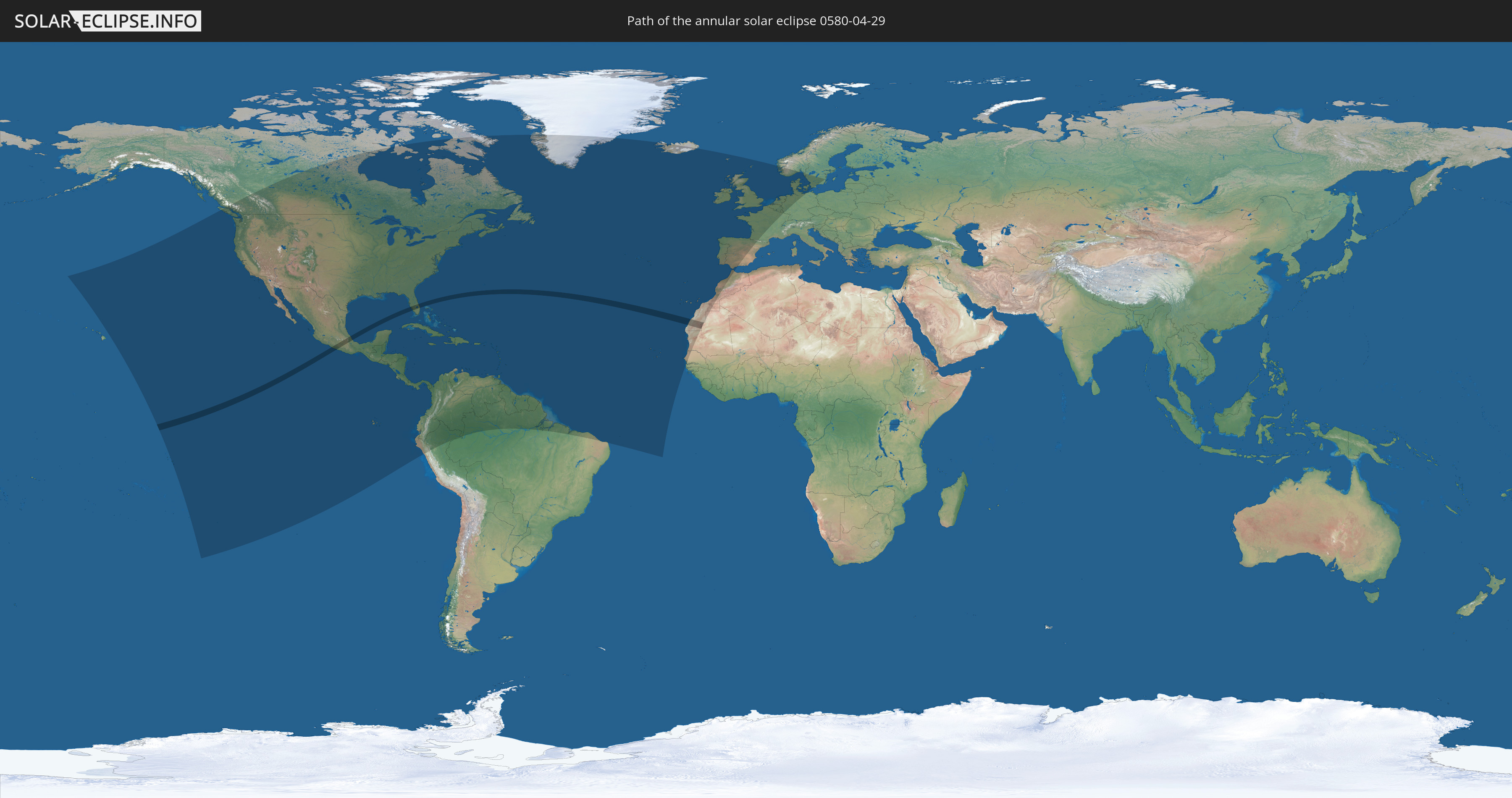
Die Sonnenfinsternis am 04/29/0580 kann man in 72 Ländern als partielle Sonnenfinsternis beobachten.
Der Finsternispfad verläuft durch 3 Länder. Nur in diesen Ländern ist sie als annular Sonnenfinsternis zu sehen.
In den folgenden Ländern ist die Sonnenfinsternis annular zu sehen
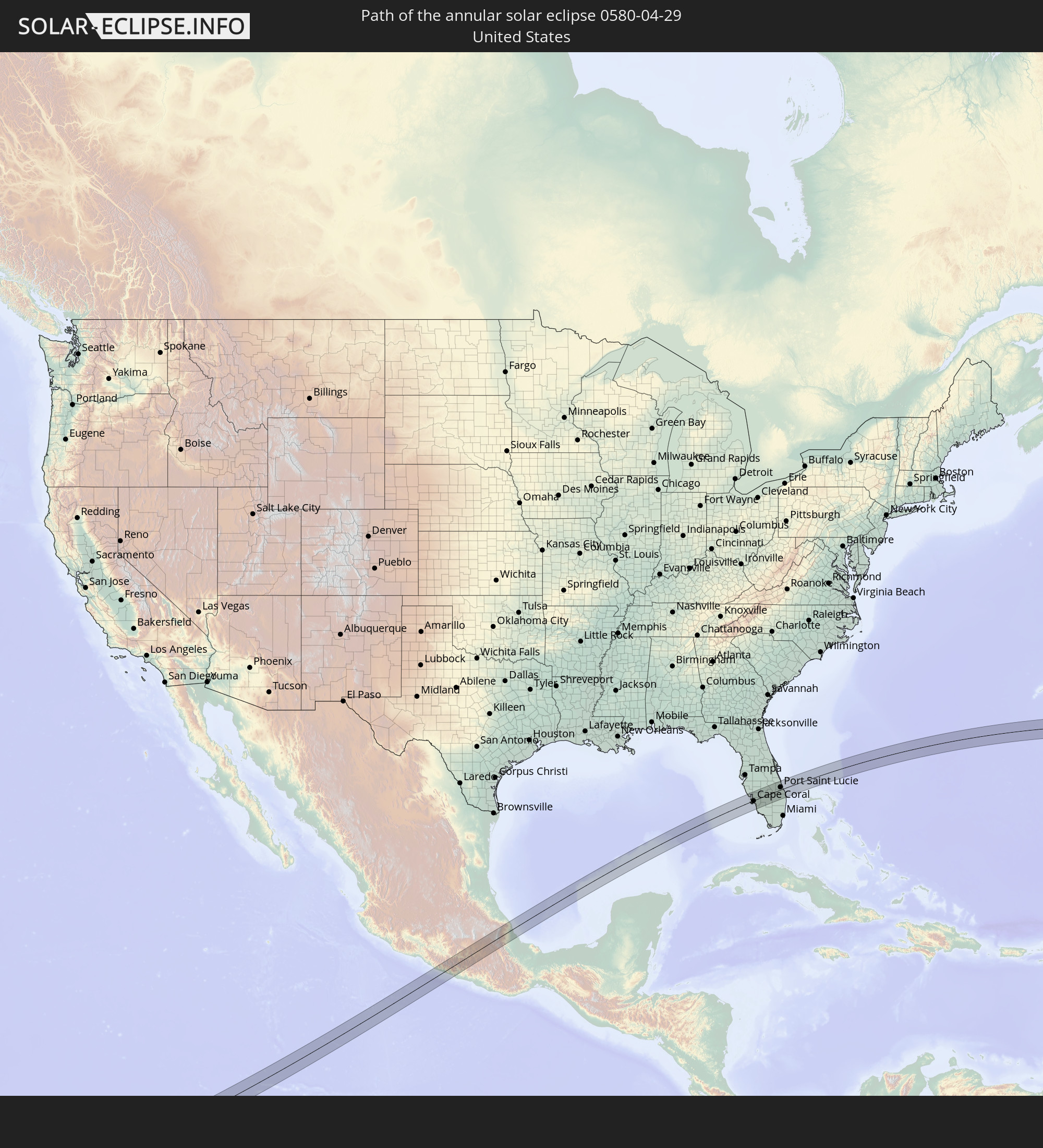 United States
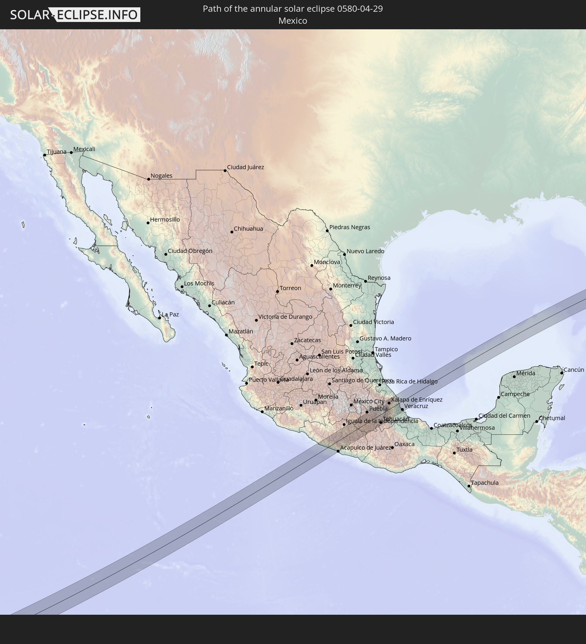 Mexico
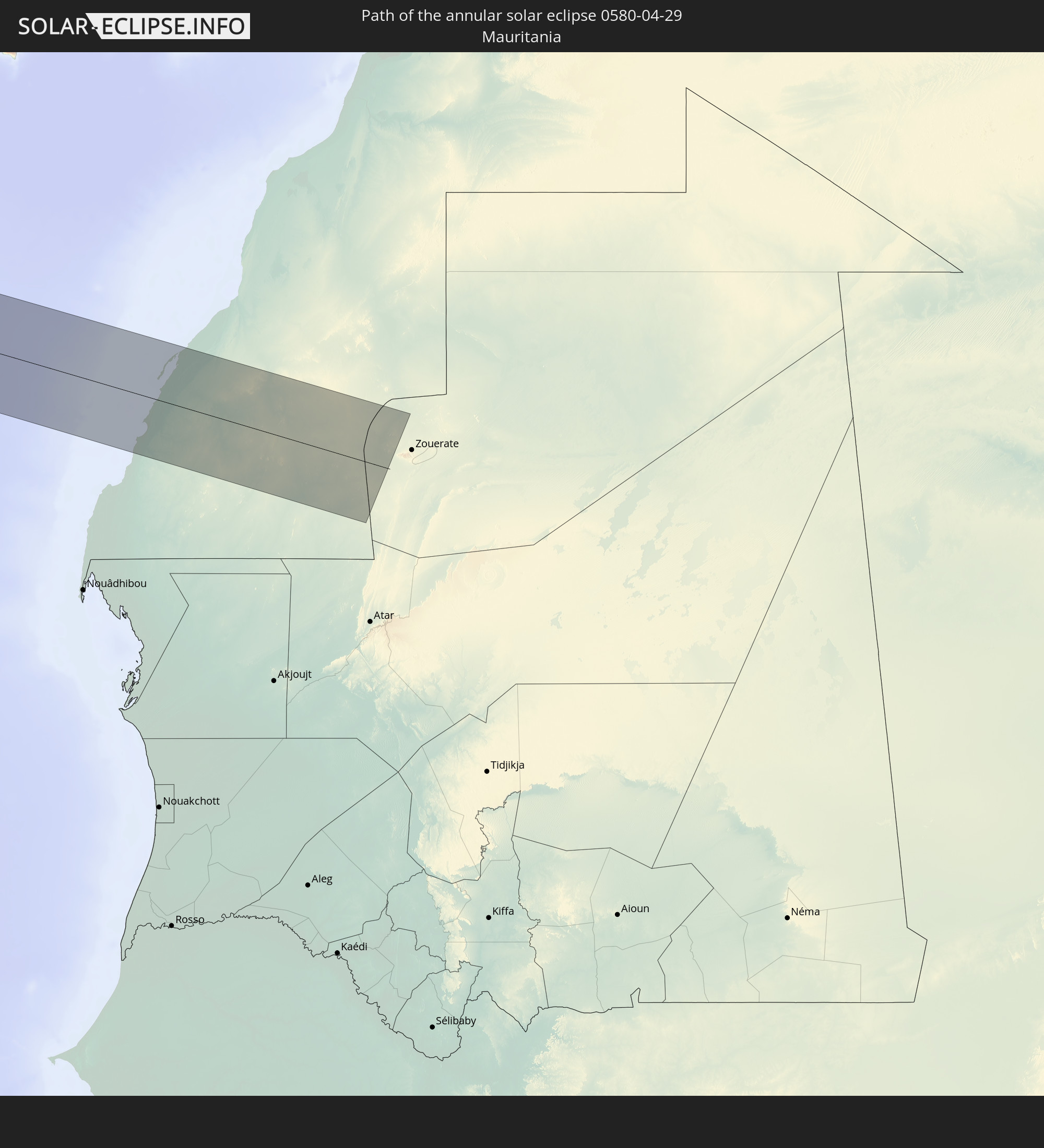 Mauritania
In den folgenden Ländern ist die Sonnenfinsternis partiell zu sehen
 United States
 United States Minor Outlying Islands
 French Polynesia
 Canada
 Pitcairn Islands
 Mexico
 Greenland
 Guatemala
 Ecuador
 El Salvador
 Honduras
 Belize
 Nicaragua
 Costa Rica
 Cuba
Cuba
 Panama
 Colombia
 Cayman Islands
 Peru
Peru
 The Bahamas
 Jamaica
 Haiti
Haiti
 Brazil
 Venezuela
 Turks and Caicos Islands
 Dominican Republic
 Aruba
Aruba
 Puerto Rico
 United States Virgin Islands
 Bermuda
 British Virgin Islands
 Anguilla
 Collectivity of Saint Martin
 Saint Barthélemy
 Saint Kitts and Nevis
 Antigua and Barbuda
 Montserrat
 Trinidad and Tobago
 Guadeloupe
 Grenada
 Dominica
 Saint Vincent and the Grenadines
 Guyana
 Martinique
 Saint Lucia
 Barbados
 Suriname
 Saint Pierre and Miquelon
 French Guiana
 Portugal
 Cabo Verde
 Iceland
 Spain
Spain
 Senegal
 Mauritania
 The Gambia
 Morocco
 Republic of Ireland
 United Kingdom
 Faroe Islands
 Gibraltar
 France
 Isle of Man
 Guernsey
 Jersey
 Belgium
 Netherlands
 Norway
 Luxembourg
 Germany
 Denmark
 Sweden
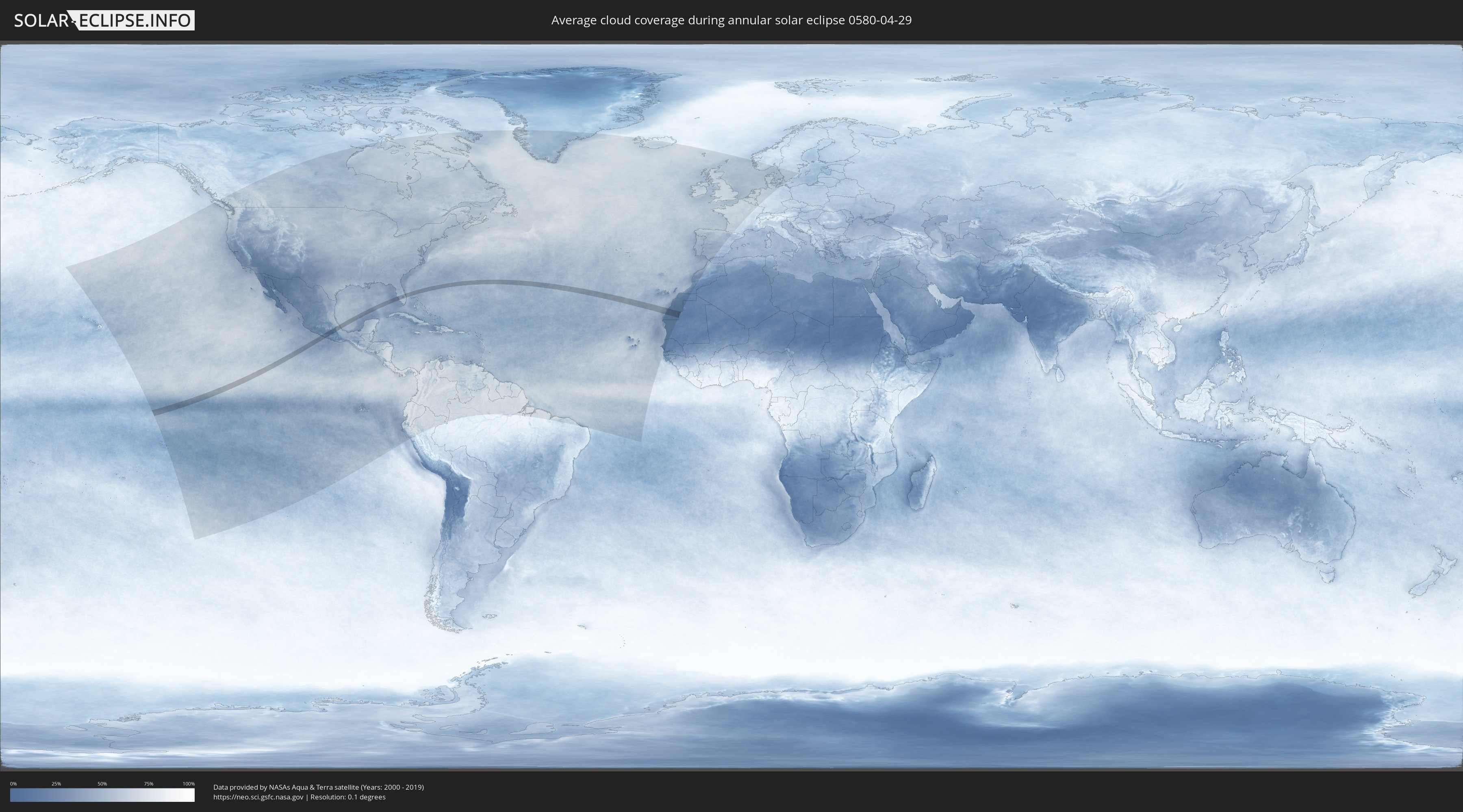
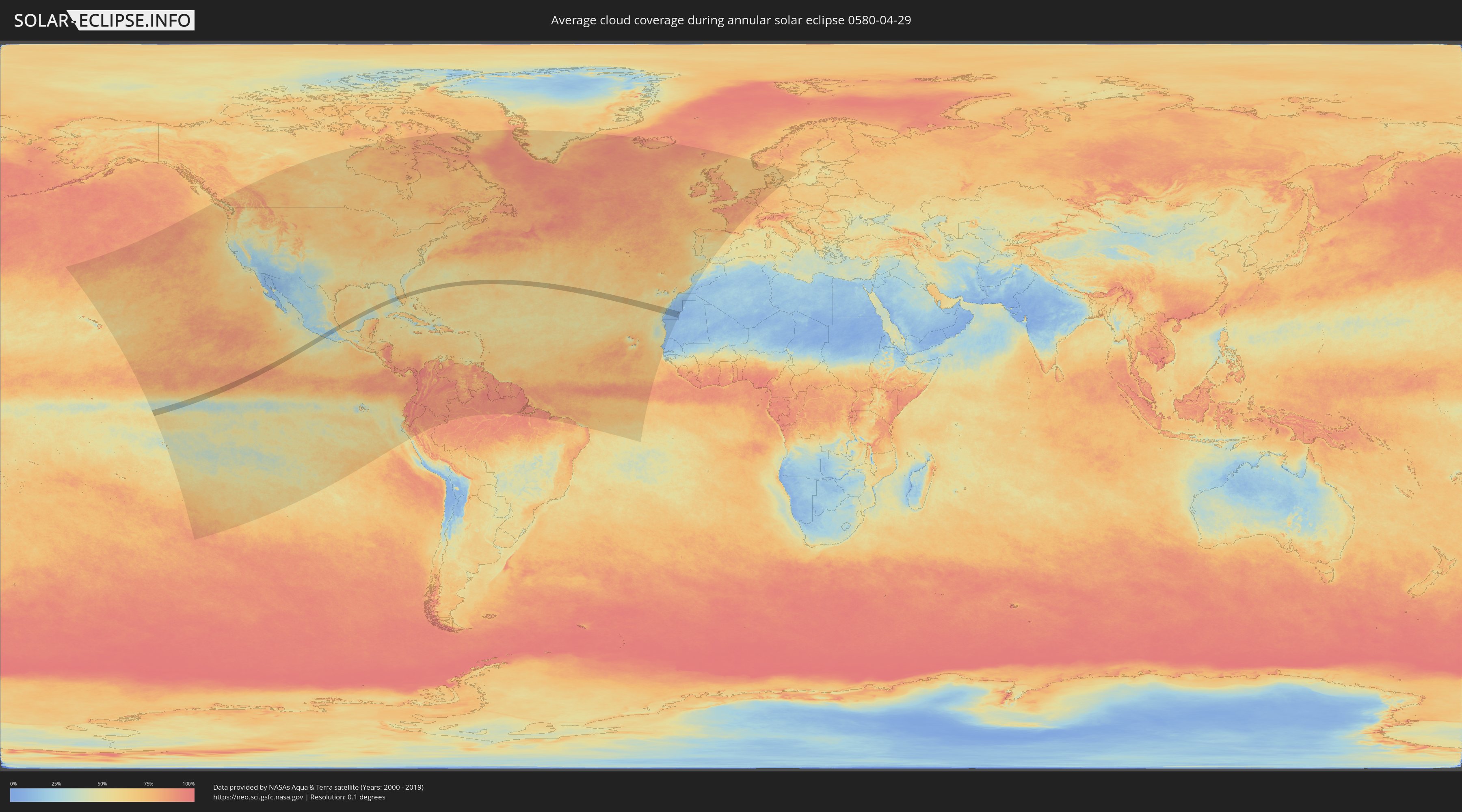
How will be the weather during the annular solar eclipse on 04/29/0580?
Where is the best place to see the annular solar eclipse of 04/29/0580?
The following maps show the average cloud coverage for the day of the annular solar eclipse.
With the help of these maps, it is possible to find the place along the eclipse path, which has the best
chance of a cloudless sky.
Nevertheless, you should consider local circumstances and inform about the weather of your chosen
observation site.
The data is provided by NASAs satellites
AQUA and TERRA.
The cloud maps are averaged over a period of 19 years (2000 - 2019).
Detailed country maps
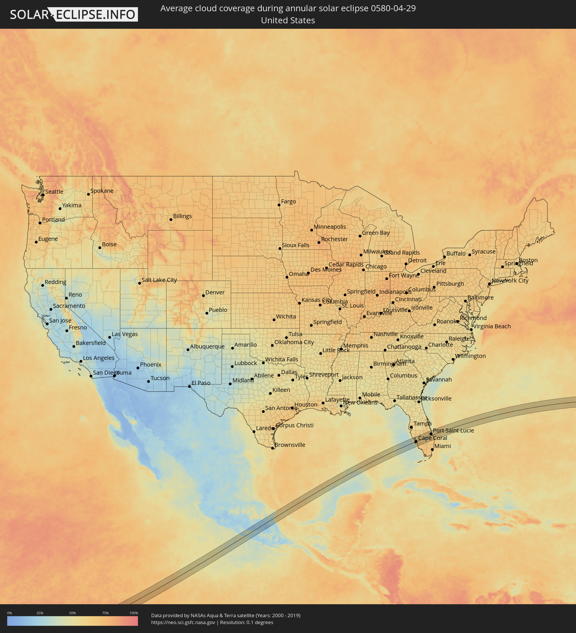 United States
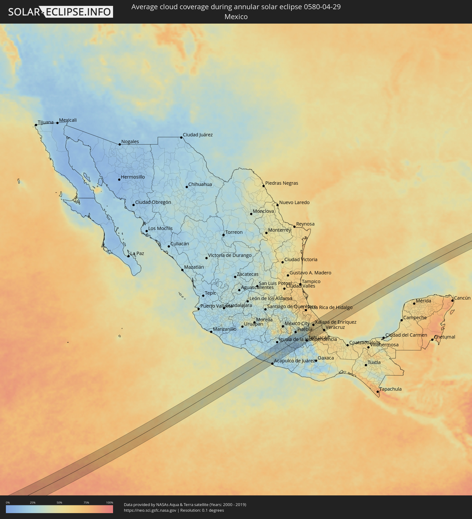 Mexico
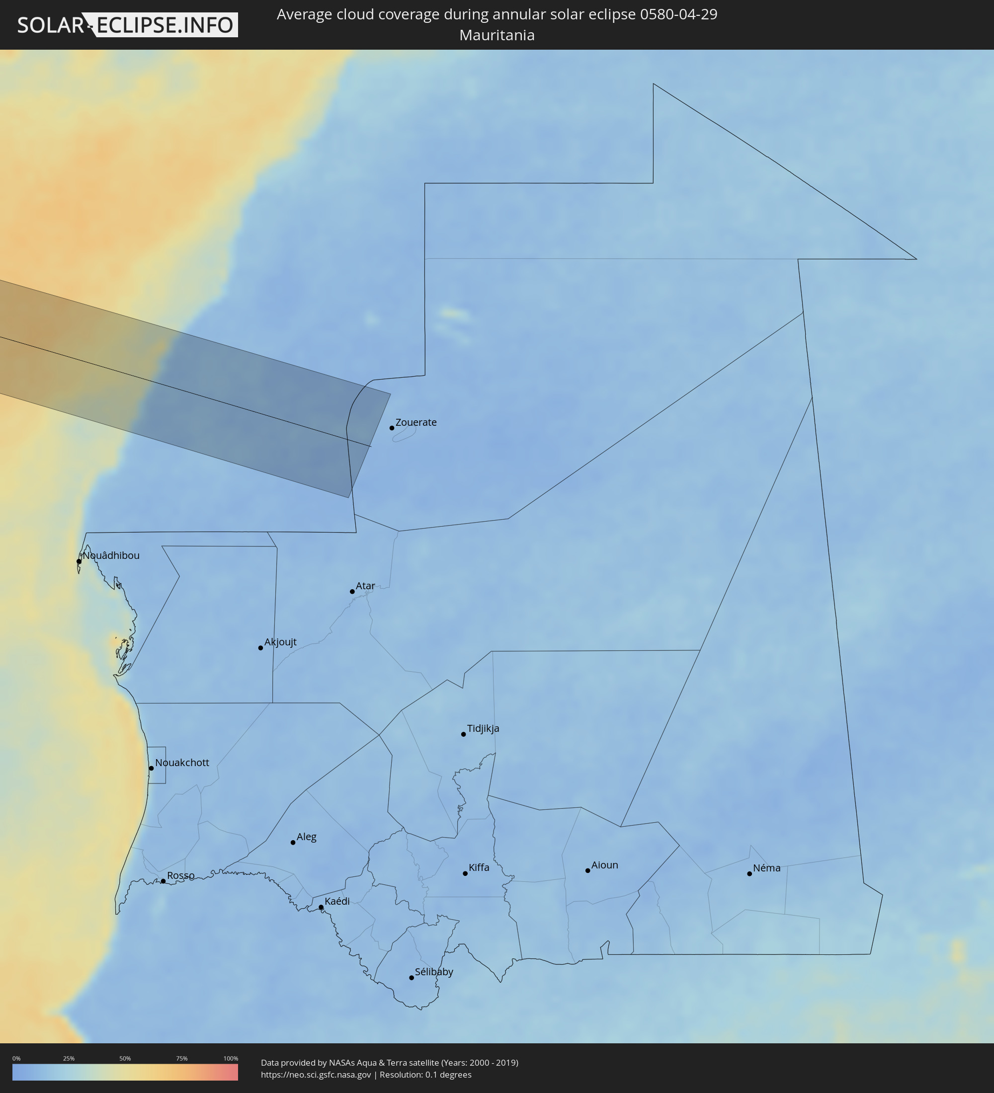 Mauritania
Cities inside the path of the eclipse
The following table shows all locations with a population of more than 5,000 inside the eclipse path. Cities which have more than 100,000 inhabitants are marked bold. A click at the locations opens a detailed map.
| City | Type | Eclipse duration | Local time of max. eclipse | Distance to central line | Ø Cloud coverage |
|
El Súchil, Guerrero
|
annular | - | 09:44:40 UTC-06:36 | 21 km | 36% |
|
Técpan de Galeana, Guerrero
|
annular | - | 09:44:40 UTC-06:36 | 19 km | 36% |
|
San Jerónimo de Juárez, Guerrero
|
annular | - | 09:44:51 UTC-06:36 | 3 km | 43% |
|
Atoyac de Álvarez, Guerrero
|
annular | - | 09:45:03 UTC-06:36 | 7 km | 32% |
|
Coyuca de Benítez, Guerrero
|
annular | - | 09:45:23 UTC-06:36 | 31 km | 39% |
|
Tlacotepec, Guerrero
|
annular | - | 09:47:01 UTC-06:36 | 37 km | 28% |
|
Xaltianguis, Guerrero
|
annular | - | 09:46:19 UTC-06:36 | 44 km | 24% |
|
Chichihualco, Guerrero
|
annular | - | 09:47:25 UTC-06:36 | 7 km | 33% |
|
Tierra Colorada, Guerrero
|
annular | - | 09:46:49 UTC-06:36 | 48 km | 23% |
|
Chilpancingo, Guerrero
|
annular | - | 09:47:34 UTC-06:36 | 13 km | 27% |
|
Atliaca, Guerrero
|
annular | - | 09:48:02 UTC-06:36 | 10 km | 30% |
|
Ciudad de Huitzuco, Guerrero
|
annular | - | 09:49:18 UTC-06:36 | 49 km | 22% |
|
Chilapa de Alvarez, Guerrero
|
annular | - | 09:48:20 UTC-06:36 | 27 km | 22% |
|
Jolalpan, Puebla
|
annular | - | 09:50:23 UTC-06:36 | 24 km | 20% |
|
Axochiapan, Morelos
|
annular | - | 09:50:54 UTC-06:36 | 35 km | 22% |
|
Atencingo, Puebla
|
annular | - | 09:51:14 UTC-06:36 | 28 km | 24% |
|
Chiautla de Tapia, Puebla
|
annular | - | 09:50:51 UTC-06:36 | 8 km | 21% |
|
Ayutla, Puebla
|
annular | - | 09:51:30 UTC-06:36 | 25 km | 25% |
|
Izúcar de Matamoros, Puebla
|
annular | - | 09:51:42 UTC-06:36 | 28 km | 22% |
|
San Andrés Azumiatla, Puebla
|
annular | - | 09:52:43 UTC-06:36 | 45 km | 31% |
|
Acatlán de Osorio, Puebla
|
annular | - | 09:51:52 UTC-06:36 | 32 km | 16% |
|
Amozoc de Mota, Puebla
|
annular | - | 09:53:26 UTC-06:36 | 47 km | 30% |
|
Santiago Acatlán, Puebla
|
annular | - | 09:53:35 UTC-06:36 | 36 km | 29% |
|
Tepeaca, Puebla
|
annular | - | 09:53:36 UTC-06:36 | 32 km | 29% |
|
Santa María Ixtiyucán, Puebla
|
annular | - | 09:54:12 UTC-06:36 | 47 km | 35% |
|
Grajales, Puebla
|
annular | - | 09:54:18 UTC-06:36 | 51 km | 35% |
|
Tecamachalco, Puebla
|
annular | - | 09:53:49 UTC-06:36 | 14 km | 26% |
|
Soltepec, Puebla
|
annular | - | 09:54:19 UTC-06:36 | 36 km | 32% |
|
Santiago Alseseca, Puebla
|
annular | - | 09:53:48 UTC-06:36 | 9 km | 27% |
|
Santa María la Alta, Puebla
|
annular | - | 09:53:28 UTC-06:36 | 17 km | 36% |
|
Villa de El Carmen Tequexquitla, Tlaxcala
|
annular | - | 09:54:48 UTC-06:36 | 52 km | 33% |
|
San Salvador El Seco, Puebla
|
annular | - | 09:54:29 UTC-06:36 | 33 km | 34% |
|
Xaltepec, Puebla
|
annular | - | 09:54:04 UTC-06:36 | 7 km | 29% |
|
San Marcos Tlacoyalco, Puebla
|
annular | - | 09:53:43 UTC-06:36 | 13 km | 29% |
|
Cuacnopalan, Puebla
|
annular | - | 09:54:11 UTC-06:36 | 4 km | 32% |
|
Ciudad Serdán, Puebla
|
annular | - | 09:54:39 UTC-06:36 | 9 km | 37% |
|
Tlachichuca, Puebla
|
annular | - | 09:54:56 UTC-06:36 | 19 km | 43% |
|
San José Esperanza, Puebla
|
annular | - | 09:54:30 UTC-06:36 | 6 km | 31% |
|
Tehuacán, Puebla
|
annular | - | 09:53:48 UTC-06:36 | 44 km | 26% |
|
Tlanalapan, Puebla
|
annular | - | 09:55:31 UTC-06:36 | 24 km | 46% |
|
Maltrata, Veracruz
|
annular | - | 09:54:42 UTC-06:36 | 18 km | 39% |
|
Perote, Veracruz
|
annular | - | 09:56:10 UTC-06:36 | 51 km | 46% |
|
Unión y Progreso, Veracruz
|
annular | - | 09:55:10 UTC-06:36 | 21 km | 56% |
|
Orizaba, Veracruz
|
annular | - | 09:55:10 UTC-06:36 | 24 km | 56% |
|
Las Vigas de Ramírez, Veracruz
|
annular | - | 09:56:37 UTC-06:36 | 51 km | 55% |
|
Atzacan, Veracruz
|
annular | - | 09:55:19 UTC-06:36 | 19 km | 56% |
|
Rafael Delgado, Veracruz
|
annular | - | 09:55:09 UTC-06:36 | 29 km | 55% |
|
Chocaman, Veracruz
|
annular | - | 09:55:37 UTC-06:36 | 12 km | 56% |
|
Cuautlapán, Veracruz
|
annular | - | 09:55:23 UTC-06:36 | 25 km | 54% |
|
Monte Blanco, Veracruz
|
annular | - | 09:55:34 UTC-06:36 | 17 km | 56% |
|
Xico, Veracruz
|
annular | - | 09:56:26 UTC-06:36 | 25 km | 57% |
|
Zongolica, Veracruz
|
annular | - | 09:55:04 UTC-06:36 | 47 km | 57% |
|
Huatusco de Chicuellar, Veracruz
|
annular | - | 09:56:01 UTC-06:36 | 3 km | 59% |
|
Córdoba, Veracruz
|
annular | - | 09:55:37 UTC-06:36 | 30 km | 53% |
|
Xalapa de Enríquez, Veracruz
|
annular | - | 09:56:50 UTC-06:36 | 31 km | 56% |
|
Amatlán de los Reyes, Veracruz
|
annular | - | 09:55:35 UTC-06:36 | 34 km | 57% |
|
Lomas Verdes, Veracruz
|
annular | - | 09:56:51 UTC-06:36 | 26 km | 56% |
|
Naolinco de Victoria, Veracruz
|
annular | - | 09:57:10 UTC-06:36 | 40 km | 56% |
|
Cuichapa, Veracruz
|
annular | - | 09:55:33 UTC-06:36 | 44 km | 57% |
|
Tuzamapan, Veracruz
|
annular | - | 09:56:43 UTC-06:36 | 15 km | 54% |
|
Paso del Macho, Veracruz
|
annular | - | 09:56:15 UTC-06:36 | 33 km | 57% |
|
Cuitláhuac, Veracruz
|
annular | - | 09:55:57 UTC-06:36 | 48 km | 54% |
|
Rinconada, Veracruz
|
annular | - | 09:57:19 UTC-06:36 | 6 km | 57% |
|
Paso de Ovejas, Veracruz
|
annular | - | 09:57:28 UTC-06:36 | 19 km | 56% |
|
Soledad de Doblado, Veracruz
|
annular | - | 09:57:04 UTC-06:36 | 43 km | 62% |
|
Villa Zempoala, Veracruz
|
annular | - | 09:57:50 UTC-06:36 | 6 km | 53% |
|
Veracruz, Veracruz
|
annular | - | 09:57:58 UTC-06:36 | 45 km | 59% |
|
Rotonda, Florida
|
annular | - | 12:24:38 UTC-05:00 | 43 km | 50% |
|
Port Charlotte, Florida
|
annular | - | 12:25:20 UTC-05:00 | 44 km | 57% |
|
Punta Gorda Isles, Florida
|
annular | - | 12:25:17 UTC-05:00 | 38 km | 58% |
|
Punta Gorda, Florida
|
annular | - | 12:25:24 UTC-05:00 | 38 km | 60% |
|
Sanibel, Florida
|
annular | - | 12:24:51 UTC-05:00 | 12 km | 39% |
|
Iona, Florida
|
annular | - | 12:25:07 UTC-05:00 | 7 km | 49% |
|
Fort Myers Beach, Florida
|
annular | - | 12:25:04 UTC-05:00 | 15 km | 49% |
|
Cape Coral, Florida
|
annular | - | 12:25:12 UTC-05:00 | 4 km | 59% |
|
McGregor, Florida
|
annular | - | 12:25:18 UTC-05:00 | 5 km | 59% |
|
Cypress Lake, Florida
|
annular | - | 12:25:19 UTC-05:00 | 8 km | 58% |
|
North Fort Myers, Florida
|
annular | - | 12:25:33 UTC-05:00 | 5 km | 60% |
|
Villas, Florida
|
annular | - | 12:25:26 UTC-05:00 | 8 km | 59% |
|
Fort Myers, Florida
|
annular | - | 12:25:36 UTC-05:00 | 2 km | 63% |
|
Naples Park, Florida
|
annular | - | 12:25:14 UTC-05:00 | 40 km | 60% |
|
Estero, Florida
|
annular | - | 12:25:28 UTC-05:00 | 22 km | 61% |
|
Pelican Bay, Florida
|
annular | - | 12:25:12 UTC-05:00 | 43 km | 58% |
|
San Carlos Park, Florida
|
annular | - | 12:25:31 UTC-05:00 | 19 km | 63% |
|
Bonita Springs, Florida
|
annular | - | 12:25:25 UTC-05:00 | 33 km | 60% |
|
Gateway, Florida
|
annular | - | 12:25:48 UTC-05:00 | 10 km | 63% |
|
Fort Myers Shores, Florida
|
annular | - | 12:25:59 UTC-05:00 | 4 km | 66% |
|
Lehigh Acres, Florida
|
annular | - | 12:26:14 UTC-05:00 | 9 km | 64% |
|
Immokalee, Florida
|
annular | - | 12:26:35 UTC-05:00 | 39 km | 66% |
|
Clewiston, Florida
|
annular | - | 12:28:25 UTC-05:00 | 22 km | 54% |
|
Okeechobee, Florida
|
annular | - | 12:29:19 UTC-05:00 | 25 km | 48% |
|
Belle Glade, Florida
|
annular | - | 12:29:07 UTC-05:00 | 39 km | 63% |
|
Pahokee, Florida
|
annular | - | 12:29:17 UTC-05:00 | 25 km | 60% |
|
Indiantown, Florida
|
annular | - | 12:30:04 UTC-05:00 | 10 km | 65% |
|
Vero Beach South, Florida
|
annular | - | 12:30:58 UTC-05:00 | 49 km | 60% |
|
Lakewood Park, Florida
|
annular | - | 12:30:55 UTC-05:00 | 41 km | 61% |
|
Vero Beach, Florida
|
annular | - | 12:31:02 UTC-05:00 | 51 km | 60% |
|
Florida Ridge, Florida
|
annular | - | 12:31:00 UTC-05:00 | 44 km | 60% |
|
Lakewood Park, Florida
|
annular | - | 12:30:55 UTC-05:00 | 34 km | 61% |
|
Fort Pierce North, Florida
|
annular | - | 12:30:57 UTC-05:00 | 32 km | 61% |
|
Fort Pierce South, Florida
|
annular | - | 12:30:54 UTC-05:00 | 25 km | 63% |
|
Port Saint Lucie, Florida
|
annular | - | 12:30:46 UTC-05:00 | 13 km | 65% |
|
River Park, Florida
|
annular | - | 12:30:48 UTC-05:00 | 15 km | 61% |
|
Fort Pierce, Florida
|
annular | - | 12:31:01 UTC-05:00 | 28 km | 60% |
|
Indian River Estates, Florida
|
annular | - | 12:30:58 UTC-05:00 | 19 km | 60% |
|
Palm City, Florida
|
annular | - | 12:30:52 UTC-05:00 | 3 km | 66% |
|
Stuart, Florida
|
annular | - | 12:30:57 UTC-05:00 | 0 km | 66% |
|
Jensen Beach, Florida
|
annular | - | 12:31:05 UTC-05:00 | 5 km | 60% |
|
Hutchinson Island South, Florida
|
annular | - | 12:31:09 UTC-05:00 | 9 km | 60% |
|
Port Salerno, Florida
|
annular | - | 12:31:02 UTC-05:00 | 8 km | 65% |
|
Palm Beach Gardens, Florida
|
annular | - | 12:30:51 UTC-05:00 | 43 km | 65% |
|
Hobe Sound, Florida
|
annular | - | 12:31:08 UTC-05:00 | 19 km | 58% |
|
Tequesta, Florida
|
annular | - | 12:31:03 UTC-05:00 | 29 km | 60% |
|
Jupiter, Florida
|
annular | - | 12:31:06 UTC-05:00 | 33 km | 64% |
|
North Palm Beach, Florida
|
annular | - | 12:31:00 UTC-05:00 | 46 km | 65% |
|
Lake Park, Florida
|
annular | - | 12:31:02 UTC-05:00 | 48 km | 65% |
 Dakhla, Oued Ed-Dahab-Lagouira
|
annular | - | 18:19:09 UTC-00:52 | 34 km | 45% |