Annular solar eclipse of 01/16/0595
| Day of week: | Friday |
| Maximum duration of eclipse: | 08m20s |
| Maximum width of eclipse path: | 253 km |
| Saros cycle: | 89 |
| Coverage: | 93.2% |
| Magnitude: | 0.9324 |
| Gamma: | 0.0214 |
Wo kann man die Sonnenfinsternis vom 01/16/0595 sehen?
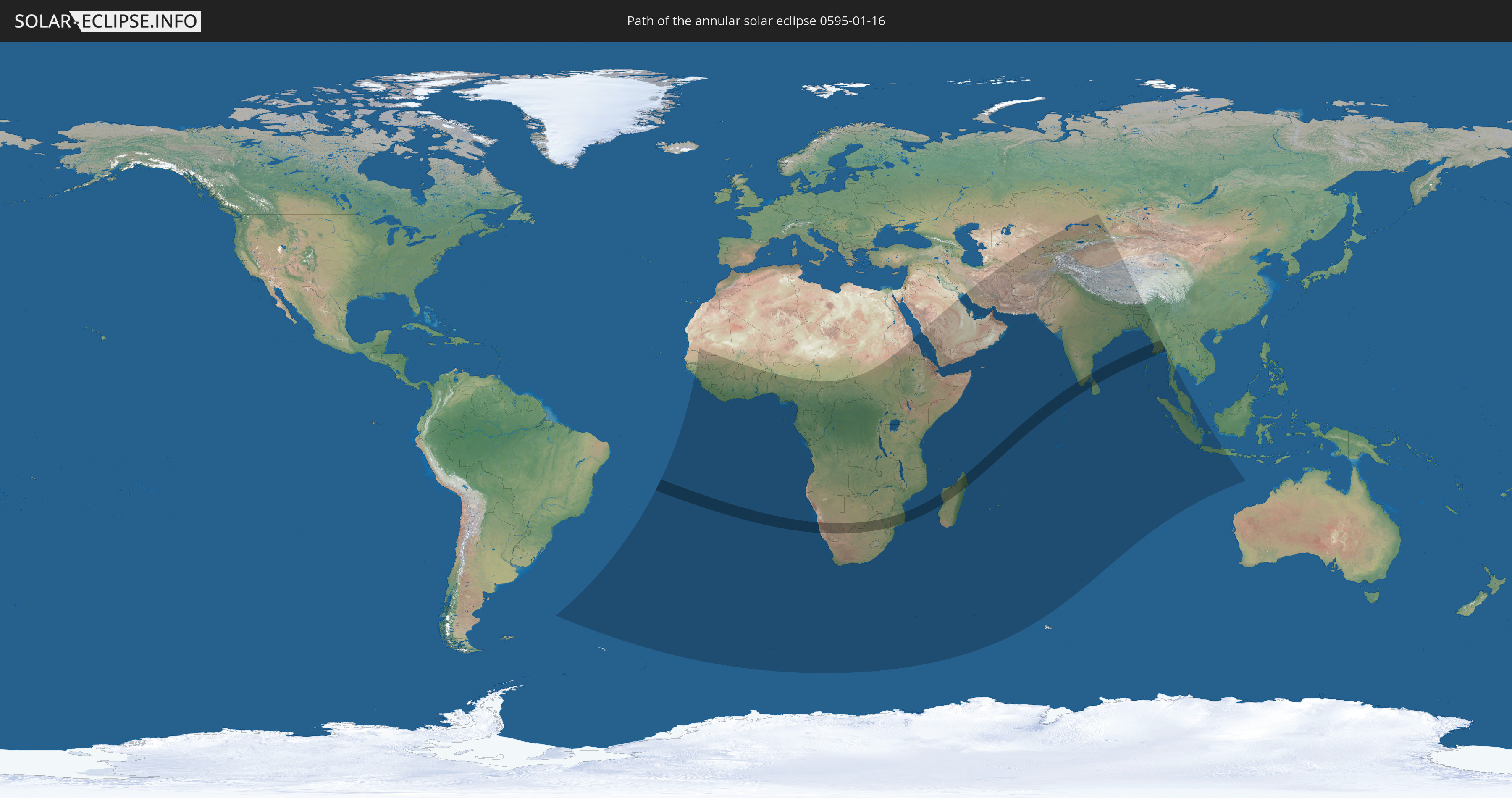
Die Sonnenfinsternis am 01/16/0595 kann man in 81 Ländern als partielle Sonnenfinsternis beobachten.
Der Finsternispfad verläuft durch 9 Länder. Nur in diesen Ländern ist sie als annular Sonnenfinsternis zu sehen.
In den folgenden Ländern ist die Sonnenfinsternis annular zu sehen
 Namibia
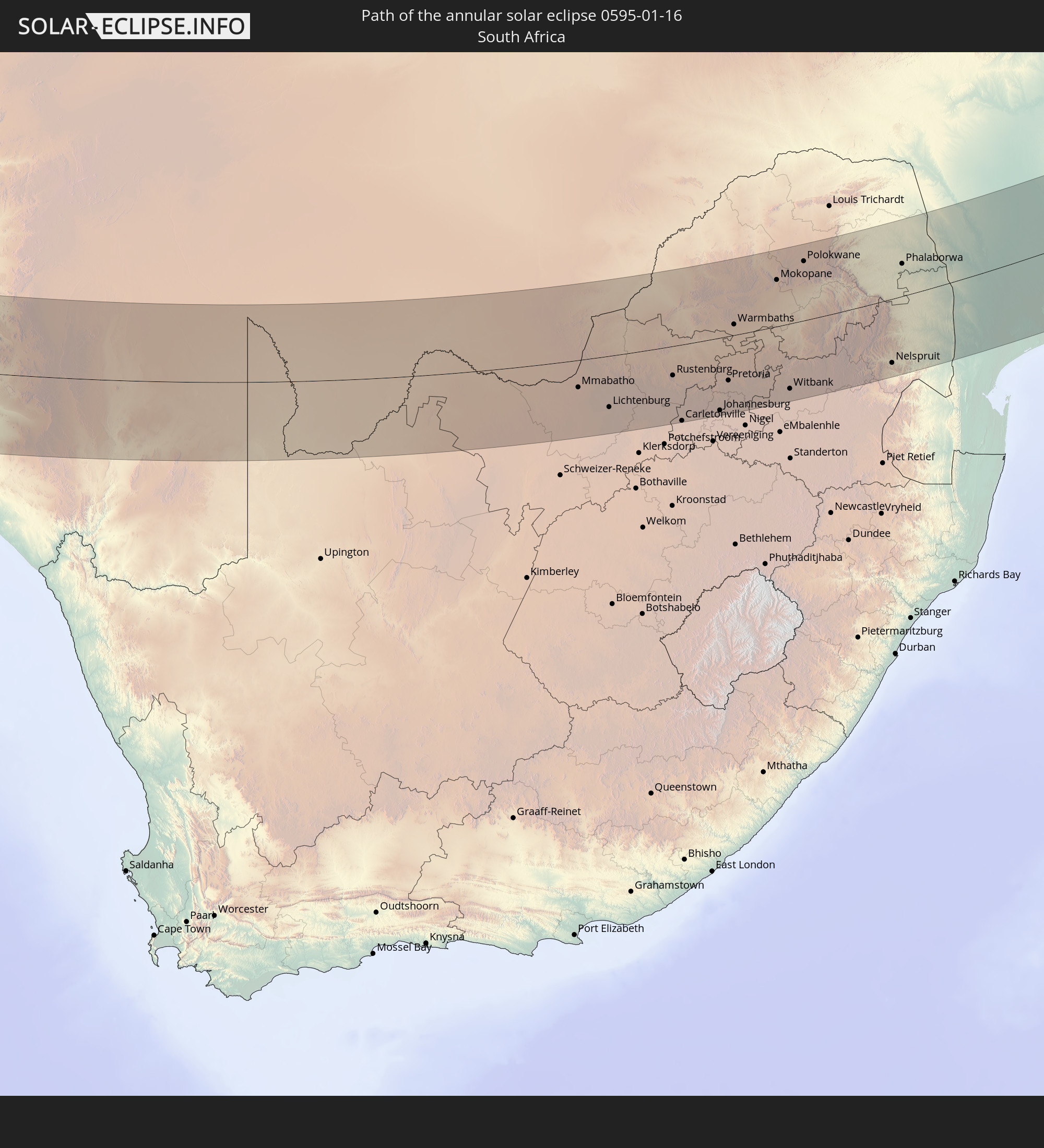 South Africa
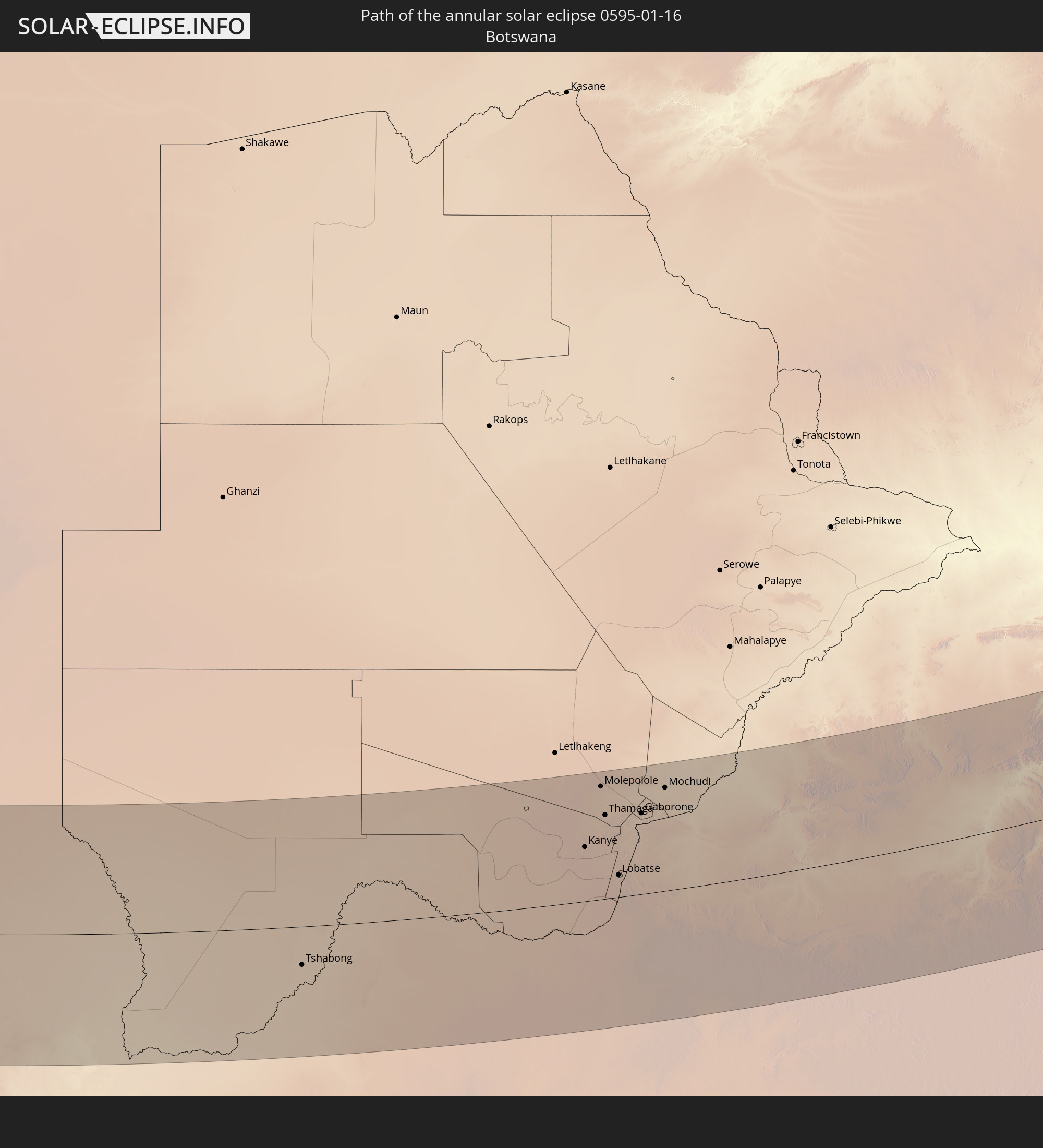 Botswana
 Mozambique
 Madagascar
 India
India
 Maldives
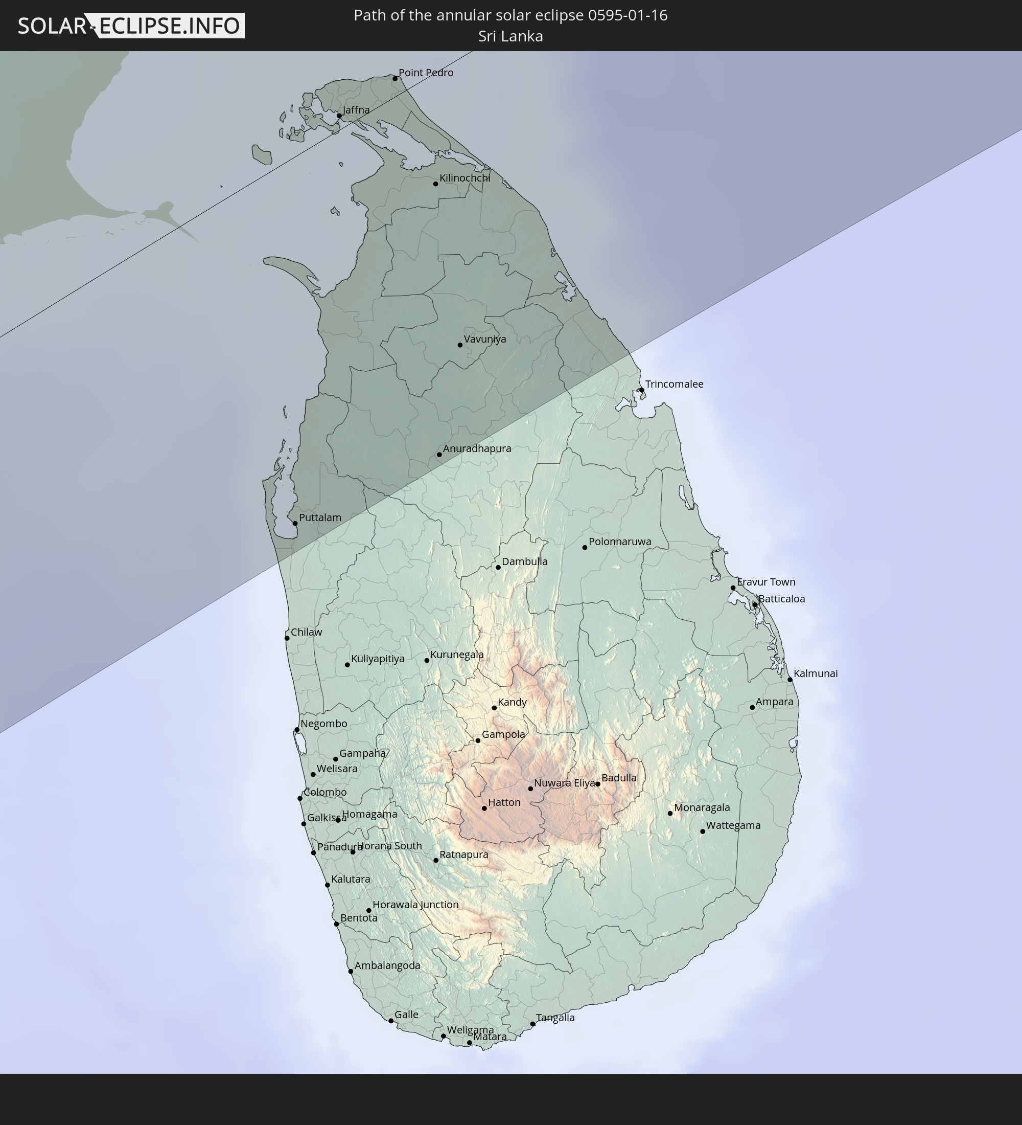 Sri Lanka
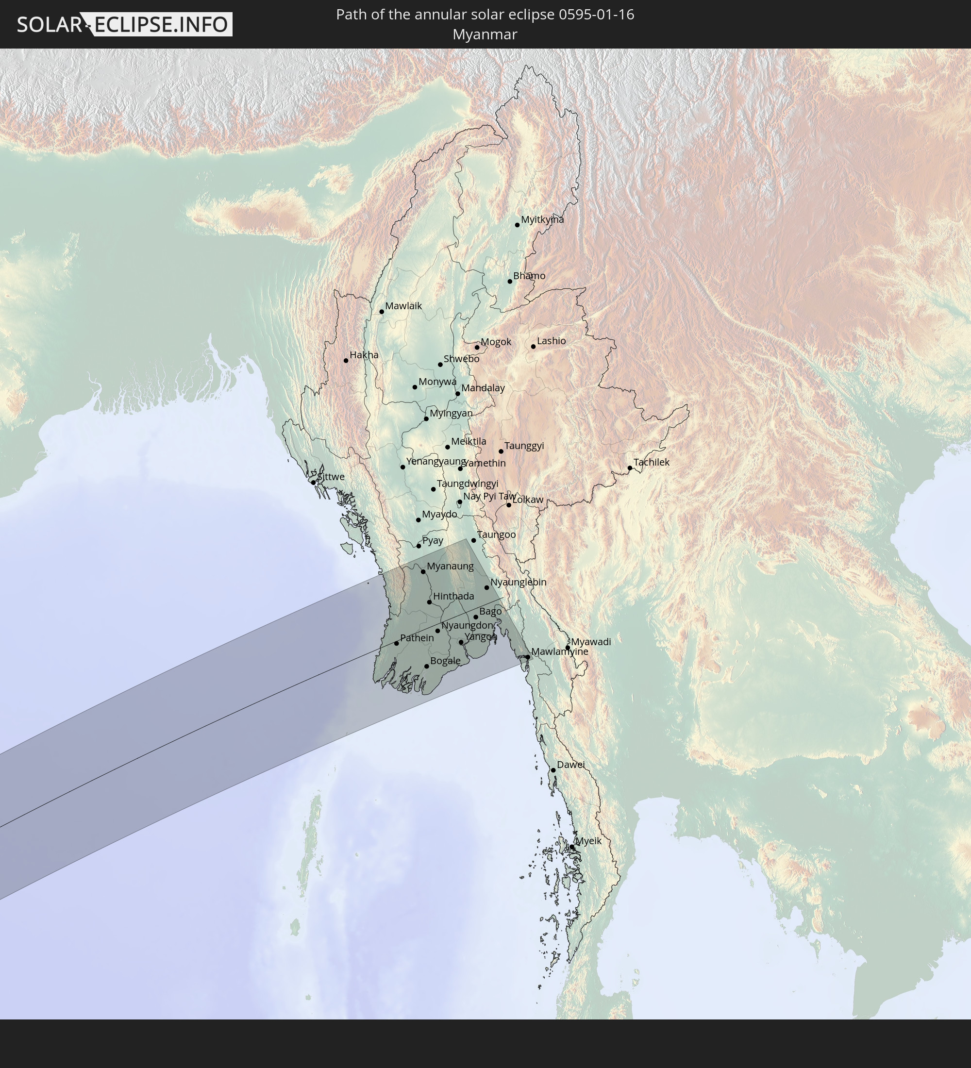 Myanmar
In den folgenden Ländern ist die Sonnenfinsternis partiell zu sehen
 Senegal
 Mauritania
 The Gambia
 Guinea-Bissau
 Guinea
 Saint Helena, Ascension and Tristan da Cunha
 Sierra Leone
 Mali
Mali
 Liberia
 Ivory Coast
 Burkina Faso
 Ghana
Ghana
 Togo
Togo
 Benin
Benin
 Nigeria
 Bouvet Island
 Equatorial Guinea
 São Tomé and Príncipe
 Cameroon
 Gabon
Gabon
 Republic of the Congo
 Angola
 Namibia
 Democratic Republic of the Congo
 Chad
Chad
 Central African Republic
 South Africa
 Botswana
 Sudan
Sudan
 Zambia
 Zimbabwe
 Lesotho
 Rwanda
 Burundi
 Tanzania
 Uganda
 Mozambique
 Swaziland
 Malawi
 Ethiopia
 Kenya
Kenya
 Saudi Arabia
 Eritrea
 French Southern and Antarctic Lands
 Somalia
 Djibouti
 Yemen
Yemen
 Madagascar
 Comoros
 Iran
Iran
 Mayotte
 Seychelles
 Kazakhstan
 Kuwait
 Bahrain
 Qatar
Qatar
 United Arab Emirates
 Oman
Oman
 Turkmenistan
 Réunion
 Uzbekistan
 Mauritius
 Afghanistan
 Pakistan
 Tajikistan
 India
India
 Kyrgyzstan
 British Indian Ocean Territory
 Maldives
 China
China
 Sri Lanka
 Nepal
Nepal
 Bangladesh
 Bhutan
 Myanmar
 Indonesia
 Cocos Islands
 Thailand
 Malaysia
 Singapore
 Christmas Island
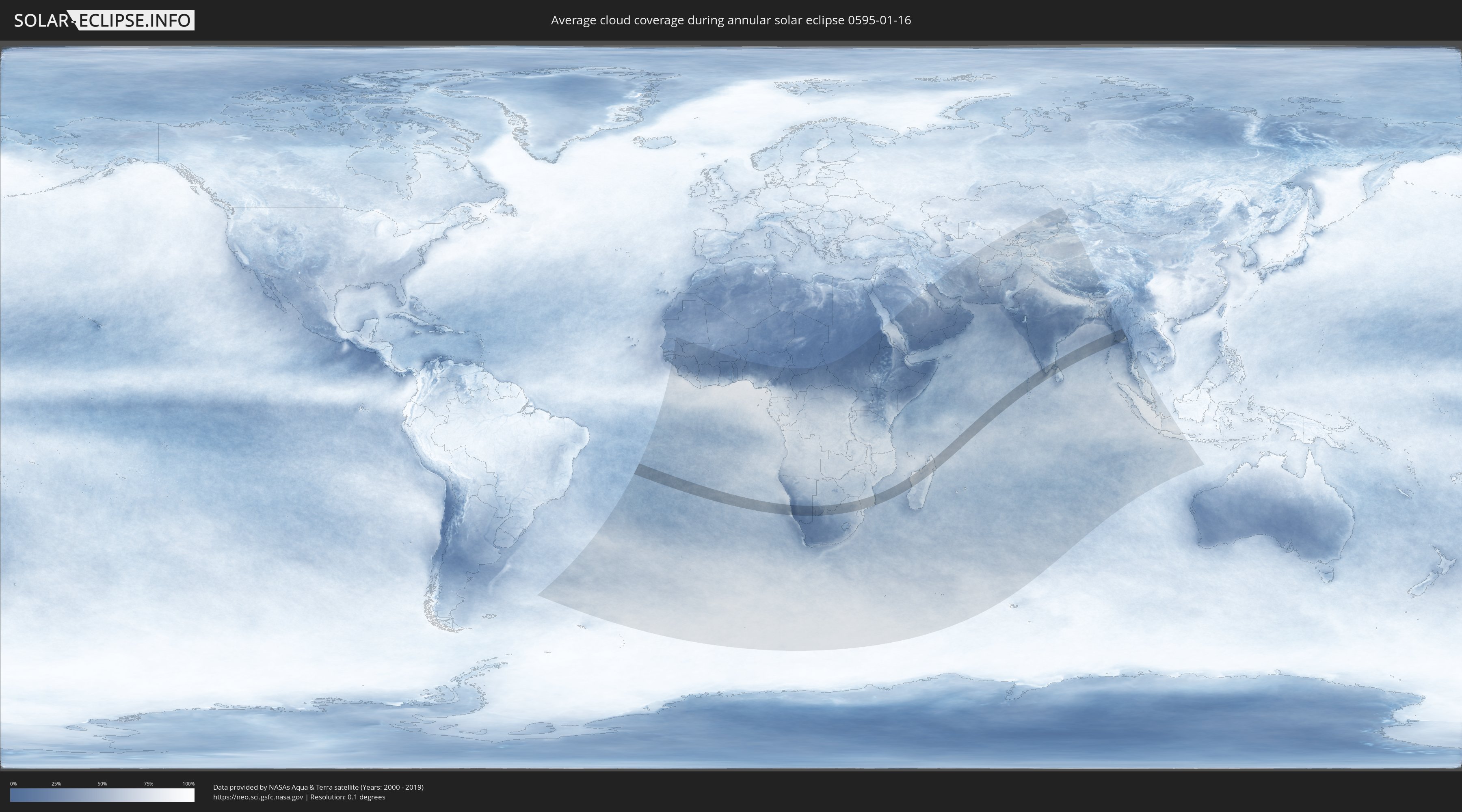
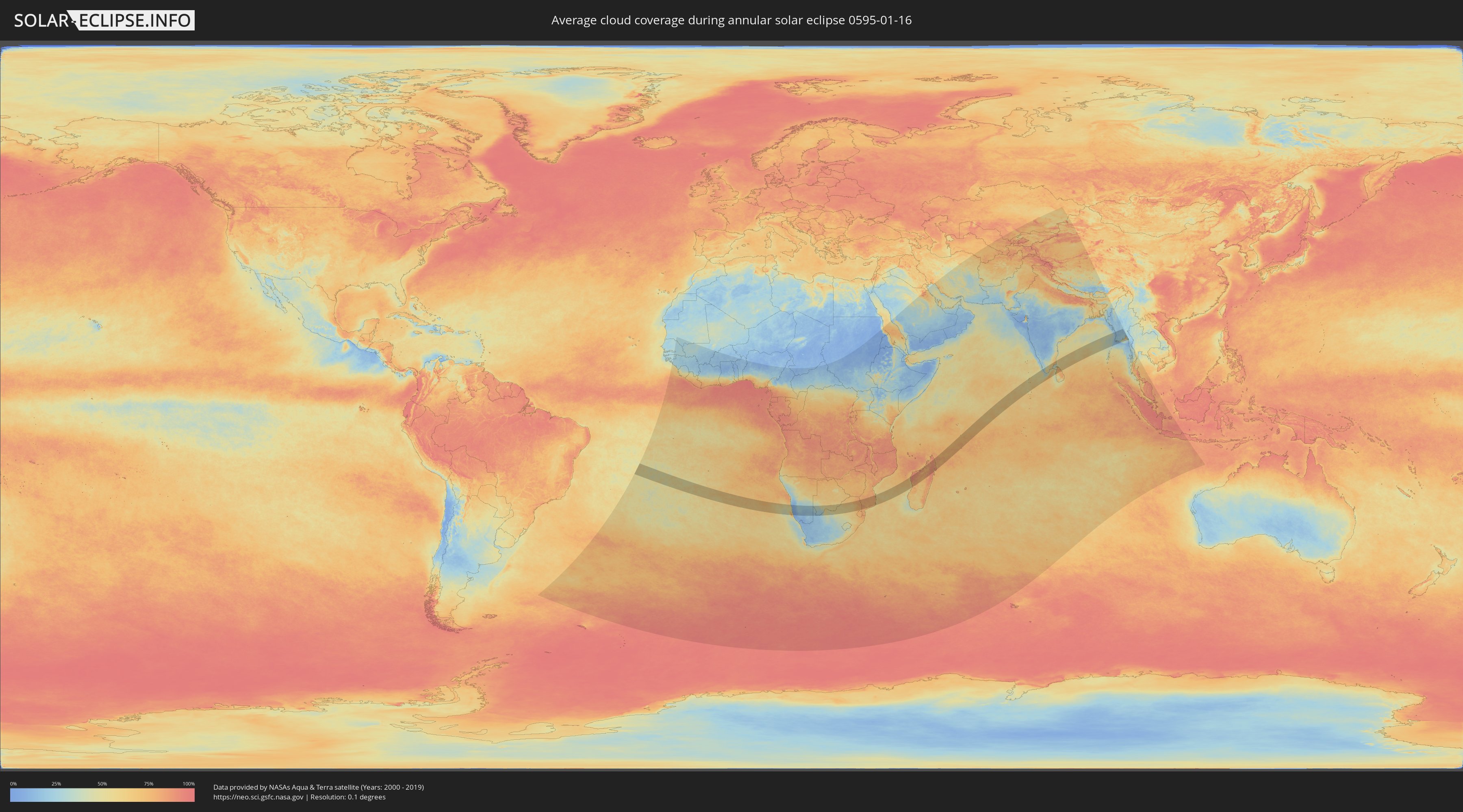
How will be the weather during the annular solar eclipse on 01/16/0595?
Where is the best place to see the annular solar eclipse of 01/16/0595?
The following maps show the average cloud coverage for the day of the annular solar eclipse.
With the help of these maps, it is possible to find the place along the eclipse path, which has the best
chance of a cloudless sky.
Nevertheless, you should consider local circumstances and inform about the weather of your chosen
observation site.
The data is provided by NASAs satellites
AQUA and TERRA.
The cloud maps are averaged over a period of 19 years (2000 - 2019).
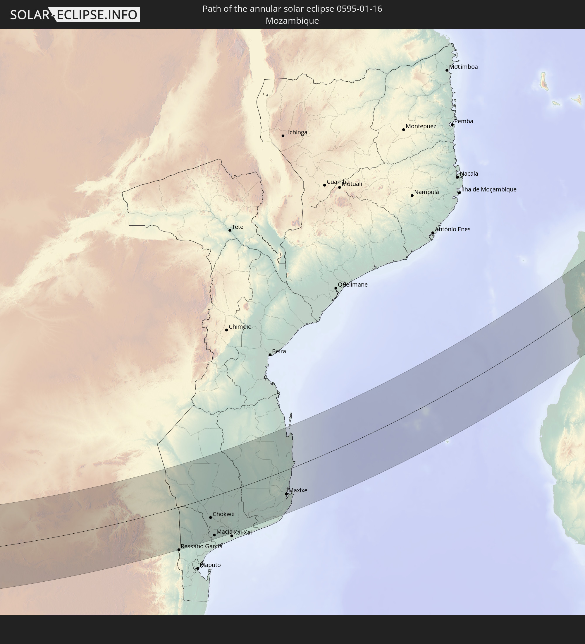
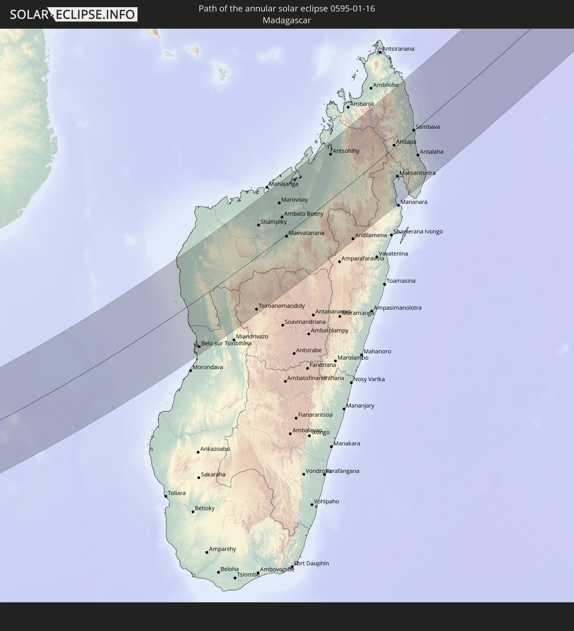
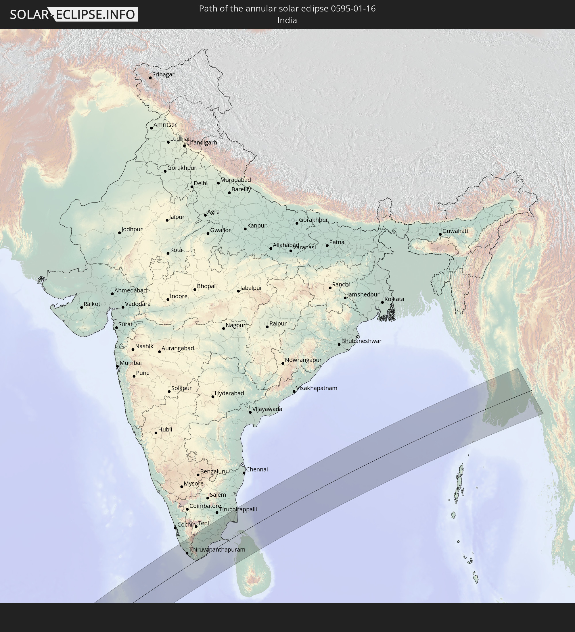
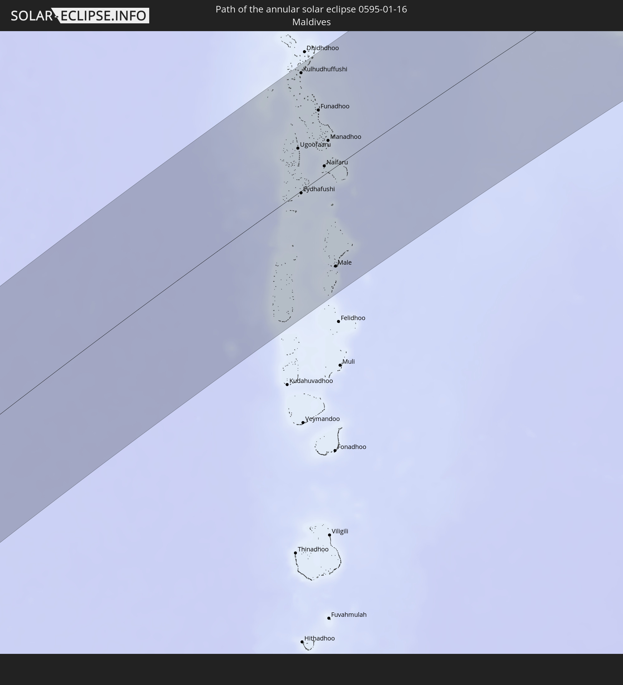
Detailed country maps
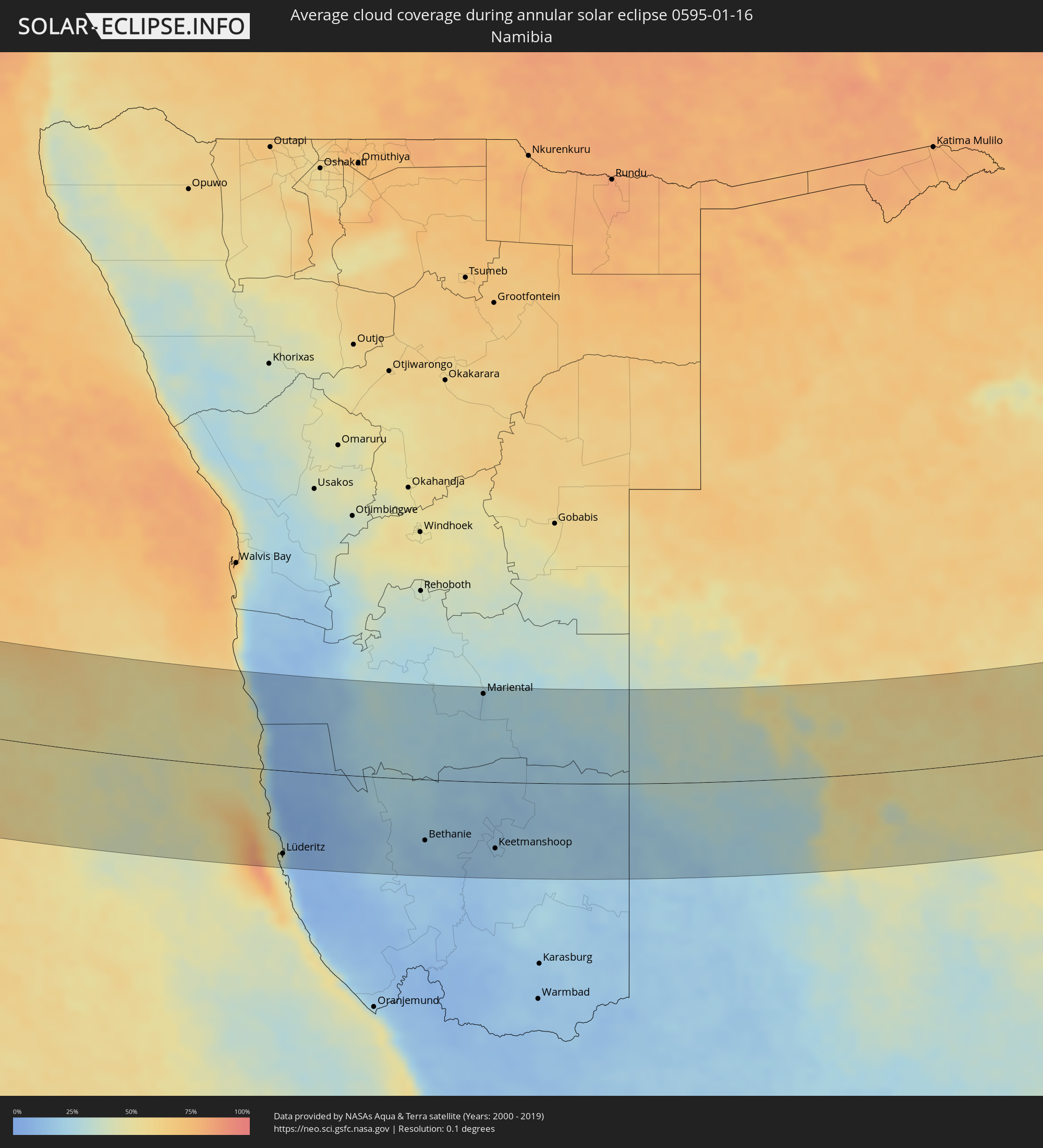 Namibia
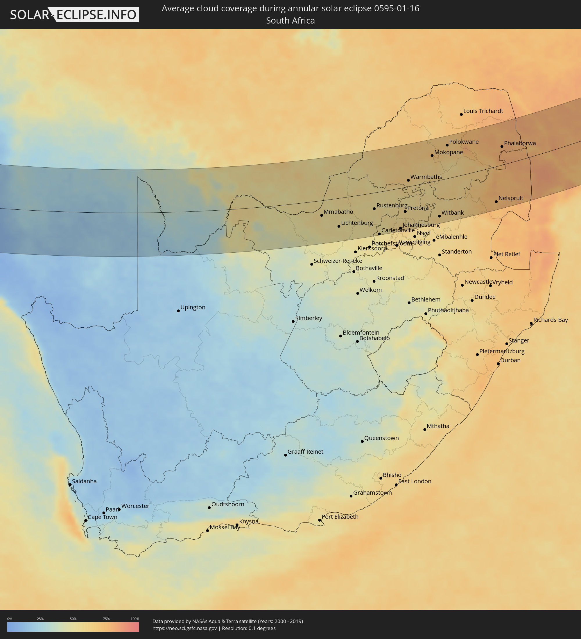 South Africa
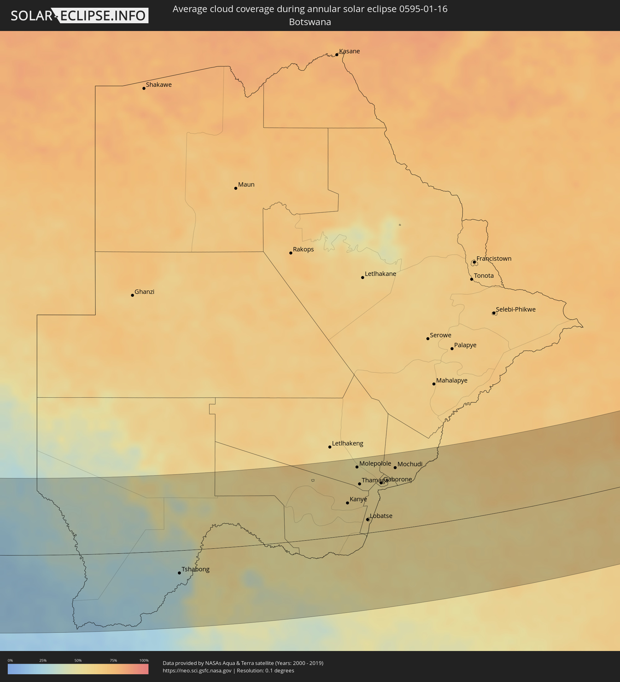 Botswana
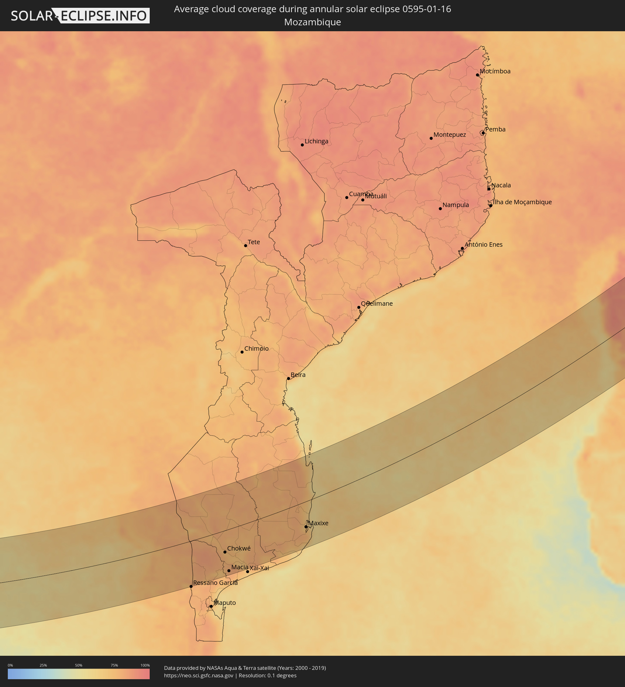 Mozambique
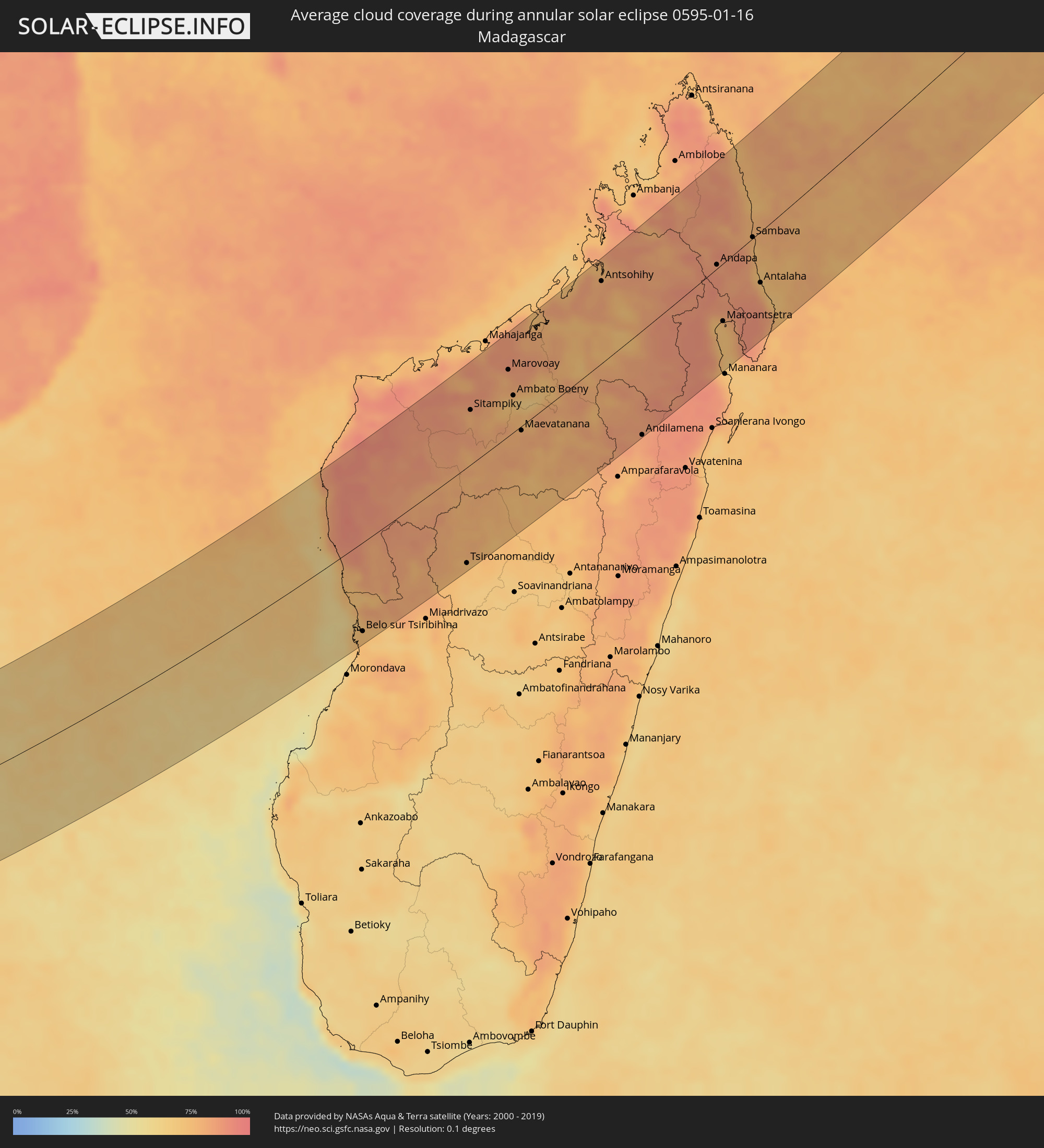 Madagascar
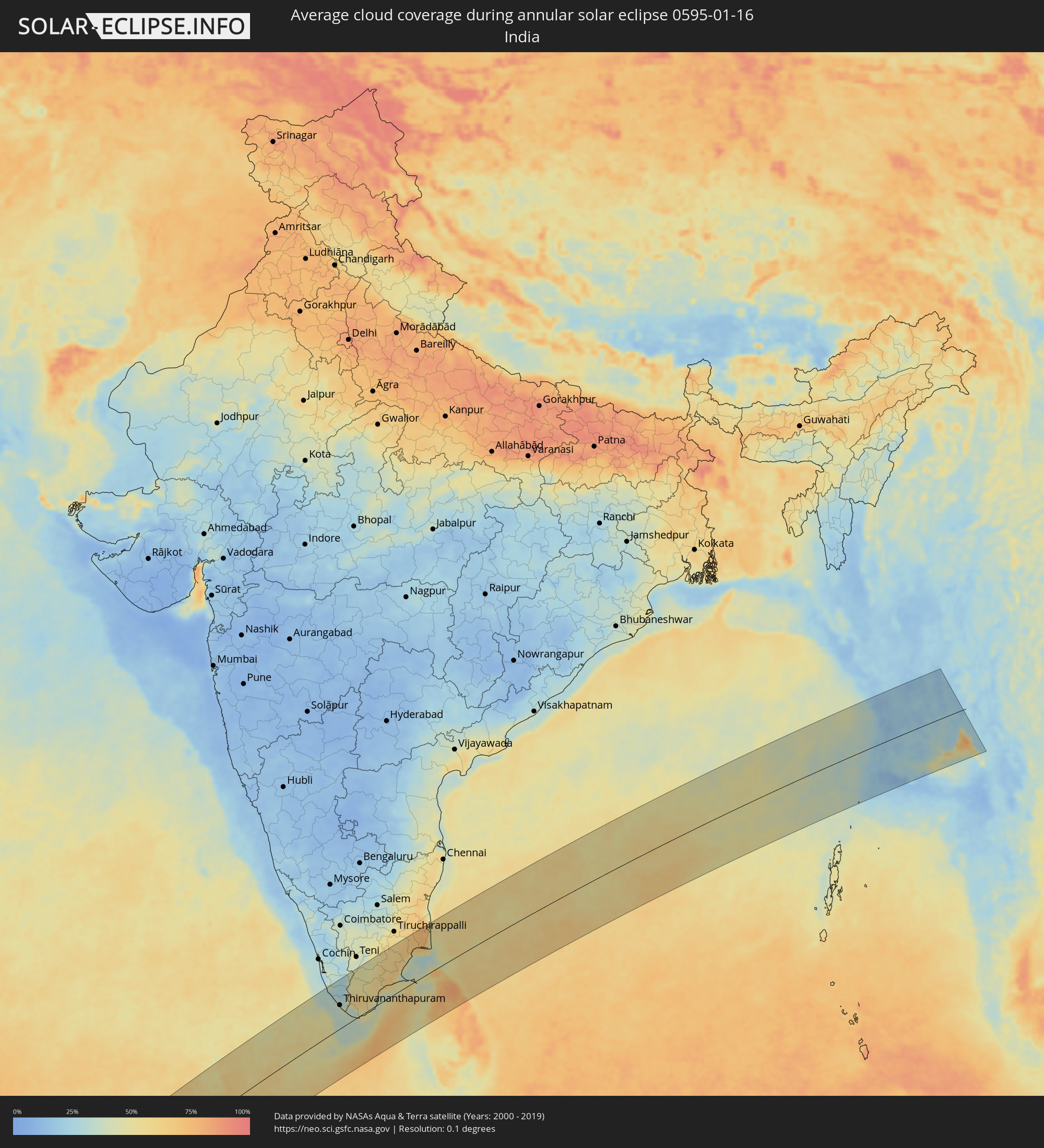 India
India
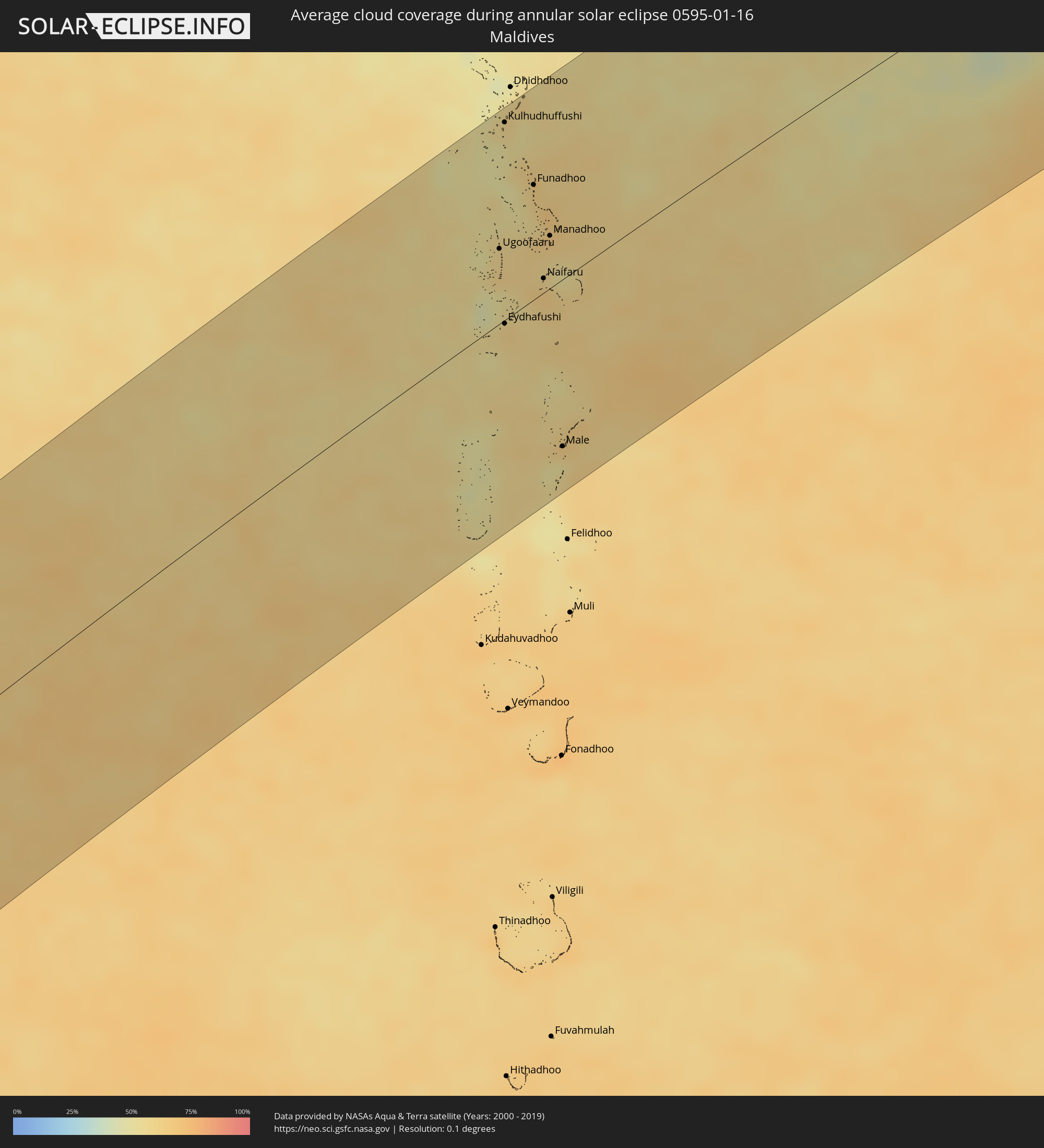 Maldives
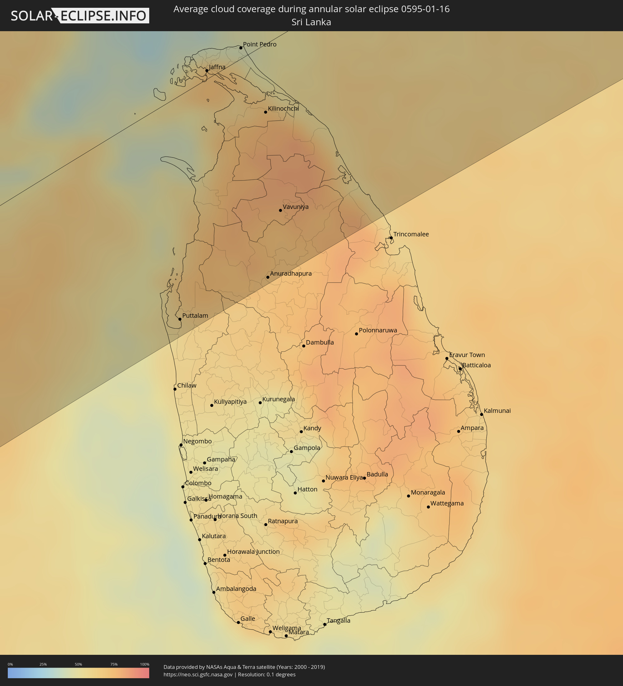 Sri Lanka
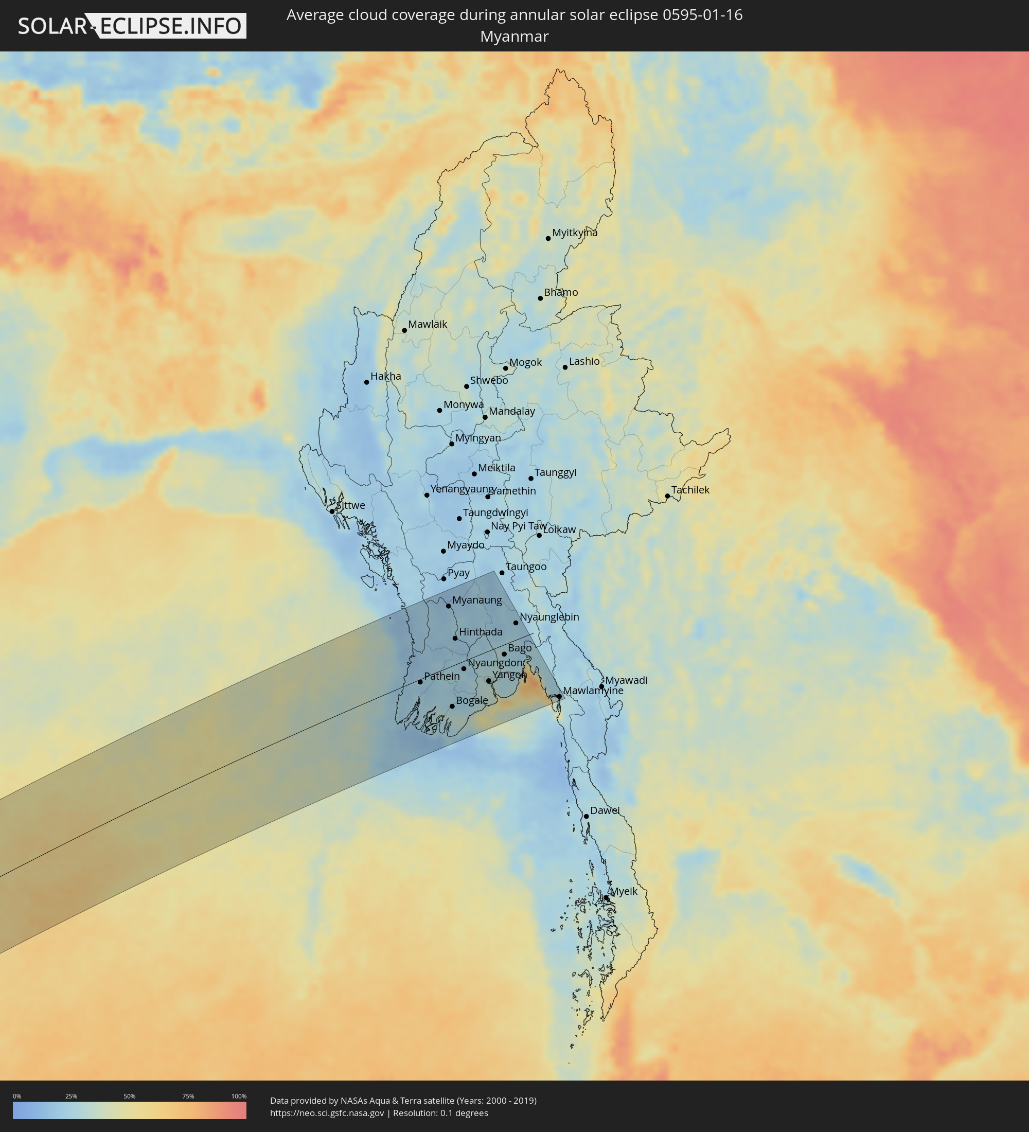 Myanmar
Cities inside the path of the eclipse
The following table shows all locations with a population of more than 5,000 inside the eclipse path. Cities which have more than 100,000 inhabitants are marked bold. A click at the locations opens a detailed map.
| City | Type | Eclipse duration | Local time of max. eclipse | Distance to central line | Ø Cloud coverage |
|
Lüderitz, Karas
|
annular | - | 09:27:44 UTC+01:30 | 116 km | 14% |
|
Bethanie, Karas
|
annular | - | 09:31:36 UTC+01:30 | 85 km | 18% |
|
Mariental, Hardap
|
annular | - | 09:33:12 UTC+01:30 | 124 km | 25% |
|
Keetmanshoop, Karas
|
annular | - | 09:33:39 UTC+01:30 | 93 km | 18% |
|
Tshabong, Kgalagadi
|
annular | - | 10:23:45 UTC+02:10 | 39 km | 29% |
|
Kanye, Ngwaketsi
|
annular | - | 10:31:24 UTC+02:10 | 55 km | 54% |
|
Mosopa, Ngwaketsi
|
annular | - | 10:31:44 UTC+02:10 | 76 km | 57% |
|
Molepolole, Kweneng
|
annular | - | 10:32:06 UTC+02:10 | 115 km | 52% |
|
Thamaga, Kweneng
|
annular | - | 10:32:06 UTC+02:10 | 85 km | 57% |
|
Janeng, South-East
|
annular | - | 10:31:46 UTC+02:10 | 3 km | 53% |
|
Mmabatho, North-West
|
annular | - | 09:51:28 UTC+01:30 | 46 km | 54% |
|
Lobatse, South-East
|
annular | - | 10:32:12 UTC+02:10 | 22 km | 57% |
|
Otse, South-East
|
annular | - | 10:32:27 UTC+02:10 | 45 km | 56% |
|
Gabane, Kweneng
|
annular | - | 10:32:45 UTC+02:10 | 83 km | 53% |
|
Metsemotlhaba, Kweneng
|
annular | - | 10:32:52 UTC+02:10 | 95 km | 52% |
|
Mogoditshane, Kweneng
|
annular | - | 10:32:59 UTC+02:10 | 86 km | 54% |
|
Ramotswa, South-East
|
annular | - | 10:32:53 UTC+02:10 | 59 km | 56% |
|
Kopong, South-East
|
annular | - | 10:33:07 UTC+02:10 | 102 km | 56% |
|
Gaborone, South-East
|
annular | - | 10:33:06 UTC+02:10 | 82 km | 54% |
|
Mochudi, Kgatleng
|
annular | - | 10:33:53 UTC+02:10 | 105 km | 55% |
|
Lichtenburg, North-West
|
annular | - | 09:52:42 UTC+01:30 | 86 km | 53% |
|
Rustenburg, North-West
|
annular | - | 09:55:49 UTC+01:30 | 49 km | 54% |
|
Carletonville, Gauteng
|
annular | - | 09:55:51 UTC+01:30 | 128 km | 53% |
|
Westonaria, Gauteng
|
annular | - | 09:56:32 UTC+01:30 | 128 km | 53% |
|
Krugersdorp, Gauteng
|
annular | - | 09:57:00 UTC+01:30 | 104 km | 57% |
|
Brits, North-West
|
annular | - | 09:57:17 UTC+01:30 | 55 km | 56% |
|
Soweto, Gauteng
|
annular | - | 09:57:07 UTC+01:30 | 126 km | 58% |
|
Ga-Rankuwa, North-West
|
annular | - | 09:57:53 UTC+01:30 | 57 km | 59% |
|
Diepsloot, Gauteng
|
annular | - | 09:57:44 UTC+01:30 | 92 km | 58% |
|
Johannesburg, Gauteng
|
annular | - | 09:57:39 UTC+01:30 | 122 km | 59% |
|
Mabopane, Gauteng
|
annular | - | 09:58:15 UTC+01:30 | 46 km | 58% |
|
Pretoria, Gauteng
|
annular | - | 09:58:20 UTC+01:30 | 74 km | 59% |
|
Tembisa, Gauteng
|
annular | - | 09:58:16 UTC+01:30 | 103 km | 61% |
|
Warmbaths, Limpopo
|
annular | - | 09:59:09 UTC+01:30 | 18 km | 59% |
|
Benoni, Gauteng
|
annular | - | 09:58:24 UTC+01:30 | 125 km | 59% |
|
Delmas, Mpumalanga
|
annular | - | 09:59:25 UTC+01:30 | 128 km | 57% |
|
Mokopane, Limpopo
|
annular | - | 10:01:43 UTC+01:30 | 78 km | 65% |
|
Witbank, Mpumalanga
|
annular | - | 10:01:06 UTC+01:30 | 109 km | 62% |
|
Middelburg, Mpumalanga
|
annular | - | 10:01:48 UTC+01:30 | 103 km | 59% |
|
Polokwane, Limpopo
|
annular | - | 10:03:17 UTC+01:30 | 100 km | 68% |
|
Nelspruit, Mpumalanga
|
annular | - | 10:06:15 UTC+01:30 | 106 km | 75% |
|
Phalaborwa, Limpopo
|
annular | - | 10:08:08 UTC+01:30 | 54 km | 78% |
|
Chokwé, Gaza
|
annular | - | 10:53:16 UTC+02:10 | 62 km | 74% |
|
Macia, Gaza
|
annular | - | 10:53:05 UTC+02:10 | 118 km | 80% |
|
Chibuto, Gaza
|
annular | - | 10:54:42 UTC+02:10 | 95 km | 70% |
|
Manjacaze, Gaza
|
annular | - | 10:55:42 UTC+02:10 | 109 km | 81% |
|
Maxixe, Inhambane
|
annular | - | 11:01:02 UTC+02:10 | 71 km | 77% |
|
Inhambane, Inhambane
|
annular | - | 11:01:08 UTC+02:10 | 73 km | 74% |
|
Maintirano, Melaky
|
annular | - | 11:53:57 UTC+02:27 | 70 km | 75% |
|
Belo sur Tsiribihina, Menabe
|
annular | - | 11:52:05 UTC+02:27 | 111 km | 74% |
|
Mahabe, Melaky
|
annular | - | 11:59:43 UTC+02:27 | 79 km | 85% |
|
Tsiroanomandidy, Bongolava
|
annular | - | 11:58:09 UTC+02:27 | 117 km | 71% |
|
Sitampiky, Boeny
|
annular | - | 12:02:45 UTC+02:27 | 67 km | 78% |
|
Fenoarivo Be, Bongolava
|
annular | - | 12:00:16 UTC+02:27 | 120 km | 75% |
|
Marovoay, Boeny
|
annular | - | 12:05:27 UTC+02:27 | 81 km | 78% |
|
Ambato Boeny, Boeny
|
annular | - | 12:04:53 UTC+02:27 | 45 km | 72% |
|
Maevatanana, Betsiboka
|
annular | - | 12:04:09 UTC+02:27 | 5 km | 79% |
|
Tsaratanana, Betsiboka
|
annular | - | 12:06:40 UTC+02:27 | 45 km | 81% |
|
Antsohihy, Sofia
|
annular | - | 12:11:46 UTC+02:27 | 99 km | 81% |
|
Bemaitso, Alaotra Mangoro
|
annular | - | 12:08:18 UTC+02:27 | 125 km | 82% |
|
Andilamena, Alaotra Mangoro
|
annular | - | 12:08:37 UTC+02:27 | 125 km | 84% |
|
Bealanana, Sofia
|
annular | - | 12:14:29 UTC+02:27 | 76 km | 82% |
|
Antsirabe Afovoany, Sofia
|
annular | - | 12:11:56 UTC+02:27 | 60 km | 87% |
|
Andapa, Sava
|
annular | - | 12:16:32 UTC+02:27 | 5 km | 88% |
|
Maroantsetra, Analanjirofo
|
annular | - | 12:15:01 UTC+02:27 | 68 km | 72% |
|
Antakotako, Analanjirofo
|
annular | - | 12:15:26 UTC+02:27 | 62 km | 81% |
|
Ambodivoara, Sava
|
annular | - | 12:18:04 UTC+02:27 | 9 km | 85% |
|
Sambava, Sava
|
annular | - | 12:18:40 UTC+02:27 | 1 km | 73% |
|
Ampahana, Sava
|
annular | - | 12:17:43 UTC+02:27 | 43 km | 78% |
|
Antalaha, Sava
|
annular | - | 12:17:33 UTC+02:27 | 60 km | 75% |
|
Ugoofaaru, Raa Atoll
|
annular | - | 15:56:43 UTC+04:54 | 52 km | 57% |
|
Kulhudhuffushi, Haa Dhaalu Atholhu
|
annular | - | 15:57:48 UTC+04:54 | 136 km | 57% |
|
Eydhafushi, Baa Atholhu
|
annular | - | 15:56:06 UTC+04:54 | 2 km | 61% |
|
Funadhoo, Shaviyani Atholhu
|
annular | - | 15:57:27 UTC+04:54 | 79 km | 64% |
|
Naifaru, Lhaviyani Atholhu
|
annular | - | 15:56:43 UTC+04:54 | 10 km | 63% |
|
Manadhoo, Noonu Atoll
|
annular | - | 15:57:07 UTC+04:54 | 36 km | 65% |
|
Male, Kaafu Atoll
|
annular | - | 15:55:21 UTC+04:54 | 115 km | 62% |
|
Kollam, Kerala
|
annular | - | 16:29:36 UTC+05:21 | 129 km | 34% |
|
Varkala, Kerala
|
annular | - | 16:29:33 UTC+05:21 | 107 km | 34% |
|
Punalūr, Kerala
|
annular | - | 16:29:56 UTC+05:21 | 121 km | 26% |
|
Thiruvananthapuram, Kerala
|
annular | - | 16:29:27 UTC+05:21 | 70 km | 37% |
|
Neyyāttinkara, Kerala
|
annular | - | 16:29:27 UTC+05:21 | 54 km | 40% |
|
Kadayanallur, Tamil Nadu
|
annular | - | 16:30:13 UTC+05:21 | 102 km | 47% |
|
Nāgercoil, Tamil Nadu
|
annular | - | 16:29:27 UTC+05:21 | 13 km | 35% |
|
Rajapalaiyam, Tamil Nadu
|
annular | - | 16:30:40 UTC+05:21 | 126 km | 46% |
|
Tirunelveli, Tamil Nadu
|
annular | - | 16:30:05 UTC+05:21 | 49 km | 60% |
|
Sivakasi, Tamil Nadu
|
annular | - | 16:30:48 UTC+05:21 | 111 km | 46% |
|
Kovilpatti, Tamil Nadu
|
annular | - | 16:30:36 UTC+05:21 | 81 km | 53% |
|
Virudunagar, Tamil Nadu
|
annular | - | 16:31:00 UTC+05:21 | 114 km | 52% |
|
Aruppukkottai, Tamil Nadu
|
annular | - | 16:31:00 UTC+05:21 | 99 km | 55% |
|
Madurai, Tamil Nadu
|
annular | - | 16:31:22 UTC+05:21 | 137 km | 51% |
|
Paramagudi, Tamil Nadu
|
annular | - | 16:31:18 UTC+05:21 | 74 km | 65% |
|
Kāraikkudi, Tamil Nadu
|
annular | - | 16:31:49 UTC+05:21 | 113 km | 62% |
|
Pudukkottai, Tamil Nadu
|
annular | - | 16:32:06 UTC+05:21 | 140 km | 60% |
|
Ramanathapuram, Tamil Nadu
|
annular | - | 16:31:16 UTC+05:21 | 44 km | 47% |
|
Pattukkottai, Tamil Nadu
|
annular | - | 16:32:23 UTC+05:21 | 116 km | 69% |
|
Mannargudi, Tamil Nadu
|
annular | - | 16:32:38 UTC+05:21 | 132 km | 75% |
|
Thiruvarur, Tamil Nadu
|
annular | - | 16:32:48 UTC+05:21 | 131 km | 77% |
|
Puttalam, North Western
|
annular | - | 16:28:57 UTC+05:19 | 140 km | 56% |
|
Kāraikāl, Pondicherry
|
annular | - | 16:33:00 UTC+05:21 | 134 km | 60% |
|
Nāgappattinam, Tamil Nadu
|
annular | - | 16:32:53 UTC+05:21 | 119 km | 60% |
|
Jaffna, Northern Province
|
annular | - | 16:30:27 UTC+05:19 | 5 km | 71% |
|
Valvedditturai, Northern Province
|
annular | - | 16:30:39 UTC+05:19 | 10 km | 60% |
|
Point Pedro, Northern Province
|
annular | - | 16:30:41 UTC+05:19 | 7 km | 60% |
|
Kilinochchi, Northern Province
|
annular | - | 16:30:24 UTC+05:19 | 43 km | 76% |
|
Anuradhapura, North Central
|
annular | - | 16:29:29 UTC+05:19 | 147 km | 71% |
|
Vavuniya, Northern Province
|
annular | - | 16:29:54 UTC+05:19 | 110 km | 75% |
|
Pathein, Ayeyarwady
|
annular | - | 17:42:37 UTC+06:24 | 7 km | 21% |
|
Wakema, Ayeyarwady
|
annular | - | 17:42:32 UTC+06:24 | 44 km | 25% |
|
Myanaung, Ayeyarwady
|
annular | - | 17:43:04 UTC+06:24 | 124 km | 20% |
|
Bogale, Ayeyarwady
|
annular | - | 17:42:25 UTC+06:24 | 84 km | 27% |
|
Hinthada, Ayeyarwady
|
annular | - | 17:42:52 UTC+06:24 | 53 km | 18% |
|
Nyaungdon, Ayeyarwady
|
annular | - | 17:42:39 UTC+06:24 | 17 km | 27% |
|
Maubin, Ayeyarwady
|
annular | - | 17:42:33 UTC+06:24 | 50 km | 24% |
|
Pyapon, Ayeyarwady
|
annular | - | 17:42:24 UTC+06:24 | 97 km | 27% |
|
Kyaiklat, Ayeyarwady
|
annular | - | 17:42:27 UTC+06:24 | 82 km | 24% |
|
Tharyarwady, Bago
|
annular | - | 17:42:50 UTC+06:24 | 40 km | 23% |
|
Twante, Yangon
|
annular | - | 17:42:31 UTC+06:24 | 63 km | 28% |
|
Kanbe, Yangon
|
annular | - | 17:42:31 UTC+06:24 | 66 km | 33% |
|
Yangon, Yangon
|
annular | - | 17:42:32 UTC+06:24 | 63 km | 34% |
|
Syriam, Yangon
|
annular | - | 17:42:31 UTC+06:24 | 70 km | 34% |
|
Pyu, Bago
|
annular | - | 17:43:01 UTC+06:24 | 99 km | 22% |
|
Bago, Bago
|
annular | - | 17:42:41 UTC+06:24 | 21 km | 25% |
|
Thongwa, Yangon
|
annular | - | 17:42:29 UTC+06:24 | 82 km | 28% |
|
Kayan, Yangon
|
annular | - | 17:42:32 UTC+06:24 | 68 km | 27% |
|
Nyaunglebin, Bago
|
annular | - | 17:42:51 UTC+06:24 | 38 km | 23% |
|
Kyaikto, Mon
|
annular | - | 17:42:37 UTC+06:24 | 48 km | 33% |
|
Thaton, Mon
|
annular | - | 17:42:27 UTC+06:24 | 99 km | 26% |
|
Martaban, Mon
|
annular | - | 17:42:18 UTC+06:24 | 149 km | 29% |
|
Mawlamyine, Mon
|
annular | - | 17:42:17 UTC+06:24 | 154 km | 29% |