Total solar eclipse of 08/25/0667
| Day of week: | Sunday |
| Maximum duration of eclipse: | 01m40s |
| Maximum width of eclipse path: | 62 km |
| Saros cycle: | 94 |
| Coverage: | 100% |
| Magnitude: | 1.018 |
| Gamma: | 0.0594 |
Wo kann man die Sonnenfinsternis vom 08/25/0667 sehen?
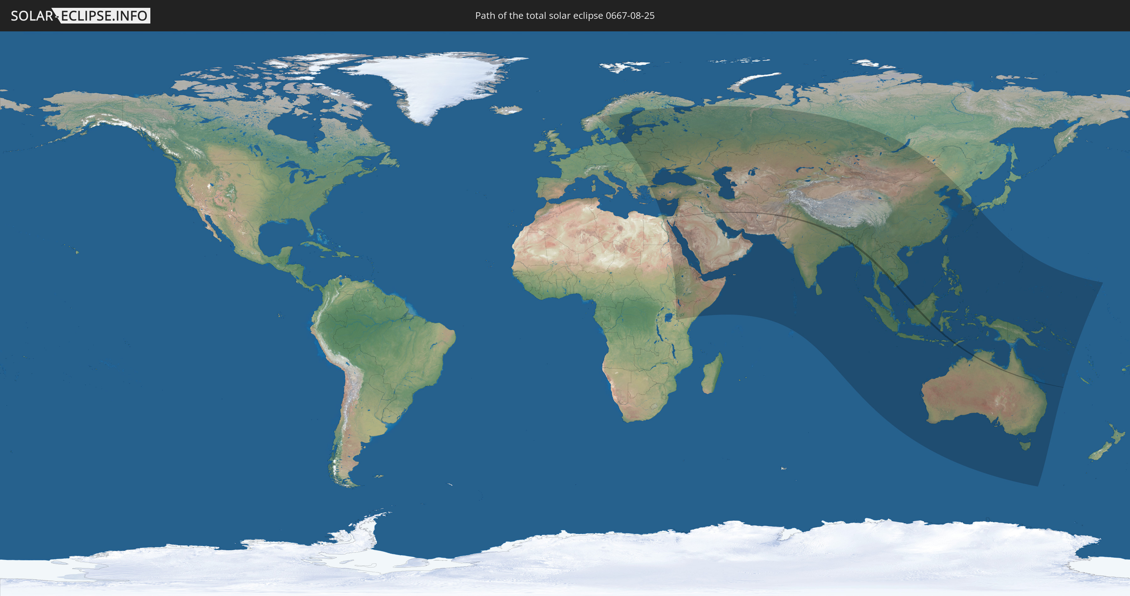
Die Sonnenfinsternis am 08/25/0667 kann man in 85 Ländern als partielle Sonnenfinsternis beobachten.
Der Finsternispfad verläuft durch 18 Länder. Nur in diesen Ländern ist sie als total Sonnenfinsternis zu sehen.
In den folgenden Ländern ist die Sonnenfinsternis total zu sehen
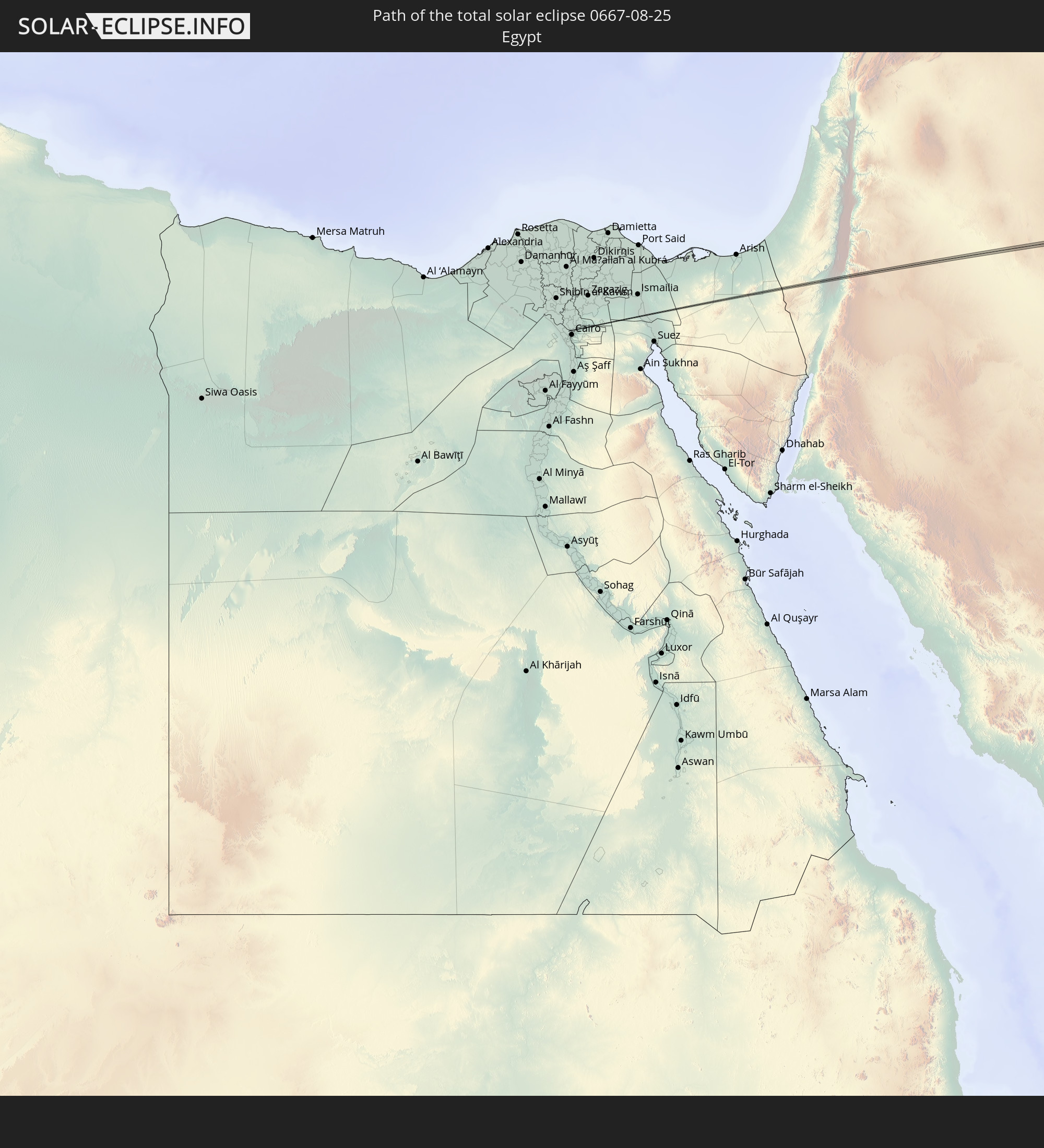 Egypt
Egypt
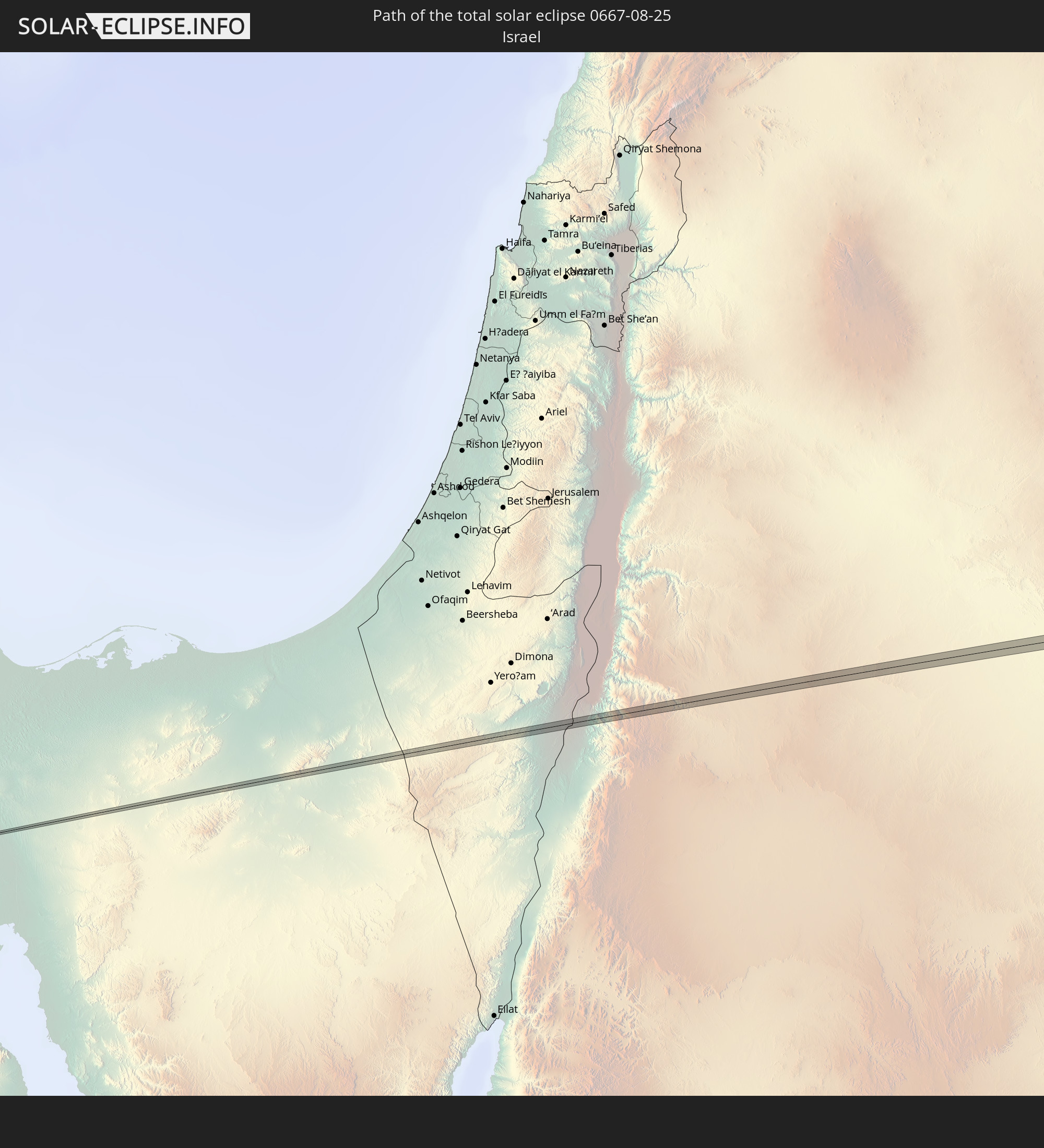 Israel
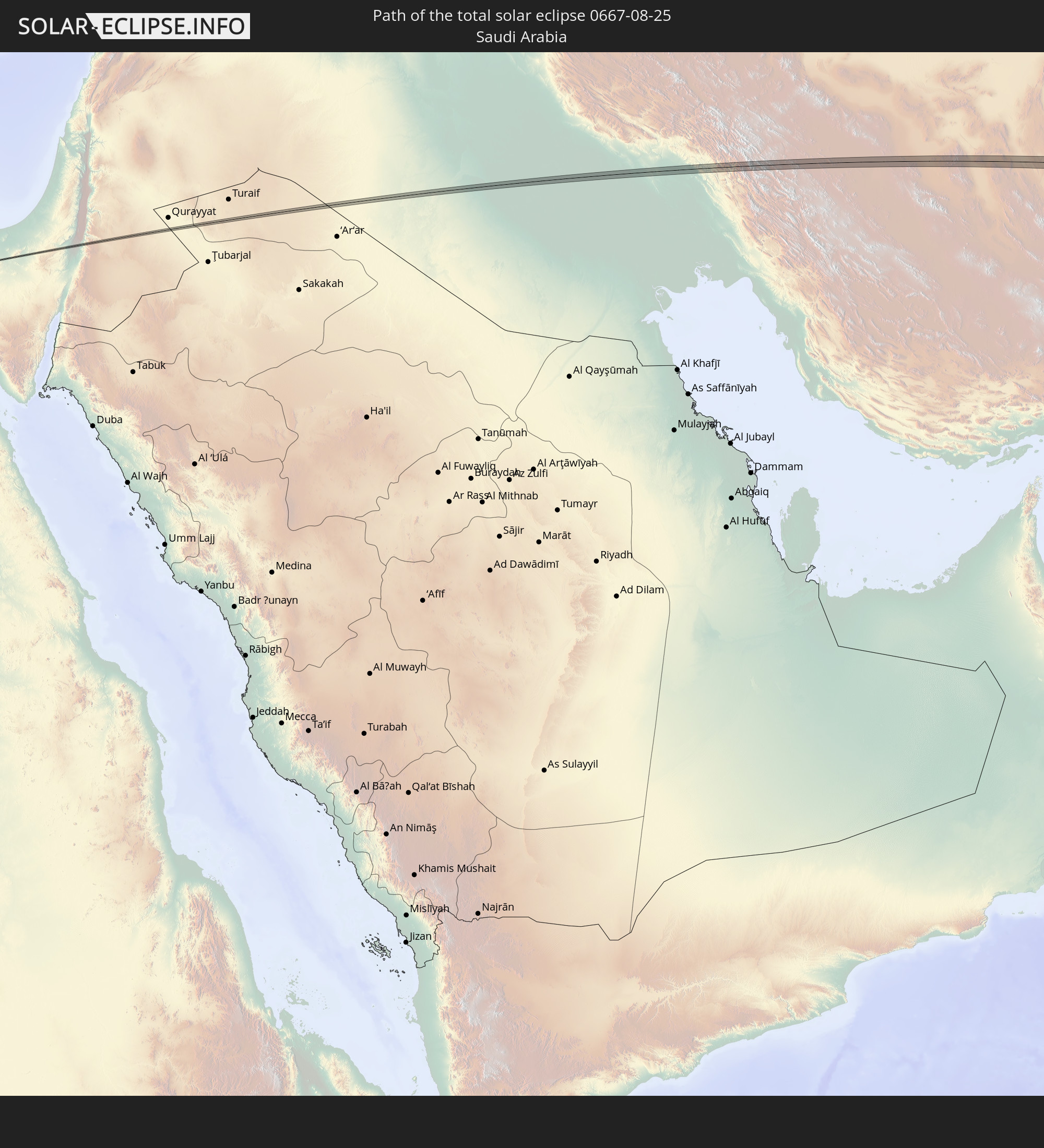 Saudi Arabia
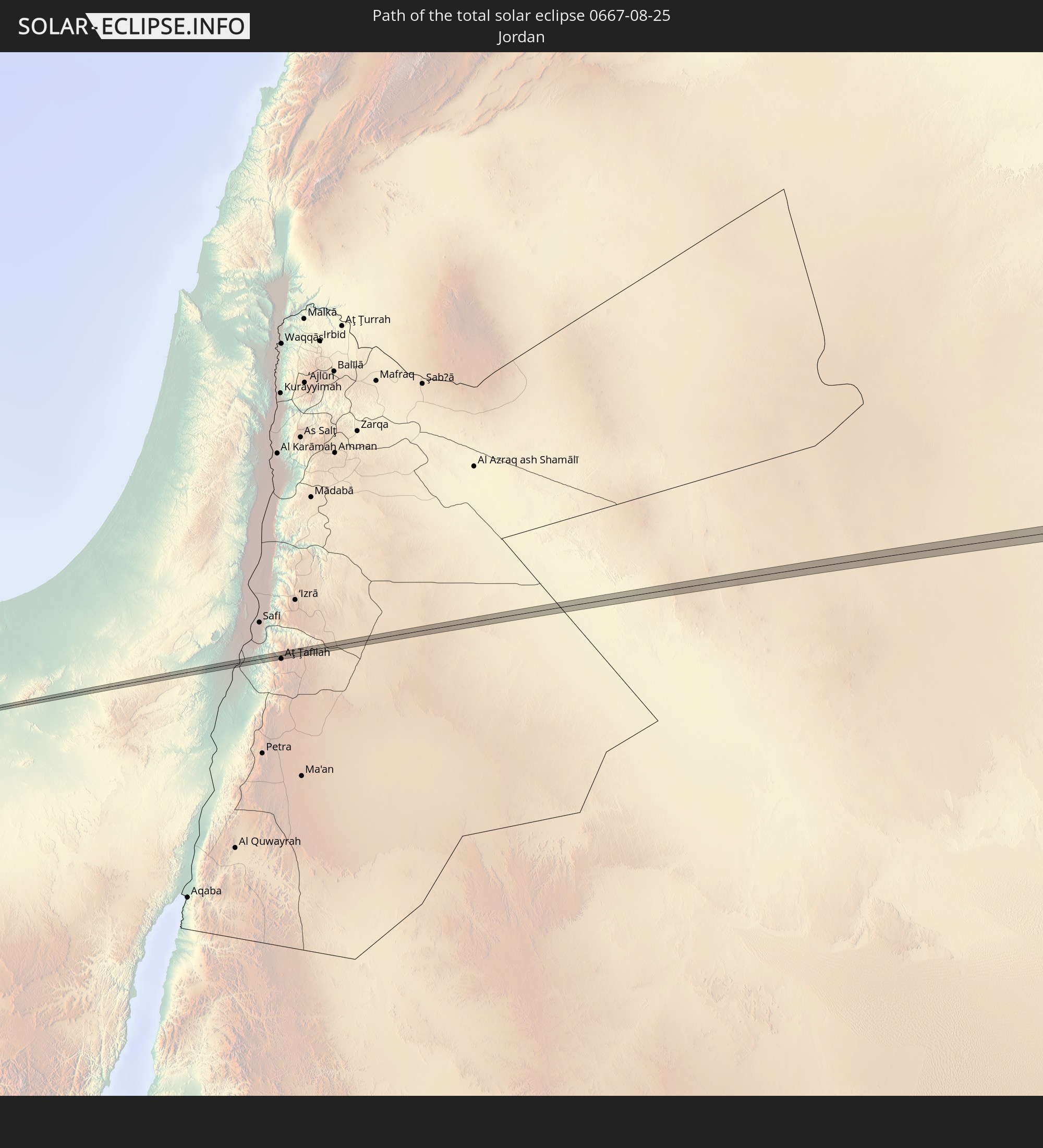 Jordan
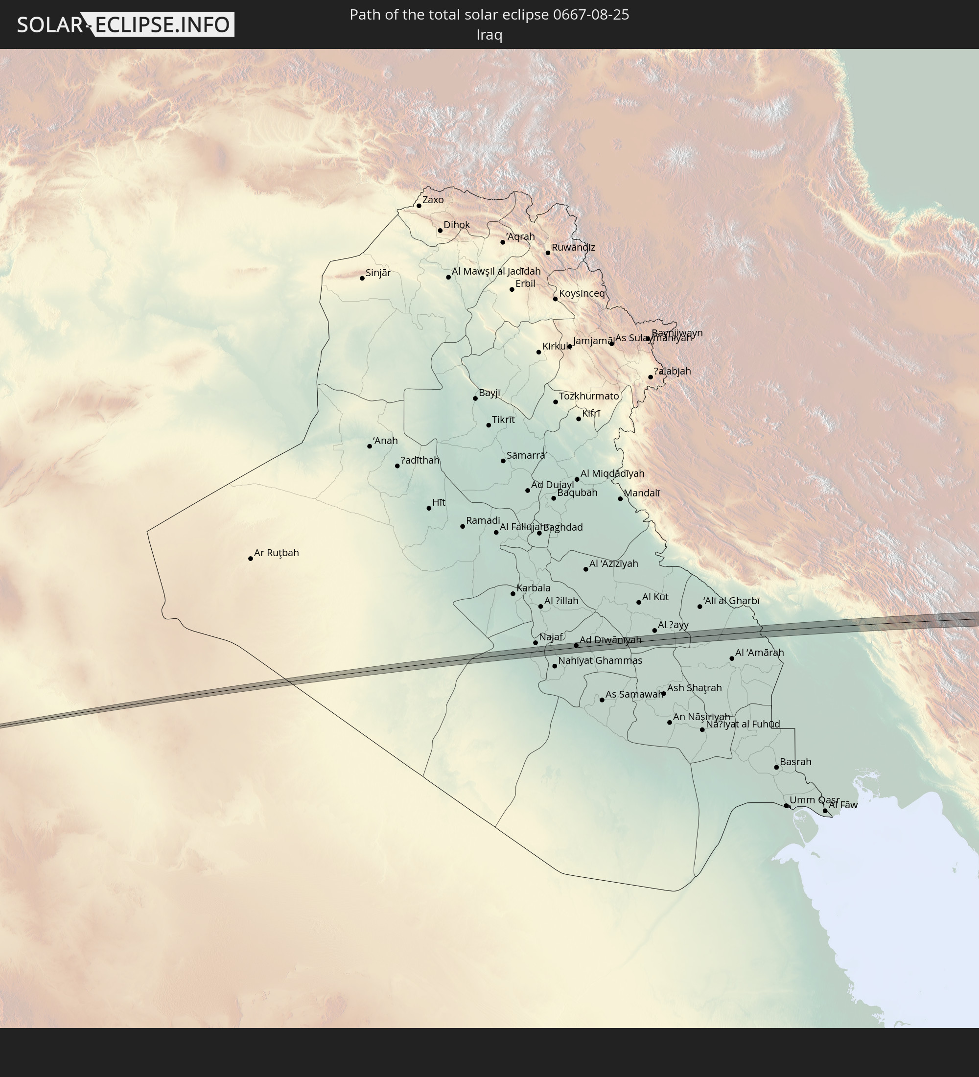 Iraq
Iraq
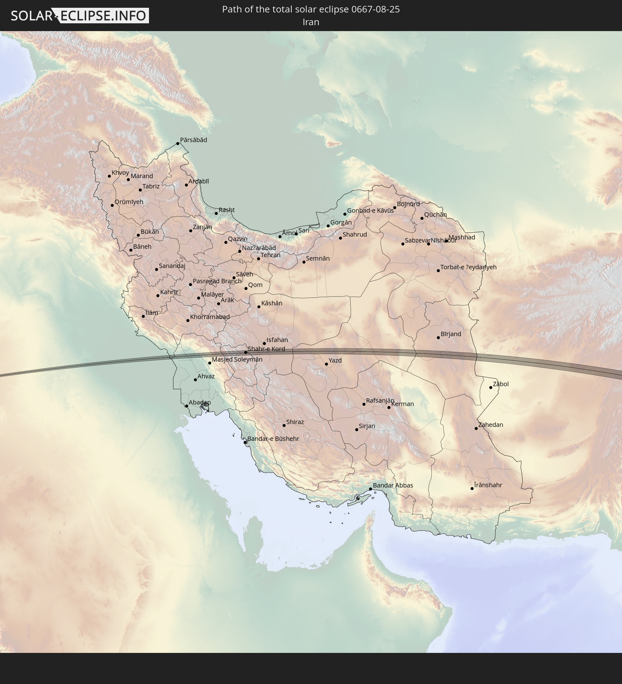 Iran
Iran
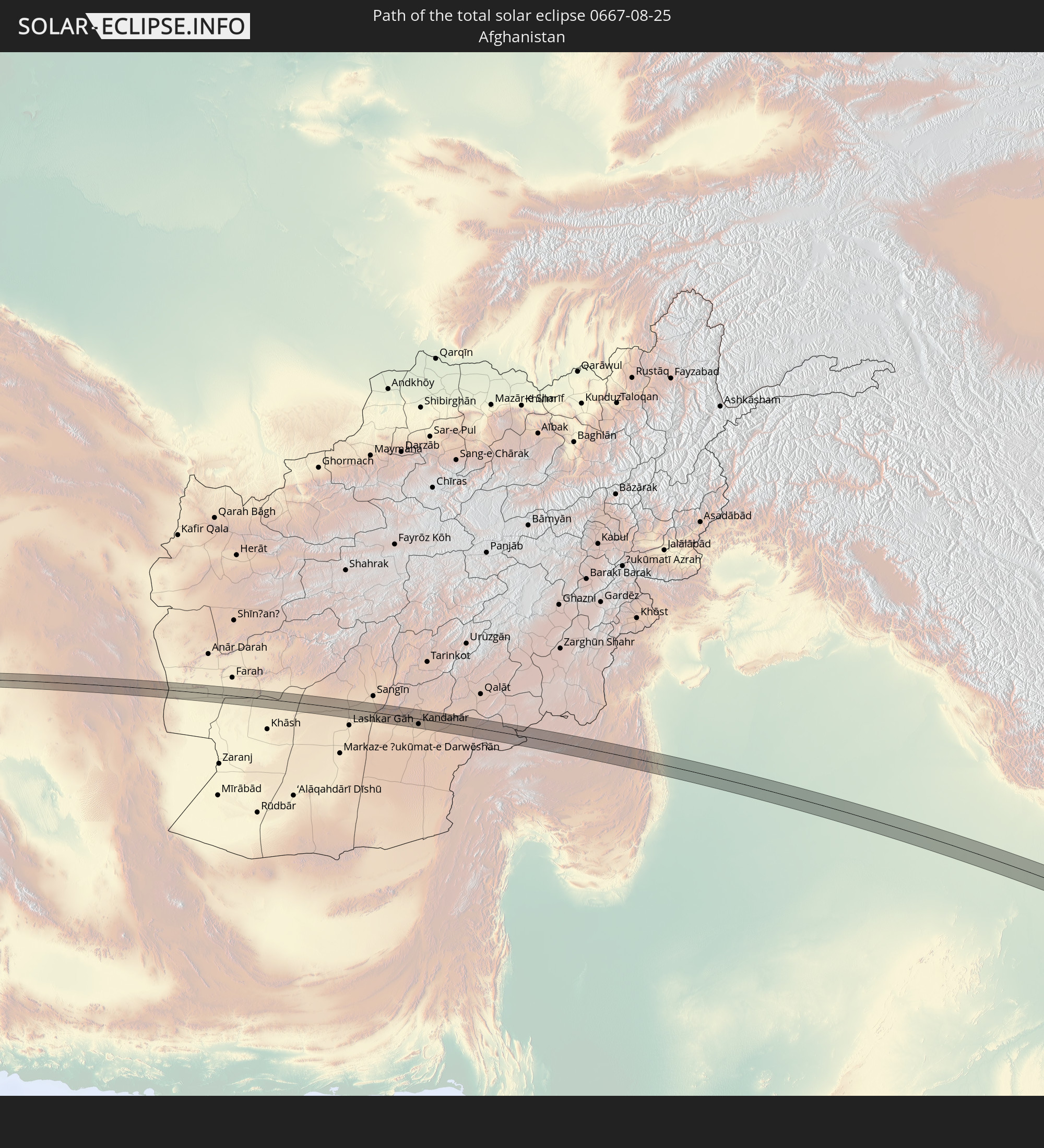 Afghanistan
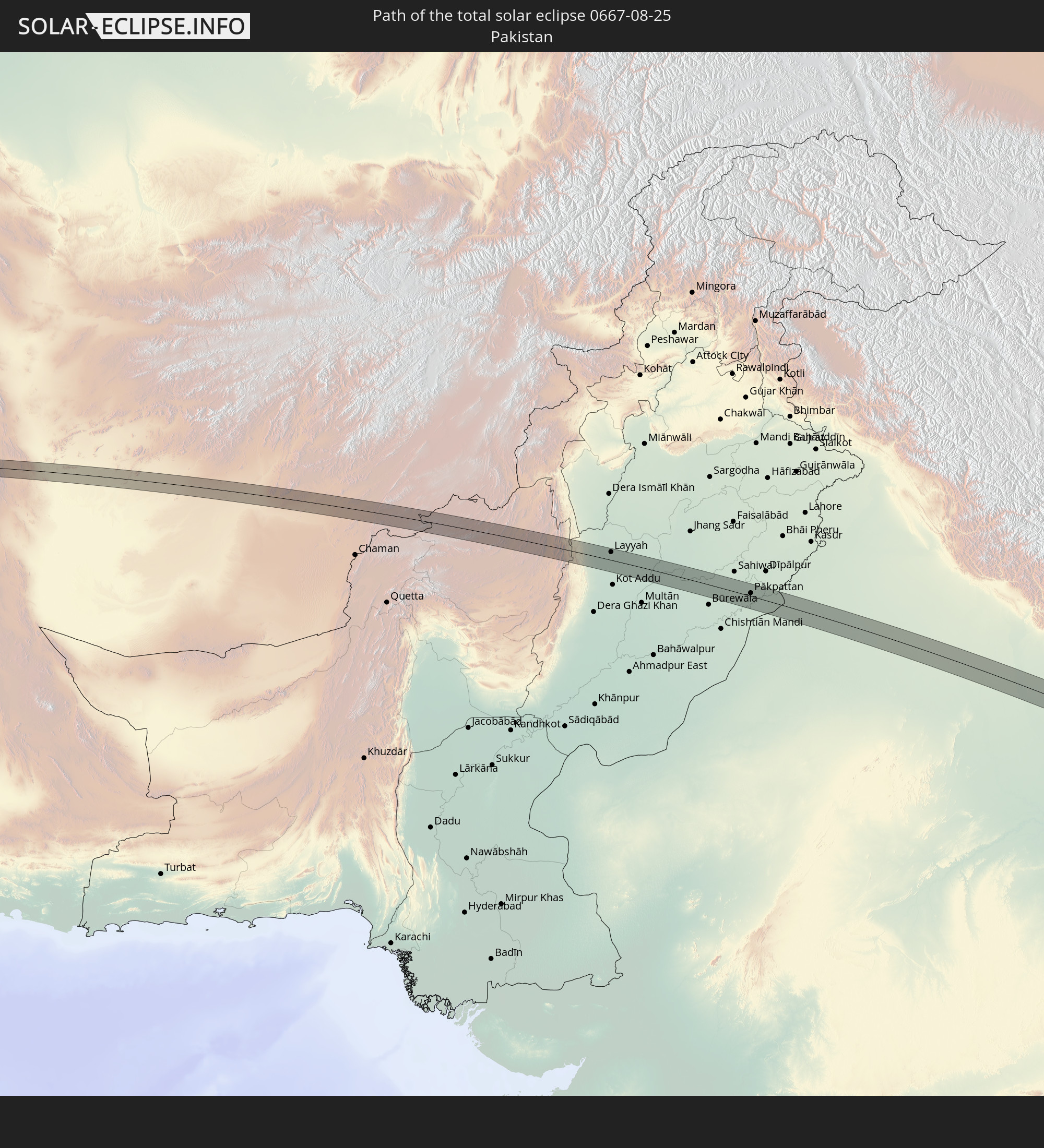 Pakistan
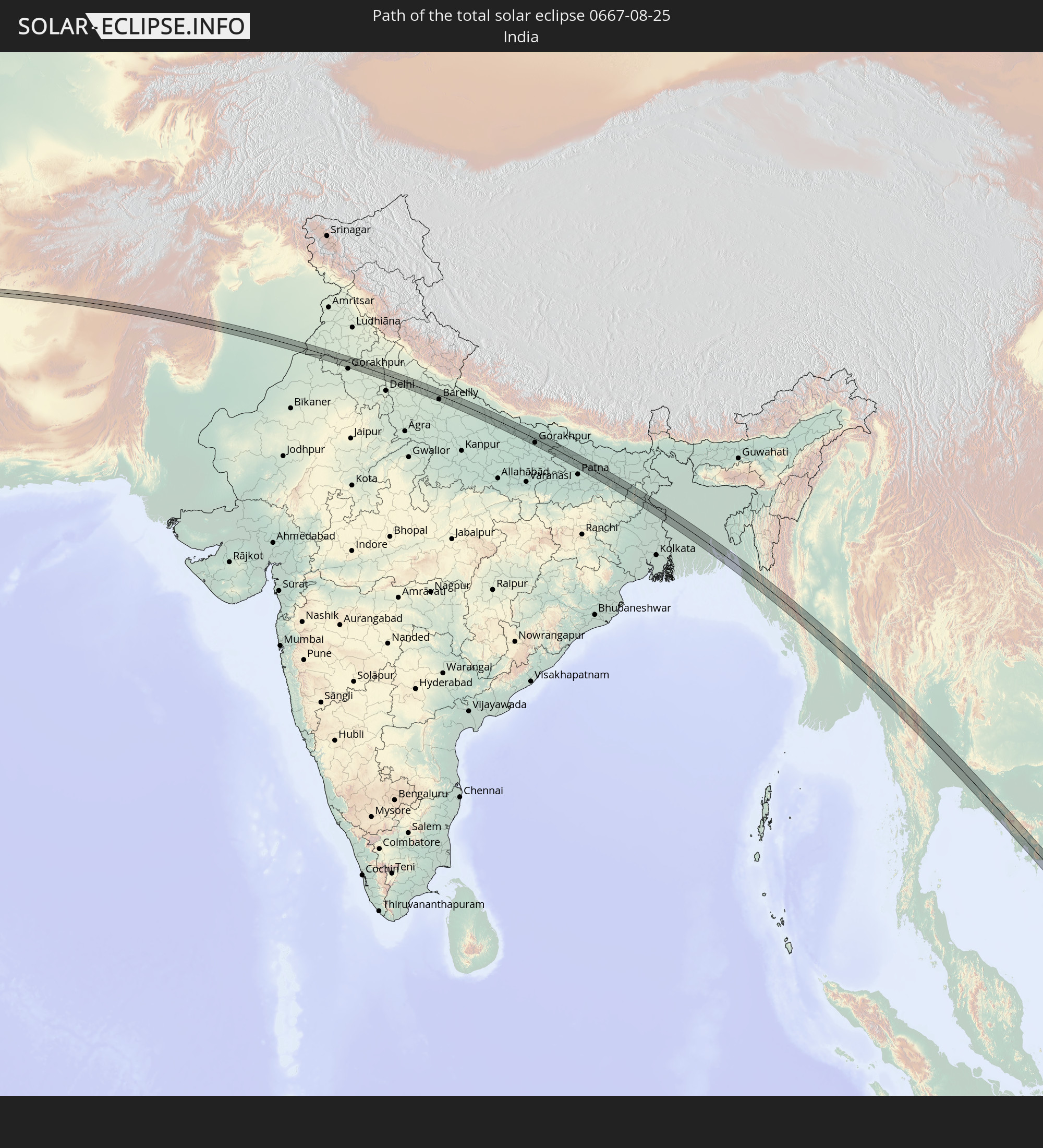 India
India
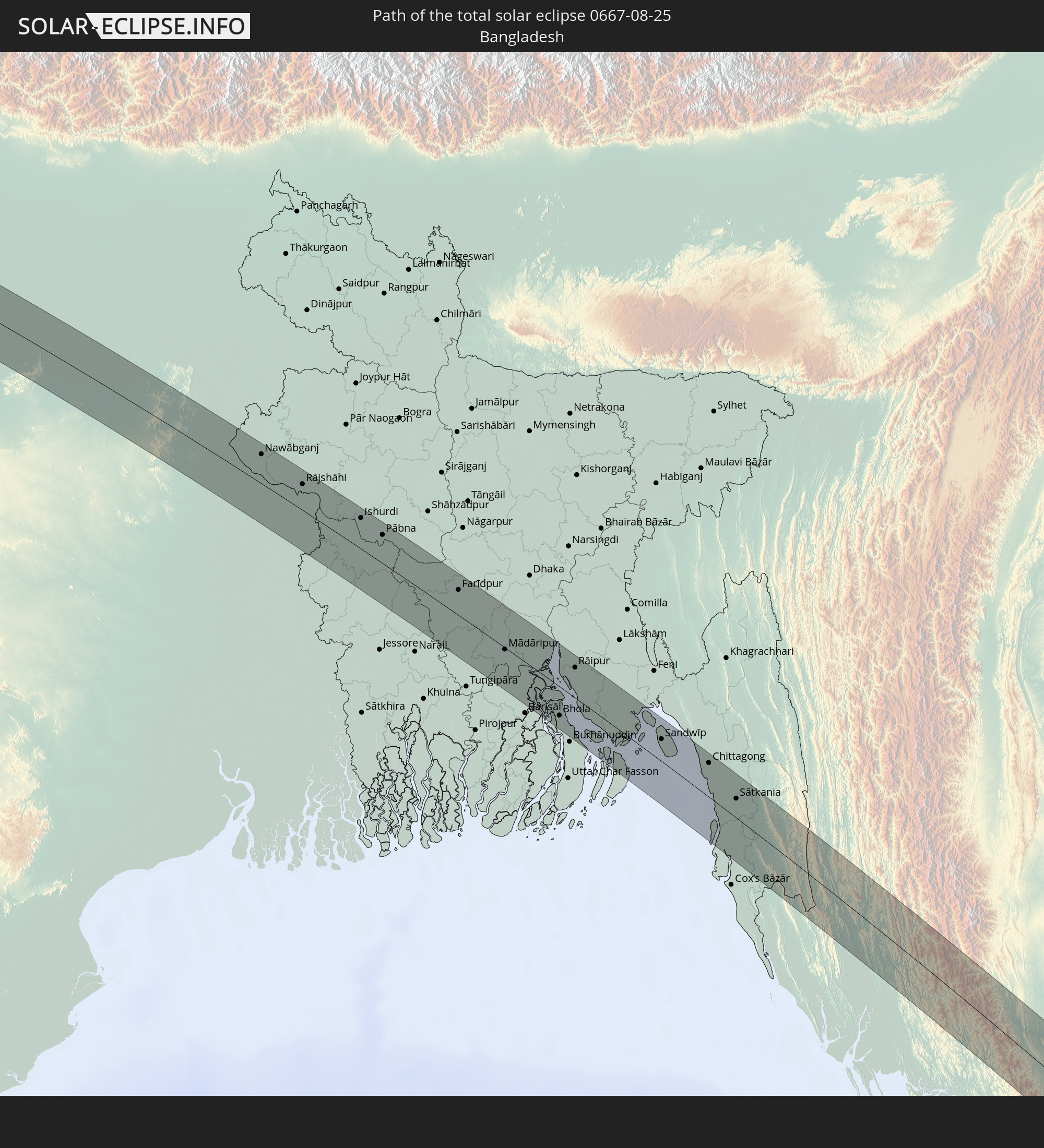 Bangladesh
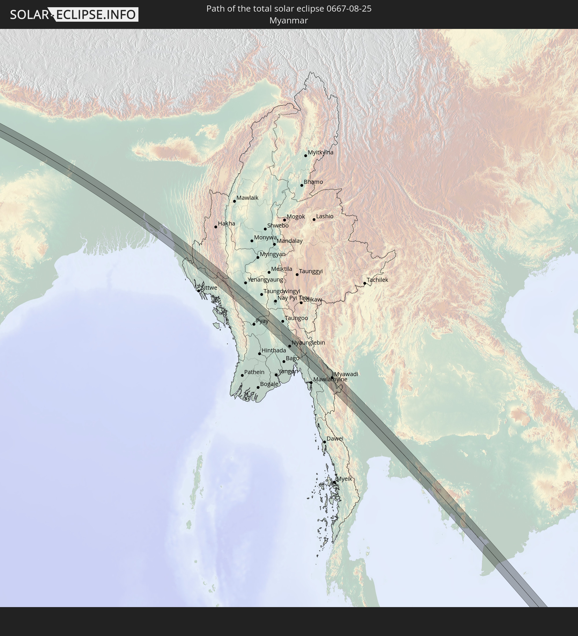 Myanmar
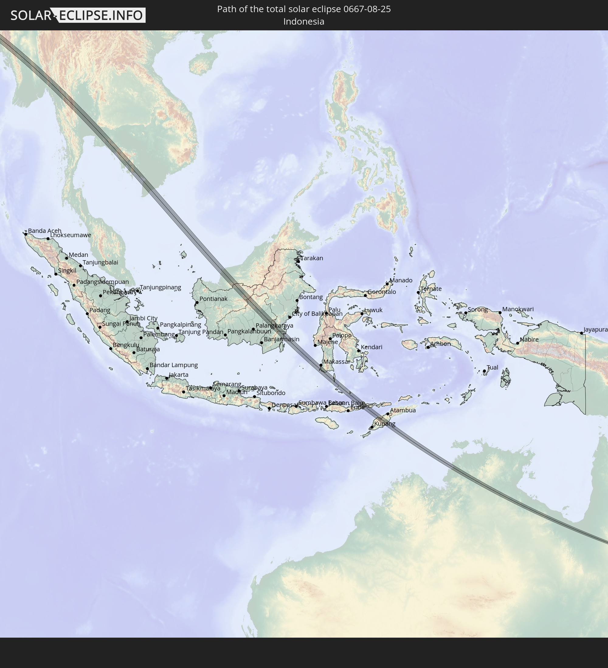 Indonesia
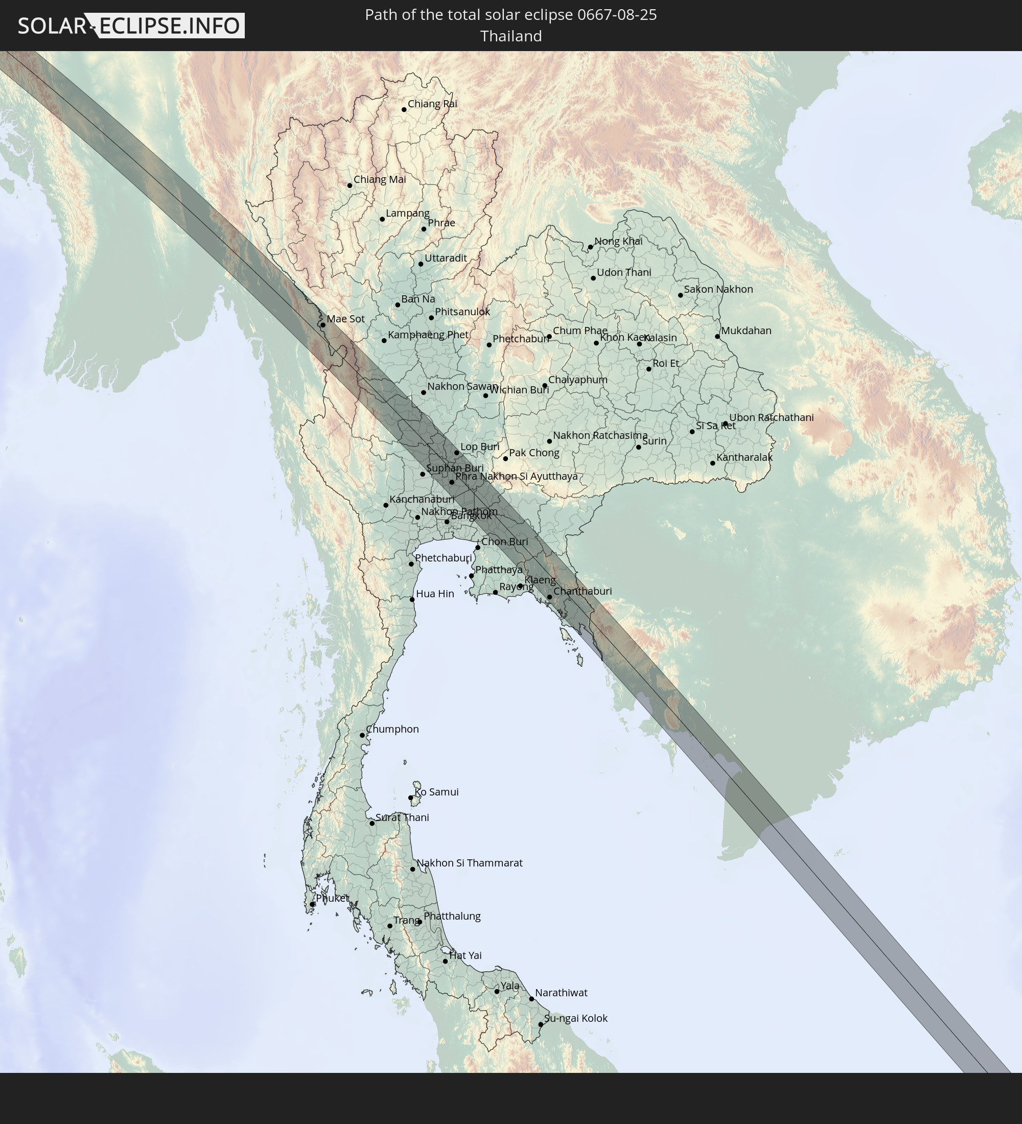 Thailand
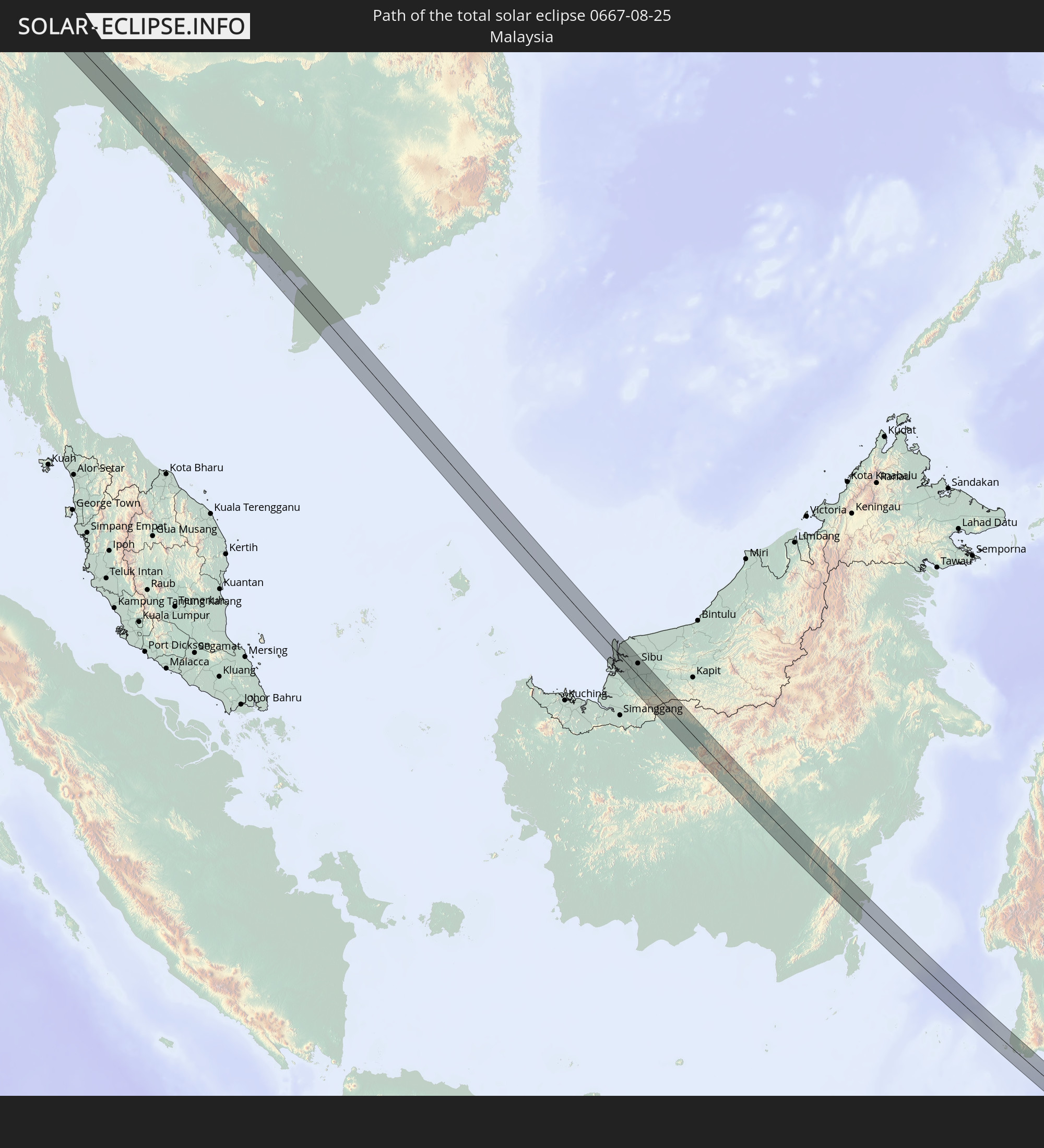 Malaysia
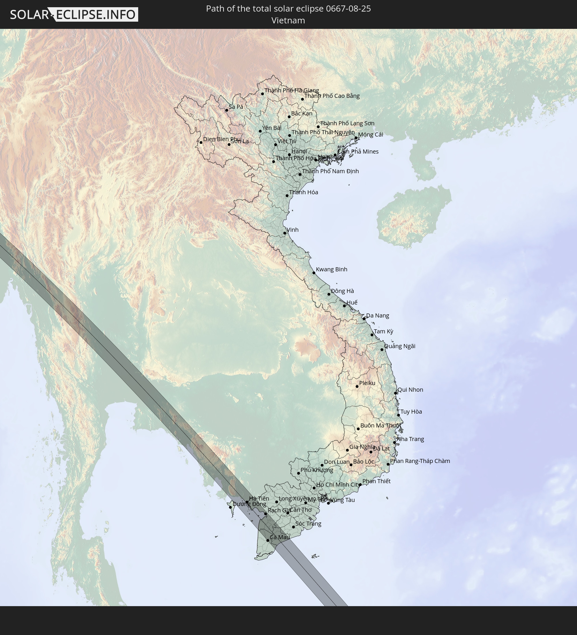 Vietnam
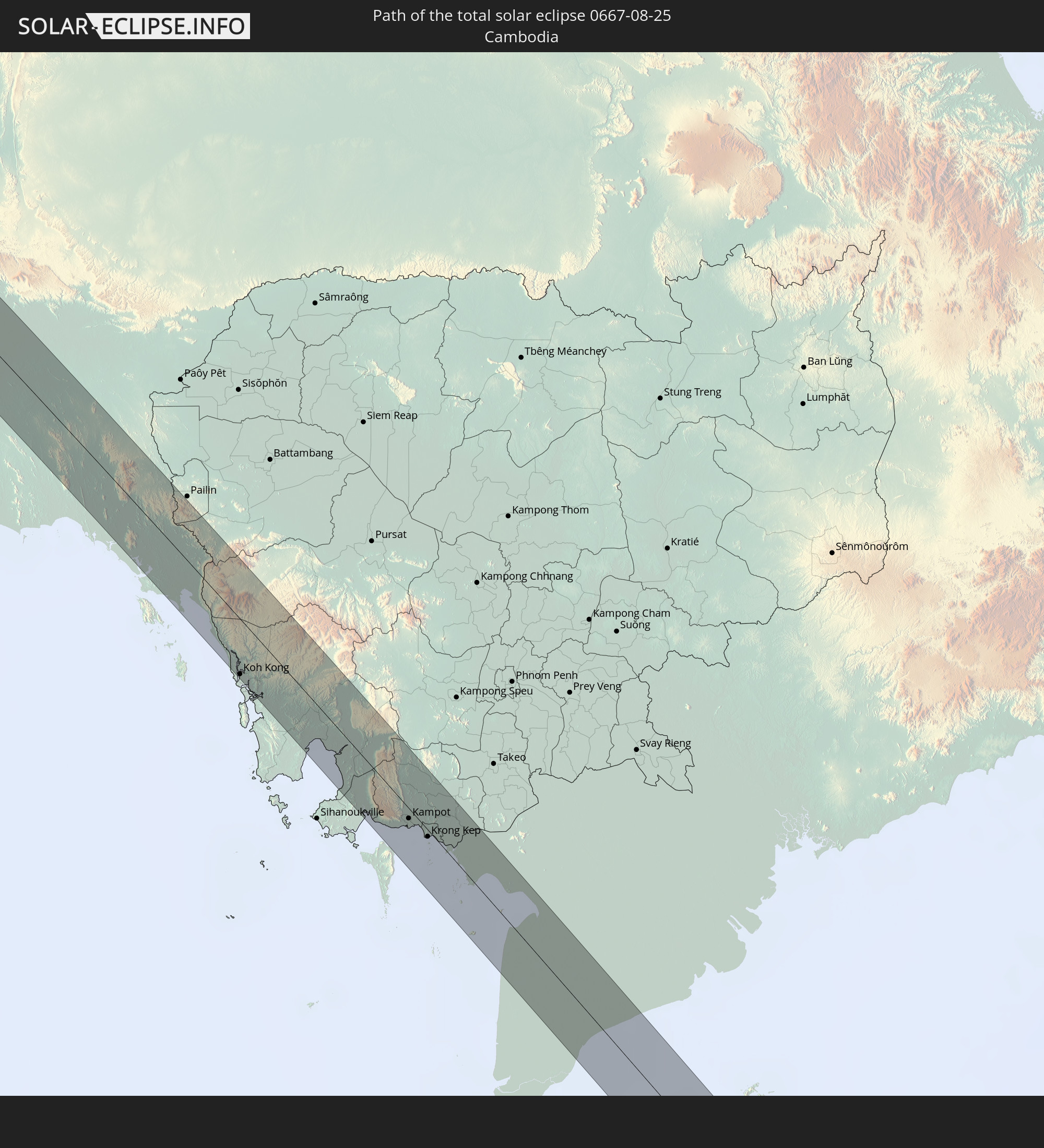 Cambodia
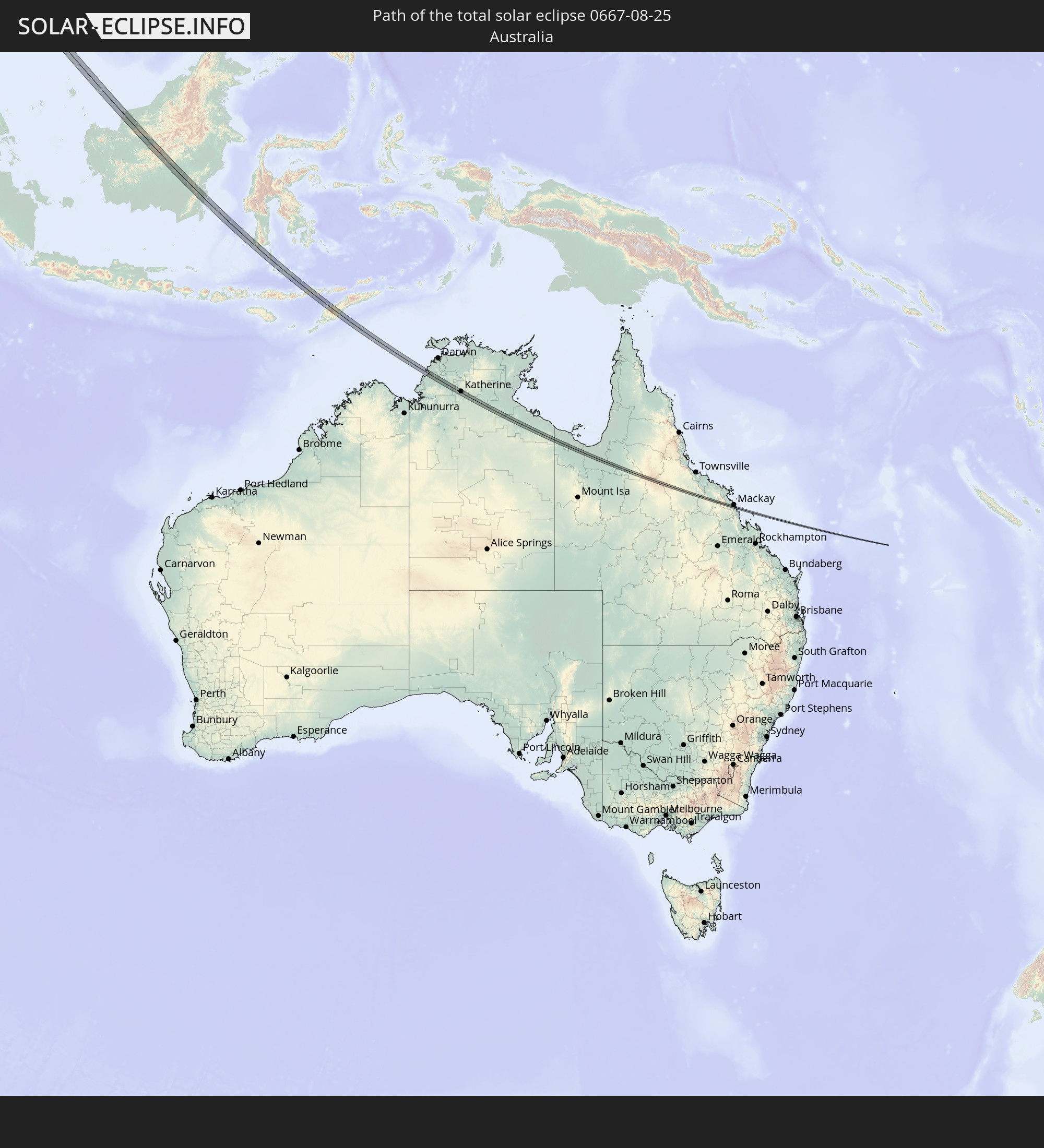 Australia
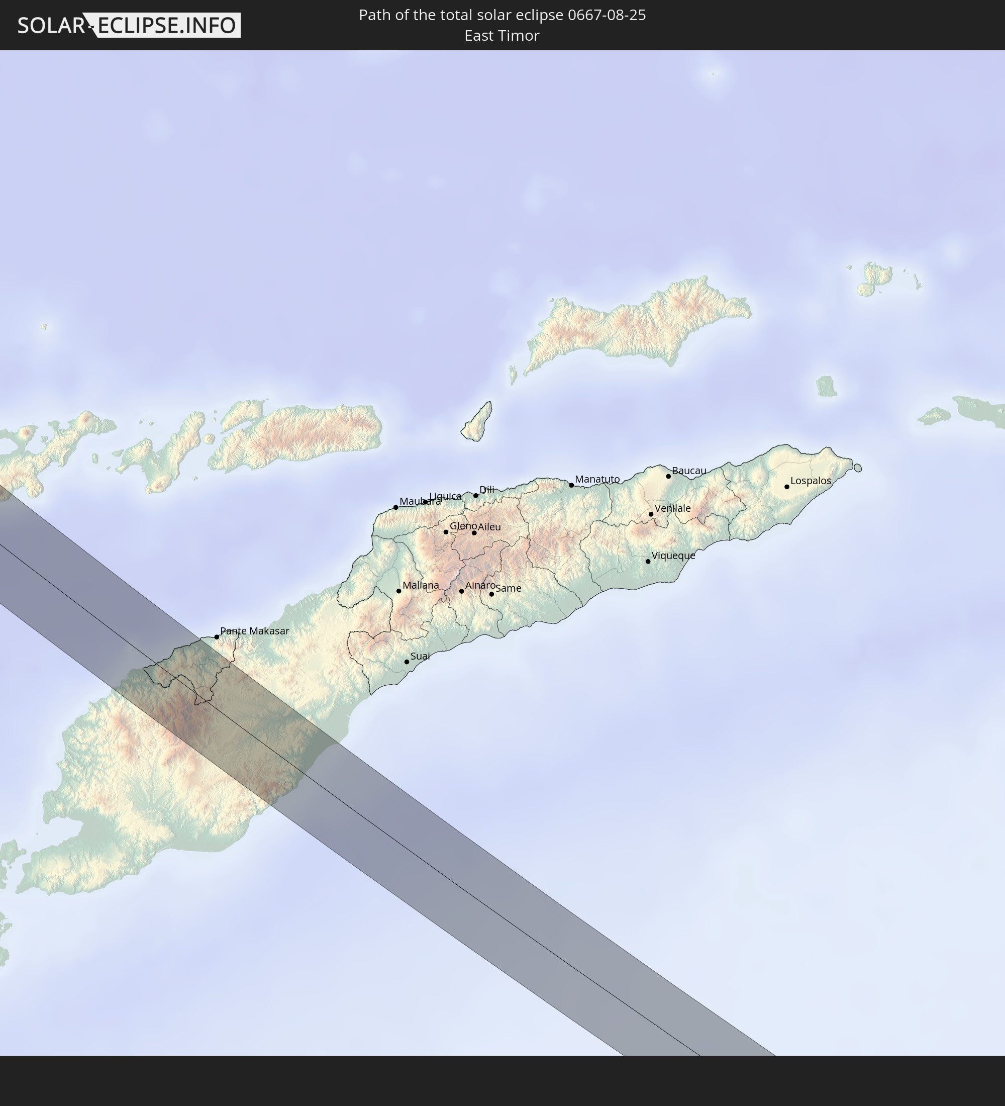 East Timor
In den folgenden Ländern ist die Sonnenfinsternis partiell zu sehen
 Russia
 Norway
 Sweden
 Poland
 Slovakia
 Åland Islands
 Romania
 Finland
 Lithuania
 Latvia
 Estonia
 Sudan
Sudan
 Ukraine
 Bulgaria
 Belarus
 Egypt
Egypt
 Turkey
 Moldova
 Tanzania
 Cyprus
 Ethiopia
 Kenya
Kenya
 State of Palestine
 Israel
 Saudi Arabia
 Jordan
 Lebanon
 Syria
Syria
 Eritrea
 Iraq
Iraq
 Georgia
 Somalia
 Djibouti
 Yemen
Yemen
 Armenia
 Iran
Iran
 Azerbaijan
 Kazakhstan
 Kuwait
 Bahrain
 Qatar
Qatar
 United Arab Emirates
 Oman
Oman
 Turkmenistan
 Uzbekistan
 Afghanistan
 Pakistan
 Tajikistan
 India
India
 Kyrgyzstan
 Maldives
 China
China
 Sri Lanka
 Nepal
Nepal
 Mongolia
 Bangladesh
 Bhutan
 Myanmar
 Indonesia
 Cocos Islands
 Thailand
 Malaysia
 Laos
Laos
 Vietnam
 Cambodia
 Singapore
 Christmas Island
 Australia
 Macau
Macau
 Hong Kong
 Brunei
 Taiwan
 Philippines
 Japan
Japan
 East Timor
 North Korea
 South Korea
 Palau
Palau
 Federated States of Micronesia
 Papua New Guinea
 Guam
Guam
 Northern Mariana Islands
 Solomon Islands
 New Caledonia
 Marshall Islands
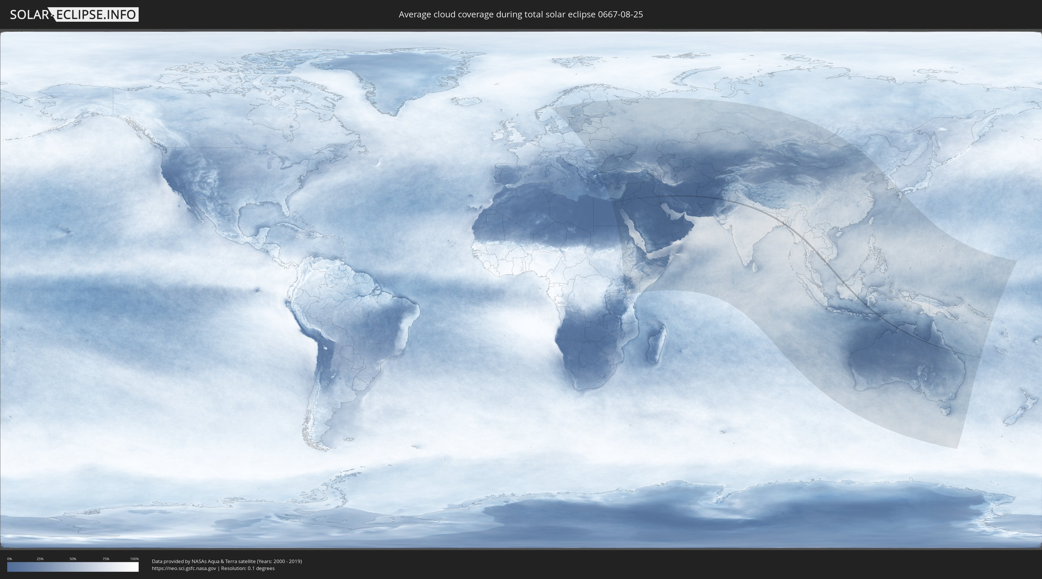
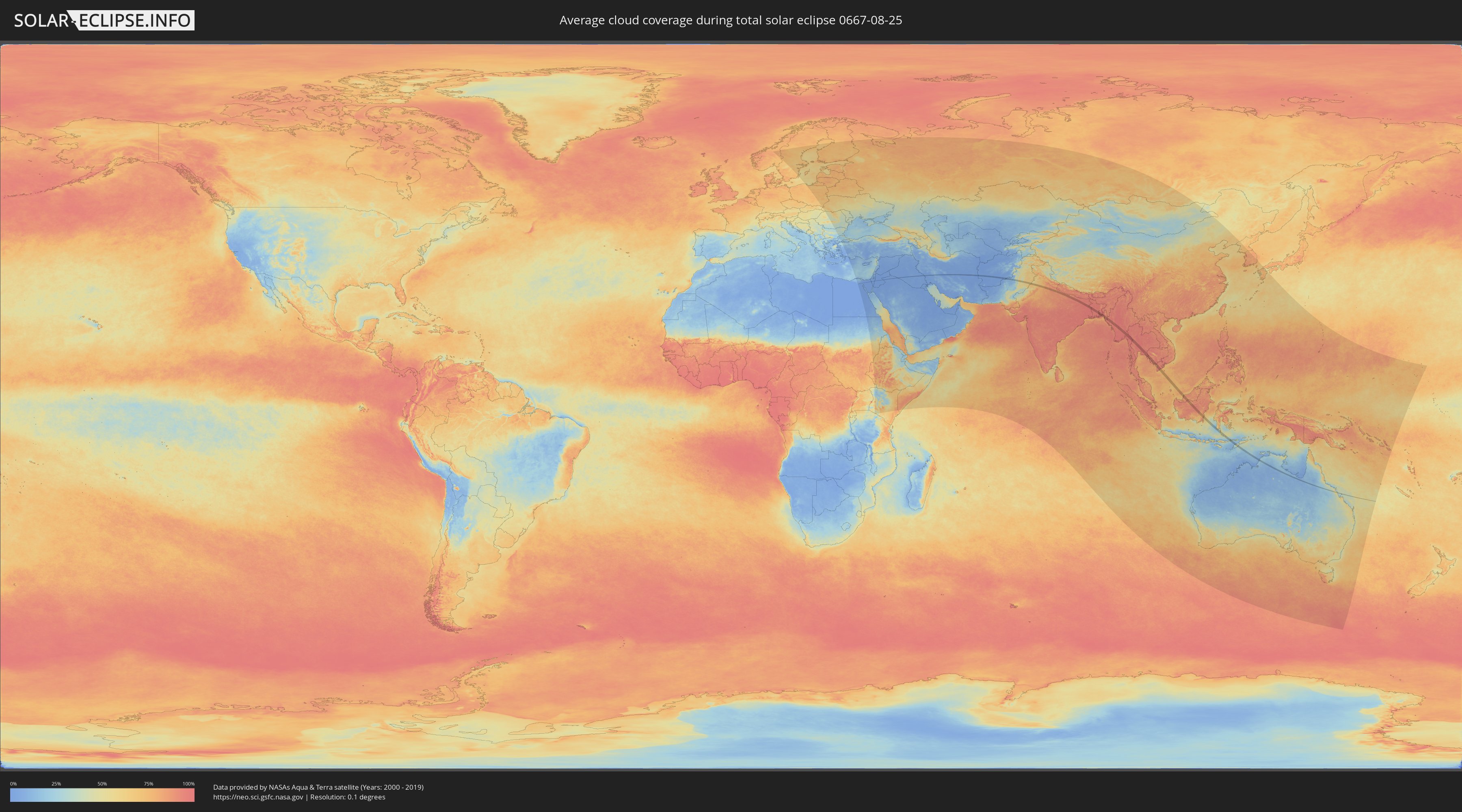
How will be the weather during the total solar eclipse on 08/25/0667?
Where is the best place to see the total solar eclipse of 08/25/0667?
The following maps show the average cloud coverage for the day of the total solar eclipse.
With the help of these maps, it is possible to find the place along the eclipse path, which has the best
chance of a cloudless sky.
Nevertheless, you should consider local circumstances and inform about the weather of your chosen
observation site.
The data is provided by NASAs satellites
AQUA and TERRA.
The cloud maps are averaged over a period of 19 years (2000 - 2019).
Detailed country maps
 Egypt
Egypt
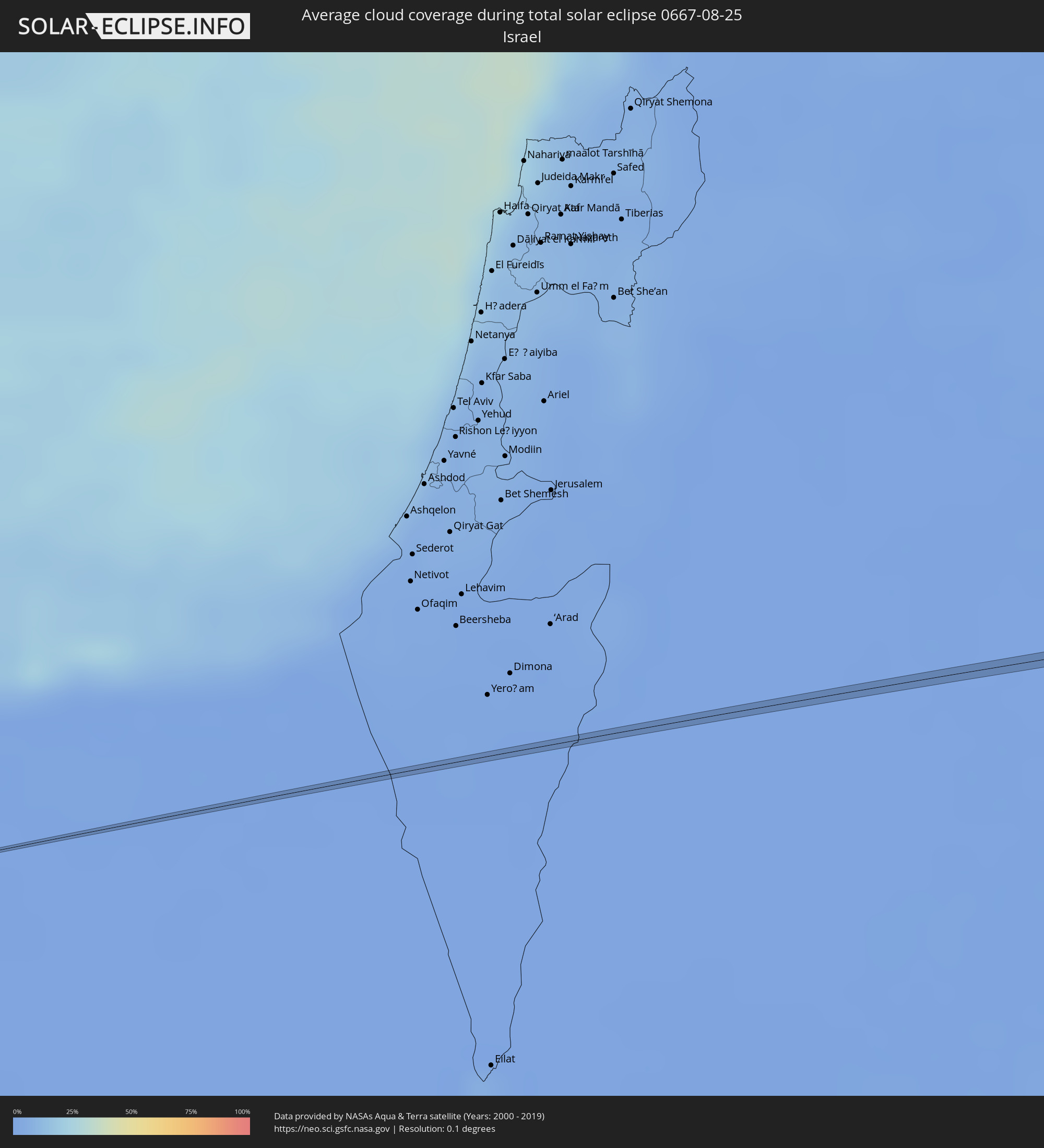 Israel
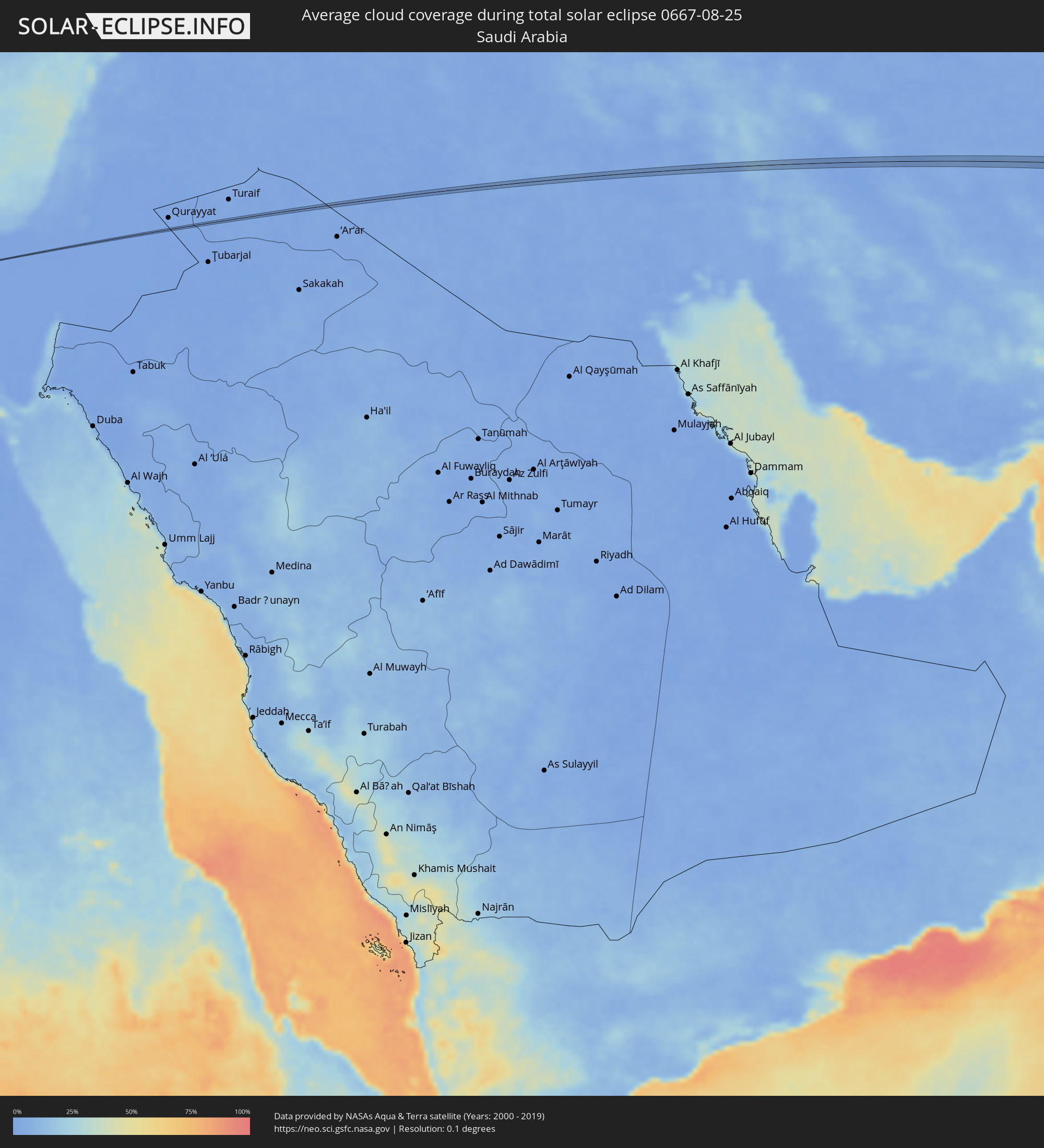 Saudi Arabia
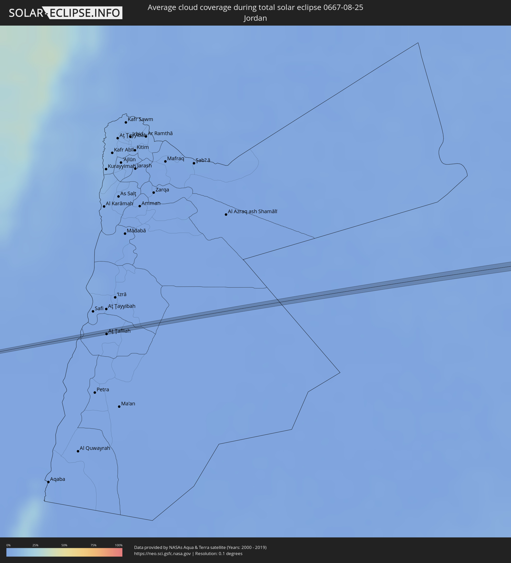 Jordan
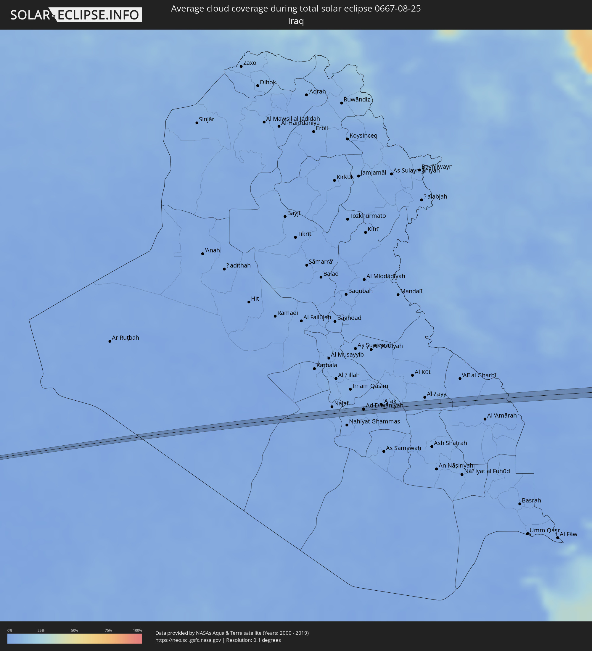 Iraq
Iraq
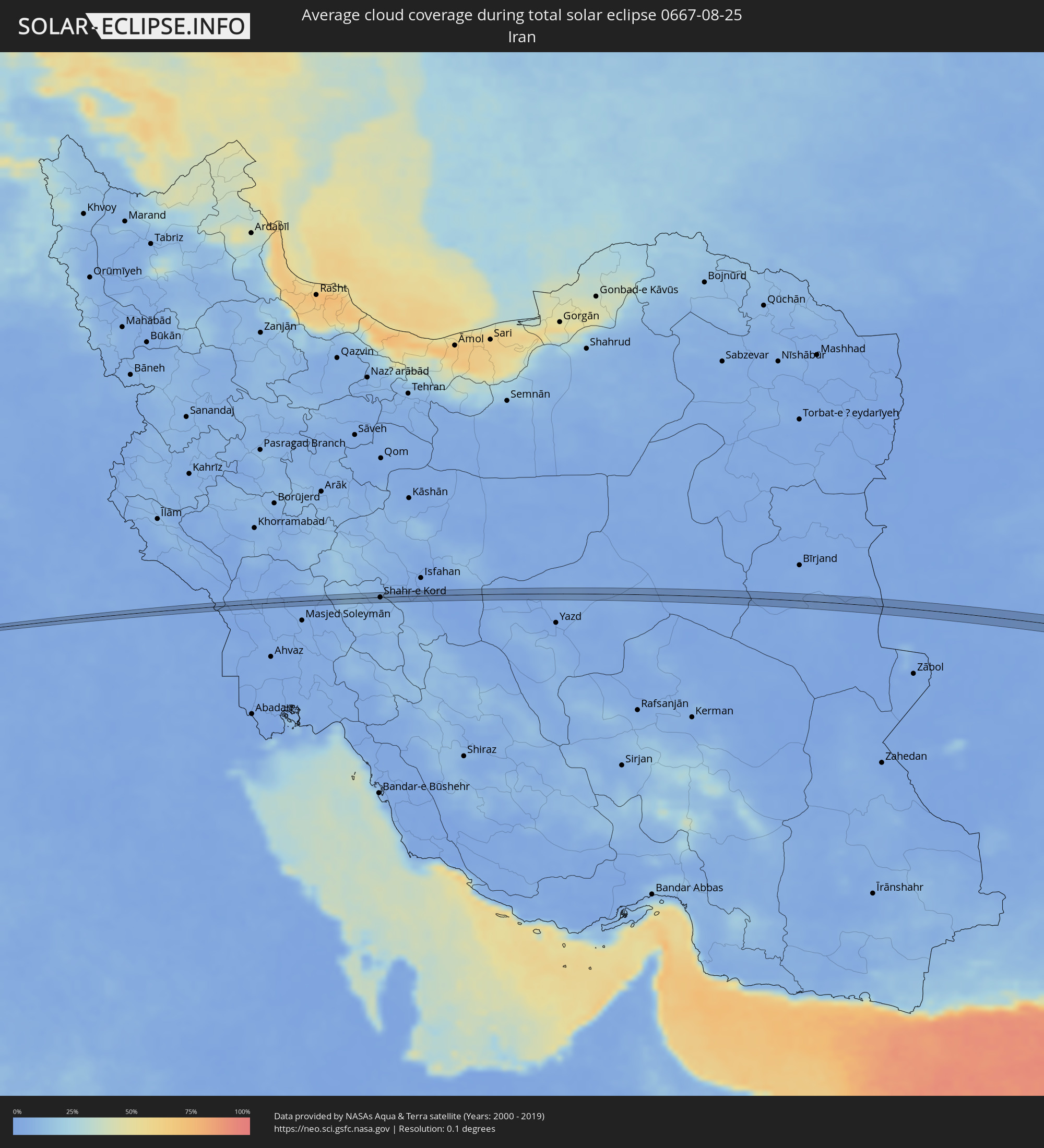 Iran
Iran
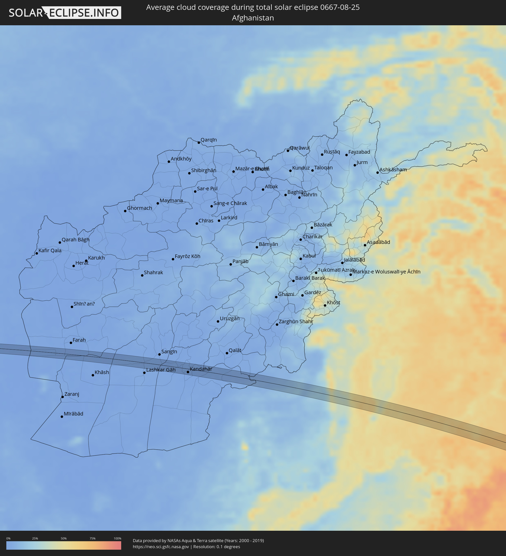 Afghanistan
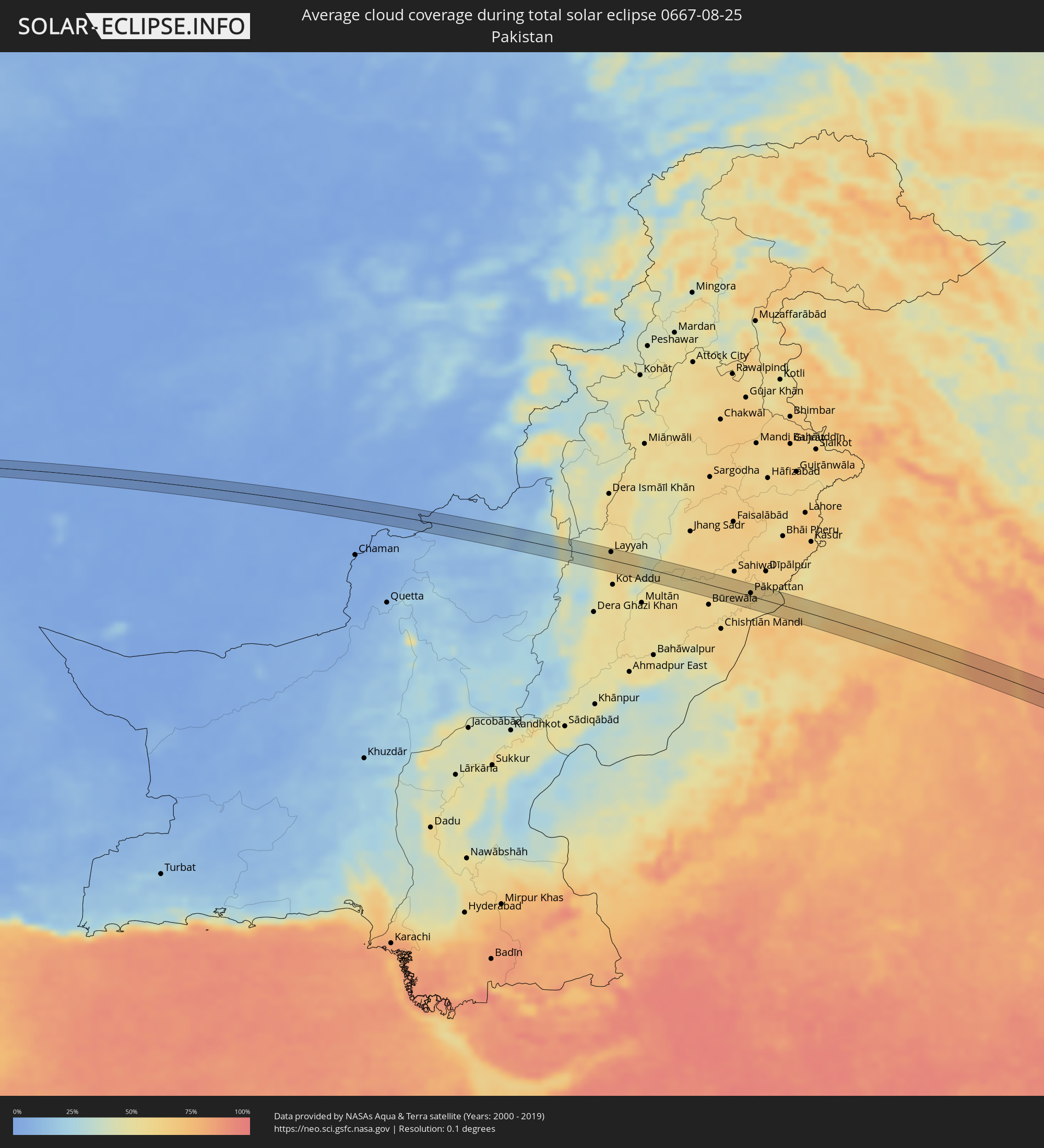 Pakistan
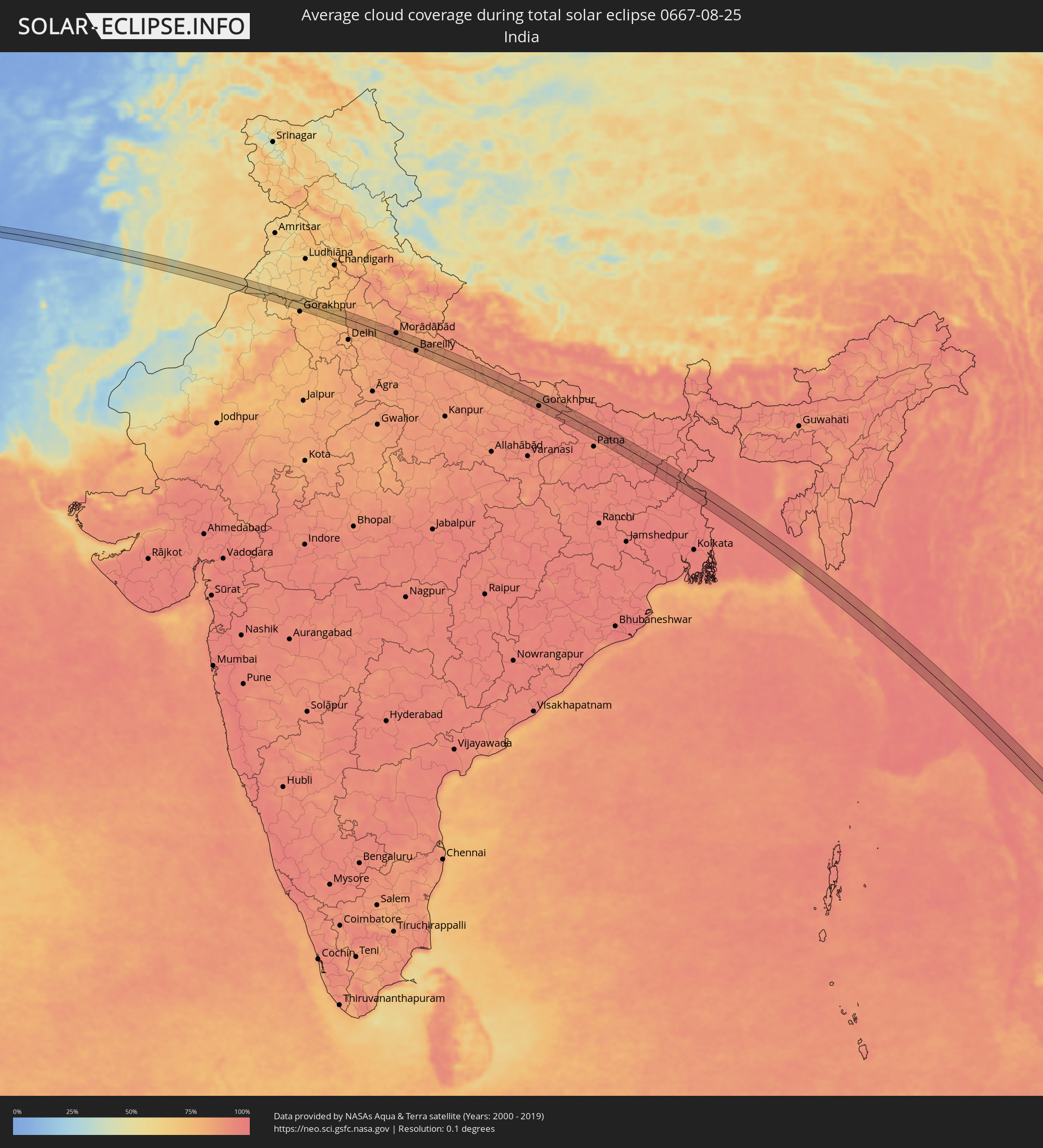 India
India
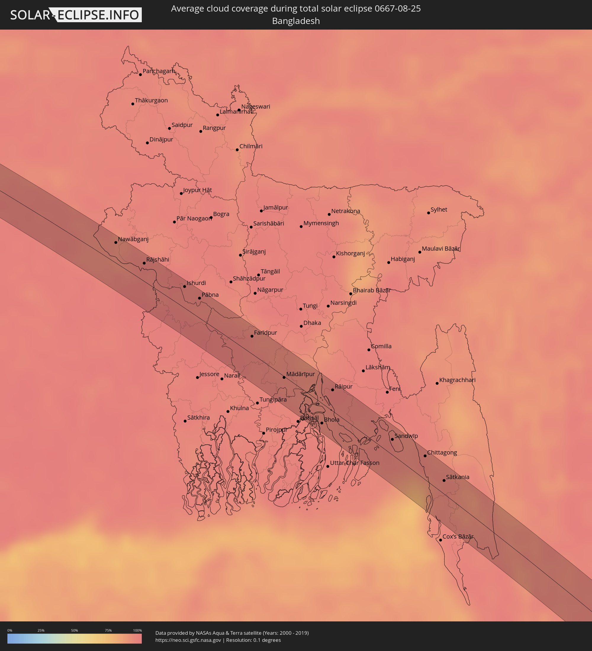 Bangladesh
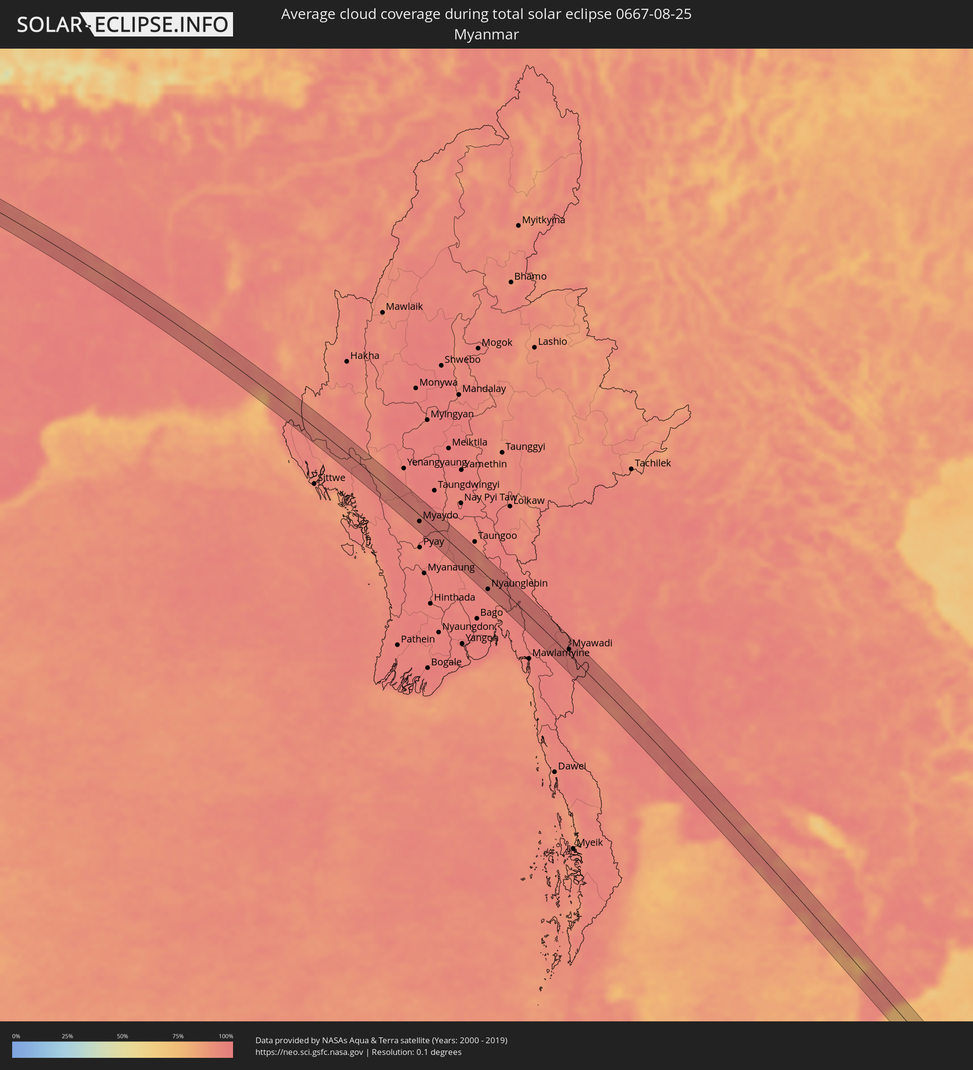 Myanmar
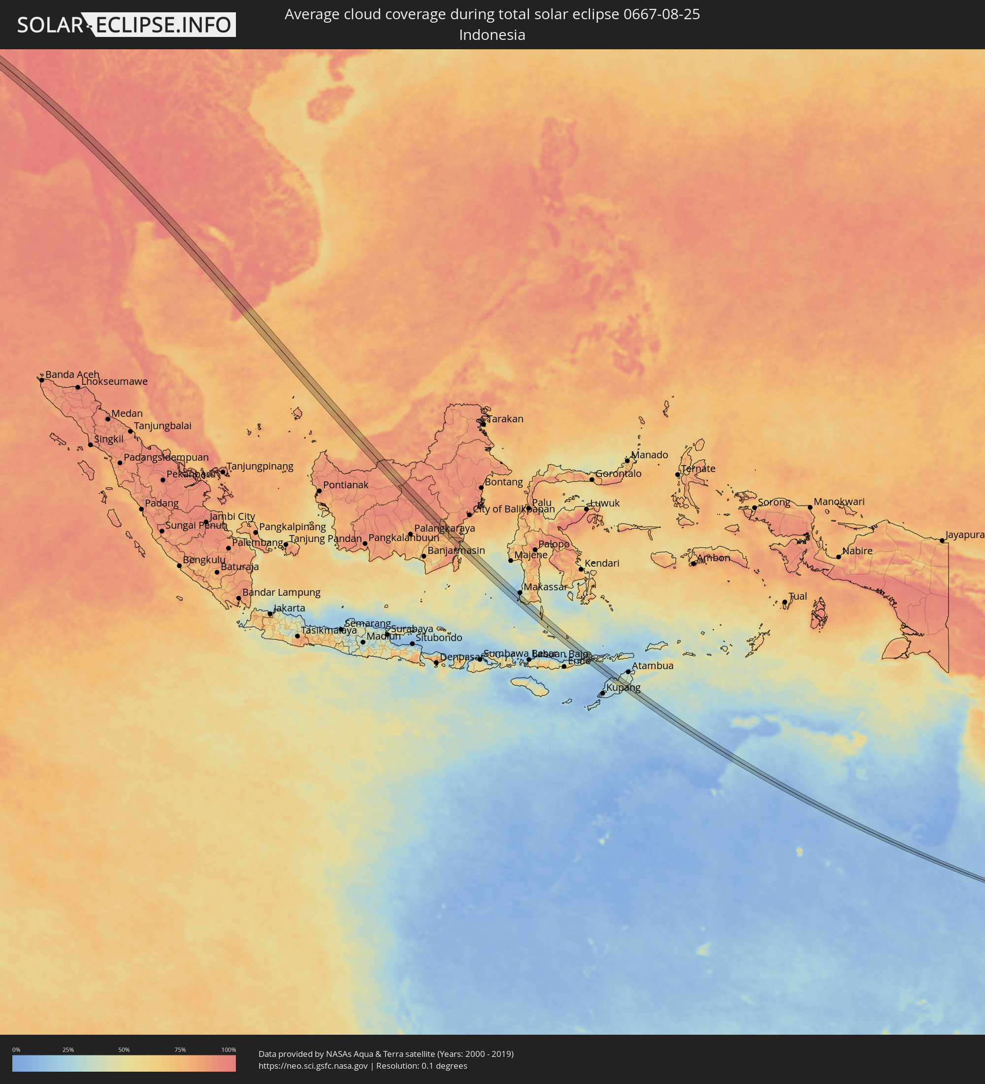 Indonesia
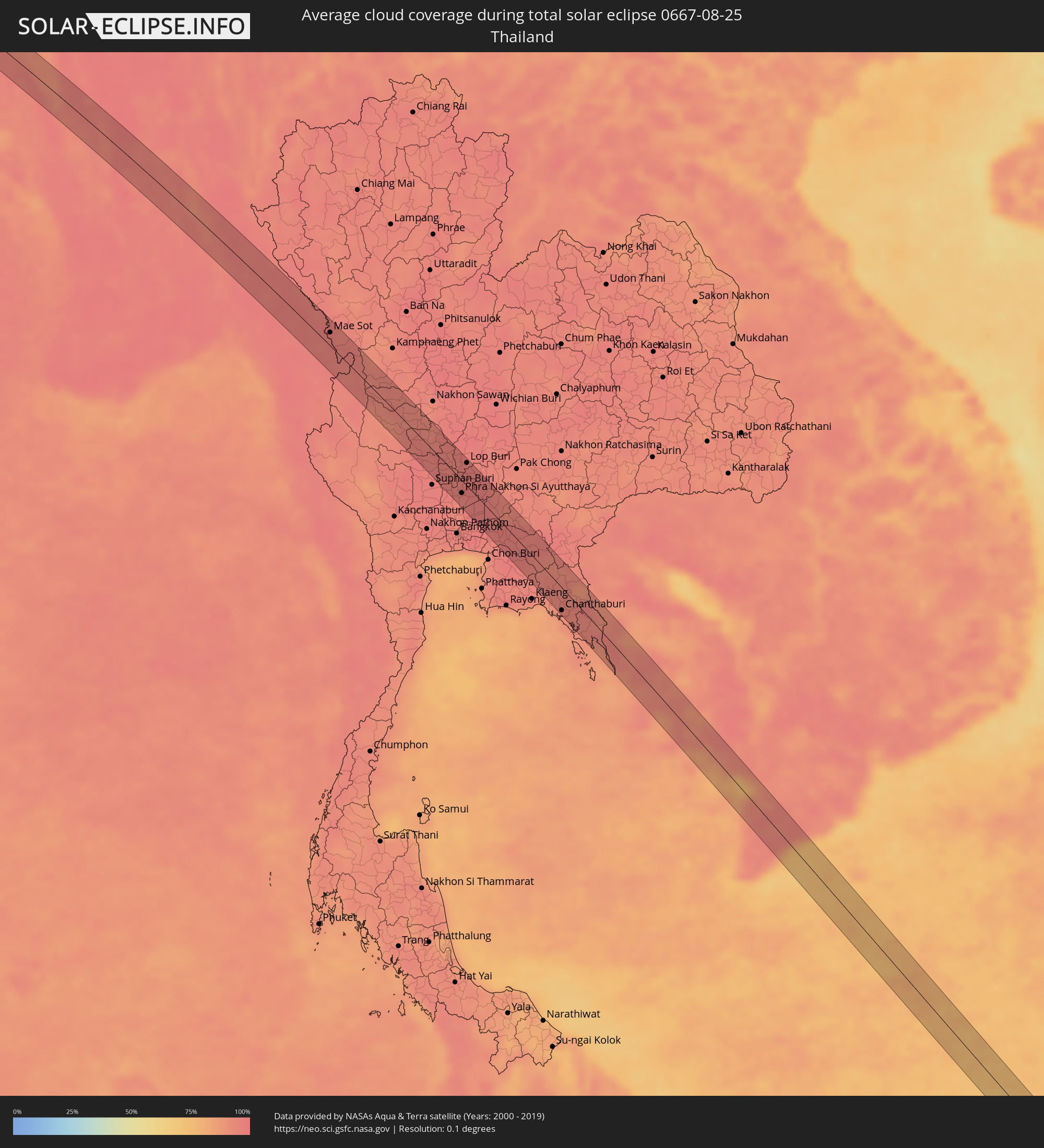 Thailand
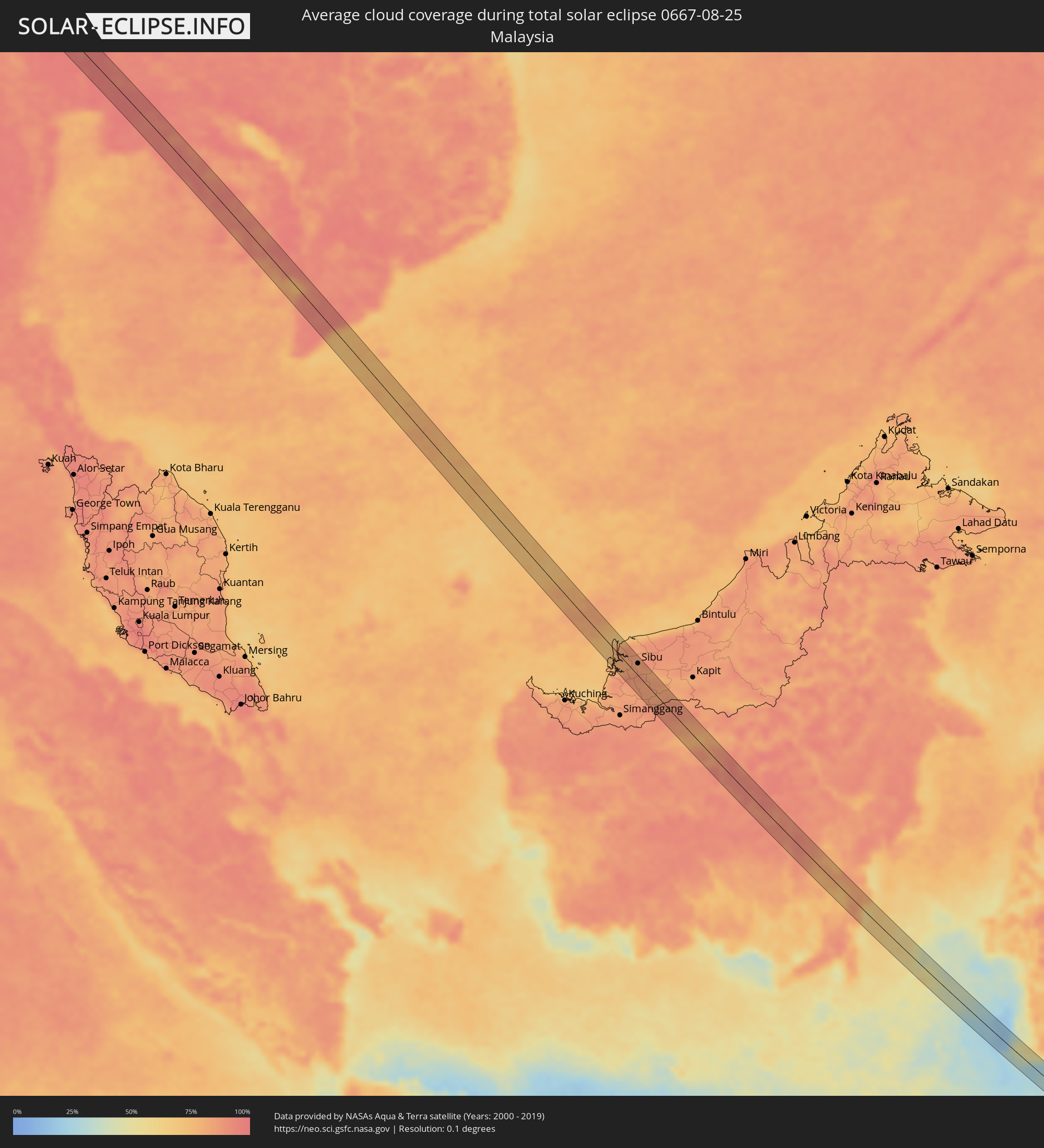 Malaysia
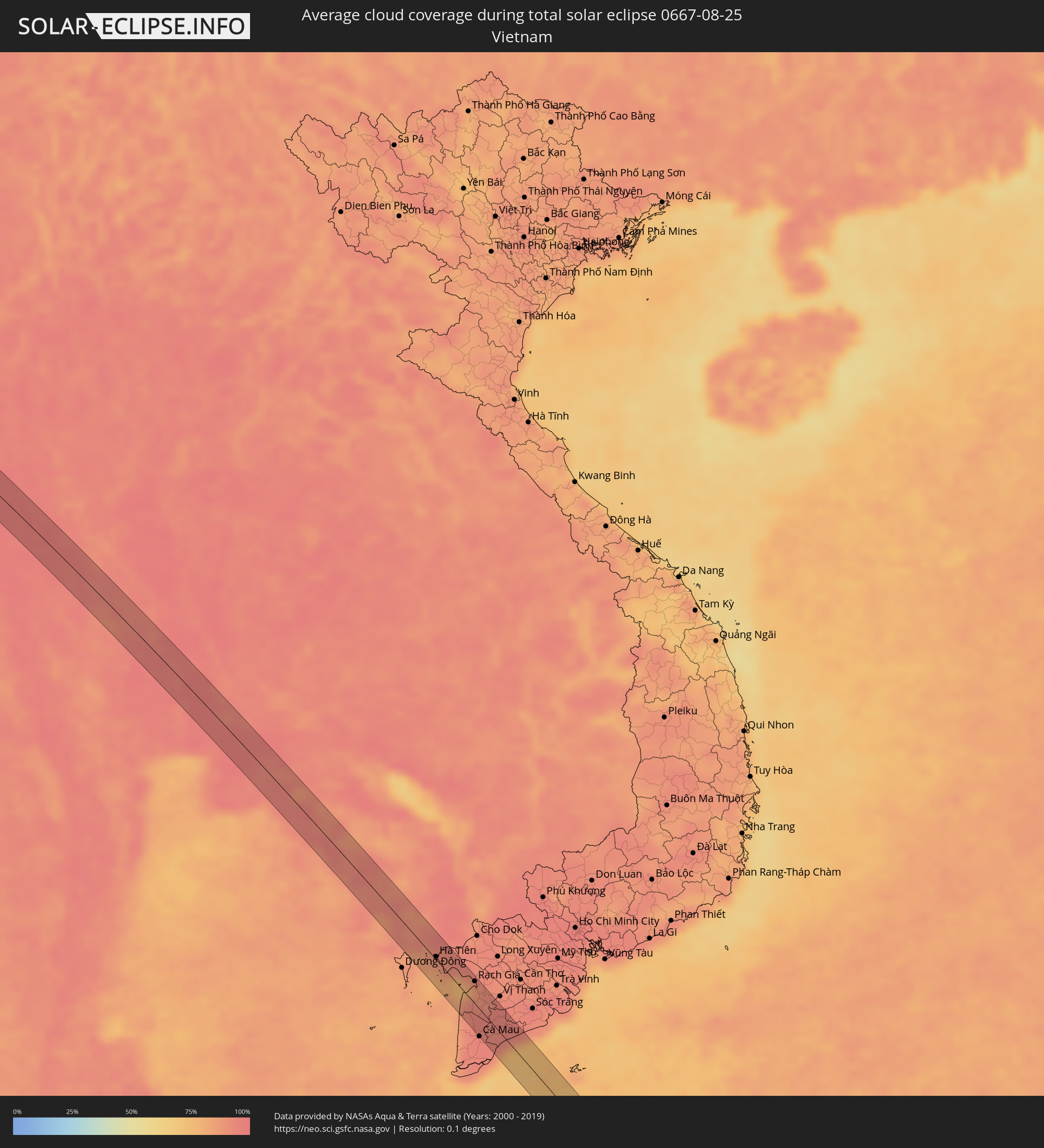 Vietnam
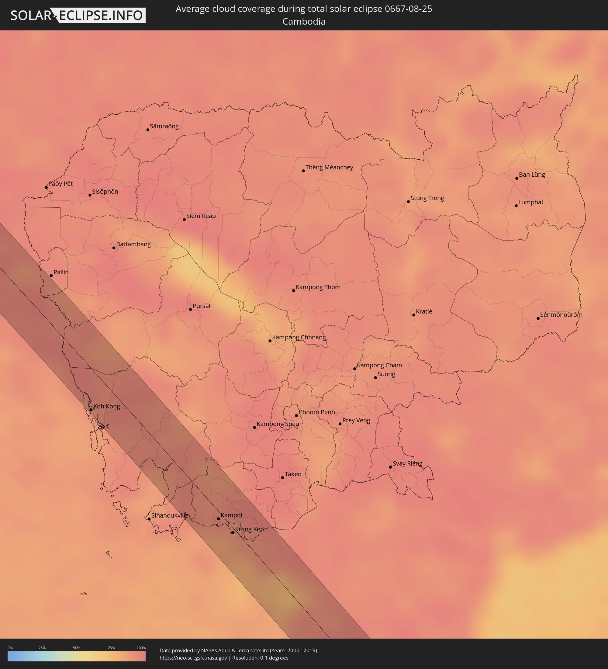 Cambodia
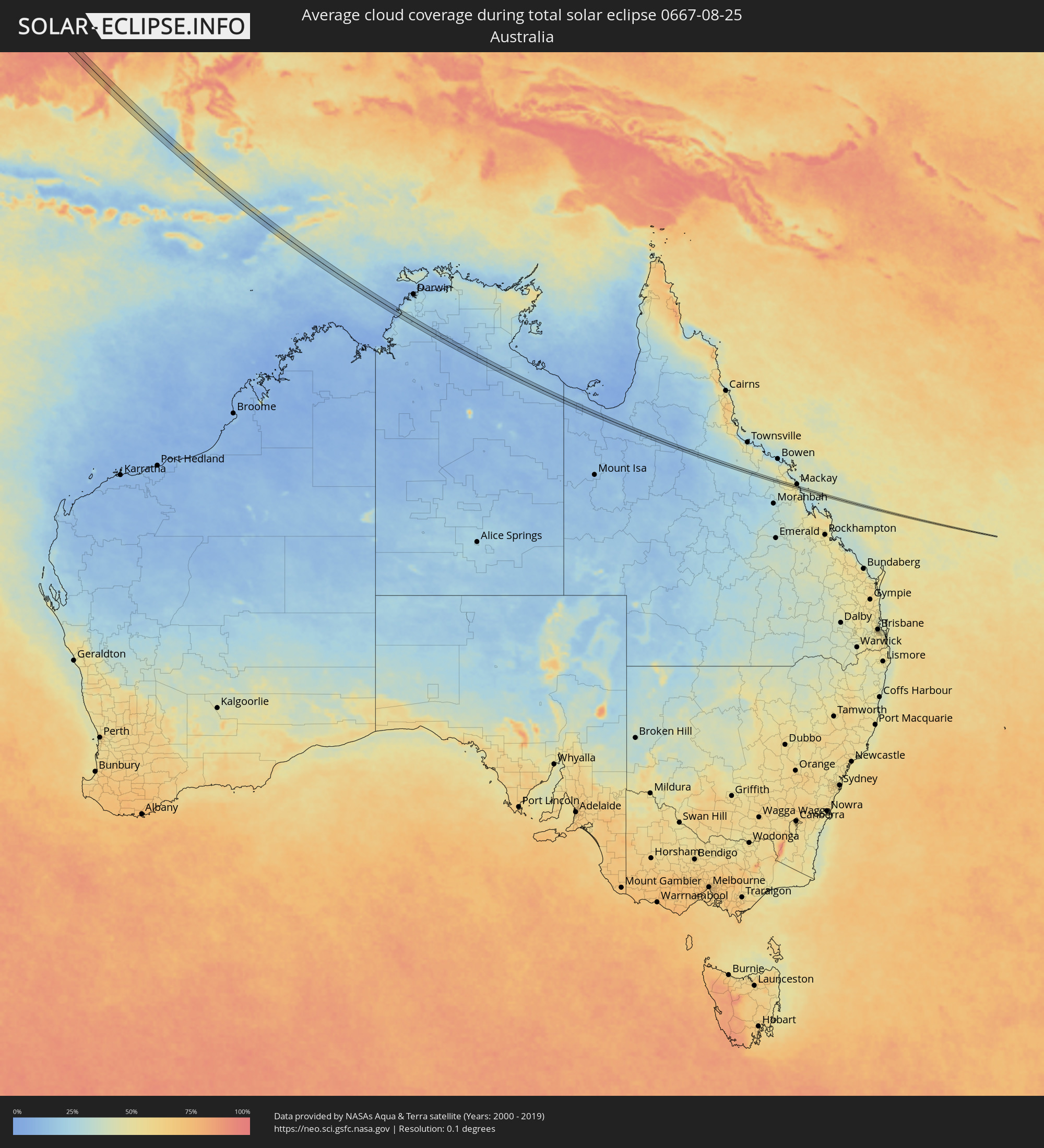 Australia
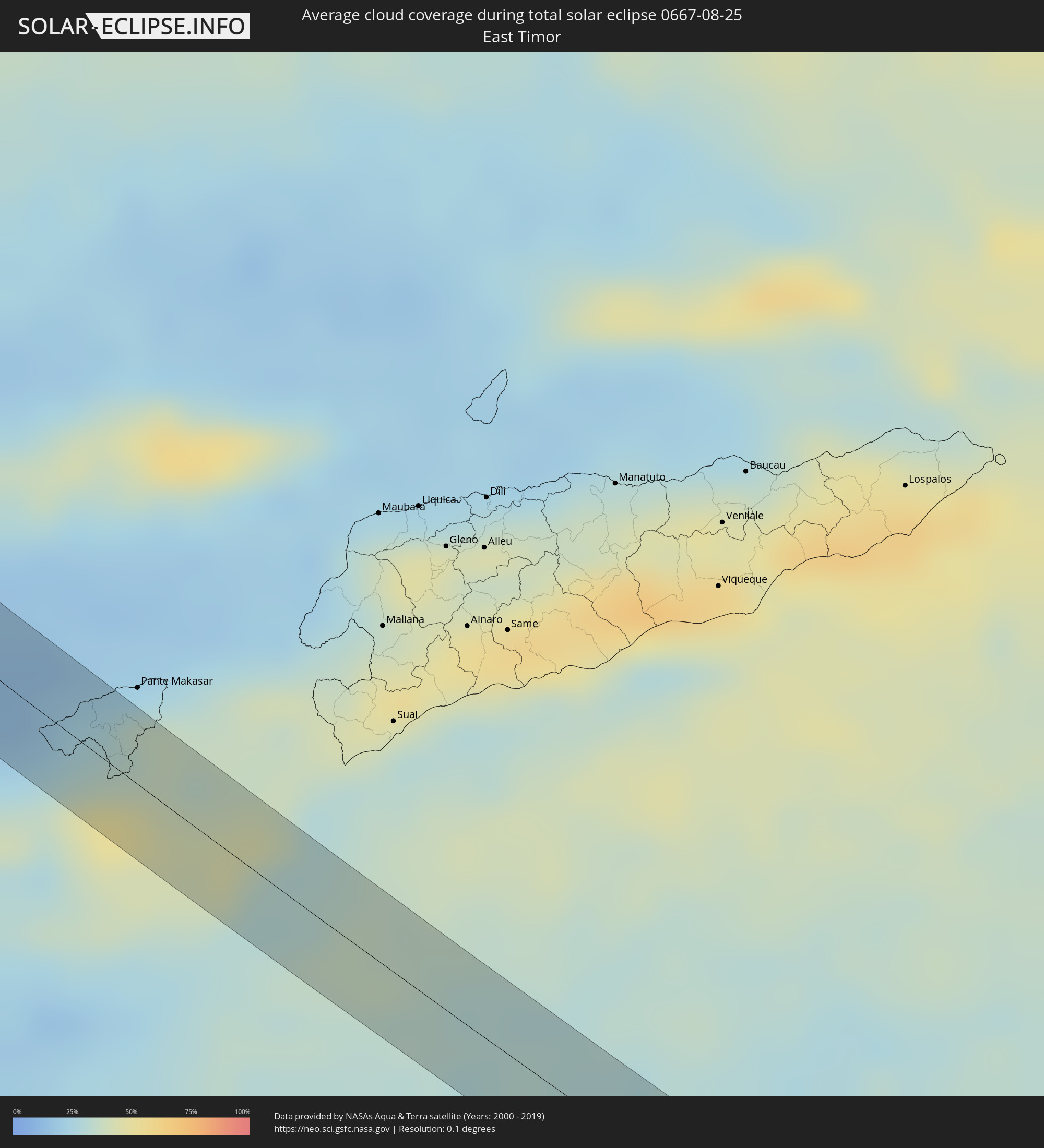 East Timor
Cities inside the path of the eclipse
The following table shows all locations with a population of more than 5,000 inside the eclipse path. Cities which have more than 100,000 inhabitants are marked bold. A click at the locations opens a detailed map.
| City | Type | Eclipse duration | Local time of max. eclipse | Distance to central line | Ø Cloud coverage |
|
Aţ Ţafīlah, Tafielah
|
total | - | 05:55:28 UTC+02:23 | 2 km | 0% |
|
Ash Shāmīyah, Al Qādisīyah
|
total | - | 06:31:31 UTC+02:57 | 2 km | 3% |
|
Ad Dīwānīyah, Al Qādisīyah
|
total | - | 06:31:39 UTC+02:57 | 2 km | 3% |
|
‘Afak, Al Qādisīyah
|
total | - | 06:31:47 UTC+02:57 | 7 km | 2% |
|
Shūsh, Khuzestan
|
total | - | 07:01:12 UTC+03:25 | 2 km | 2% |
|
Fārsān, Chahār Maḩāll va Bakhtīārī
|
total | - | 07:02:24 UTC+03:25 | 7 km | 8% |
|
Shahr-e Kord, Chahār Maḩāll va Bakhtīārī
|
total | - | 07:02:35 UTC+03:25 | 1 km | 7% |
|
Farrokh Shahr, Chahār Maḩāll va Bakhtīārī
|
total | - | 07:02:38 UTC+03:25 | 7 km | 7% |
|
Ardakān, Yazd
|
total | - | 07:04:32 UTC+03:25 | 9 km | 3% |
|
Gereshk, Helmand
|
total | - | 07:48:03 UTC+04:00 | 2 km | 2% |
|
Kandahār, Kandahar
|
total | - | 07:49:20 UTC+04:00 | 10 km | 1% |
|
Kot Sultan, Punjab
|
total | - | 08:24:13 UTC+04:28 | 8 km | 56% |
|
Layyah, Punjab
|
total | - | 08:24:09 UTC+04:28 | 13 km | 55% |
|
Ahmadpur Siāl, Punjab
|
total | - | 08:25:22 UTC+04:28 | 0 km | 50% |
|
Sarāi Sidhu, Punjab
|
total | - | 08:25:42 UTC+04:28 | 3 km | 54% |
|
Talamba, Punjab
|
total | - | 08:26:06 UTC+04:28 | 4 km | 56% |
|
Miān Channūn, Punjab
|
total | - | 08:26:18 UTC+04:28 | 11 km | 58% |
|
Hasan Abdāl, Punjab
|
total | - | 08:26:48 UTC+04:28 | 3 km | 60% |
|
Chīchāwatni, Punjab
|
total | - | 08:26:45 UTC+04:28 | 8 km | 59% |
|
Kamīr, Punjab
|
total | - | 08:27:17 UTC+04:28 | 6 km | 60% |
|
Ārifwāla, Punjab
|
total | - | 08:27:23 UTC+04:28 | 8 km | 57% |
|
Pākpattan, Punjab
|
total | - | 08:27:49 UTC+04:28 | 5 km | 60% |
|
Minchinābād, Punjab
|
total | - | 08:28:10 UTC+04:28 | 10 km | 57% |
|
Jīnd, Haryana
|
total | - | 09:25:46 UTC+05:21 | 20 km | 75% |
|
Pānīpat, Haryana
|
total | - | 09:26:44 UTC+05:21 | 8 km | 77% |
|
Meerut, Uttar Pradesh
|
total | - | 09:28:12 UTC+05:21 | 10 km | 82% |
|
Amroha, Uttar Pradesh
|
total | - | 09:29:30 UTC+05:21 | 8 km | 86% |
|
Sambhal, Uttar Pradesh
|
total | - | 09:29:55 UTC+05:21 | 22 km | 86% |
|
Morādābād, Uttar Pradesh
|
total | - | 09:30:03 UTC+05:21 | 12 km | 84% |
|
Rāmpur, Uttar Pradesh
|
total | - | 09:30:30 UTC+05:21 | 18 km | 84% |
|
Bareilly, Uttar Pradesh
|
total | - | 09:31:32 UTC+05:21 | 16 km | 85% |
|
Lakhīmpur, Uttar Pradesh
|
total | - | 09:34:12 UTC+05:21 | 4 km | 85% |
|
Bahraigh, Uttar Pradesh
|
total | - | 09:35:58 UTC+05:21 | 9 km | 88% |
|
Gorakhpur, Uttar Pradesh
|
total | - | 09:39:59 UTC+05:21 | 14 km | 90% |
|
Muzaffarpur, Bihar
|
total | - | 09:44:27 UTC+05:21 | 17 km | 95% |
|
Monghyr, Bihar
|
total | - | 09:47:27 UTC+05:21 | 1 km | 93% |
|
Bhāgalpur, Bihar
|
total | - | 09:48:34 UTC+05:21 | 12 km | 96% |
|
Baharampur, West Bengal
|
total | - | 09:52:39 UTC+05:21 | 27 km | 97% |
|
Nawābganj, Rājshāhi
|
total | - | 10:24:09 UTC+05:53 | 20 km | 92% |
|
Rājshāhi, Rājshāhi
|
total | - | 10:25:06 UTC+05:53 | 18 km | 96% |
|
Ishurdi, Rājshāhi
|
total | - | 10:26:22 UTC+05:53 | 21 km | 95% |
|
Kushtia, Khulna
|
total | - | 10:26:49 UTC+05:53 | 3 km | 97% |
|
Pābna, Rājshāhi
|
total | - | 10:26:53 UTC+05:53 | 19 km | 95% |
|
Farīdpur, Dhaka
|
total | - | 10:28:41 UTC+05:53 | 17 km | 96% |
|
Mādārīpur, Dhaka
|
total | - | 10:30:06 UTC+05:53 | 1 km | 93% |
|
Pālang, Dhaka
|
total | - | 10:30:18 UTC+05:53 | 11 km | 94% |
|
Bhola, Barisāl
|
total | - | 10:31:44 UTC+05:53 | 19 km | 94% |
|
Rāipur, Chittagong
|
total | - | 10:31:25 UTC+05:53 | 20 km | 96% |
|
Lakshmīpur, Chittagong
|
total | - | 10:31:42 UTC+05:53 | 15 km | 94% |
|
Sandwīp, Chittagong
|
total | - | 10:33:39 UTC+05:53 | 15 km | 94% |
|
Chittagong, Chittagong
|
total | - | 10:34:42 UTC+05:53 | 22 km | 91% |
|
Patiya, Chittagong
|
total | - | 10:35:04 UTC+05:53 | 28 km | 95% |
|
Sātkania, Chittagong
|
total | - | 10:35:35 UTC+05:53 | 13 km | 94% |
|
Thayetmyo, Magway
|
total | - | 11:18:24 UTC+06:24 | 17 km | 93% |
|
Myaydo, Magway
|
total | - | 11:18:22 UTC+06:24 | 11 km | 94% |
|
Pyu, Bago
|
total | - | 11:22:36 UTC+06:24 | 2 km | 96% |
|
Nyaunglebin, Bago
|
total | - | 11:24:14 UTC+06:24 | 21 km | 95% |
|
Myawadi, Kayin
|
total | - | 11:30:28 UTC+06:24 | 9 km | 97% |
|
Mae Sot, Tak
|
total | - | 11:47:49 UTC+06:42 | 15 km | 97% |
|
Uthai Thani, Uthai Thani
|
total | - | 11:53:35 UTC+06:42 | 22 km | 93% |
|
Phak Hai, Phra Nakhon Si Ayutthaya
|
total | - | 11:56:15 UTC+06:42 | 22 km | 96% |
|
Sing Buri, Sing Buri
|
total | - | 11:55:24 UTC+06:42 | 13 km | 94% |
|
Phra Nakhon Si Ayutthaya, Phra Nakhon Si Ayutthaya
|
total | - | 11:56:54 UTC+06:42 | 14 km | 95% |
|
Khlong Luang, Pathum Thani
|
partial | - | 11:57:40 UTC+06:42 | 31 km | 94% |
|
Lop Buri, Lop Buri
|
total | - | 11:56:06 UTC+06:42 | 26 km | 96% |
|
Ban Lam Luk Ka, Pathum Thani
|
total | - | 11:58:07 UTC+06:42 | 27 km | 96% |
|
Nong Khae, Sara Buri
|
total | - | 11:57:31 UTC+06:42 | 8 km | 96% |
|
Saraburi, Sara Buri
|
total | - | 11:57:12 UTC+06:42 | 26 km | 97% |
|
Chachoengsao, Chachoengsao
|
total | - | 11:59:20 UTC+06:42 | 26 km | 95% |
|
Nakhon Nayok, Nakhon Nayok
|
total | - | 11:58:30 UTC+06:42 | 24 km | 92% |
|
Prachin Buri, Prachin Buri
|
total | - | 11:59:09 UTC+06:42 | 25 km | 95% |
|
Chanthaburi, Chanthaburi
|
total | - | 12:03:46 UTC+06:42 | 25 km | 93% |
|
Trat, Trat
|
total | - | 12:05:23 UTC+06:42 | 20 km | 89% |
|
Koh Kong, Koh Kong
|
total | - | 12:07:42 UTC+06:42 | 29 km | 85% |
|
Smach Mean Chey, Koh Kong
|
total | - | 12:07:57 UTC+06:42 | 29 km | 85% |
|
Kampot, Kampot
|
total | - | 12:12:16 UTC+06:42 | 5 km | 85% |
|
Krong Kep, Kep
|
total | - | 12:12:48 UTC+06:42 | 3 km | 85% |
|
Hà Tiên, Kiến Giang
|
total | - | 12:37:58 UTC+07:06 | 3 km | 87% |
|
Rạch Giá, Kiến Giang
|
total | - | 12:39:55 UTC+07:06 | 25 km | 87% |
|
Cà Mau, Cà Mau
|
total | - | 12:41:55 UTC+07:06 | 30 km | 95% |
|
Thành phố Bạc Liêu, Bạc Liêu
|
total | - | 12:42:45 UTC+07:06 | 26 km | 92% |
|
Sarikei, Sarawak
|
total | - | 13:23:16 UTC+07:21 | 20 km | 88% |
|
Sibu, Sarawak
|
total | - | 13:23:23 UTC+07:21 | 18 km | 82% |
|
Galesong, South Sulawesi
|
total | - | 14:25:15 UTC+07:57 | 13 km | 37% |
|
Kefamenanu, East Nusa Tenggara
|
total | - | 14:37:43 UTC+07:57 | 13 km | 37% |
|
Katherine, Northern Territory
|
total | - | 16:23:18 UTC+09:30 | 6 km | 11% |