Total solar eclipse of 10/06/0720
| Day of week: | Wednesday |
| Maximum duration of eclipse: | 02m32s |
| Maximum width of eclipse path: | 241 km |
| Saros cycle: | 84 |
| Coverage: | 100% |
| Magnitude: | 1.0355 |
| Gamma: | 0.8749 |
Wo kann man die Sonnenfinsternis vom 10/06/0720 sehen?
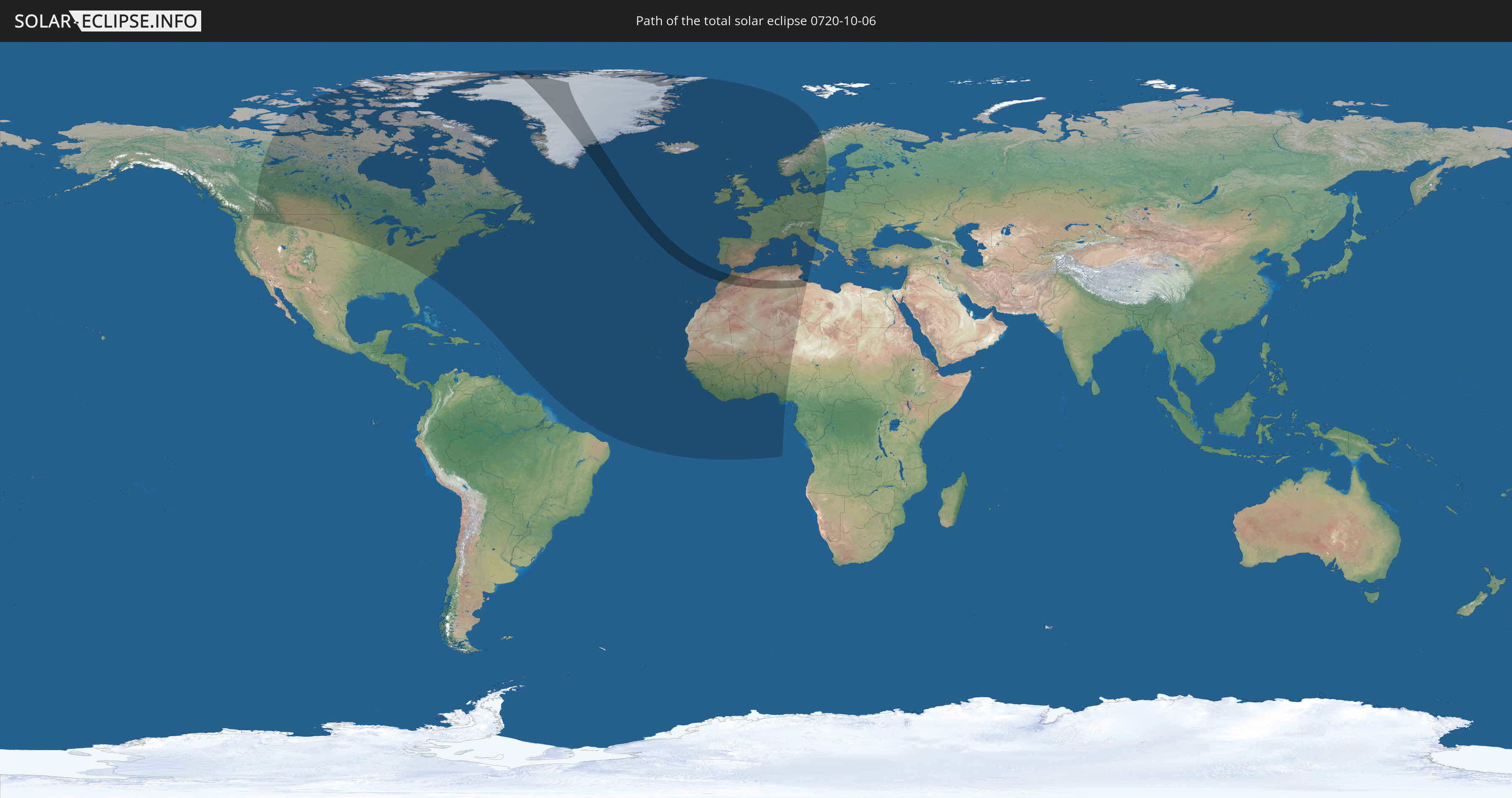
Die Sonnenfinsternis am 10/06/0720 kann man in 60 Ländern als partielle Sonnenfinsternis beobachten.
Der Finsternispfad verläuft durch 5 Länder. Nur in diesen Ländern ist sie als total Sonnenfinsternis zu sehen.
In den folgenden Ländern ist die Sonnenfinsternis total zu sehen
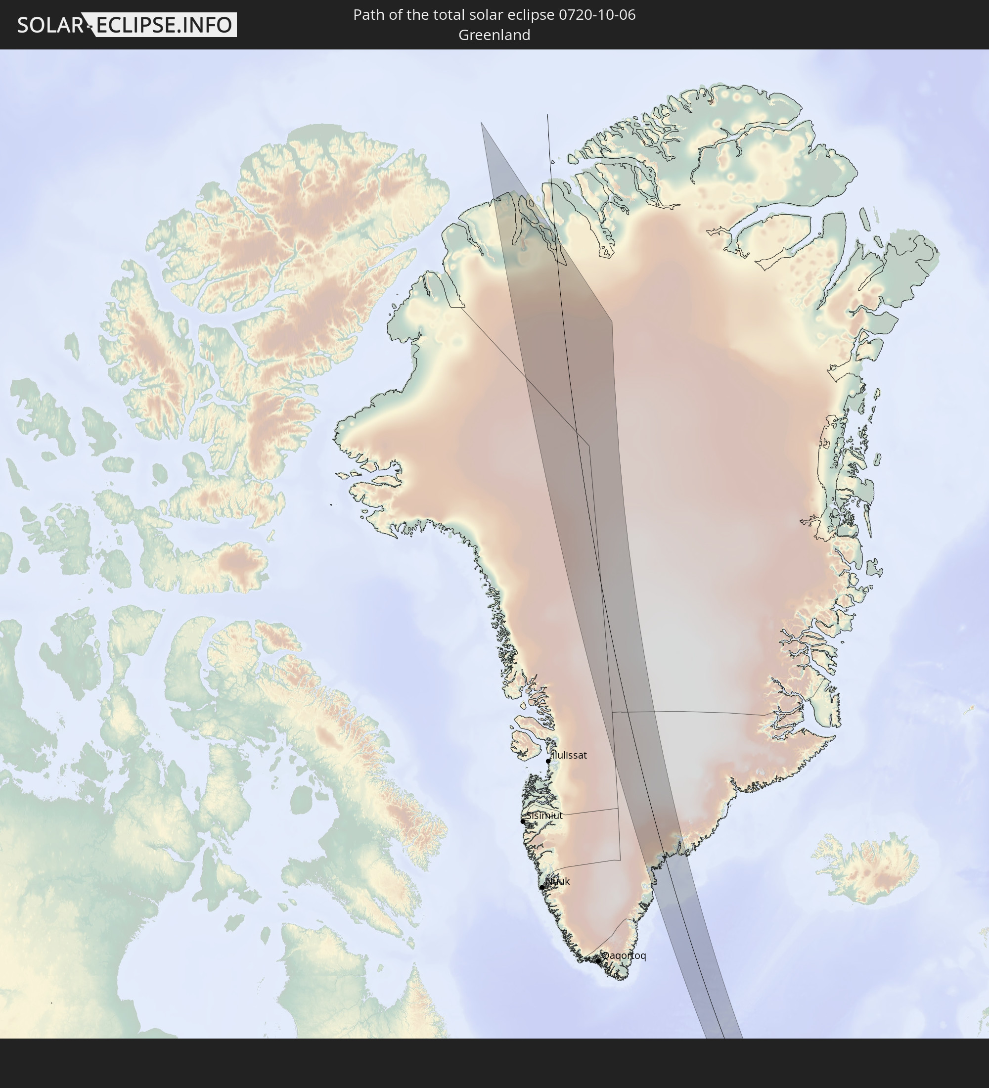 Greenland
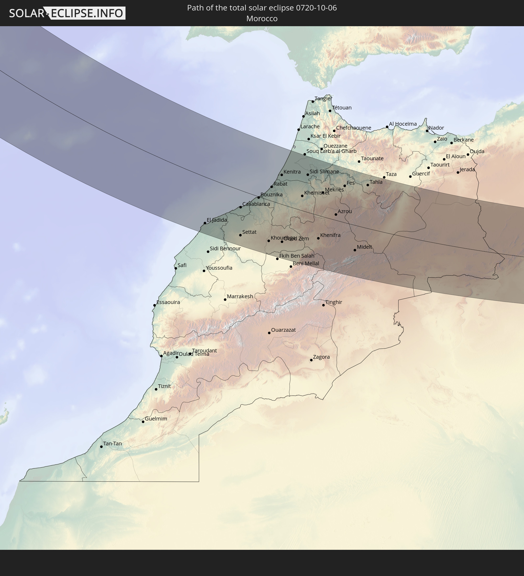 Morocco
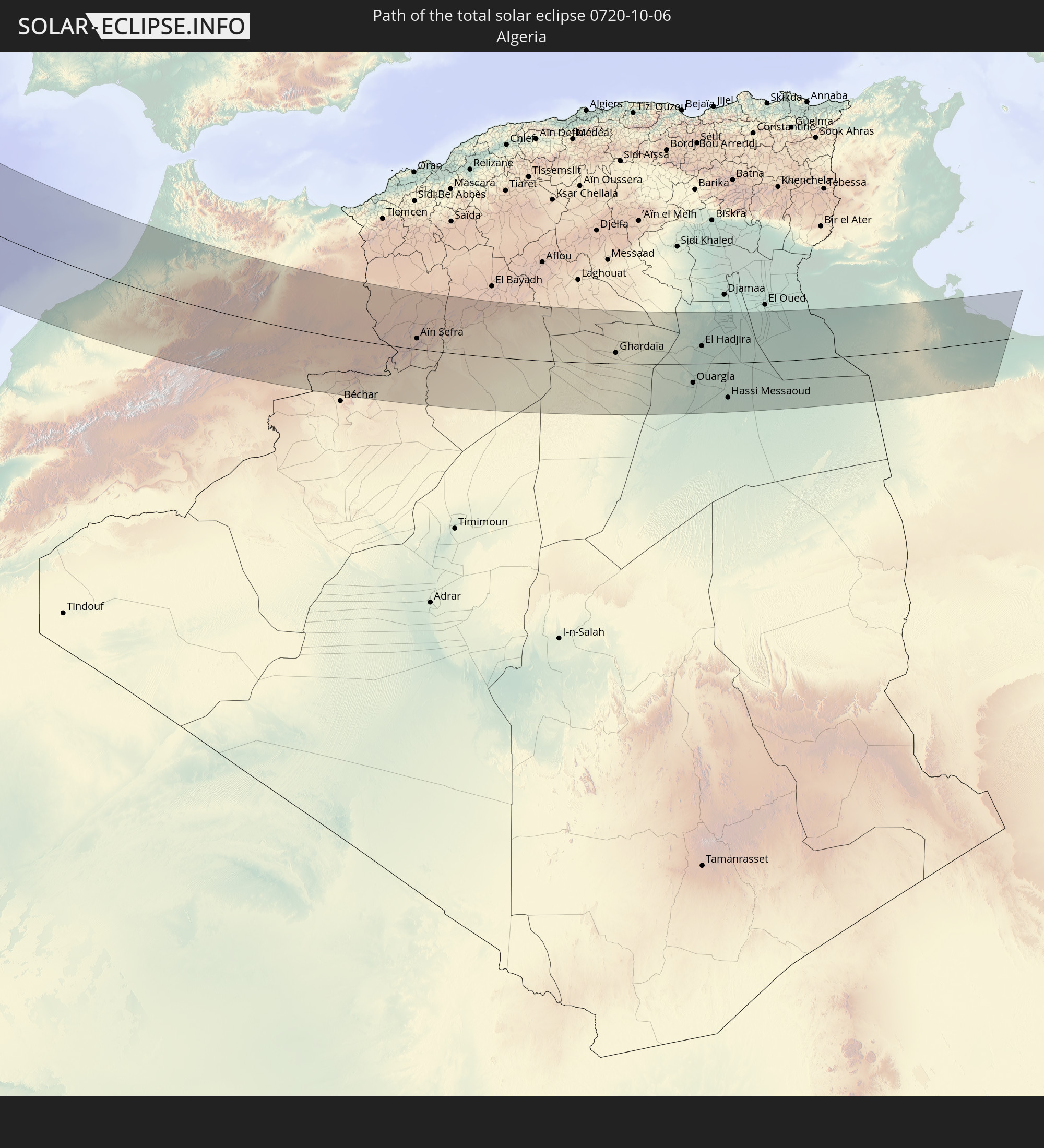 Algeria
 Tunisia
 Libya
Libya
In den folgenden Ländern ist die Sonnenfinsternis partiell zu sehen
 United States
 Canada
 Greenland
 Brazil
 Bermuda
 Saint Pierre and Miquelon
 Portugal
 Cabo Verde
 Iceland
 Spain
Spain
 Senegal
 Mauritania
 The Gambia
 Guinea-Bissau
 Guinea
 Saint Helena, Ascension and Tristan da Cunha
 Sierra Leone
 Morocco
 Mali
Mali
 Liberia
 Republic of Ireland
 Svalbard and Jan Mayen
 Algeria
 United Kingdom
 Ivory Coast
 Faroe Islands
 Burkina Faso
 Gibraltar
 France
 Isle of Man
 Ghana
Ghana
 Guernsey
 Jersey
 Togo
Togo
 Niger
Niger
 Benin
Benin
 Andorra
 Belgium
 Nigeria
 Netherlands
 Norway
 Equatorial Guinea
 Luxembourg
 Germany
 Switzerland
 São Tomé and Príncipe
 Italy
Italy
 Monaco
 Tunisia
 Denmark
 Libya
Libya
 Liechtenstein
 Austria
 Sweden
 Czechia
 San Marino
 Vatican City
 Slovenia
 Croatia
 Poland
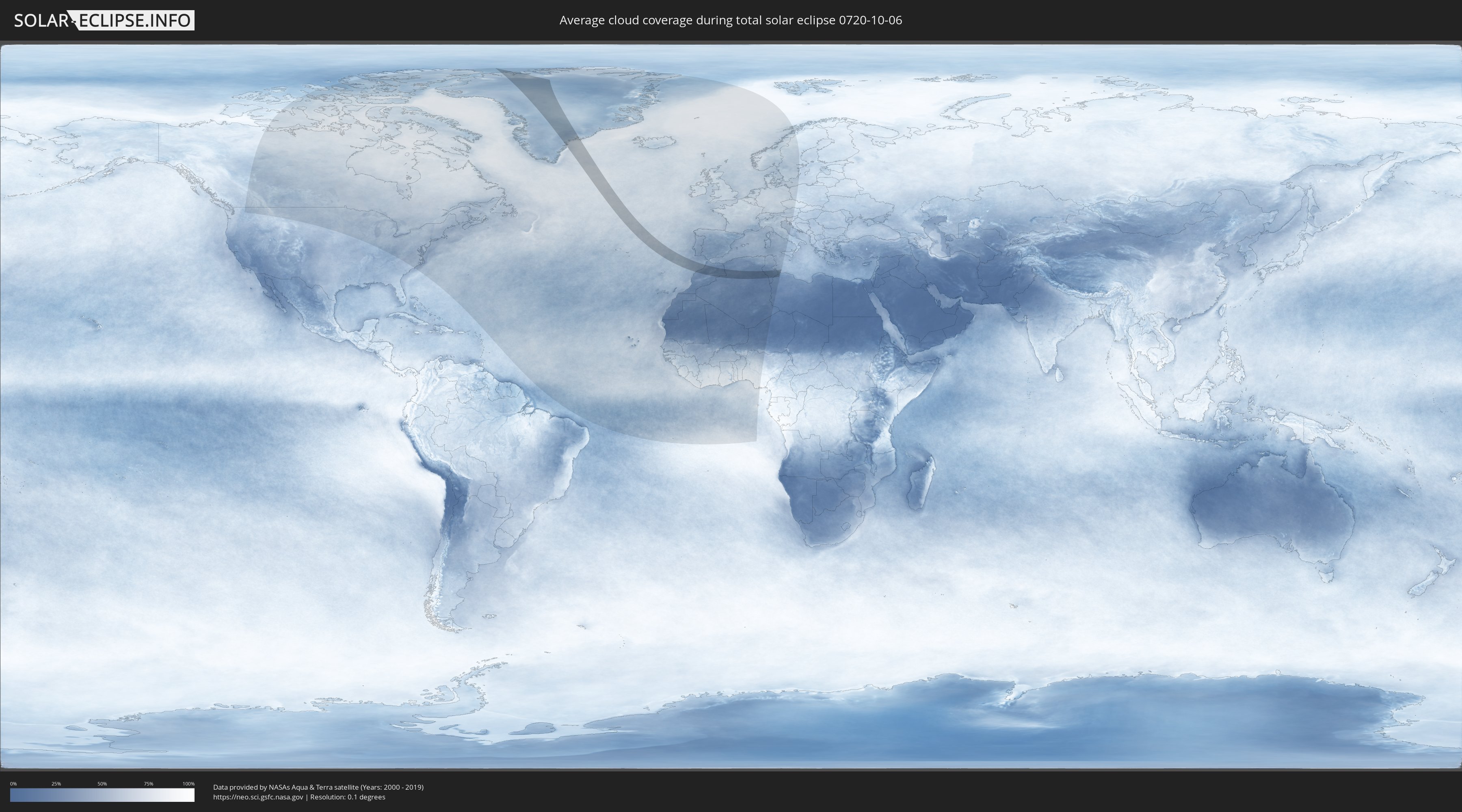
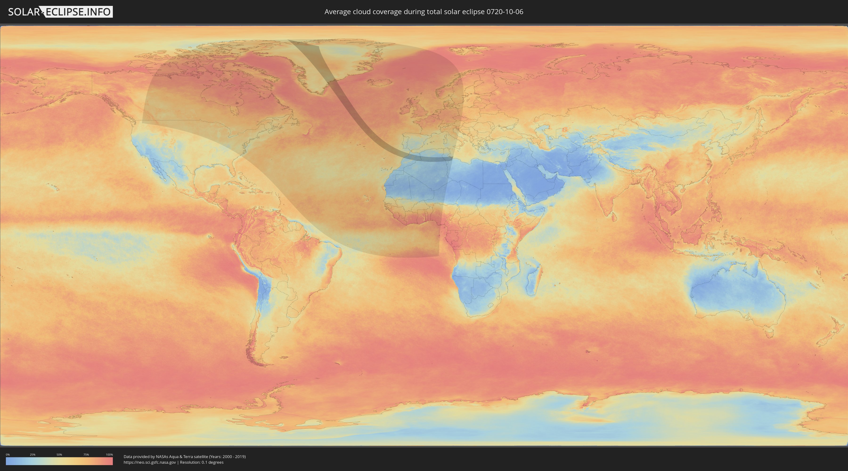
How will be the weather during the total solar eclipse on 10/06/0720?
Where is the best place to see the total solar eclipse of 10/06/0720?
The following maps show the average cloud coverage for the day of the total solar eclipse.
With the help of these maps, it is possible to find the place along the eclipse path, which has the best
chance of a cloudless sky.
Nevertheless, you should consider local circumstances and inform about the weather of your chosen
observation site.
The data is provided by NASAs satellites
AQUA and TERRA.
The cloud maps are averaged over a period of 19 years (2000 - 2019).
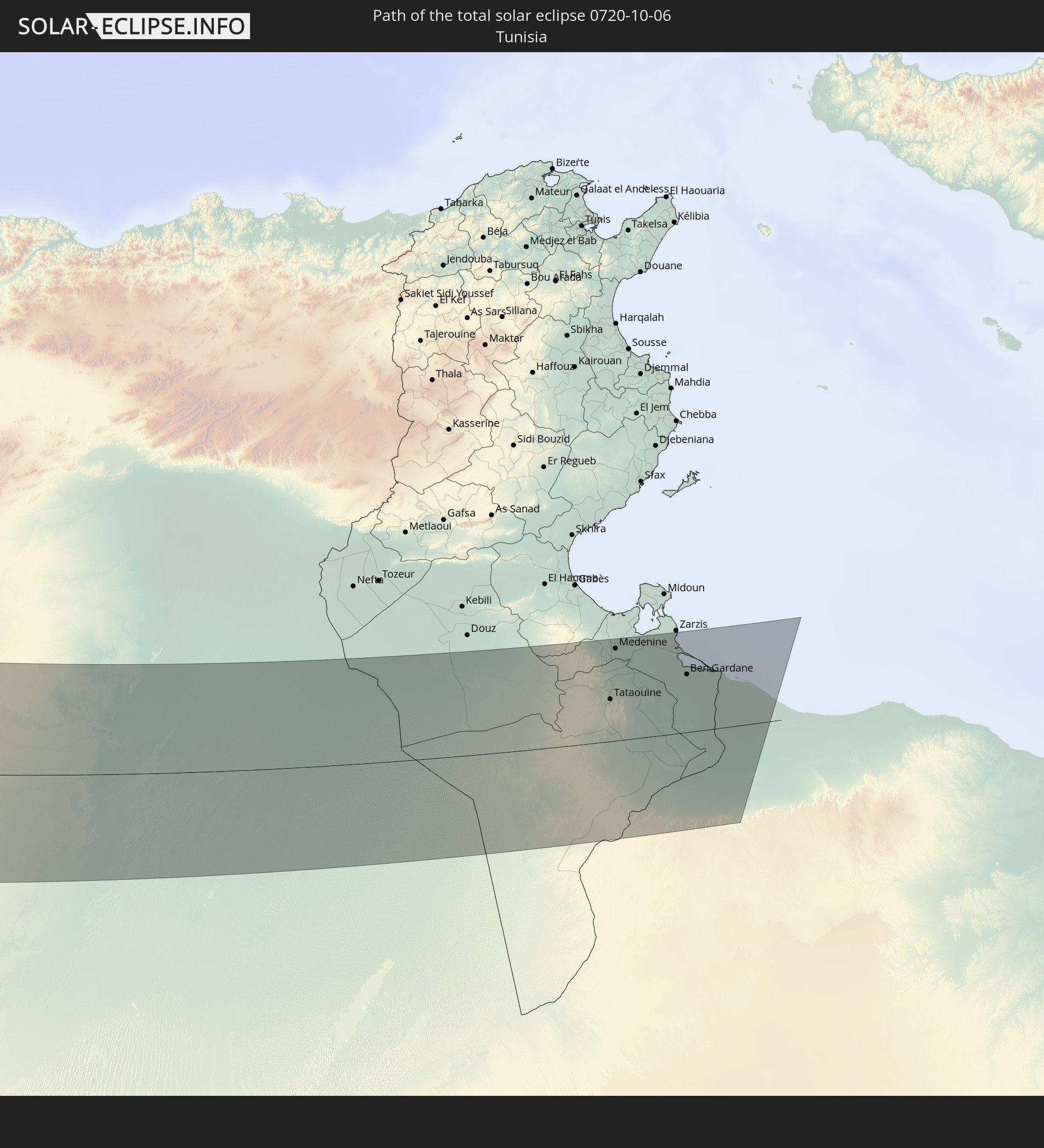
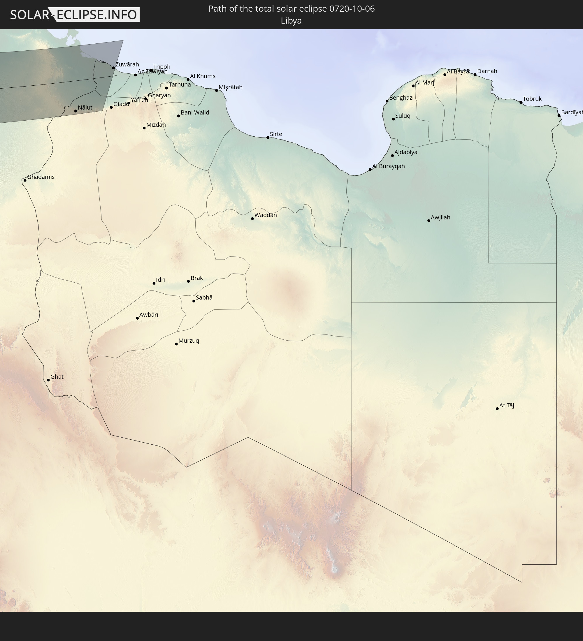
Detailed country maps
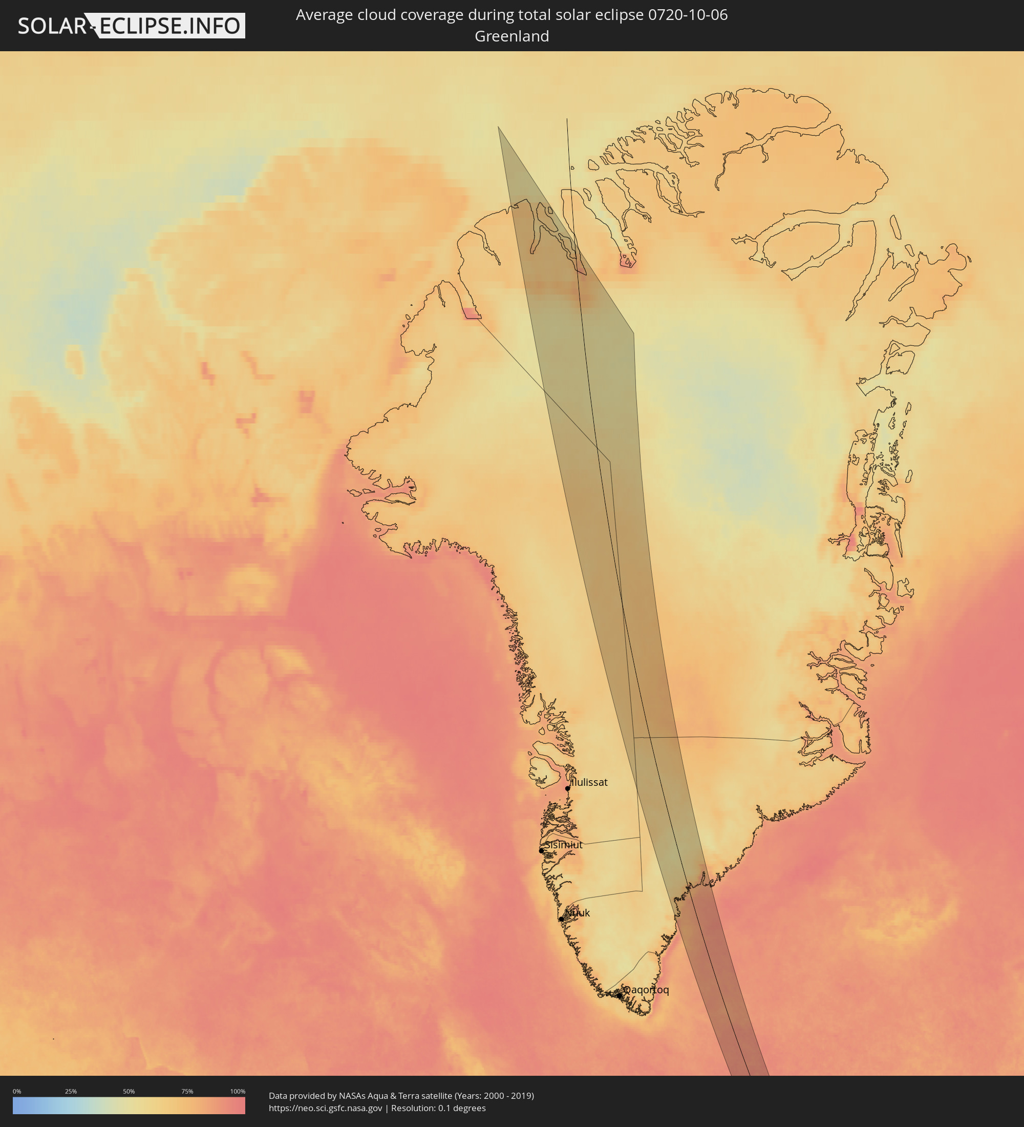 Greenland
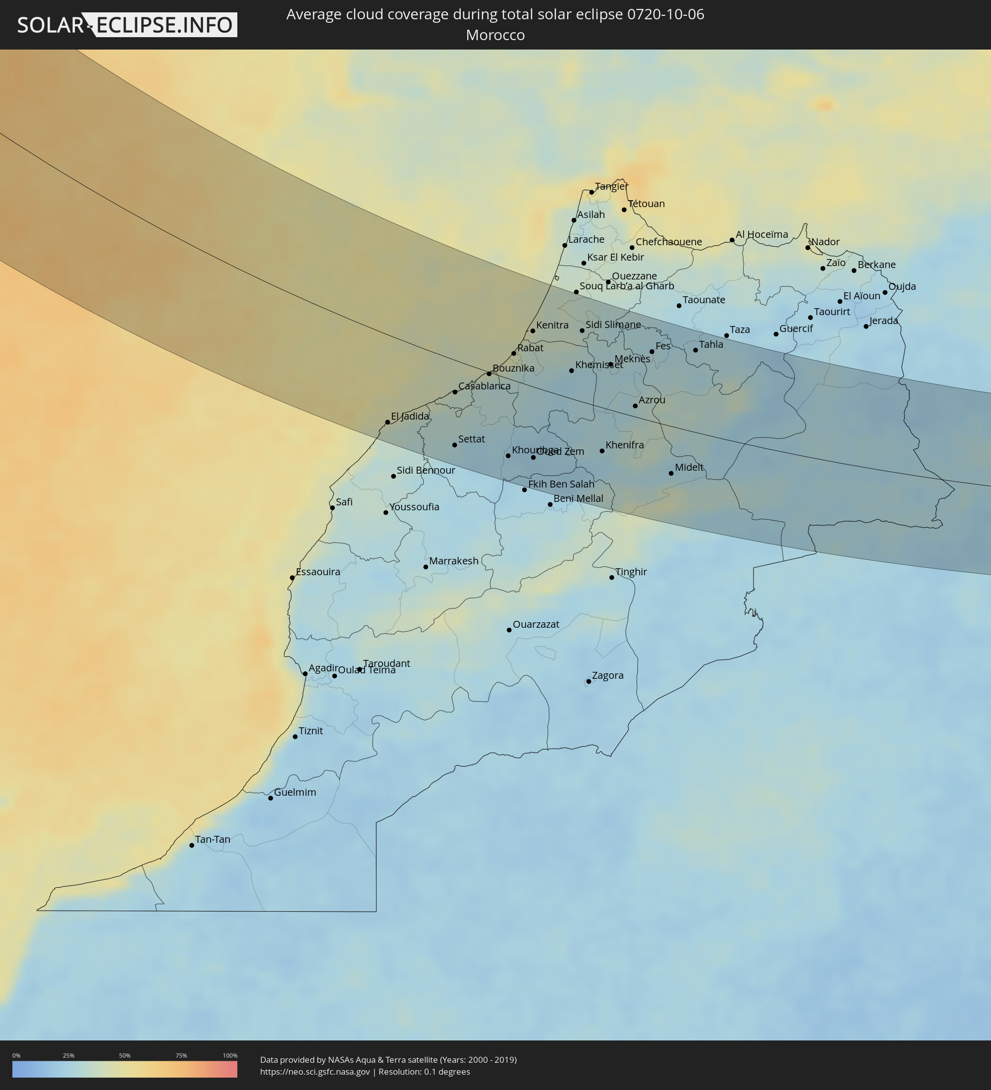 Morocco
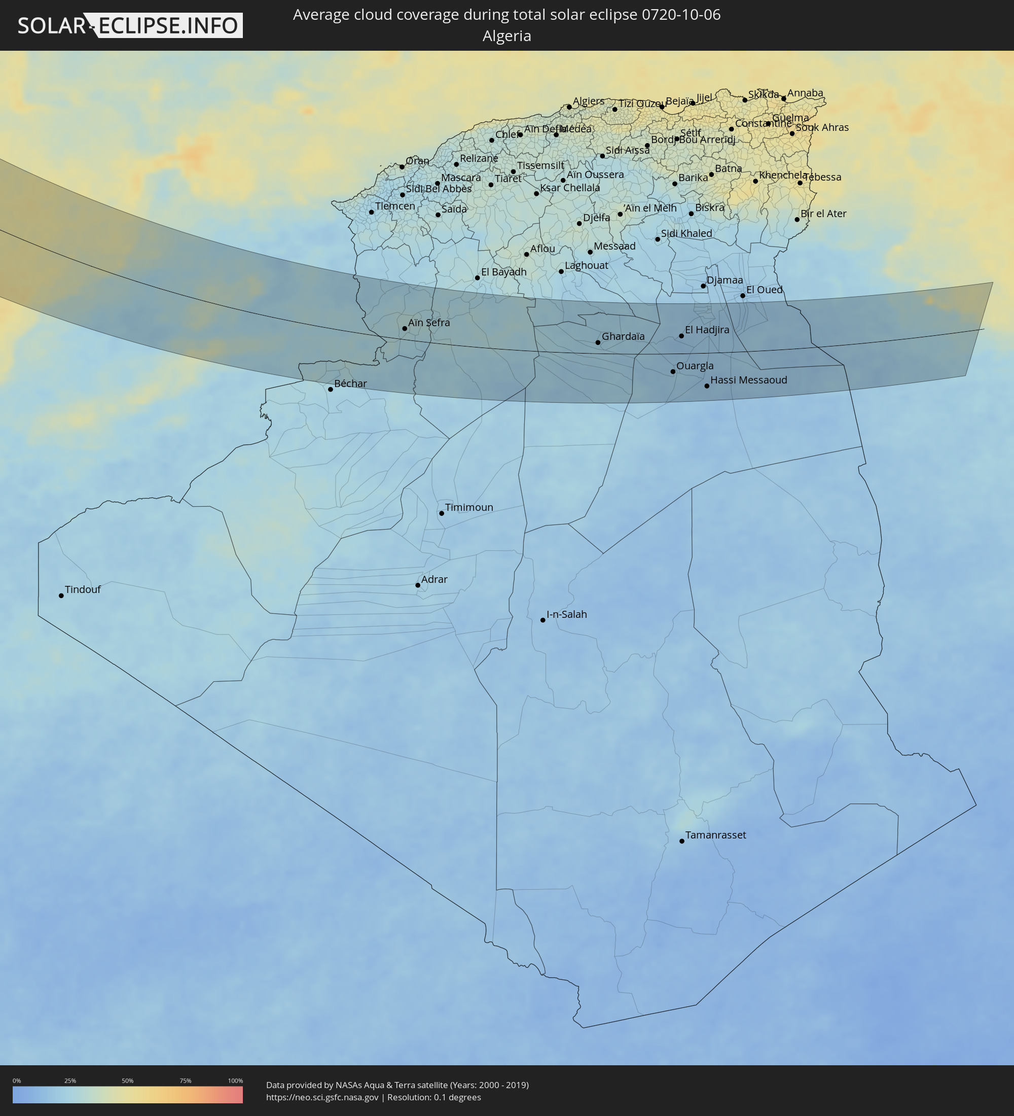 Algeria
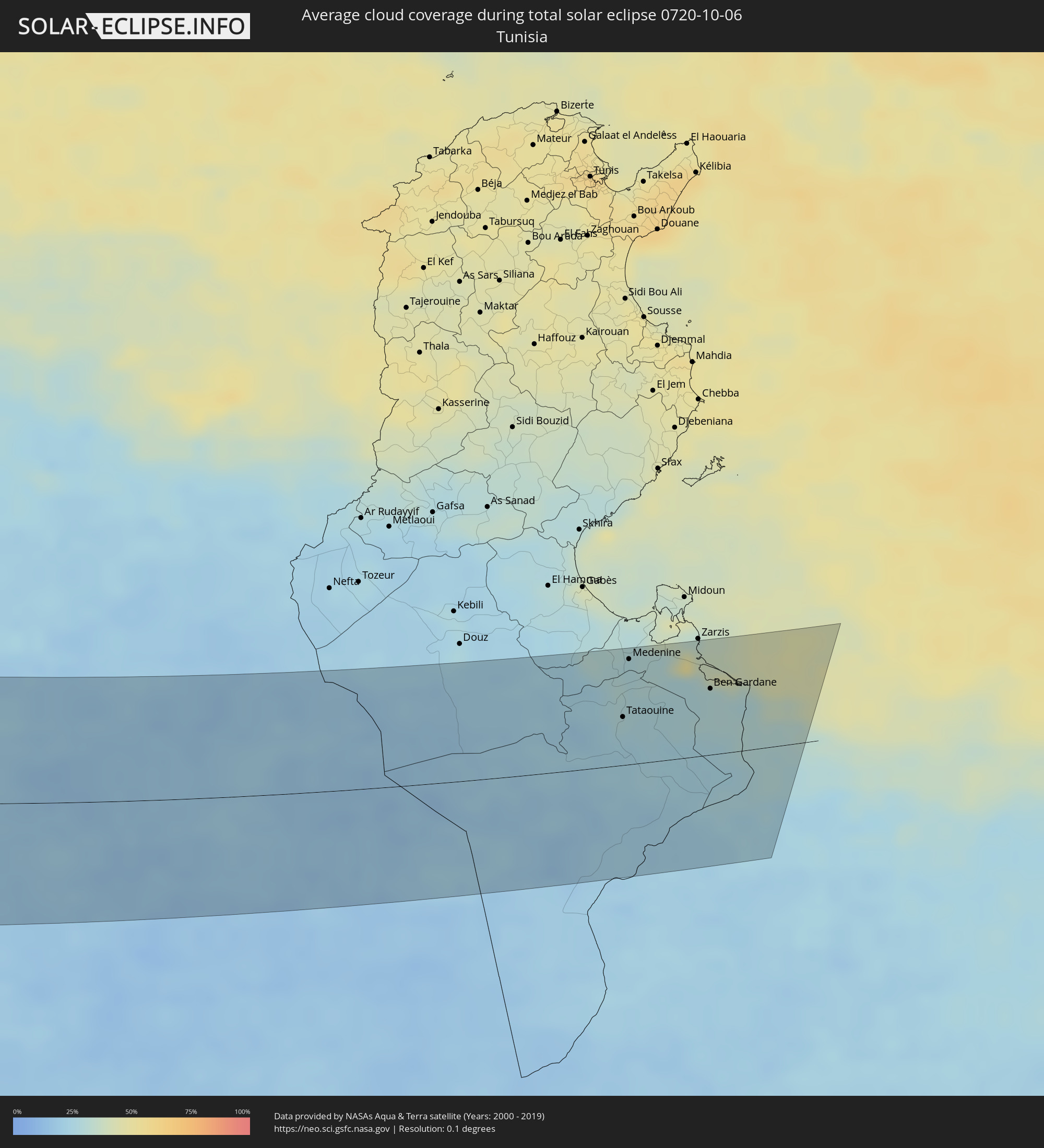 Tunisia
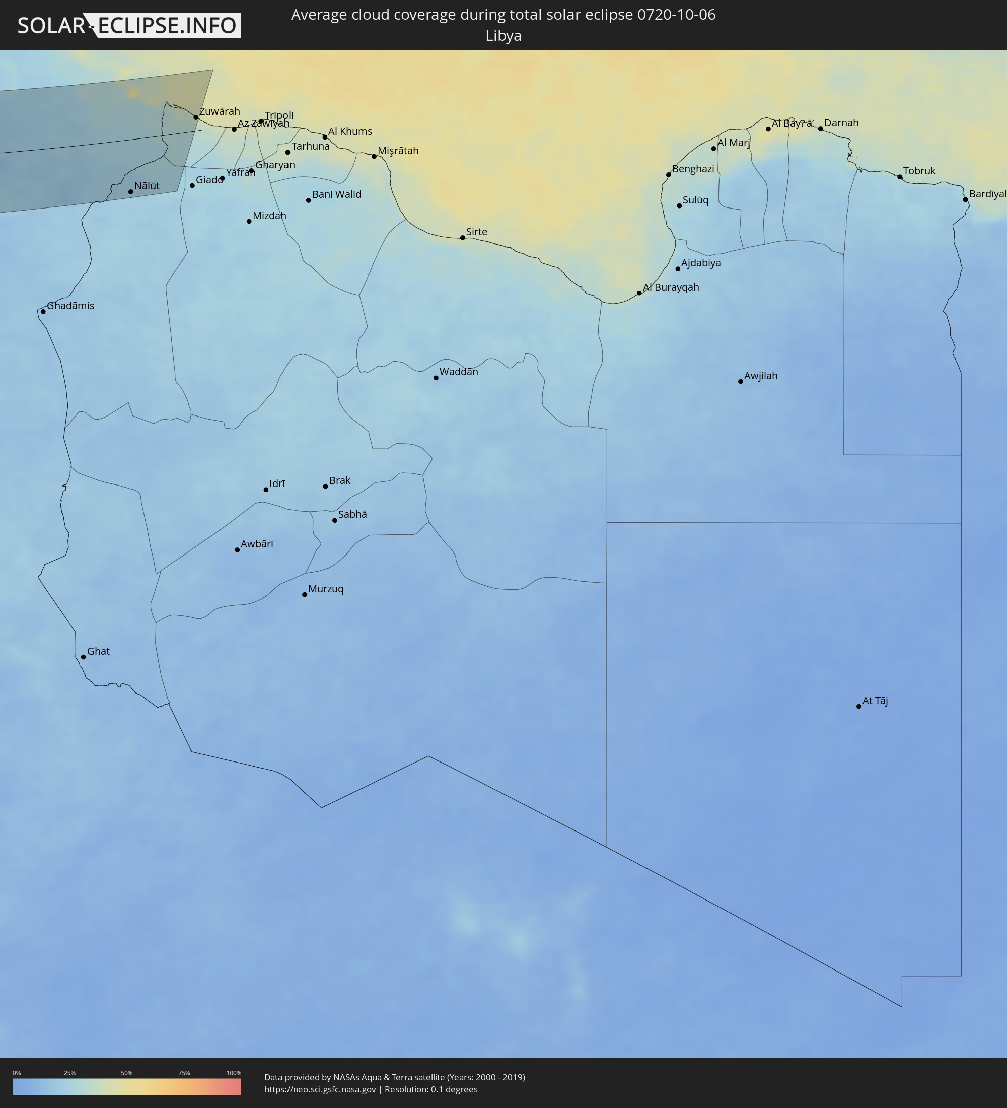 Libya
Libya
Cities inside the path of the eclipse
The following table shows all locations with a population of more than 5,000 inside the eclipse path. Cities which have more than 100,000 inhabitants are marked bold. A click at the locations opens a detailed map.
| City | Type | Eclipse duration | Local time of max. eclipse | Distance to central line | Ø Cloud coverage |
|
El Jadida, Doukkala-Abda
|
total | - | 16:00:05 UTC-00:30 | 101 km | 36% |
|
Azemmour, Doukkala-Abda
|
total | - | 16:00:09 UTC-00:30 | 92 km | 33% |
|
Nouaseur, Chaouia-Ouardigha
|
total | - | 16:00:34 UTC-00:30 | 59 km | 31% |
|
Settat, Chaouia-Ouardigha
|
total | - | 16:01:16 UTC-00:30 | 99 km | 25% |
|
Casablanca, Grand Casablanca
|
total | - | 16:00:12 UTC-00:30 | 37 km | 34% |
|
Berrechid, Chaouia-Ouardigha
|
total | - | 16:00:48 UTC-00:30 | 71 km | 32% |
|
Mohammedia, Grand Casablanca
|
total | - | 16:00:12 UTC-00:30 | 20 km | 33% |
|
Bouznika, Chaouia-Ouardigha
|
total | - | 16:00:11 UTC-00:30 | 2 km | 31% |
|
Skhirate, Rabat-Salé-Zemmour-Zaër
|
total | - | 16:00:10 UTC-00:30 | 8 km | 34% |
|
Khouribga, Chaouia-Ouardigha
|
total | - | 16:02:02 UTC-00:30 | 91 km | 25% |
|
Rabat, Rabat-Salé-Zemmour-Zaër
|
total | - | 16:00:02 UTC-00:30 | 31 km | 34% |
|
Sale, Rabat-Salé-Zemmour-Zaër
|
total | - | 15:59:59 UTC-00:30 | 36 km | 40% |
|
Boujniba, Chaouia-Ouardigha
|
total | - | 16:02:06 UTC-00:30 | 85 km | 25% |
|
Kenitra, Gharb-Chrarda-Beni Hssen
|
total | - | 15:59:47 UTC-00:30 | 64 km | 38% |
|
Oued Zem, Chaouia-Ouardigha
|
total | - | 16:02:19 UTC-00:30 | 84 km | 21% |
|
Tiflet, Rabat-Salé-Zemmour-Zaër
|
total | - | 16:00:39 UTC-00:30 | 33 km | 28% |
|
Sidi Yahia El Gharb, Gharb-Chrarda-Beni Hssen
|
total | - | 15:59:55 UTC-00:30 | 77 km | 37% |
|
Kasba Tadla, Tadla-Azilal
|
total | - | 16:03:02 UTC-00:30 | 104 km | 23% |
|
Khemisset, Rabat-Salé-Zemmour-Zaër
|
total | - | 16:00:58 UTC-00:30 | 32 km | 23% |
|
Mechraa Bel Ksiri, Gharb-Chrarda-Beni Hssen
|
total | - | 15:59:41 UTC-00:30 | 115 km | 34% |
|
Sidi Slimane, Gharb-Chrarda-Beni Hssen
|
total | - | 16:00:16 UTC-00:30 | 83 km | 33% |
|
Sidi Qacem, Gharb-Chrarda-Beni Hssen
|
total | - | 16:00:31 UTC-00:30 | 84 km | 30% |
|
Khenifra, Meknès-Tafilalet
|
total | - | 16:02:53 UTC-00:30 | 52 km | 24% |
|
Meknès, Meknès-Tafilalet
|
total | - | 16:01:14 UTC-00:30 | 53 km | 26% |
|
El Hajeb, Meknès-Tafilalet
|
total | - | 16:01:44 UTC-00:30 | 36 km | 29% |
|
Azrou, Meknès-Tafilalet
|
total | - | 16:02:18 UTC-00:30 | 12 km | 32% |
|
Fes, Fès-Boulemane
|
total | - | 16:01:22 UTC-00:30 | 82 km | 29% |
|
Fès al Bali, Fès-Boulemane
|
total | - | 16:01:20 UTC-00:30 | 87 km | 29% |
|
Sefrou, Fès-Boulemane
|
total | - | 16:01:52 UTC-00:30 | 65 km | 31% |
|
Midelt, Meknès-Tafilalet
|
total | - | 16:03:59 UTC-00:30 | 57 km | 30% |
|
Tahla, Taza-Al Hoceima-Taounate
|
total | - | 16:01:45 UTC-00:30 | 97 km | 27% |
|
Figuig (Centre), Oriental
|
total | - | 16:07:17 UTC-00:30 | 58 km | 26% |
|
Aïn Sefra, Naama
|
total | - | 16:46:13 UTC+00:09 | 21 km | 28% |
|
Naama, Naama
|
total | - | 16:45:27 UTC+00:09 | 81 km | 26% |
|
El Abiodh Sidi Cheikh, El Bayadh
|
total | - | 16:46:35 UTC+00:09 | 49 km | 27% |
|
Brezina, El Bayadh
|
total | - | 16:46:36 UTC+00:09 | 78 km | 25% |
|
Metlili Chaamba, Ghardaia
|
total | - | 16:49:11 UTC+00:09 | 4 km | 21% |
|
Ghardaïa, Ghardaia
|
total | - | 16:48:49 UTC+00:09 | 21 km | 23% |
|
Berriane, Ghardaia
|
total | - | 16:48:17 UTC+00:09 | 59 km | 22% |
|
Ouargla, Ouargla
|
total | - | 16:50:25 UTC+00:09 | 38 km | 19% |
|
Rouissat, Ouargla
|
total | - | 16:50:28 UTC+00:09 | 41 km | 19% |
|
El Hadjira, Ouargla
|
total | - | 16:49:22 UTC+00:09 | 35 km | 15% |
|
Touggourt, Ouargla
|
total | - | 16:48:44 UTC+00:09 | 89 km | 20% |
|
Hassi Messaoud, Ouargla
|
total | - | 16:51:08 UTC+00:09 | 70 km | 16% |
|
Tebesbest, Ouargla
|
total | - | 16:48:43 UTC+00:09 | 90 km | 20% |
|
Megarine, Ouargla
|
total | - | 16:48:36 UTC+00:09 | 98 km | 20% |
|
Tataouine, Tataouine
|
total | - | 16:50:23 UTC+00:09 | 39 km | 25% |
|
Medenine, Madanīn
|
total | - | 16:49:41 UTC+00:09 | 86 km | 27% |
|
Nālūt, Sha‘bīyat Nālūt
|
total | - | 17:35:37 UTC+00:52 | 84 km | 21% |
|
Ben Gardane, Madanīn
|
total | - | 16:50:13 UTC+00:09 | 54 km | 29% |
|
Zalţan, An Nuqāţ al Khams
|
total | - | 17:34:03 UTC+00:52 | 27 km | 30% |
|
Zuwārah, An Nuqāţ al Khams
|
total | - | 17:34:07 UTC+00:52 | 20 km | 32% |