Total solar eclipse of 03/23/0749
| Day of week: | Wednesday |
| Maximum duration of eclipse: | 01m53s |
| Maximum width of eclipse path: | 208 km |
| Saros cycle: | 80 |
| Coverage: | 100% |
| Magnitude: | 1.0275 |
| Gamma: | 0.8932 |
Wo kann man die Sonnenfinsternis vom 03/23/0749 sehen?
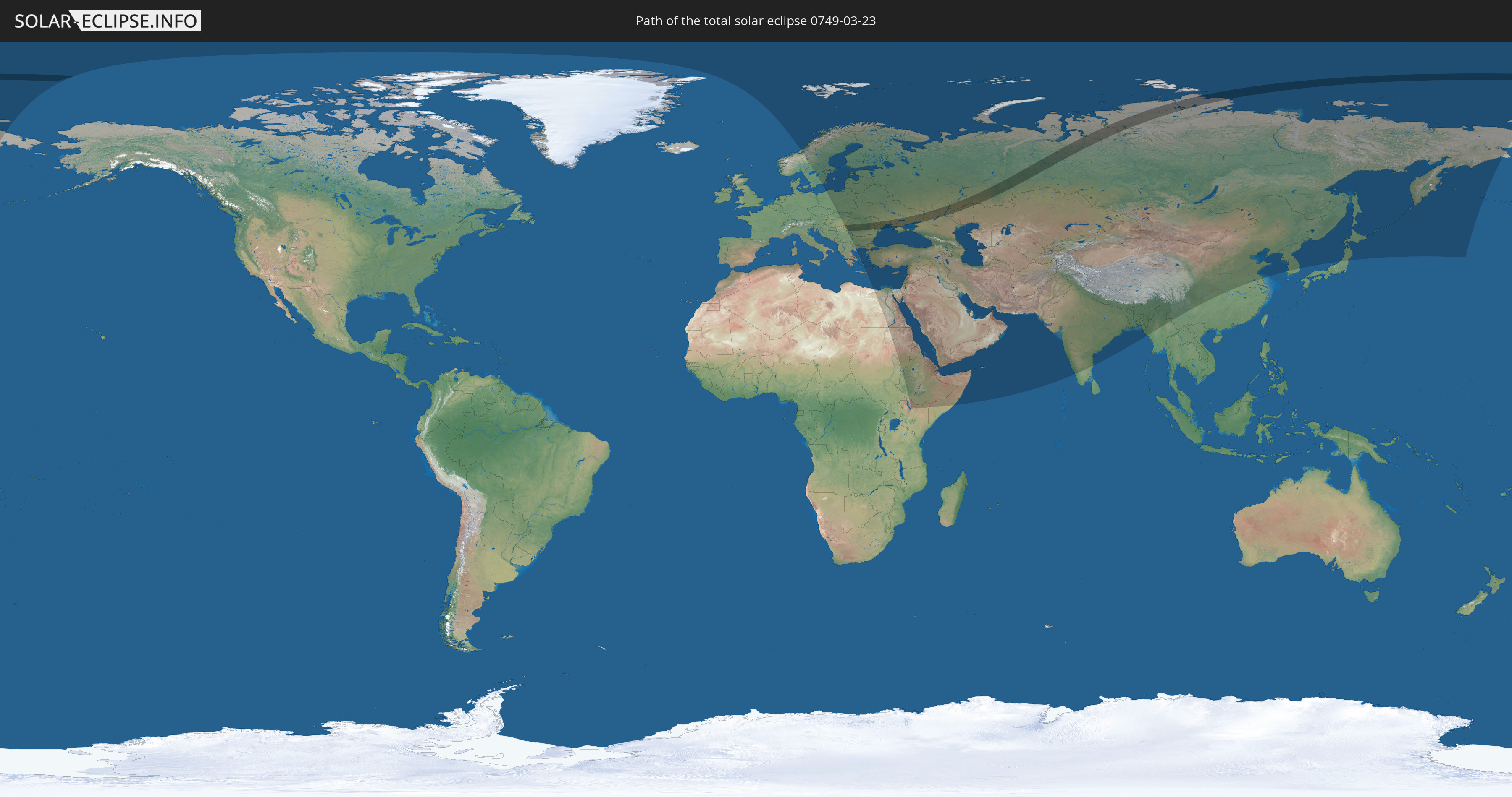
Die Sonnenfinsternis am 03/23/0749 kann man in 63 Ländern als partielle Sonnenfinsternis beobachten.
Der Finsternispfad verläuft durch 6 Länder. Nur in diesen Ländern ist sie als total Sonnenfinsternis zu sehen.
In den folgenden Ländern ist die Sonnenfinsternis total zu sehen
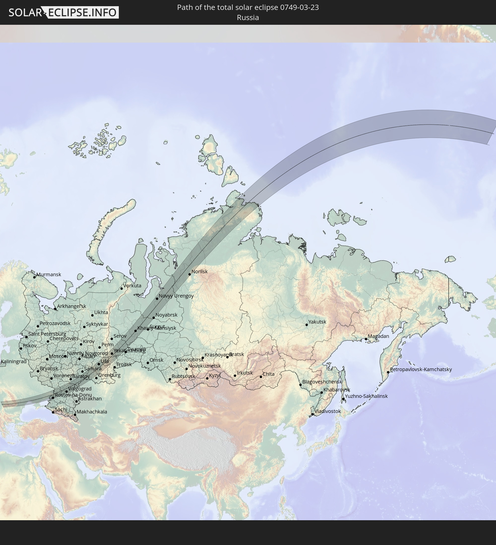 Russia
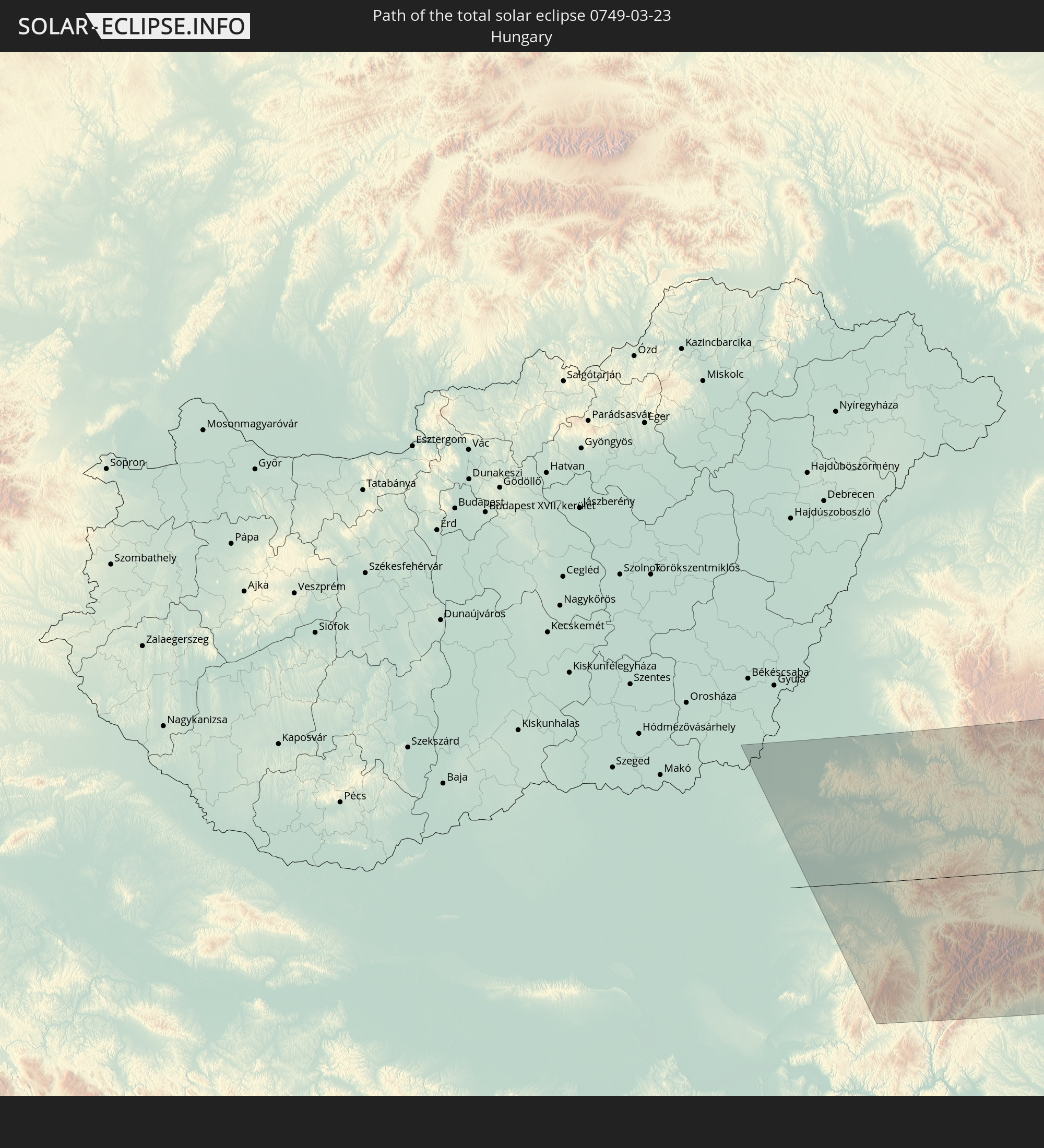 Hungary
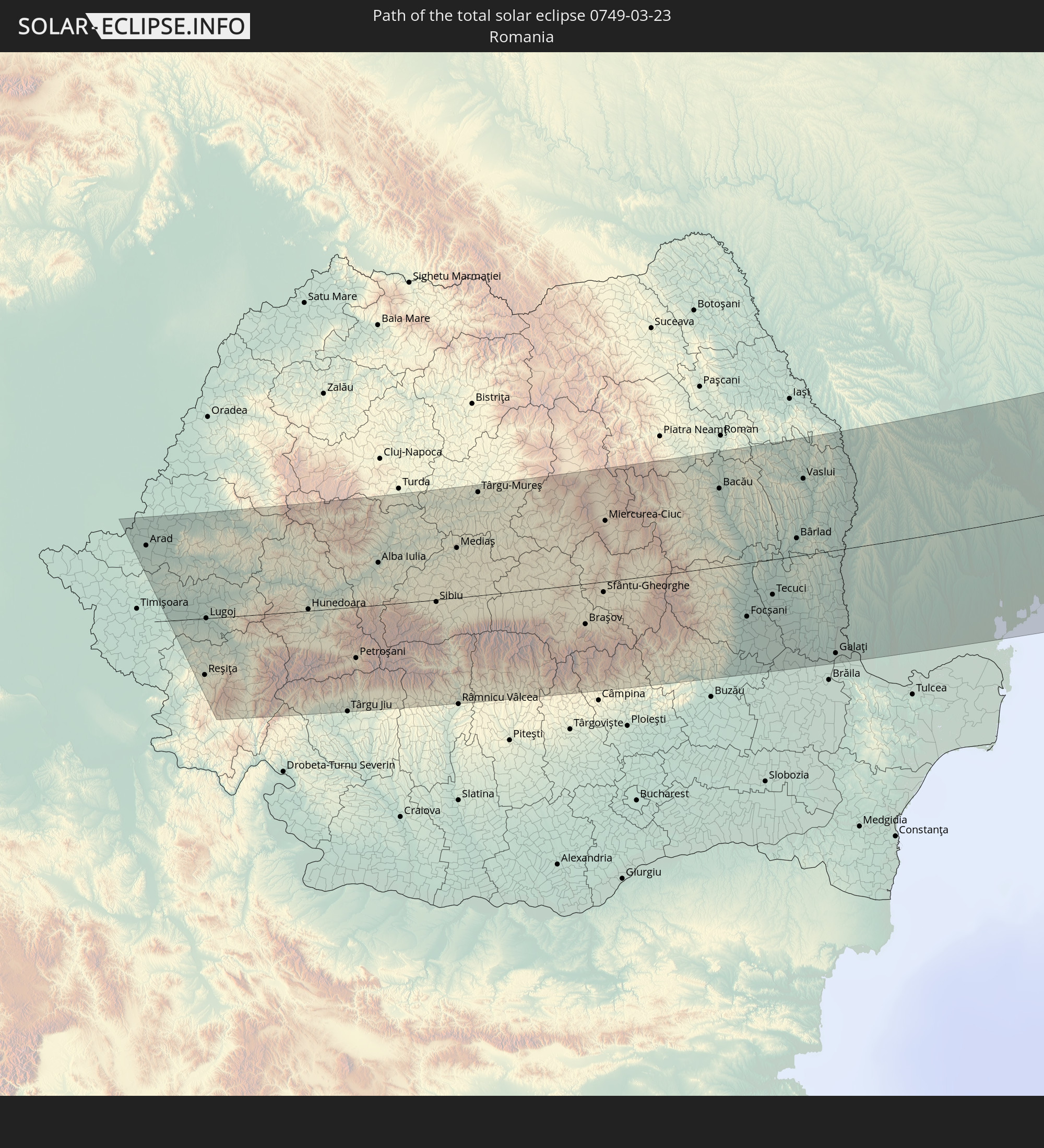 Romania
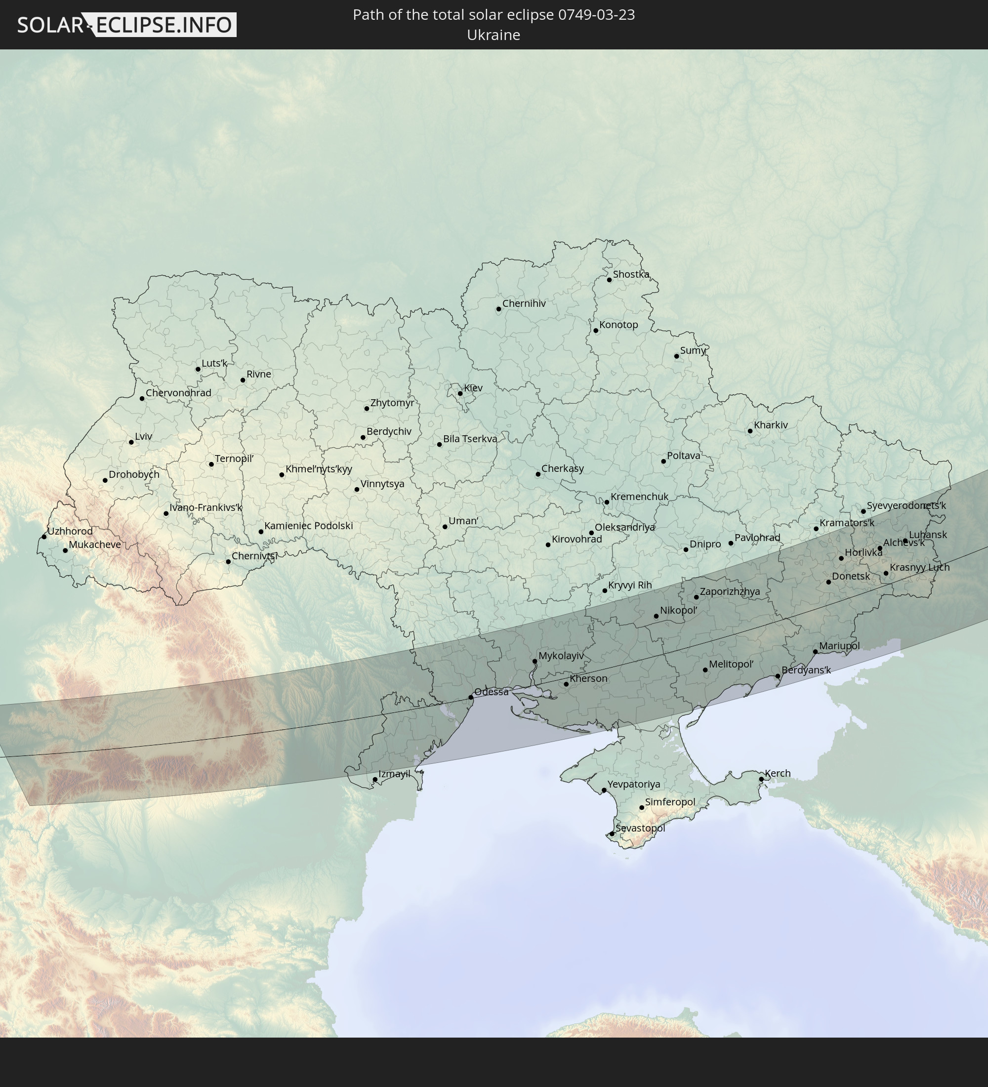 Ukraine
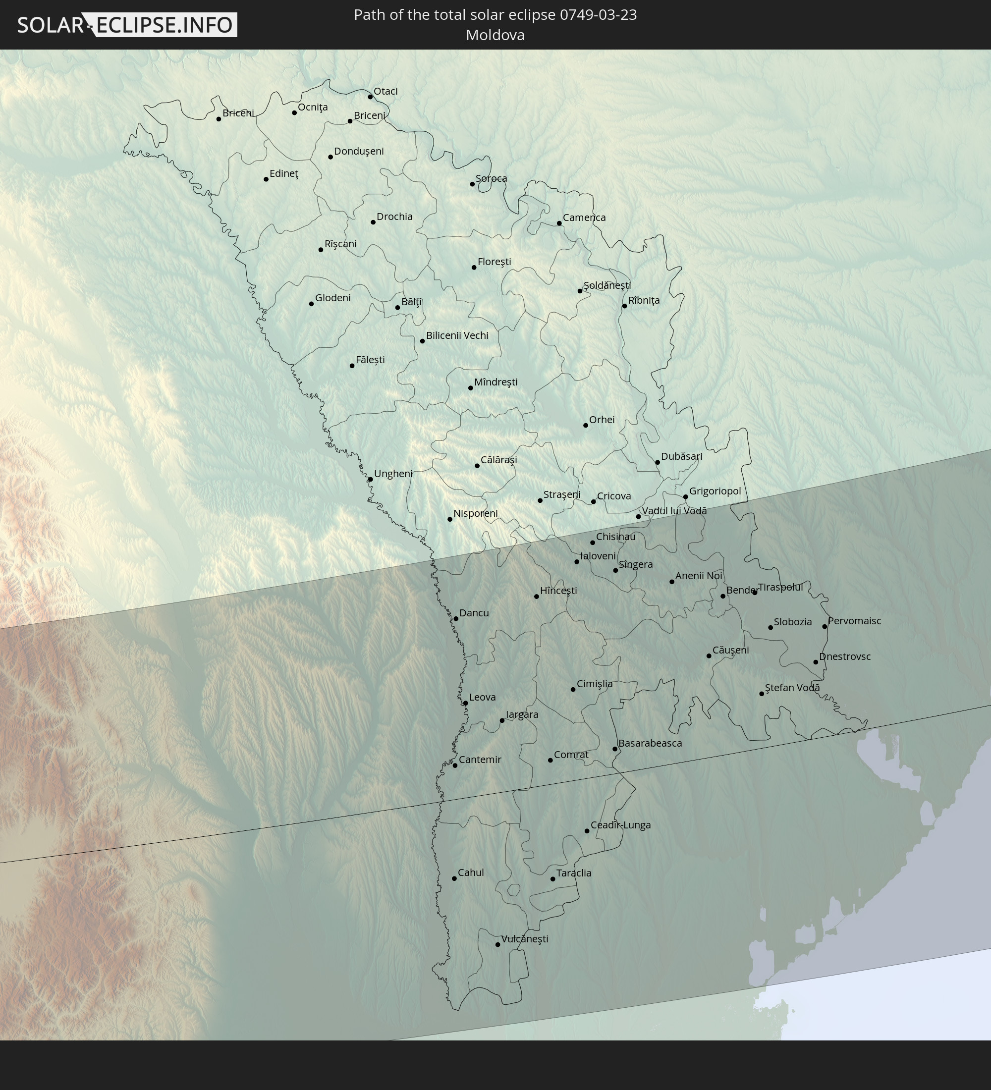 Moldova
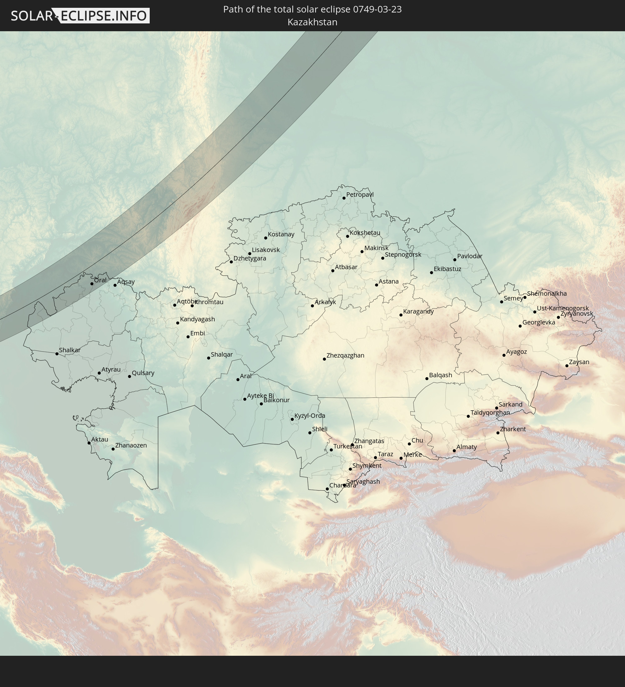 Kazakhstan
In den folgenden Ländern ist die Sonnenfinsternis partiell zu sehen
 Russia
 United States
 Svalbard and Jan Mayen
 Norway
 Sweden
 Poland
 Hungary
 Slovakia
 Serbia
 Åland Islands
 Greece
 Romania
 Finland
 Lithuania
 Latvia
 Estonia
 Sudan
Sudan
 Ukraine
 Bulgaria
 Belarus
 Egypt
Egypt
 Turkey
 Moldova
 Cyprus
 Ethiopia
 Kenya
Kenya
 State of Palestine
 Israel
 Saudi Arabia
 Jordan
 Lebanon
 Syria
Syria
 Eritrea
 Iraq
Iraq
 Georgia
 Somalia
 Djibouti
 Yemen
Yemen
 Armenia
 Iran
Iran
 Azerbaijan
 Kazakhstan
 Kuwait
 Bahrain
 Qatar
Qatar
 United Arab Emirates
 Oman
Oman
 Turkmenistan
 Uzbekistan
 Afghanistan
 Pakistan
 Tajikistan
 India
India
 Kyrgyzstan
 China
China
 Nepal
Nepal
 Mongolia
 Bangladesh
 Bhutan
 Myanmar
 Japan
Japan
 North Korea
 South Korea
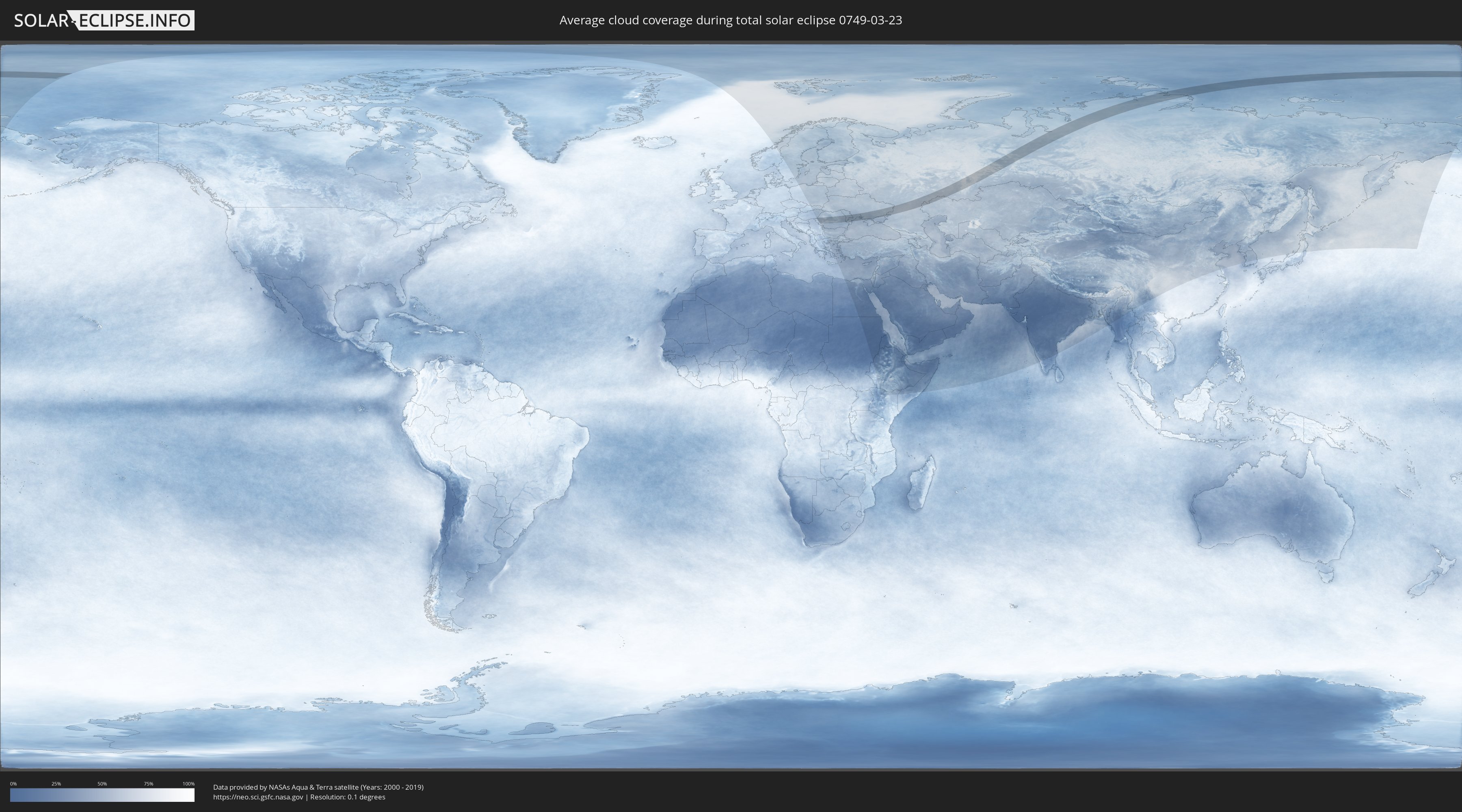
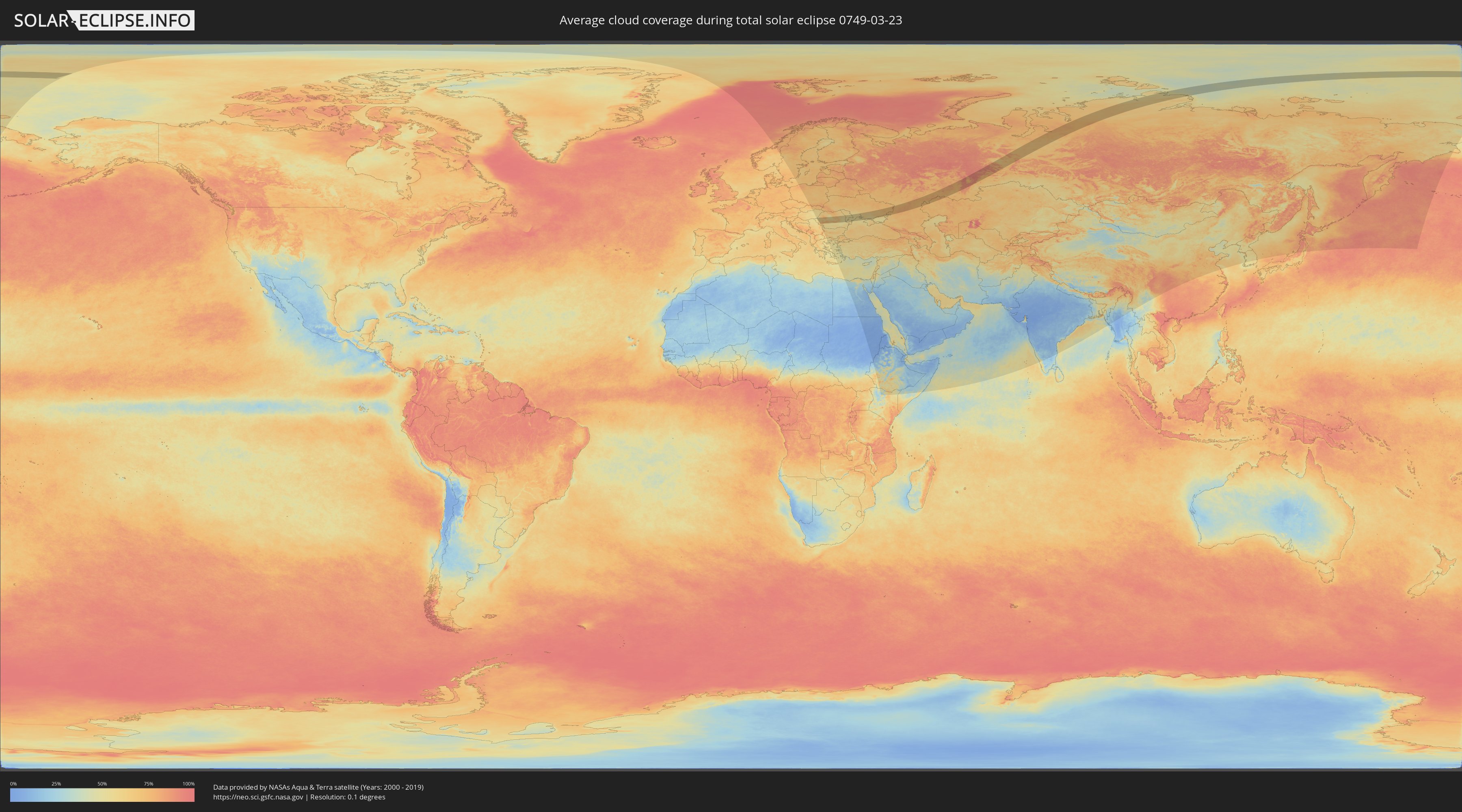
How will be the weather during the total solar eclipse on 03/23/0749?
Where is the best place to see the total solar eclipse of 03/23/0749?
The following maps show the average cloud coverage for the day of the total solar eclipse.
With the help of these maps, it is possible to find the place along the eclipse path, which has the best
chance of a cloudless sky.
Nevertheless, you should consider local circumstances and inform about the weather of your chosen
observation site.
The data is provided by NASAs satellites
AQUA and TERRA.
The cloud maps are averaged over a period of 19 years (2000 - 2019).
Detailed country maps
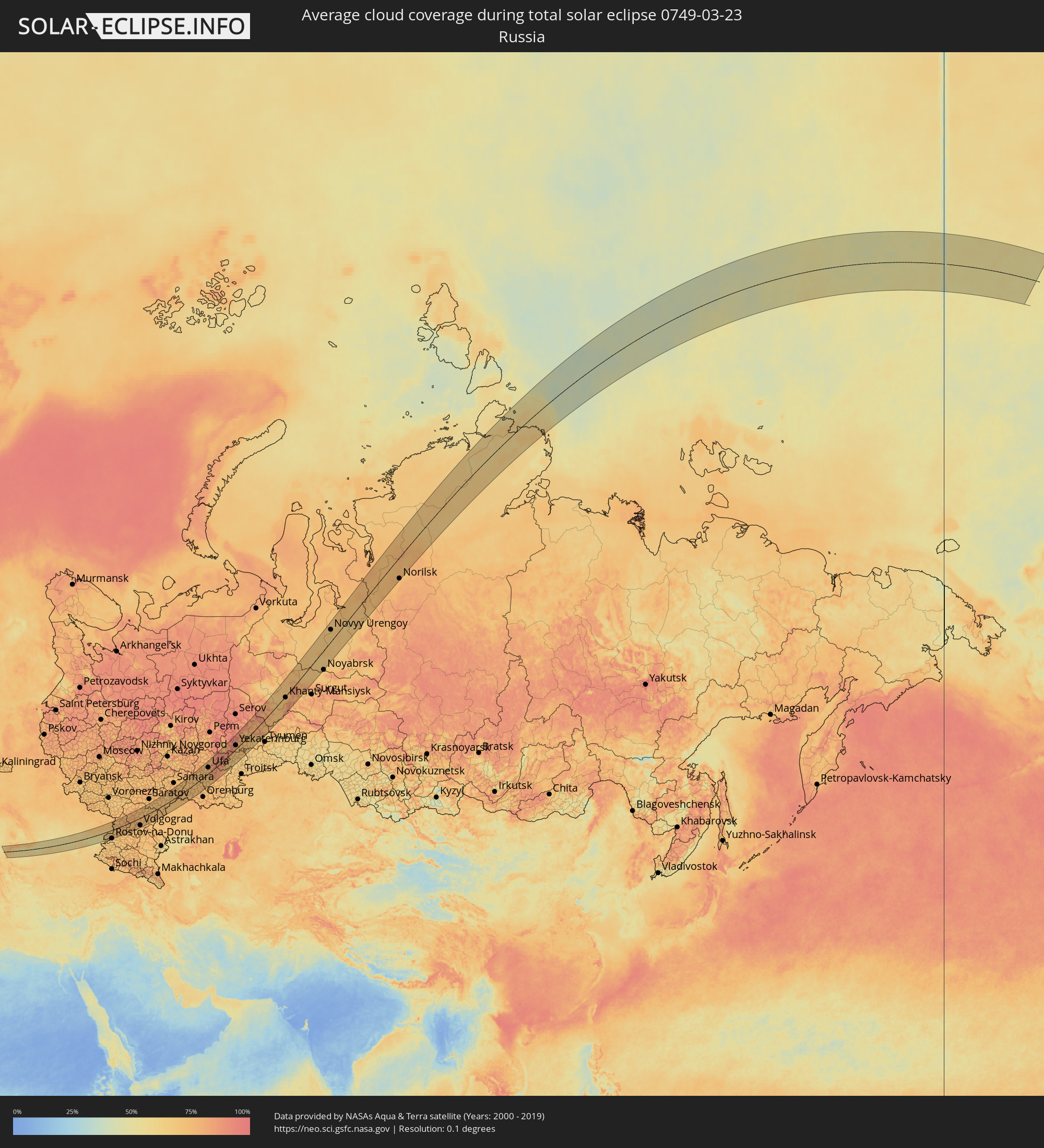 Russia
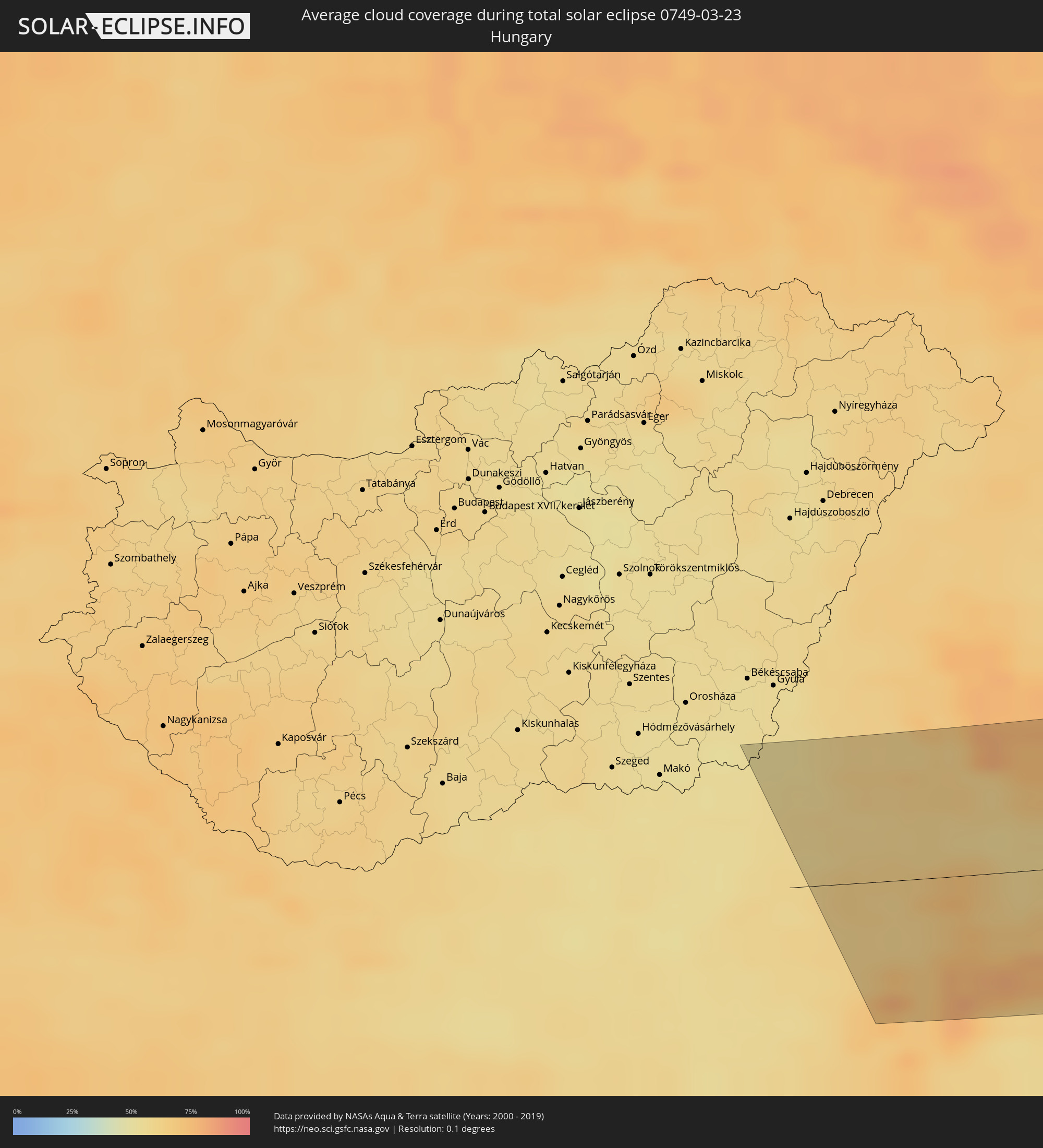 Hungary
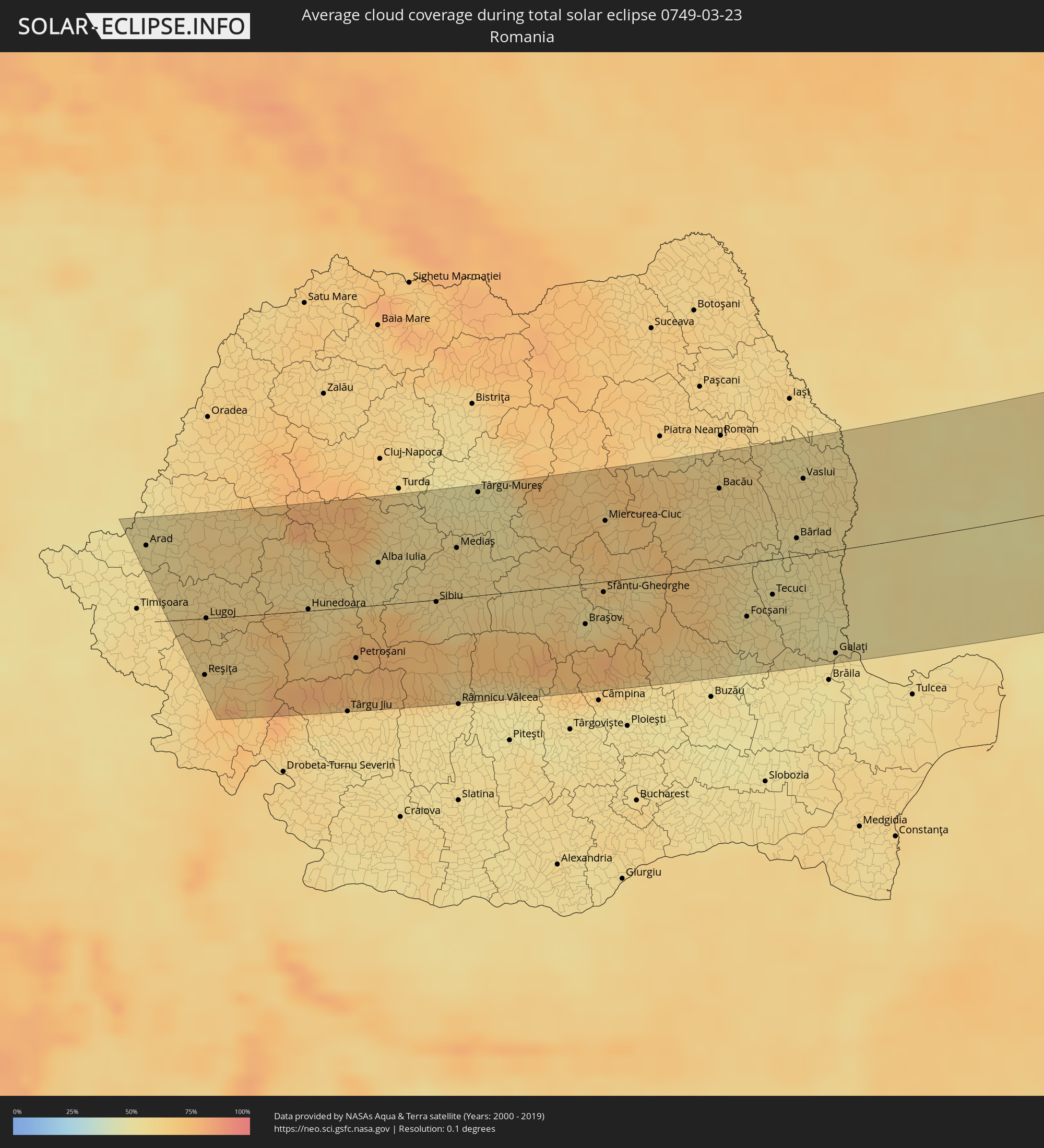 Romania
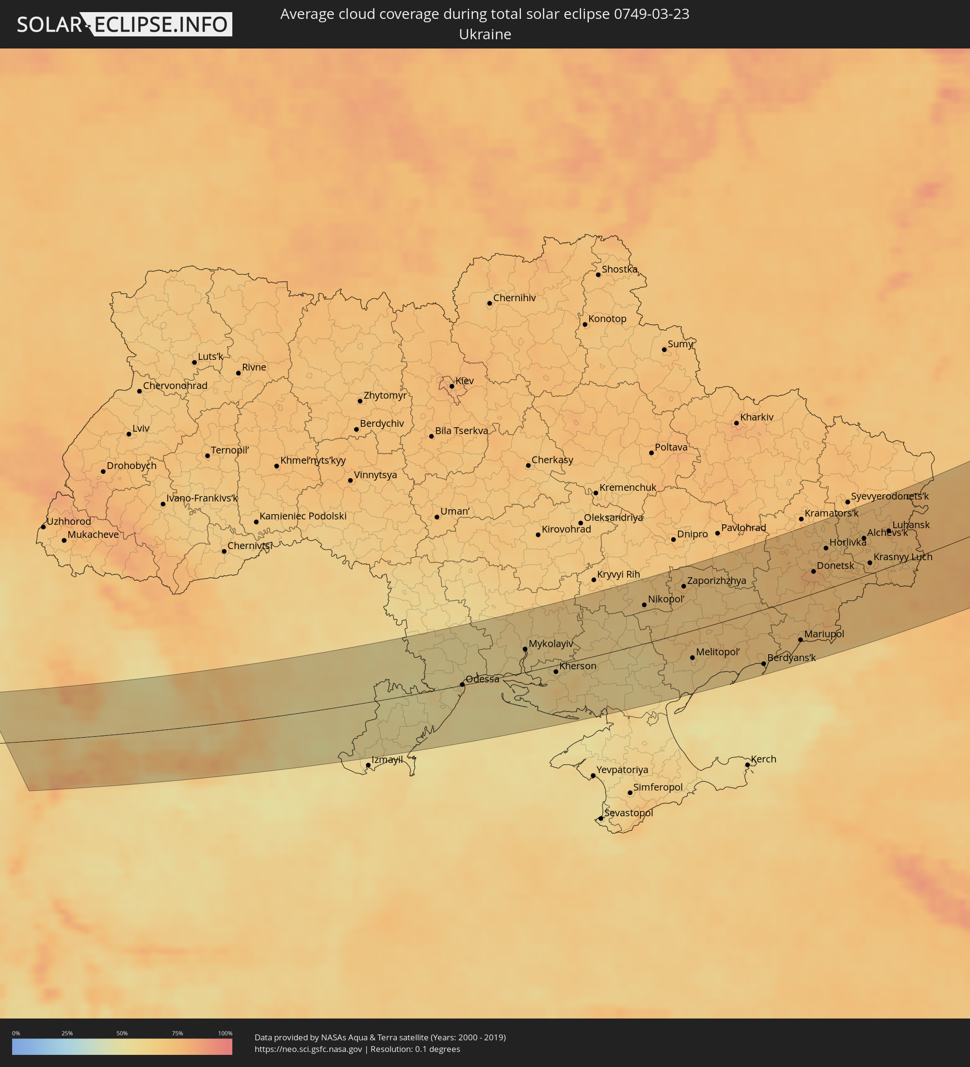 Ukraine
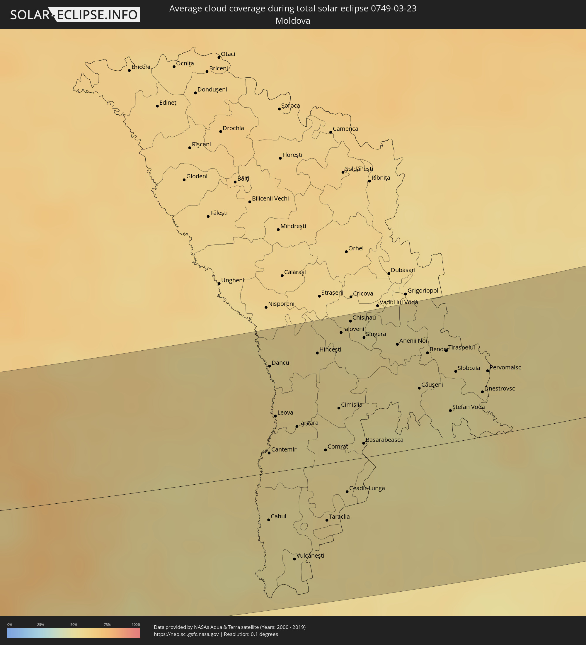 Moldova
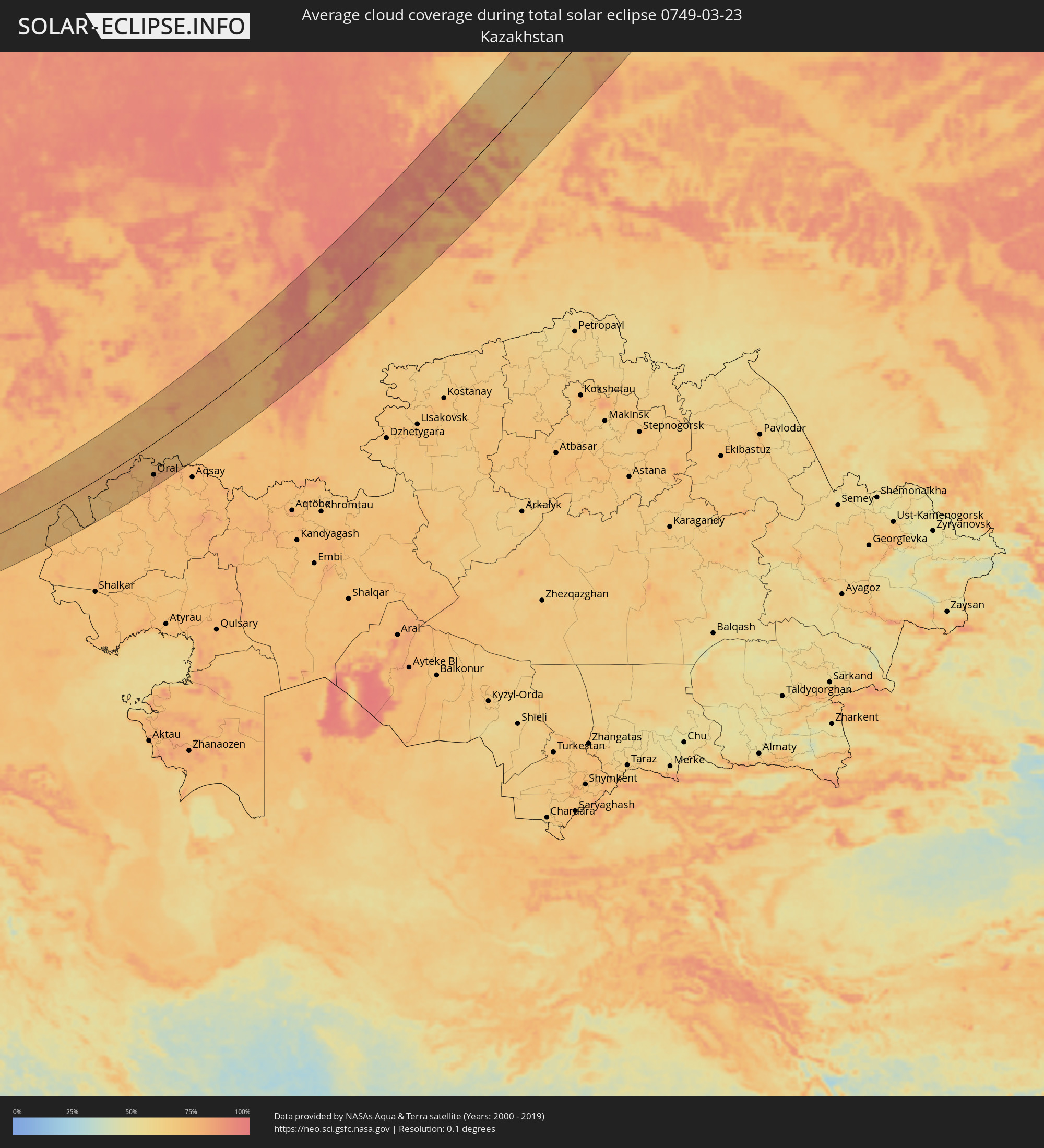 Kazakhstan
Cities inside the path of the eclipse
The following table shows all locations with a population of more than 5,000 inside the eclipse path. Cities which have more than 100,000 inhabitants are marked bold. A click at the locations opens a detailed map.
| City | Type | Eclipse duration | Local time of max. eclipse | Distance to central line | Ø Cloud coverage |
|
Arad, Arad
|
total | - | 06:15:48 UTC+01:44 | 58 km | 55% |
|
Reşiţa, Caraş-Severin
|
total | - | 06:14:19 UTC+01:44 | 45 km | 63% |
|
Lugoj, Timiş
|
total | - | 06:14:57 UTC+01:44 | 8 km | 63% |
|
Caransebeş, Caraş-Severin
|
total | - | 06:14:29 UTC+01:44 | 35 km | 64% |
|
Brad, Hunedoara
|
total | - | 06:15:39 UTC+01:44 | 46 km | 61% |
|
Hunedoara, Hunedoara
|
total | - | 06:15:00 UTC+01:44 | 8 km | 60% |
|
Târgu Jiu, Gorj
|
total | - | 06:13:51 UTC+01:44 | 80 km | 59% |
|
Petroşani, Hunedoara
|
total | - | 06:14:27 UTC+01:44 | 41 km | 74% |
|
Cugir, Alba
|
total | - | 06:15:08 UTC+01:44 | 12 km | 69% |
|
Alba Iulia, Alba
|
total | - | 06:15:31 UTC+01:44 | 33 km | 57% |
|
Aiud, Alba
|
total | - | 06:15:55 UTC+01:44 | 60 km | 58% |
|
Blaj, Alba
|
total | - | 06:15:41 UTC+01:44 | 42 km | 56% |
|
Luduş, Mureş
|
total | - | 06:16:12 UTC+01:44 | 76 km | 54% |
|
Sibiu, Sibiu
|
total | - | 06:15:04 UTC+01:44 | 12 km | 60% |
|
Târnăveni, Mureş
|
total | - | 06:15:57 UTC+01:44 | 57 km | 58% |
|
Mediaş, Sibiu
|
total | - | 06:15:40 UTC+01:44 | 38 km | 57% |
|
Avrig, Sibiu
|
total | - | 06:14:55 UTC+01:44 | 16 km | 65% |
|
Târgu-Mureş, Mureş
|
total | - | 06:16:18 UTC+01:44 | 78 km | 52% |
|
Curtea de Argeş, Argeş
|
total | - | 06:13:57 UTC+01:44 | 80 km | 51% |
|
Sighișoara, Mureş
|
total | - | 06:15:46 UTC+01:44 | 42 km | 56% |
|
Făgăraș, Braşov
|
total | - | 06:15:09 UTC+01:44 | 4 km | 59% |
|
Odorheiu Secuiesc, Harghita
|
total | - | 06:15:54 UTC+01:44 | 46 km | 65% |
|
Zărnești, Braşov
|
total | - | 06:14:40 UTC+01:44 | 42 km | 73% |
|
Braşov, Braşov
|
total | - | 06:14:49 UTC+01:44 | 31 km | 71% |
|
Comarnic, Prahova
|
total | - | 06:14:09 UTC+01:44 | 75 km | 66% |
|
Sfântu-Gheorghe, Covasna
|
total | - | 06:15:11 UTC+01:44 | 19 km | 56% |
|
Miercurea-Ciuc, Harghita
|
total | - | 06:16:00 UTC+01:44 | 47 km | 64% |
|
Târgu Secuiesc, Covasna
|
total | - | 06:15:25 UTC+01:44 | 11 km | 58% |
|
Moineşti, Bacău
|
total | - | 06:16:15 UTC+01:44 | 53 km | 63% |
|
Târgu Ocna, Bacău
|
total | - | 06:15:55 UTC+01:44 | 32 km | 62% |
|
Buhuşi, Bacău
|
total | - | 06:16:40 UTC+01:44 | 78 km | 62% |
|
Bacău, Bacău
|
total | - | 06:16:25 UTC+01:44 | 58 km | 59% |
|
Râmnicu Sărat, Buzău
|
total | - | 06:14:25 UTC+01:44 | 74 km | 51% |
|
Adjud, Vrancea
|
total | - | 06:15:38 UTC+01:44 | 14 km | 55% |
|
Focșani, Vrancea
|
total | - | 06:14:58 UTC+01:44 | 41 km | 57% |
|
Tecuci, Galaţi
|
total | - | 06:15:14 UTC+01:44 | 28 km | 54% |
|
Bârlad, Vaslui
|
total | - | 06:15:54 UTC+01:44 | 20 km | 54% |
|
Vaslui, Vaslui
|
total | - | 06:16:35 UTC+01:44 | 58 km | 57% |
|
Galaţi, Galaţi
|
total | - | 06:14:36 UTC+01:44 | 78 km | 56% |
|
Huşi, Vaslui
|
total | - | 06:16:41 UTC+01:44 | 59 km | 58% |
|
Cahul, Cahul
|
total | - | 06:25:59 UTC+01:55 | 31 km | 54% |
|
Cantemir, Cantemir
|
total | - | 06:26:37 UTC+01:55 | 21 km | 56% |
|
Dancu, Hînceşti
|
total | - | 06:27:27 UTC+01:55 | 66 km | 55% |
|
Leova, Leova
|
total | - | 06:26:58 UTC+01:55 | 37 km | 55% |
|
Vulcăneşti, Găgăuzia
|
total | - | 06:25:37 UTC+01:55 | 58 km | 51% |
|
Iargara, Cantemir
|
total | - | 06:26:53 UTC+01:55 | 26 km | 53% |
|
Hînceşti, Hînceşti
|
total | - | 06:27:36 UTC+01:55 | 70 km | 56% |
|
Comrat, Găgăuzia
|
total | - | 06:26:41 UTC+01:55 | 16 km | 54% |
|
Taraclia, Taraclia
|
total | - | 06:26:01 UTC+01:55 | 36 km | 55% |
|
Cimişlia, Cimişlia
|
total | - | 06:27:06 UTC+01:55 | 35 km | 51% |
|
Ialoveni, Laloveni
|
total | - | 06:27:49 UTC+01:55 | 78 km | 54% |
|
Ceadîr-Lunga, Găgăuzia
|
total | - | 06:26:18 UTC+01:55 | 25 km | 54% |
|
Chisinau, Chişinău
|
total | - | 06:27:56 UTC+01:55 | 84 km | 53% |
|
Basarabeasca, Basarabeasca
|
total | - | 06:26:47 UTC+01:55 | 9 km | 53% |
|
Sîngera, Chişinău
|
total | - | 06:27:47 UTC+01:55 | 73 km | 54% |
|
Anenii Noi, Anenii Noi
|
total | - | 06:27:45 UTC+01:55 | 66 km | 55% |
|
Căuşeni, Căuşeni
|
total | - | 06:27:21 UTC+01:55 | 36 km | 54% |
|
Bender, Bender
|
total | - | 06:27:42 UTC+01:55 | 57 km | 54% |
|
Chiţcani, Căuşeni
|
total | - | 06:27:38 UTC+01:55 | 53 km | 52% |
|
Tiraspolul, Stînga Nistrului
|
total | - | 06:27:44 UTC+01:55 | 59 km | 52% |
|
Ştefan Vodă, Ştefan-Vodă
|
total | - | 06:27:10 UTC+01:55 | 25 km | 50% |
|
Slobozia, Stînga Nistrului
|
total | - | 06:27:33 UTC+01:55 | 45 km | 52% |
|
Dnestrovsc, Teleneşti
|
total | - | 06:27:23 UTC+01:55 | 27 km | 53% |
|
Pervomaisc, Stînga Nistrului
|
total | - | 06:27:35 UTC+01:55 | 39 km | 54% |
|
Bilhorod-Dnistrovs’kyy, Odessa
|
total | - | 06:33:46 UTC+02:02 | 30 km | 54% |
|
Illichivs’k, Odessa
|
total | - | 06:34:00 UTC+02:02 | 20 km | 53% |
|
Odessa, Odessa
|
total | - | 06:34:19 UTC+02:02 | 18 km | 59% |
|
Yuzhne, Odessa
|
total | - | 06:34:37 UTC+02:02 | 15 km | 56% |
|
Mykolayiv, Mykolaiv
|
total | - | 06:35:22 UTC+02:02 | 34 km | 60% |
|
Kherson, Kherson
|
total | - | 06:34:56 UTC+02:02 | 12 km | 60% |
|
Nova Kakhovka, Kherson
|
total | - | 06:35:15 UTC+02:02 | 19 km | 59% |
|
Armyansk, Republic of Crimea
|
total | - | 06:48:07 UTC+02:16 | 89 km | 57% |
|
Nikopol’, Dnipropetrovsk
|
total | - | 06:36:56 UTC+02:02 | 56 km | 64% |
|
Marhanets’, Dnipropetrovsk
|
total | - | 06:37:06 UTC+02:02 | 60 km | 64% |
|
Energodar, Zaporizhia
|
total | - | 06:36:52 UTC+02:02 | 46 km | 63% |
|
Zaporizhzhya, Zaporizhia
|
total | - | 06:37:34 UTC+02:02 | 67 km | 68% |
|
Melitopol’, Zaporizhia
|
total | - | 06:35:53 UTC+02:02 | 44 km | 62% |
|
Tokmak, Zaporizhia
|
total | - | 06:36:41 UTC+02:02 | 16 km | 66% |
|
Polohy, Zaporizhia
|
total | - | 06:37:15 UTC+02:02 | 8 km | 68% |
|
Berdyans’k, Zaporizhia
|
total | - | 06:36:07 UTC+02:02 | 80 km | 64% |
|
Dobropillya, Donetsk
|
total | - | 06:39:15 UTC+02:02 | 94 km | 74% |
|
Krasnoarmiys’k, Donetsk
|
total | - | 06:38:57 UTC+02:02 | 73 km | 74% |
|
Selydove, Donetsk
|
total | - | 06:38:45 UTC+02:02 | 55 km | 72% |
|
Volnovakha, Donetsk
|
total | - | 06:37:49 UTC+02:02 | 7 km | 67% |
|
Mariupol, Donetsk
|
total | - | 06:36:55 UTC+02:02 | 62 km | 67% |
|
Dokuchayevs’k, Donetsk
|
total | - | 06:38:09 UTC+02:02 | 5 km | 70% |
|
Kostyantynivka, Donetsk
|
total | - | 06:39:34 UTC+02:02 | 86 km | 73% |
|
Donetsk, Donetsk
|
total | - | 06:38:41 UTC+02:02 | 31 km | 77% |
|
Dzerzhyns’k, Donetsk
|
total | - | 06:39:22 UTC+02:02 | 69 km | 72% |
|
Artemivs’k, Donetsk
|
total | - | 06:39:47 UTC+02:02 | 86 km | 70% |
|
Horlivka, Donetsk
|
total | - | 06:39:20 UTC+02:02 | 57 km | 72% |
|
Khartsyz’k, Donetsk
|
total | - | 06:38:49 UTC+02:02 | 24 km | 72% |
|
Yenakiyeve, Donetsk
|
total | - | 06:39:11 UTC+02:02 | 43 km | 70% |
|
Popasna, Luhansk
|
total | - | 06:39:58 UTC+02:02 | 81 km | 68% |
|
Debal’tseve, Donetsk
|
total | - | 06:39:27 UTC+02:02 | 49 km | 73% |
|
Shakhtars’k, Donetsk
|
total | - | 06:38:57 UTC+02:02 | 19 km | 72% |
|
Stakhanov, Luhansk
|
total | - | 06:39:57 UTC+02:02 | 67 km | 72% |
|
Snizhne, Donetsk
|
total | - | 06:39:00 UTC+02:02 | 7 km | 69% |
|
Alchevs’k, Luhansk
|
total | - | 06:39:49 UTC+02:02 | 53 km | 74% |
|
Taganrog, Rostov Oblast
|
total | - | 07:05:50 UTC+02:30 | 79 km | 64% |
|
Krasnyy Luch, Luhansk
|
total | - | 06:39:16 UTC+02:02 | 15 km | 71% |
|
Luhansk, Luhansk
|
total | - | 06:40:11 UTC+02:02 | 50 km | 75% |
|
Roven’ky, Luhansk
|
total | - | 06:39:19 UTC+02:02 | 2 km | 72% |
|
Sverdlovs’k, Luhansk
|
total | - | 06:39:26 UTC+02:02 | 8 km | 73% |
|
Krasnodon, Luhansk
|
total | - | 06:39:50 UTC+02:02 | 11 km | 71% |
|
Novoshakhtinsk, Rostov Oblast
|
total | - | 07:07:09 UTC+02:30 | 50 km | 74% |
|
Gukovo, Rostov Oblast
|
total | - | 07:07:42 UTC+02:30 | 19 km | 73% |
|
Donetsk, Rostov Oblast
|
total | - | 07:08:12 UTC+02:30 | 10 km | 73% |
|
Krasnyy Sulin, Rostov Oblast
|
total | - | 07:07:26 UTC+02:30 | 40 km | 74% |
|
Novocherkassk, Rostov Oblast
|
total | - | 07:06:35 UTC+02:30 | 90 km | 72% |
|
Shakhty, Rostov Oblast
|
total | - | 07:07:10 UTC+02:30 | 63 km | 76% |
|
Kamensk-Shakhtinskiy, Rostov Oblast
|
total | - | 07:08:17 UTC+02:30 | 1 km | 75% |
|
Belaya Kalitva, Rostov Oblast
|
total | - | 07:08:15 UTC+02:30 | 28 km | 76% |
|
Mikhaylovka, Volgograd
|
total | - | 07:12:44 UTC+02:30 | 92 km | 73% |
|
Frolovo, Volgograd
|
total | - | 07:12:24 UTC+02:30 | 50 km | 76% |
|
Volgograd, Volgograd
|
total | - | 07:10:51 UTC+02:30 | 82 km | 74% |
|
Volzhskiy, Volgograd
|
total | - | 07:11:07 UTC+02:30 | 84 km | 73% |
|
Kamyshin, Volgograd
|
total | - | 07:13:51 UTC+02:30 | 26 km | 76% |
|
Zhänibek, Batys Qazaqstan
|
total | - | 08:08:28 UTC+03:25 | 90 km | 74% |
|
Pugachev, Saratov
|
total | - | 08:09:18 UTC+03:20 | 92 km | 74% |
|
Kamenka, Batys Qazaqstan
|
total | - | 08:13:36 UTC+03:25 | 49 km | 74% |
|
Oral, Batys Qazaqstan
|
total | - | 08:14:31 UTC+03:25 | 78 km | 81% |
|
Fedorovka, Batys Qazaqstan
|
total | - | 08:14:53 UTC+03:25 | 101 km | 74% |
|
Buzuluk, Orenburg
|
total | - | 08:55:05 UTC+04:02 | 30 km | 81% |
|
Buguruslan, Orenburg
|
total | - | 08:56:48 UTC+04:02 | 101 km | 80% |
|
Belebey, Bashkortostan
|
total | - | 08:58:46 UTC+04:02 | 75 km | 80% |
|
Salavat, Bashkortostan
|
total | - | 08:58:44 UTC+04:02 | 66 km | 75% |
|
Meleuz, Bashkortostan
|
total | - | 08:58:00 UTC+04:02 | 102 km | 74% |
|
Sterlitamak, Bashkortostan
|
total | - | 08:59:12 UTC+04:02 | 45 km | 75% |
|
Ufa, Bashkortostan
|
total | - | 09:01:13 UTC+04:02 | 51 km | 81% |
|
Satka, Chelyabinsk
|
total | - | 09:04:04 UTC+04:02 | 53 km | 91% |
|
Zlatoust, Chelyabinsk
|
total | - | 09:04:47 UTC+04:02 | 68 km | 87% |
|
Pervoural’sk, Sverdlovsk
|
total | - | 09:07:59 UTC+04:02 | 62 km | 89% |
|
Novoural’sk, Sverdlovsk
|
total | - | 09:08:40 UTC+04:02 | 81 km | 90% |
|
Miass, Chelyabinsk
|
total | - | 09:04:56 UTC+04:02 | 98 km | 83% |
|
Polevskoy, Sverdlovsk
|
total | - | 09:07:23 UTC+04:02 | 19 km | 92% |
|
Yekaterinburg, Sverdlovsk
|
total | - | 09:08:25 UTC+04:02 | 28 km | 92% |
|
Ozersk, Chelyabinsk
|
total | - | 09:06:38 UTC+04:02 | 64 km | 83% |
|
Snezhinsk, Chelyabinsk
|
total | - | 09:07:13 UTC+04:02 | 42 km | 88% |
|
Asbest, Sverdlovsk
|
total | - | 09:09:21 UTC+04:02 | 5 km | 89% |
|
Alapayevsk, Sverdlovsk
|
total | - | 09:10:57 UTC+04:02 | 61 km | 87% |
|
Kamensk-Ural’skiy, Sverdlovsk
|
total | - | 09:08:45 UTC+04:02 | 66 km | 76% |
|
Lesnoy, Sverdlovsk
|
total | - | 09:11:41 UTC+04:02 | 19 km | 75% |
|
Uray, Khanty-Mansiyskiy Avtonomnyy Okrug
|
total | - | 09:17:04 UTC+04:02 | 102 km | 75% |
|
Khanty-Mansiysk, Khanty-Mansiyskiy Avtonomnyy Okrug
|
total | - | 09:21:49 UTC+04:02 | 13 km | 70% |
|
Novyy Urengoy, Yamalo-Nenetskiy Avtonomnyy Okrug
|
total | - | 09:34:21 UTC+04:02 | 58 km | 74% |
|
Norilsk, Krasnoyarskiy
|
total | - | 11:54:33 UTC+06:11 | 89 km | 80% |
|
Talnakh, Krasnoyarskiy
|
total | - | 11:54:45 UTC+06:11 | 86 km | 79% |