Total solar eclipse of 03/23/0768
| Day of week: | Saturday |
| Maximum duration of eclipse: | 05m56s |
| Maximum width of eclipse path: | 226 km |
| Saros cycle: | 90 |
| Coverage: | 100% |
| Magnitude: | 1.0679 |
| Gamma: | 0.205 |
Wo kann man die Sonnenfinsternis vom 03/23/0768 sehen?
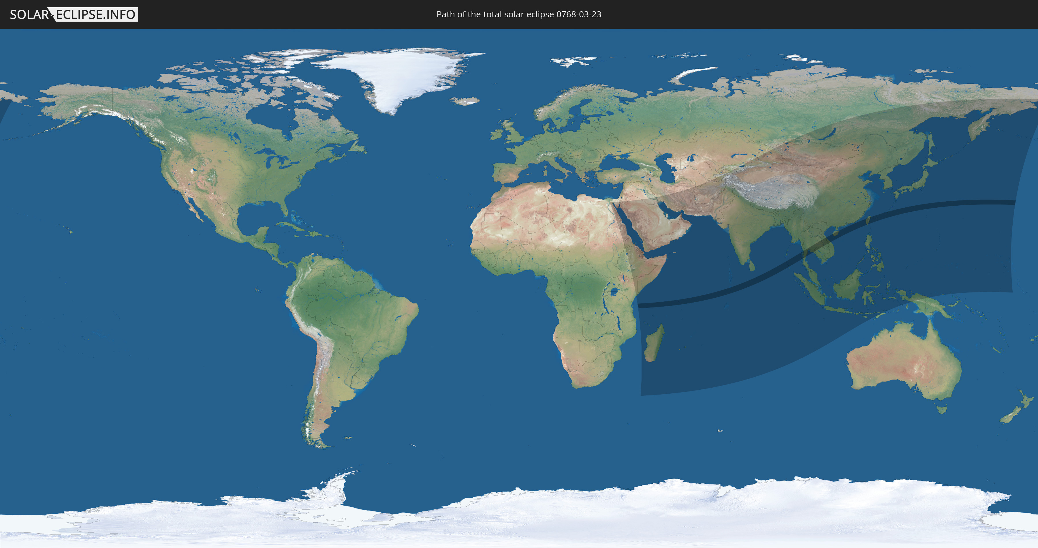
Die Sonnenfinsternis am 03/23/0768 kann man in 71 Ländern als partielle Sonnenfinsternis beobachten.
Der Finsternispfad verläuft durch 11 Länder. Nur in diesen Ländern ist sie als total Sonnenfinsternis zu sehen.
In den folgenden Ländern ist die Sonnenfinsternis total zu sehen
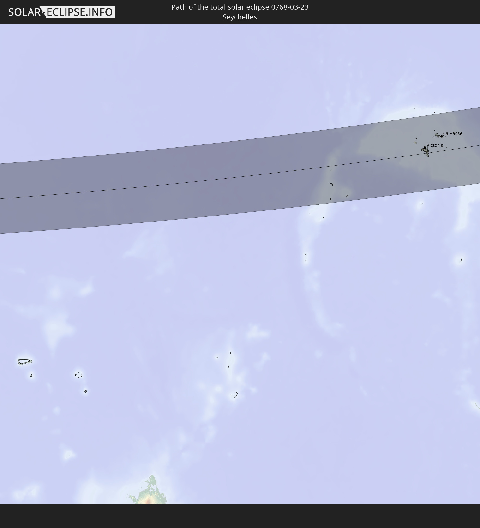 Seychelles
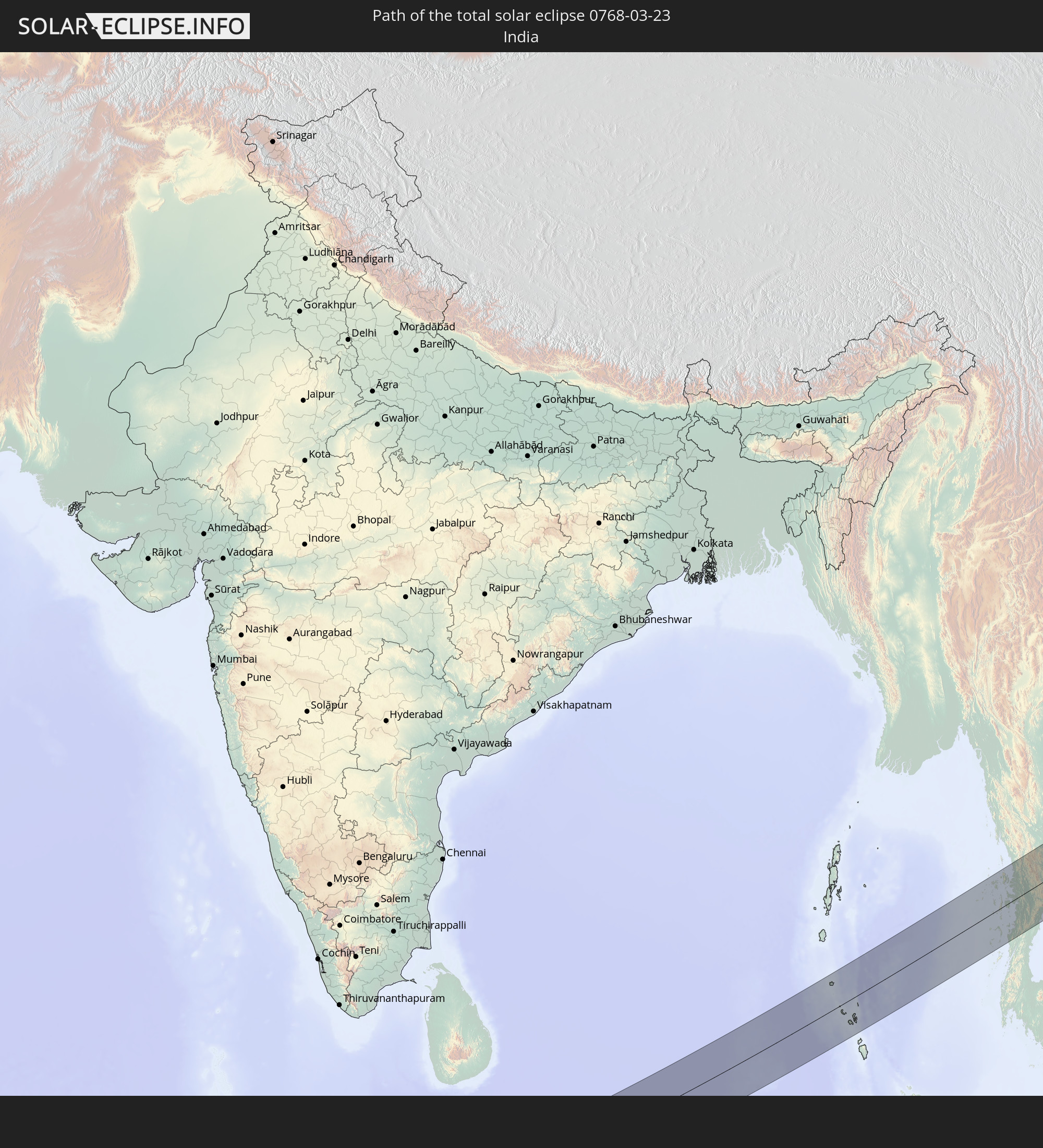 India
India
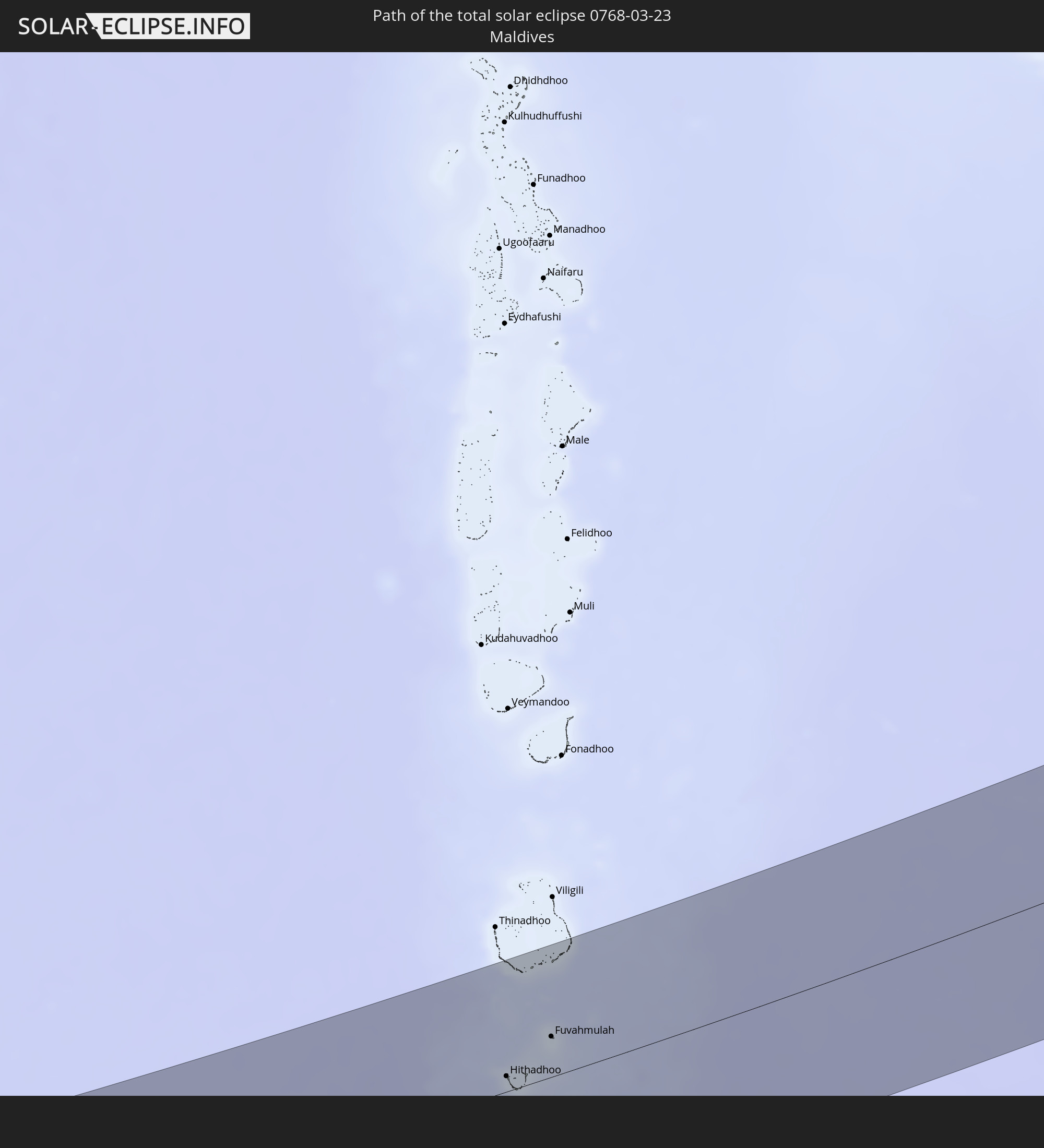 Maldives
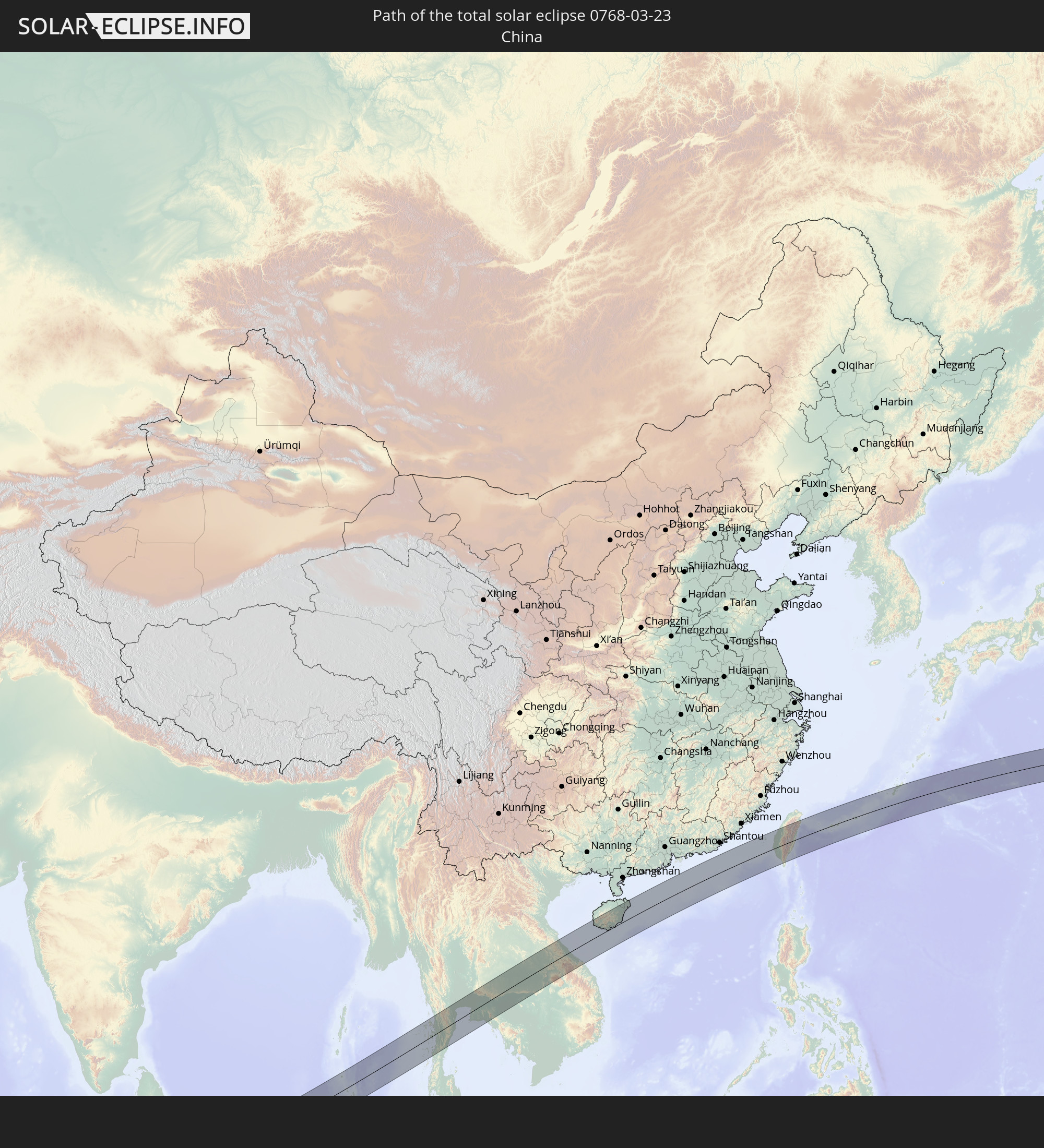 China
China
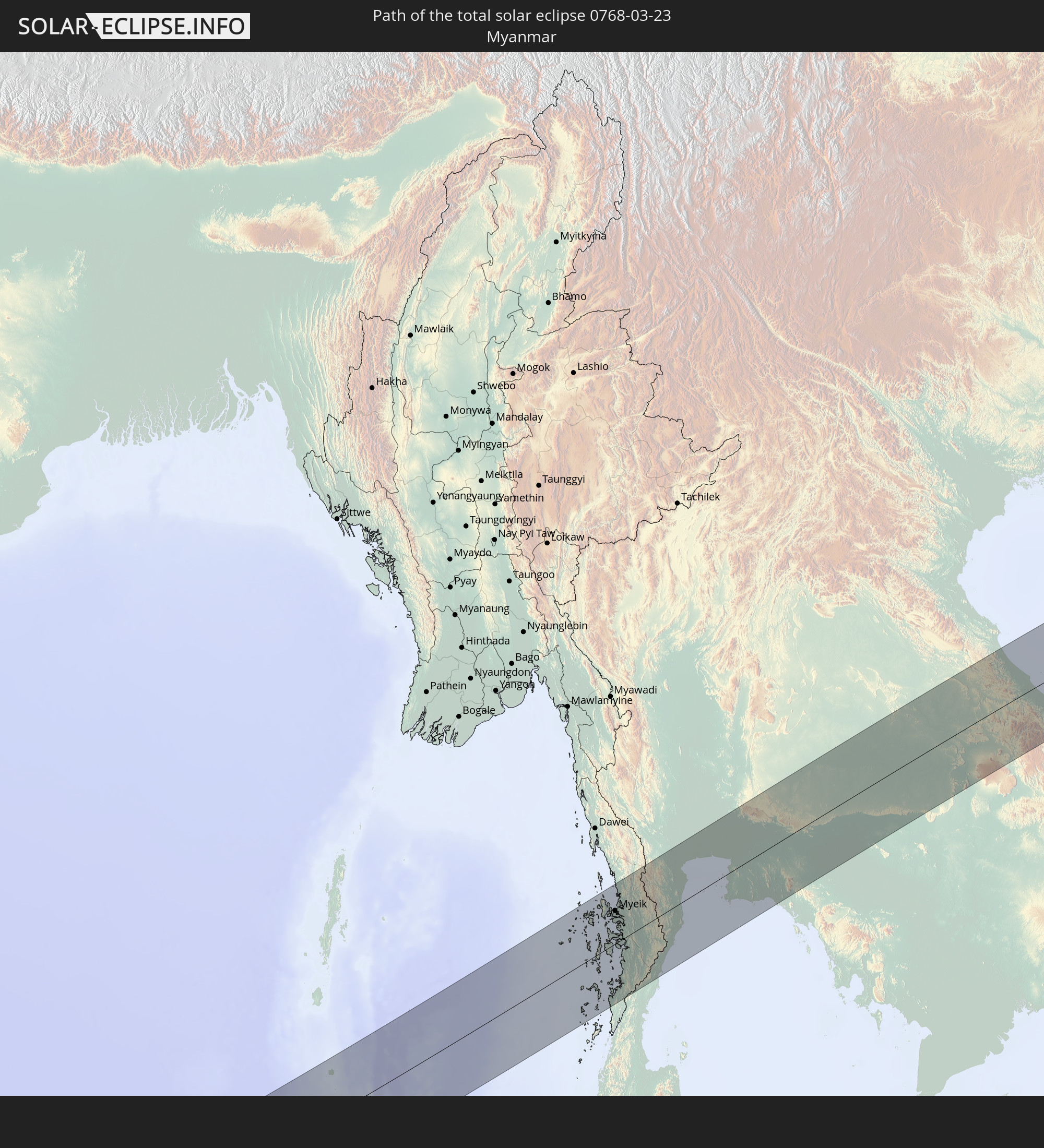 Myanmar
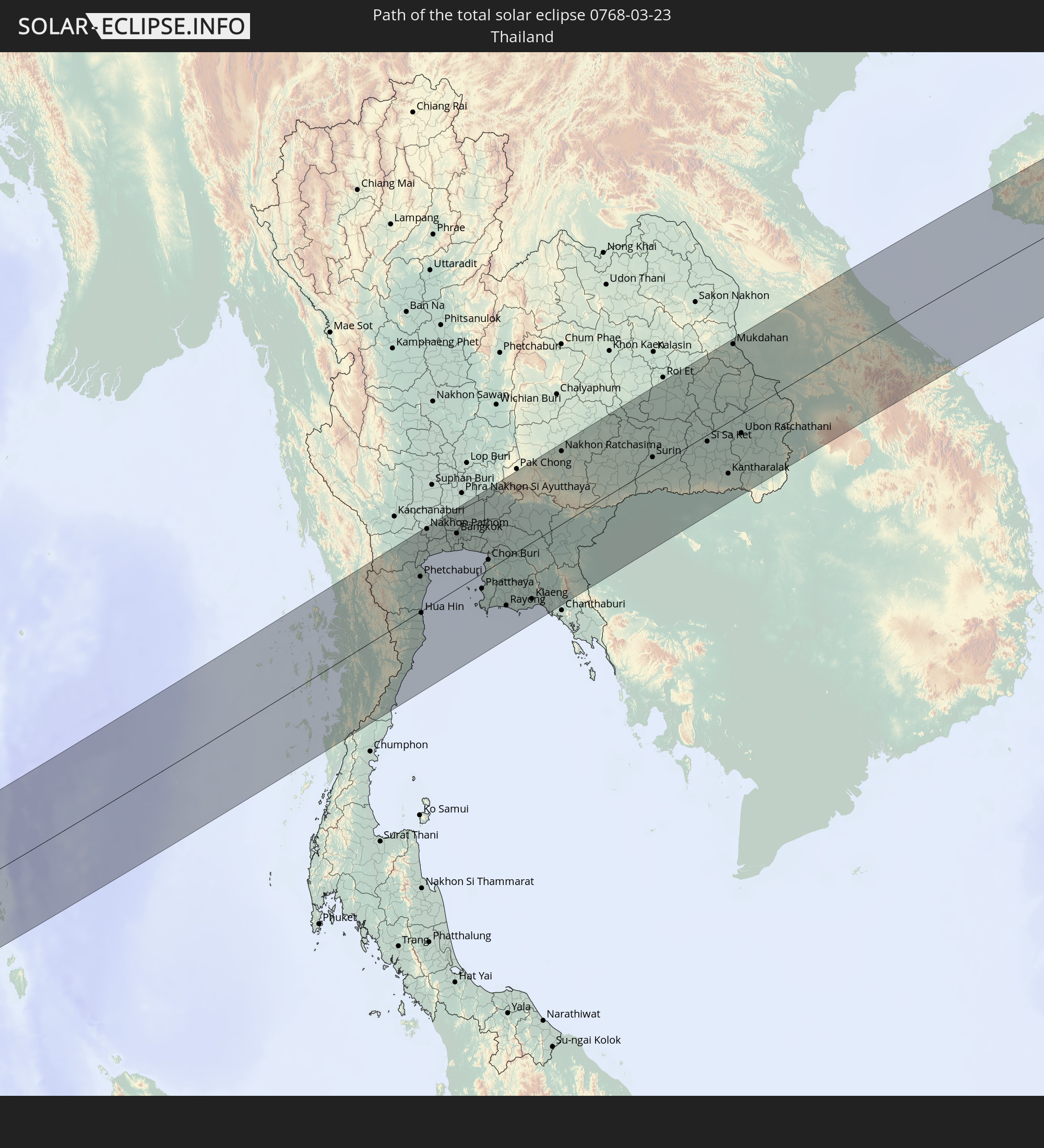 Thailand
 Laos
Laos
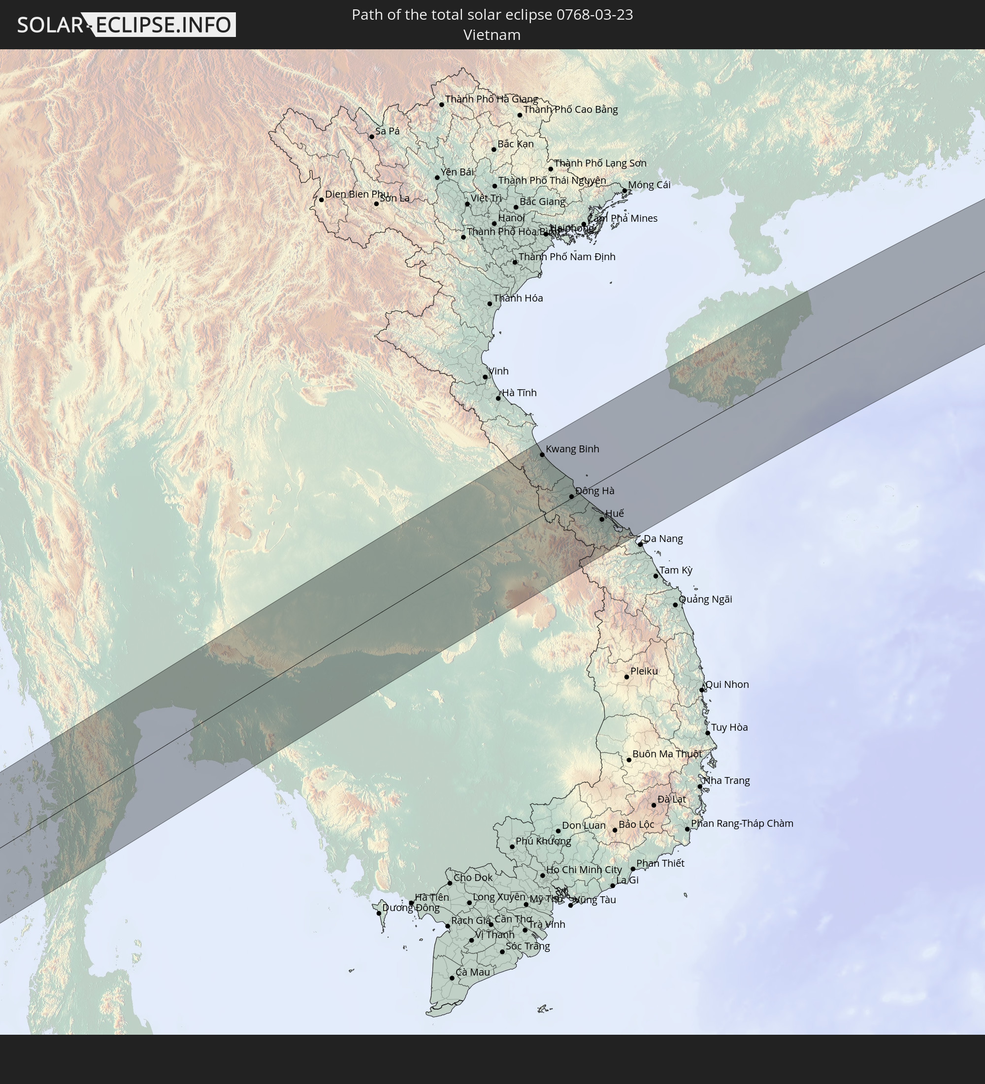 Vietnam
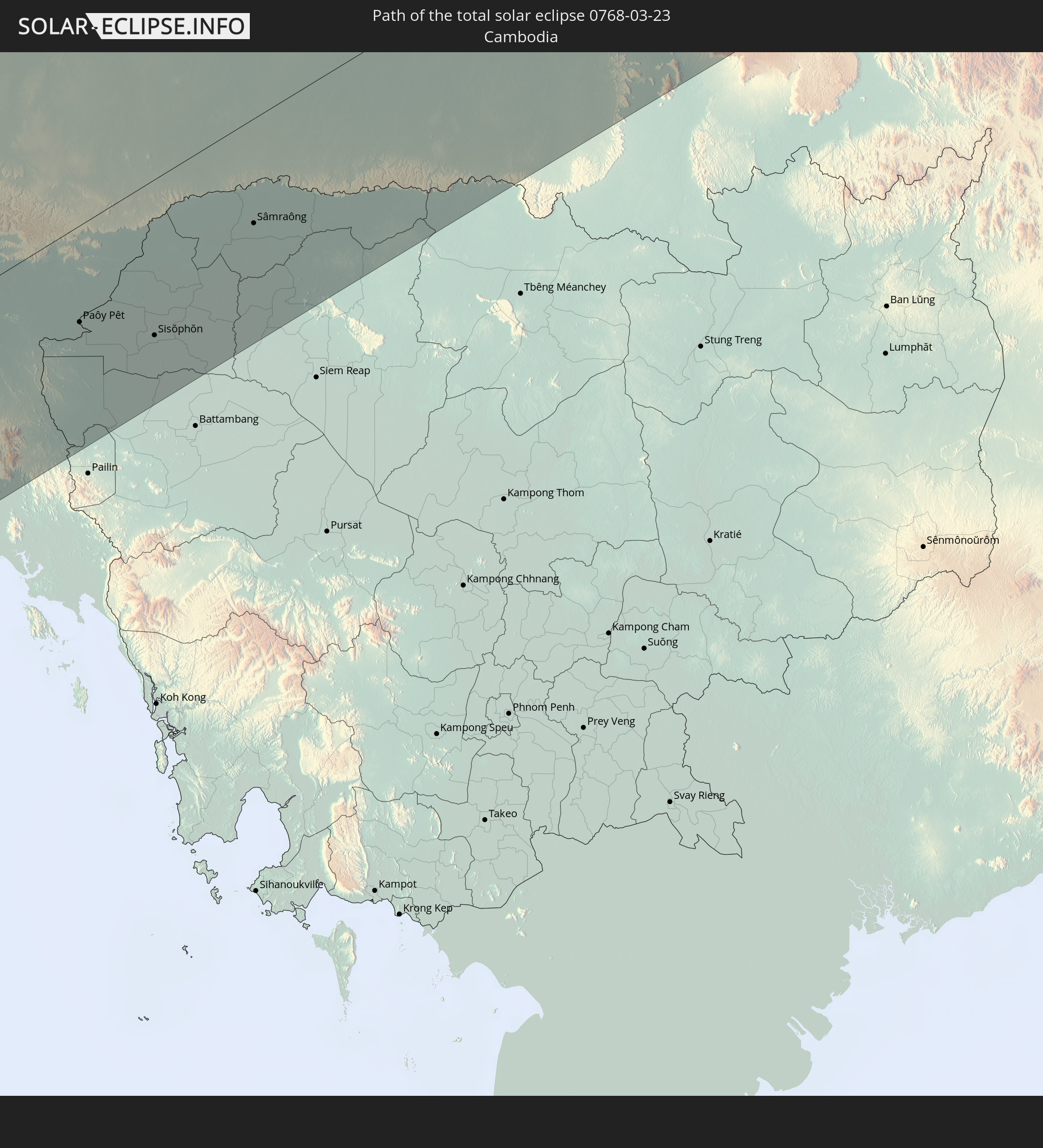 Cambodia
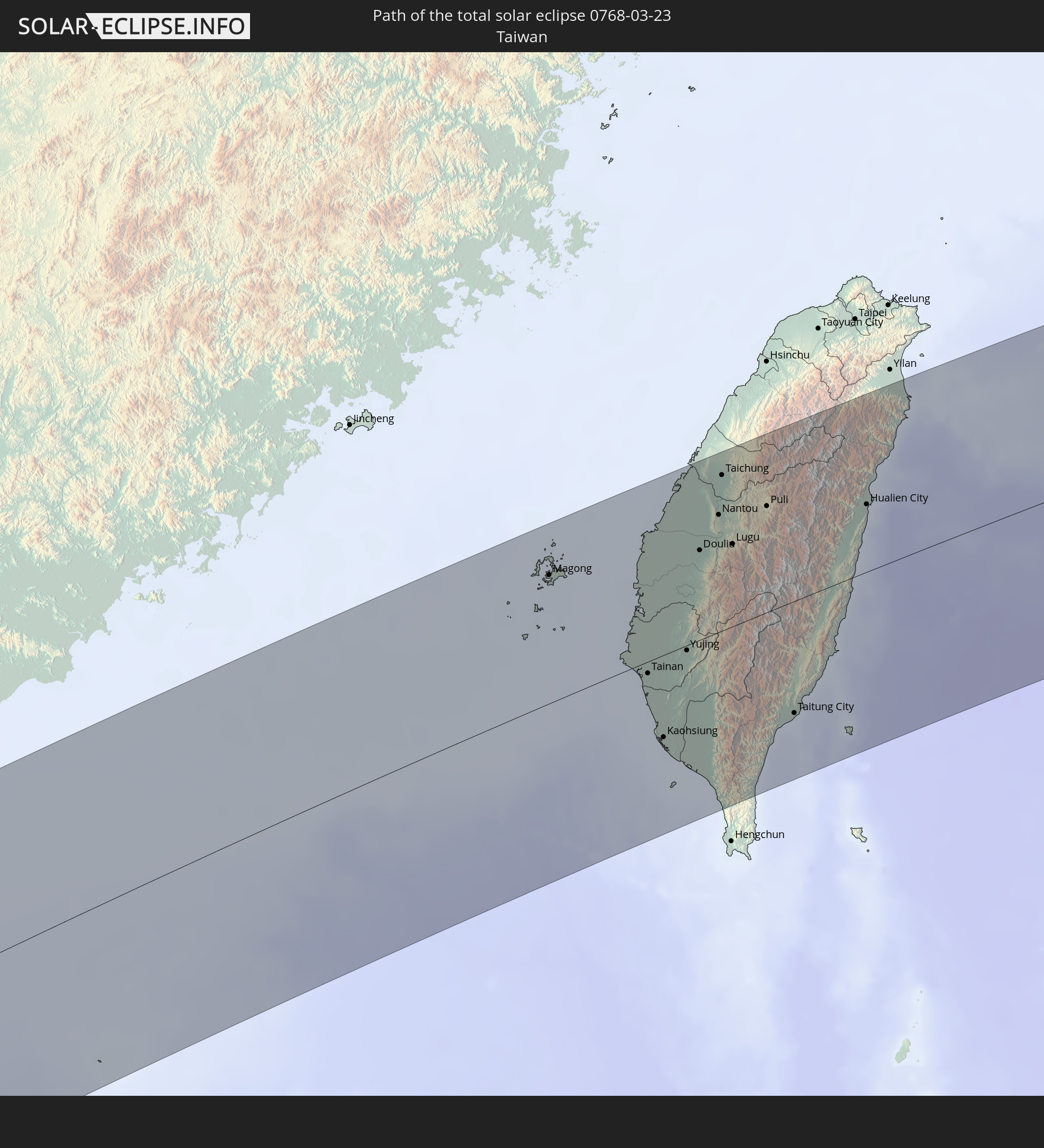 Taiwan
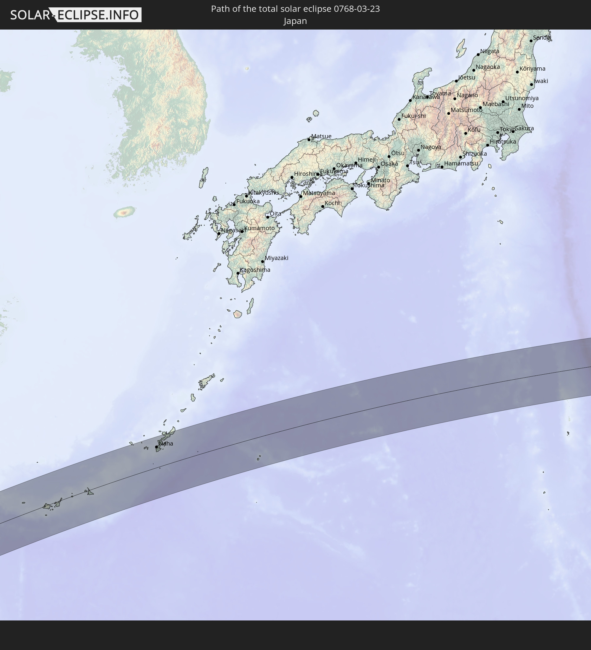 Japan
Japan
In den folgenden Ländern ist die Sonnenfinsternis partiell zu sehen
 Russia
 United States
 United States Minor Outlying Islands
 Kiribati
 Sudan
Sudan
 Egypt
Egypt
 Ethiopia
 Kenya
Kenya
 Israel
 Saudi Arabia
 Jordan
 Eritrea
 Iraq
Iraq
 French Southern and Antarctic Lands
 Somalia
 Djibouti
 Yemen
Yemen
 Madagascar
 Comoros
 Iran
Iran
 Mayotte
 Seychelles
 Kazakhstan
 Kuwait
 Bahrain
 Qatar
Qatar
 United Arab Emirates
 Oman
Oman
 Turkmenistan
 Réunion
 Uzbekistan
 Mauritius
 Afghanistan
 Pakistan
 Tajikistan
 India
India
 Kyrgyzstan
 British Indian Ocean Territory
 Maldives
 China
China
 Sri Lanka
 Nepal
Nepal
 Mongolia
 Bangladesh
 Bhutan
 Myanmar
 Indonesia
 Cocos Islands
 Thailand
 Malaysia
 Laos
Laos
 Vietnam
 Cambodia
 Singapore
 Christmas Island
 Macau
Macau
 Hong Kong
 Brunei
 Taiwan
 Philippines
 Japan
Japan
 East Timor
 North Korea
 South Korea
 Palau
Palau
 Federated States of Micronesia
 Papua New Guinea
 Guam
Guam
 Northern Mariana Islands
 Marshall Islands
 Nauru
Nauru
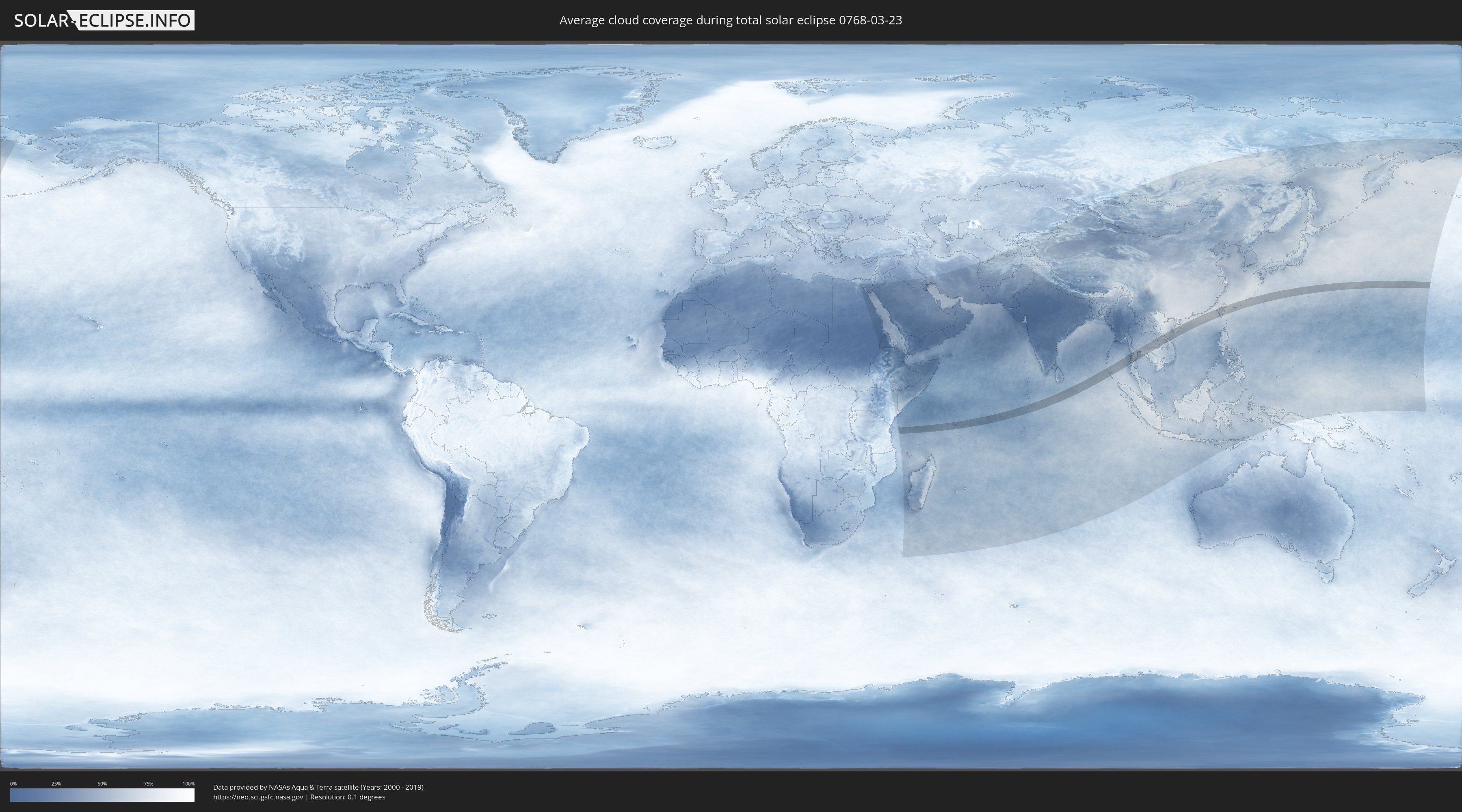
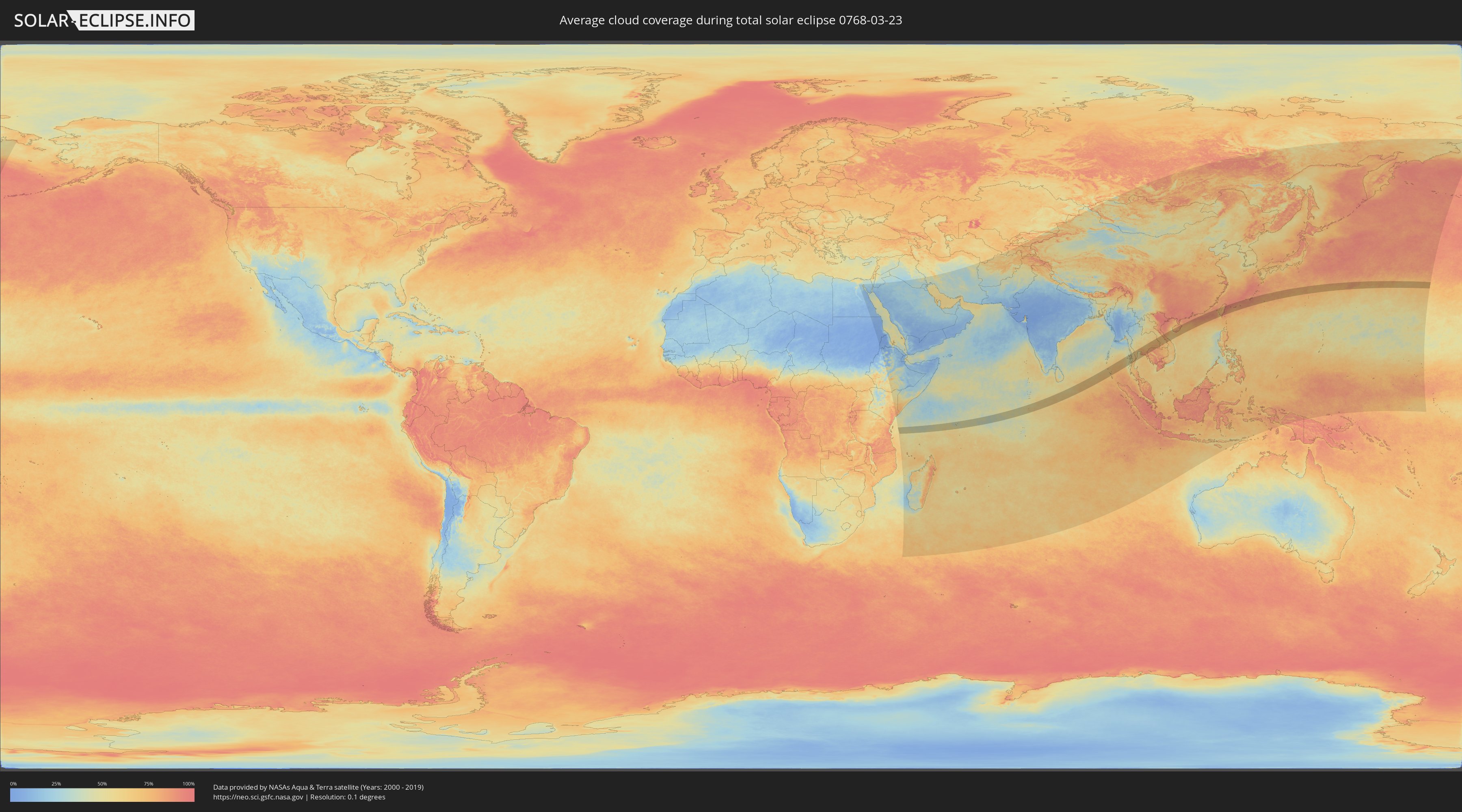
How will be the weather during the total solar eclipse on 03/23/0768?
Where is the best place to see the total solar eclipse of 03/23/0768?
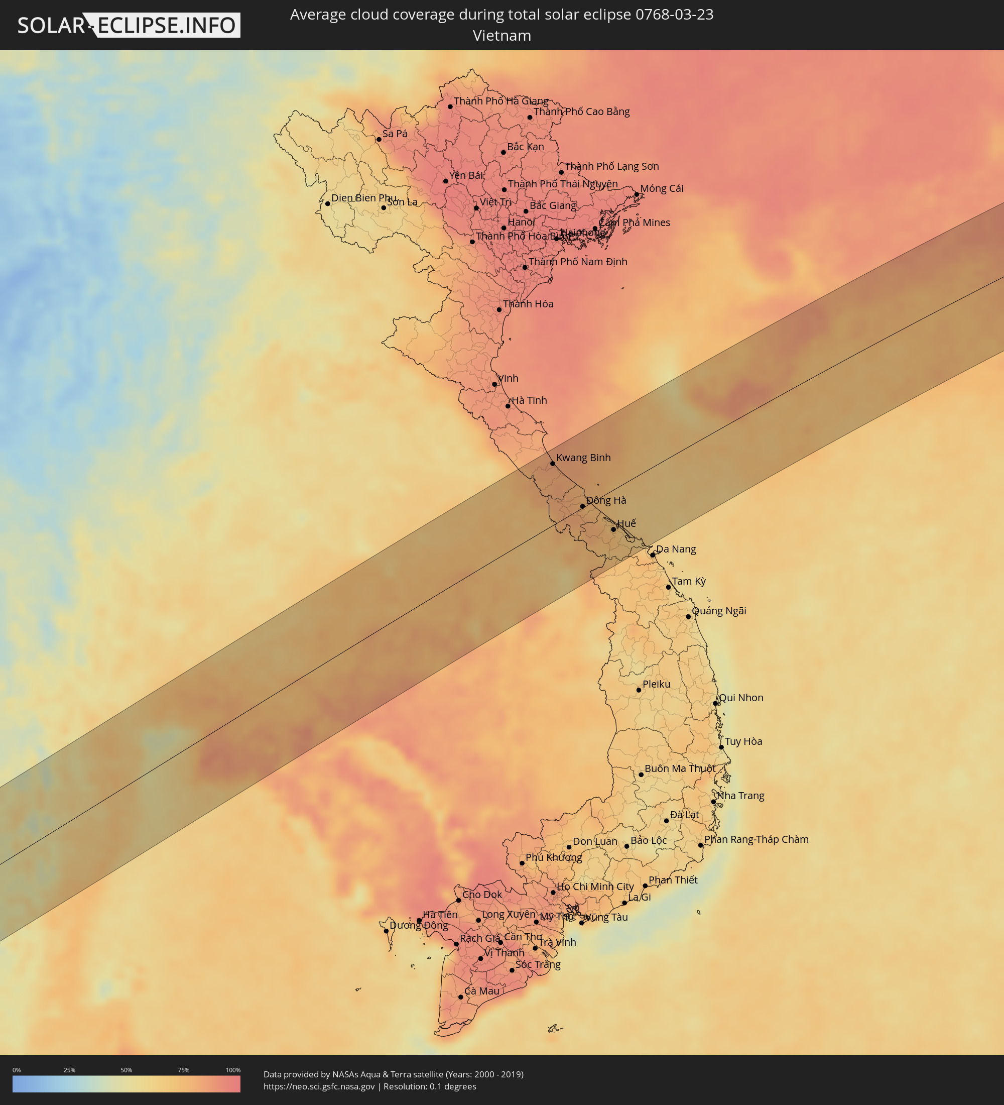
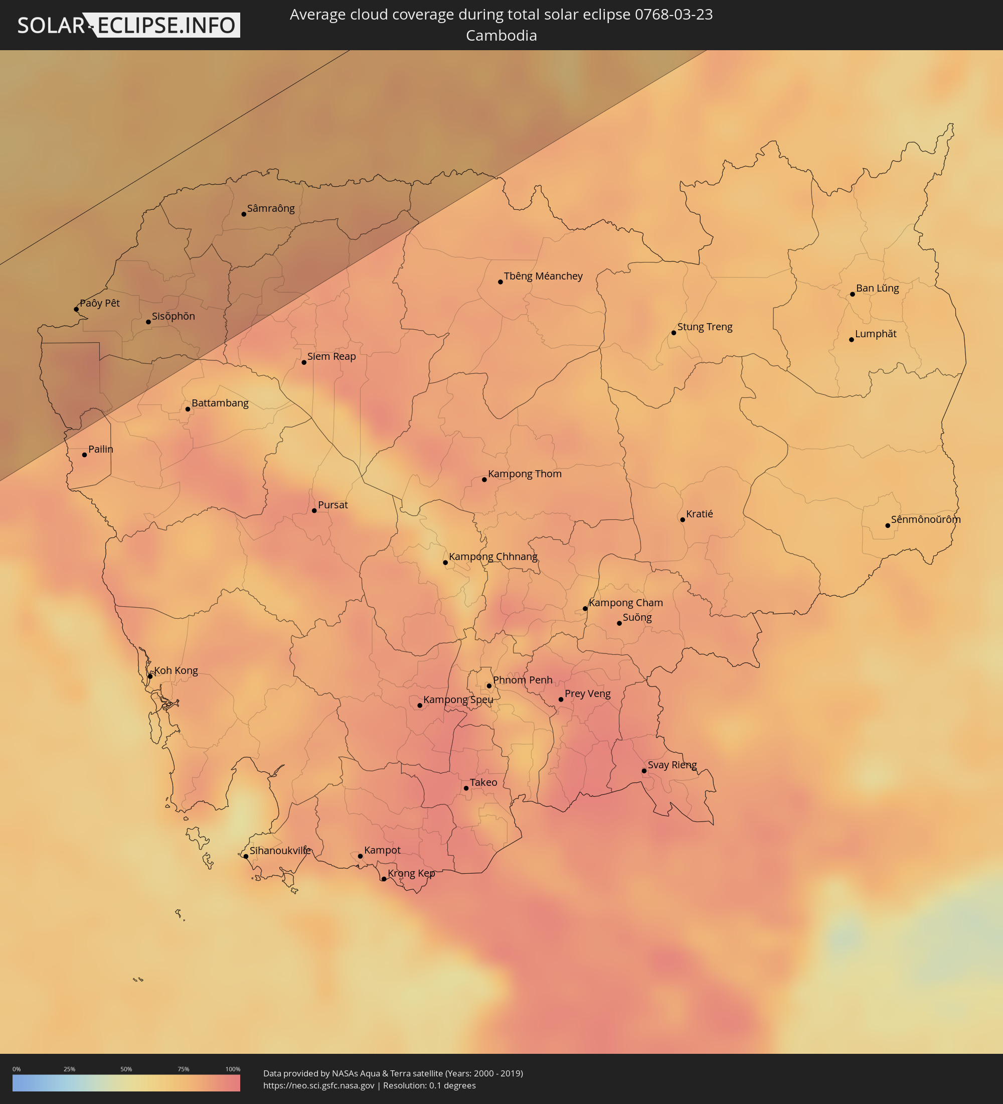
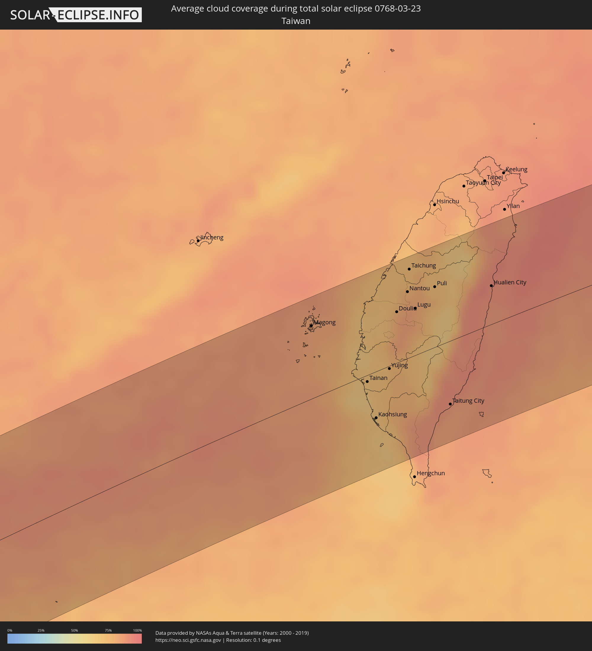
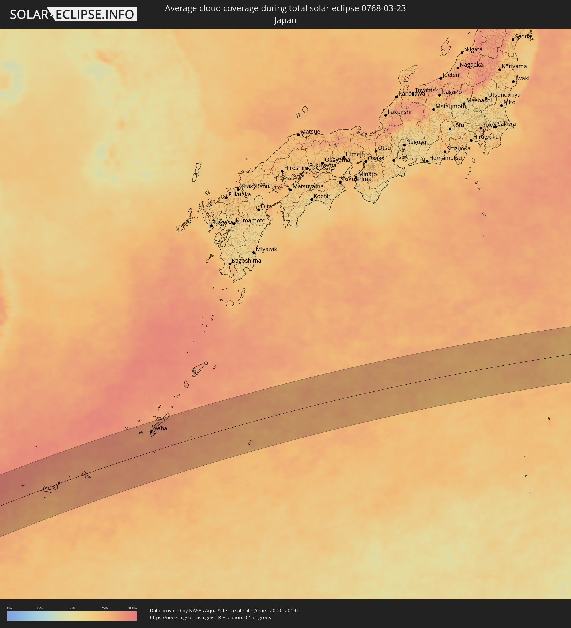
The following maps show the average cloud coverage for the day of the total solar eclipse.
With the help of these maps, it is possible to find the place along the eclipse path, which has the best
chance of a cloudless sky.
Nevertheless, you should consider local circumstances and inform about the weather of your chosen
observation site.
The data is provided by NASAs satellites
AQUA and TERRA.
The cloud maps are averaged over a period of 19 years (2000 - 2019).
Detailed country maps
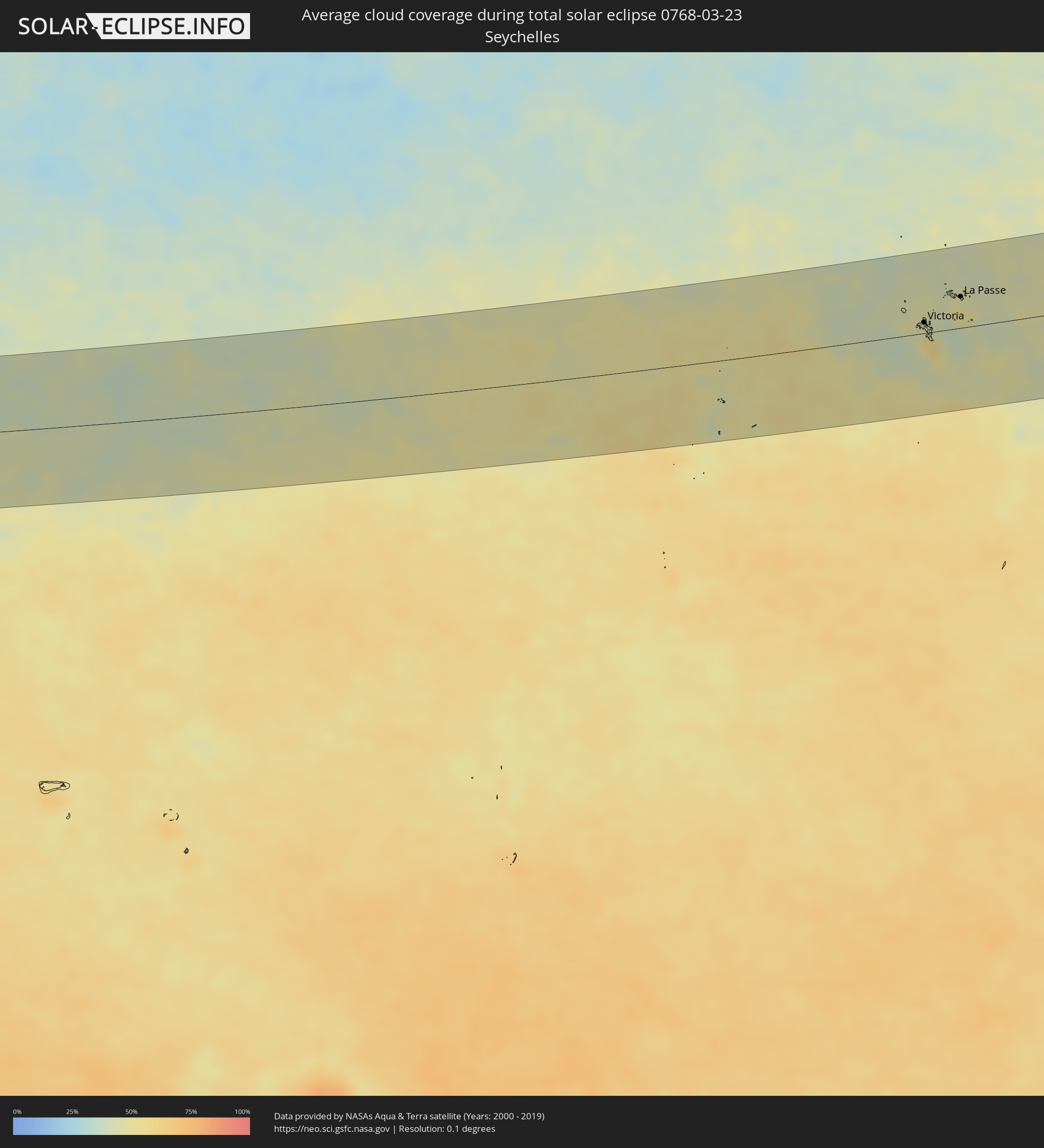 Seychelles
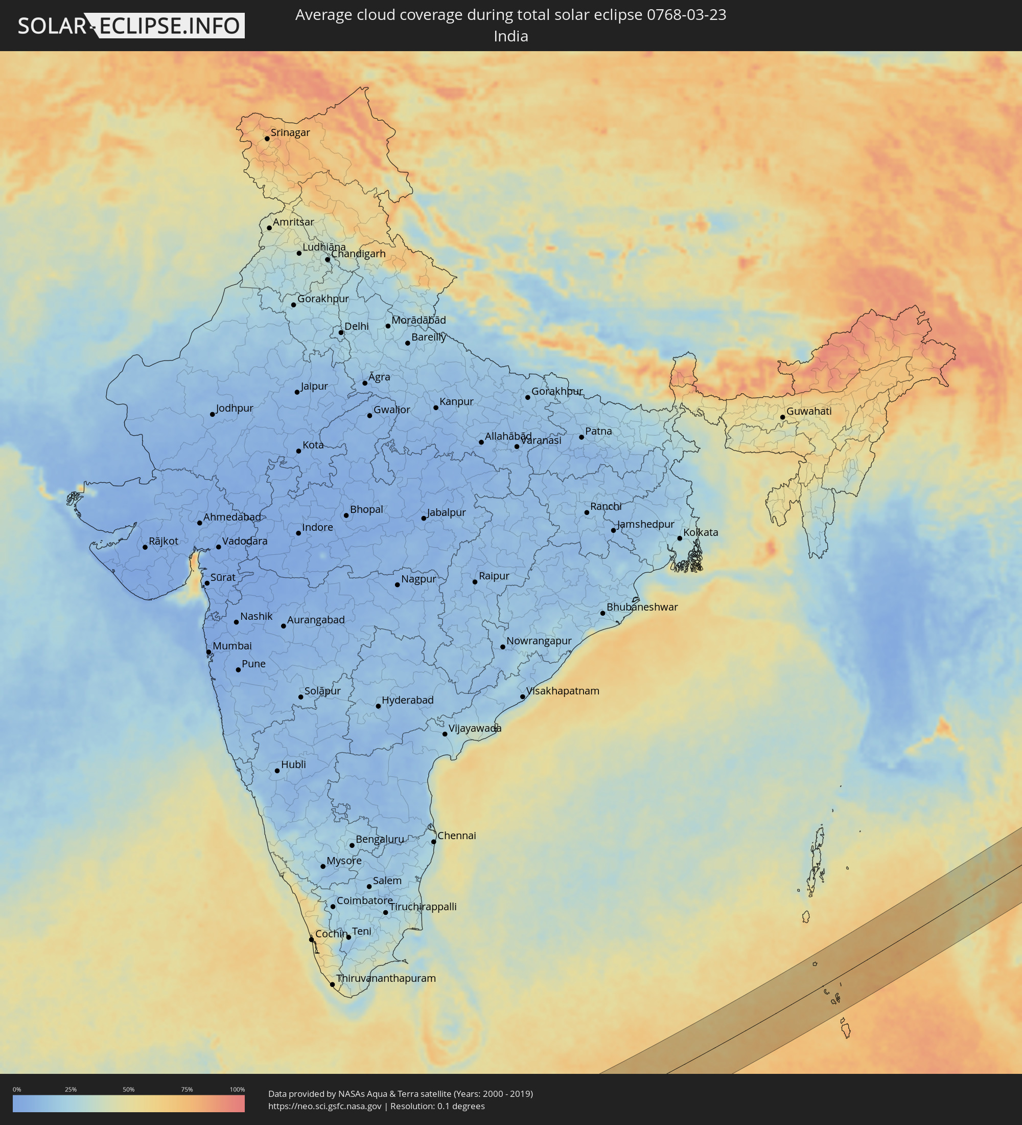 India
India
 Maldives
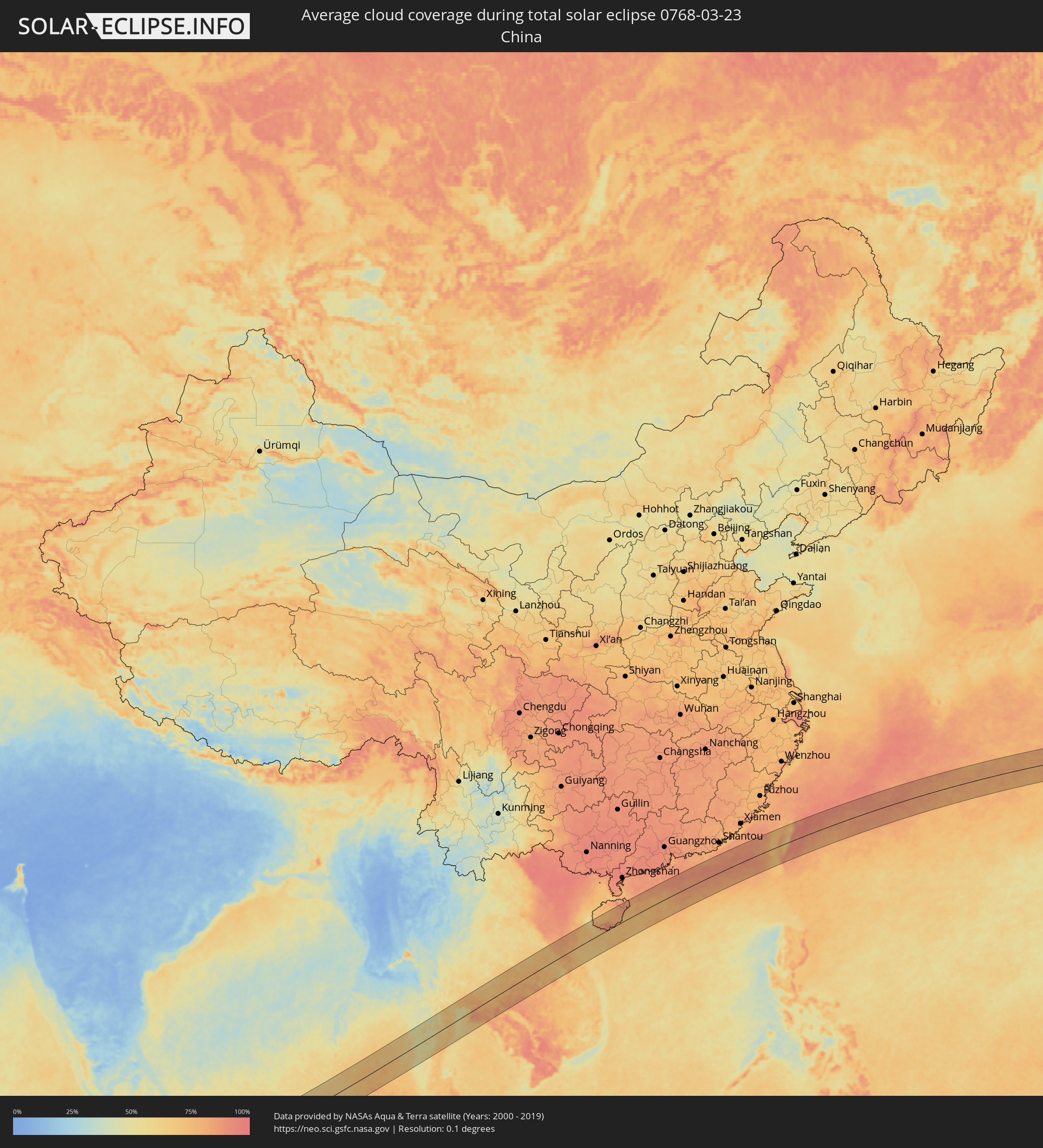 China
China
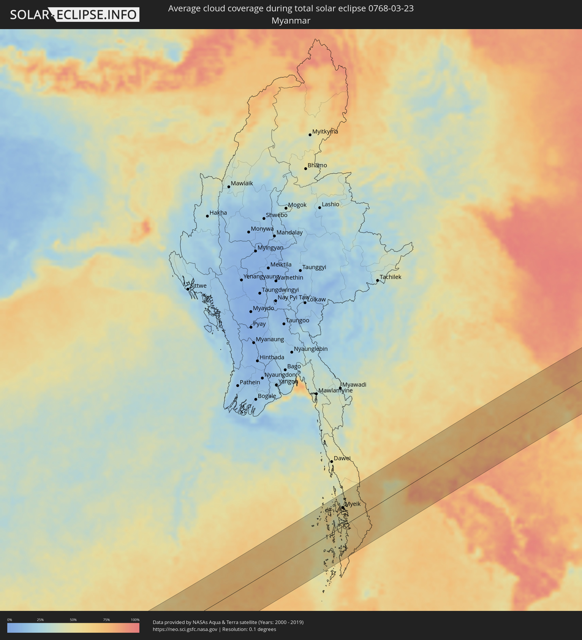 Myanmar
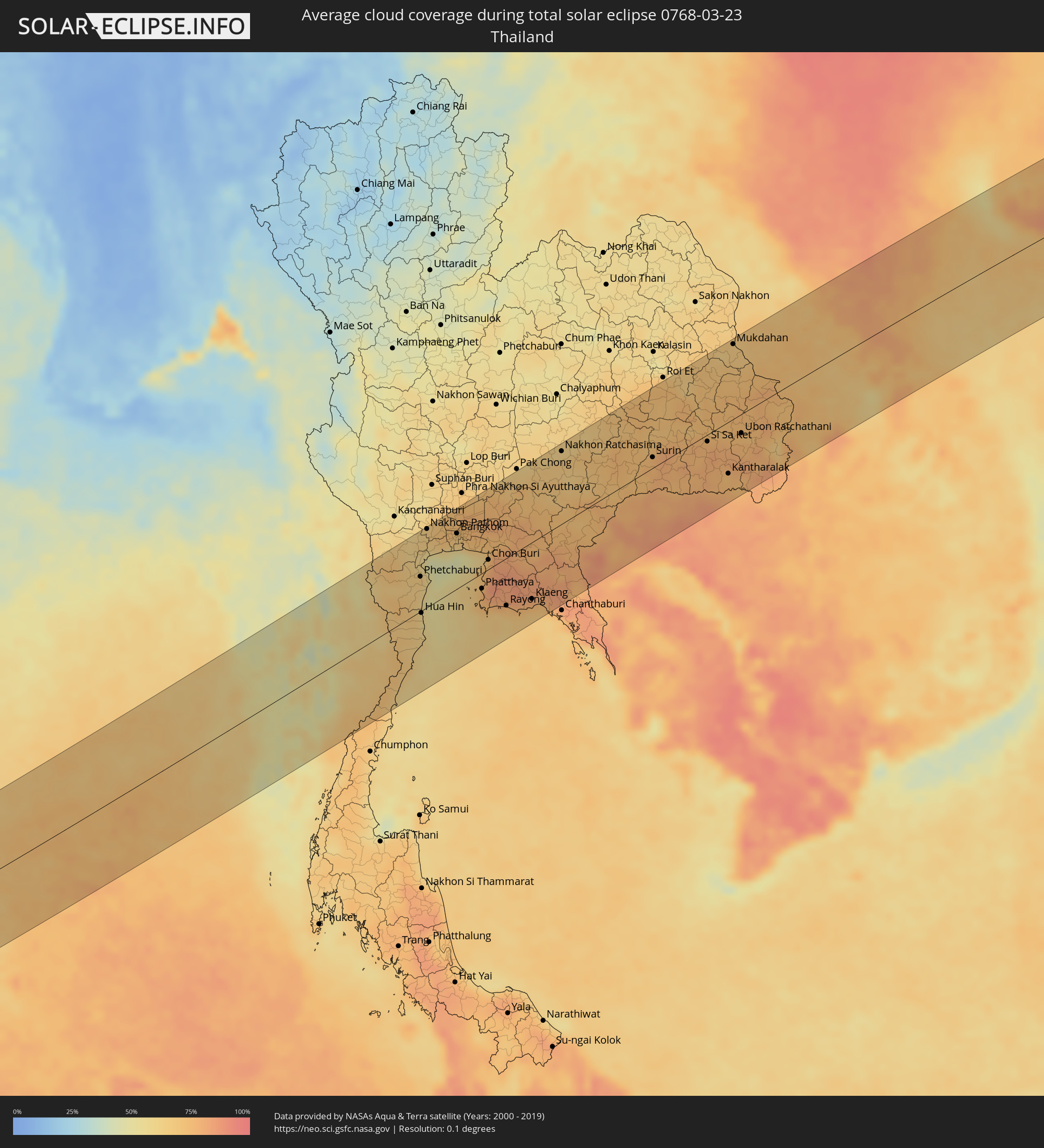 Thailand
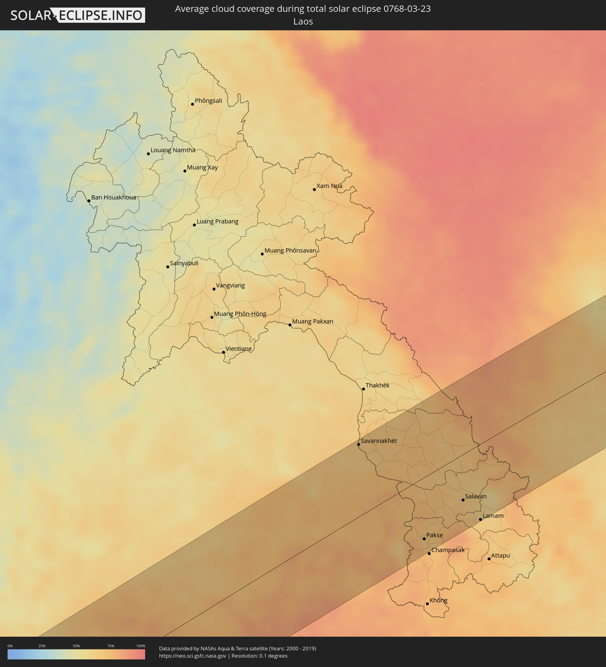 Laos
Laos
 Vietnam
 Cambodia
 Taiwan
 Japan
Japan
Cities inside the path of the eclipse
The following table shows all locations with a population of more than 5,000 inside the eclipse path. Cities which have more than 100,000 inhabitants are marked bold. A click at the locations opens a detailed map.
| City | Type | Eclipse duration | Local time of max. eclipse | Distance to central line | Ø Cloud coverage |
|
Port Glaud, Port Glaud
|
total | - | 07:07:31 UTC+03:41 | 7 km | 48% |
|
Bel Ombre, Bel Ombre
|
total | - | 07:07:32 UTC+03:41 | 13 km | 55% |
|
Beau Vallon, Beau Vallon
|
total | - | 07:07:33 UTC+03:41 | 12 km | 55% |
|
Victoria, English River
|
total | - | 07:07:33 UTC+03:41 | 12 km | 57% |
|
Anse Boileau, Anse Boileau
|
total | - | 07:07:31 UTC+03:41 | 1 km | 59% |
|
Takamaka, Takamaka
|
total | - | 07:07:30 UTC+03:41 | 5 km | 51% |
|
Cascade, Cascade
|
total | - | 07:07:33 UTC+03:41 | 6 km | 59% |
|
Anse Royale, Anse Royale
|
total | - | 07:07:31 UTC+03:41 | 2 km | 59% |
|
La Passe, Inner Islands
|
total | - | 07:07:54 UTC+03:41 | 36 km | 52% |
|
Hithadhoo
|
total | - | 08:38:02 UTC+04:54 | 12 km | 67% |
|
Fuvahmulah, Gnyaviyani Atoll
|
total | - | 08:38:47 UTC+04:54 | 32 km | 60% |
|
Myeik, Tanintharyi
|
total | - | 11:16:42 UTC+06:24 | 63 km | 55% |
|
Ratchaburi, Ratchaburi
|
total | - | 11:38:40 UTC+06:42 | 96 km | 61% |
|
Pran Buri, Prachuap Khiri Khan
|
total | - | 11:37:05 UTC+06:42 | 17 km | 63% |
|
Hua Hin, Prachuap Khiri Khan
|
total | - | 11:37:31 UTC+06:42 | 3 km | 57% |
|
Cha-am, Phetchaburi
|
total | - | 11:37:54 UTC+06:42 | 18 km | 57% |
|
Nakhon Pathom, Nakhon Pathom
|
total | - | 11:39:40 UTC+06:42 | 110 km | 64% |
|
Krathum Baen, Samut Sakhon
|
total | - | 11:39:56 UTC+06:42 | 82 km | 71% |
|
Pak Kret, Nonthaburi
|
total | - | 11:40:56 UTC+06:42 | 93 km | 72% |
|
Bangkok, Bangkok
|
total | - | 11:40:41 UTC+06:42 | 78 km | 68% |
|
Samut Prakan, Samut Prakan
|
total | - | 11:40:41 UTC+06:42 | 58 km | 62% |
|
Khlong Luang, Pathum Thani
|
total | - | 11:41:31 UTC+06:42 | 99 km | 76% |
|
Ban Lam Luk Ka, Pathum Thani
|
total | - | 11:41:43 UTC+06:42 | 83 km | 77% |
|
Phatthaya, Chon Buri
|
total | - | 11:40:22 UTC+06:42 | 22 km | 76% |
|
Sattahip, Chon Buri
|
total | - | 11:39:59 UTC+06:42 | 48 km | 75% |
|
Si Racha, Chon Buri
|
total | - | 11:40:51 UTC+06:42 | 2 km | 73% |
|
Chon Buri, Chon Buri
|
total | - | 11:41:16 UTC+06:42 | 13 km | 74% |
|
Chachoengsao, Chachoengsao
|
total | - | 11:42:00 UTC+06:42 | 39 km | 74% |
|
Rayong, Rayong
|
total | - | 11:40:54 UTC+06:42 | 67 km | 75% |
|
Klaeng, Rayong
|
total | - | 11:42:01 UTC+06:42 | 80 km | 80% |
|
Nakhon Ratchasima, Nakhon Ratchasima
|
total | - | 11:46:29 UTC+06:42 | 102 km | 64% |
|
Paôy Pêt, Banteay Meanchey
|
total | - | 11:45:38 UTC+06:42 | 49 km | 76% |
|
Sisŏphŏn, Banteay Meanchey
|
total | - | 11:46:33 UTC+06:42 | 79 km | 77% |
|
Sâmraông, Ŏtâr Méanchey
|
total | - | 11:48:48 UTC+06:42 | 53 km | 80% |
|
Savannakhét, Savannahkhét
|
total | - | 11:55:20 UTC+06:42 | 105 km | 67% |
|
Ubon Ratchathani, Changwat Ubon Ratchathani
|
total | - | 11:53:40 UTC+06:42 | 27 km | 76% |
|
Pakse, Champasak
|
total | - | 11:55:51 UTC+06:42 | 91 km | 73% |
|
Salavan, Salavan
|
total | - | 11:58:14 UTC+06:42 | 67 km | 67% |
|
Kwang Binh, Quảng Bình
|
total | - | 12:25:45 UTC+07:06 | 89 km | 82% |
|
Lamam, Xékong
|
total | - | 11:58:30 UTC+06:42 | 111 km | 70% |
|
Ðông Hà, Quảng Trị
|
total | - | 12:26:02 UTC+07:06 | 1 km | 80% |
|
Huế, Thừa Thiên-Huế
|
total | - | 12:26:46 UTC+07:06 | 60 km | 72% |
|
Sanya, Hainan
|
total | - | 13:27:03 UTC+08:00 | 12 km | 74% |
|
Wanning, Hainan
|
total | - | 13:29:49 UTC+08:00 | 21 km | 78% |
|
Magong, Taiwan
|
total | - | 13:54:42 UTC+08:00 | 77 km | 82% |
|
Tainan, Taiwan
|
total | - | 13:55:33 UTC+08:00 | 7 km | 68% |
|
Kaohsiung, Takao
|
total | - | 13:55:29 UTC+08:00 | 49 km | 70% |
|
Yujing, Taiwan
|
total | - | 13:56:08 UTC+08:00 | 3 km | 77% |
|
Douliu, Taiwan
|
total | - | 13:56:42 UTC+08:00 | 54 km | 77% |
|
Nantou, Taiwan
|
total | - | 13:57:04 UTC+08:00 | 70 km | 81% |
|
Taichung, Taiwan
|
total | - | 13:57:16 UTC+08:00 | 93 km | 75% |
|
Zhongxing New Village, Taiwan
|
total | - | 13:57:09 UTC+08:00 | 74 km | 78% |
|
Lugu, Taiwan
|
total | - | 13:57:08 UTC+08:00 | 49 km | 79% |
|
Puli, Taiwan
|
total | - | 13:57:42 UTC+08:00 | 64 km | 74% |
|
Taitung City, Taiwan
|
total | - | 13:57:15 UTC+08:00 | 68 km | 88% |
|
Hualien City, Taiwan
|
total | - | 13:58:57 UTC+08:00 | 41 km | 91% |
|
Ishigaki, Okinawa
|
total | - | 15:03:57 UTC+09:00 | 14 km | 83% |
|
Hirara, Okinawa
|
total | - | 15:06:14 UTC+09:00 | 5 km | 87% |
|
Itoman, Okinawa
|
total | - | 15:10:47 UTC+09:00 | 59 km | 87% |
|
Tomigusuku, Okinawa
|
total | - | 15:10:50 UTC+09:00 | 65 km | 88% |
|
Naha, Okinawa
|
total | - | 15:10:51 UTC+09:00 | 68 km | 88% |
|
Ginowan, Okinawa
|
total | - | 15:10:59 UTC+09:00 | 71 km | 87% |
|
Chatan, Okinawa
|
total | - | 15:11:01 UTC+09:00 | 75 km | 87% |
|
Okinawa, Okinawa
|
total | - | 15:11:04 UTC+09:00 | 77 km | 87% |
|
Ishikawa, Okinawa
|
total | - | 15:11:08 UTC+09:00 | 86 km | 88% |
|
Gushikawa, Okinawa
|
total | - | 15:11:11 UTC+09:00 | 78 km | 87% |
|
Katsuren-haebaru, Okinawa
|
total | - | 15:11:11 UTC+09:00 | 75 km | 86% |
|
Nago, Okinawa
|
total | - | 15:11:27 UTC+09:00 | 101 km | 88% |