Total solar eclipse of 04/13/0804
| Day of week: | Tuesday |
| Maximum duration of eclipse: | 06m03s |
| Maximum width of eclipse path: | 250 km |
| Saros cycle: | 90 |
| Coverage: | 100% |
| Magnitude: | 1.0732 |
| Gamma: | 0.3118 |
Wo kann man die Sonnenfinsternis vom 04/13/0804 sehen?
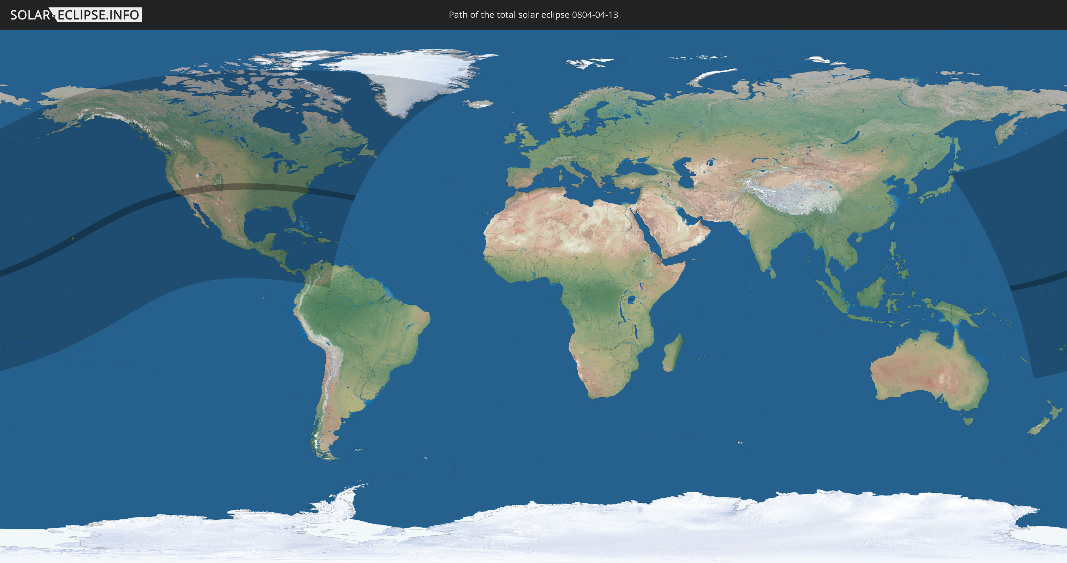
Die Sonnenfinsternis am 04/13/0804 kann man in 43 Ländern als partielle Sonnenfinsternis beobachten.
Der Finsternispfad verläuft durch 2 Länder. Nur in diesen Ländern ist sie als total Sonnenfinsternis zu sehen.
In den folgenden Ländern ist die Sonnenfinsternis total zu sehen
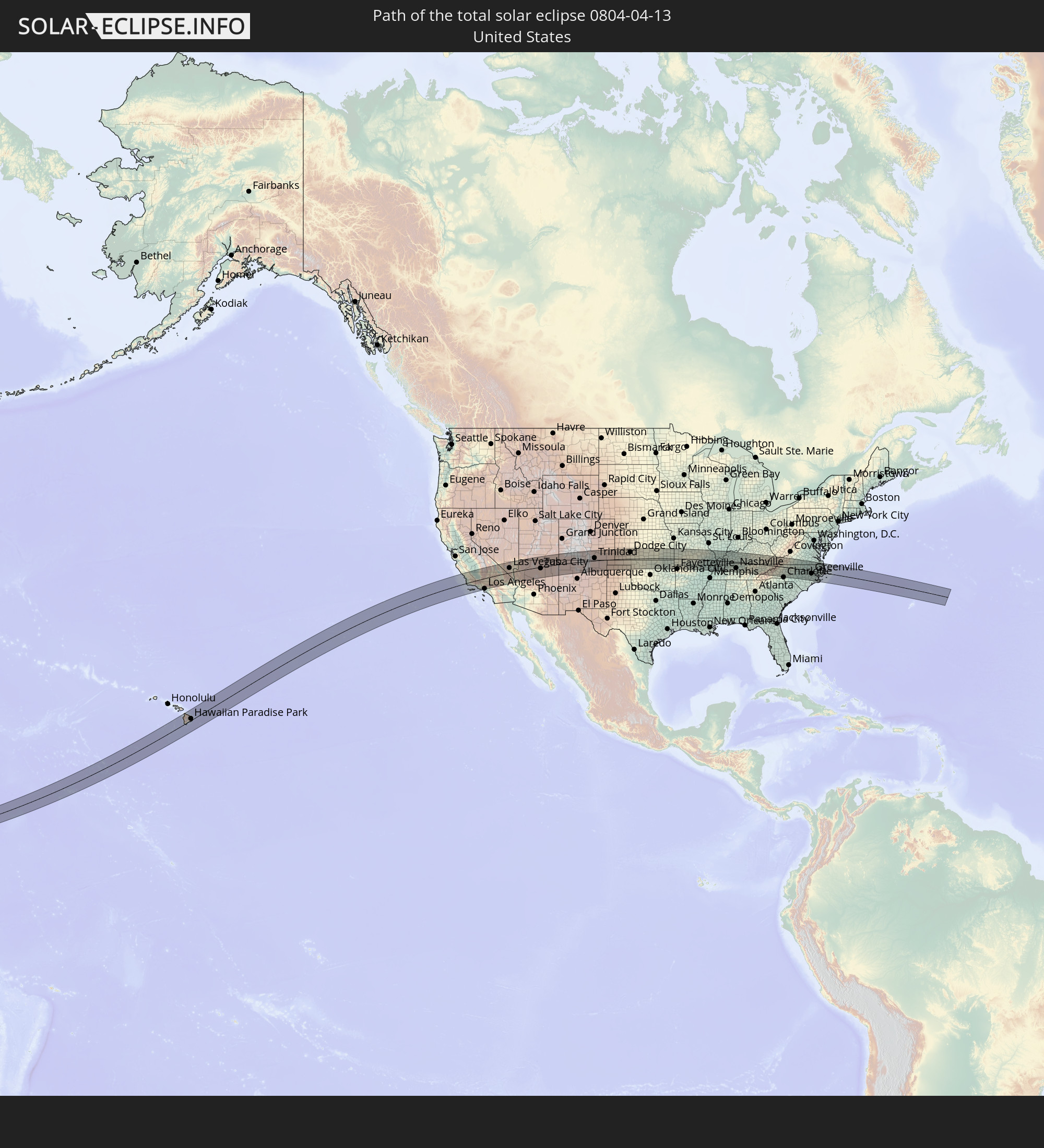 United States
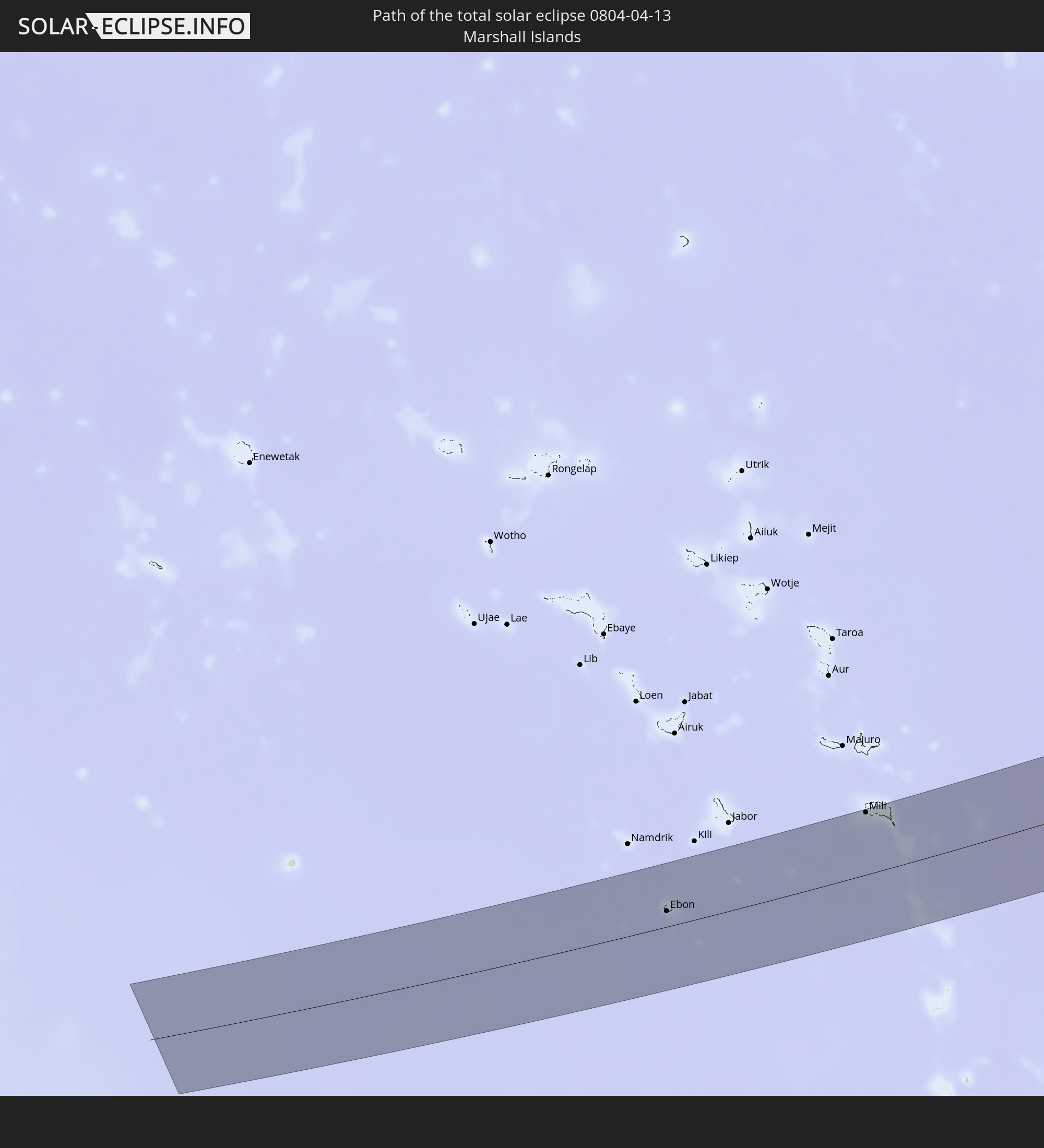 Marshall Islands
In den folgenden Ländern ist die Sonnenfinsternis partiell zu sehen
 Fiji
Fiji
 United States
 United States Minor Outlying Islands
 Wallis and Futuna
 Tonga
Tonga
 Kiribati
 Samoa
Samoa
 Tokelau
 American Samoa
 Niue
Niue
 Cook Islands
 French Polynesia
 Canada
 Mexico
 Greenland
 Guatemala
 El Salvador
 Honduras
 Belize
 Nicaragua
 Costa Rica
 Cuba
Cuba
 Panama
 Colombia
 Cayman Islands
 The Bahamas
 Jamaica
 Haiti
Haiti
 Venezuela
 Turks and Caicos Islands
 Dominican Republic
 Aruba
Aruba
 Puerto Rico
 Bermuda
 Saint Pierre and Miquelon
 Japan
Japan
 Federated States of Micronesia
 Solomon Islands
 New Caledonia
 Marshall Islands
 Vanuatu
 Nauru
Nauru
 Tuvalu
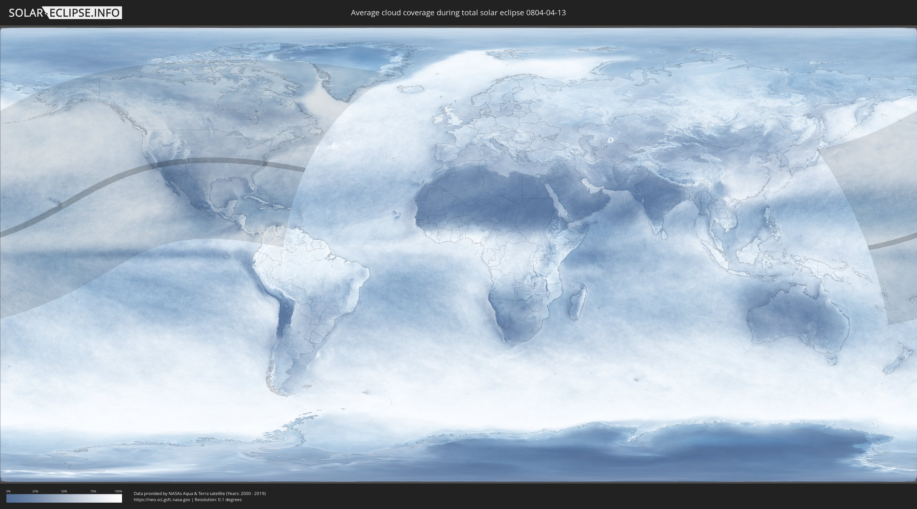
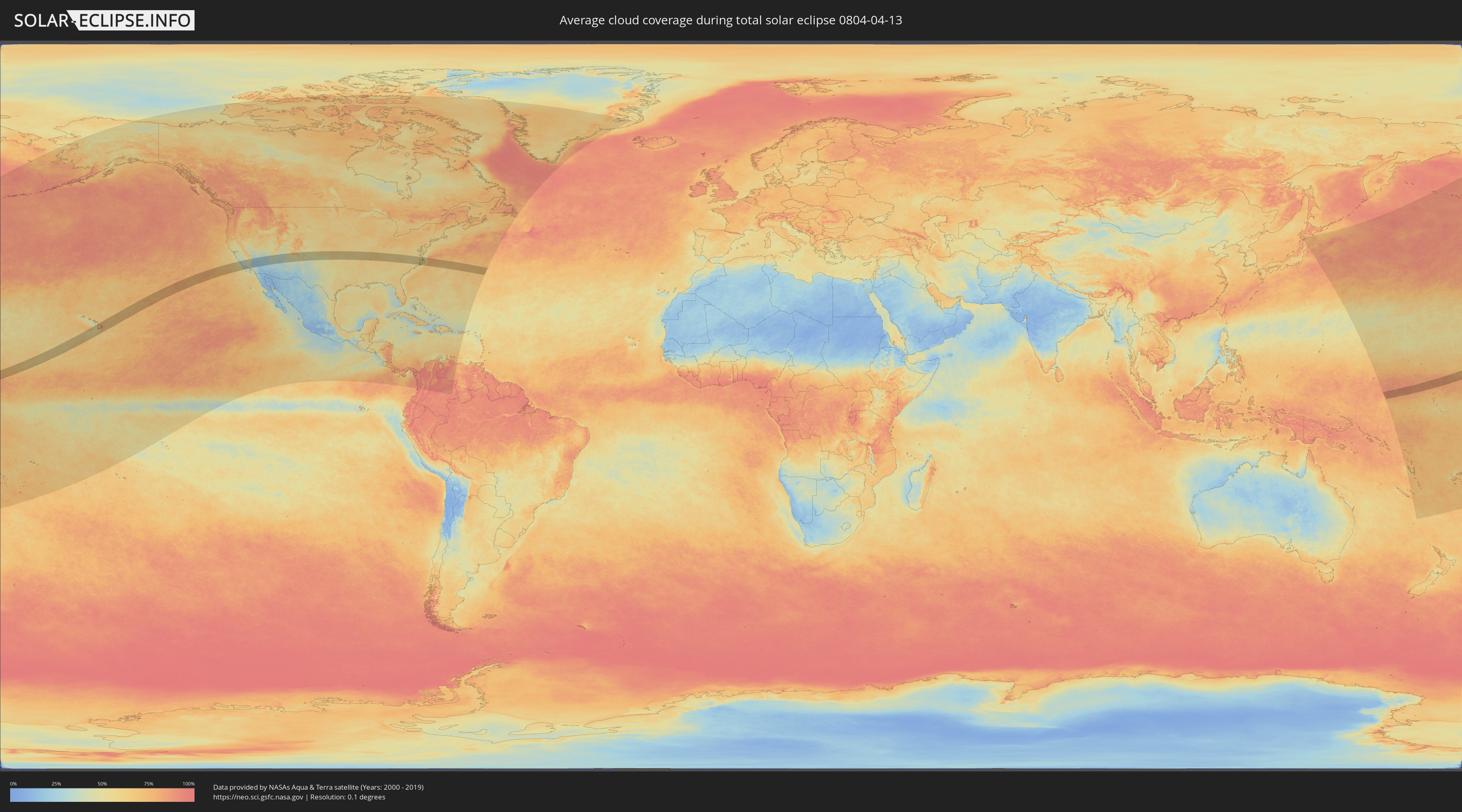
How will be the weather during the total solar eclipse on 04/13/0804?
Where is the best place to see the total solar eclipse of 04/13/0804?
The following maps show the average cloud coverage for the day of the total solar eclipse.
With the help of these maps, it is possible to find the place along the eclipse path, which has the best
chance of a cloudless sky.
Nevertheless, you should consider local circumstances and inform about the weather of your chosen
observation site.
The data is provided by NASAs satellites
AQUA and TERRA.
The cloud maps are averaged over a period of 19 years (2000 - 2019).
Detailed country maps
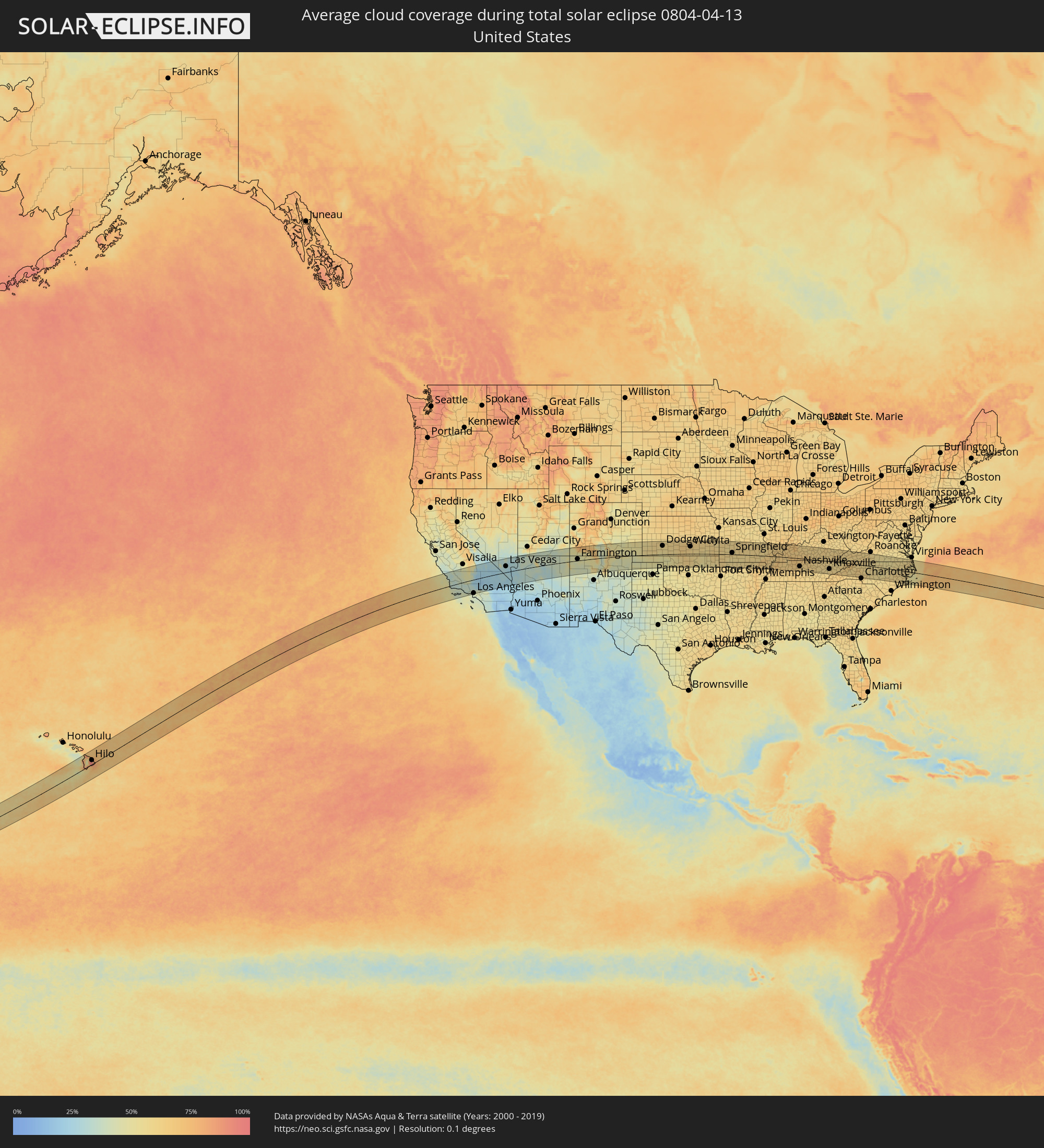 United States
 Marshall Islands
Cities inside the path of the eclipse
The following table shows all locations with a population of more than 5,000 inside the eclipse path. Cities which have more than 100,000 inhabitants are marked bold. A click at the locations opens a detailed map.
| City | Type | Eclipse duration | Local time of max. eclipse | Distance to central line | Ø Cloud coverage |
|
Hilo, Hawaii
|
total | - | 09:34:33 UTC-10:30 | 35 km | 92% |
|
Paso Robles, California
|
total | - | 13:34:57 UTC-08:00 | 111 km | 37% |
|
Atascadero, California
|
total | - | 13:34:57 UTC-08:00 | 95 km | 35% |
|
San Luis Obispo, California
|
total | - | 13:34:55 UTC-08:00 | 73 km | 33% |
|
Lompoc, California
|
total | - | 13:35:07 UTC-08:00 | 1 km | 38% |
|
Santa Maria, California
|
total | - | 13:35:15 UTC-08:00 | 32 km | 38% |
|
Santa Barbara, California
|
total | - | 13:36:32 UTC-08:00 | 43 km | 40% |
|
Wasco, California
|
total | - | 13:37:29 UTC-08:00 | 75 km | 42% |
|
Delano, California
|
total | - | 13:37:42 UTC-08:00 | 92 km | 44% |
|
Oxnard, California
|
total | - | 13:37:29 UTC-08:00 | 79 km | 38% |
|
Santa Paula, California
|
total | - | 13:37:45 UTC-08:00 | 65 km | 35% |
|
Bakersfield, California
|
total | - | 13:38:03 UTC-08:00 | 44 km | 47% |
|
Porterville, California
|
total | - | 13:38:11 UTC-08:00 | 118 km | 49% |
|
Thousand Oaks, California
|
total | - | 13:38:07 UTC-08:00 | 90 km | 36% |
|
West Hills, California
|
total | - | 13:38:30 UTC-08:00 | 91 km | 38% |
|
Santa Clarita, California
|
total | - | 13:38:44 UTC-08:00 | 73 km | 36% |
|
Santa Monica, California
|
total | - | 13:38:45 UTC-08:00 | 114 km | 41% |
|
Van Nuys, California
|
total | - | 13:38:53 UTC-08:00 | 97 km | 38% |
|
Los Angeles, California
|
total | - | 13:39:14 UTC-08:00 | 116 km | 42% |
|
Lancaster, California
|
total | - | 13:39:34 UTC-08:00 | 49 km | 26% |
|
Altadena, California
|
total | - | 13:39:29 UTC-08:00 | 104 km | 45% |
|
El Monte, California
|
total | - | 13:39:39 UTC-08:00 | 119 km | 43% |
|
Glendora, California
|
total | - | 13:39:59 UTC-08:00 | 115 km | 43% |
|
Ridgecrest, California
|
total | - | 13:40:35 UTC-08:00 | 41 km | 23% |
|
Victorville, California
|
total | - | 13:41:08 UTC-08:00 | 85 km | 28% |
|
Barstow Heights, California
|
total | - | 13:41:37 UTC-08:00 | 53 km | 22% |
|
Pahrump, Nevada
|
total | - | 13:43:41 UTC-08:00 | 71 km | 28% |
|
Enterprise, Nevada
|
total | - | 13:44:58 UTC-08:00 | 37 km | 26% |
|
Las Vegas, Nevada
|
total | - | 13:45:10 UTC-08:00 | 51 km | 29% |
|
Henderson, Nevada
|
total | - | 13:45:26 UTC-08:00 | 34 km | 25% |
|
Bullhead City, Arizona
|
total | - | 14:46:08 UTC-07:00 | 71 km | 27% |
|
Kingman, Arizona
|
total | - | 14:47:03 UTC-07:00 | 75 km | 29% |
|
Flagstaff, Arizona
|
total | - | 14:51:08 UTC-07:00 | 113 km | 35% |
|
Farmington, New Mexico
|
total | - | 14:56:16 UTC-07:00 | 13 km | 44% |
|
Garden City, Kansas
|
total | - | 16:05:35 UTC-06:00 | 99 km | 59% |
|
Dodge City, Kansas
|
total | - | 16:06:41 UTC-06:00 | 72 km | 57% |
|
Hutchinson, Kansas
|
total | - | 16:08:50 UTC-06:00 | 103 km | 61% |
|
Enid, Oklahoma
|
total | - | 16:09:49 UTC-06:00 | 82 km | 60% |
|
Wichita, Kansas
|
total | - | 16:09:40 UTC-06:00 | 62 km | 63% |
|
Derby, Kansas
|
total | - | 16:09:50 UTC-06:00 | 45 km | 60% |
|
Ponca City, Oklahoma
|
total | - | 16:10:30 UTC-06:00 | 48 km | 58% |
|
Tulsa, Oklahoma
|
total | - | 16:11:58 UTC-06:00 | 109 km | 53% |
|
Bartlesville, Oklahoma
|
total | - | 16:11:38 UTC-06:00 | 43 km | 53% |
|
Owasso, Oklahoma
|
total | - | 16:12:02 UTC-06:00 | 96 km | 53% |
|
Joplin, Missouri
|
total | - | 16:12:52 UTC-06:00 | 4 km | 59% |
|
Bella Vista, Arkansas
|
total | - | 16:13:28 UTC-06:00 | 71 km | 59% |
|
Springdale, Arkansas
|
total | - | 16:13:47 UTC-06:00 | 103 km | 60% |
|
Rogers, Arkansas
|
total | - | 16:13:43 UTC-06:00 | 87 km | 60% |
|
Springfield, Missouri
|
total | - | 16:13:55 UTC-06:00 | 14 km | 61% |
|
Paragould, Arkansas
|
total | - | 16:17:05 UTC-06:00 | 104 km | 63% |
|
Cape Girardeau, Missouri
|
total | - | 16:17:00 UTC-06:00 | 40 km | 62% |
|
Carbondale, Illinois
|
total | - | 16:16:56 UTC-06:00 | 89 km | 61% |
|
Paducah, Kentucky
|
total | - | 16:17:51 UTC-06:00 | 21 km | 63% |
|
Hopkinsville, Kentucky
|
total | - | 16:18:48 UTC-06:00 | 4 km | 68% |
|
Clarksville, Tennessee
|
total | - | 16:19:07 UTC-06:00 | 32 km | 67% |
|
Owensboro, Kentucky
|
total | - | 16:18:24 UTC-06:00 | 108 km | 66% |
|
Franklin, Tennessee
|
total | - | 16:19:53 UTC-06:00 | 96 km | 63% |
|
Nashville, Tennessee
|
total | - | 16:19:46 UTC-06:00 | 68 km | 62% |
|
Hendersonville, Tennessee
|
total | - | 16:19:47 UTC-06:00 | 52 km | 61% |
|
Smyrna, Tennessee
|
total | - | 16:20:05 UTC-06:00 | 87 km | 59% |
|
Gallatin, Tennessee
|
total | - | 16:19:50 UTC-06:00 | 41 km | 62% |
|
Bowling Green, Kentucky
|
total | - | 16:19:25 UTC-06:00 | 26 km | 65% |
|
Murfreesboro, Tennessee
|
total | - | 16:20:16 UTC-06:00 | 101 km | 60% |
|
Lebanon, Tennessee
|
total | - | 16:20:04 UTC-06:00 | 60 km | 62% |
|
Elizabethtown, Kentucky
|
total | - | 17:19:16 UTC-05:00 | 108 km | 62% |
|
Cookeville, Tennessee
|
total | - | 16:20:37 UTC-06:00 | 58 km | 61% |
|
Oak Ridge, Tennessee
|
total | - | 17:21:28 UTC-05:00 | 64 km | 57% |
|
Maryville, Tennessee
|
total | - | 17:21:49 UTC-05:00 | 89 km | 58% |
|
Knoxville, Tennessee
|
total | - | 17:21:42 UTC-05:00 | 66 km | 57% |
|
Morristown, Tennessee
|
total | - | 17:21:52 UTC-05:00 | 32 km | 58% |
|
Kingsport, Tennessee
|
total | - | 17:22:01 UTC-05:00 | 12 km | 59% |
|
Asheville, North Carolina
|
total | - | 17:22:43 UTC-05:00 | 93 km | 61% |
|
Johnson City, Tennessee
|
total | - | 17:22:18 UTC-05:00 | 12 km | 63% |
|
Bristol, Tennessee
|
total | - | 17:22:11 UTC-05:00 | 21 km | 60% |
|
Hickory, North Carolina
|
total | - | 17:23:14 UTC-05:00 | 65 km | 62% |
|
Statesville, North Carolina
|
total | - | 17:23:25 UTC-05:00 | 54 km | 63% |
|
Huntersville, North Carolina
|
total | - | 17:23:42 UTC-05:00 | 95 km | 62% |
|
Mooresville, North Carolina
|
total | - | 17:23:36 UTC-05:00 | 75 km | 60% |
|
Concord, North Carolina
|
total | - | 17:23:50 UTC-05:00 | 92 km | 61% |
|
Salisbury, North Carolina
|
total | - | 17:23:41 UTC-05:00 | 62 km | 60% |
|
Winston-Salem, North Carolina
|
total | - | 17:23:29 UTC-05:00 | 12 km | 58% |
|
Kernersville, North Carolina
|
total | - | 17:23:32 UTC-05:00 | 8 km | 58% |
|
High Point, North Carolina
|
total | - | 17:23:41 UTC-05:00 | 25 km | 58% |
|
Asheboro, North Carolina
|
total | - | 17:23:57 UTC-05:00 | 50 km | 57% |
|
Greensboro, North Carolina
|
total | - | 17:23:42 UTC-05:00 | 9 km | 58% |
|
Burlington, North Carolina
|
total | - | 17:23:50 UTC-05:00 | 3 km | 55% |
|
Danville, Virginia
|
total | - | 17:23:29 UTC-05:00 | 52 km | 56% |
|
Sanford, North Carolina
|
total | - | 17:24:23 UTC-05:00 | 67 km | 56% |
|
Chapel Hill, North Carolina
|
total | - | 17:24:07 UTC-05:00 | 18 km | 55% |
|
Fort Bragg, North Carolina
|
total | - | 17:24:43 UTC-05:00 | 103 km | 57% |
|
Durham, North Carolina
|
total | - | 17:24:08 UTC-05:00 | 7 km | 57% |
|
Apex, North Carolina
|
total | - | 17:24:20 UTC-05:00 | 35 km | 53% |
|
Raleigh, North Carolina
|
total | - | 17:24:24 UTC-05:00 | 28 km | 56% |
|
Wake Forest, North Carolina
|
total | - | 17:24:17 UTC-05:00 | 4 km | 55% |
|
Goldsboro, North Carolina
|
total | - | 17:24:56 UTC-05:00 | 63 km | 56% |
|
Wilson, North Carolina
|
total | - | 17:24:43 UTC-05:00 | 25 km | 59% |
|
Rocky Mount, North Carolina
|
total | - | 17:24:36 UTC-05:00 | 1 km | 58% |
|
Greenville, North Carolina
|
total | - | 17:24:59 UTC-05:00 | 29 km | 59% |
|
New Bern, North Carolina
|
total | - | 17:25:28 UTC-05:00 | 80 km | 58% |
|
Suffolk, Virginia
|
total | - | 17:24:25 UTC-05:00 | 104 km | 56% |
|
Ebon, Ebon Atoll
|
total | - | 06:14:41 UTC+11:00 | 26 km | 85% |
|
Mili, Mili Atoll
|
total | - | 06:16:25 UTC+11:00 | 102 km | 87% |