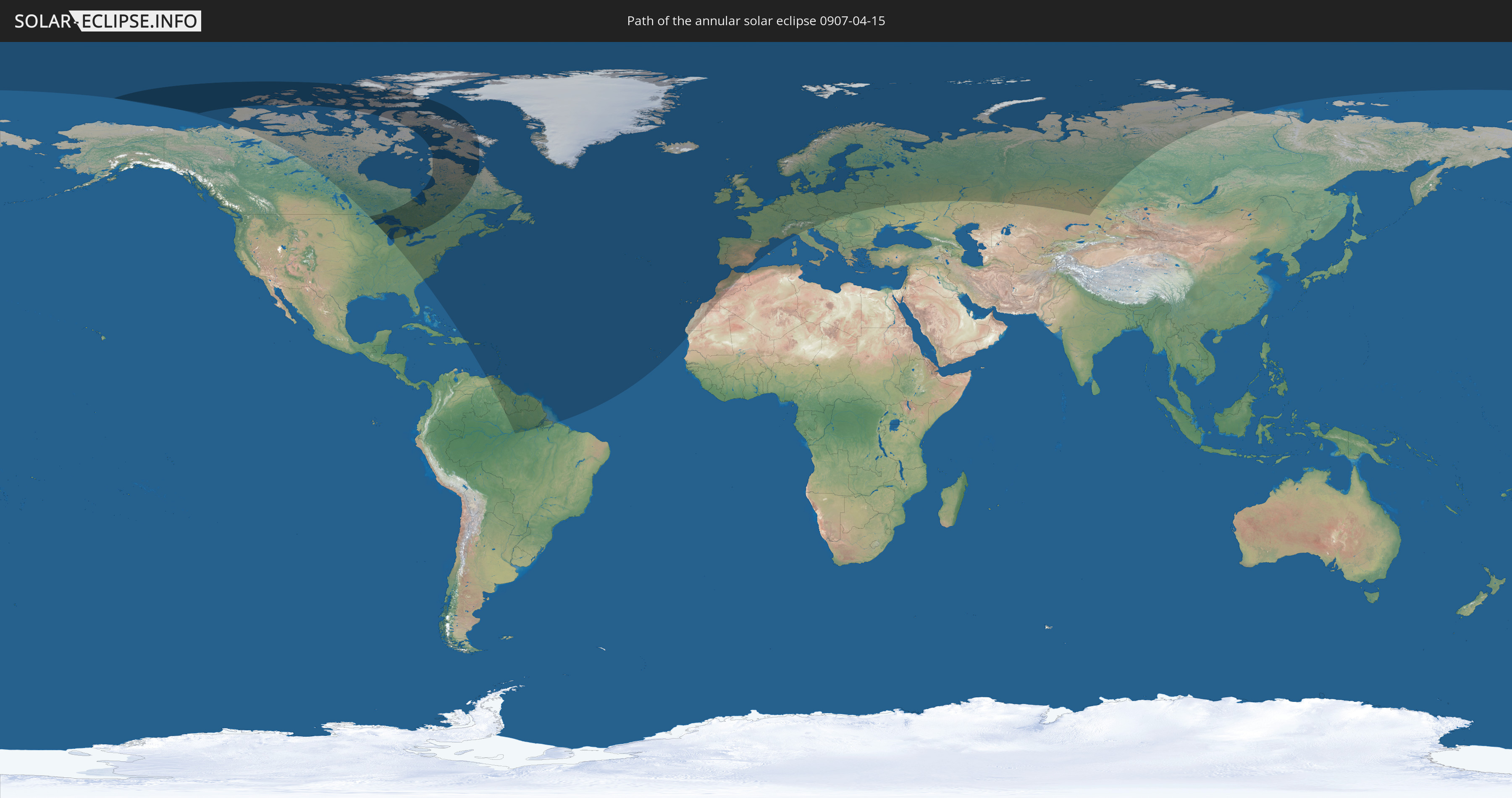
Annular solar eclipse of 04/15/0907
| Day of week: | Friday |
| Maximum duration of eclipse: | 03m04s |
| Maximum width of eclipse path: | 557 km |
| Saros cycle: | 111 |
| Coverage: | 95.5% |
| Magnitude: | 0.955 |
| Gamma: | 0.9549 |
Wo kann man die Sonnenfinsternis vom 04/15/0907 sehen?
Die Sonnenfinsternis am 04/15/0907 kann man in 70 Ländern als partielle Sonnenfinsternis beobachten.
Der Finsternispfad verläuft durch 2 Länder. Nur in diesen Ländern ist sie als annular Sonnenfinsternis zu sehen.
In den folgenden Ländern ist die Sonnenfinsternis annular zu sehen
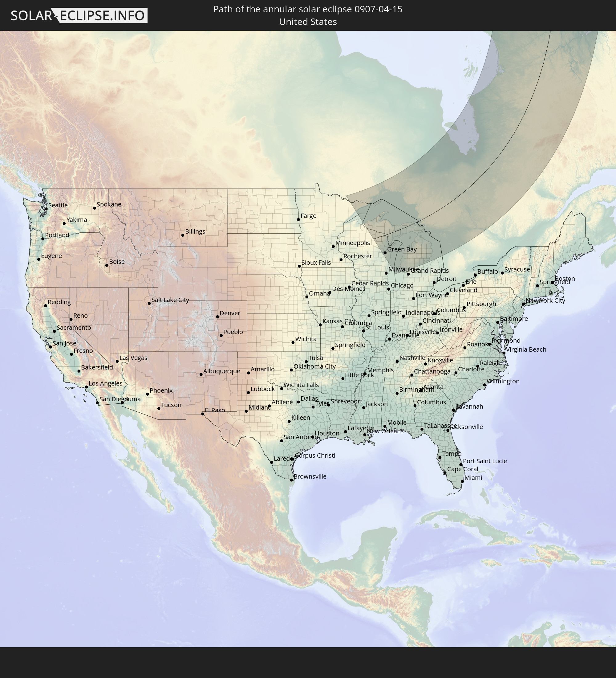 United States
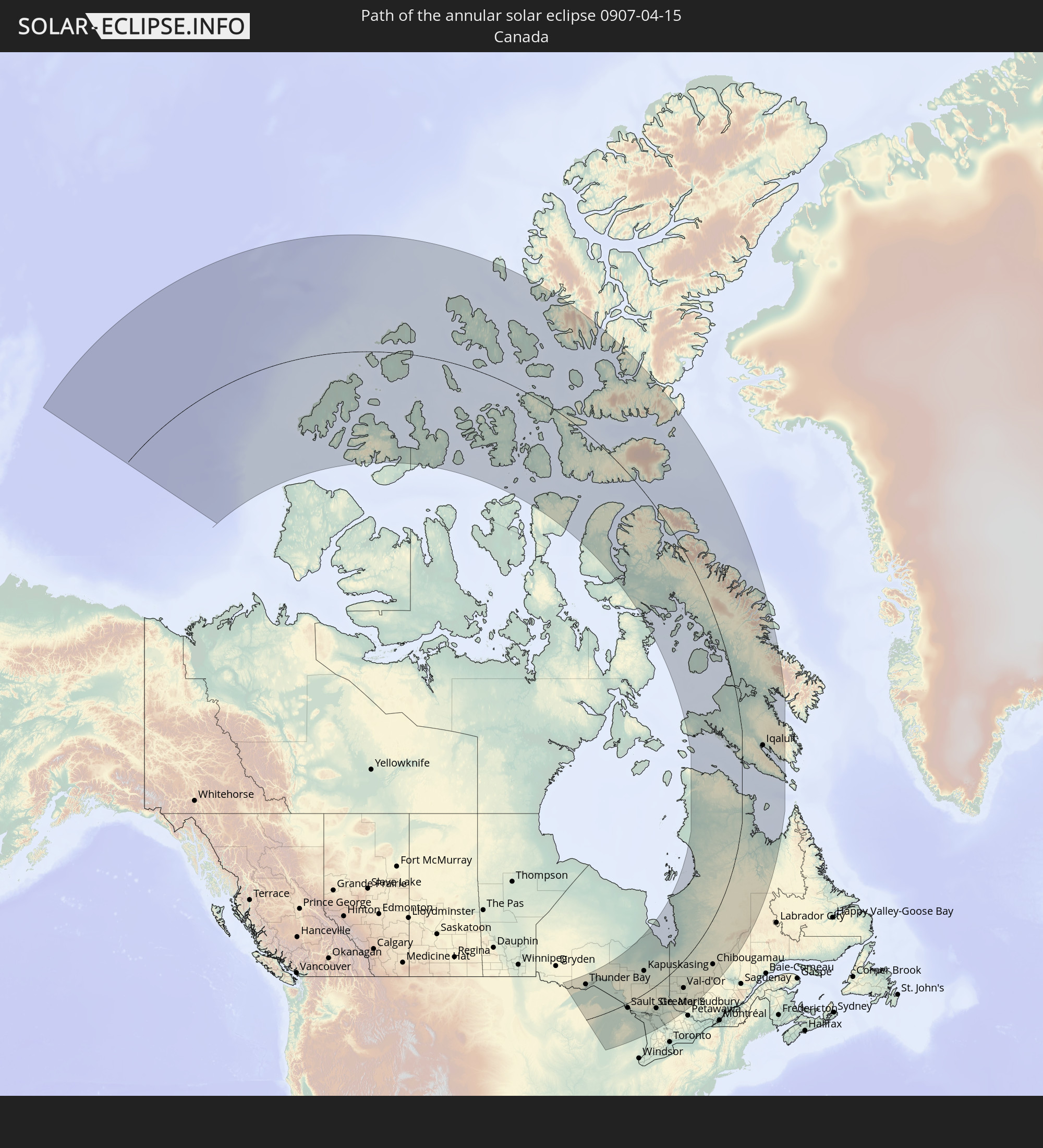 Canada
In den folgenden Ländern ist die Sonnenfinsternis partiell zu sehen
 Russia
 United States
 Canada
 Greenland
 Brazil
 Venezuela
 Dominican Republic
 Puerto Rico
 United States Virgin Islands
 Bermuda
 British Virgin Islands
 Anguilla
 Collectivity of Saint Martin
 Saint Barthélemy
 Saint Kitts and Nevis
 Antigua and Barbuda
 Montserrat
 Trinidad and Tobago
 Guadeloupe
 Grenada
 Dominica
 Saint Vincent and the Grenadines
 Guyana
 Martinique
 Saint Lucia
 Barbados
 Suriname
 Saint Pierre and Miquelon
 French Guiana
 Portugal
 Cabo Verde
 Iceland
 Spain
Spain
 Mauritania
 Morocco
 Republic of Ireland
 Svalbard and Jan Mayen
 United Kingdom
 Faroe Islands
 Gibraltar
 France
 Isle of Man
 Guernsey
 Jersey
 Andorra
 Belgium
 Netherlands
 Norway
 Luxembourg
 Germany
 Switzerland
 Italy
Italy
 Monaco
 Denmark
 Liechtenstein
 Austria
 Sweden
 Czechia
 Slovenia
 Poland
 Hungary
 Slovakia
 Åland Islands
 Finland
 Lithuania
 Latvia
 Estonia
 Ukraine
 Belarus
 Kazakhstan
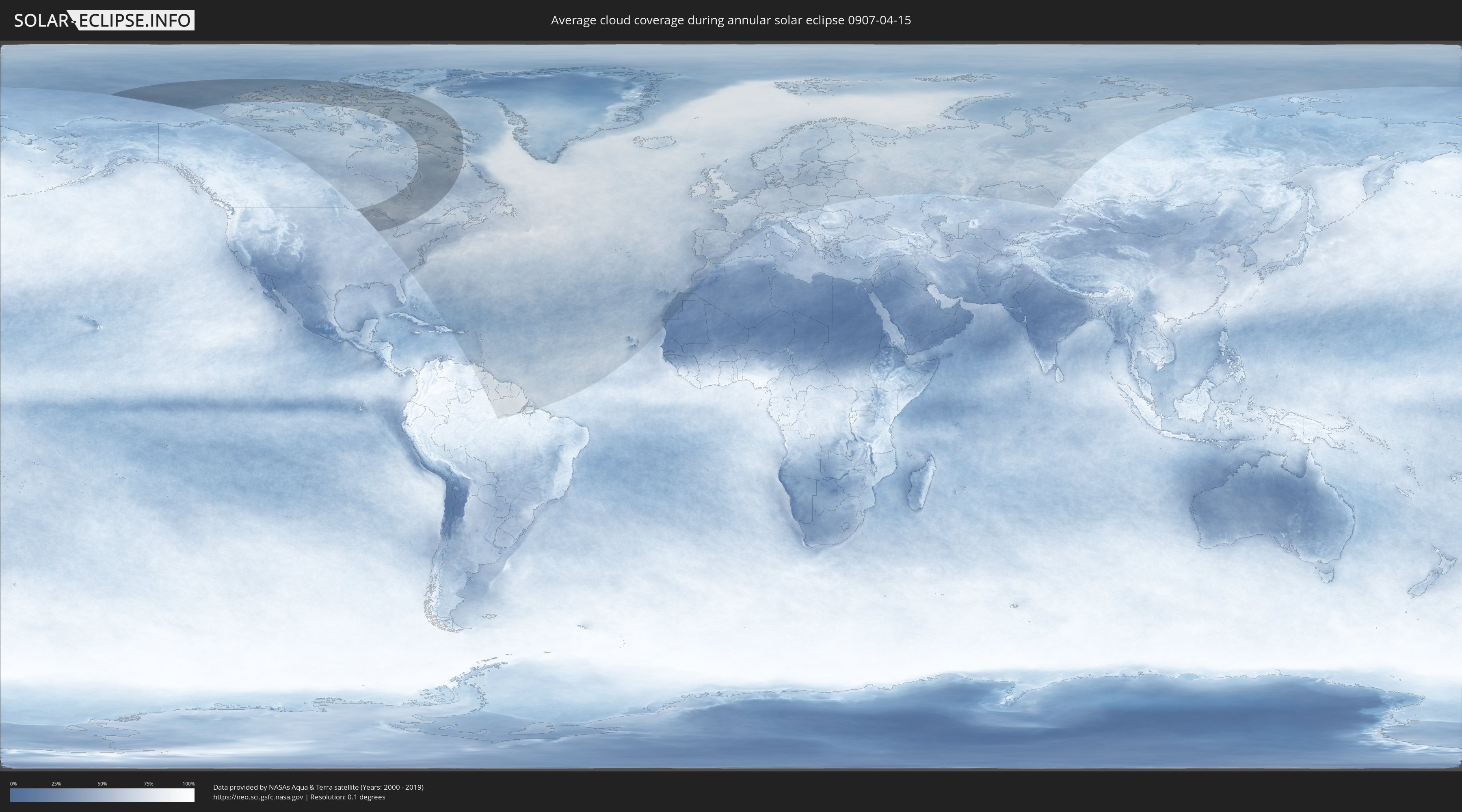
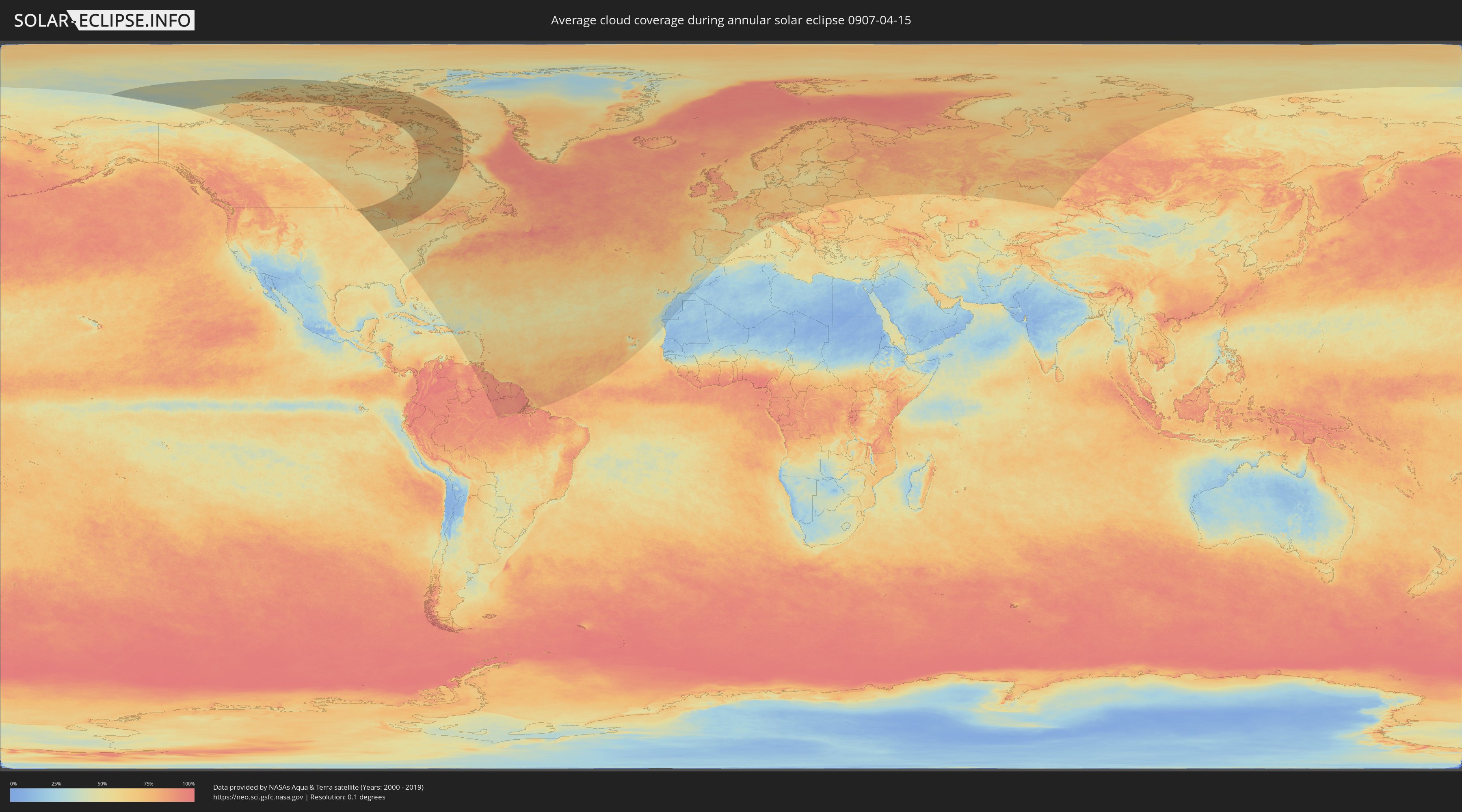
How will be the weather during the annular solar eclipse on 04/15/0907?
Where is the best place to see the annular solar eclipse of 04/15/0907?
The following maps show the average cloud coverage for the day of the annular solar eclipse.
With the help of these maps, it is possible to find the place along the eclipse path, which has the best
chance of a cloudless sky.
Nevertheless, you should consider local circumstances and inform about the weather of your chosen
observation site.
The data is provided by NASAs satellites
AQUA and TERRA.
The cloud maps are averaged over a period of 19 years (2000 - 2019).
Detailed country maps
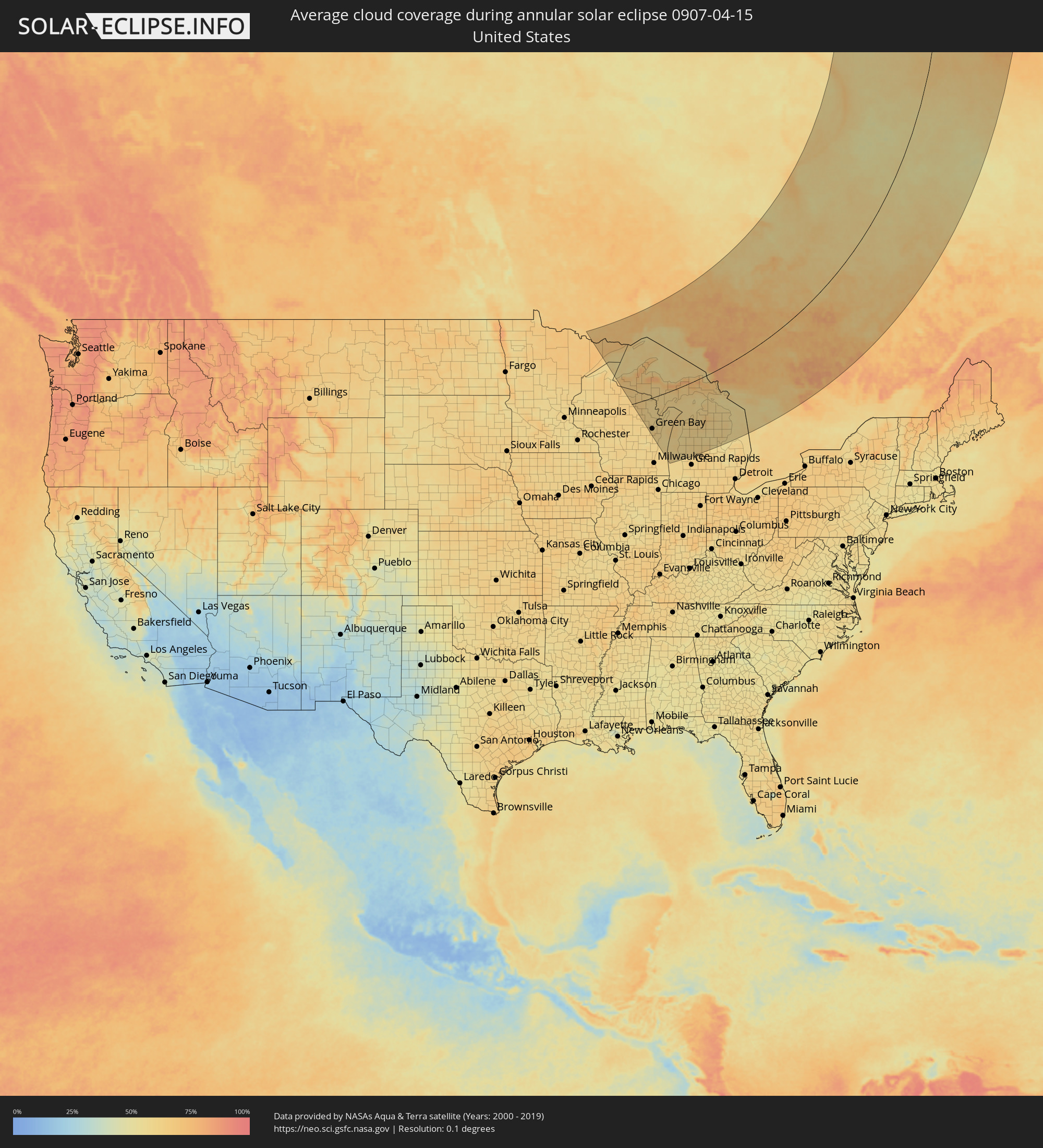 United States
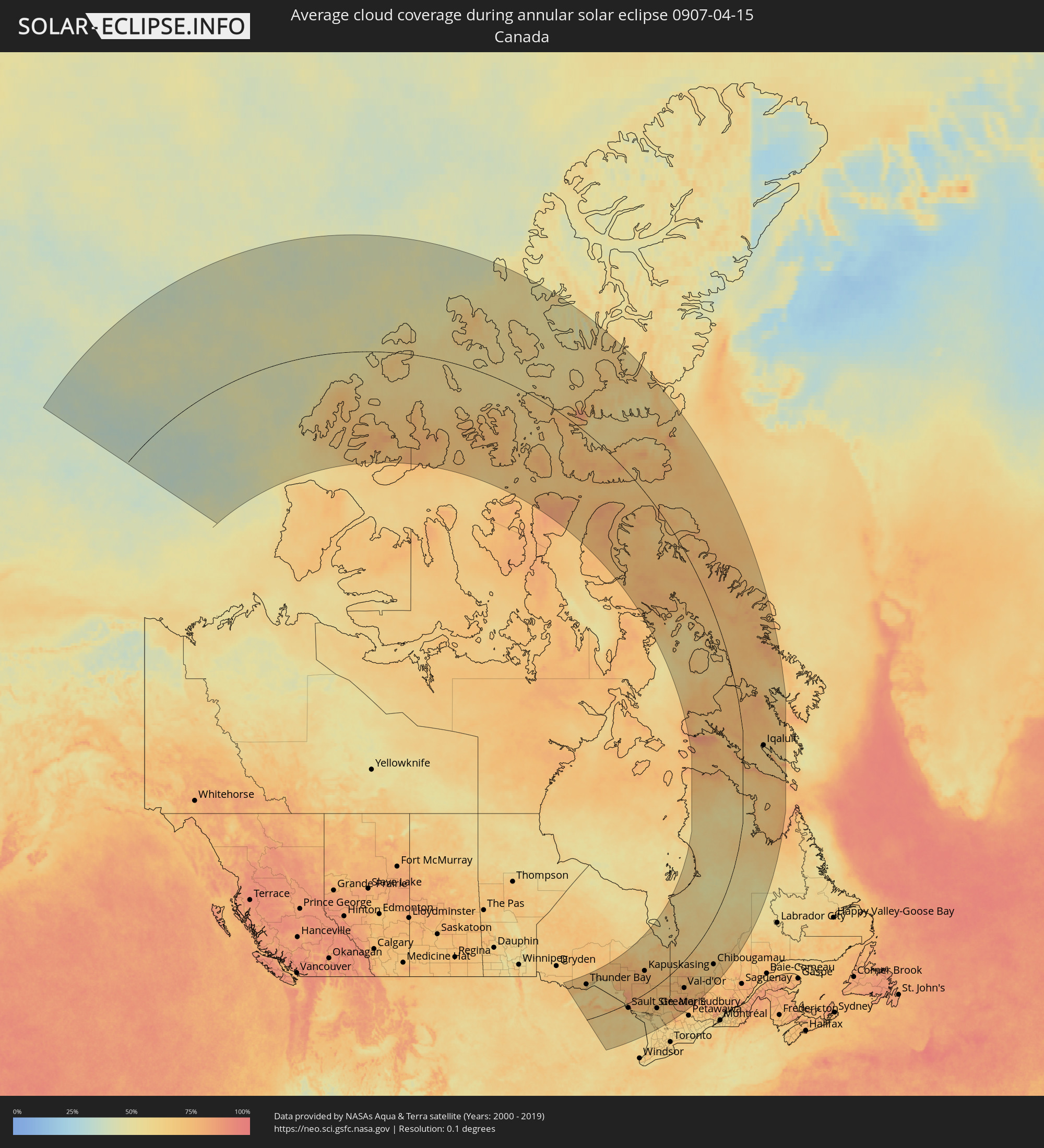 Canada
Cities inside the path of the eclipse
The following table shows all locations with a population of more than 5,000 inside the eclipse path. Cities which have more than 100,000 inhabitants are marked bold. A click at the locations opens a detailed map.
| City | Type | Eclipse duration | Local time of max. eclipse | Distance to central line | Ø Cloud coverage |
|
Thunder Bay, Ontario
|
annular | - | 06:13:17 UTC-05:00 | 299 km | 69% |
|
Iron River, Michigan
|
annular | - | 05:09:07 UTC-06:00 | 43 km | 64% |
|
Houghton, Michigan
|
annular | - | 06:10:52 UTC-05:00 | 150 km | 74% |
|
Howard, Wisconsin
|
annular | - | 05:06:17 UTC-06:00 | 134 km | 61% |
|
Kingsford, Michigan
|
annular | - | 05:08:25 UTC-06:00 | 2 km | 60% |
|
Ashwaubenon, Wisconsin
|
annular | - | 05:06:10 UTC-06:00 | 141 km | 61% |
|
Iron Mountain, Michigan
|
annular | - | 05:08:27 UTC-06:00 | 1 km | 60% |
|
De Pere, Wisconsin
|
annular | - | 05:06:06 UTC-06:00 | 145 km | 62% |
|
Suamico, Wisconsin
|
annular | - | 05:06:25 UTC-06:00 | 126 km | 61% |
|
Green Bay, Wisconsin
|
annular | - | 05:06:13 UTC-06:00 | 138 km | 63% |
|
Allouez, Wisconsin
|
annular | - | 05:06:08 UTC-06:00 | 143 km | 63% |
|
Bellevue, Wisconsin
|
annular | - | 05:06:03 UTC-06:00 | 149 km | 65% |
|
Ishpeming, Michigan
|
annular | - | 06:09:29 UTC-05:00 | 60 km | 65% |
|
Manitowoc, Wisconsin
|
annular | - | 05:05:21 UTC-06:00 | 193 km | 58% |
|
Marinette, Wisconsin
|
annular | - | 05:07:04 UTC-06:00 | 86 km | 60% |
|
Menominee, Michigan
|
annular | - | 05:07:05 UTC-06:00 | 86 km | 60% |
|
Two Rivers, Wisconsin
|
annular | - | 05:05:26 UTC-06:00 | 188 km | 59% |
|
Marquette, Michigan
|
annular | - | 06:09:30 UTC-05:00 | 59 km | 71% |
|
Sturgeon Bay, Wisconsin
|
annular | - | 05:06:32 UTC-06:00 | 121 km | 60% |
|
Escanaba, Michigan
|
annular | - | 06:08:00 UTC-05:00 | 33 km | 61% |
|
Ludington, Michigan
|
annular | - | 06:04:44 UTC-05:00 | 237 km | 60% |
|
Manistee, Michigan
|
annular | - | 06:05:11 UTC-05:00 | 210 km | 56% |
|
Muskegon, Michigan
|
annular | - | 06:03:26 UTC-05:00 | 318 km | 57% |
|
Traverse City, Michigan
|
annular | - | 06:05:51 UTC-05:00 | 176 km | 62% |
|
Big Rapids, Michigan
|
annular | - | 06:03:58 UTC-05:00 | 291 km | 60% |
|
Cadillac, Michigan
|
annular | - | 06:04:54 UTC-05:00 | 235 km | 59% |
|
Petoskey, Michigan
|
annular | - | 06:06:44 UTC-05:00 | 133 km | 60% |
|
Mount Pleasant, Michigan
|
annular | - | 06:03:35 UTC-05:00 | 322 km | 65% |
|
Sault Ste. Marie, Michigan
|
annular | - | 06:08:33 UTC-05:00 | 40 km | 68% |
|
Sault Ste. Marie, Ontario
|
annular | - | 06:08:35 UTC-05:00 | 38 km | 68% |
|
Alpena, Michigan
|
annular | - | 06:05:46 UTC-05:00 | 215 km | 57% |
|
Elliot Lake, Ontario
|
annular | - | 06:07:56 UTC-05:00 | 113 km | 72% |
|
Kapuskasing, Ontario
|
annular | - | 06:13:27 UTC-05:00 | 162 km | 76% |
|
Timmins, Ontario
|
annular | - | 06:11:29 UTC-05:00 | 29 km | 75% |
|
Rayside-Balfour, Ontario
|
annular | - | 06:08:02 UTC-05:00 | 147 km | 67% |
|
Greater Sudbury, Ontario
|
annular | - | 06:07:47 UTC-05:00 | 167 km | 70% |
|
Kirkland Lake, Ontario
|
annular | - | 06:10:40 UTC-05:00 | 58 km | 74% |
|
Parry Sound, Ontario
|
annular | - | 06:05:30 UTC-05:00 | 314 km | 65% |
|
Temiskaming Shores, Ontario
|
annular | - | 06:09:24 UTC-05:00 | 130 km | 73% |
|
North Bay, Ontario
|
annular | - | 06:07:10 UTC-05:00 | 248 km | 63% |
|
La Sarre, Quebec
|
annular | - | 06:11:46 UTC-05:00 | 41 km | 68% |
|
Rouyn-Noranda, Quebec
|
annular | - | 06:10:41 UTC-05:00 | 97 km | 75% |
|
Amos, Quebec
|
annular | - | 06:11:11 UTC-05:00 | 113 km | 75% |
|
Val-d'Or, Quebec
|
annular | - | 06:10:15 UTC-05:00 | 168 km | 77% |
|
Chibougamau, Quebec
|
annular | - | 06:13:29 UTC-05:00 | 206 km | 64% |
|
Iqaluit, Nunavut
|
annular | - | 06:42:02 UTC-05:00 | 147 km | 62% |