Total solar eclipse of 11/11/0923
| Day of week: | Thursday |
| Maximum duration of eclipse: | 04m01s |
| Maximum width of eclipse path: | 162 km |
| Saros cycle: | 96 |
| Coverage: | 100% |
| Magnitude: | 1.044 |
| Gamma: | 0.4377 |
Wo kann man die Sonnenfinsternis vom 11/11/0923 sehen?
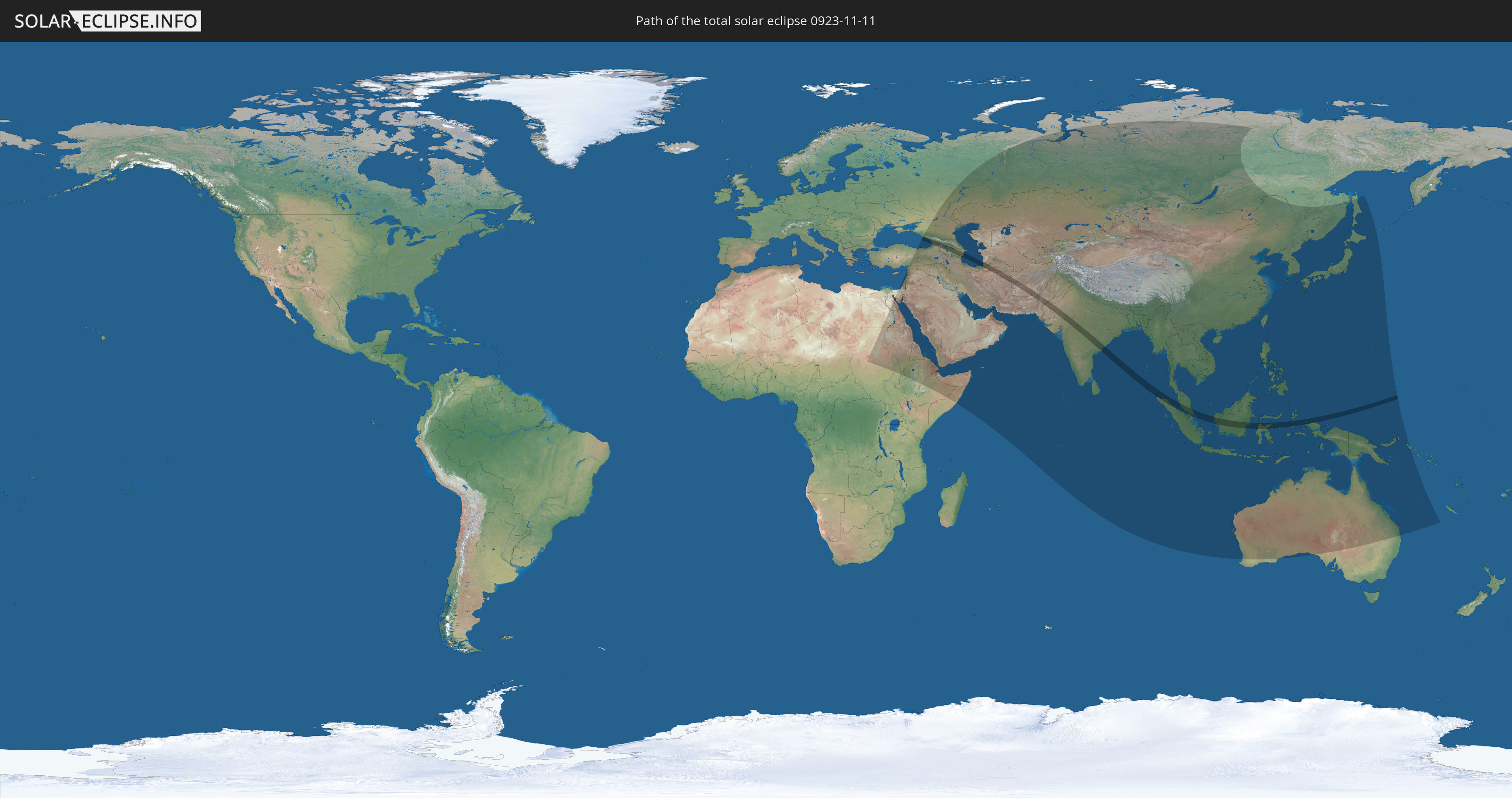
Die Sonnenfinsternis am 11/11/0923 kann man in 68 Ländern als partielle Sonnenfinsternis beobachten.
Der Finsternispfad verläuft durch 13 Länder. Nur in diesen Ländern ist sie als total Sonnenfinsternis zu sehen.
In den folgenden Ländern ist die Sonnenfinsternis total zu sehen
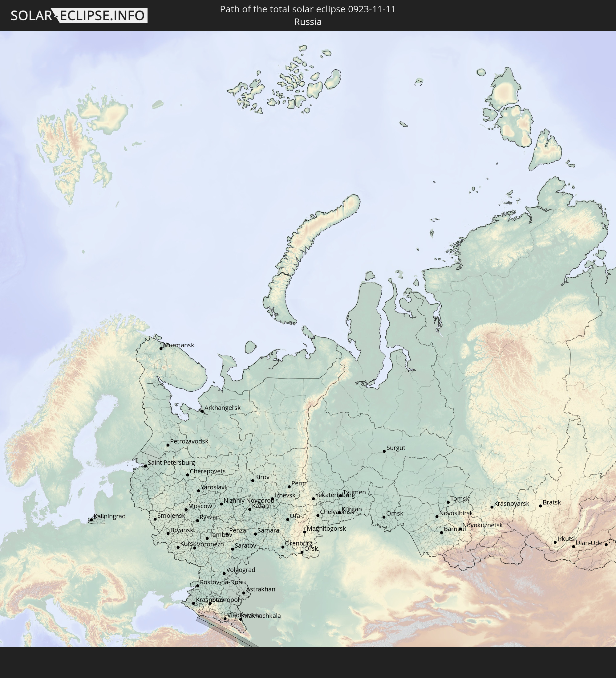 Russia
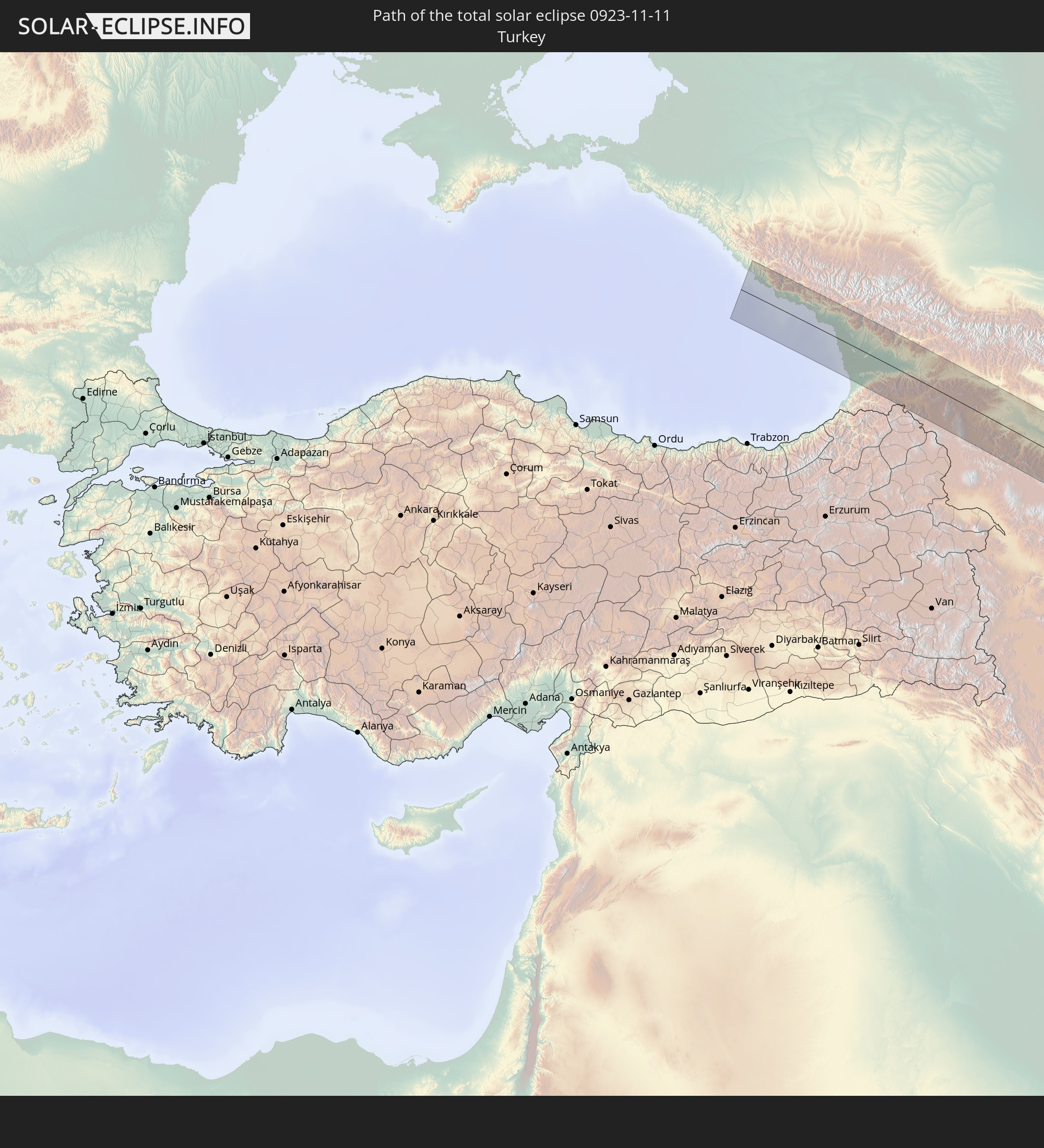 Turkey
 Georgia
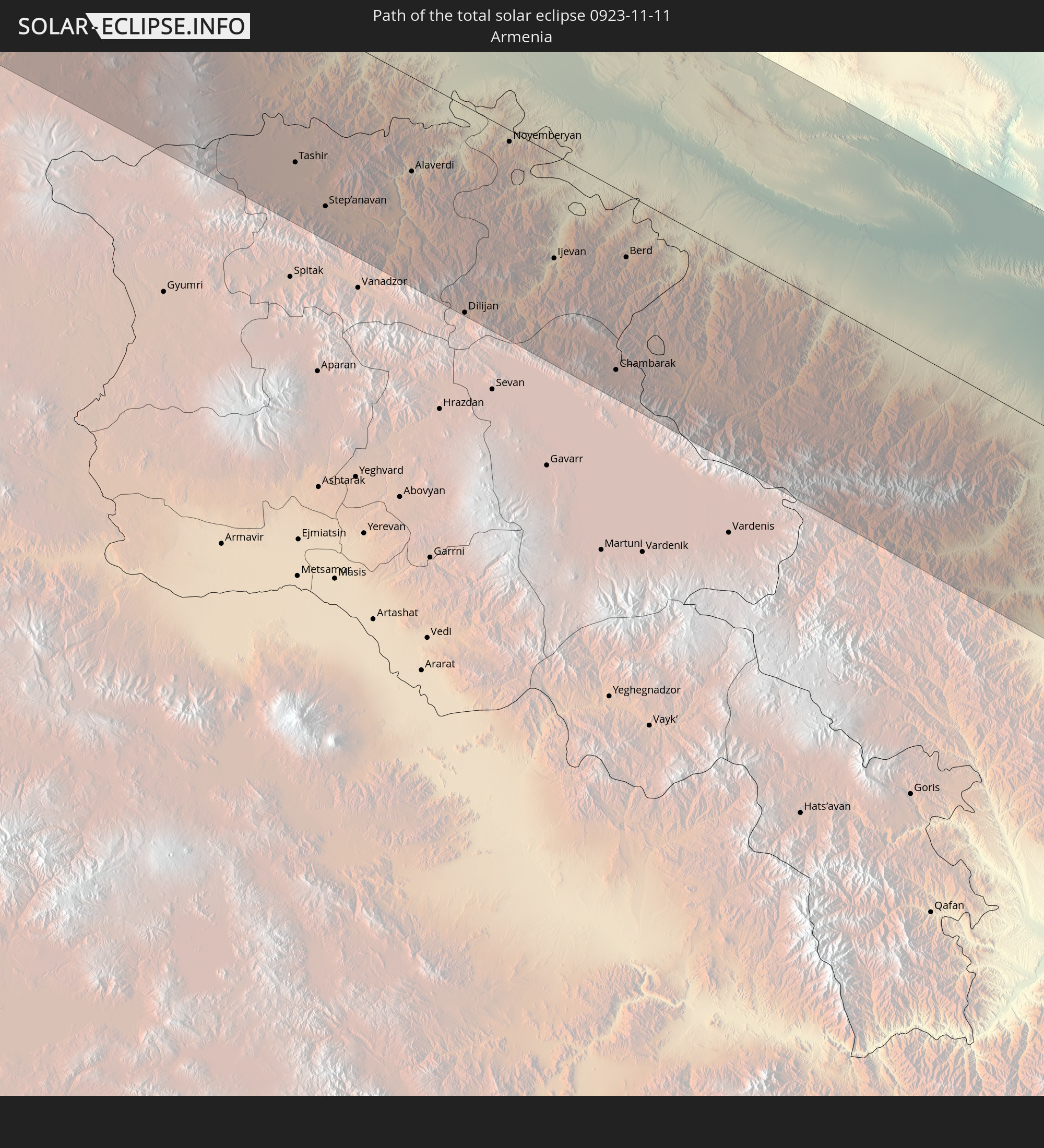 Armenia
 Iran
Iran
 Azerbaijan
 Turkmenistan
 Afghanistan
 Pakistan
 India
India
 Indonesia
 Malaysia
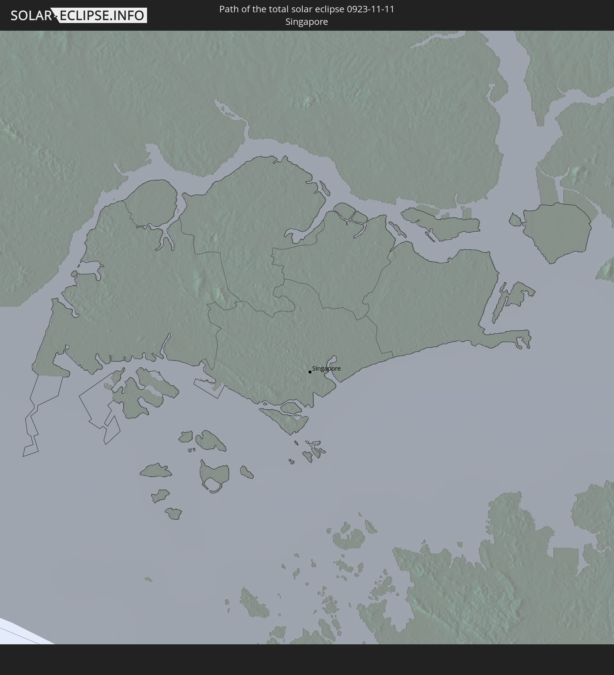 Singapore
In den folgenden Ländern ist die Sonnenfinsternis partiell zu sehen
 Russia
 Sudan
Sudan
 Egypt
Egypt
 Turkey
 Ethiopia
 State of Palestine
 Israel
 Saudi Arabia
 Jordan
 Lebanon
 Syria
Syria
 Eritrea
 Iraq
Iraq
 Georgia
 Somalia
 Djibouti
 Yemen
Yemen
 Armenia
 Iran
Iran
 Azerbaijan
 Kazakhstan
 Kuwait
 Bahrain
 Qatar
Qatar
 United Arab Emirates
 Oman
Oman
 Turkmenistan
 Uzbekistan
 Afghanistan
 Pakistan
 Tajikistan
 India
India
 Kyrgyzstan
 British Indian Ocean Territory
 Maldives
 China
China
 Sri Lanka
 Nepal
Nepal
 Mongolia
 Bangladesh
 Bhutan
 Myanmar
 Indonesia
 Cocos Islands
 Thailand
 Malaysia
 Laos
Laos
 Vietnam
 Cambodia
 Singapore
 Christmas Island
 Australia
 Macau
Macau
 Hong Kong
 Brunei
 Taiwan
 Philippines
 Japan
Japan
 East Timor
 North Korea
 South Korea
 Palau
Palau
 Federated States of Micronesia
 Papua New Guinea
 Guam
Guam
 Northern Mariana Islands
 Solomon Islands
 New Caledonia
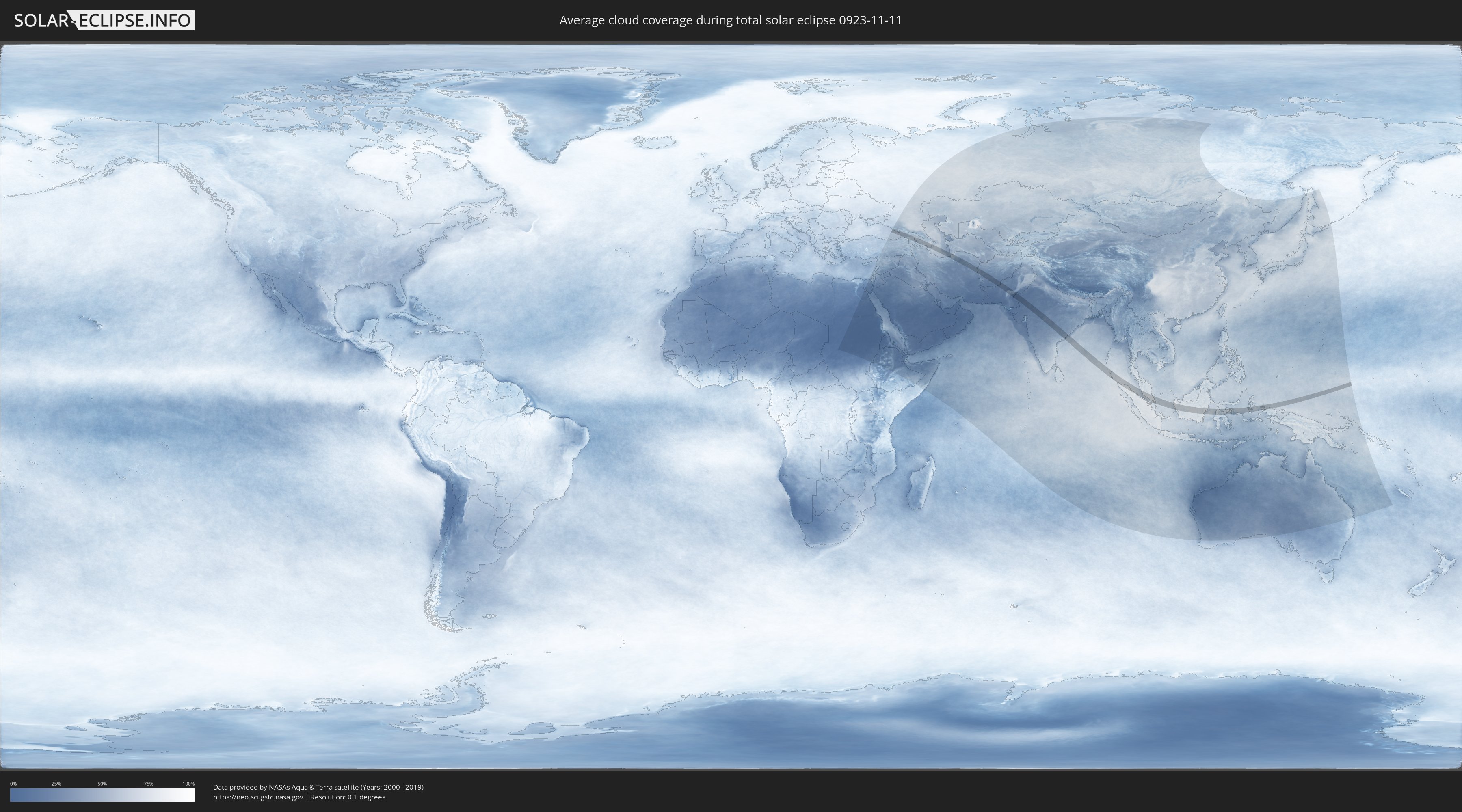
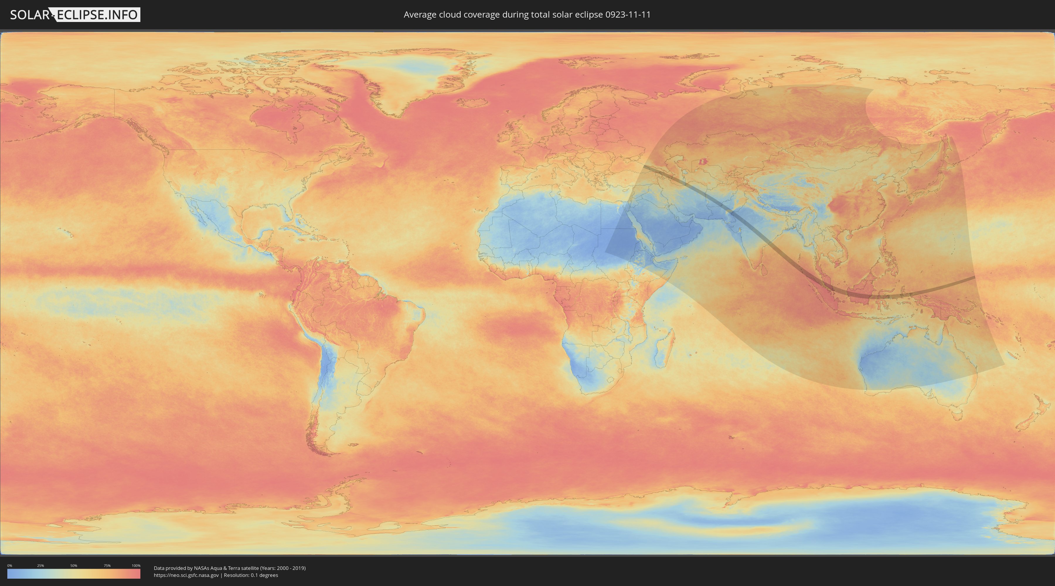
How will be the weather during the total solar eclipse on 11/11/0923?
Where is the best place to see the total solar eclipse of 11/11/0923?
The following maps show the average cloud coverage for the day of the total solar eclipse.
With the help of these maps, it is possible to find the place along the eclipse path, which has the best
chance of a cloudless sky.
Nevertheless, you should consider local circumstances and inform about the weather of your chosen
observation site.
The data is provided by NASAs satellites
AQUA and TERRA.
The cloud maps are averaged over a period of 19 years (2000 - 2019).
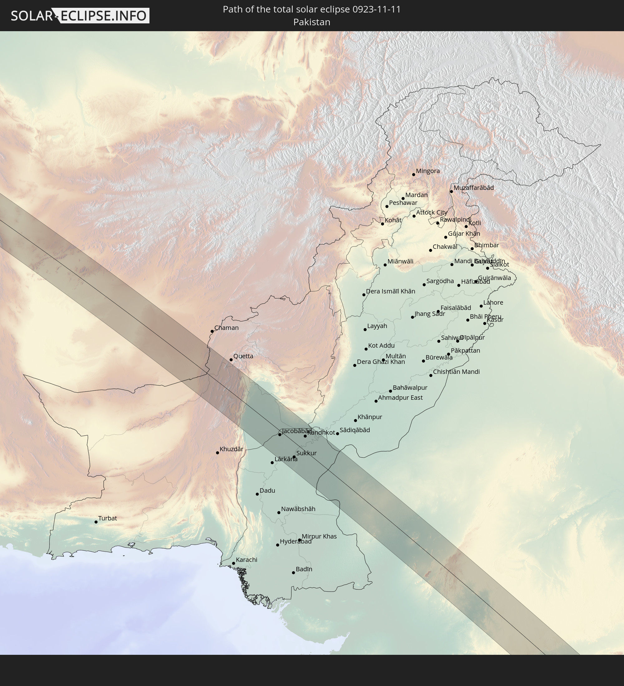
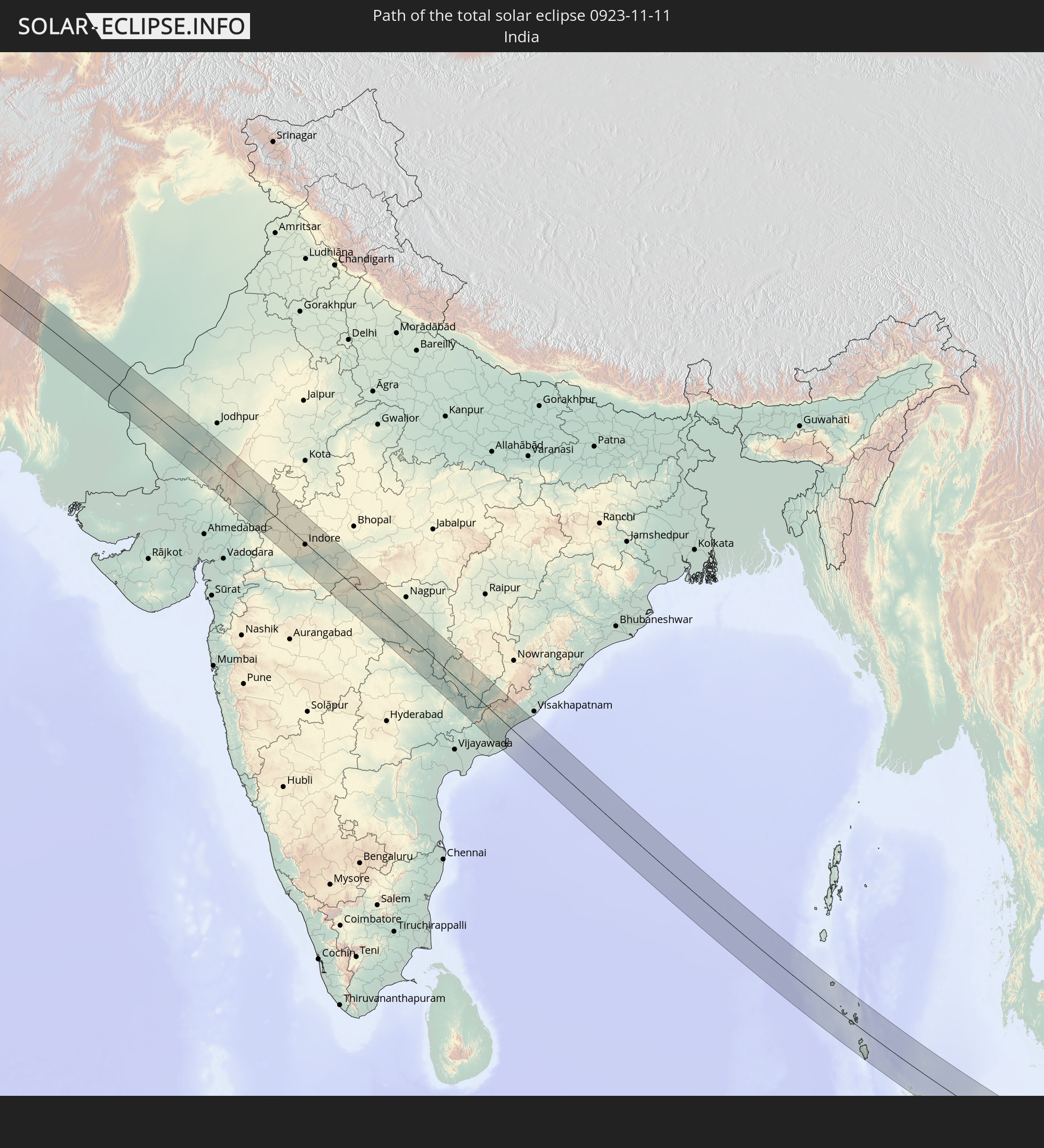
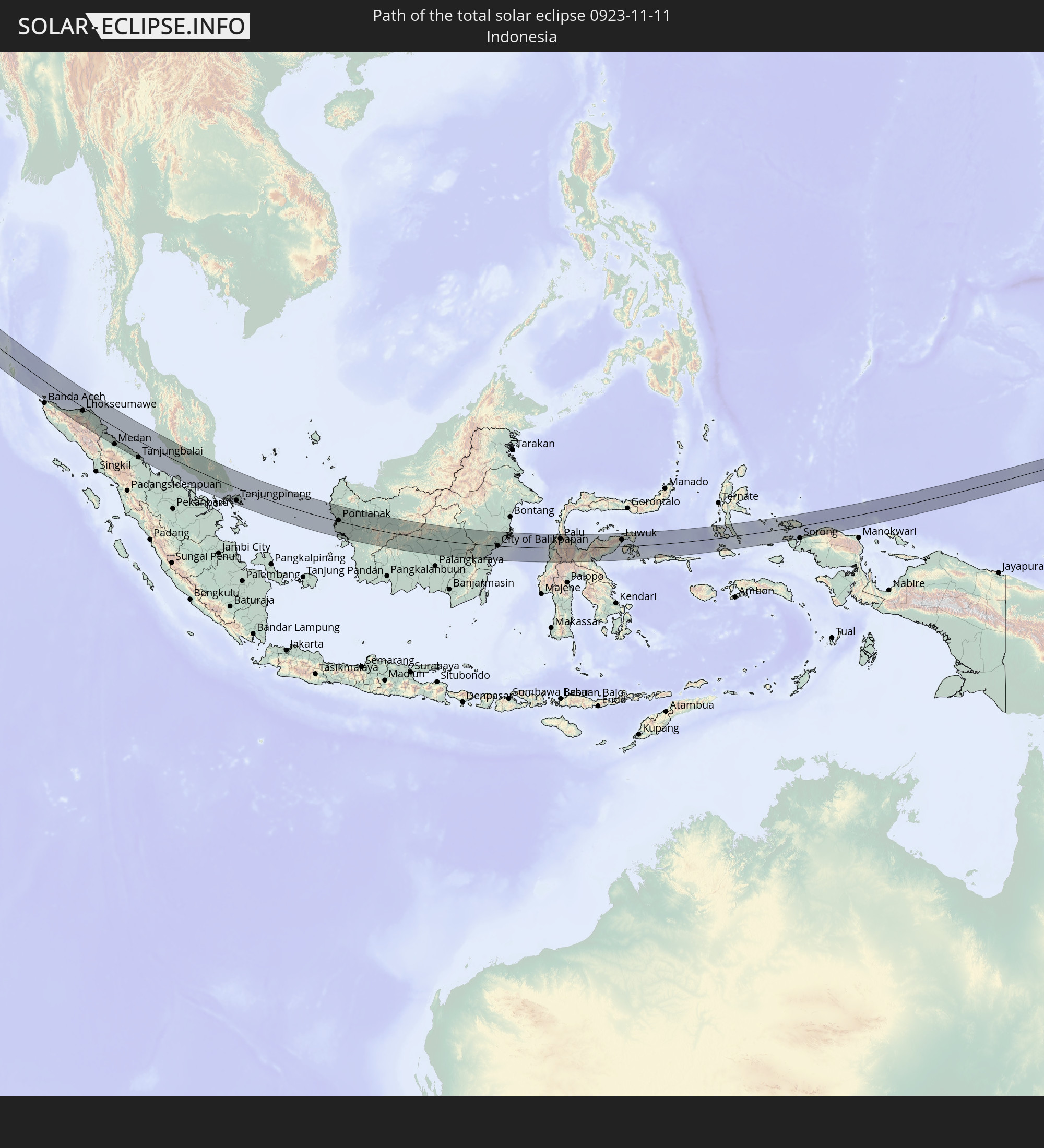
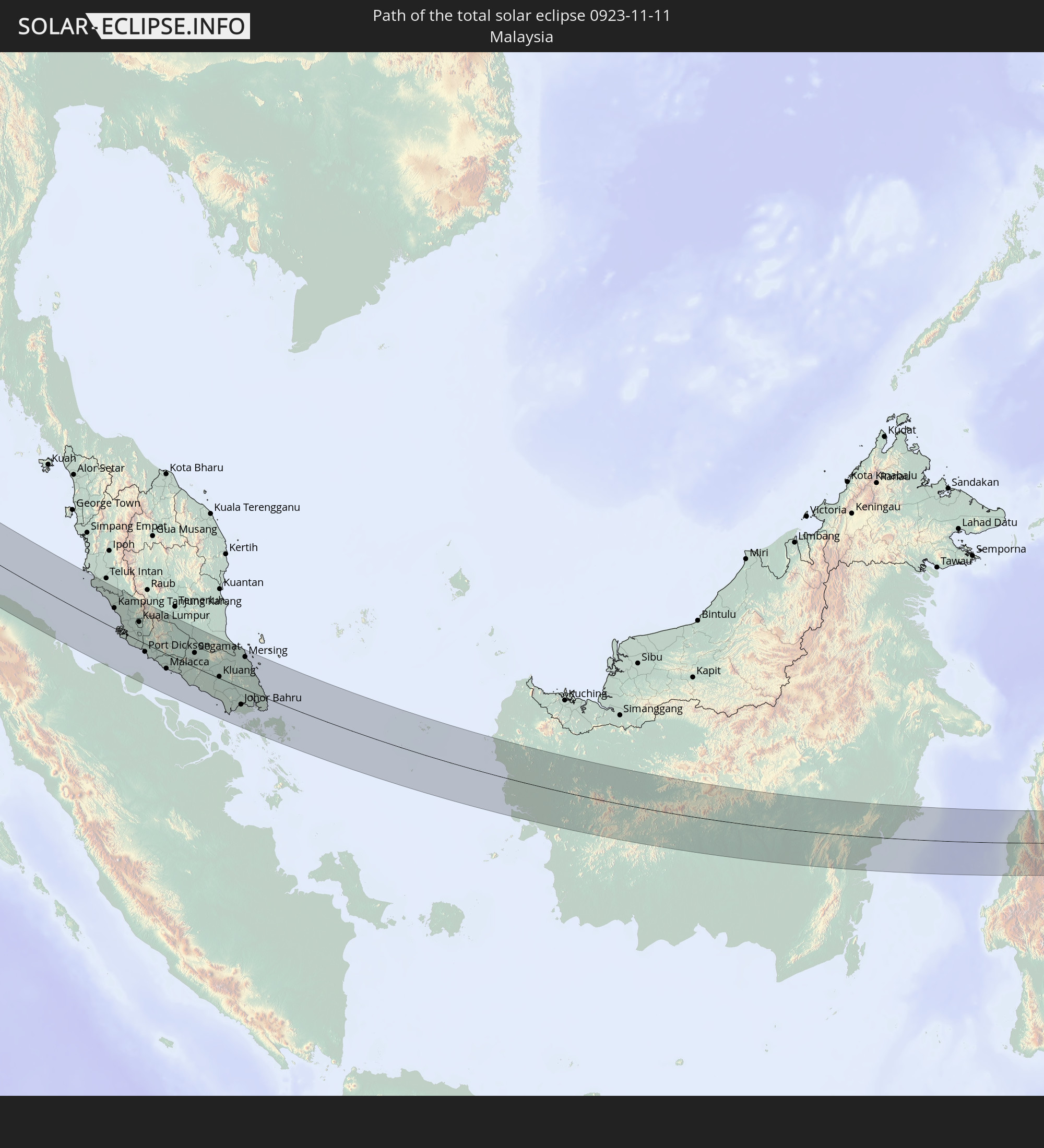
Detailed country maps
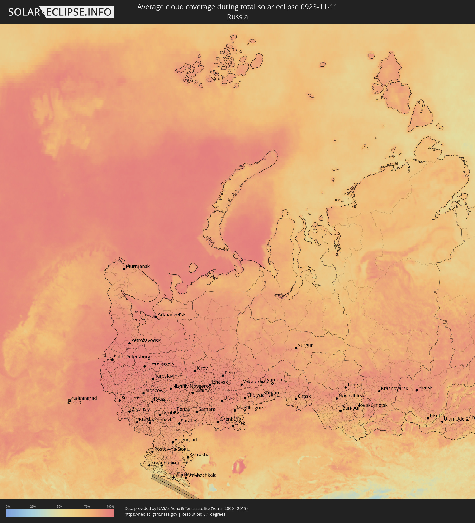 Russia
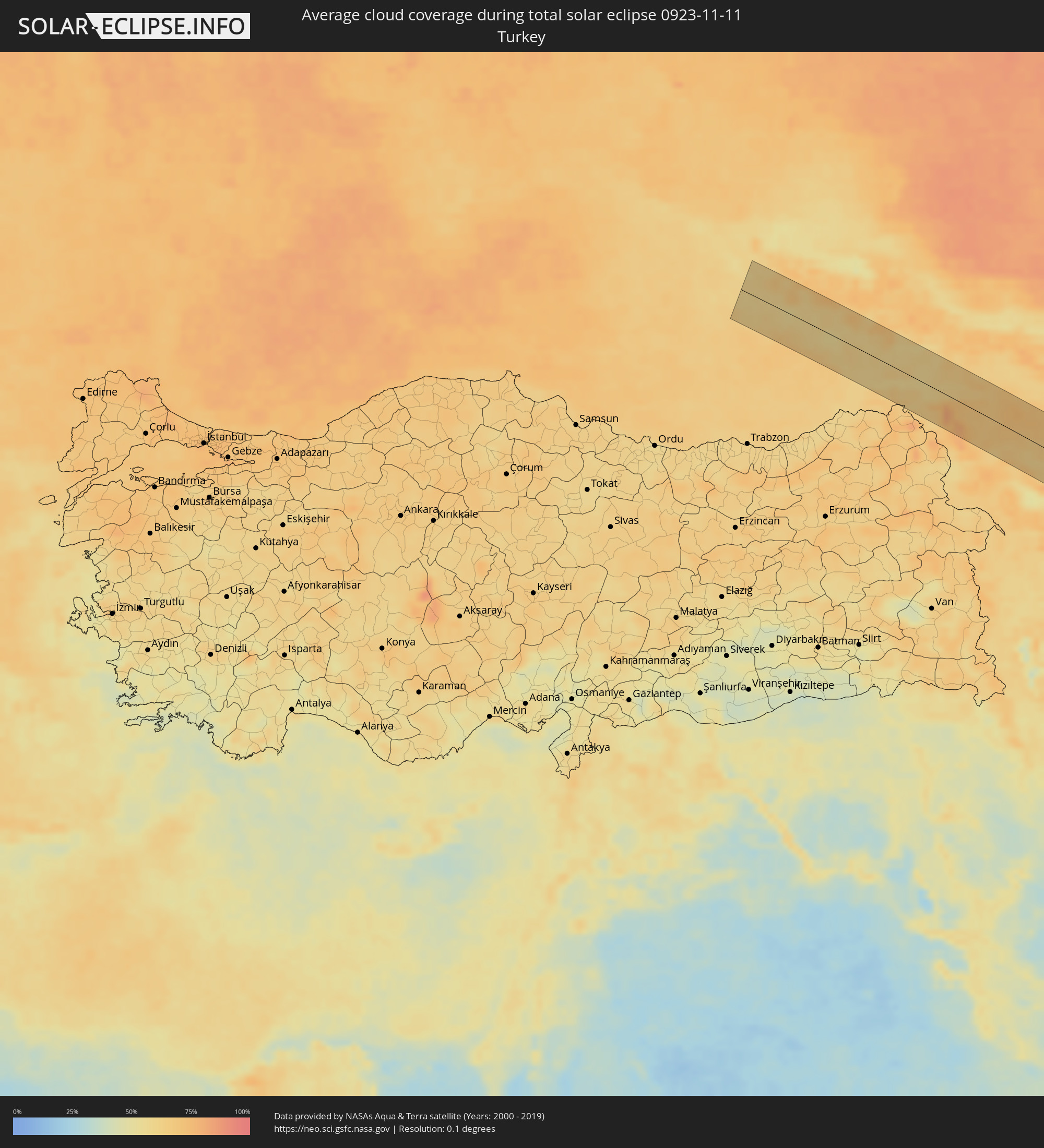 Turkey
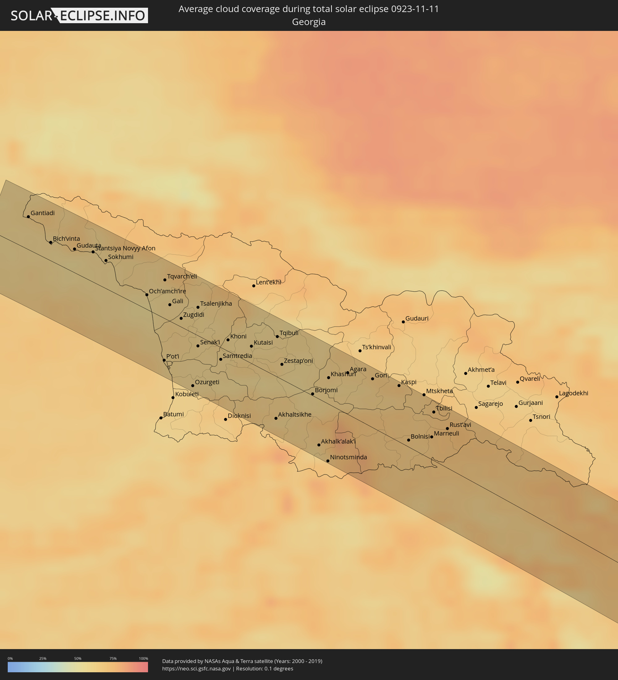 Georgia
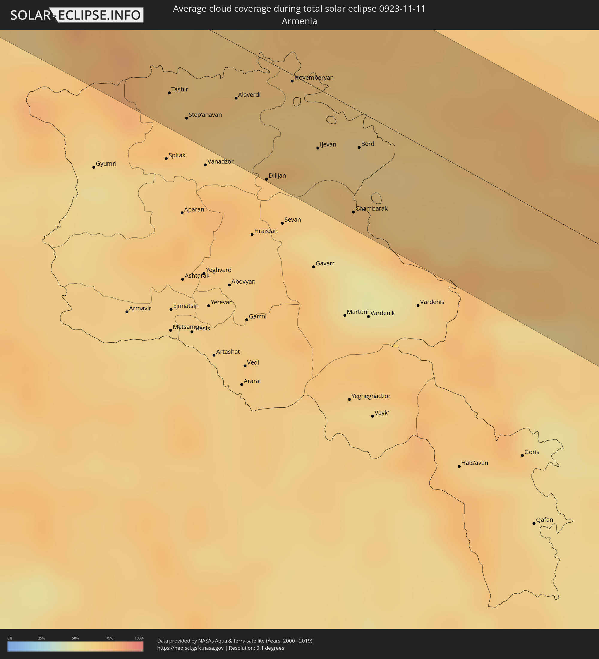 Armenia
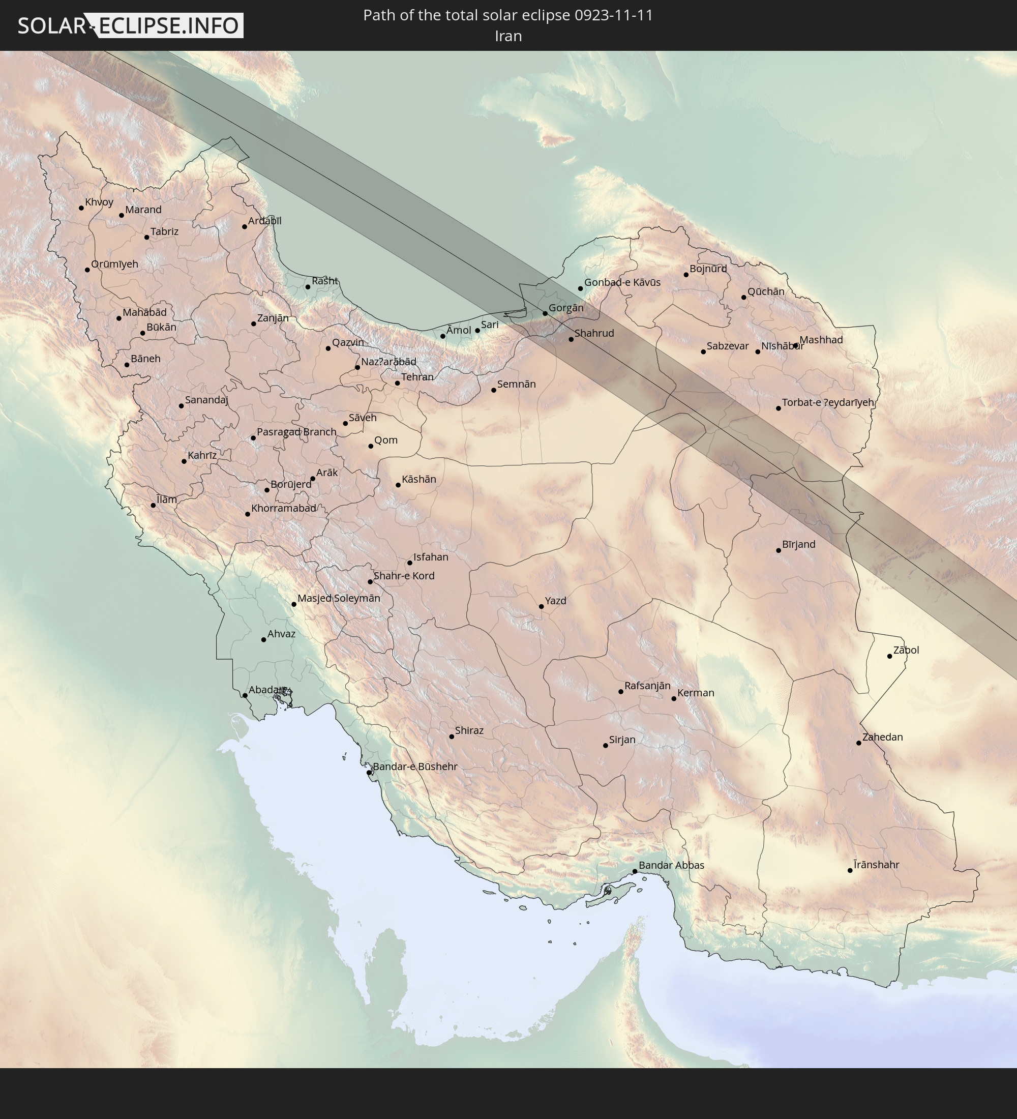
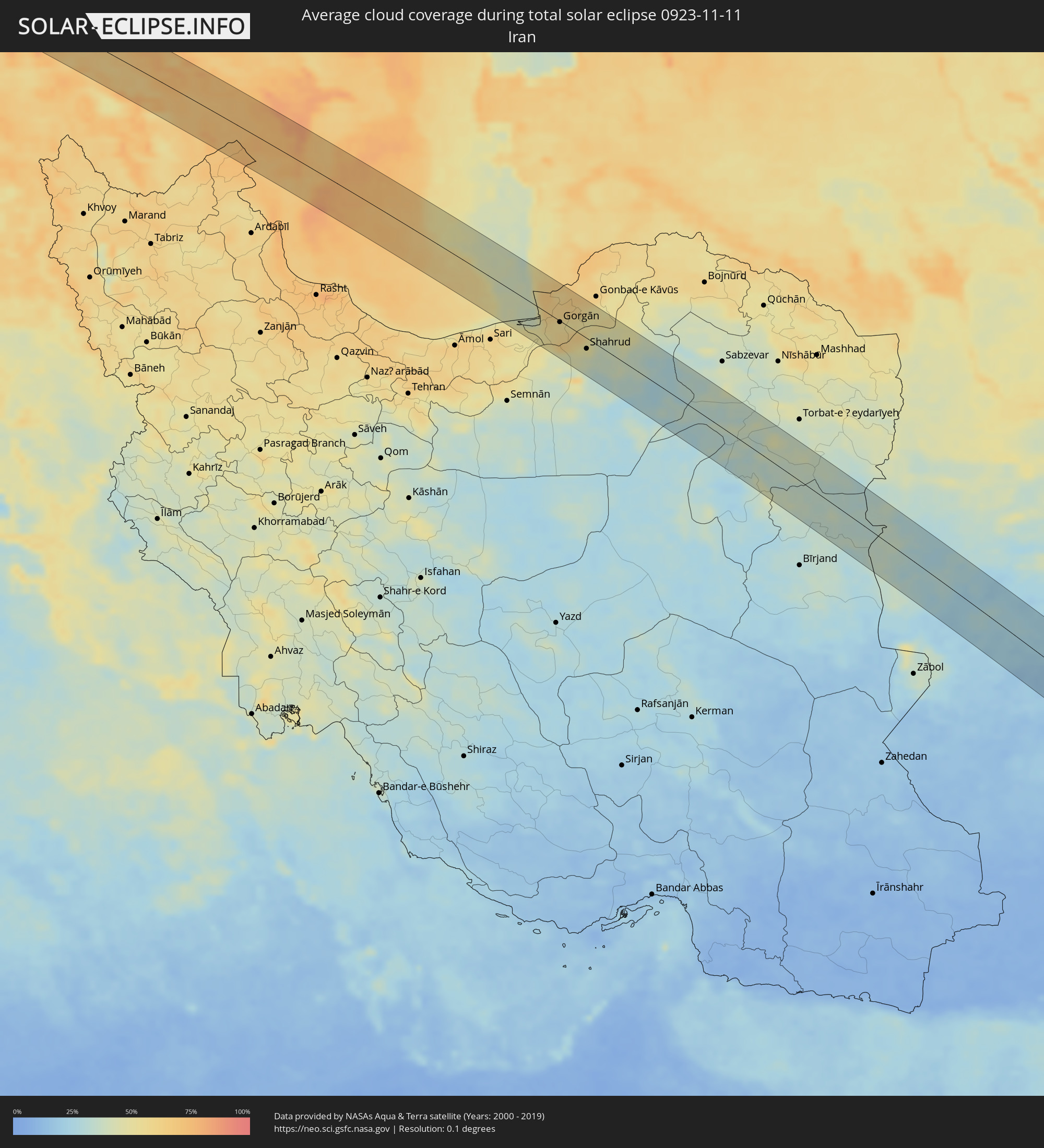 Iran
Iran
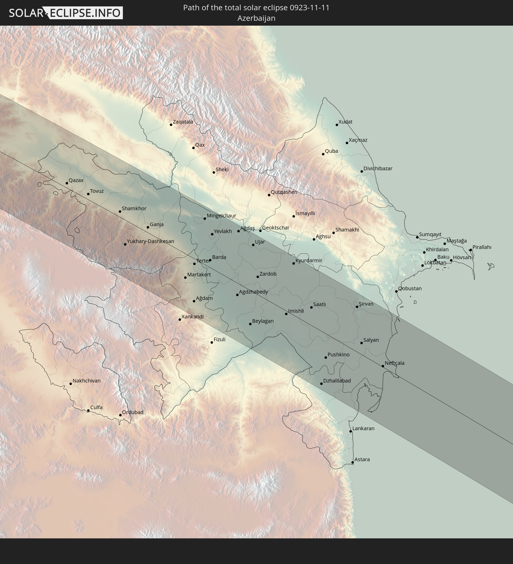
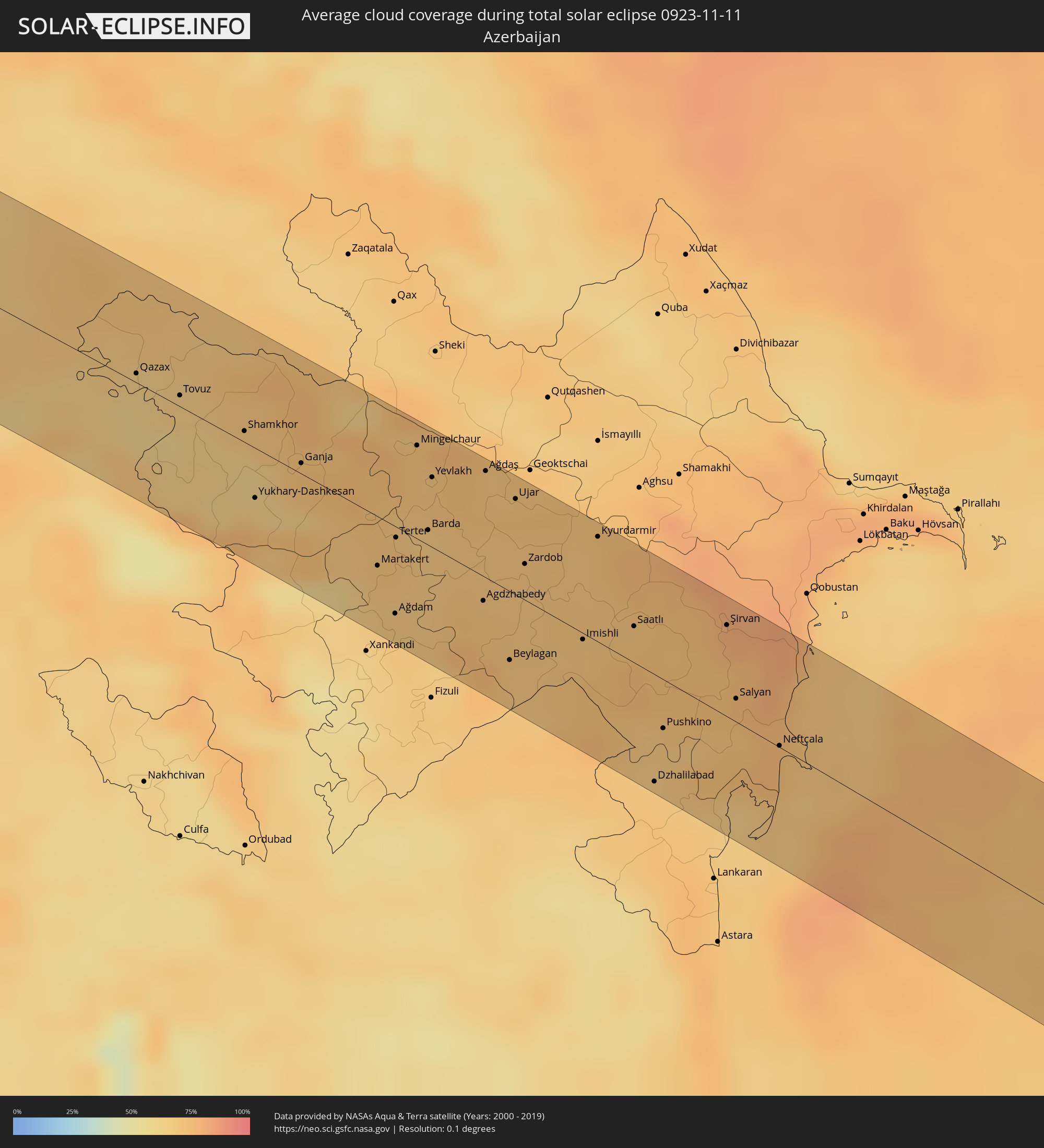 Azerbaijan
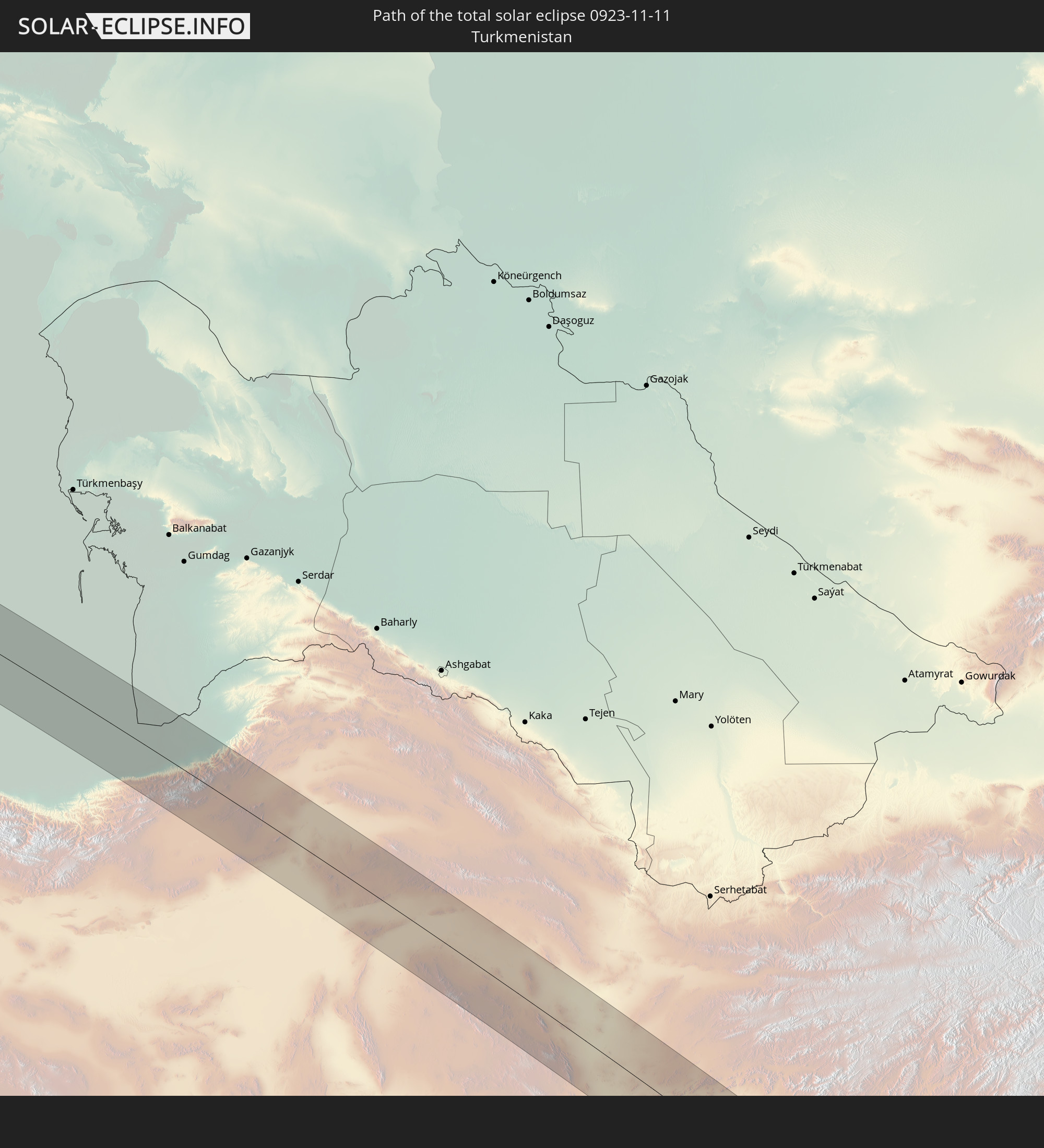
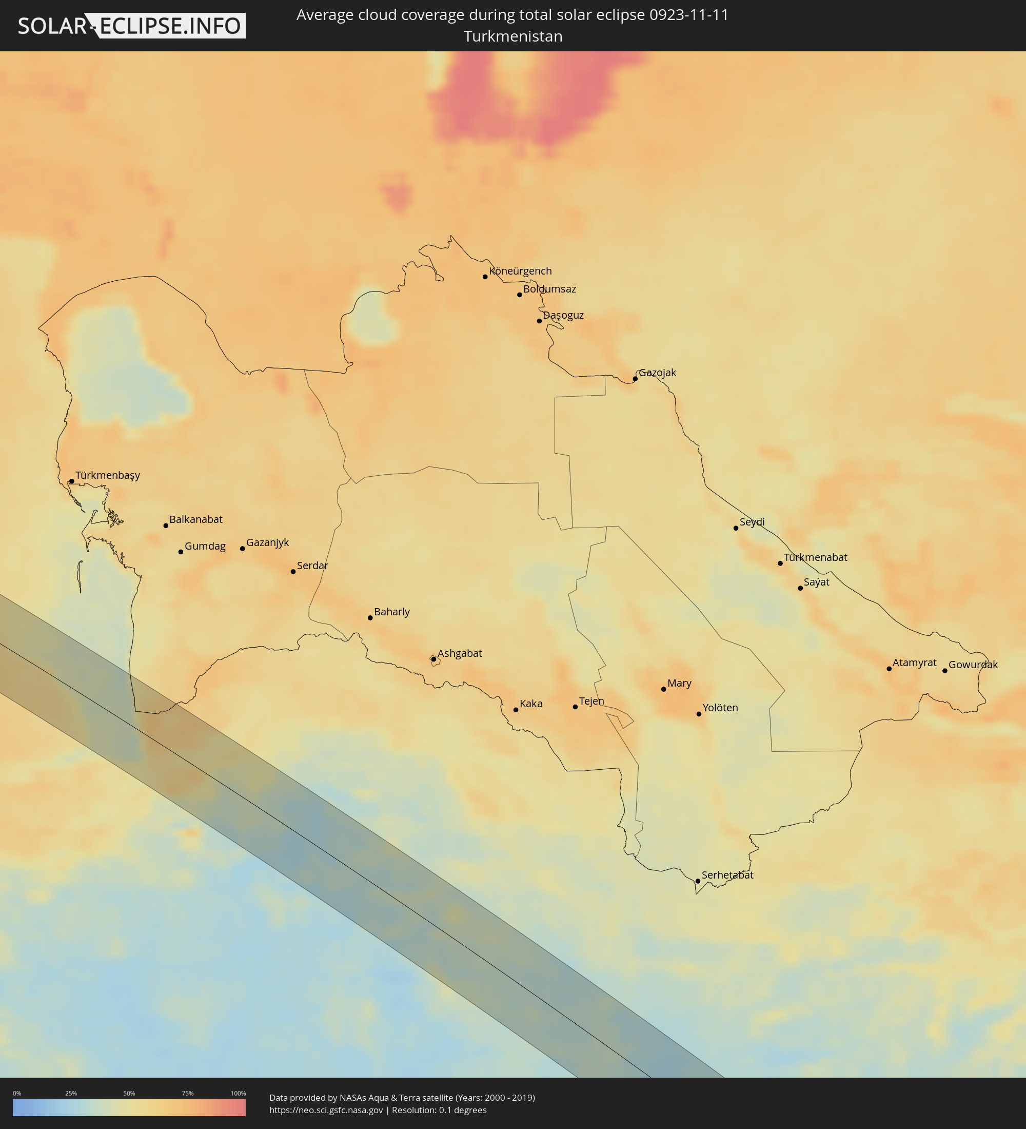 Turkmenistan
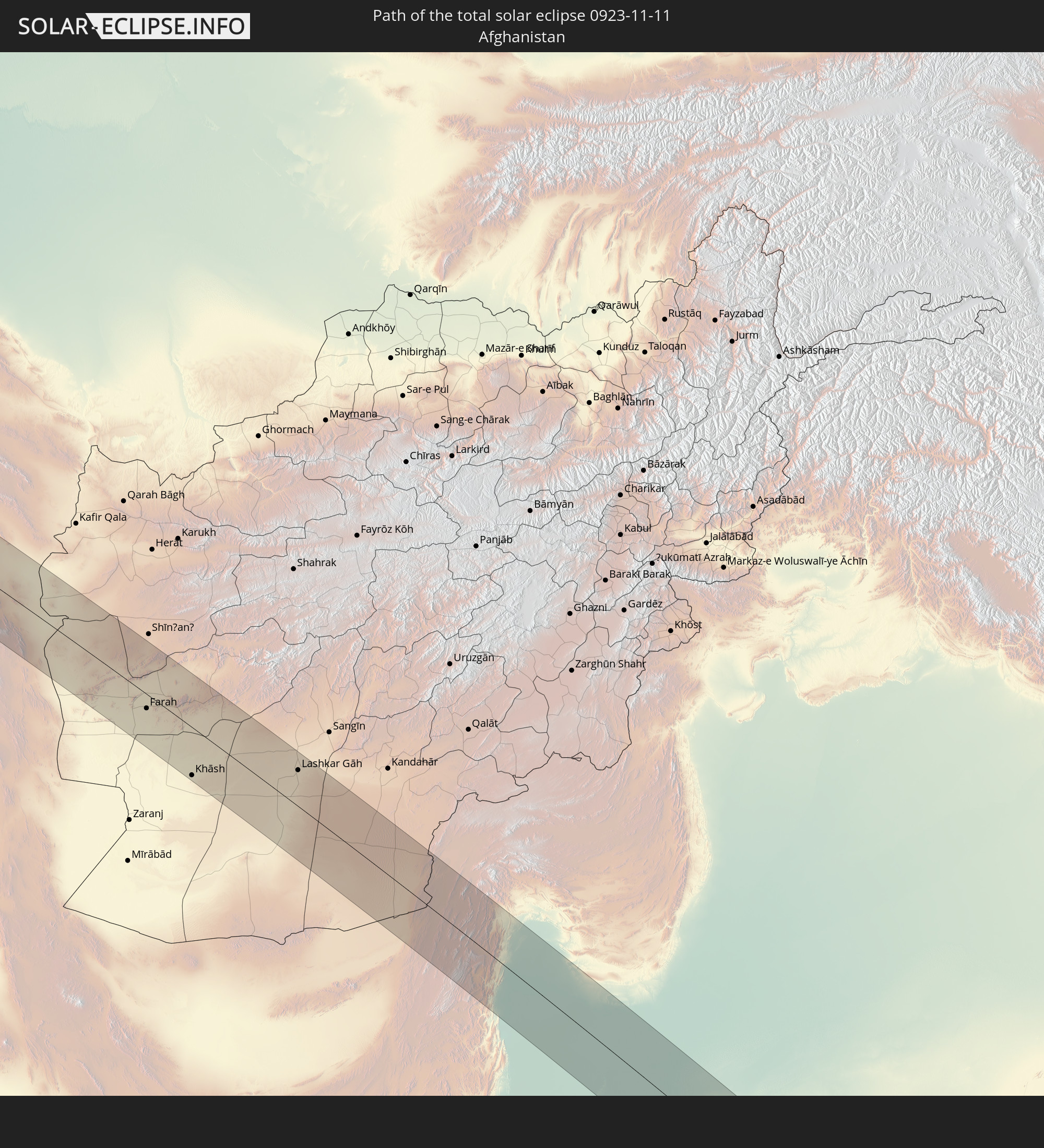
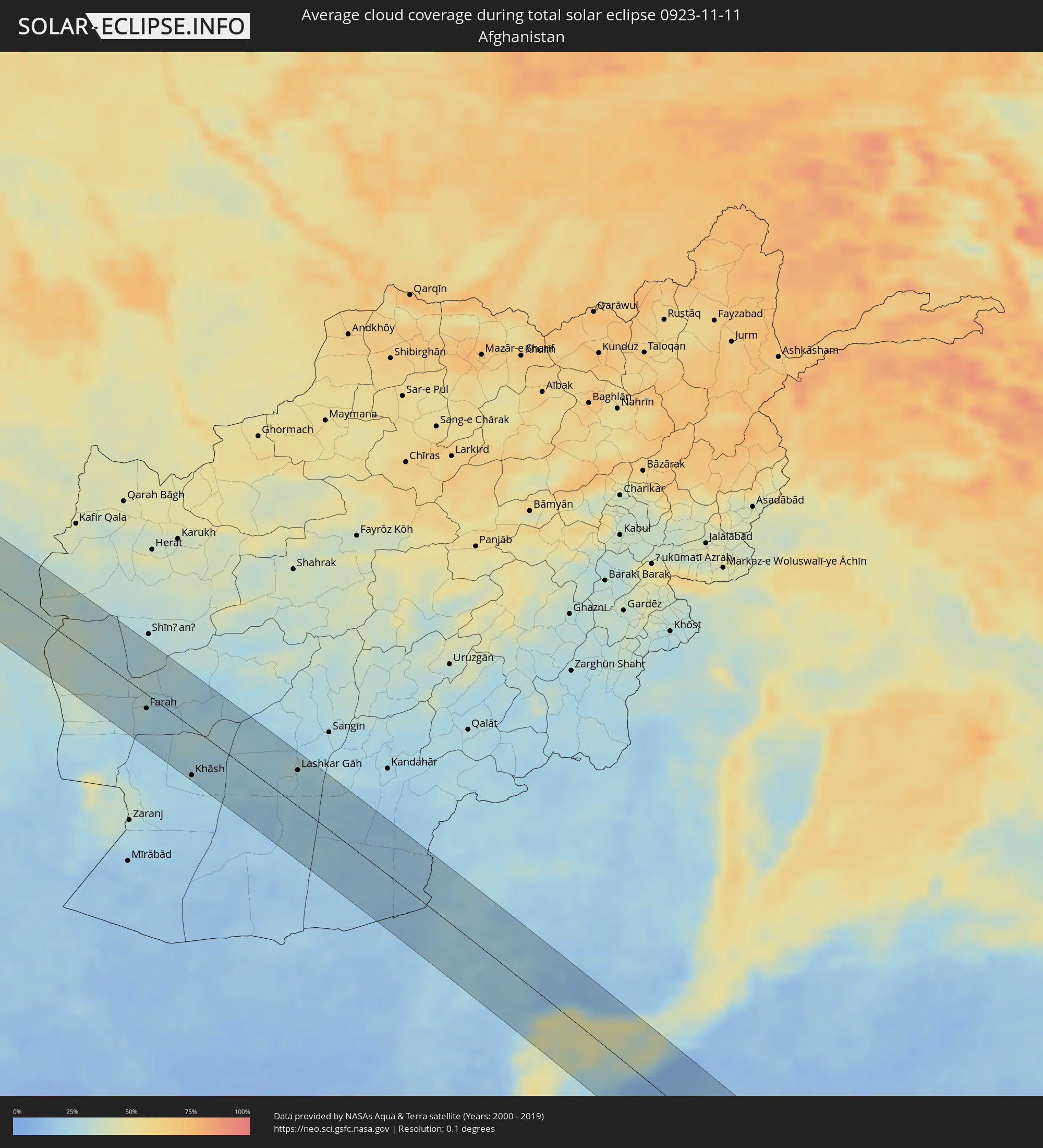 Afghanistan
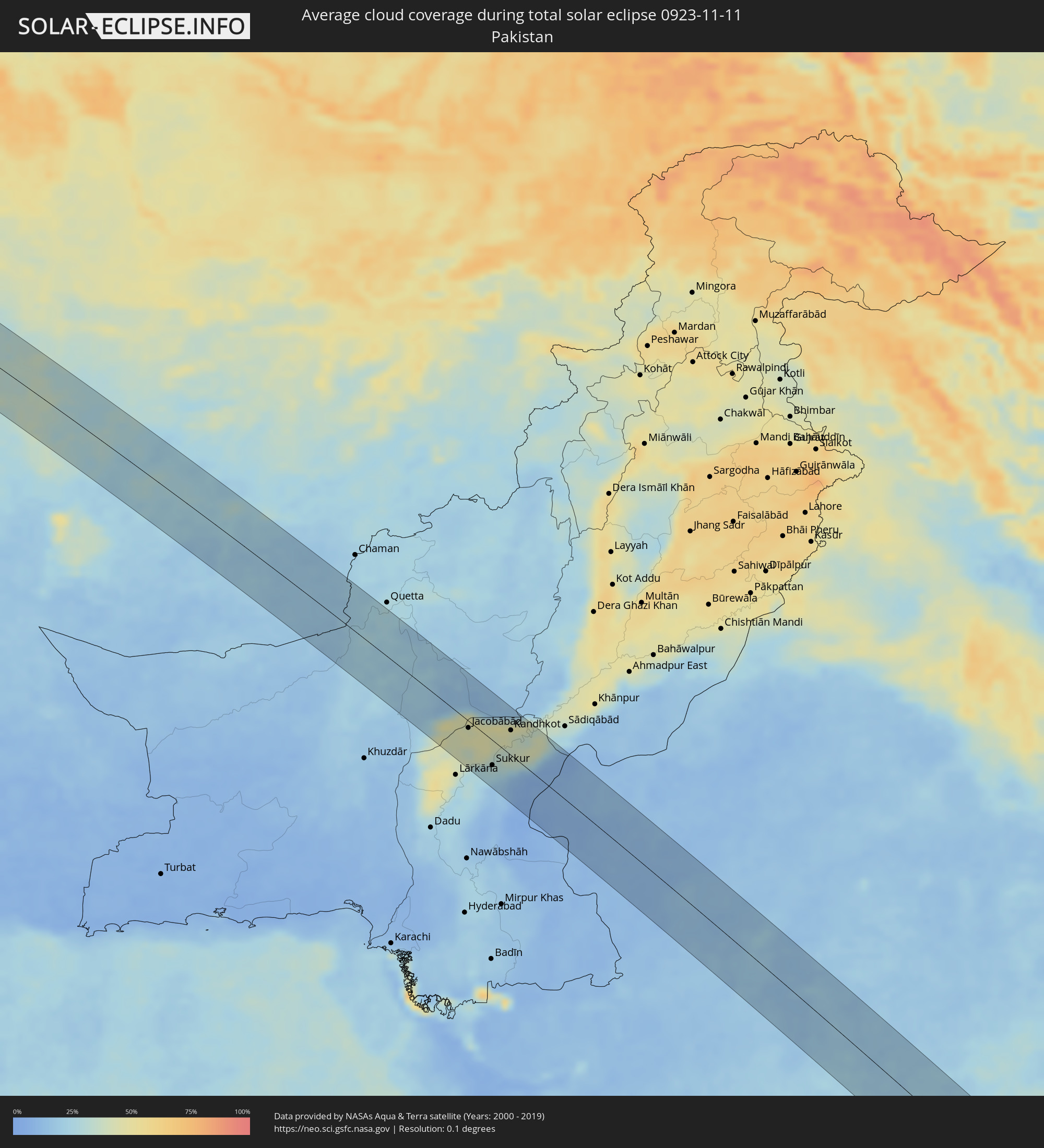 Pakistan
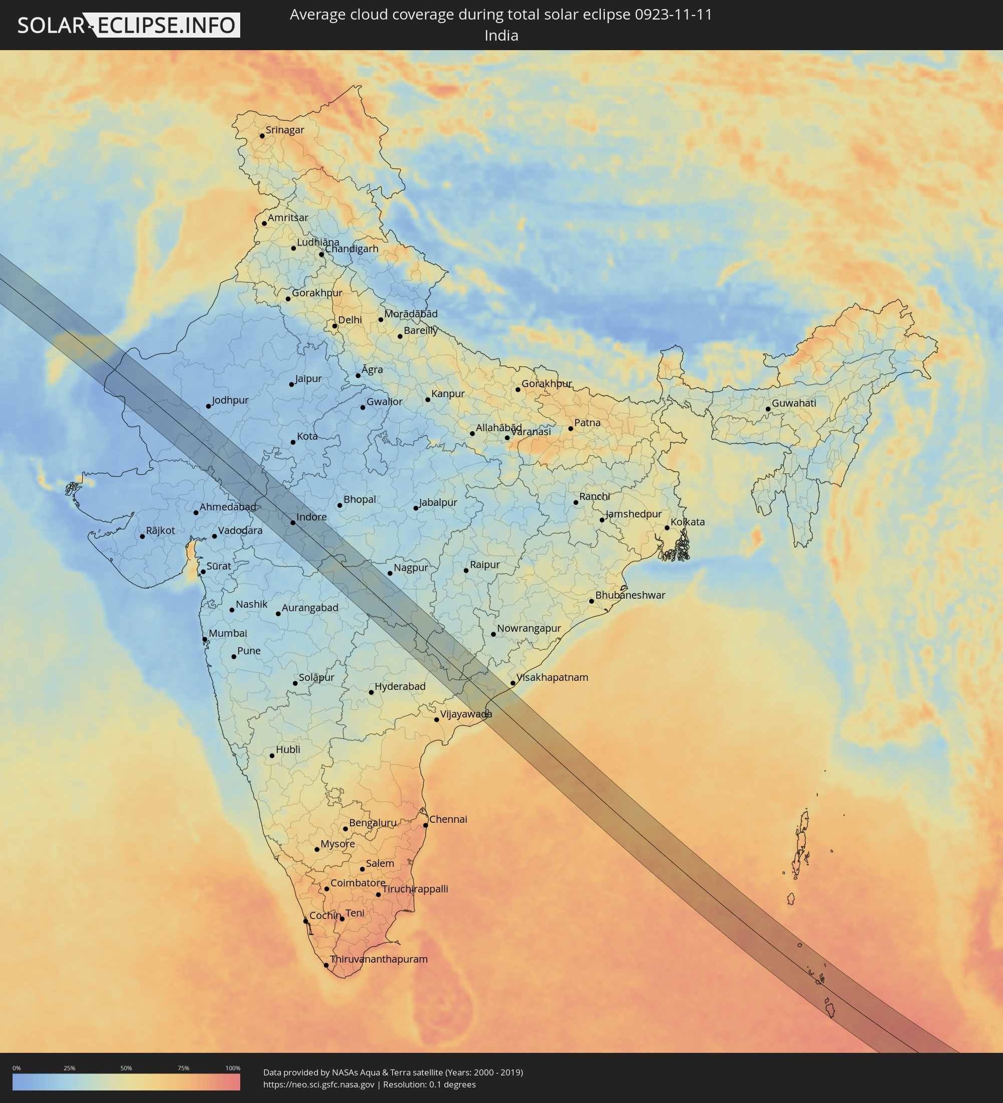 India
India
 Indonesia
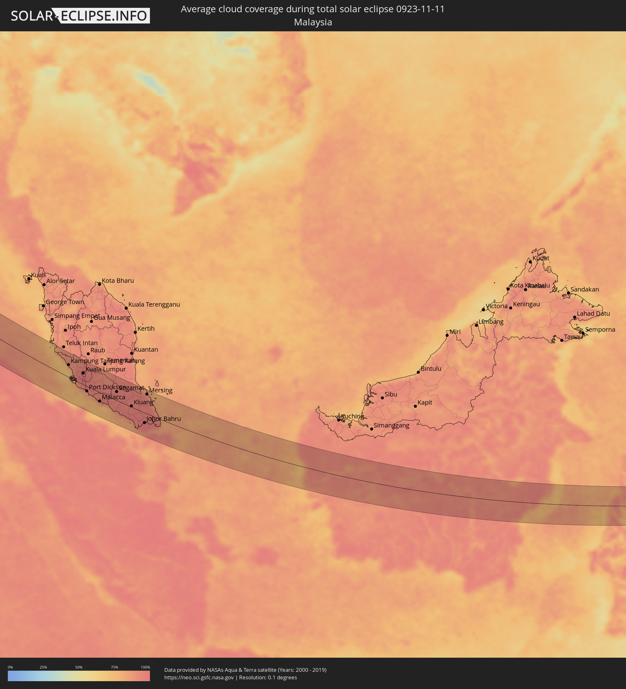 Malaysia
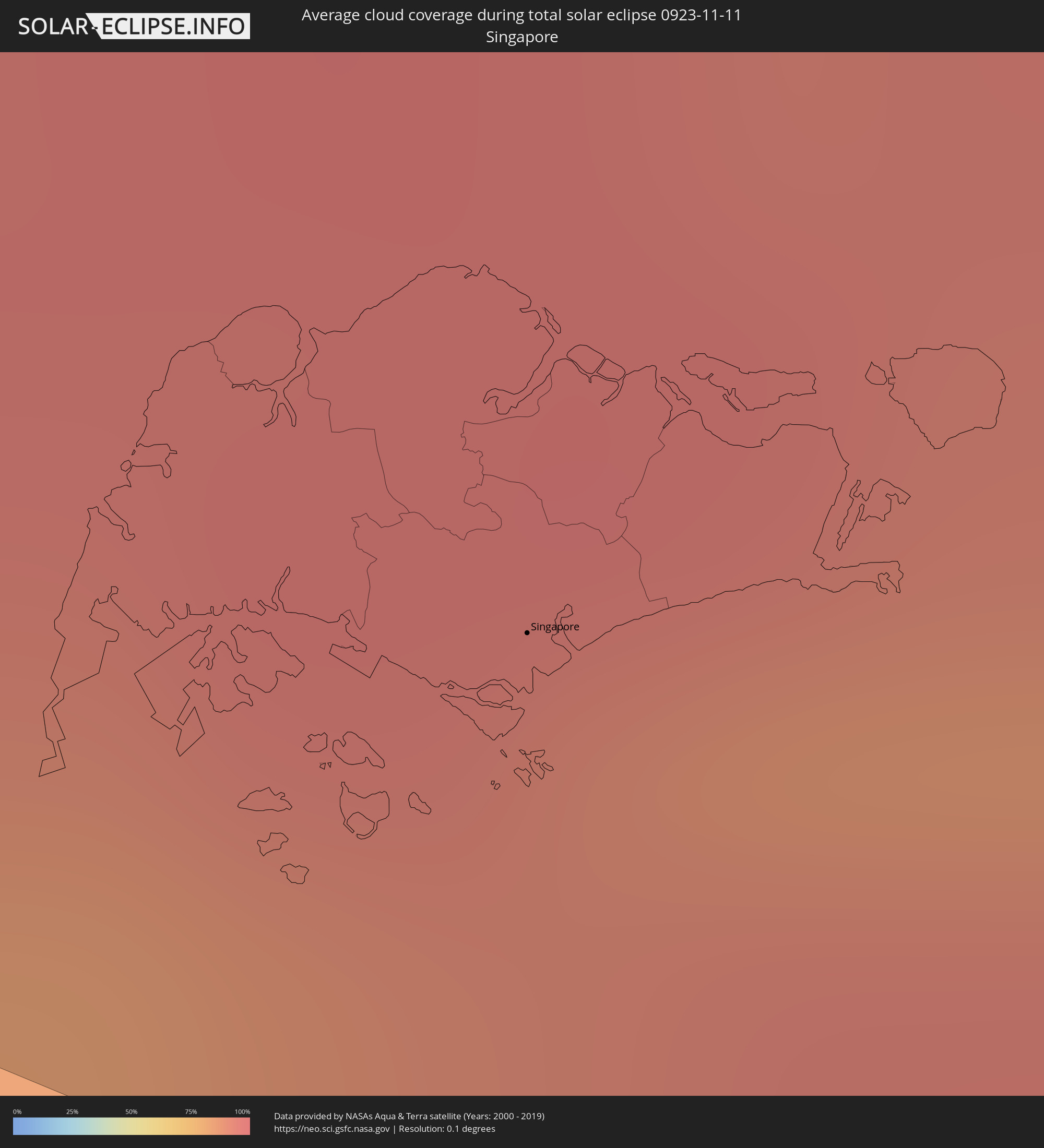 Singapore
Cities inside the path of the eclipse
The following table shows all locations with a population of more than 5,000 inside the eclipse path. Cities which have more than 100,000 inhabitants are marked bold. A click at the locations opens a detailed map.
| City | Type | Eclipse duration | Local time of max. eclipse | Distance to central line | Ø Cloud coverage |
|
Khosta, Krasnodarskiy
|
total | - | 06:53:04 UTC+02:30 | 33 km | 61% |
|
Kudepsta, Krasnodarskiy
|
total | - | 06:53:04 UTC+02:30 | 32 km | 61% |
|
Adler, Krasnodarskiy
|
total | - | 06:53:02 UTC+02:30 | 27 km | 60% |
|
Sokhumi, Abkhazia
|
total | - | 07:21:56 UTC+02:59 | 24 km | 59% |
|
Och’amch’ire, Abkhazia
|
total | - | 07:21:53 UTC+02:59 | 12 km | 55% |
|
P’ot’i, Samegrelo and Zemo Svaneti
|
total | - | 07:21:39 UTC+02:59 | 36 km | 63% |
|
Tqvarch'eli, Abkhazia
|
total | - | 07:22:00 UTC+02:59 | 33 km | 58% |
|
Zugdidi, Samegrelo and Zemo Svaneti
|
total | - | 07:21:53 UTC+02:59 | 7 km | 62% |
|
Ozurgeti, Guria
|
total | - | 07:21:38 UTC+02:59 | 46 km | 60% |
|
Senak’i, Samegrelo and Zemo Svaneti
|
total | - | 07:21:49 UTC+02:59 | 9 km | 60% |
|
Samtredia, Imereti
|
total | - | 07:21:49 UTC+02:59 | 10 km | 60% |
|
Kutaisi, Imereti
|
total | - | 07:21:58 UTC+02:59 | 15 km | 61% |
|
Akhaltsikhe, Samtskhe-Javakheti
|
total | - | 07:21:45 UTC+02:59 | 36 km | 67% |
|
Zestap’oni, Imereti
|
total | - | 07:21:59 UTC+02:59 | 13 km | 57% |
|
Borjomi, Samtskhe-Javakheti
|
total | - | 07:21:58 UTC+02:59 | 1 km | 59% |
|
Khashuri, Shida Kartli
|
total | - | 07:22:05 UTC+02:59 | 22 km | 59% |
|
Gori, Shida Kartli
|
total | - | 07:22:14 UTC+02:59 | 42 km | 63% |
|
Tashir, Lori Province
|
total | - | 07:20:43 UTC+02:58 | 36 km | 68% |
|
Step’anavan, Lori Province
|
total | - | 07:20:42 UTC+02:58 | 43 km | 67% |
|
Kaspi, Shida Kartli
|
total | - | 07:22:18 UTC+02:59 | 48 km | 64% |
|
Bolnisi, Kvemo Kartli
|
total | - | 07:22:07 UTC+02:59 | 6 km | 67% |
|
Alaverdi, Lori Province
|
total | - | 07:20:49 UTC+02:58 | 23 km | 65% |
|
Marneuli, Kvemo Kartli
|
total | - | 07:22:13 UTC+02:59 | 19 km | 69% |
|
Tbilisi, T'bilisi
|
total | - | 07:22:19 UTC+02:59 | 42 km | 69% |
|
Dilijan, Tavush Province
|
total | - | 07:20:43 UTC+02:58 | 51 km | 70% |
|
Rust’avi, Kvemo Kartli
|
total | - | 07:22:18 UTC+02:59 | 34 km | 71% |
|
Noyemberyan, Tavush Province
|
total | - | 07:20:57 UTC+02:58 | 3 km | 66% |
|
Ijevan, Tavush Province
|
total | - | 07:20:53 UTC+02:58 | 26 km | 66% |
|
Chambarak, Gegharkunik Province
|
total | - | 07:20:50 UTC+02:58 | 45 km | 71% |
|
Qazax, Qazax
|
total | - | 07:42:26 UTC+03:19 | 4 km | 66% |
|
Berd, Tavush Province
|
total | - | 07:20:57 UTC+02:58 | 16 km | 61% |
|
Shamkhor, Şǝmkir
|
total | - | 07:42:33 UTC+03:19 | 5 km | 65% |
|
Ganja, Gǝncǝ
|
total | - | 07:42:36 UTC+03:19 | 5 km | 73% |
|
Ağdam, Ağdam
|
total | - | 07:42:32 UTC+03:19 | 39 km | 68% |
|
Terter, Tǝrtǝr
|
total | - | 07:42:41 UTC+03:19 | 5 km | 72% |
|
Mingelchaur, Mingǝcevir
|
total | - | 07:42:53 UTC+03:19 | 41 km | 73% |
|
Barda, Bǝrdǝ
|
total | - | 07:42:46 UTC+03:19 | 7 km | 67% |
|
Yevlakh, Yevlax City
|
total | - | 07:42:52 UTC+03:19 | 31 km | 71% |
|
Agdzhabedy, Ağcabǝdi
|
total | - | 07:42:46 UTC+03:19 | 11 km | 70% |
|
Ağdaş, Ağdaş
|
total | - | 07:43:00 UTC+03:19 | 47 km | 71% |
|
Ujar, Ucar
|
total | - | 07:43:01 UTC+03:19 | 43 km | 73% |
|
Pārsābād, Ardabīl
|
total | - | 07:49:08 UTC+03:25 | 30 km | 70% |
|
Imishli, İmişli
|
total | - | 07:42:56 UTC+03:19 | 3 km | 71% |
|
Kyurdarmir, Kürdǝmir
|
total | - | 07:43:09 UTC+03:19 | 47 km | 73% |
|
Saatlı, Saatlı
|
total | - | 07:43:05 UTC+03:19 | 16 km | 72% |
|
Dzhalilabad, Jalilabad
|
total | - | 07:42:53 UTC+03:19 | 48 km | 69% |
|
Pushkino, Bilǝsuvar
|
total | - | 07:42:59 UTC+03:19 | 22 km | 69% |
|
Şirvan, Shirvan
|
total | - | 07:43:19 UTC+03:19 | 41 km | 76% |
|
Salyan, Salyan
|
total | - | 07:43:13 UTC+03:19 | 10 km | 74% |
|
Neftçala, Neftçala
|
total | - | 07:43:15 UTC+03:19 | 1 km | 76% |
|
Gorgān, Golestān
|
total | - | 07:51:32 UTC+03:25 | 2 km | 55% |
|
Shahrud, Semnān
|
total | - | 07:51:47 UTC+03:25 | 16 km | 46% |
|
Āzādshahr, Golestān
|
total | - | 07:52:01 UTC+03:25 | 56 km | 51% |
|
Kāshmar, Razavi Khorasan
|
total | - | 07:53:55 UTC+03:25 | 50 km | 38% |
|
Gonābād, Razavi Khorasan
|
total | - | 07:54:02 UTC+03:25 | 20 km | 34% |
|
Qā’en, Khorāsān-e Jonūbī
|
total | - | 07:54:23 UTC+03:25 | 52 km | 35% |
|
Anār Darah, Farah
|
total | - | 08:30:38 UTC+04:00 | 7 km | 29% |
|
Kushk, Herat
|
total | - | 08:30:51 UTC+04:00 | 58 km | 27% |
|
Farah, Farah
|
total | - | 08:31:03 UTC+04:00 | 16 km | 27% |
|
Khāsh, Nimroz
|
total | - | 08:31:44 UTC+04:00 | 54 km | 23% |
|
Markaz-e Ḩukūmat-e Darwēshān, Helmand
|
total | - | 08:33:05 UTC+04:00 | 10 km | 23% |
|
Lashkar Gāh, Helmand
|
total | - | 08:33:10 UTC+04:00 | 41 km | 25% |
|
Nushki, Balochistān
|
total | - | 09:03:25 UTC+04:28 | 44 km | 17% |
|
Kalāt, Balochistān
|
total | - | 09:04:10 UTC+04:28 | 56 km | 22% |
|
Mastung, Balochistān
|
total | - | 09:04:12 UTC+04:28 | 27 km | 25% |
|
Usta Muhammad, Balochistān
|
total | - | 09:06:00 UTC+04:28 | 42 km | 45% |
|
Ratodero, Sindh
|
total | - | 09:06:25 UTC+04:28 | 60 km | 40% |
|
Jacobābād, Sindh
|
total | - | 09:06:24 UTC+04:28 | 9 km | 44% |
|
Pīr jo Goth, Sindh
|
total | - | 09:06:53 UTC+04:28 | 58 km | 27% |
|
Shikārpur, Sindh
|
total | - | 09:06:45 UTC+04:28 | 25 km | 42% |
|
Khairpur, Sindh
|
total | - | 09:07:04 UTC+04:28 | 55 km | 23% |
|
Thul, Sindh
|
total | - | 09:06:48 UTC+04:28 | 8 km | 45% |
|
Sukkur, Sindh
|
total | - | 09:07:06 UTC+04:28 | 33 km | 29% |
|
Ghauspur, Sindh
|
total | - | 09:07:12 UTC+04:28 | 18 km | 36% |
|
Pāno Āqil, Sindh
|
total | - | 09:07:20 UTC+04:28 | 5 km | 37% |
|
Kandhkot, Sindh
|
total | - | 09:07:16 UTC+04:28 | 33 km | 41% |
|
Ghotki, Sindh
|
total | - | 09:07:31 UTC+04:28 | 21 km | 39% |
|
Khānpur, Sindh
|
total | - | 09:07:41 UTC+04:28 | 13 km | 30% |
|
Mīrpur Mathelo, Sindh
|
total | - | 09:07:47 UTC+04:28 | 37 km | 42% |
|
Khairpur, Sindh
|
total | - | 09:07:56 UTC+04:28 | 50 km | 41% |
|
Ubauro, Sindh
|
total | - | 09:07:56 UTC+04:28 | 60 km | 41% |
|
Udaipur, Rajasthan
|
total | - | 10:07:46 UTC+05:21 | 8 km | 19% |
|
Bānswāra, Rajasthan
|
total | - | 10:09:30 UTC+05:21 | 29 km | 17% |
|
Ratlām, Madhya Pradesh
|
total | - | 10:10:31 UTC+05:21 | 6 km | 21% |
|
Mandsaur, Madhya Pradesh
|
total | - | 10:10:02 UTC+05:21 | 58 km | 18% |
|
Māndu, Madhya Pradesh
|
total | - | 10:11:44 UTC+05:21 | 64 km | 20% |
|
Nagda, Madhya Pradesh
|
total | - | 10:10:58 UTC+05:21 | 30 km | 17% |
|
Ujjain, Madhya Pradesh
|
total | - | 10:11:42 UTC+05:21 | 31 km | 19% |
|
Indore, Madhya Pradesh
|
total | - | 10:12:08 UTC+05:21 | 4 km | 21% |
|
Dewas, Madhya Pradesh
|
total | - | 10:12:17 UTC+05:21 | 32 km | 20% |
|
Khandwa, Madhya Pradesh
|
total | - | 10:13:37 UTC+05:21 | 43 km | 18% |
|
Punāsa, Madhya Pradesh
|
total | - | 10:13:21 UTC+05:21 | 6 km | 22% |
|
Achalpur, Maharashtra
|
total | - | 10:15:54 UTC+05:21 | 11 km | 28% |
|
Amrāvati, Maharashtra
|
total | - | 10:16:34 UTC+05:21 | 21 km | 30% |
|
Yavatmāl, Maharashtra
|
total | - | 10:17:39 UTC+05:21 | 39 km | 30% |
|
Wardha, Maharashtra
|
total | - | 10:18:06 UTC+05:21 | 22 km | 30% |
|
Hinganghāt, Maharashtra
|
total | - | 10:18:41 UTC+05:21 | 23 km | 29% |
|
Chānda, Maharashtra
|
total | - | 10:20:00 UTC+05:21 | 5 km | 31% |
|
Rājahmundry, Andhra Pradesh
|
total | - | 10:27:27 UTC+05:21 | 61 km | 56% |
|
Kākināda, Andhra Pradesh
|
total | - | 10:28:21 UTC+05:21 | 32 km | 48% |
|
Reuleuet, Aceh
|
total | - | 13:02:44 UTC+07:07 | 65 km | 94% |
|
Lhokseumawe, Aceh
|
total | - | 13:05:03 UTC+07:07 | 16 km | 91% |
|
Langsa, Aceh
|
total | - | 13:08:16 UTC+07:07 | 34 km | 94% |
|
Medan, North Sumatra
|
total | - | 13:11:27 UTC+07:07 | 79 km | 98% |
|
Labuhan Deli, North Sumatra
|
total | - | 13:11:15 UTC+07:07 | 65 km | 97% |
|
Belawan, North Sumatra
|
total | - | 13:11:12 UTC+07:07 | 60 km | 96% |
|
Percut, North Sumatra
|
total | - | 13:11:54 UTC+07:07 | 64 km | 97% |
|
Tebingtinggi, North Sumatra
|
total | - | 13:13:08 UTC+07:07 | 76 km | 95% |
|
Tanjungbalai, North Sumatra
|
total | - | 13:15:22 UTC+07:07 | 77 km | 94% |
|
Kuala Selangor, Selangor
|
total | - | 13:06:50 UTC+06:55 | 37 km | 88% |
|
Kampong Dungun, Perak
|
total | - | 13:07:13 UTC+06:55 | 27 km | 80% |
|
Klang, Selangor
|
total | - | 13:07:50 UTC+06:55 | 15 km | 95% |
|
Kampung Baru Subang, Selangor
|
total | - | 13:07:53 UTC+06:55 | 31 km | 96% |
|
Rawang, Selangor
|
total | - | 13:07:45 UTC+06:55 | 50 km | 95% |
|
Kuala Lumpur, Kuala Lumpur
|
total | - | 13:08:18 UTC+06:55 | 38 km | 97% |
|
Sepang, Selangor
|
total | - | 13:09:07 UTC+06:55 | 4 km | 90% |
|
Port Dickson, Negeri Sembilan
|
total | - | 13:09:30 UTC+06:55 | 17 km | 83% |
|
Semenyih, Selangor
|
total | - | 13:09:00 UTC+06:55 | 27 km | 97% |
|
Seremban, Negeri Sembilan
|
total | - | 13:09:34 UTC+06:55 | 9 km | 96% |
|
Malacca, Melaka
|
total | - | 13:11:08 UTC+06:55 | 30 km | 82% |
|
Muar, Johor
|
total | - | 13:12:13 UTC+06:55 | 30 km | 81% |
|
Segamat, Johor
|
total | - | 13:12:12 UTC+06:55 | 29 km | 96% |
|
Batu Pahat, Johor
|
total | - | 13:13:27 UTC+06:55 | 32 km | 93% |
|
Kluang, Johor
|
total | - | 13:14:12 UTC+06:55 | 3 km | 95% |
|
Taman Senai, Johor
|
total | - | 13:15:40 UTC+06:55 | 26 km | 96% |
|
Johor Bahru, Johor
|
total | - | 13:16:09 UTC+06:55 | 35 km | 97% |
|
Ulu Tiram, Johor
|
total | - | 13:16:07 UTC+06:55 | 19 km | 97% |
|
Singapore, Central Singapore
|
total | - | 13:16:38 UTC+06:55 | 49 km | 90% |
|
Kota Tinggi, Johor
|
total | - | 13:16:09 UTC+06:55 | 1 km | 95% |
|
Tanjungpinang, Riau Islands
|
total | - | 13:30:31 UTC+07:07 | 62 km | 92% |
|
Kijang, Riau Islands
|
total | - | 13:31:00 UTC+07:07 | 57 km | 93% |
|
Sungai Raya, West Kalimantan
|
total | - | 13:42:06 UTC+07:07 | 71 km | 84% |
|
Pontianak, West Kalimantan
|
total | - | 13:44:03 UTC+07:07 | 5 km | 94% |
|
City of Balikpapan, East Kalimantan
|
total | - | 14:52:50 UTC+07:57 | 1 km | 88% |
|
Loa Janan, East Kalimantan
|
total | - | 14:52:38 UTC+07:57 | 75 km | 95% |
|
Palu, Central Sulawesi
|
total | - | 14:58:22 UTC+07:57 | 48 km | 90% |
|
Poso, Central Sulawesi
|
total | - | 15:00:23 UTC+07:57 | 6 km | 71% |
|
Luwuk, Central Sulawesi
|
total | - | 15:03:36 UTC+07:57 | 36 km | 76% |
|
Sorong, West Papua
|
total | - | 16:40:46 UTC+09:22 | 64 km | 83% |