Total solar eclipse of 07/09/0948
| Day of week: | Tuesday |
| Maximum duration of eclipse: | 03m27s |
| Maximum width of eclipse path: | 431 km |
| Saros cycle: | 90 |
| Coverage: | 100% |
| Magnitude: | 1.0621 |
| Gamma: | 0.8793 |
Wo kann man die Sonnenfinsternis vom 07/09/0948 sehen?
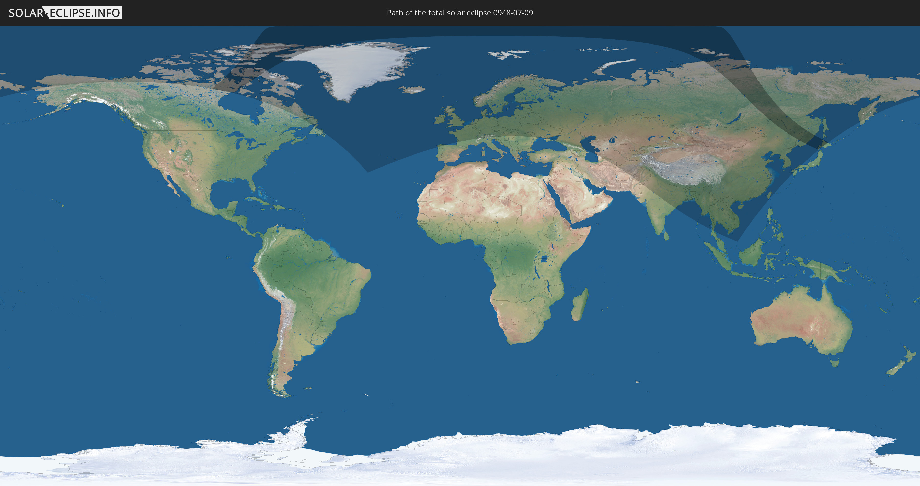
Die Sonnenfinsternis am 07/09/0948 kann man in 66 Ländern als partielle Sonnenfinsternis beobachten.
Der Finsternispfad verläuft durch 5 Länder. Nur in diesen Ländern ist sie als total Sonnenfinsternis zu sehen.
In den folgenden Ländern ist die Sonnenfinsternis total zu sehen
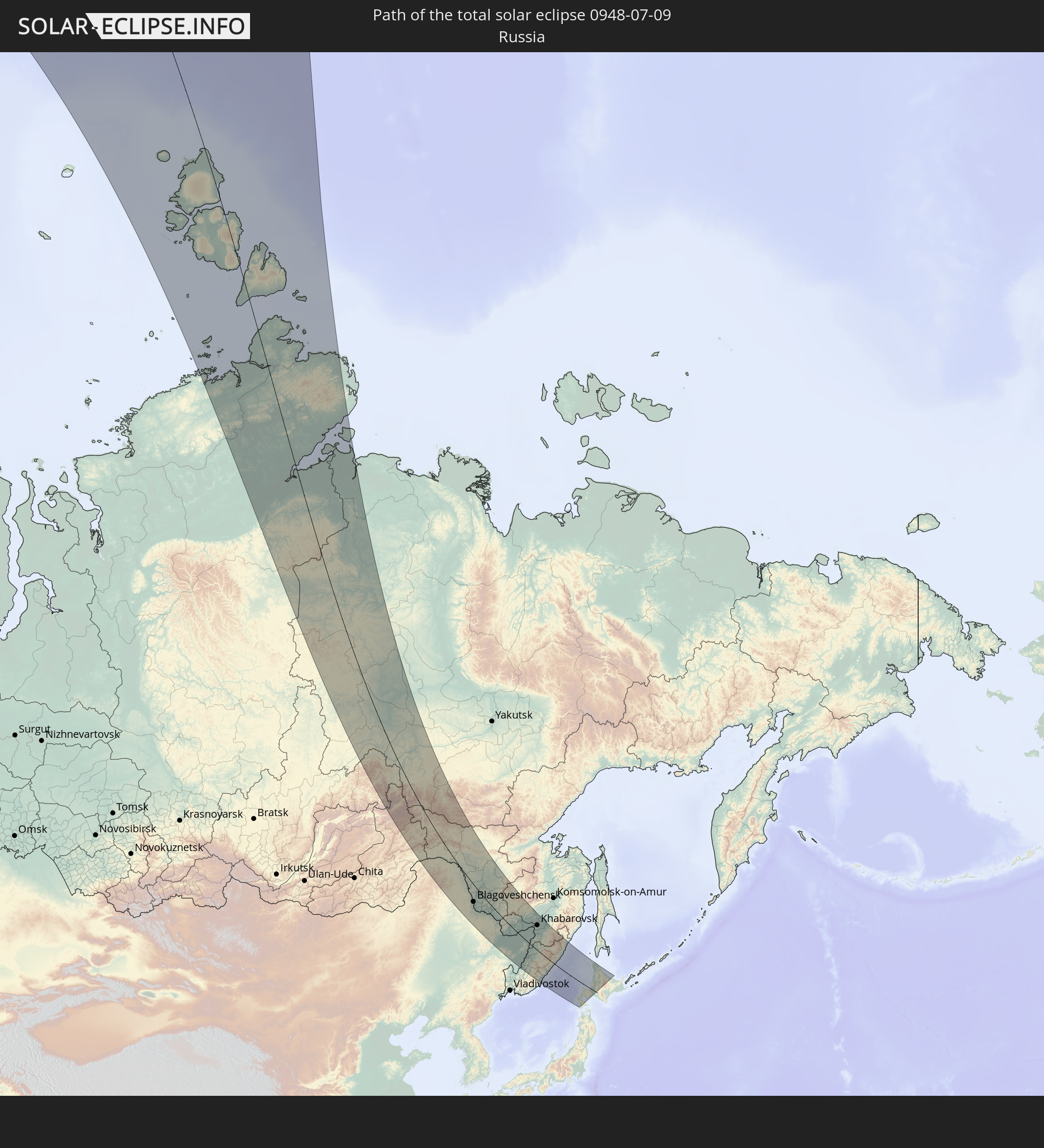 Russia
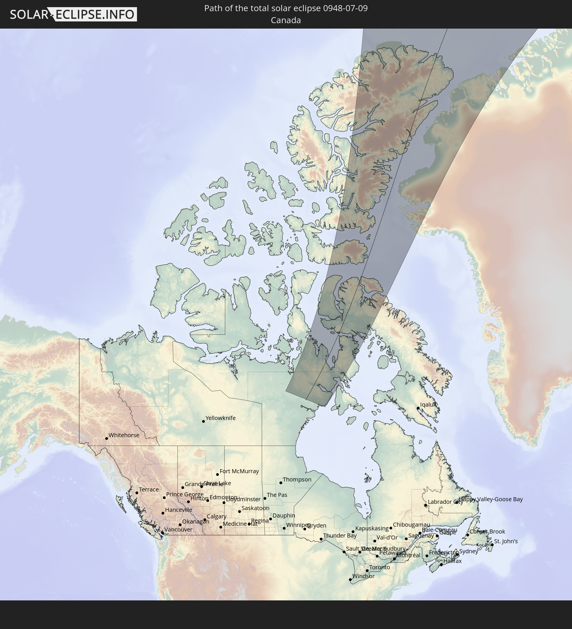 Canada
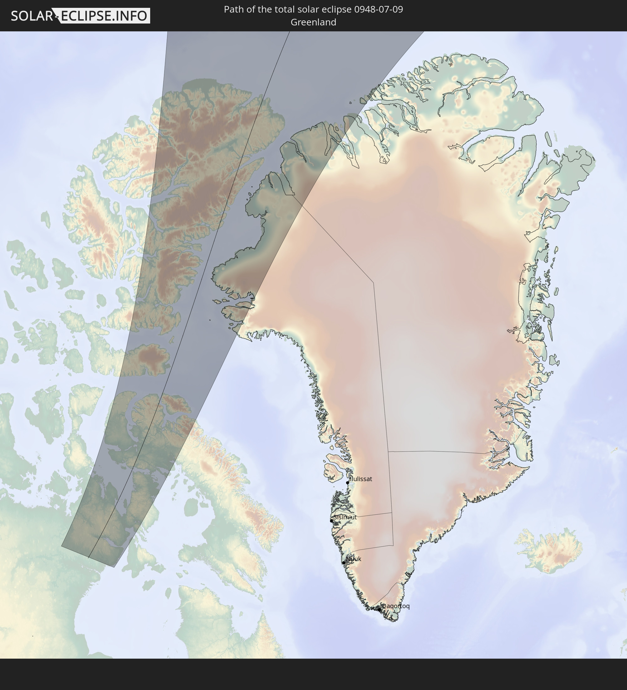 Greenland
 China
China
 Japan
Japan
In den folgenden Ländern ist die Sonnenfinsternis partiell zu sehen
 Russia
 United States
 Canada
 Greenland
 Portugal
 Iceland
 Spain
Spain
 Republic of Ireland
 Svalbard and Jan Mayen
 United Kingdom
 Faroe Islands
 France
 Isle of Man
 Guernsey
 Jersey
 Belgium
 Netherlands
 Norway
 Luxembourg
 Germany
 Switzerland
 Italy
Italy
 Denmark
 Liechtenstein
 Austria
 Sweden
 Czechia
 Slovenia
 Poland
 Hungary
 Slovakia
 Åland Islands
 Romania
 Finland
 Lithuania
 Latvia
 Estonia
 Ukraine
 Belarus
 Moldova
 Iran
Iran
 Azerbaijan
 Kazakhstan
 Turkmenistan
 Uzbekistan
 Afghanistan
 Pakistan
 Tajikistan
 India
India
 Kyrgyzstan
 China
China
 Nepal
Nepal
 Mongolia
 Bangladesh
 Bhutan
 Myanmar
 Thailand
 Laos
Laos
 Vietnam
 Cambodia
 Macau
Macau
 Hong Kong
 Taiwan
 Japan
Japan
 North Korea
 South Korea
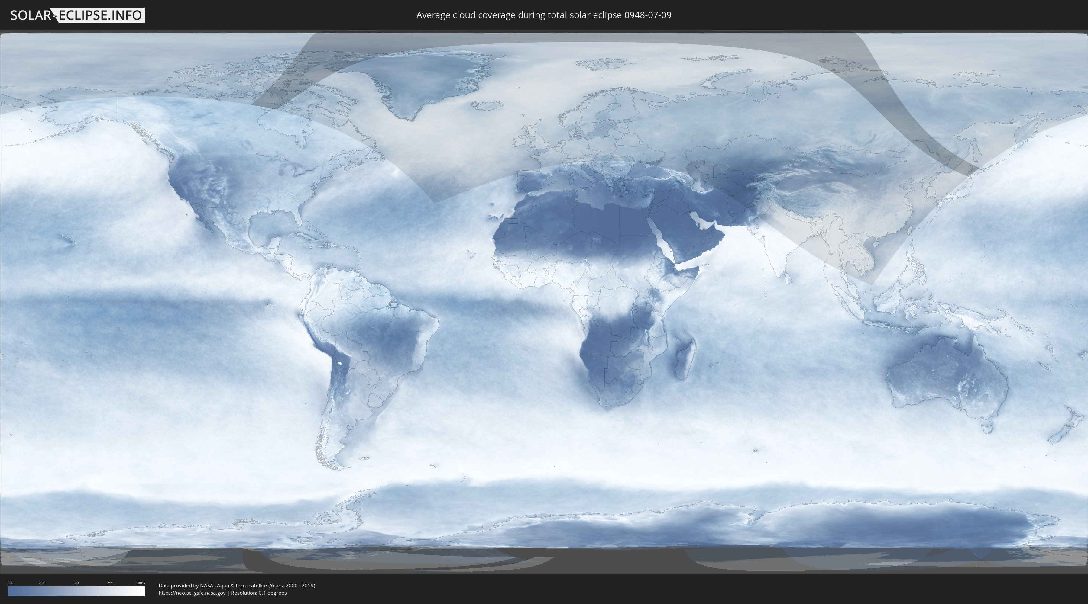
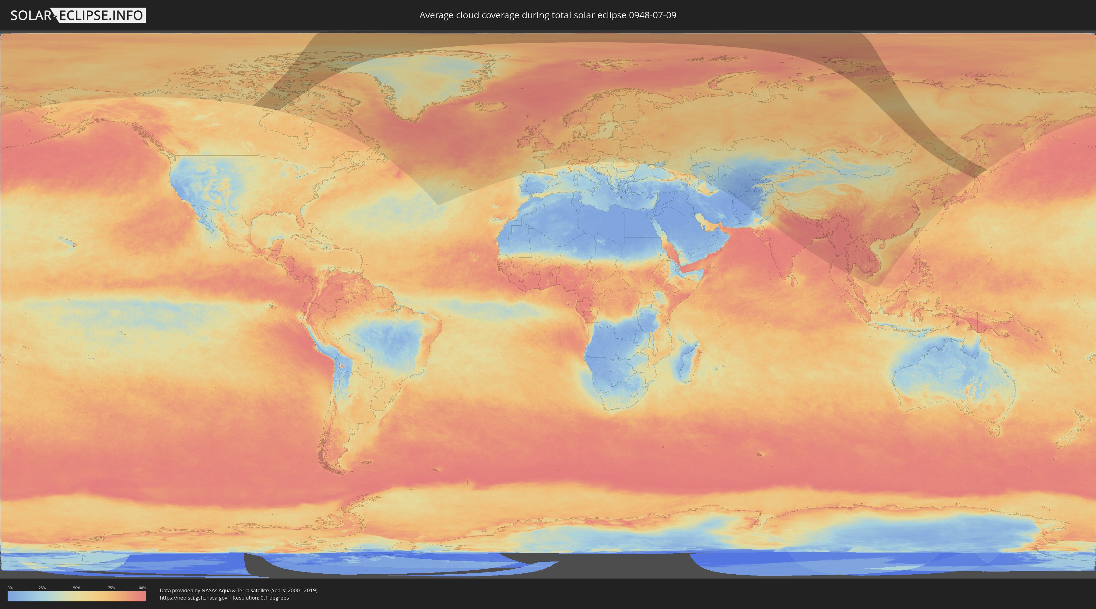
How will be the weather during the total solar eclipse on 07/09/0948?
Where is the best place to see the total solar eclipse of 07/09/0948?
The following maps show the average cloud coverage for the day of the total solar eclipse.
With the help of these maps, it is possible to find the place along the eclipse path, which has the best
chance of a cloudless sky.
Nevertheless, you should consider local circumstances and inform about the weather of your chosen
observation site.
The data is provided by NASAs satellites
AQUA and TERRA.
The cloud maps are averaged over a period of 19 years (2000 - 2019).
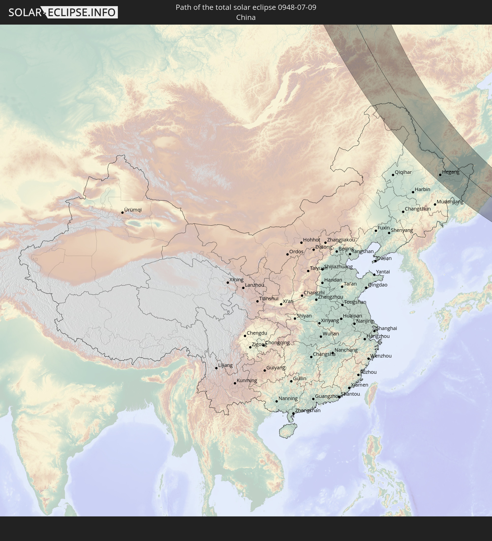
Detailed country maps
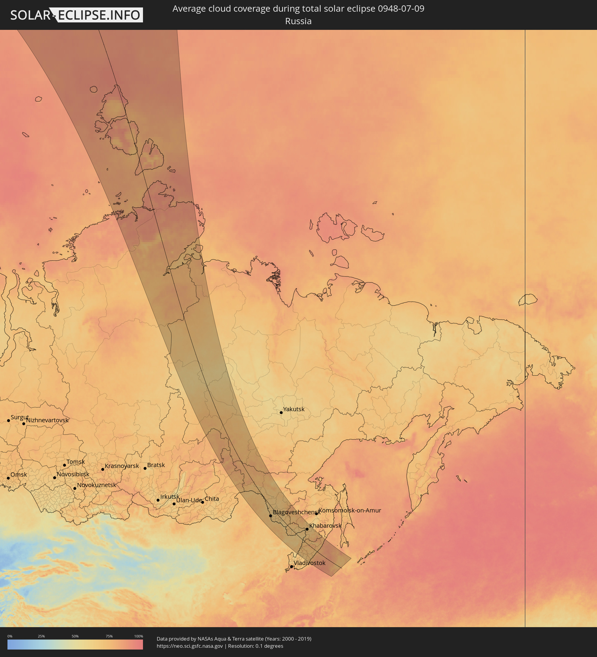 Russia
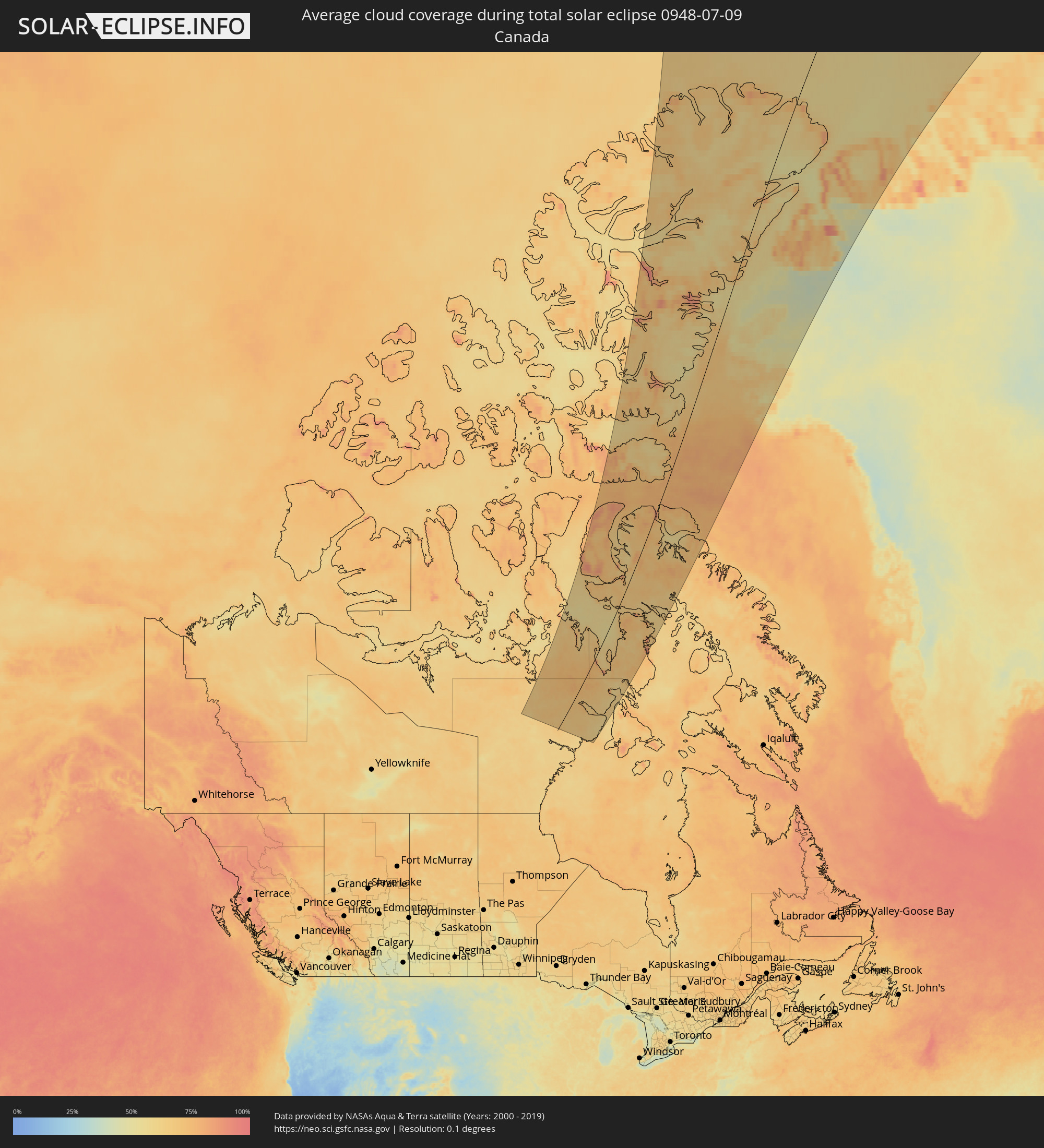 Canada
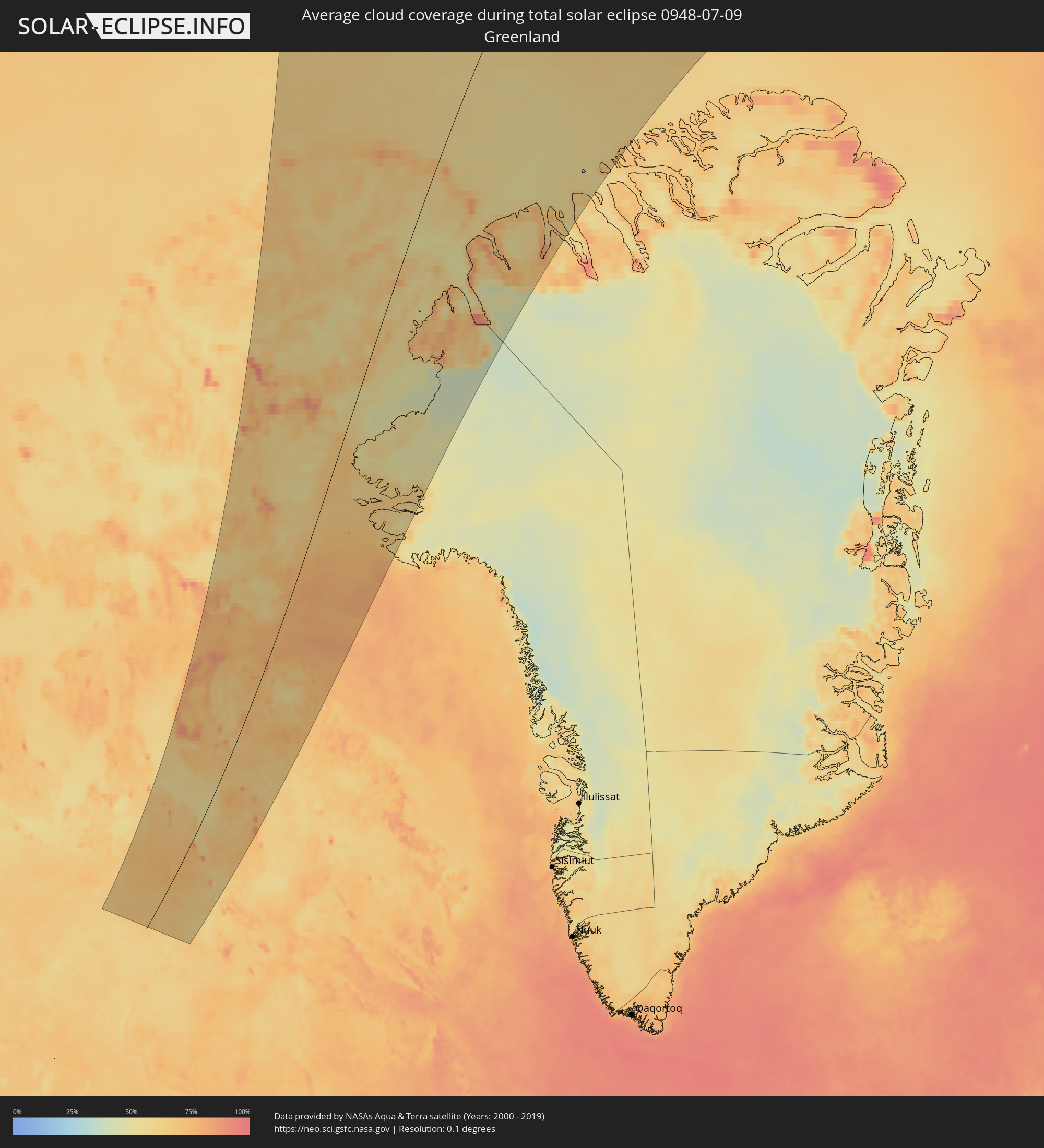 Greenland
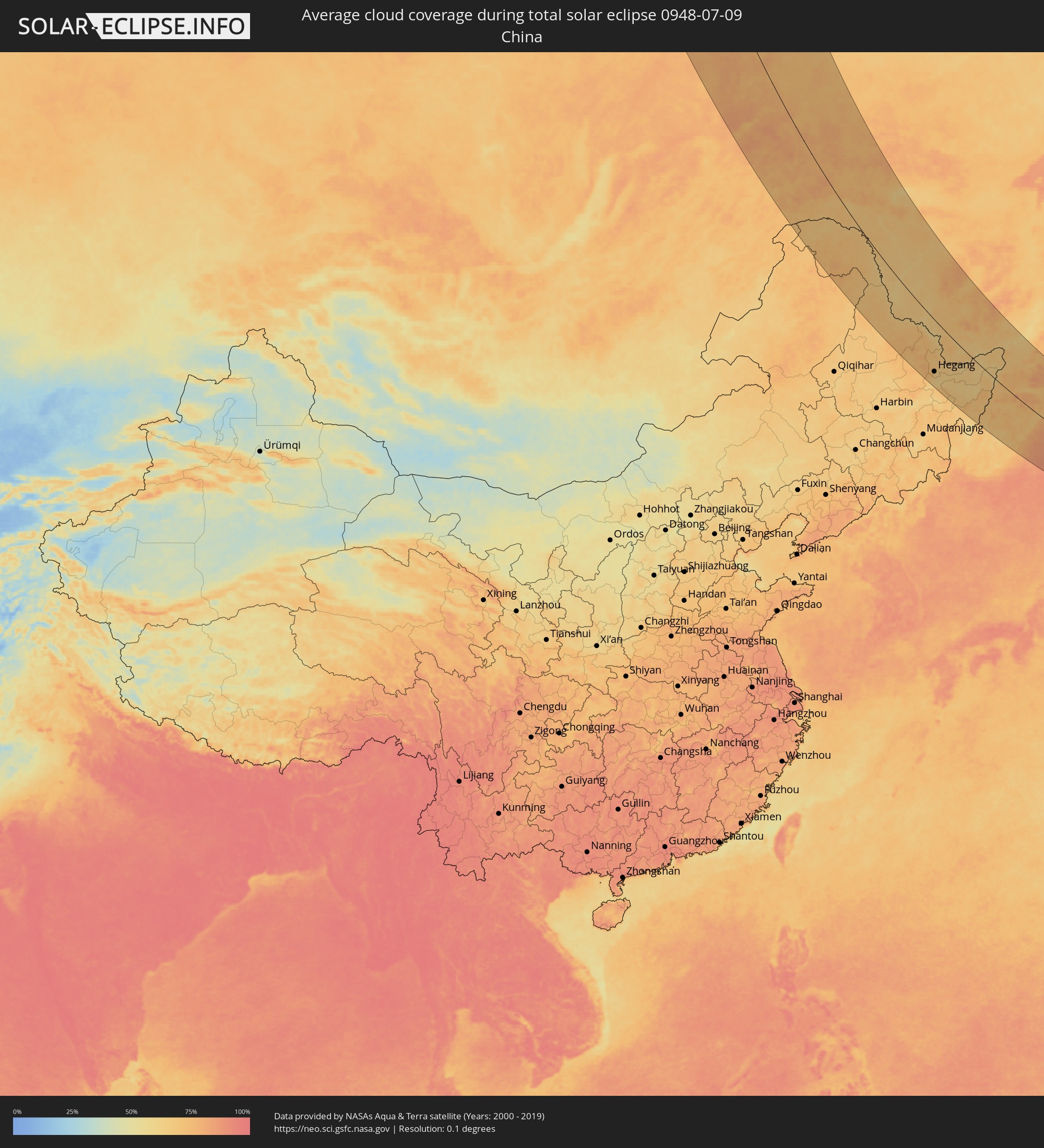 China
China
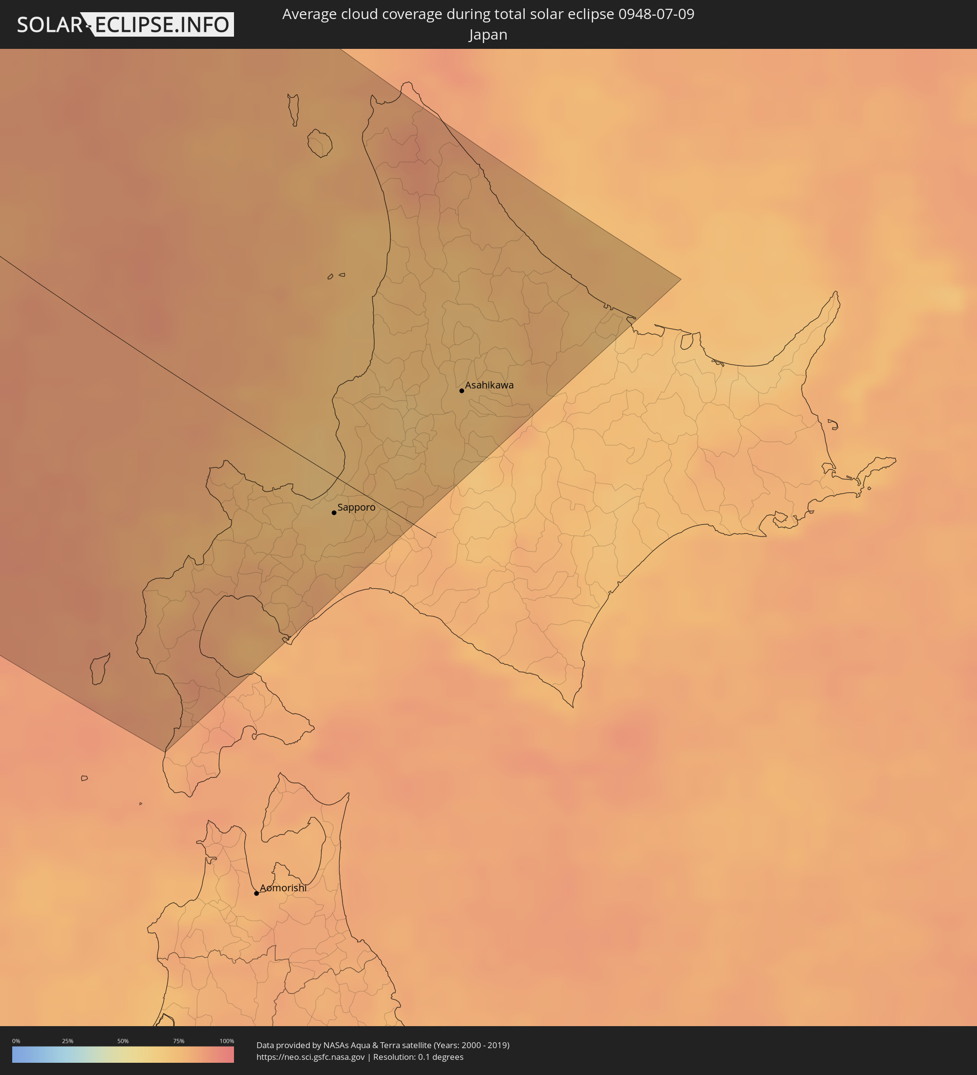 Japan
Japan
Cities inside the path of the eclipse
The following table shows all locations with a population of more than 5,000 inside the eclipse path. Cities which have more than 100,000 inhabitants are marked bold. A click at the locations opens a detailed map.
| City | Type | Eclipse duration | Local time of max. eclipse | Distance to central line | Ø Cloud coverage |
|
Aykhal, Sakha
|
total | - | 18:10:46 UTC+08:38 | 70 km | 63% |
|
Udachny, Sakha
|
total | - | 18:09:58 UTC+08:38 | 23 km | 64% |
|
Chernyshevskiy, Sakha
|
total | - | 18:16:13 UTC+08:38 | 151 km | 68% |
|
Mirny, Sakha
|
total | - | 18:17:13 UTC+08:38 | 105 km | 71% |
|
Lensk, Sakha
|
total | - | 18:20:32 UTC+08:38 | 142 km | 73% |
|
Suntar, Sakha
|
total | - | 18:18:04 UTC+08:38 | 60 km | 69% |
|
Nyurba, Sakha
|
total | - | 18:16:02 UTC+08:38 | 139 km | 65% |
|
Olyokminsk, Sakha
|
total | - | 18:21:11 UTC+08:38 | 119 km | 71% |
|
Yerofey Pavlovich, Amur
|
total | - | 18:32:03 UTC+08:38 | 146 km | 73% |
|
Skovorodino, Amur
|
total | - | 18:31:44 UTC+08:38 | 38 km | 71% |
|
Neryungri, Sakha
|
total | - | 18:27:11 UTC+08:38 | 158 km | 75% |
|
Tynda, Amur
|
total | - | 18:29:41 UTC+08:38 | 81 km | 74% |
|
Tahe, Heilongjiang
|
total | - | 17:55:20 UTC+08:00 | 100 km | 72% |
|
Chul’man, Sakha
|
total | - | 18:26:51 UTC+08:38 | 183 km | 75% |
|
Magdagachi, Amur
|
total | - | 18:32:18 UTC+08:38 | 32 km | 67% |
|
Zeya, Amur
|
total | - | 18:31:33 UTC+08:38 | 128 km | 68% |
|
Heihe, Heilongjiang
|
total | - | 17:58:03 UTC+08:00 | 97 km | 64% |
|
Blagoveshchensk, Amur
|
total | - | 18:36:57 UTC+08:38 | 91 km | 66% |
|
Shimanovsk, Amur
|
total | - | 18:34:13 UTC+08:38 | 46 km | 67% |
|
Konstantinovka, Amur
|
total | - | 18:37:51 UTC+08:38 | 118 km | 64% |
|
Srednebelaya, Amur
|
total | - | 18:36:14 UTC+08:38 | 39 km | 63% |
|
Tambovka, Amur
|
total | - | 18:37:05 UTC+08:38 | 78 km | 65% |
|
Svobodnyy, Amur
|
total | - | 18:35:06 UTC+08:38 | 19 km | 65% |
|
Seryshevo, Amur
|
total | - | 18:35:28 UTC+08:38 | 12 km | 67% |
|
Belogorsk, Amur
|
total | - | 18:35:43 UTC+08:38 | 5 km | 66% |
|
Poyarkovo, Amur
|
total | - | 18:37:39 UTC+08:38 | 80 km | 63% |
|
Youhao, Heilongjiang
|
total | - | 18:01:19 UTC+08:00 | 208 km | 69% |
|
Yichun, Heilongjiang
|
total | - | 18:01:30 UTC+08:00 | 215 km | 72% |
|
Yekaterinoslavka, Amur
|
total | - | 18:36:24 UTC+08:38 | 12 km | 68% |
|
Raychikhinsk, Amur
|
total | - | 18:37:12 UTC+08:38 | 28 km | 66% |
|
Zavitinsk, Amur
|
total | - | 18:36:42 UTC+08:38 | 2 km | 67% |
|
Xinqing, Heilongjiang
|
total | - | 18:00:28 UTC+08:00 | 137 km | 70% |
|
Bureya, Amur
|
total | - | 18:37:03 UTC+08:38 | 16 km | 61% |
|
Novobureyskiy, Amur
|
total | - | 18:37:04 UTC+08:38 | 11 km | 62% |
|
Arkhara, Amur
|
total | - | 18:37:33 UTC+08:38 | 19 km | 64% |
|
Talakan, Amur
|
total | - | 18:36:14 UTC+08:38 | 53 km | 66% |
|
Hegang, Heilongjiang
|
total | - | 18:01:36 UTC+08:00 | 170 km | 71% |
|
Jiamusi, Heilongjiang
|
total | - | 18:02:24 UTC+08:00 | 214 km | 67% |
|
Fengxiang, Heilongjiang
|
total | - | 18:01:06 UTC+08:00 | 125 km | 67% |
|
Amurzet, Jewish Autonomous Oblast
|
total | - | 18:48:21 UTC+08:47 | 101 km | 67% |
|
Fuli, Heilongjiang
|
total | - | 18:02:14 UTC+08:00 | 178 km | 69% |
|
Lingdong, Heilongjiang
|
total | - | 18:02:27 UTC+08:00 | 191 km | 70% |
|
Shuangyashan, Heilongjiang
|
total | - | 18:02:21 UTC+08:00 | 185 km | 70% |
|
Baoshan, Heilongjiang
|
total | - | 18:02:22 UTC+08:00 | 177 km | 67% |
|
Fujin, Heilongjiang
|
total | - | 18:01:09 UTC+08:00 | 88 km | 64% |
|
Baoqing, Heilongjiang
|
total | - | 18:02:25 UTC+08:00 | 156 km | 67% |
|
Novyy Urgal, Khabarovsk Krai
|
total | - | 18:42:53 UTC+08:47 | 237 km | 69% |
|
Leninskoye, Jewish Autonomous Oblast
|
total | - | 18:47:29 UTC+08:47 | 3 km | 63% |
|
Birobidzhan, Jewish Autonomous Oblast
|
total | - | 18:46:08 UTC+08:47 | 81 km | 67% |
|
Lesozavodsk, Primorskiy
|
total | - | 18:50:40 UTC+08:47 | 168 km | 69% |
|
Kirovskiy, Primorskiy
|
total | - | 18:51:11 UTC+08:47 | 197 km | 65% |
|
Gornyye Klyuchi, Primorskiy
|
total | - | 18:50:58 UTC+08:47 | 184 km | 68% |
|
Dal’nerechensk, Primorskiy
|
total | - | 18:49:55 UTC+08:47 | 113 km | 69% |
|
Smidovich, Jewish Autonomous Oblast
|
total | - | 18:46:07 UTC+08:47 | 111 km | 70% |
|
Luchegorsk, Primorskiy
|
total | - | 18:48:59 UTC+08:47 | 44 km | 72% |
|
Bikin, Khabarovsk Krai
|
total | - | 18:48:29 UTC+08:47 | 13 km | 68% |
|
Fuyuan, Heilongjiang
|
total | - | 17:58:46 UTC+08:00 | 116 km | 64% |
|
Vyazemskiy, Khabarovsk Krai
|
total | - | 18:47:17 UTC+08:47 | 73 km | 70% |
|
Khor, Khabarovsk Krai
|
total | - | 18:46:43 UTC+08:47 | 111 km | 68% |
|
Kavalerovo, Primorskiy
|
total | - | 18:51:39 UTC+08:47 | 194 km | 67% |
|
Korfovskiy, Khabarovsk Krai
|
total | - | 18:46:12 UTC+08:47 | 144 km | 71% |
|
Khabarovsk, Khabarovsk Krai
|
total | - | 18:45:49 UTC+08:47 | 167 km | 67% |
|
Khabarovsk Vtoroy, Khabarovsk Krai
|
total | - | 18:45:52 UTC+08:47 | 166 km | 68% |
|
Nekrasovka, Khabarovsk Krai
|
total | - | 18:45:57 UTC+08:47 | 163 km | 70% |
|
Knyaze-Volkonskoye, Khabarovsk Krai
|
total | - | 18:45:42 UTC+08:47 | 184 km | 66% |
|
Dal'negorsk, Primorskiy
|
total | - | 18:51:03 UTC+08:47 | 144 km | 68% |
|
Plastun, Primorskiy
|
total | - | 18:50:28 UTC+08:47 | 92 km | 73% |
|
Iwanai, Hokkaido
|
total | - | 19:03:16 UTC+09:00 | 65 km | 76% |
|
Yoichi, Hokkaido
|
total | - | 19:02:50 UTC+09:00 | 32 km | 73% |
|
Date, Hokkaido
|
total | - | 19:03:42 UTC+09:00 | 98 km | 78% |
|
Otaru, Hokkaido
|
total | - | 19:02:44 UTC+09:00 | 28 km | 71% |
|
Sapporo, Hokkaido
|
total | - | 19:02:42 UTC+09:00 | 20 km | 71% |
|
Ishikari, Hokkaido
|
total | - | 19:02:29 UTC+09:00 | 12 km | 70% |
|
Tōbetsu, Hokkaido
|
total | - | 19:02:26 UTC+09:00 | 1 km | 73% |
|
Ebetsu, Hokkaido
|
total | - | 19:02:33 UTC+09:00 | 12 km | 74% |
|
Kitahiroshima, Hokkaido
|
total | - | 19:02:42 UTC+09:00 | 27 km | 76% |
|
Rumoi, Hokkaido
|
total | - | 19:01:28 UTC+09:00 | 76 km | 71% |
|
Chitose, Hokkaido
|
total | - | 19:02:51 UTC+09:00 | 34 km | 79% |
|
Wakkanai, Hokkaido
|
total | - | 18:59:35 UTC+09:00 | 213 km | 81% |
|
Iwamizawa, Hokkaido
|
total | - | 19:02:20 UTC+09:00 | 21 km | 74% |
|
Makubetsu, Hokkaido
|
total | - | 18:59:34 UTC+09:00 | 217 km | 82% |
|
Bibai, Hokkaido
|
total | - | 19:02:07 UTC+09:00 | 32 km | 75% |
|
Sunagawa, Hokkaido
|
total | - | 19:01:54 UTC+09:00 | 45 km | 69% |
|
Takikawa, Hokkaido
|
total | - | 19:01:49 UTC+09:00 | 50 km | 68% |
|
Fukagawa, Hokkaido
|
total | - | 19:01:33 UTC+09:00 | 70 km | 69% |
|
Utashinai, Hokkaido
|
total | - | 19:01:47 UTC+09:00 | 56 km | 72% |
|
Akabira, Hokkaido
|
total | - | 19:01:44 UTC+09:00 | 58 km | 72% |
|
Ashibetsu, Hokkaido
|
total | - | 19:01:43 UTC+09:00 | 59 km | 71% |
|
Asahikawa, Hokkaido
|
total | - | 19:01:18 UTC+09:00 | 91 km | 70% |
|
Shimo-furano, Hokkaido
|
total | - | 19:01:49 UTC+09:00 | 50 km | 69% |
|
Nayoro, Hokkaido
|
total | - | 19:00:32 UTC+09:00 | 148 km | 73% |
|
Kamikawa, Hokkaido
|
total | - | 19:01:00 UTC+09:00 | 113 km | 77% |
|
Mombetsu, Hokkaido
|
total | - | 19:00:04 UTC+09:00 | 186 km | 74% |