Total solar eclipse of 04/16/0953
| Day of week: | Monday |
| Maximum duration of eclipse: | 04m07s |
| Maximum width of eclipse path: | 142 km |
| Saros cycle: | 102 |
| Coverage: | 100% |
| Magnitude: | 1.0418 |
| Gamma: | -0.1628 |
Wo kann man die Sonnenfinsternis vom 04/16/0953 sehen?
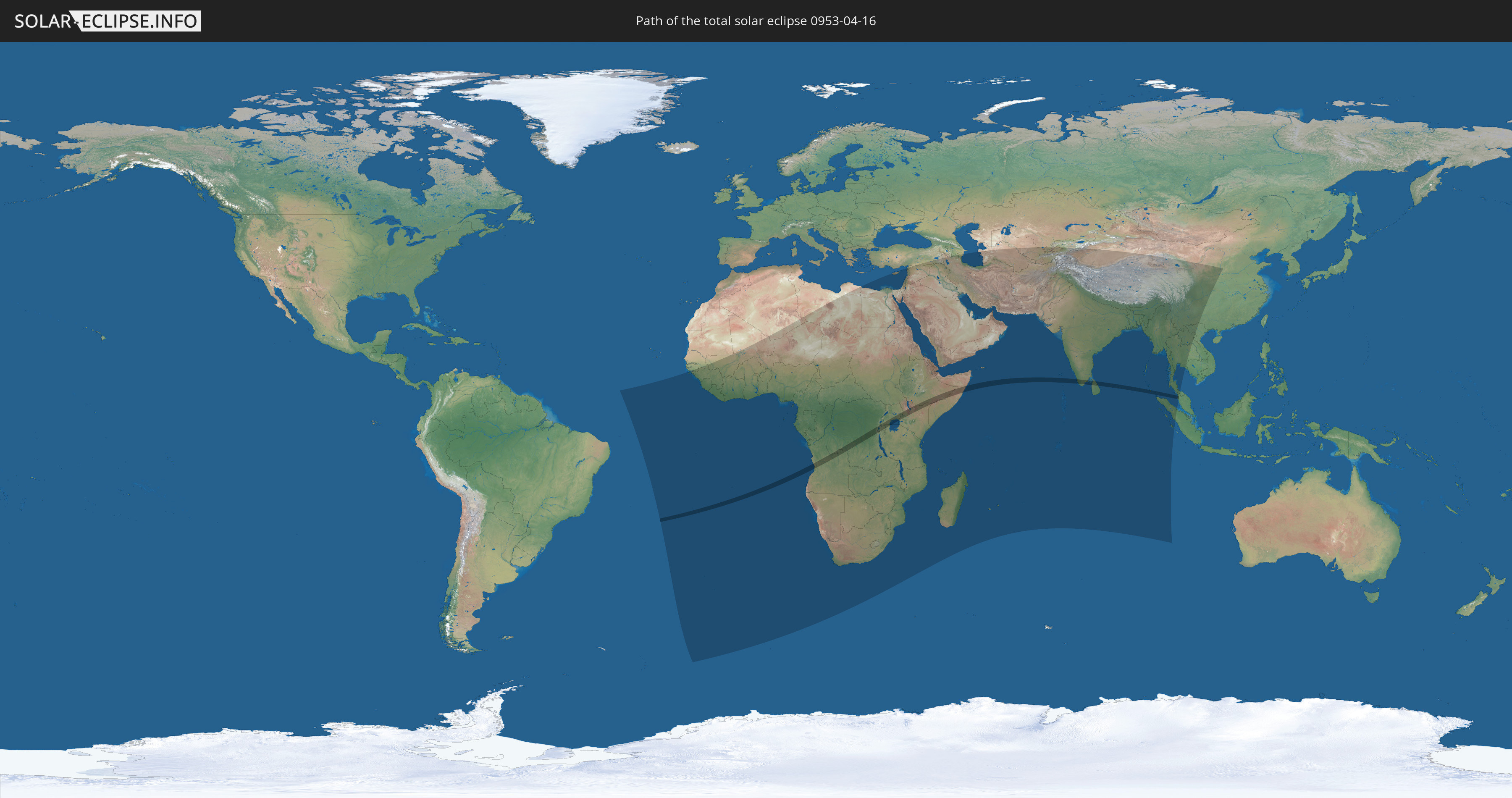
Die Sonnenfinsternis am 04/16/0953 kann man in 94 Ländern als partielle Sonnenfinsternis beobachten.
Der Finsternispfad verläuft durch 12 Länder. Nur in diesen Ländern ist sie als total Sonnenfinsternis zu sehen.
In den folgenden Ländern ist die Sonnenfinsternis total zu sehen
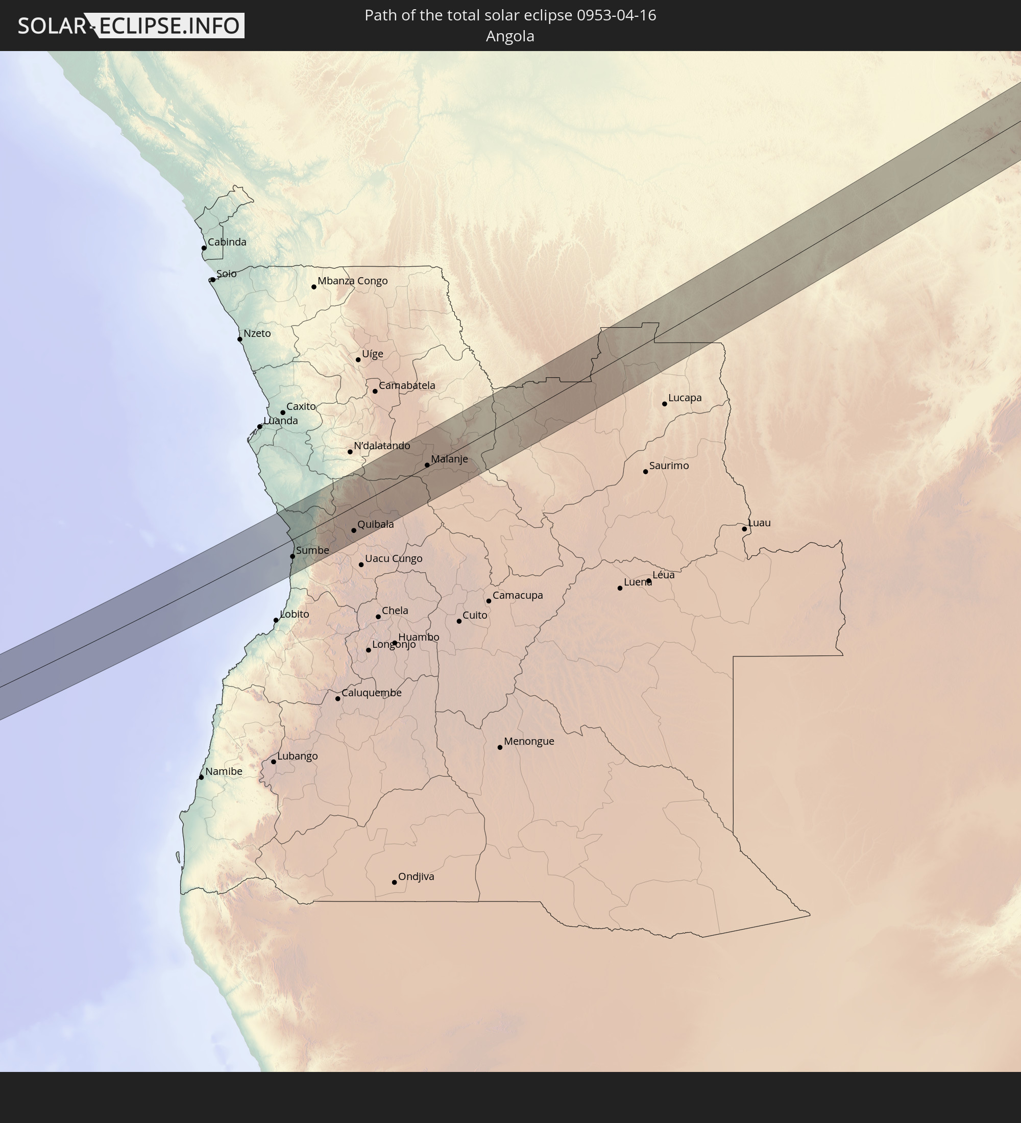 Angola
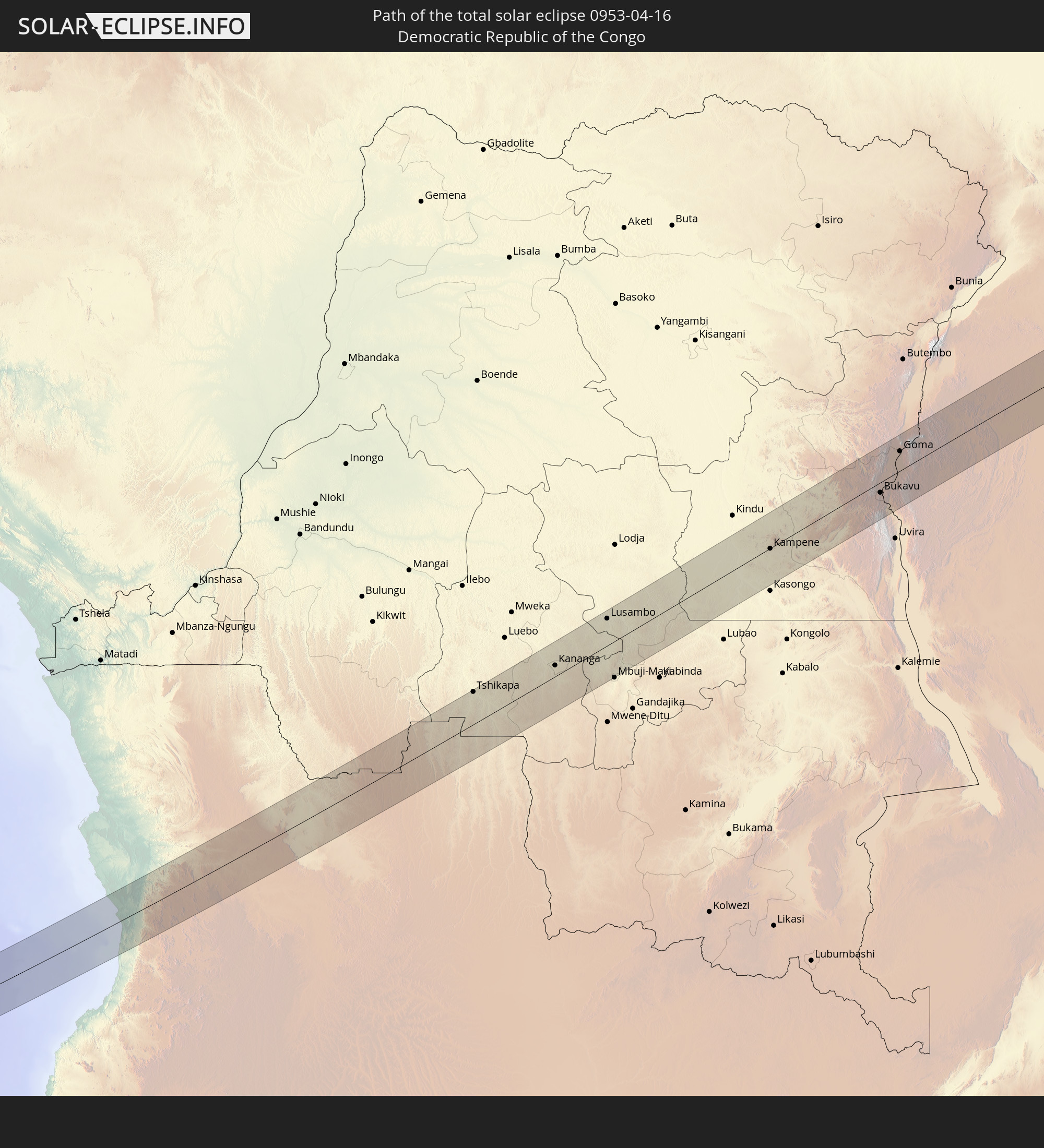 Democratic Republic of the Congo
 Rwanda
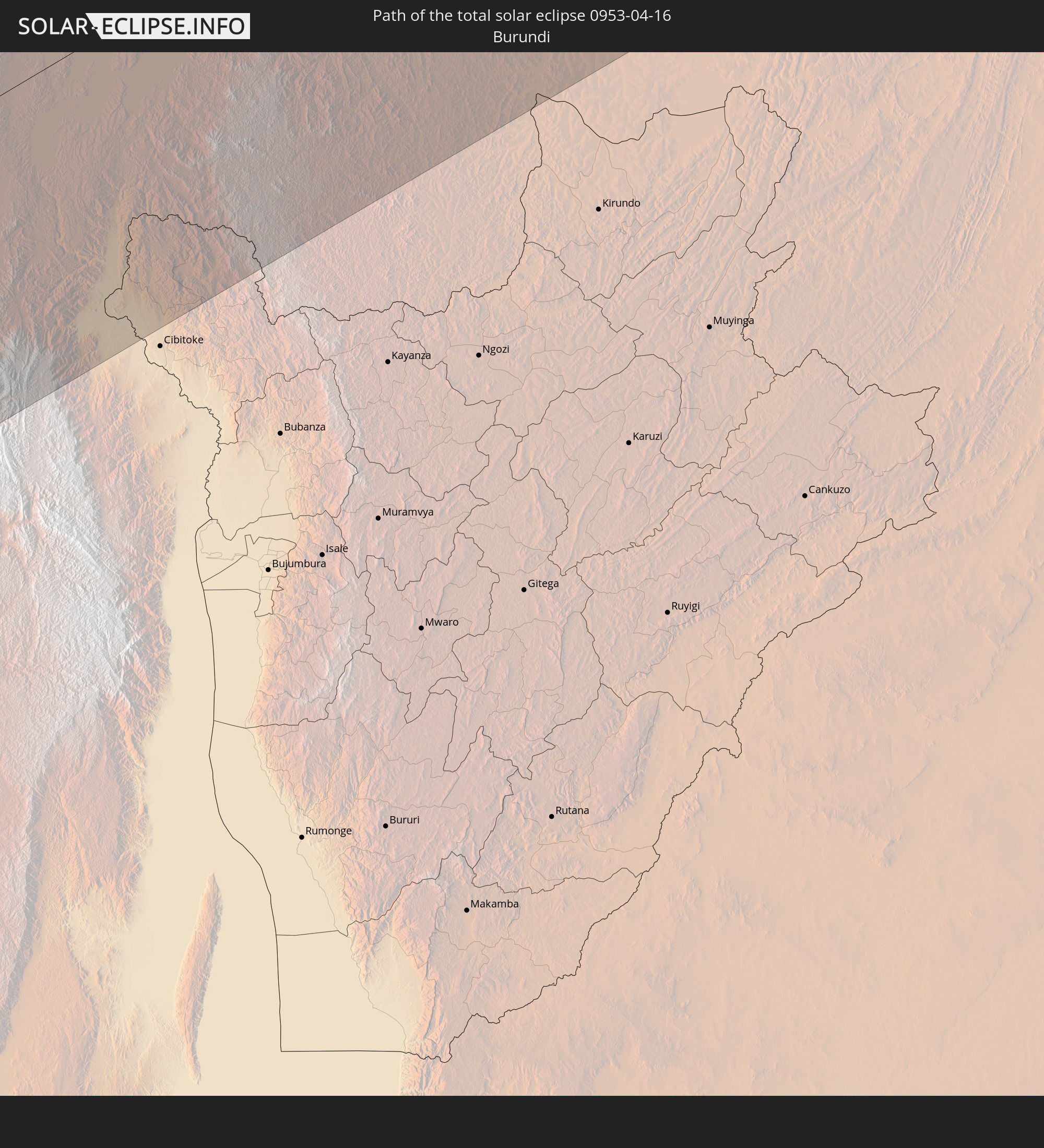 Burundi
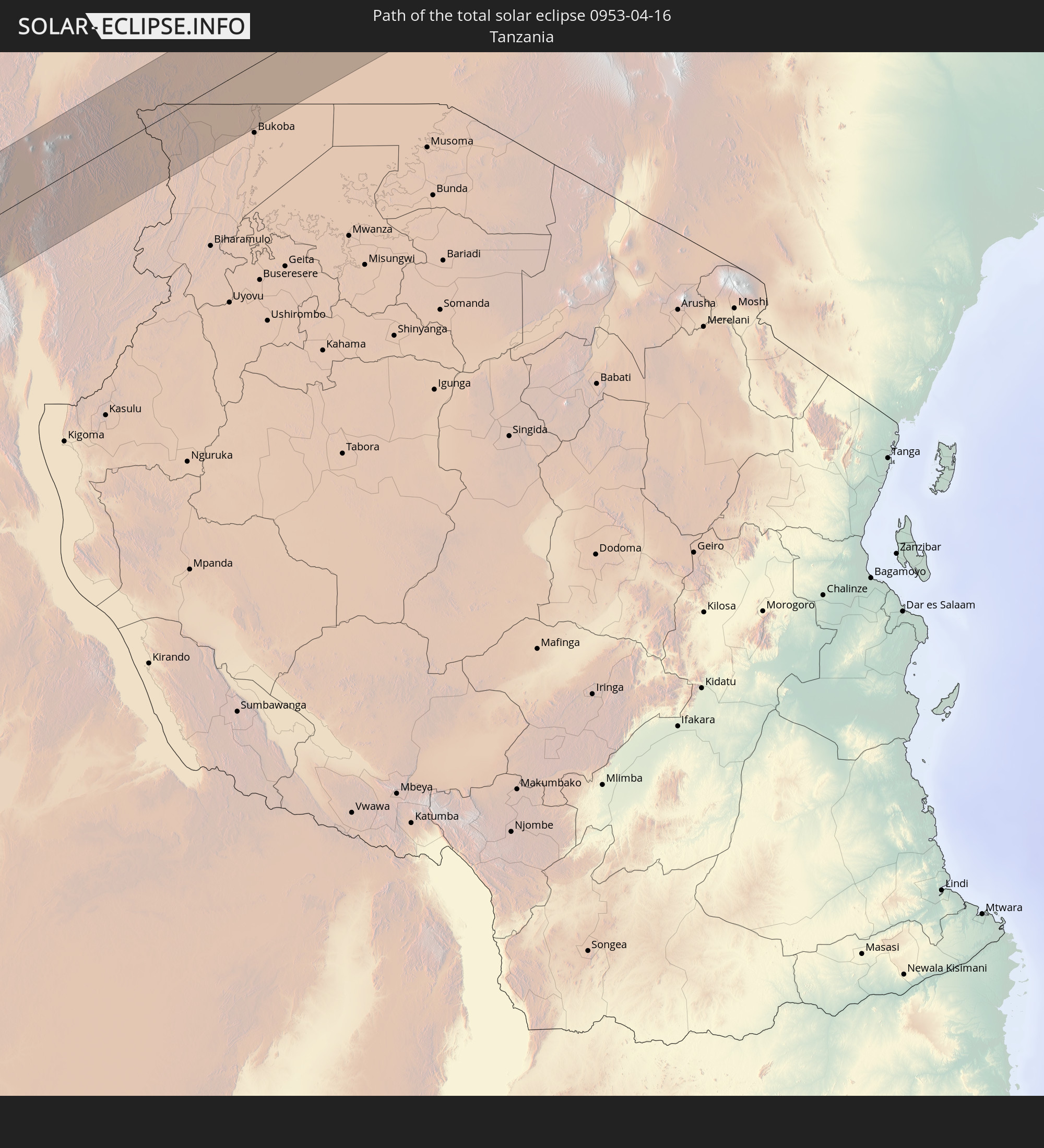 Tanzania
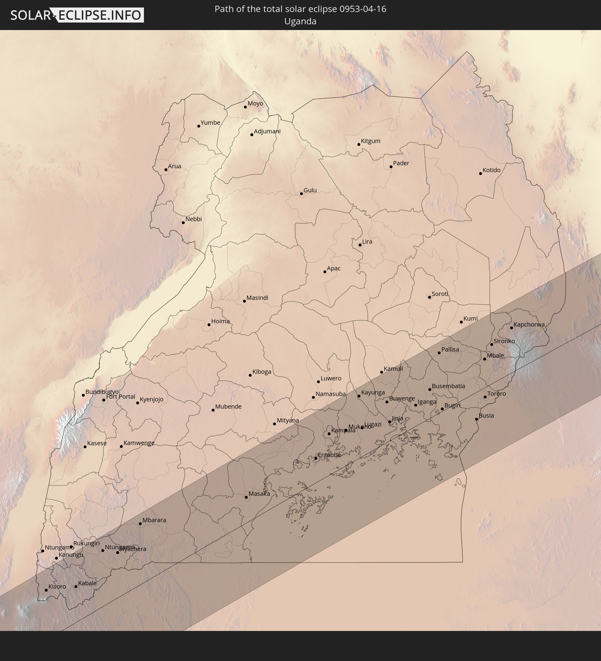 Uganda
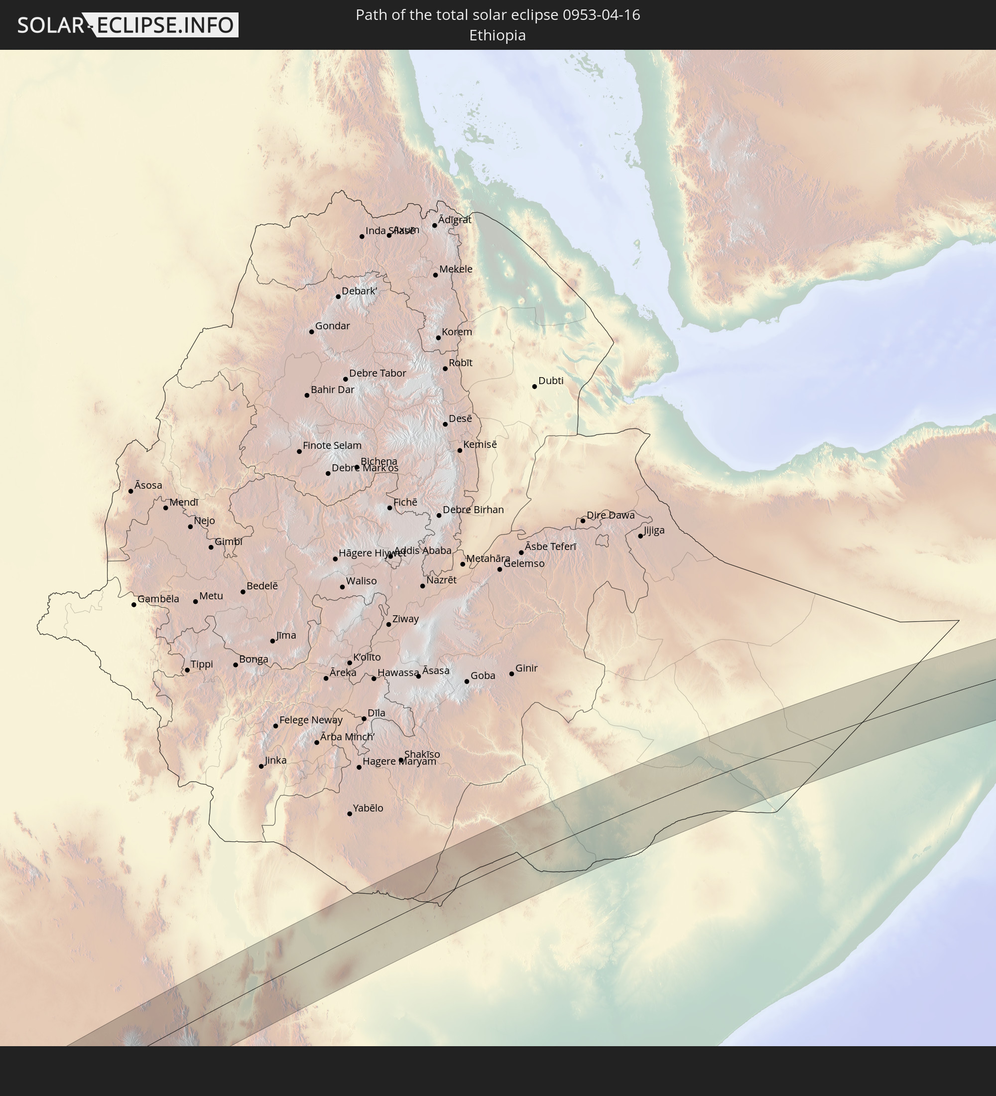 Ethiopia
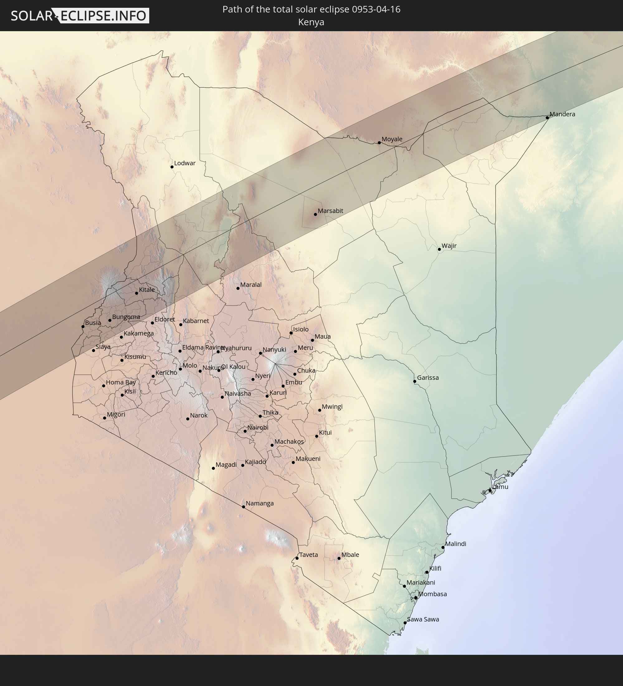 Kenya
Kenya
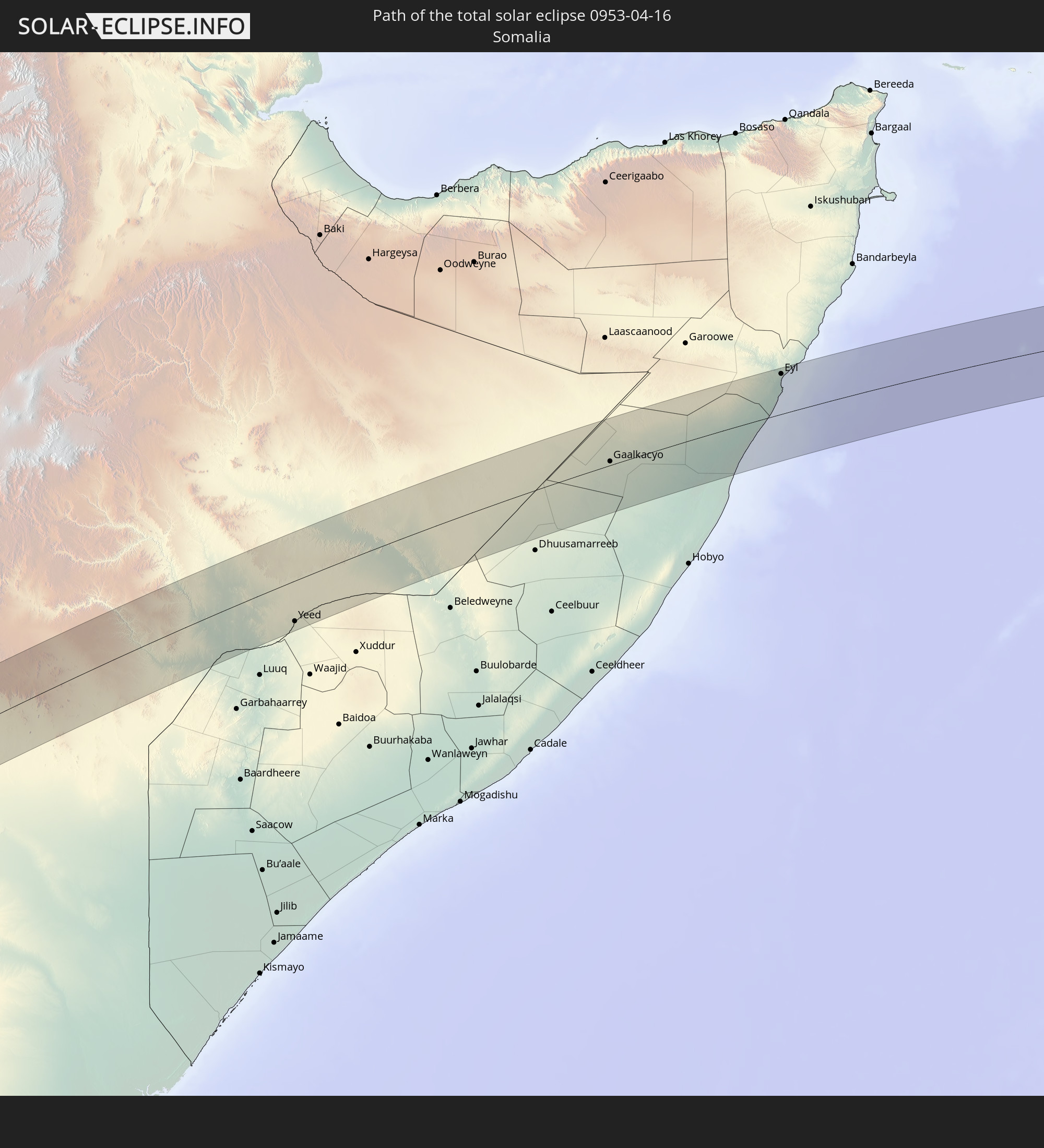 Somalia
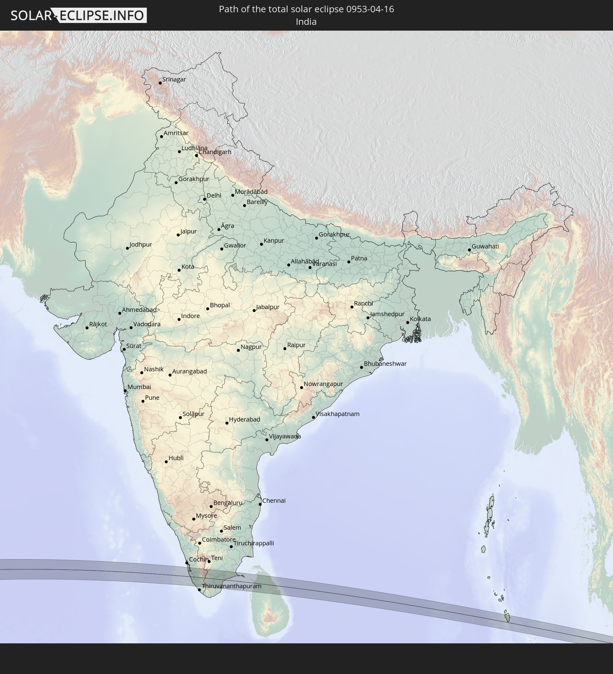 India
India
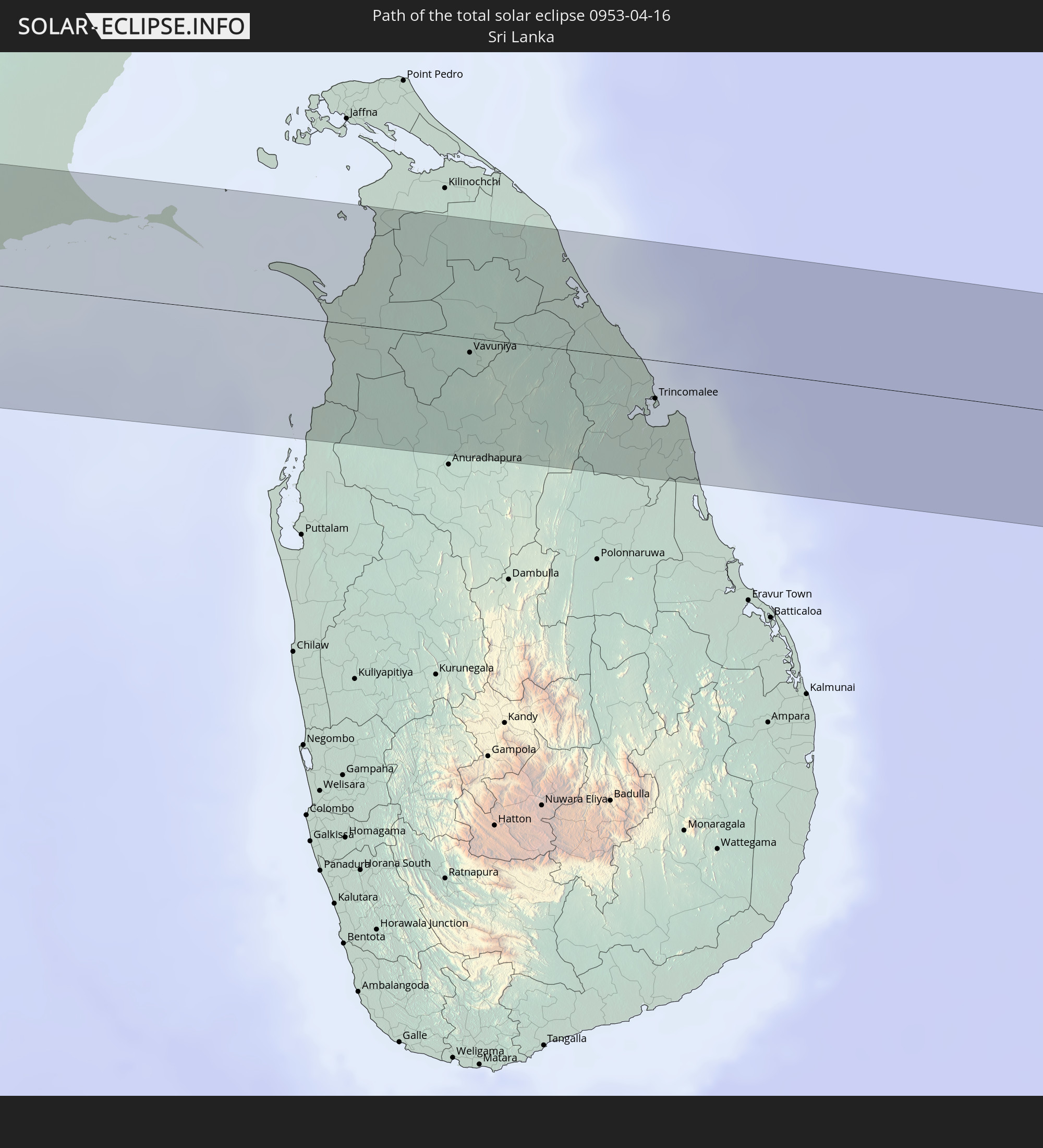 Sri Lanka
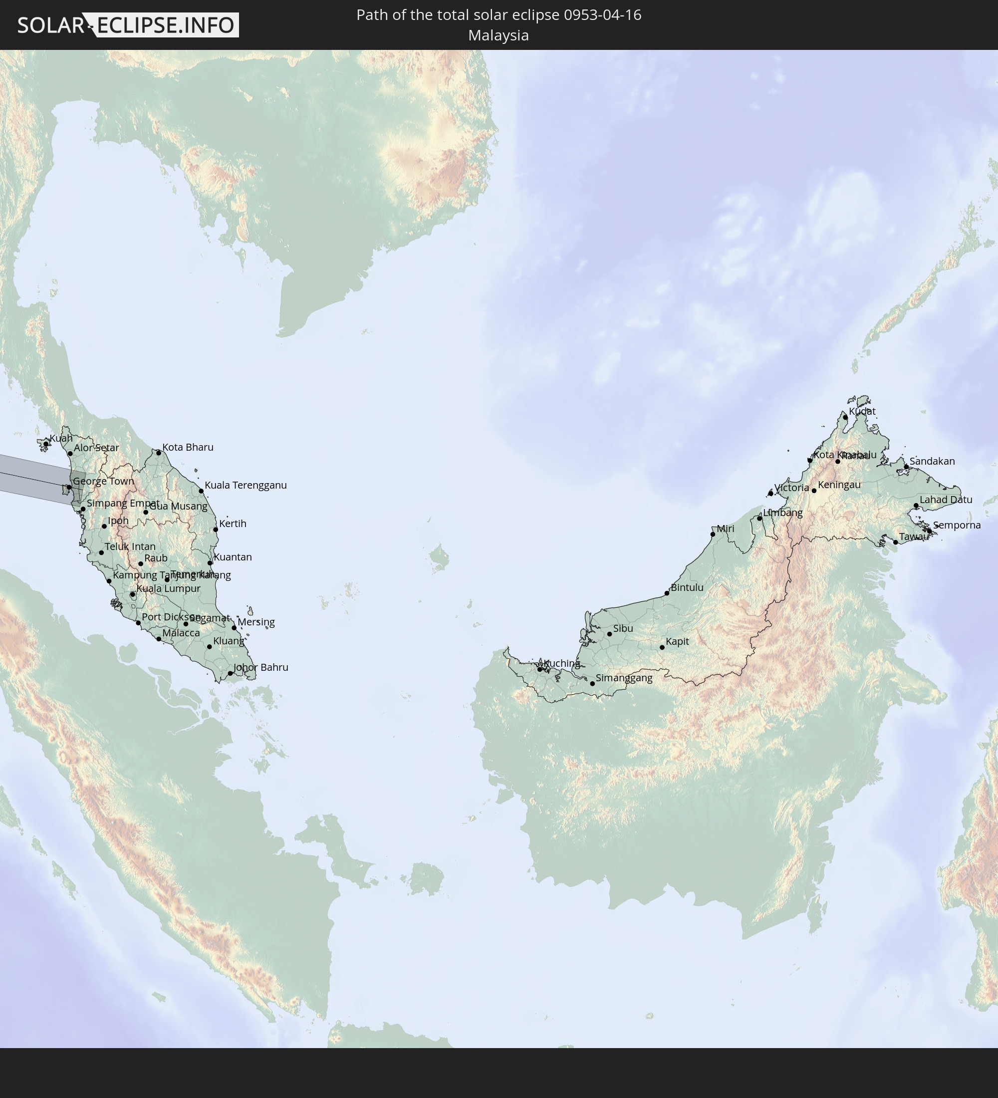 Malaysia
In den folgenden Ländern ist die Sonnenfinsternis partiell zu sehen
 Senegal
 Mauritania
 Guinea-Bissau
 Guinea
 Saint Helena, Ascension and Tristan da Cunha
 Sierra Leone
 Mali
Mali
 Liberia
 Algeria
 Ivory Coast
 Burkina Faso
 Ghana
Ghana
 Togo
Togo
 Niger
Niger
 Benin
Benin
 Nigeria
 Equatorial Guinea
 São Tomé and Príncipe
 Cameroon
 Gabon
Gabon
 Libya
Libya
 Republic of the Congo
 Angola
 Namibia
 Democratic Republic of the Congo
 Chad
Chad
 Central African Republic
 South Africa
 Botswana
 Sudan
Sudan
 Zambia
 Egypt
Egypt
 Zimbabwe
 Turkey
 Lesotho
 Rwanda
 Burundi
 Tanzania
 Uganda
 Mozambique
 Swaziland
 Cyprus
 Malawi
 Ethiopia
 Kenya
Kenya
 State of Palestine
 Israel
 Saudi Arabia
 Jordan
 Lebanon
 Syria
Syria
 Eritrea
 Iraq
Iraq
 French Southern and Antarctic Lands
 Somalia
 Djibouti
 Yemen
Yemen
 Madagascar
 Comoros
 Armenia
 Iran
Iran
 Azerbaijan
 Mayotte
 Seychelles
 Kazakhstan
 Kuwait
 Bahrain
 Qatar
Qatar
 United Arab Emirates
 Oman
Oman
 Turkmenistan
 Réunion
 Uzbekistan
 Mauritius
 Afghanistan
 Pakistan
 Tajikistan
 India
India
 Kyrgyzstan
 British Indian Ocean Territory
 Maldives
 China
China
 Sri Lanka
 Nepal
Nepal
 Bangladesh
 Bhutan
 Myanmar
 Indonesia
 Cocos Islands
 Thailand
 Malaysia
 Laos
Laos
 Vietnam
 Cambodia
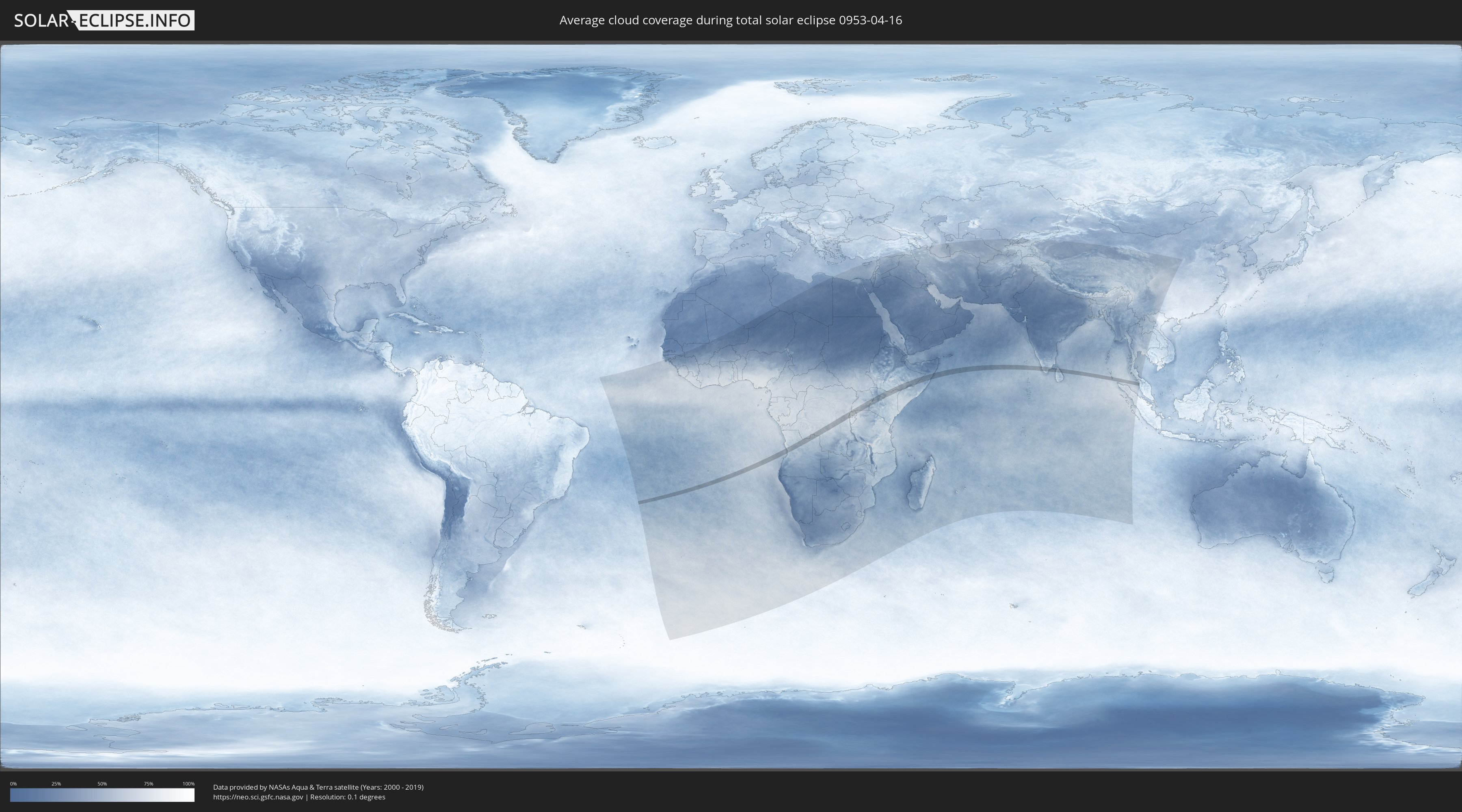
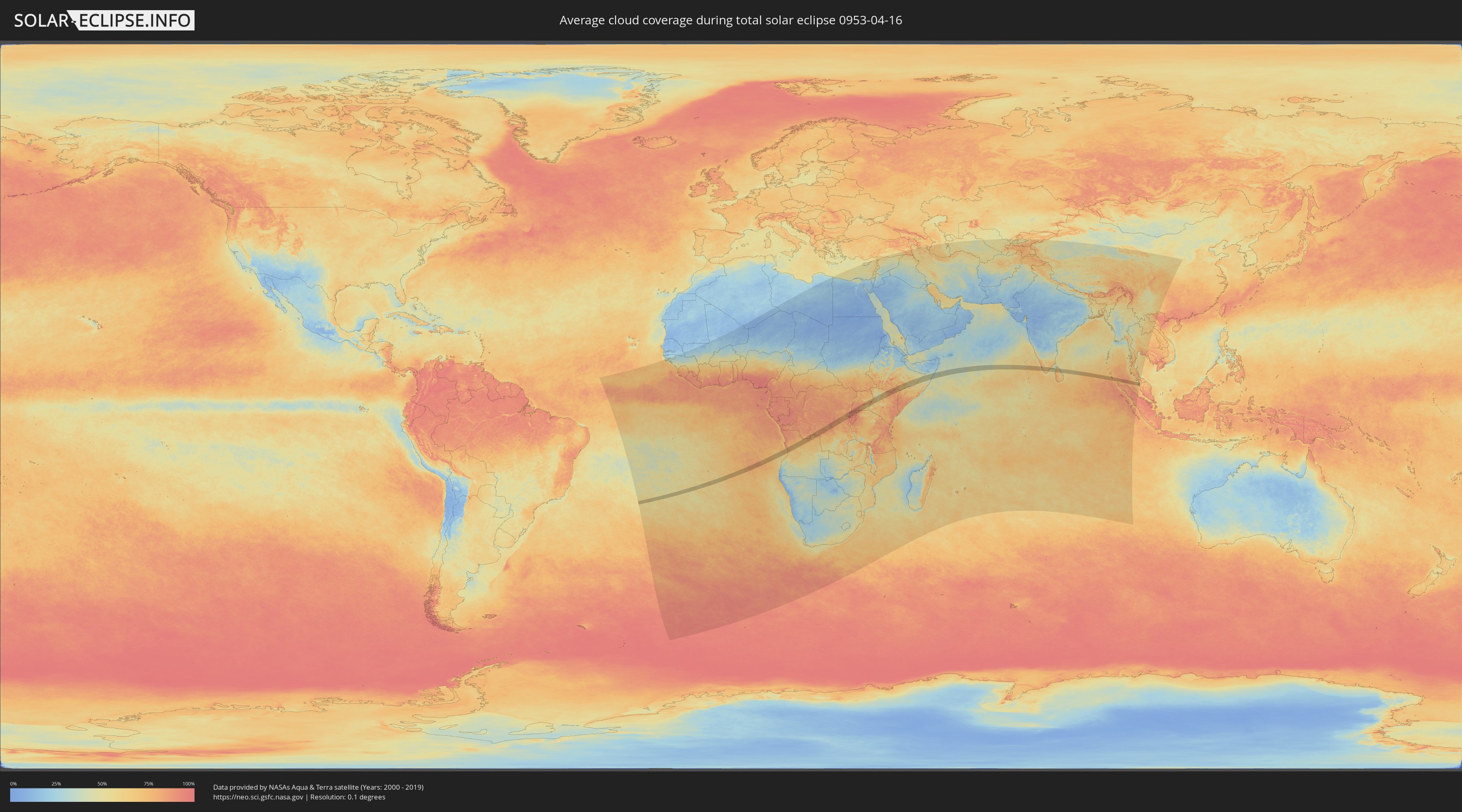
How will be the weather during the total solar eclipse on 04/16/0953?
Where is the best place to see the total solar eclipse of 04/16/0953?
The following maps show the average cloud coverage for the day of the total solar eclipse.
With the help of these maps, it is possible to find the place along the eclipse path, which has the best
chance of a cloudless sky.
Nevertheless, you should consider local circumstances and inform about the weather of your chosen
observation site.
The data is provided by NASAs satellites
AQUA and TERRA.
The cloud maps are averaged over a period of 19 years (2000 - 2019).
Detailed country maps
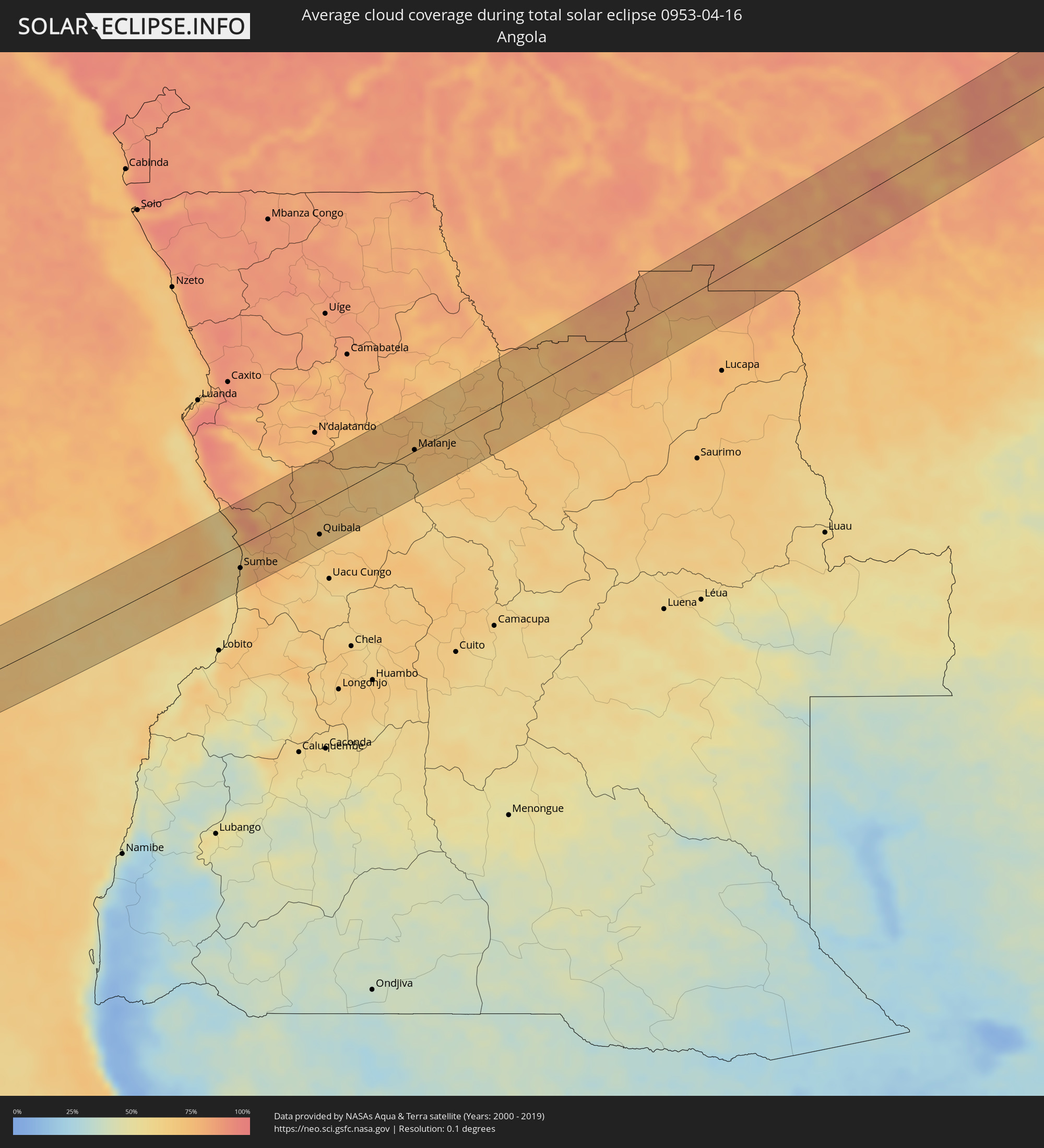 Angola
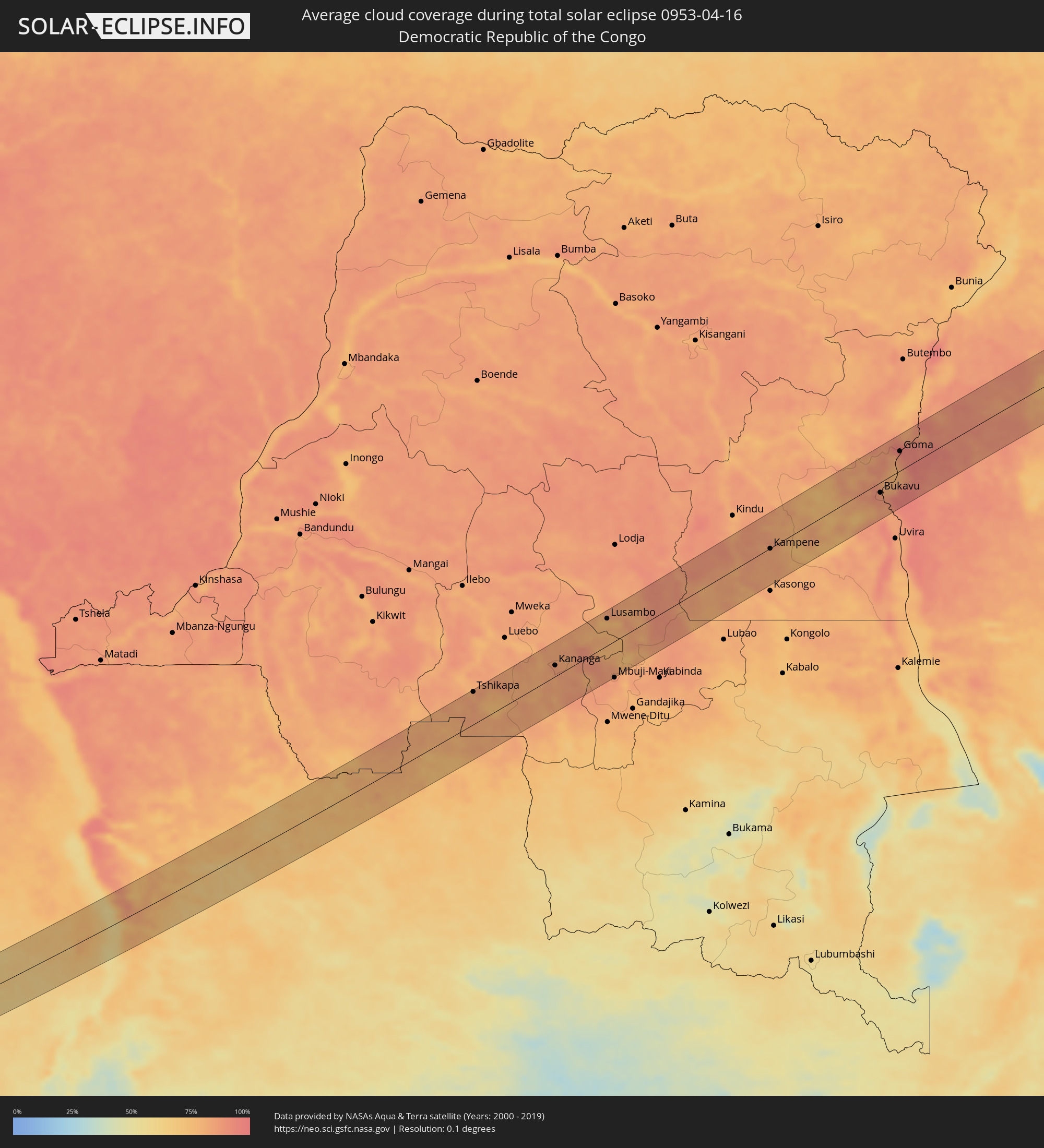 Democratic Republic of the Congo
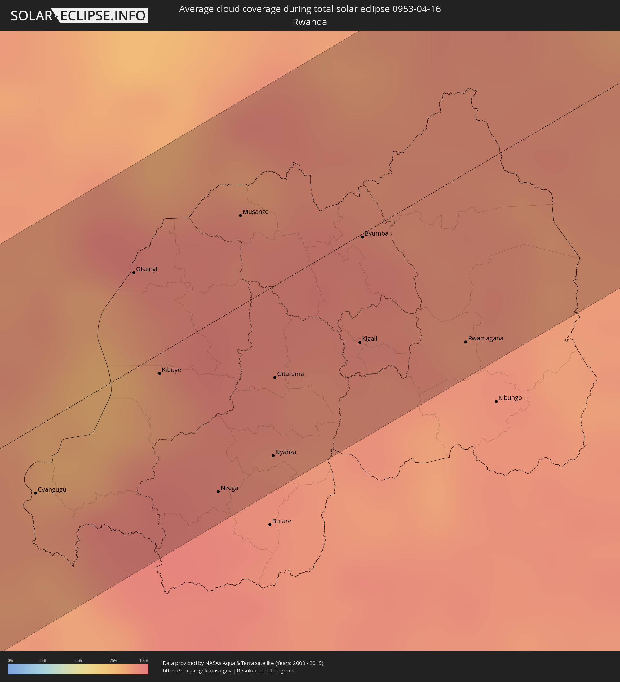 Rwanda
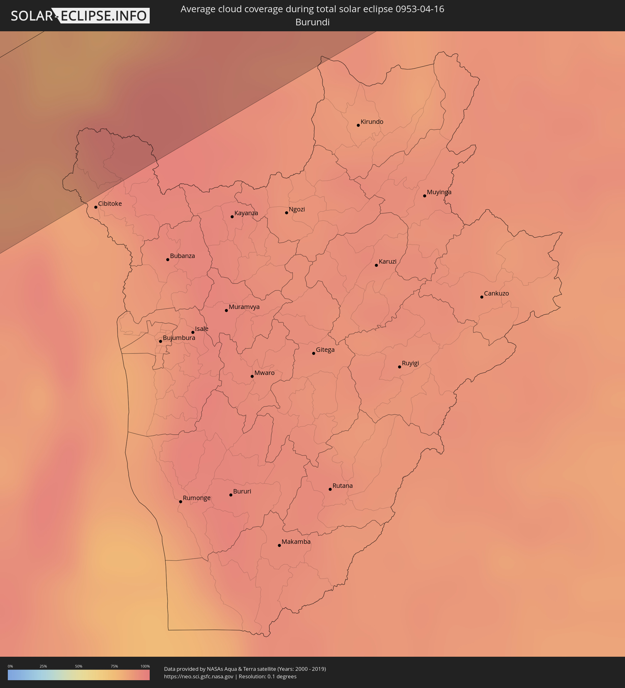 Burundi
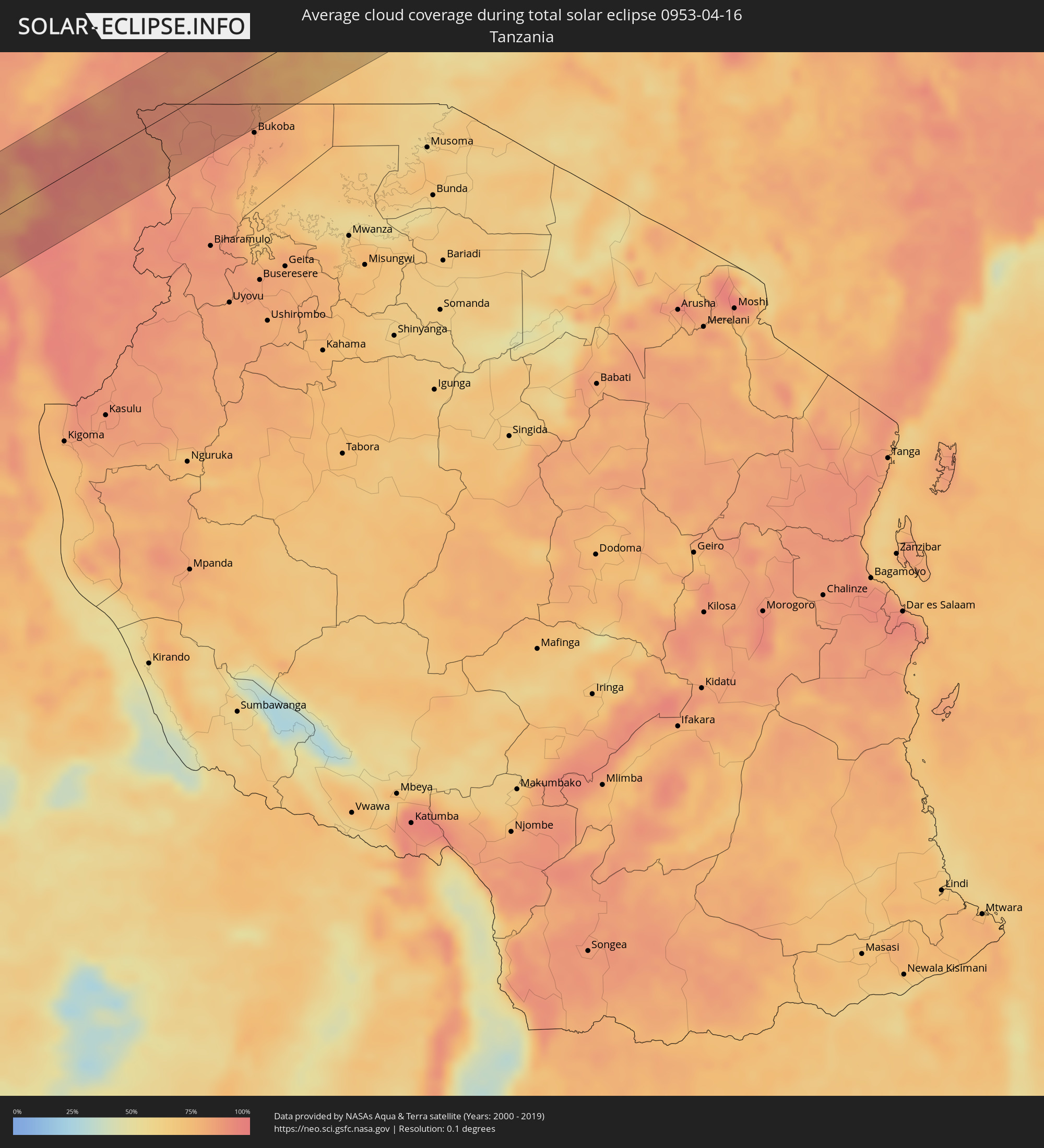 Tanzania
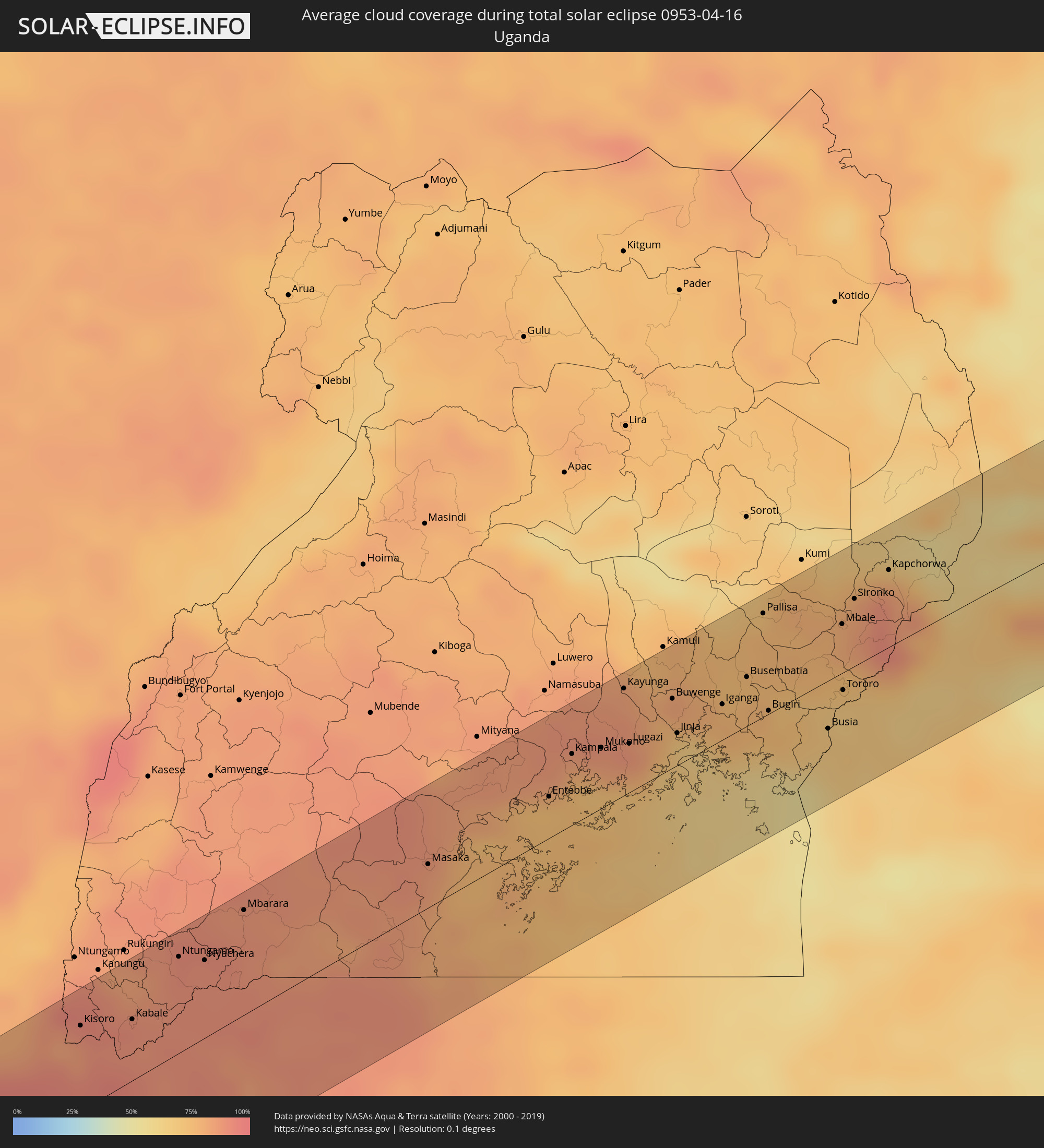 Uganda
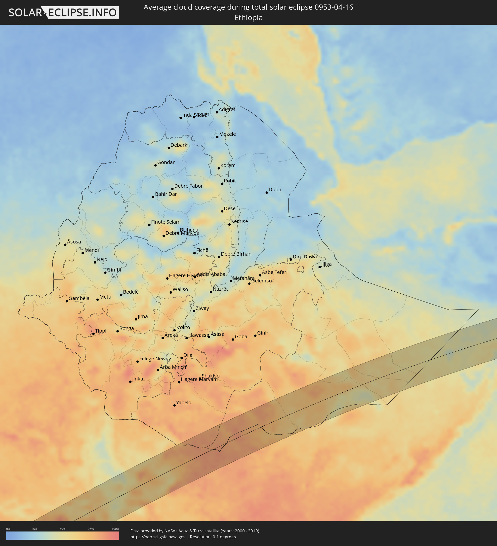 Ethiopia
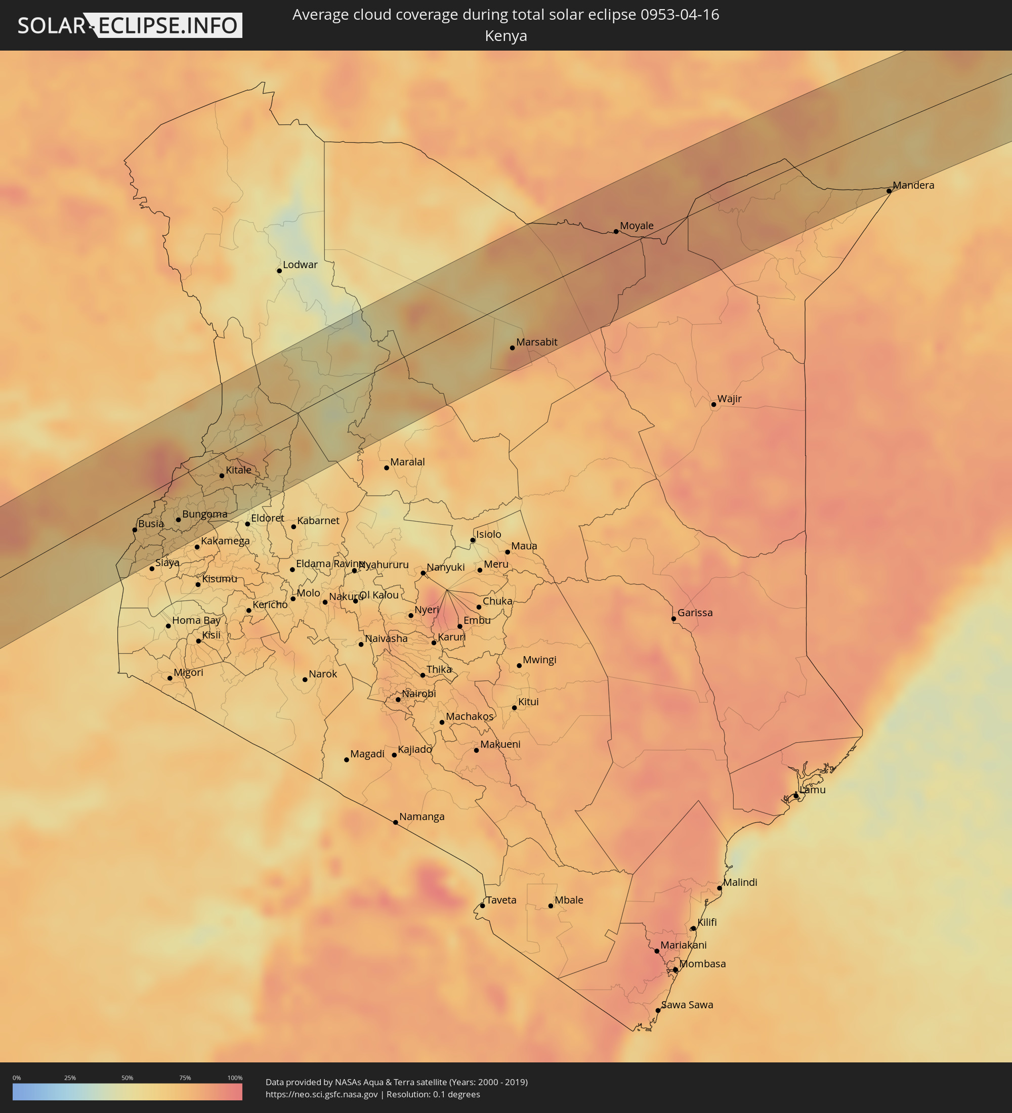 Kenya
Kenya
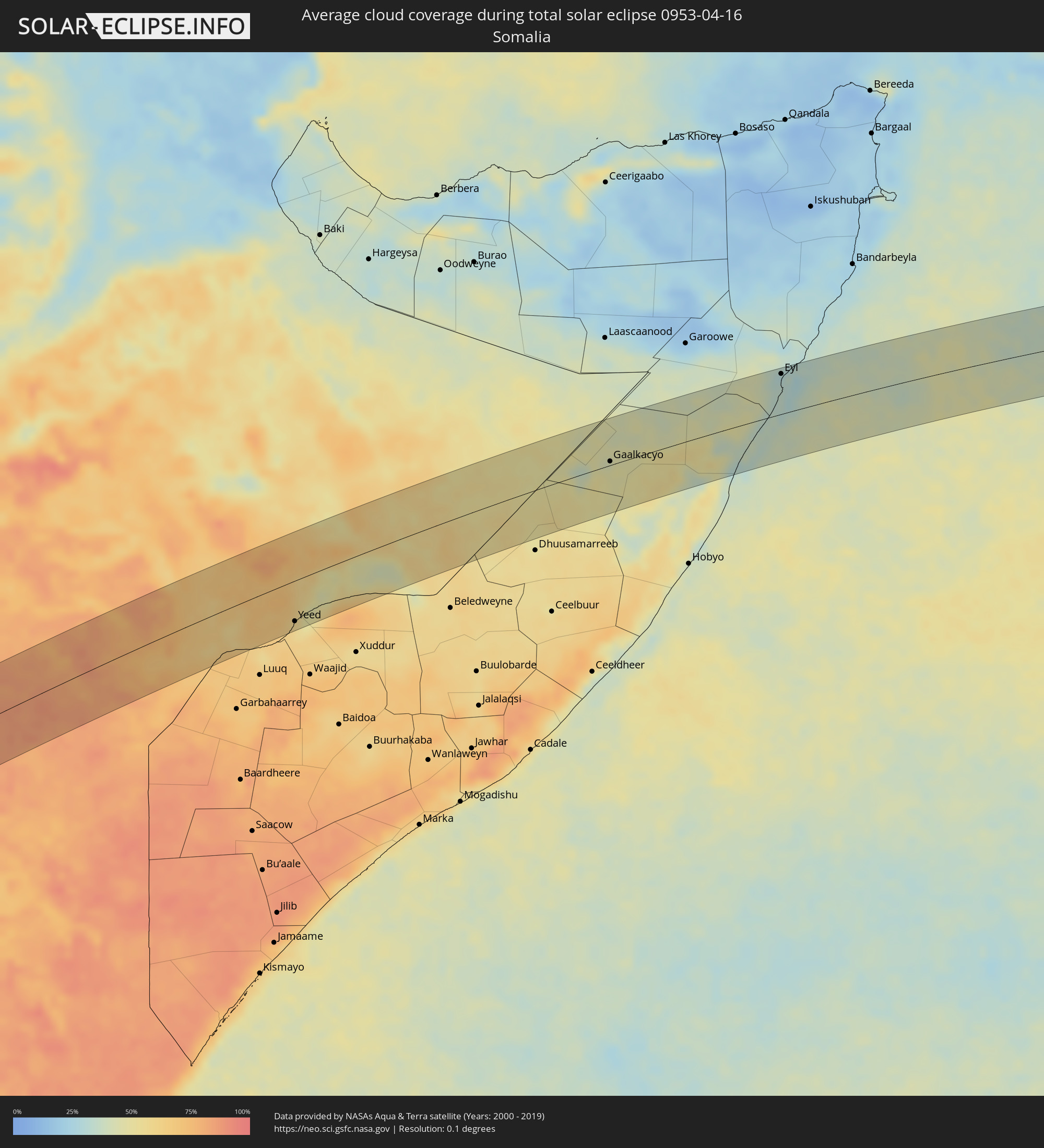 Somalia
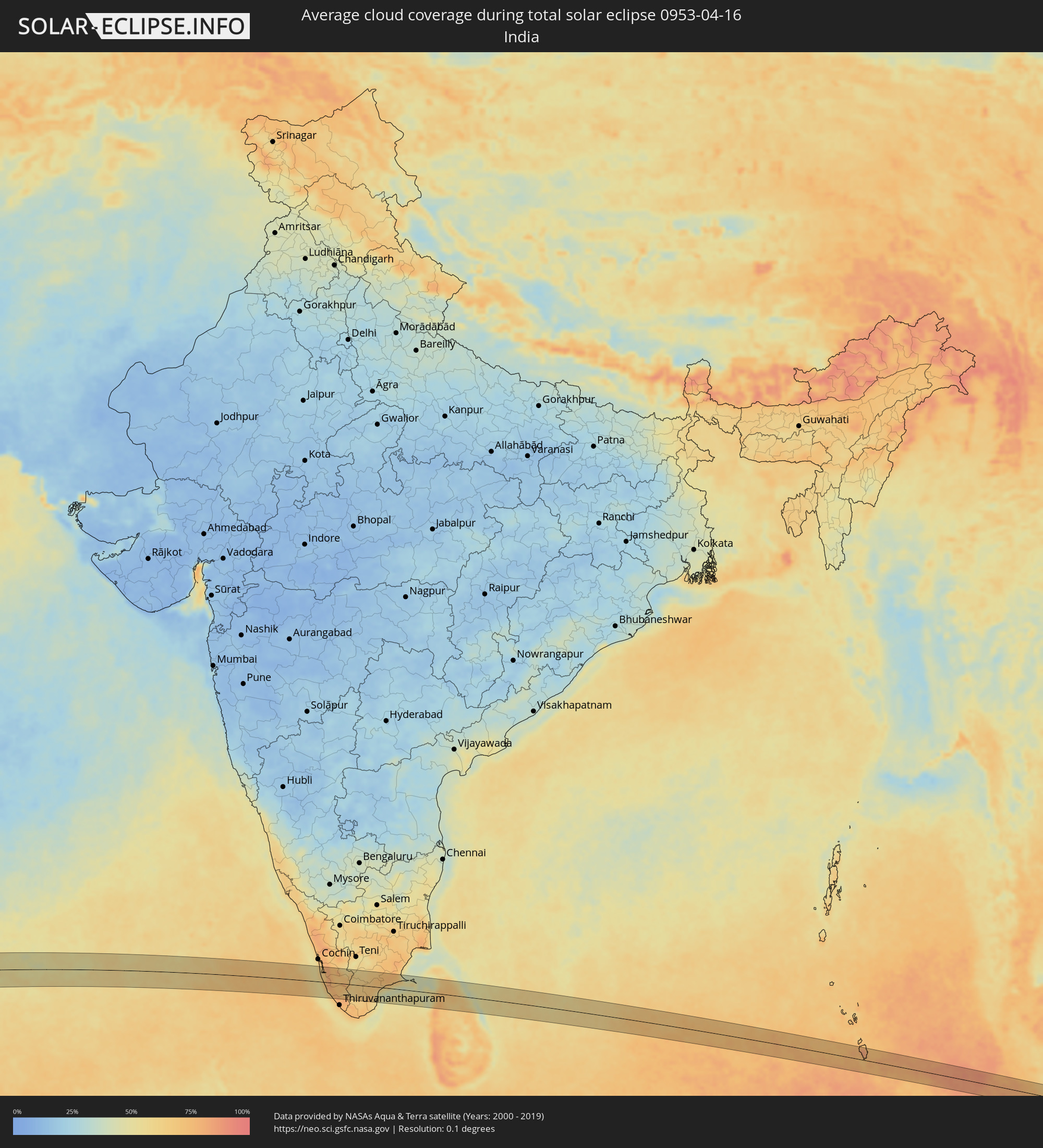 India
India
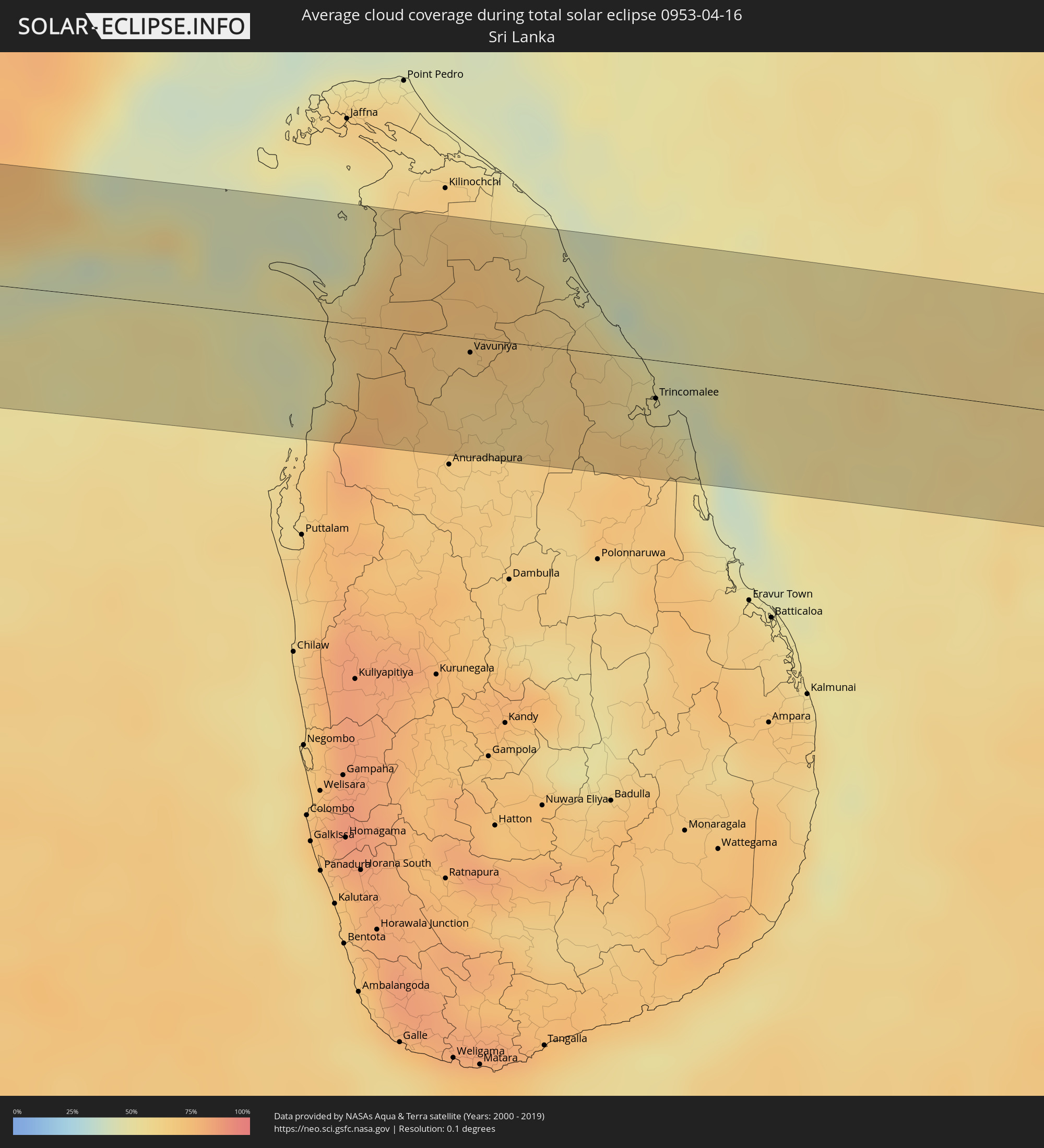 Sri Lanka
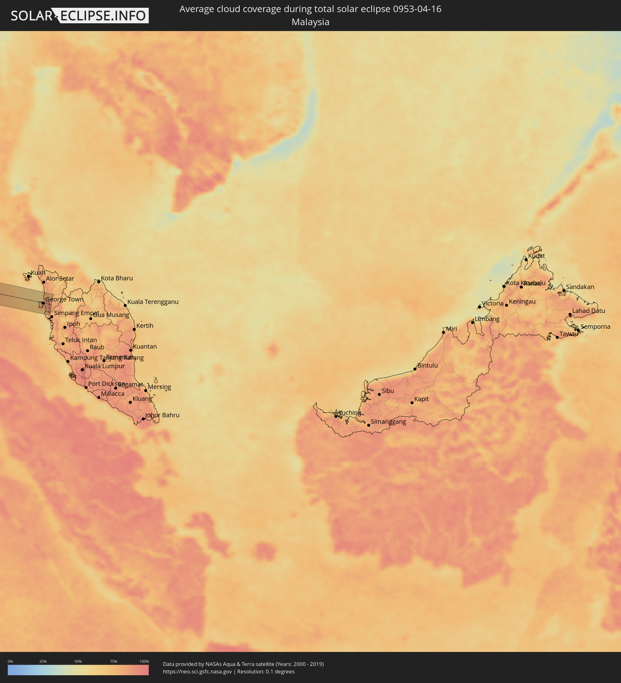 Malaysia
Cities inside the path of the eclipse
The following table shows all locations with a population of more than 5,000 inside the eclipse path. Cities which have more than 100,000 inhabitants are marked bold. A click at the locations opens a detailed map.
| City | Type | Eclipse duration | Local time of max. eclipse | Distance to central line | Ø Cloud coverage |
|
Sumbe, Kwanza Sul
|
total | - | 08:33:56 UTC+00:13 | 32 km | 64% |
|
Quibala, Kwanza Sul
|
total | - | 08:36:12 UTC+00:13 | 44 km | 69% |
|
Malanje, Malanje
|
total | - | 08:39:37 UTC+00:13 | 2 km | 73% |
|
Tshikapa, Kasaï-Occidental
|
total | - | 10:48:13 UTC+02:10 | 61 km | 80% |
|
Kananga, Kasaï-Occidental
|
total | - | 10:52:16 UTC+02:10 | 21 km | 85% |
|
Lusambo, Kasaï-Oriental
|
total | - | 10:55:40 UTC+02:10 | 51 km | 77% |
|
Kampene, Maniema
|
total | - | 11:05:03 UTC+02:10 | 1 km | 82% |
|
Kabare, South Kivu
|
total | - | 11:11:54 UTC+02:10 | 17 km | 88% |
|
Bukavu, South Kivu
|
total | - | 11:12:02 UTC+02:10 | 19 km | 88% |
|
Cyangugu, Western Province
|
total | - | 11:12:13 UTC+02:10 | 22 km | 87% |
|
Sake, Nord Kivu
|
total | - | 11:13:51 UTC+02:10 | 57 km | 83% |
|
Goma, Nord Kivu
|
total | - | 11:14:11 UTC+02:10 | 37 km | 85% |
|
Gisenyi, Western Province
|
total | - | 11:14:13 UTC+02:10 | 33 km | 90% |
|
Kibuye, Western Province
|
total | - | 11:13:57 UTC+02:10 | 7 km | 85% |
|
Nzega, Southern Province
|
total | - | 11:13:54 UTC+02:10 | 59 km | 94% |
|
Musanze, Northern Province
|
total | - | 11:15:30 UTC+02:10 | 31 km | 91% |
|
Nyanza, Southern Province
|
total | - | 11:14:36 UTC+02:10 | 58 km | 90% |
|
Gitarama, Southern Province
|
total | - | 11:15:00 UTC+02:10 | 31 km | 91% |
|
Kabale, Western Region
|
total | - | 11:33:44 UTC+02:27 | 35 km | 89% |
|
Kigali, Kigali
|
total | - | 11:15:58 UTC+02:10 | 37 km | 90% |
|
Byumba, Northern Province
|
total | - | 11:16:32 UTC+02:10 | 1 km | 94% |
|
Ntungamo, Western Region
|
total | - | 11:34:59 UTC+02:27 | 55 km | 89% |
|
Nyachera, Western Region
|
total | - | 11:35:22 UTC+02:27 | 44 km | 89% |
|
Rwamagana, Eastern Province
|
total | - | 11:16:58 UTC+02:10 | 58 km | 89% |
|
Mbarara, Western Region
|
total | - | 11:36:25 UTC+02:27 | 59 km | 90% |
|
Bugene, Kagera
|
total | - | 11:36:19 UTC+02:27 | 63 km | 86% |
|
Nyakahanga, Kagera
|
total | - | 11:36:18 UTC+02:27 | 64 km | 86% |
|
Nsunga, Kagera
|
total | - | 11:37:39 UTC+02:27 | 34 km | 89% |
|
Kyaka, Kagera
|
total | - | 11:37:34 UTC+02:27 | 46 km | 88% |
|
Katoro, Kagera
|
total | - | 11:37:34 UTC+02:27 | 65 km | 85% |
|
Masaka, Central Region
|
total | - | 11:39:45 UTC+02:27 | 25 km | 86% |
|
Entebbe, Central Region
|
total | - | 11:42:18 UTC+02:27 | 24 km | 73% |
|
Wakiso, Central Region
|
total | - | 11:42:50 UTC+02:27 | 56 km | 87% |
|
Kampala, Central Region
|
total | - | 11:43:02 UTC+02:27 | 41 km | 79% |
|
Kireka, Central Region
|
total | - | 11:43:16 UTC+02:27 | 40 km | 79% |
|
Mukono, Central Region
|
total | - | 11:43:34 UTC+02:27 | 35 km | 86% |
|
Kayunga, Central Region
|
total | - | 11:44:28 UTC+02:27 | 61 km | 84% |
|
Lugazi, Central Region
|
total | - | 11:44:04 UTC+02:27 | 28 km | 88% |
|
Jinja, Eastern Region
|
total | - | 11:44:57 UTC+02:27 | 18 km | 67% |
|
Iganga, Eastern Region
|
total | - | 11:45:57 UTC+02:27 | 20 km | 77% |
|
Busembatia, Eastern Region
|
total | - | 11:46:35 UTC+02:27 | 28 km | 74% |
|
Pallisa, Eastern Region
|
total | - | 11:47:25 UTC+02:27 | 59 km | 76% |
|
Bugiri, Eastern Region
|
total | - | 11:46:39 UTC+02:27 | 2 km | 76% |
|
Port Bunyala, Busia
|
total | - | 11:46:37 UTC+02:27 | 57 km | 55% |
|
Luanda, Busia
|
total | - | 11:47:10 UTC+02:27 | 42 km | 65% |
|
Busia, Eastern Region
|
total | - | 11:47:30 UTC+02:27 | 28 km | 69% |
|
Busia, Busia
|
total | - | 11:47:32 UTC+02:27 | 29 km | 69% |
|
Mbale, Eastern Region
|
total | - | 11:48:38 UTC+02:27 | 28 km | 81% |
|
Tororo, Eastern Region
|
total | - | 11:48:05 UTC+02:27 | 10 km | 67% |
|
Bondo, Siaya
|
total | - | 11:47:40 UTC+02:27 | 59 km | 66% |
|
Malaba, Busia
|
total | - | 11:48:16 UTC+02:27 | 21 km | 68% |
|
Lugulu, Busia
|
total | - | 11:47:59 UTC+02:27 | 46 km | 67% |
|
Mumias, Kakamega
|
total | - | 11:48:25 UTC+02:27 | 62 km | 67% |
|
Bungoma, Bungoma
|
total | - | 11:48:58 UTC+02:27 | 43 km | 64% |
|
Webuye, Bungoma
|
total | - | 11:49:38 UTC+02:27 | 50 km | 67% |
|
Kitale, Trans Nzoia
|
total | - | 11:50:54 UTC+02:27 | 23 km | 70% |
|
Kapenguria, West Pokot
|
total | - | 11:51:33 UTC+02:27 | 8 km | 73% |
|
Kapsowar, Elegeyo-Marakwet
|
total | - | 11:52:27 UTC+02:27 | 56 km | 59% |
|
Marsabit, Marsabit
|
total | - | 12:01:31 UTC+02:27 | 48 km | 84% |
|
Moyale, Marsabit
|
total | - | 12:06:22 UTC+02:27 | 18 km | 85% |
|
Mandera, Mandera
|
total | - | 12:15:15 UTC+02:27 | 70 km | 69% |
|
Yeed, Bakool
|
total | - | 12:19:34 UTC+02:27 | 58 km | 59% |
|
Gaalkacyo, Mudug
|
total | - | 12:35:04 UTC+02:27 | 6 km | 42% |
|
Eyl, Nugaal
|
total | - | 12:42:58 UTC+02:27 | 60 km | 30% |
|
Alleppey, Kerala
|
total | - | 16:29:06 UTC+05:21 | 29 km | 59% |
|
Cherthala, Kerala
|
total | - | 16:29:09 UTC+05:21 | 50 km | 63% |
|
Kāyankulam, Kerala
|
total | - | 16:29:14 UTC+05:21 | 5 km | 69% |
|
Kottayam, Kerala
|
total | - | 16:29:20 UTC+05:21 | 41 km | 71% |
|
Tiruvalla, Kerala
|
total | - | 16:29:21 UTC+05:21 | 19 km | 80% |
|
Kollam, Kerala
|
total | - | 16:29:17 UTC+05:21 | 36 km | 62% |
|
Varkala, Kerala
|
total | - | 16:29:24 UTC+05:21 | 51 km | 56% |
|
Pathanāmthitta, Kerala
|
total | - | 16:29:34 UTC+05:21 | 8 km | 72% |
|
Punalūr, Kerala
|
total | - | 16:29:41 UTC+05:21 | 17 km | 73% |
|
Kadayanallur, Tamil Nadu
|
total | - | 16:30:07 UTC+05:21 | 7 km | 61% |
|
Ambasamudram, Tamil Nadu
|
total | - | 16:30:10 UTC+05:21 | 46 km | 63% |
|
Rajapalaiyam, Tamil Nadu
|
total | - | 16:30:24 UTC+05:21 | 37 km | 61% |
|
Tirunelveli, Tamil Nadu
|
total | - | 16:30:25 UTC+05:21 | 42 km | 66% |
|
Sivakasi, Tamil Nadu
|
total | - | 16:30:39 UTC+05:21 | 39 km | 63% |
|
Kovilpatti, Tamil Nadu
|
total | - | 16:30:41 UTC+05:21 | 9 km | 68% |
|
Sattur, Tamil Nadu
|
total | - | 16:30:46 UTC+05:21 | 30 km | 64% |
|
Aruppukkottai, Tamil Nadu
|
total | - | 16:30:57 UTC+05:21 | 49 km | 69% |
|
Keelakarai, Tamil Nadu
|
total | - | 16:31:35 UTC+05:21 | 26 km | 45% |
|
Ramanathapuram, Tamil Nadu
|
total | - | 16:31:39 UTC+05:21 | 42 km | 68% |
|
Rameswaram, Tamil Nadu
|
total | - | 16:32:05 UTC+05:21 | 38 km | 59% |
|
Vavuniya, Northern Province
|
total | - | 16:31:27 UTC+05:19 | 6 km | 67% |
|
Trincomalee, Eastern Province
|
total | - | 16:32:03 UTC+05:19 | 17 km | 54% |
|
Telaga Batu, Penang
|
total | - | 18:15:19 UTC+06:55 | 2 km | 75% |
|
Kampung Sungai Ara, Penang
|
total | - | 18:15:18 UTC+06:55 | 13 km | 69% |
|
Tanjung Tokong, Penang
|
total | - | 18:15:19 UTC+06:55 | 3 km | 76% |
|
George Town, Penang
|
total | - | 18:15:19 UTC+06:55 | 18 km | 83% |
|
Butterworth, Penang
|
total | - | 18:15:19 UTC+06:55 | 15 km | 81% |
|
Permatang Kuching, Penang
|
total | - | 18:15:19 UTC+06:55 | 15 km | 83% |
|
Perai, Penang
|
total | - | 18:15:19 UTC+06:55 | 13 km | 81% |
|
Kepala Batas, Penang
|
total | - | 18:15:20 UTC+06:55 | 16 km | 83% |
|
Juru, Penang
|
total | - | 18:15:18 UTC+06:55 | 11 km | 71% |
|
Bukit Mertajam, Penang
|
total | - | 18:15:19 UTC+06:55 | 5 km | 90% |
|
Nibong Tebal, Penang
|
total | - | 18:15:17 UTC+06:55 | 25 km | 85% |
|
Sungai Petani, Kedah
|
total | - | 18:15:21 UTC+06:55 | 28 km | 87% |
|
Parit Buntar, Perak
|
total | - | 18:15:17 UTC+06:55 | 29 km | 81% |
|
Tasek Glugor, Penang
|
total | - | 18:15:20 UTC+06:55 | 10 km | 89% |
|
Bedong, Kedah
|
total | - | 18:15:21 UTC+06:55 | 37 km | 84% |
|
Kulim, Kedah
|
total | - | 18:15:19 UTC+06:55 | 2 km | 88% |