Total solar eclipse of 01/02/0987
| Day of week: | Tuesday |
| Maximum duration of eclipse: | 02m37s |
| Maximum width of eclipse path: | 257 km |
| Saros cycle: | 115 |
| Coverage: | 100% |
| Magnitude: | 1.0323 |
| Gamma: | 0.9056 |
Wo kann man die Sonnenfinsternis vom 01/02/0987 sehen?
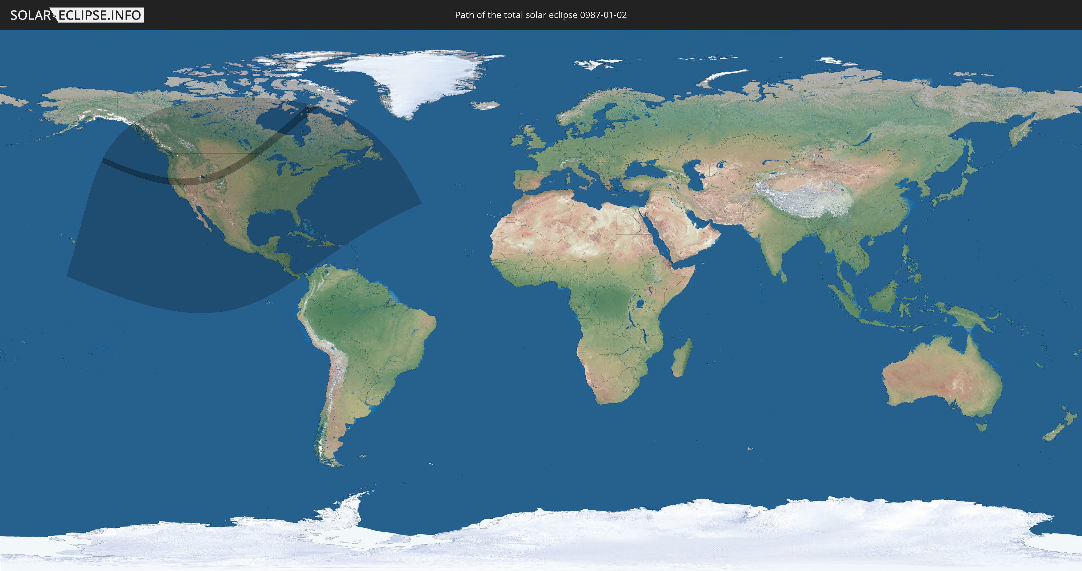
Die Sonnenfinsternis am 01/02/0987 kann man in 24 Ländern als partielle Sonnenfinsternis beobachten.
Der Finsternispfad verläuft durch 2 Länder. Nur in diesen Ländern ist sie als total Sonnenfinsternis zu sehen.
In den folgenden Ländern ist die Sonnenfinsternis total zu sehen
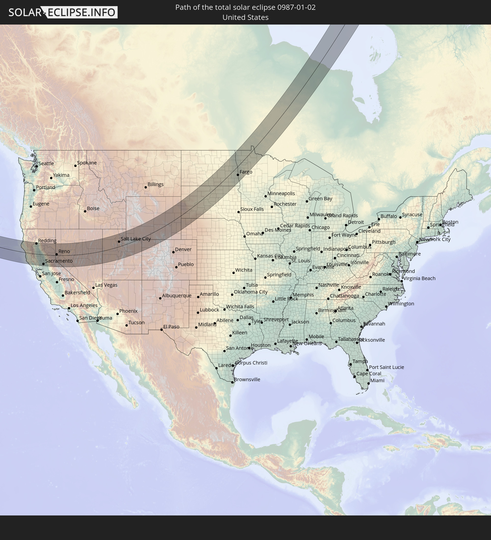 United States
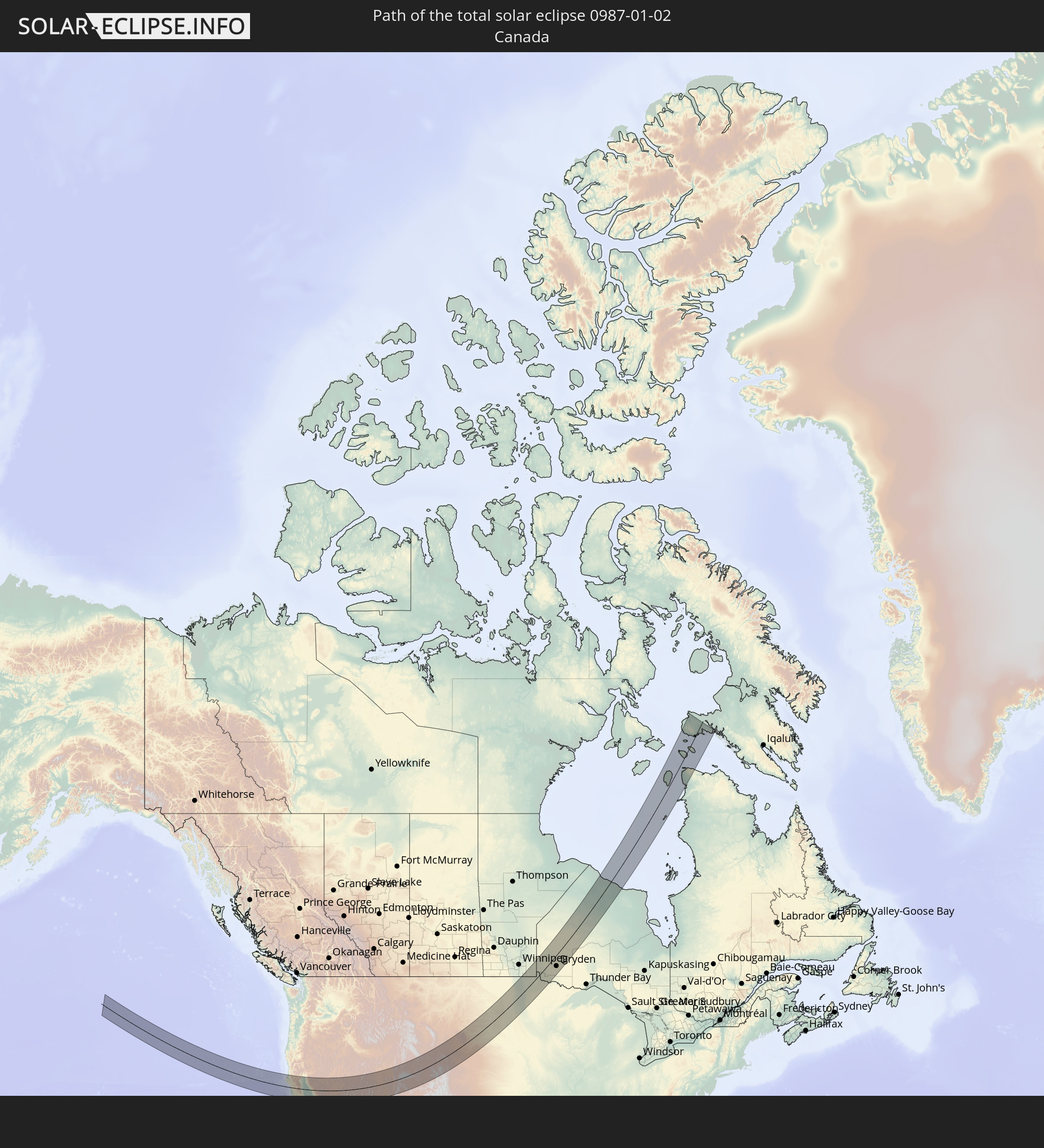 Canada
In den folgenden Ländern ist die Sonnenfinsternis partiell zu sehen
 United States
 United States Minor Outlying Islands
 Canada
 Mexico
 Greenland
 Guatemala
 Ecuador
 El Salvador
 Honduras
 Belize
 Nicaragua
 Costa Rica
 Cuba
Cuba
 Panama
 Colombia
 Cayman Islands
 The Bahamas
 Jamaica
 Haiti
Haiti
 Turks and Caicos Islands
 Dominican Republic
 Puerto Rico
 Bermuda
 Saint Pierre and Miquelon
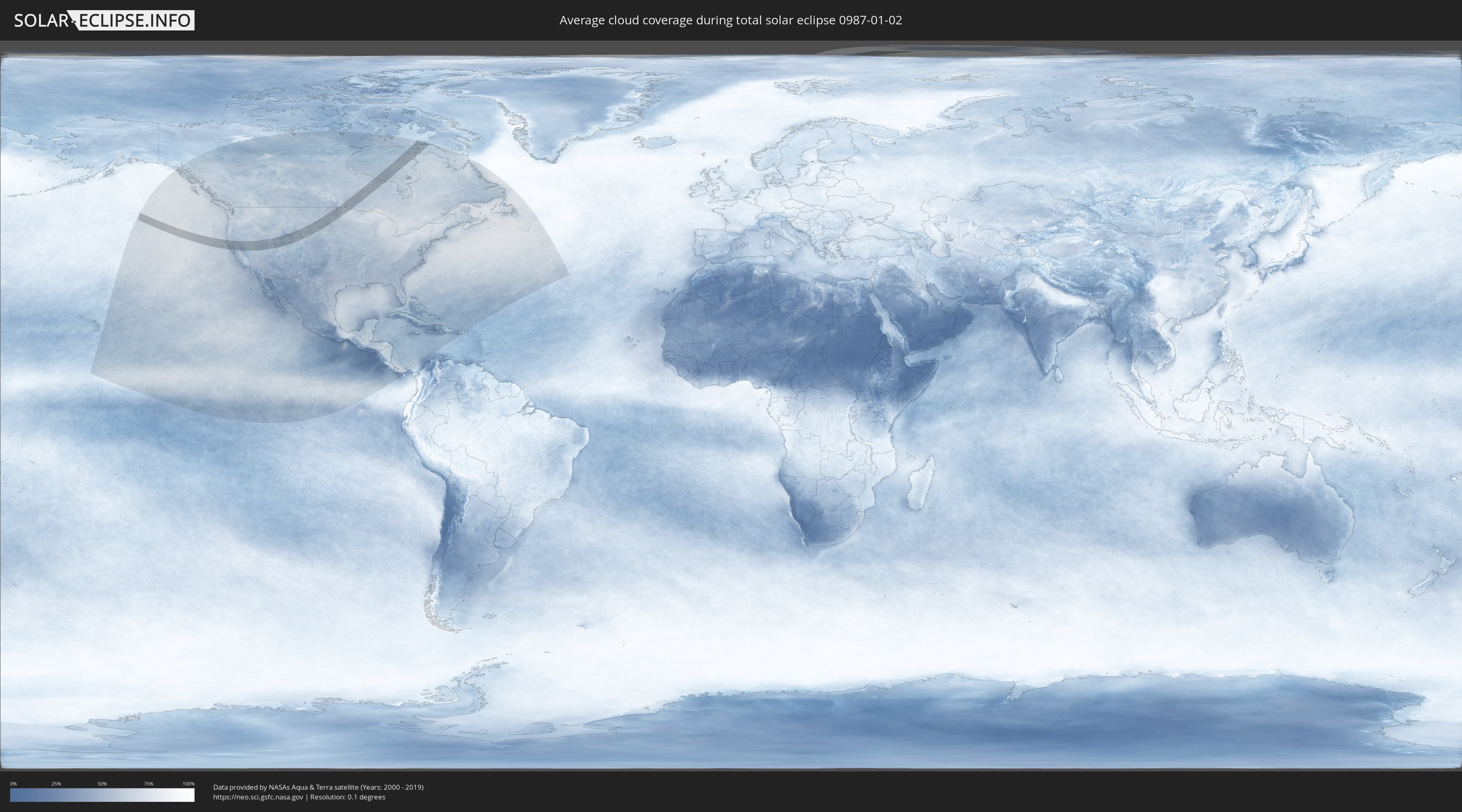
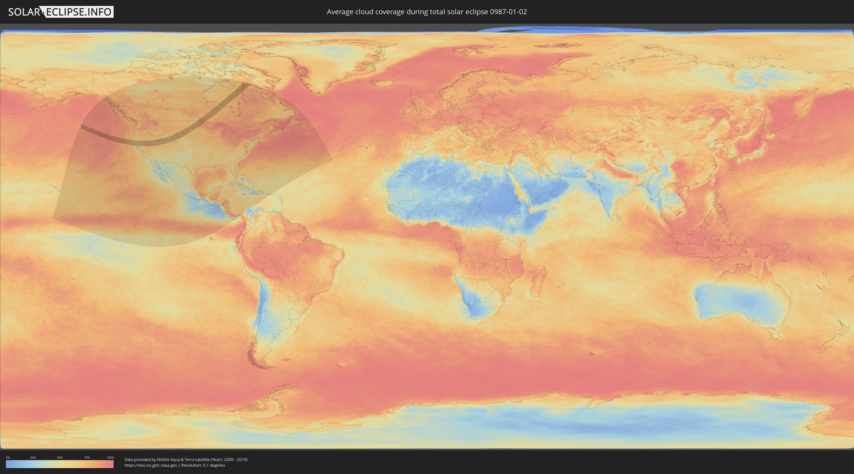
How will be the weather during the total solar eclipse on 01/02/0987?
Where is the best place to see the total solar eclipse of 01/02/0987?
The following maps show the average cloud coverage for the day of the total solar eclipse.
With the help of these maps, it is possible to find the place along the eclipse path, which has the best
chance of a cloudless sky.
Nevertheless, you should consider local circumstances and inform about the weather of your chosen
observation site.
The data is provided by NASAs satellites
AQUA and TERRA.
The cloud maps are averaged over a period of 19 years (2000 - 2019).
Detailed country maps
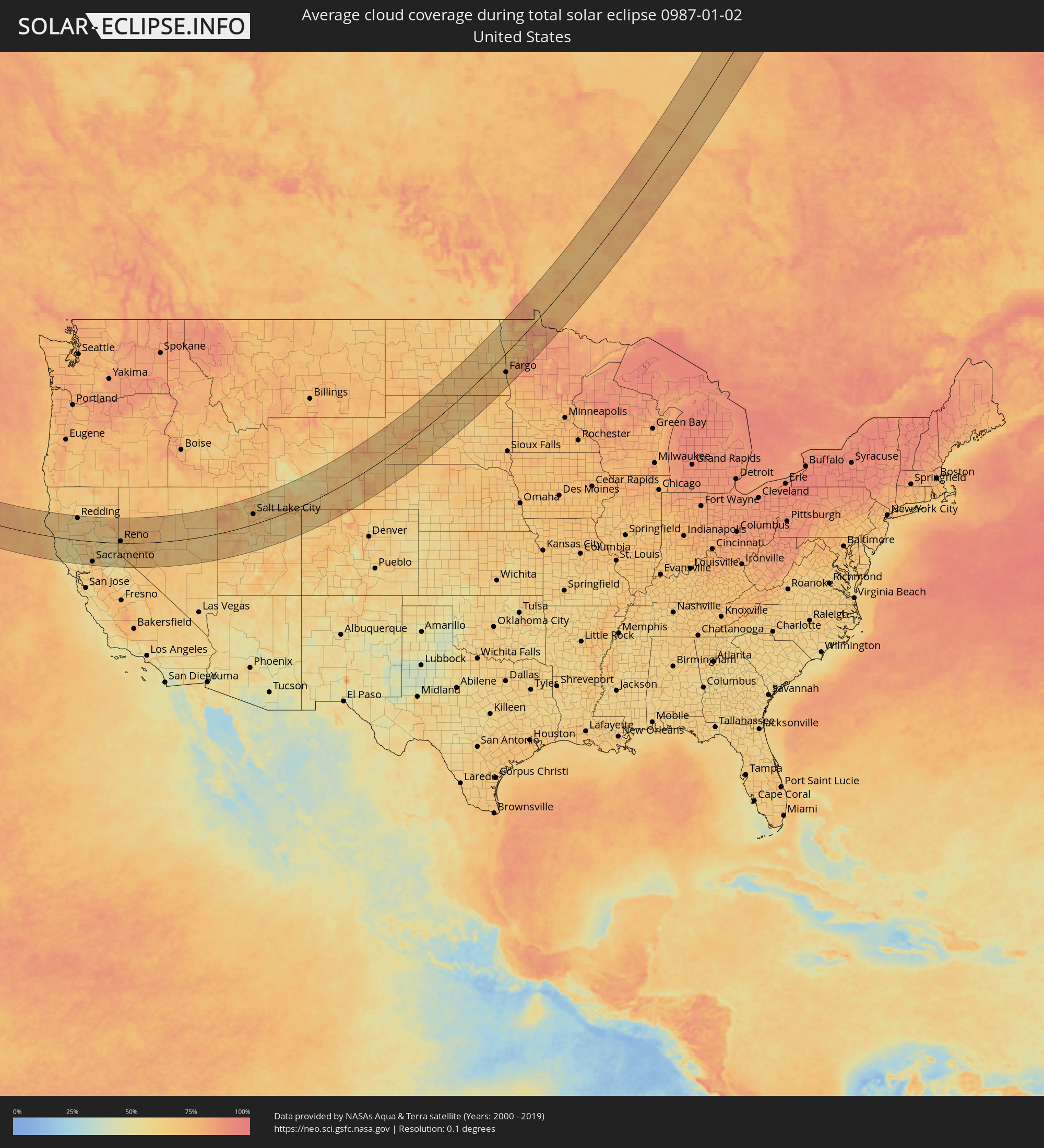 United States
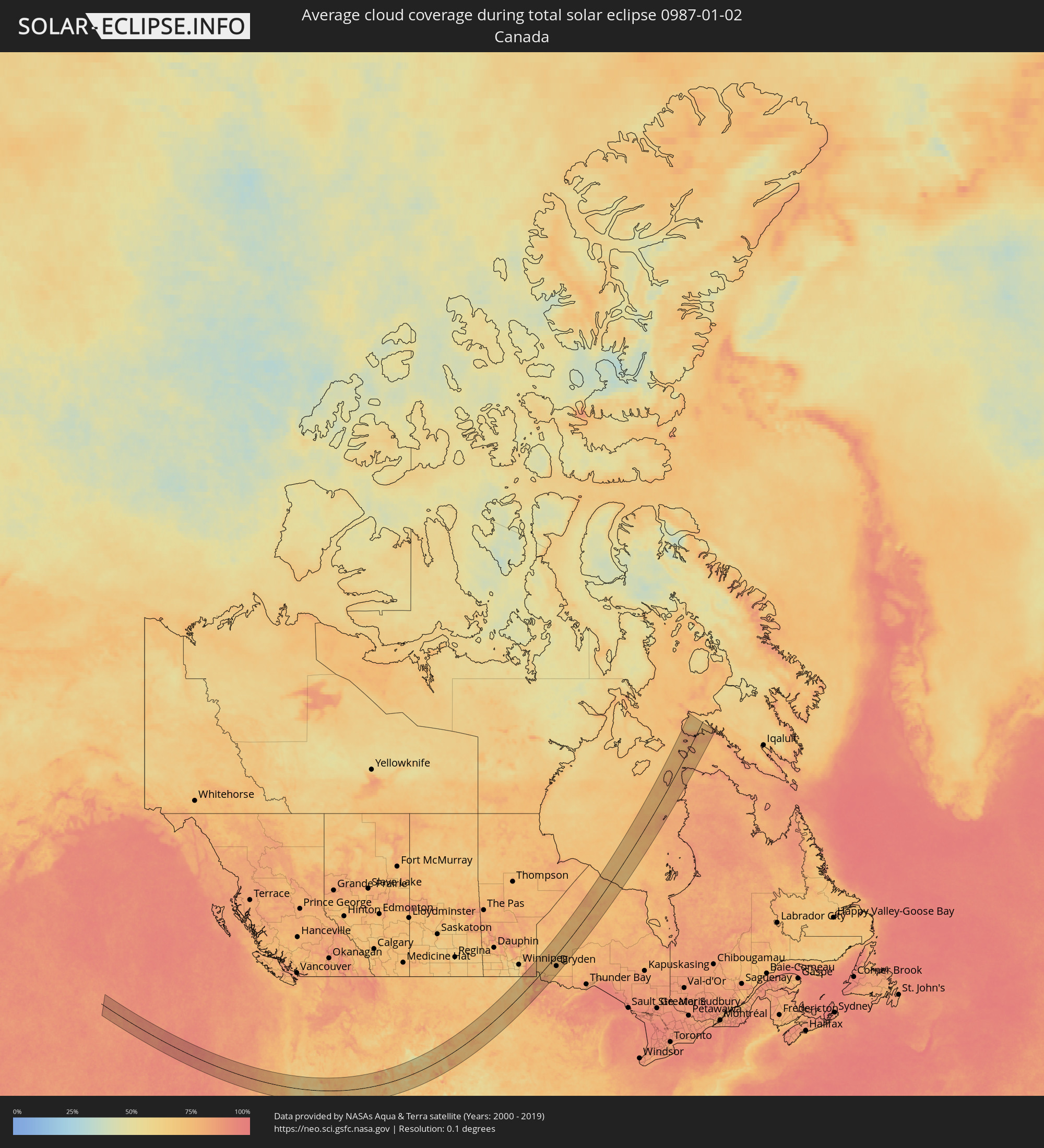 Canada
Cities inside the path of the eclipse
The following table shows all locations with a population of more than 5,000 inside the eclipse path. Cities which have more than 100,000 inhabitants are marked bold. A click at the locations opens a detailed map.
| City | Type | Eclipse duration | Local time of max. eclipse | Distance to central line | Ø Cloud coverage |
|
Eureka, California
|
total | - | 09:53:17 UTC-08:00 | 112 km | 68% |
|
Fortuna, California
|
total | - | 09:53:02 UTC-08:00 | 90 km | 64% |
|
Ukiah, California
|
total | - | 09:52:46 UTC-08:00 | 57 km | 57% |
|
Cloverdale, California
|
total | - | 09:52:39 UTC-08:00 | 93 km | 55% |
|
Healdsburg, California
|
total | - | 09:52:39 UTC-08:00 | 113 km | 56% |
|
Windsor, California
|
total | - | 09:52:40 UTC-08:00 | 119 km | 58% |
|
Clearlake, California
|
total | - | 09:53:29 UTC-08:00 | 72 km | 56% |
|
Redding, California
|
total | - | 09:55:50 UTC-08:00 | 111 km | 60% |
|
Shasta Lake, California
|
total | - | 09:55:59 UTC-08:00 | 121 km | 61% |
|
Anderson, California
|
total | - | 09:55:50 UTC-08:00 | 96 km | 63% |
|
Red Bluff, California
|
total | - | 09:55:36 UTC-08:00 | 67 km | 66% |
|
Corning, California
|
total | - | 09:55:24 UTC-08:00 | 40 km | 67% |
|
Chico, California
|
total | - | 09:55:43 UTC-08:00 | 21 km | 65% |
|
Woodland, California
|
total | - | 09:54:34 UTC-08:00 | 95 km | 64% |
|
Davis, California
|
total | - | 09:54:28 UTC-08:00 | 110 km | 64% |
|
Live Oak, California
|
total | - | 09:55:29 UTC-08:00 | 28 km | 67% |
|
Paradise, California
|
total | - | 09:56:07 UTC-08:00 | 26 km | 59% |
|
Yuba City, California
|
total | - | 09:55:23 UTC-08:00 | 43 km | 67% |
|
Marysville, California
|
total | - | 09:55:26 UTC-08:00 | 42 km | 67% |
|
Magalia, California
|
total | - | 09:56:15 UTC-08:00 | 32 km | 59% |
|
Oroville, California
|
total | - | 09:55:56 UTC-08:00 | 1 km | 65% |
|
Sacramento, California
|
total | - | 09:54:56 UTC-08:00 | 104 km | 66% |
|
Oroville East, California
|
total | - | 09:56:04 UTC-08:00 | 1 km | 62% |
|
Laguna, California
|
total | - | 09:54:52 UTC-08:00 | 121 km | 68% |
|
La Riviera, California
|
total | - | 09:55:09 UTC-08:00 | 105 km | 66% |
|
Rancho Cordova, California
|
total | - | 09:55:16 UTC-08:00 | 102 km | 68% |
|
Lincoln, California
|
total | - | 09:55:39 UTC-08:00 | 68 km | 68% |
|
Roseville, California
|
total | - | 09:55:29 UTC-08:00 | 84 km | 65% |
|
Gold River, California
|
total | - | 09:55:24 UTC-08:00 | 98 km | 67% |
|
El Dorado Hills, California
|
total | - | 09:55:46 UTC-08:00 | 90 km | 64% |
|
Auburn, California
|
total | - | 09:56:01 UTC-08:00 | 66 km | 60% |
|
Grass Valley, California
|
total | - | 09:56:26 UTC-08:00 | 31 km | 57% |
|
Diamond Springs, California
|
total | - | 09:56:14 UTC-08:00 | 88 km | 56% |
|
Placerville, California
|
total | - | 09:56:18 UTC-08:00 | 84 km | 56% |
|
Susanville, California
|
total | - | 09:58:32 UTC-08:00 | 105 km | 67% |
|
Truckee, California
|
total | - | 09:58:04 UTC-08:00 | 15 km | 56% |
|
South Lake Tahoe, California
|
total | - | 09:57:57 UTC-08:00 | 58 km | 57% |
|
Cold Springs, Nevada
|
total | - | 09:58:50 UTC-08:00 | 25 km | 71% |
|
Incline Village, Nevada
|
total | - | 09:58:20 UTC-08:00 | 23 km | 59% |
|
Reno, Nevada
|
total | - | 09:58:56 UTC-08:00 | 9 km | 76% |
|
Carson City, Nevada
|
total | - | 09:58:36 UTC-08:00 | 32 km | 71% |
|
Gardnerville Ranchos, Nevada
|
total | - | 09:58:20 UTC-08:00 | 63 km | 71% |
|
Spanish Springs, Nevada
|
total | - | 09:59:16 UTC-08:00 | 22 km | 76% |
|
Dayton, Nevada
|
total | - | 09:58:59 UTC-08:00 | 24 km | 70% |
|
Fernley, Nevada
|
total | - | 10:00:01 UTC-08:00 | 18 km | 75% |
|
Fallon, Nevada
|
total | - | 10:00:42 UTC-08:00 | 2 km | 78% |
|
Elko, Nevada
|
total | - | 10:07:36 UTC-08:00 | 132 km | 73% |
|
Spring Creek, Nevada
|
total | - | 10:07:49 UTC-08:00 | 118 km | 68% |
|
Grantsville, Utah
|
total | - | 11:13:30 UTC-07:00 | 46 km | 69% |
|
Tooele, Utah
|
total | - | 11:13:45 UTC-07:00 | 34 km | 67% |
|
Magna, Utah
|
total | - | 11:14:18 UTC-07:00 | 48 km | 71% |
|
West Point, Utah
|
total | - | 11:14:43 UTC-07:00 | 91 km | 71% |
|
West Haven, Utah
|
total | - | 11:14:51 UTC-07:00 | 99 km | 75% |
|
Oquirrh, Utah
|
total | - | 11:14:21 UTC-07:00 | 38 km | 74% |
|
Brigham City, Utah
|
total | - | 11:15:12 UTC-07:00 | 131 km | 75% |
|
Eagle Mountain, Utah
|
total | - | 11:14:07 UTC-07:00 | 4 km | 68% |
|
Riverdale, Utah
|
total | - | 11:14:55 UTC-07:00 | 95 km | 76% |
|
Pleasant View, Utah
|
total | - | 11:15:04 UTC-07:00 | 110 km | 76% |
|
Washington Terrace, Utah
|
total | - | 11:14:58 UTC-07:00 | 94 km | 76% |
|
Ogden, Utah
|
total | - | 11:15:01 UTC-07:00 | 99 km | 76% |
|
Layton, Utah
|
total | - | 11:14:52 UTC-07:00 | 82 km | 76% |
|
West Jordan, Utah
|
total | - | 11:14:31 UTC-07:00 | 34 km | 76% |
|
Bluffdale, Utah
|
total | - | 11:14:24 UTC-07:00 | 21 km | 73% |
|
Woods Cross, Utah
|
total | - | 11:14:51 UTC-07:00 | 60 km | 75% |
|
Salt Lake City, Utah
|
total | - | 11:14:45 UTC-07:00 | 48 km | 78% |
|
Centerville, Utah
|
total | - | 11:14:55 UTC-07:00 | 65 km | 75% |
|
Lehi, Utah
|
total | - | 11:14:29 UTC-07:00 | 8 km | 73% |
|
Little Cottonwood Creek Valley, Utah
|
total | - | 11:14:43 UTC-07:00 | 30 km | 74% |
|
Canyon Rim, Utah
|
total | - | 11:14:50 UTC-07:00 | 41 km | 76% |
|
Santaquin, Utah
|
total | - | 11:14:13 UTC-07:00 | 38 km | 65% |
|
Alpine, Utah
|
total | - | 11:14:41 UTC-07:00 | 13 km | 75% |
|
Cedar Hills, Utah
|
total | - | 11:14:41 UTC-07:00 | 8 km | 74% |
|
Payson, Utah
|
total | - | 11:14:23 UTC-07:00 | 32 km | 67% |
|
Lindon, Utah
|
total | - | 11:14:41 UTC-07:00 | 0 km | 74% |
|
Provo, Utah
|
total | - | 11:14:42 UTC-07:00 | 14 km | 68% |
|
Summit Park, Utah
|
total | - | 11:15:16 UTC-07:00 | 39 km | 66% |
|
Mapleton, Utah
|
total | - | 11:14:46 UTC-07:00 | 27 km | 68% |
|
Park City, Utah
|
total | - | 11:15:23 UTC-07:00 | 26 km | 70% |
|
Heber City, Utah
|
total | - | 11:15:25 UTC-07:00 | 9 km | 69% |
|
Evanston, Wyoming
|
total | - | 11:16:58 UTC-07:00 | 76 km | 60% |
|
Price, Utah
|
total | - | 11:15:46 UTC-07:00 | 103 km | 64% |
|
Vernal, Utah
|
total | - | 11:19:01 UTC-07:00 | 52 km | 71% |
|
Green River, Wyoming
|
total | - | 11:20:02 UTC-07:00 | 55 km | 68% |
|
Rock Springs, Wyoming
|
total | - | 11:20:35 UTC-07:00 | 52 km | 71% |
|
Craig, Colorado
|
total | - | 11:22:56 UTC-07:00 | 115 km | 74% |
|
Rawlins, Wyoming
|
total | - | 11:24:29 UTC-07:00 | 0 km | 70% |
|
Casper, Wyoming
|
total | - | 11:27:00 UTC-07:00 | 66 km | 73% |
|
Laramie, Wyoming
|
total | - | 11:27:18 UTC-07:00 | 113 km | 64% |
|
Spearfish, South Dakota
|
total | - | 11:32:32 UTC-07:00 | 104 km | 71% |
|
Rapid City, South Dakota
|
total | - | 11:33:27 UTC-07:00 | 38 km | 80% |
|
Rapid Valley, South Dakota
|
total | - | 11:33:35 UTC-07:00 | 32 km | 77% |
|
Box Elder, South Dakota
|
total | - | 11:33:45 UTC-07:00 | 33 km | 77% |
|
Pierre, South Dakota
|
total | - | 12:38:47 UTC-06:00 | 80 km | 69% |
|
Jamestown, North Dakota
|
total | - | 12:42:33 UTC-06:00 | 45 km | 73% |
|
Aberdeen, South Dakota
|
total | - | 12:42:28 UTC-06:00 | 84 km | 75% |
|
Grand Forks, North Dakota
|
total | - | 12:45:33 UTC-06:00 | 34 km | 69% |
|
East Grand Forks, Minnesota
|
total | - | 12:45:34 UTC-06:00 | 34 km | 69% |
|
Fargo, North Dakota
|
total | - | 12:45:43 UTC-06:00 | 60 km | 76% |
|
Crookston, Minnesota
|
total | - | 12:46:12 UTC-06:00 | 0 km | 71% |
|
Thief River Falls, Minnesota
|
total | - | 12:46:57 UTC-06:00 | 3 km | 69% |
|
Dryden, Ontario
|
total | - | 12:52:21 UTC-06:00 | 60 km | 79% |