Total solar eclipse of 02/15/1059
| Day of week: | Tuesday |
| Maximum duration of eclipse: | 03m26s |
| Maximum width of eclipse path: | 287 km |
| Saros cycle: | 115 |
| Coverage: | 100% |
| Magnitude: | 1.0465 |
| Gamma: | 0.8492 |
Wo kann man die Sonnenfinsternis vom 02/15/1059 sehen?
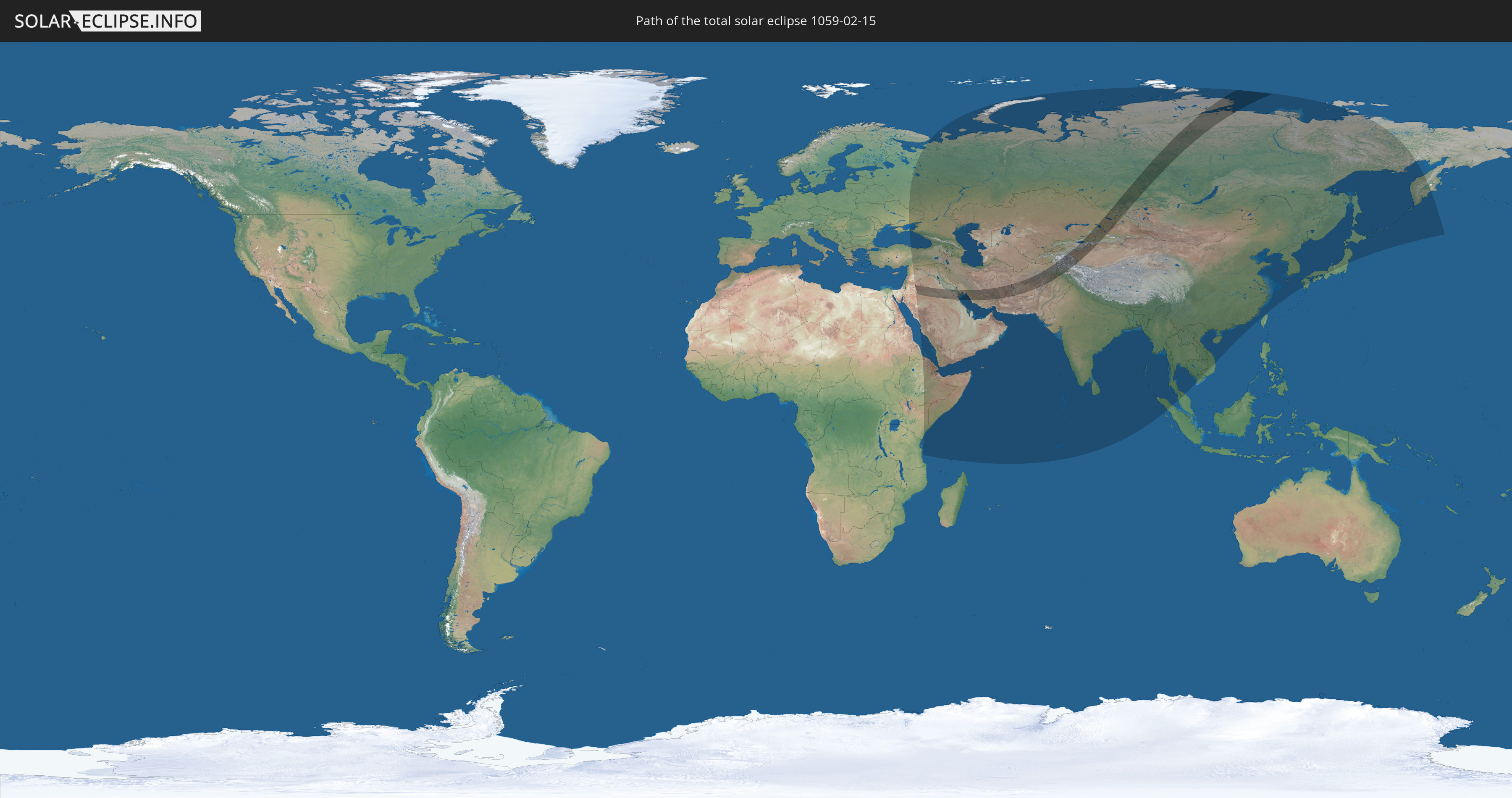
Die Sonnenfinsternis am 02/15/1059 kann man in 53 Ländern als partielle Sonnenfinsternis beobachten.
Der Finsternispfad verläuft durch 12 Länder. Nur in diesen Ländern ist sie als total Sonnenfinsternis zu sehen.
In den folgenden Ländern ist die Sonnenfinsternis total zu sehen
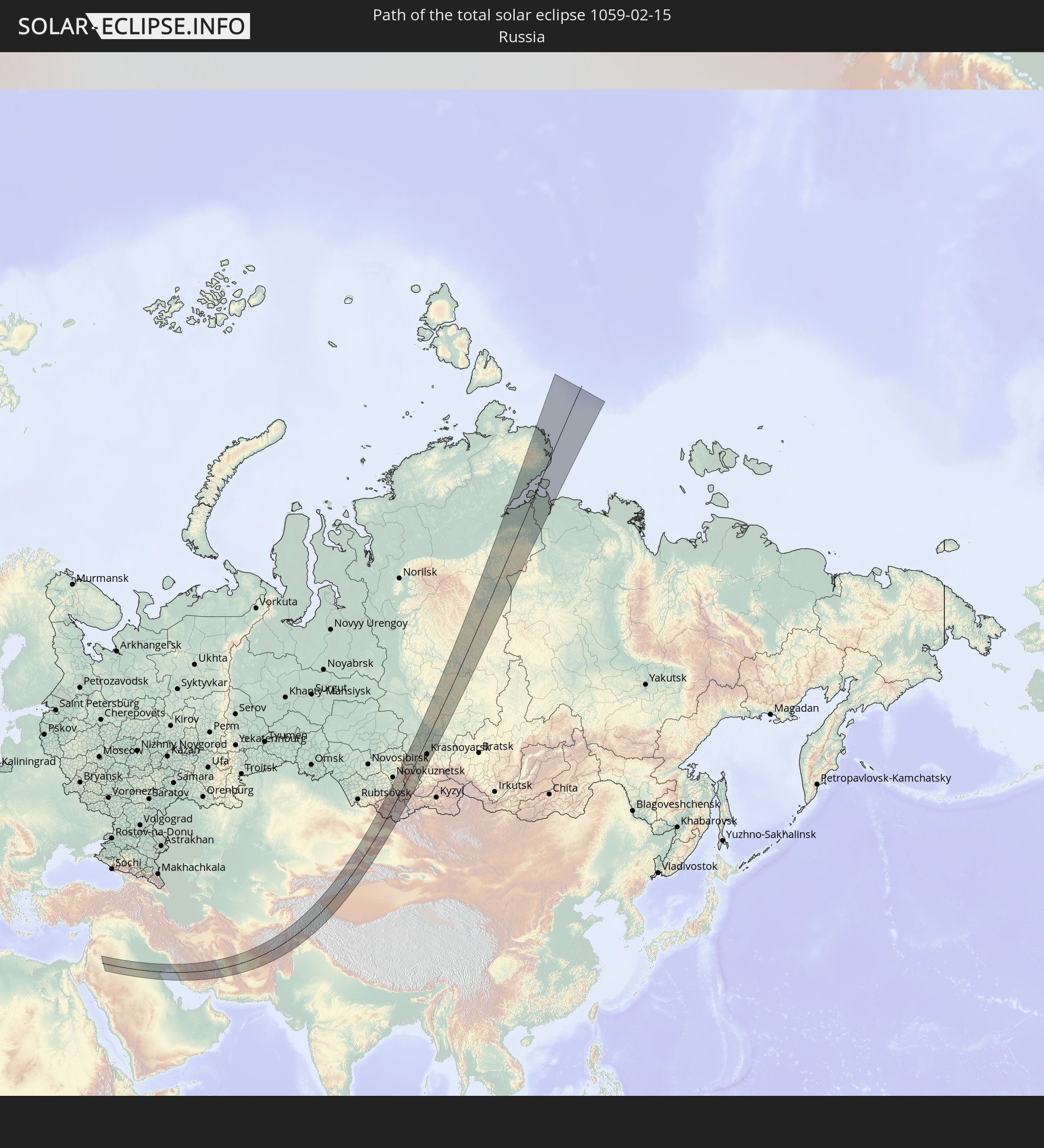 Russia
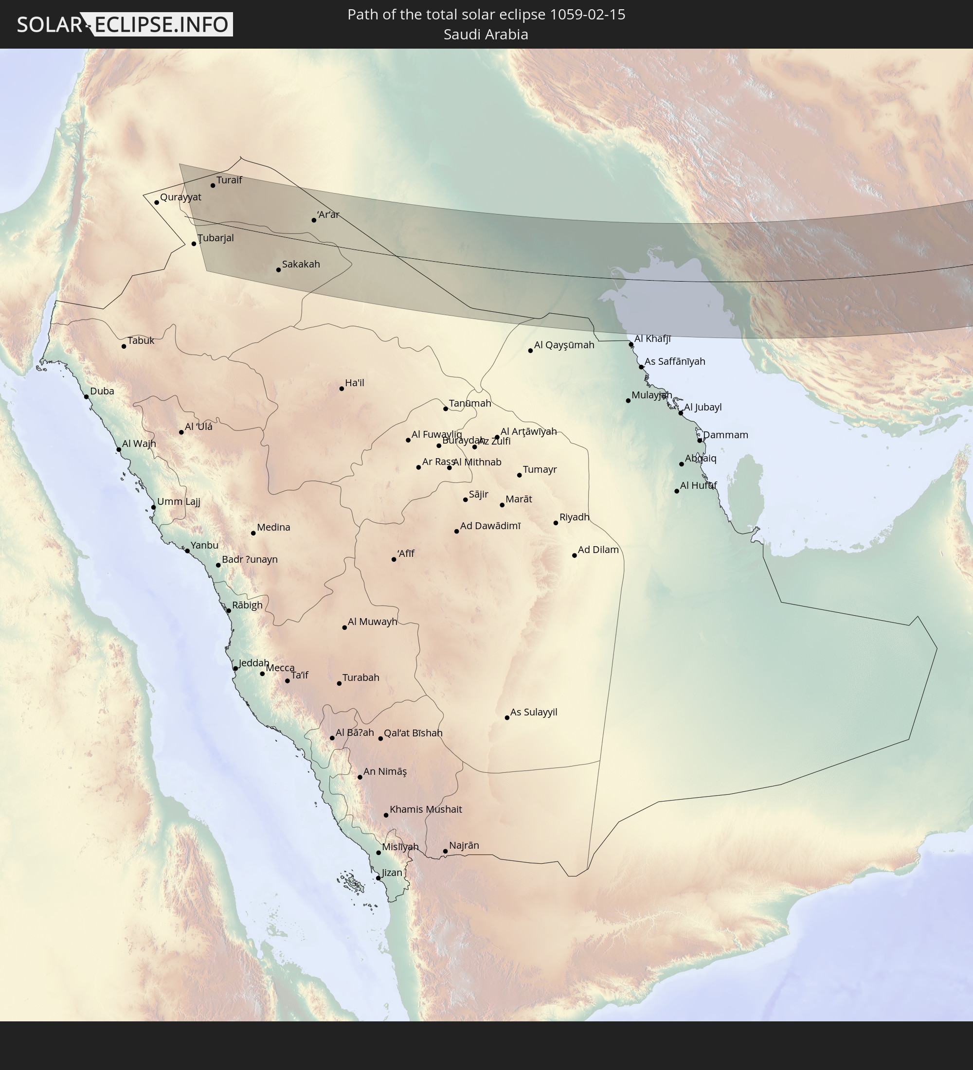 Saudi Arabia
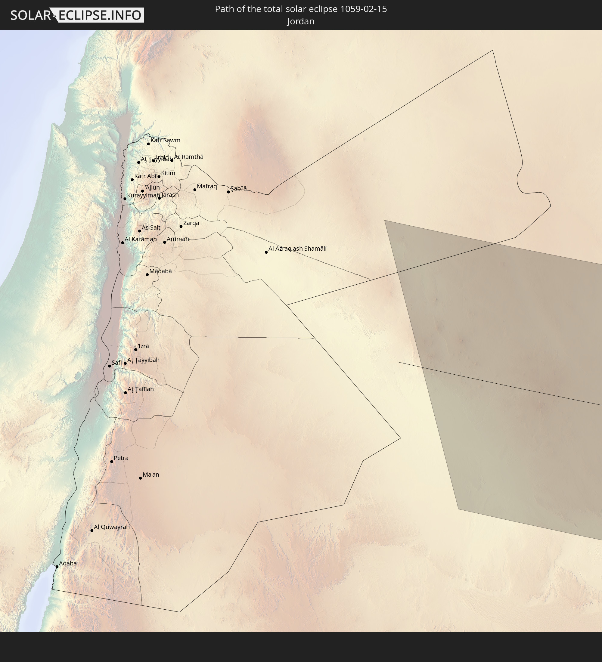 Jordan
 Iraq
Iraq
 Iran
Iran
 Kazakhstan
 Kuwait
 Afghanistan
 Pakistan
 Tajikistan
 Kyrgyzstan
 China
China
In den folgenden Ländern ist die Sonnenfinsternis partiell zu sehen
 Russia
 Ukraine
 Turkey
 Tanzania
 Ethiopia
 Kenya
Kenya
 Saudi Arabia
 Jordan
 Syria
Syria
 Eritrea
 Iraq
Iraq
 Georgia
 Somalia
 Djibouti
 Yemen
Yemen
 Armenia
 Iran
Iran
 Azerbaijan
 Seychelles
 Kazakhstan
 Kuwait
 Bahrain
 Qatar
Qatar
 United Arab Emirates
 Oman
Oman
 Turkmenistan
 Uzbekistan
 Afghanistan
 Pakistan
 Tajikistan
 India
India
 Kyrgyzstan
 British Indian Ocean Territory
 Maldives
 China
China
 Sri Lanka
 Nepal
Nepal
 Mongolia
 Bangladesh
 Bhutan
 Myanmar
 Indonesia
 Thailand
 Malaysia
 Laos
Laos
 Vietnam
 Cambodia
 Macau
Macau
 Hong Kong
 Taiwan
 Japan
Japan
 North Korea
 South Korea
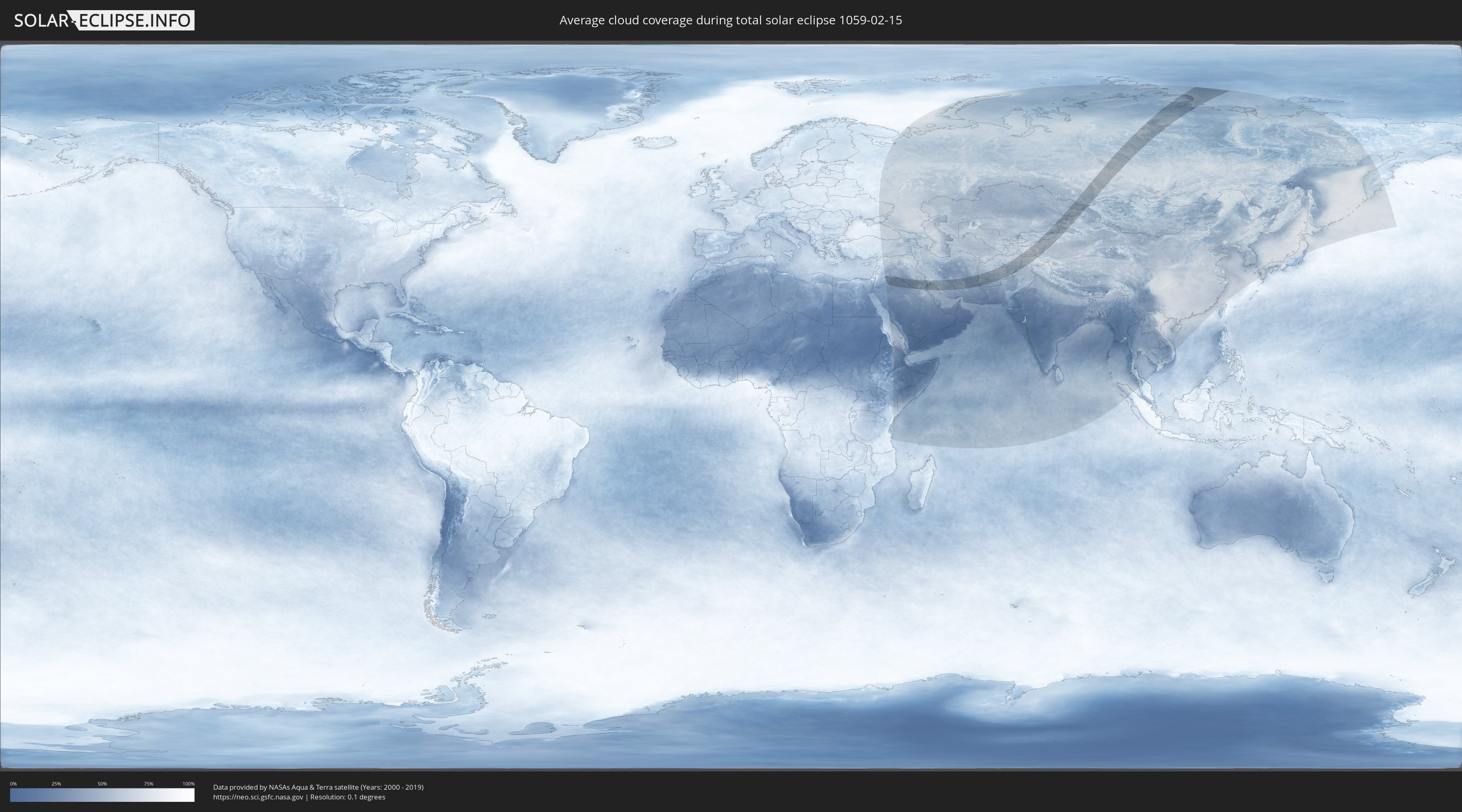
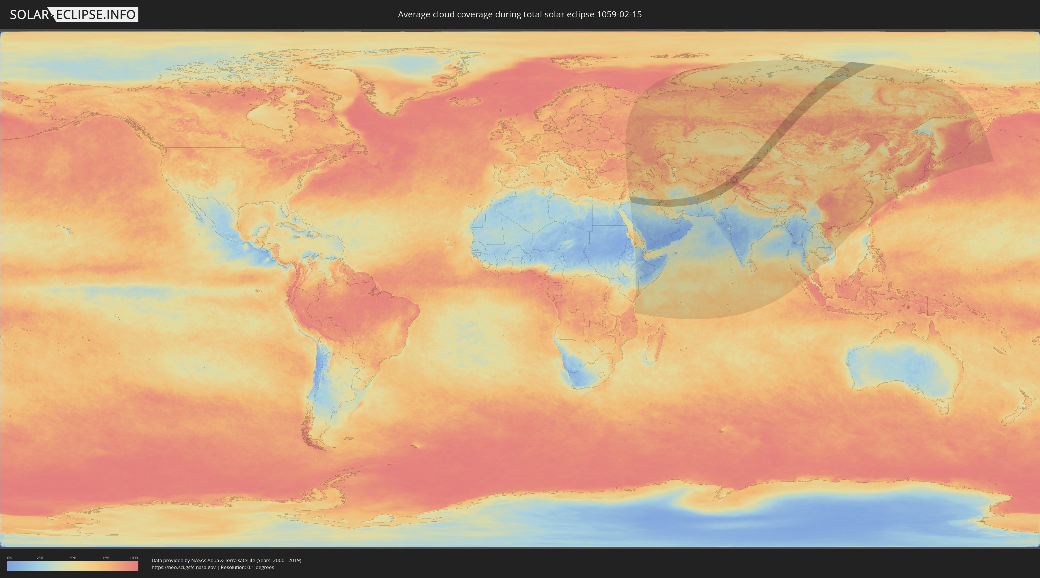
How will be the weather during the total solar eclipse on 02/15/1059?
Where is the best place to see the total solar eclipse of 02/15/1059?
The following maps show the average cloud coverage for the day of the total solar eclipse.
With the help of these maps, it is possible to find the place along the eclipse path, which has the best
chance of a cloudless sky.
Nevertheless, you should consider local circumstances and inform about the weather of your chosen
observation site.
The data is provided by NASAs satellites
AQUA and TERRA.
The cloud maps are averaged over a period of 19 years (2000 - 2019).
Detailed country maps
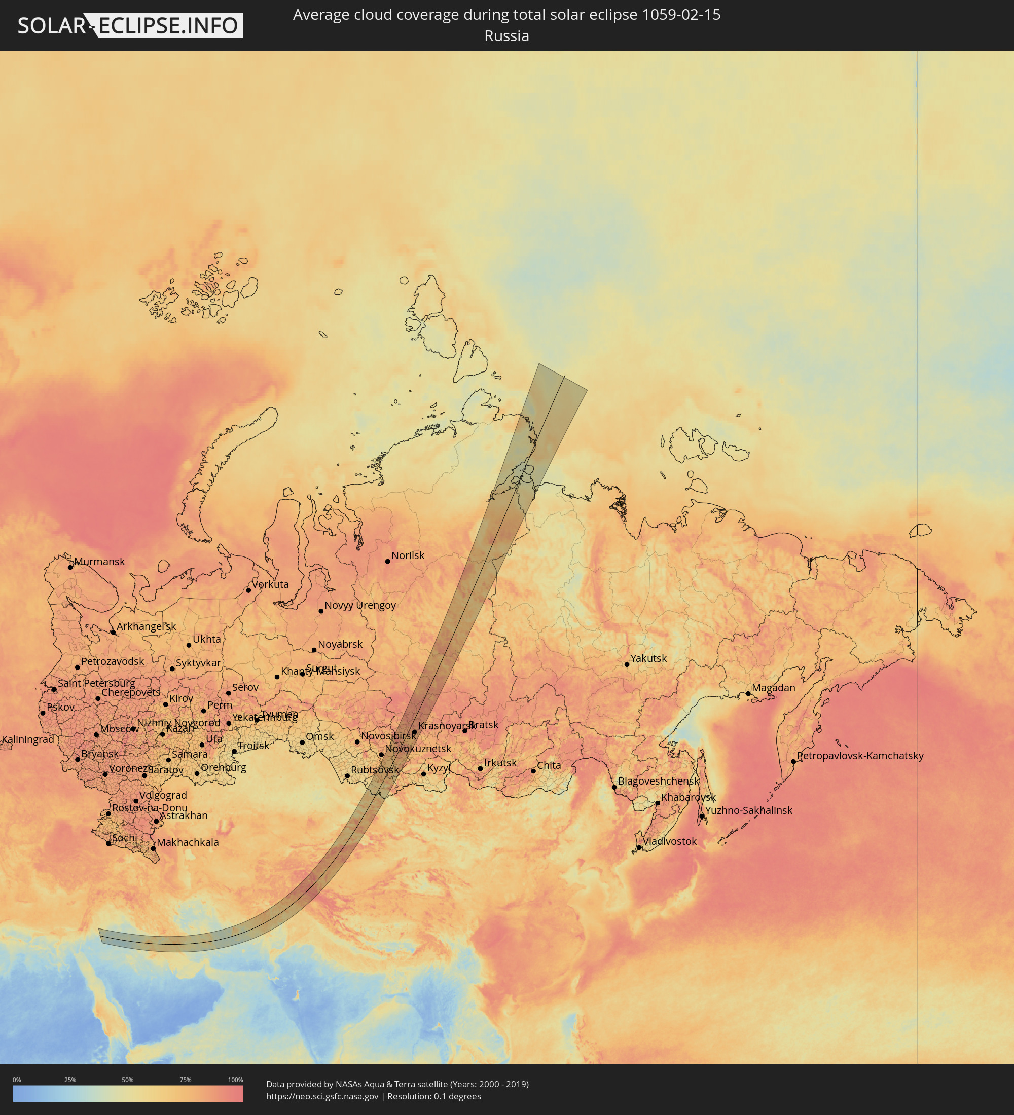 Russia
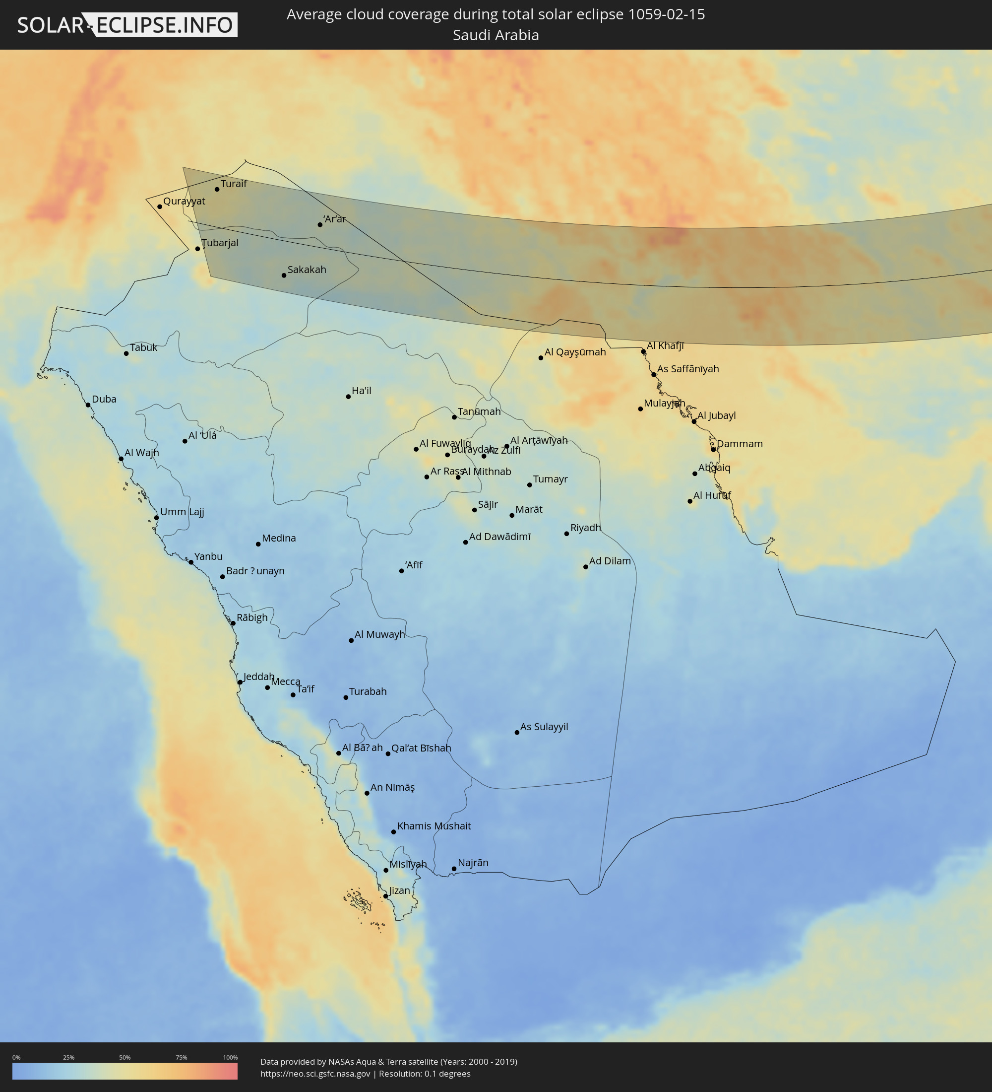 Saudi Arabia
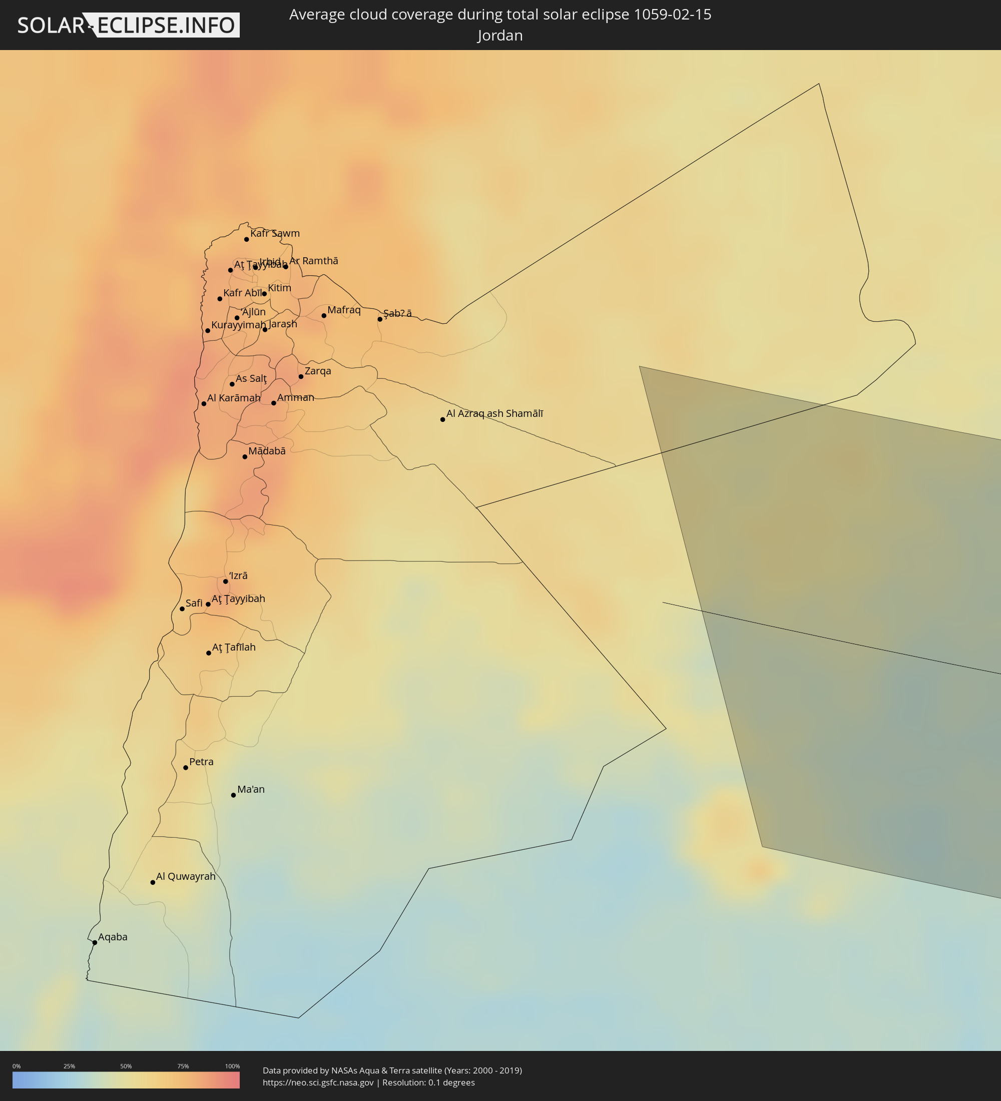 Jordan
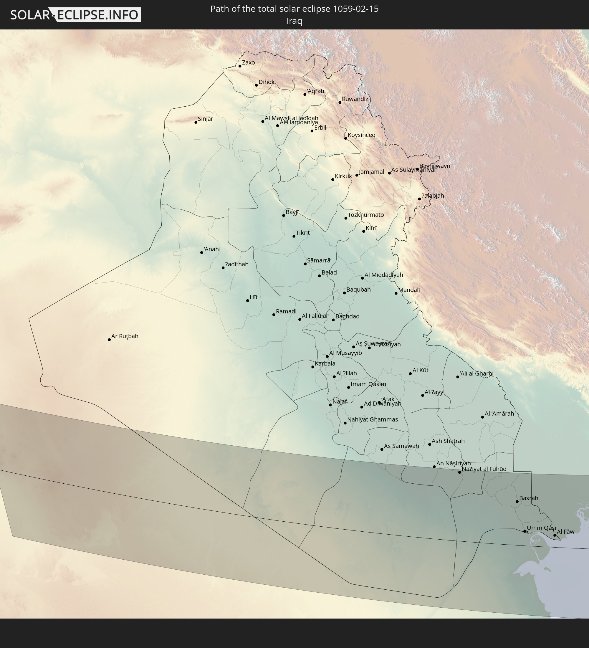
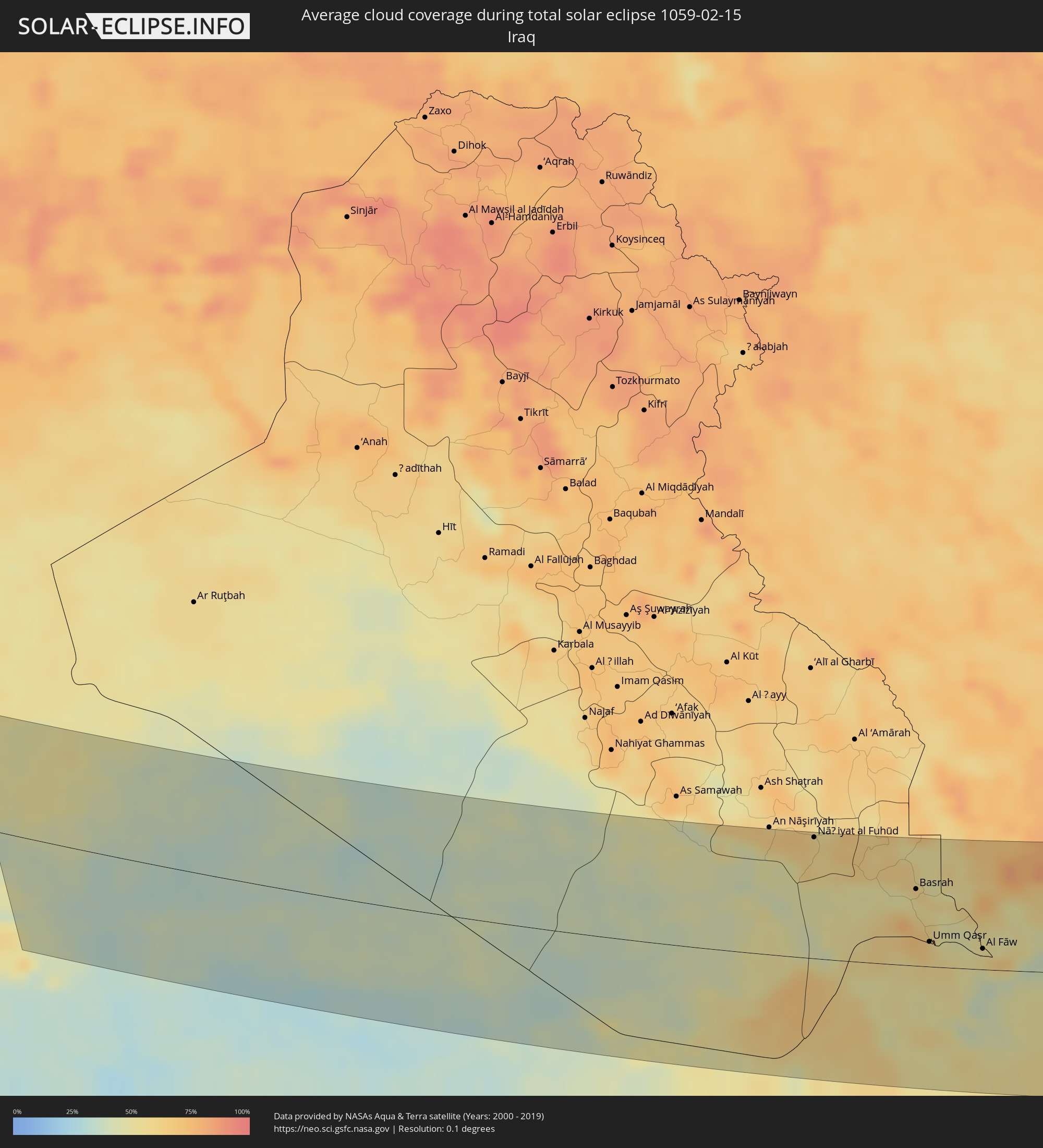 Iraq
Iraq
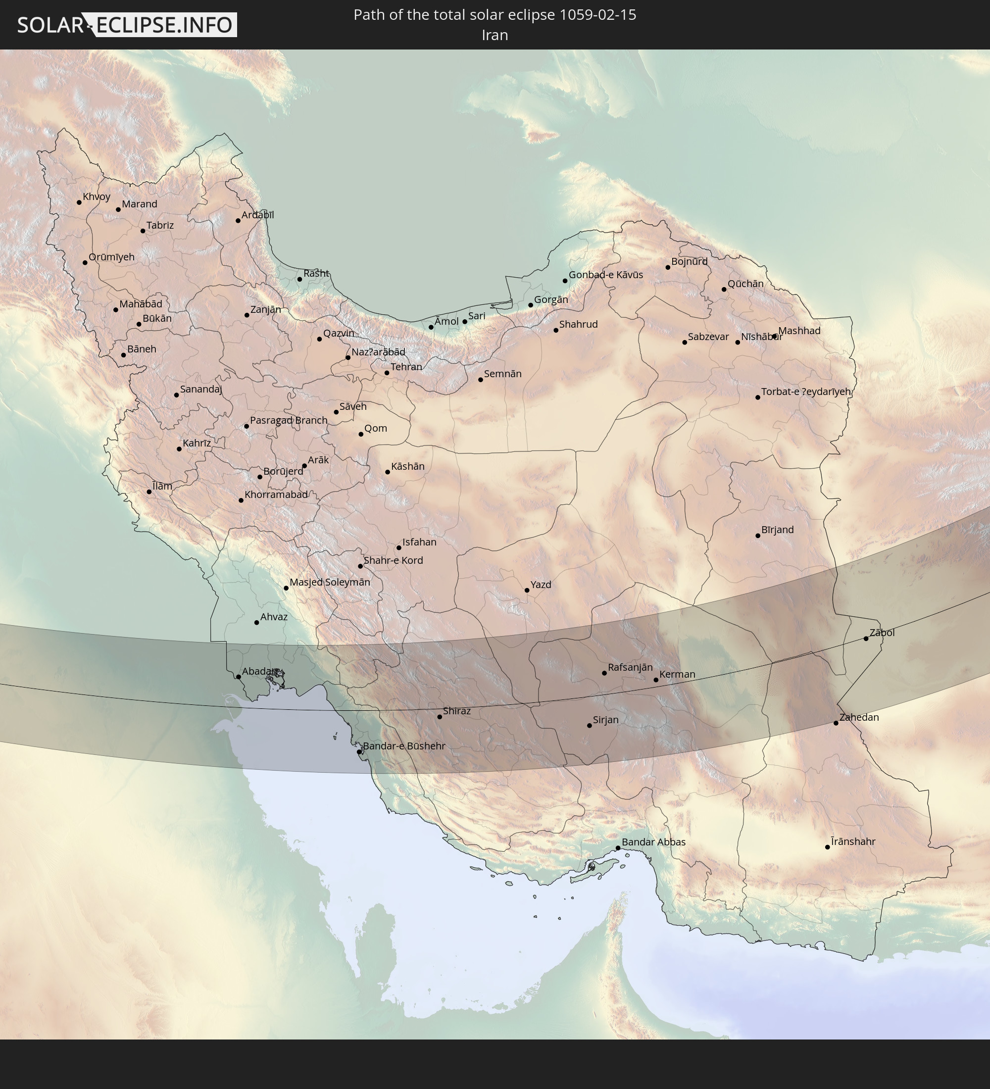
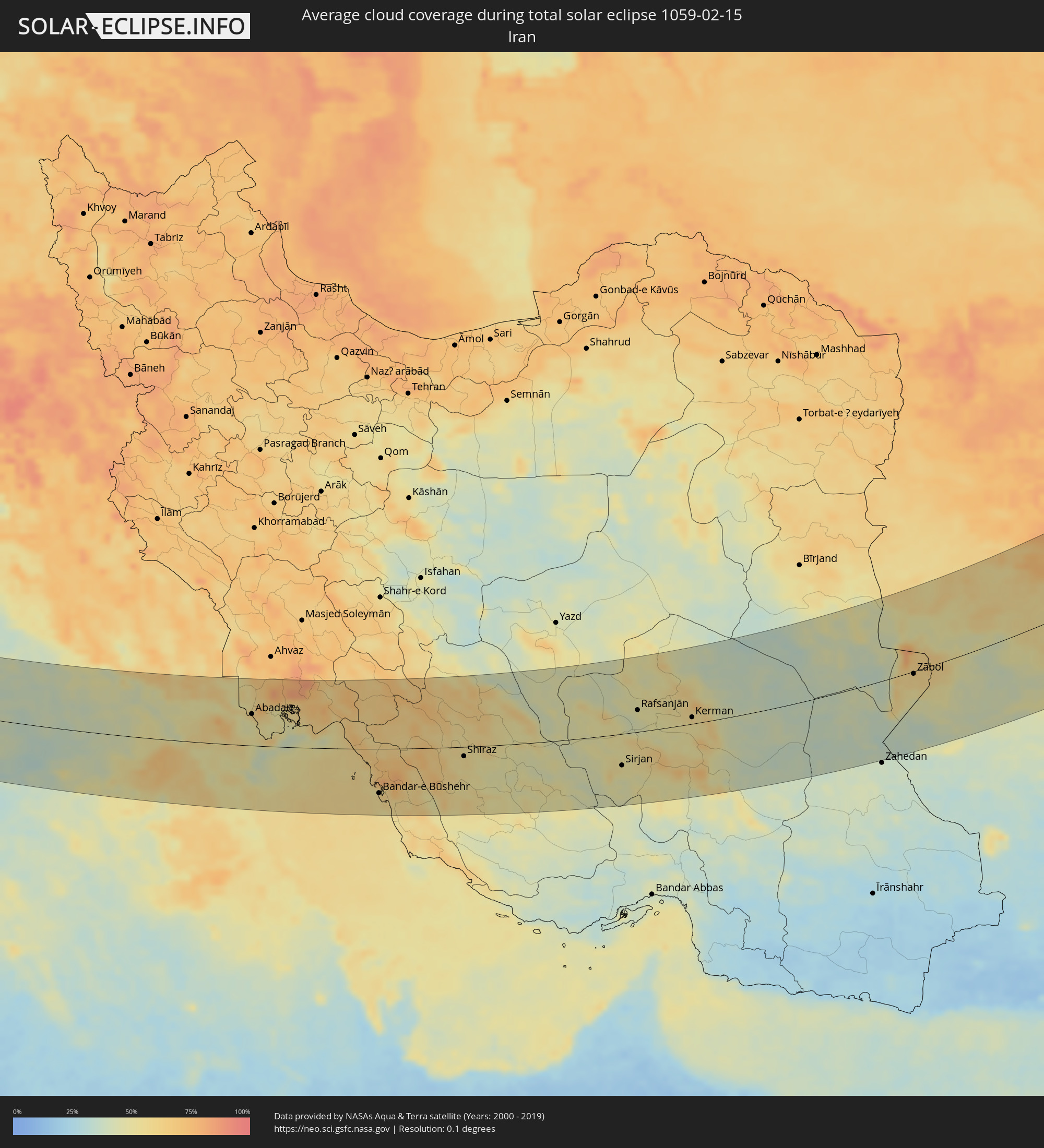 Iran
Iran
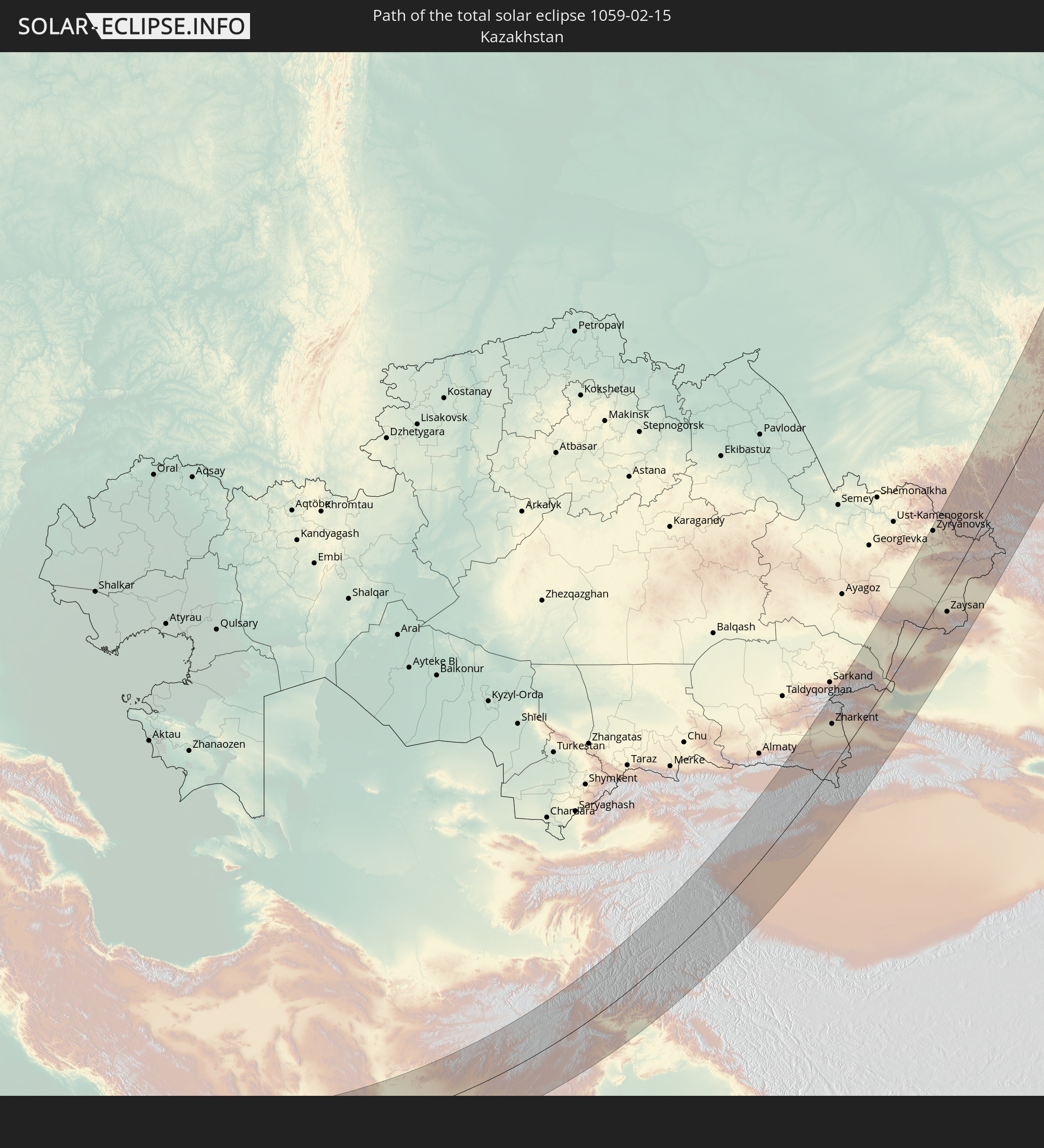
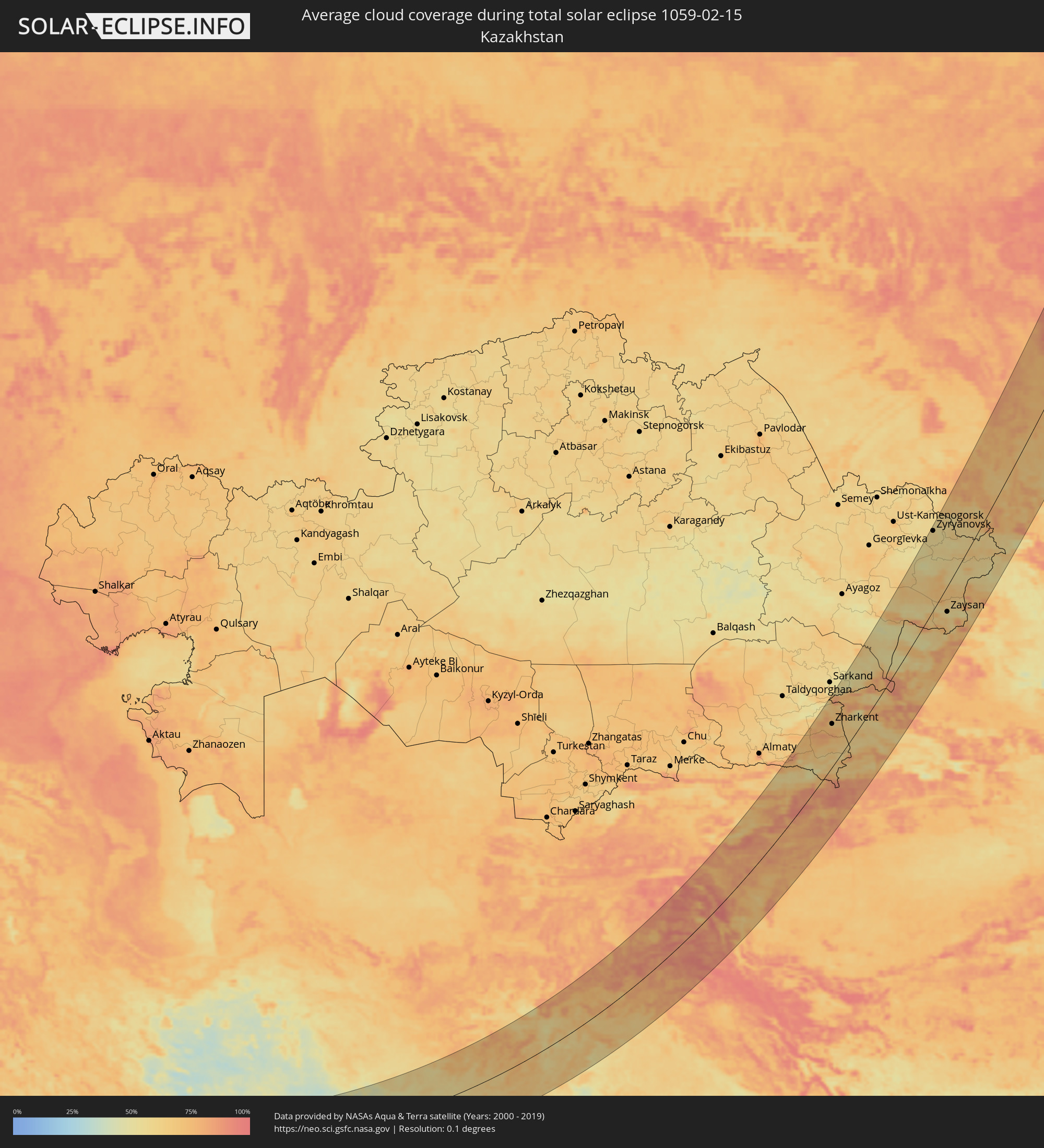 Kazakhstan
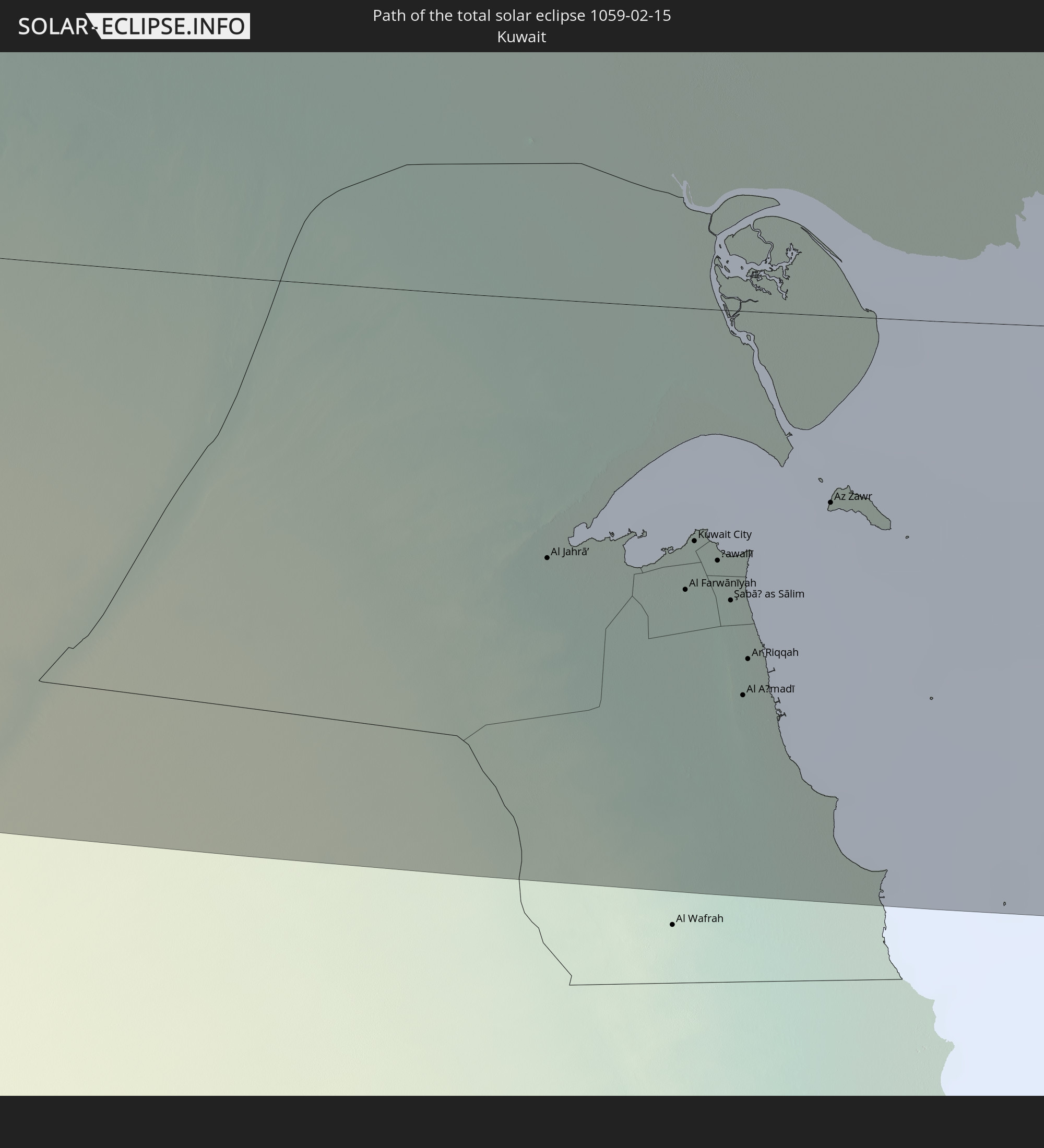
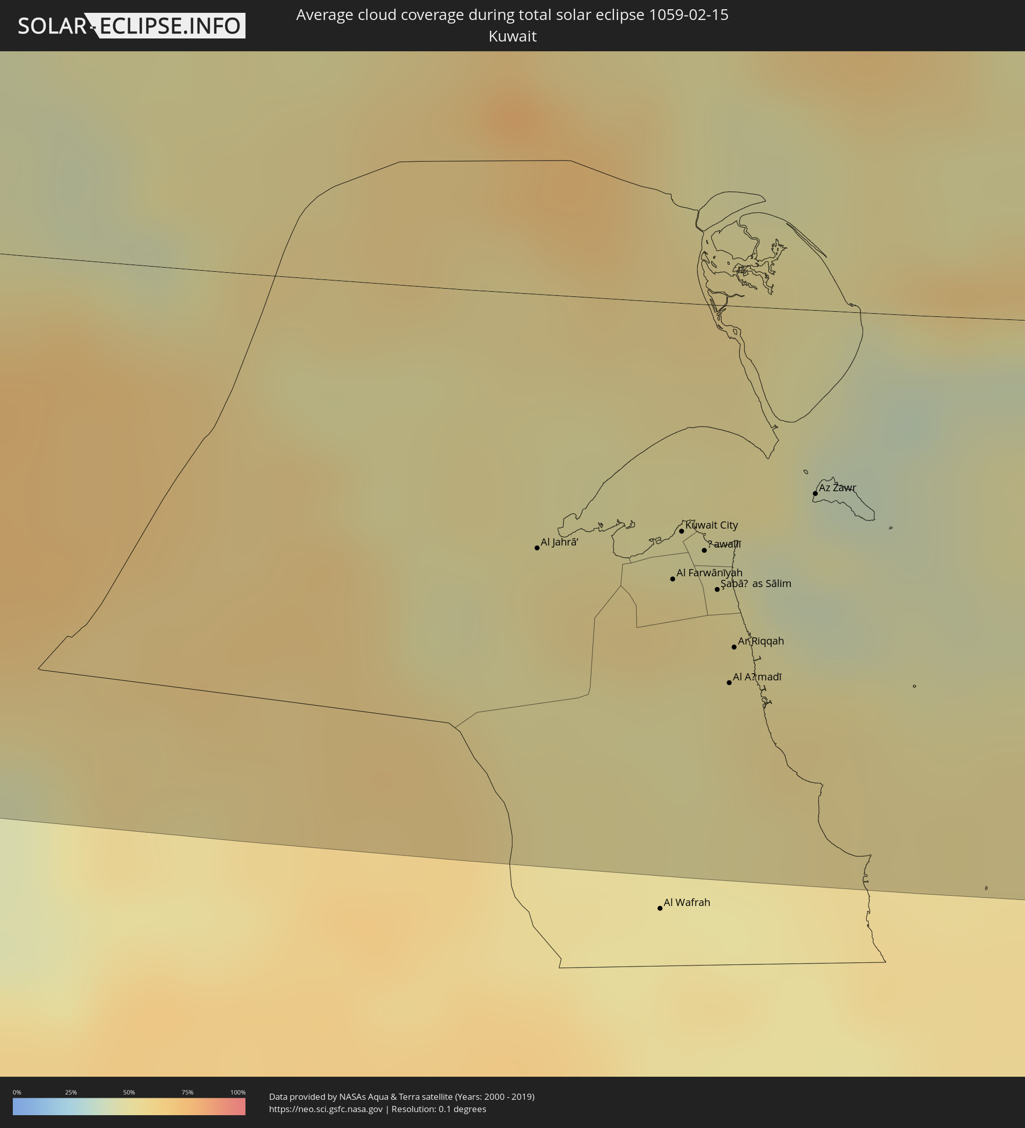 Kuwait
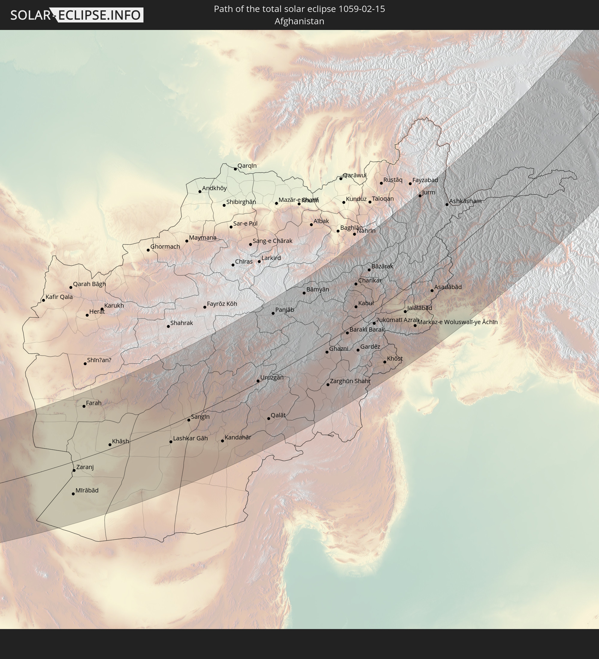
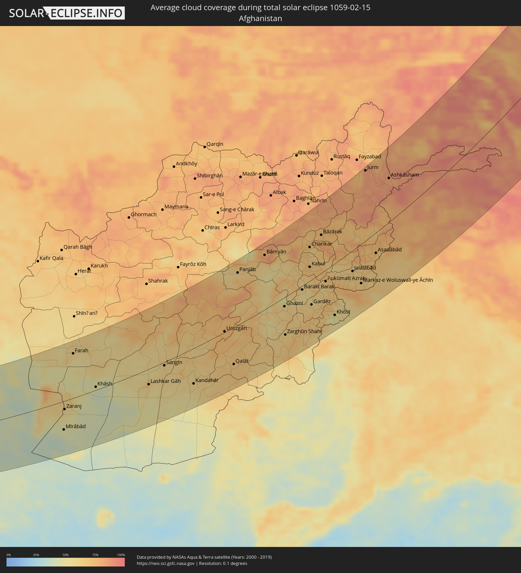 Afghanistan
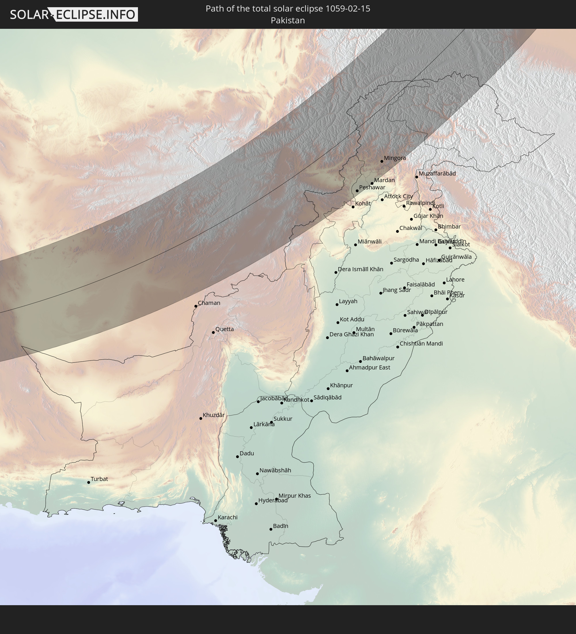
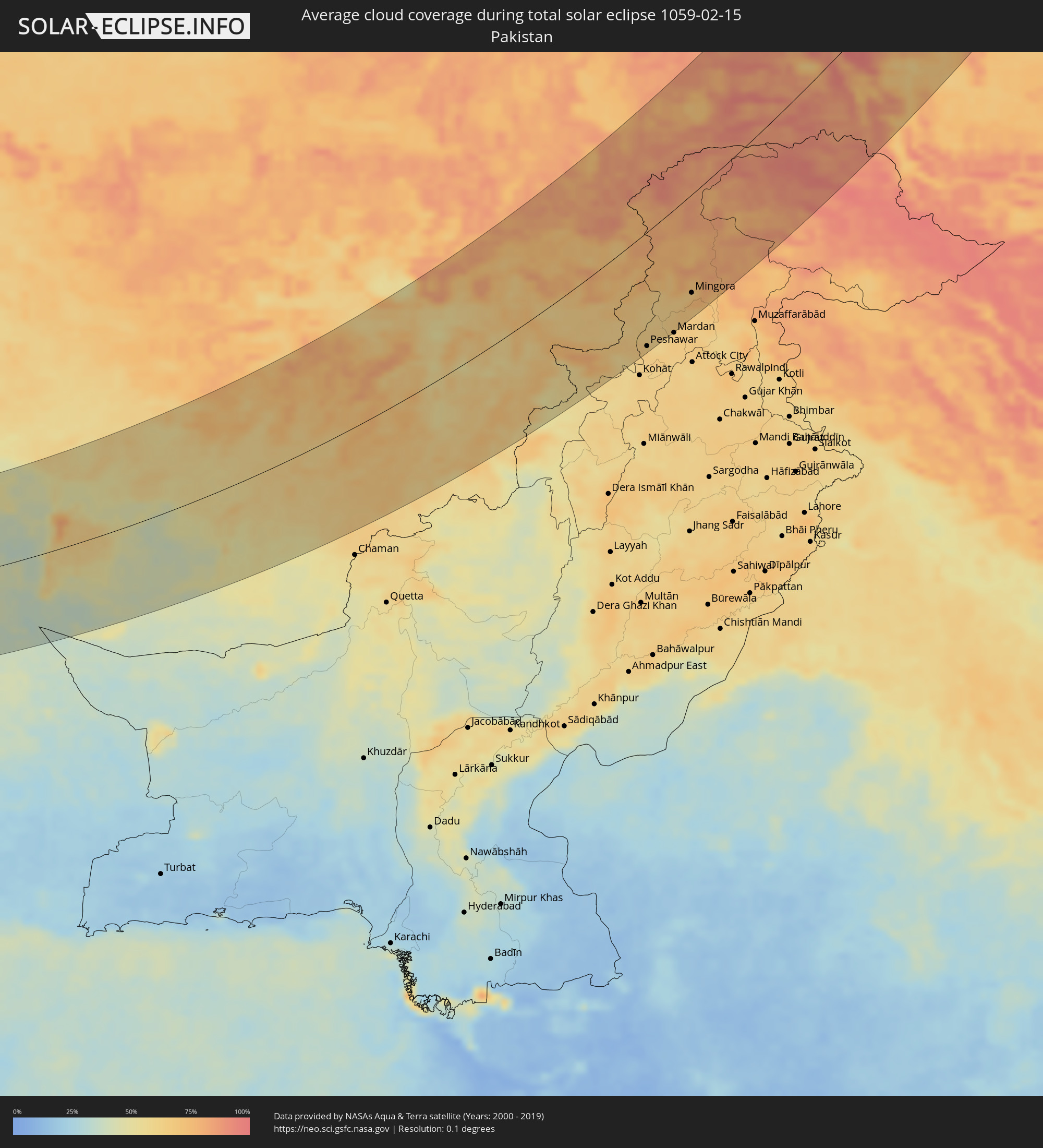 Pakistan
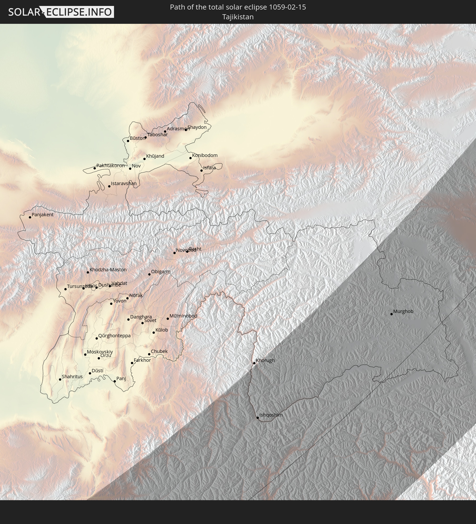
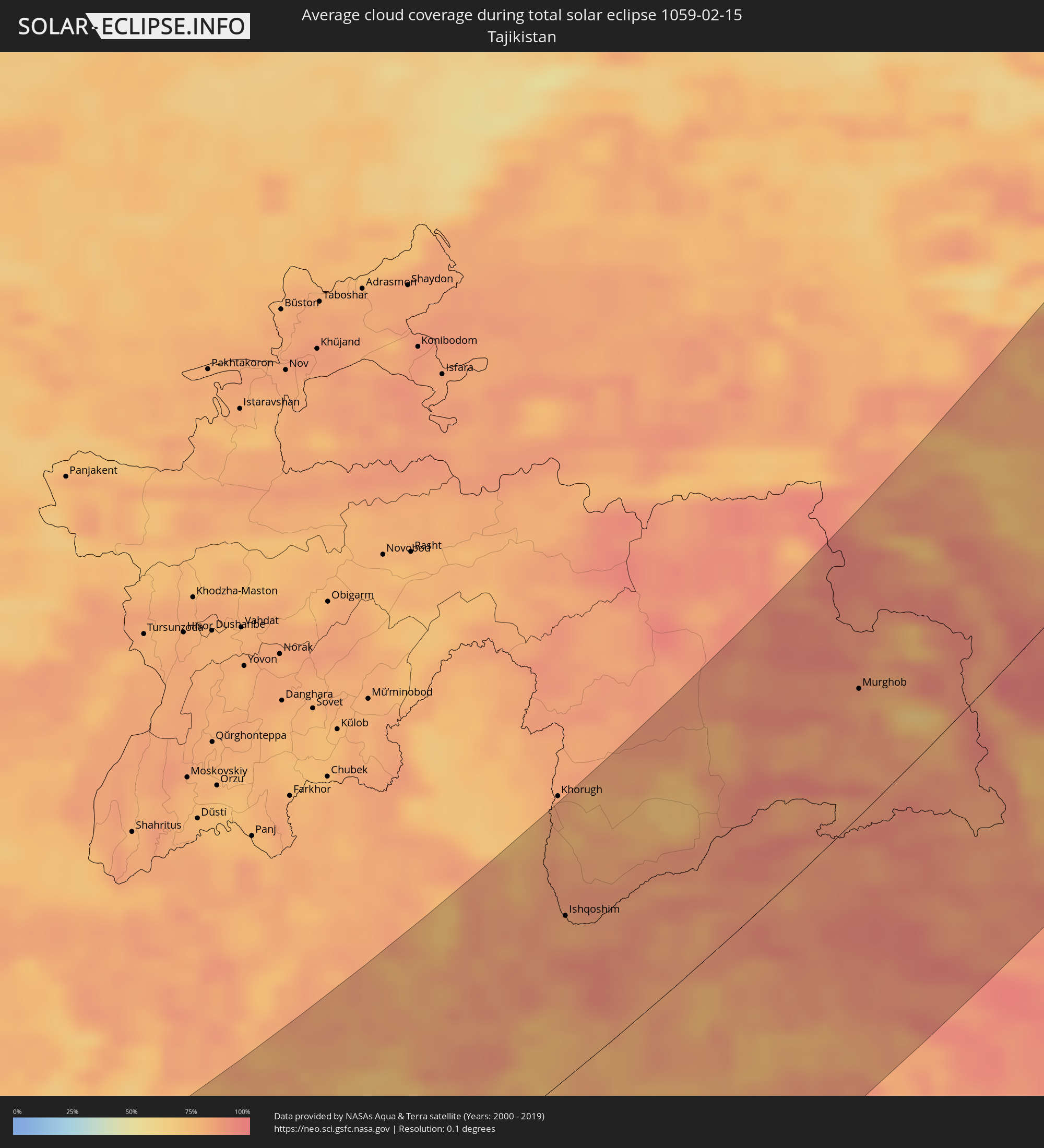 Tajikistan
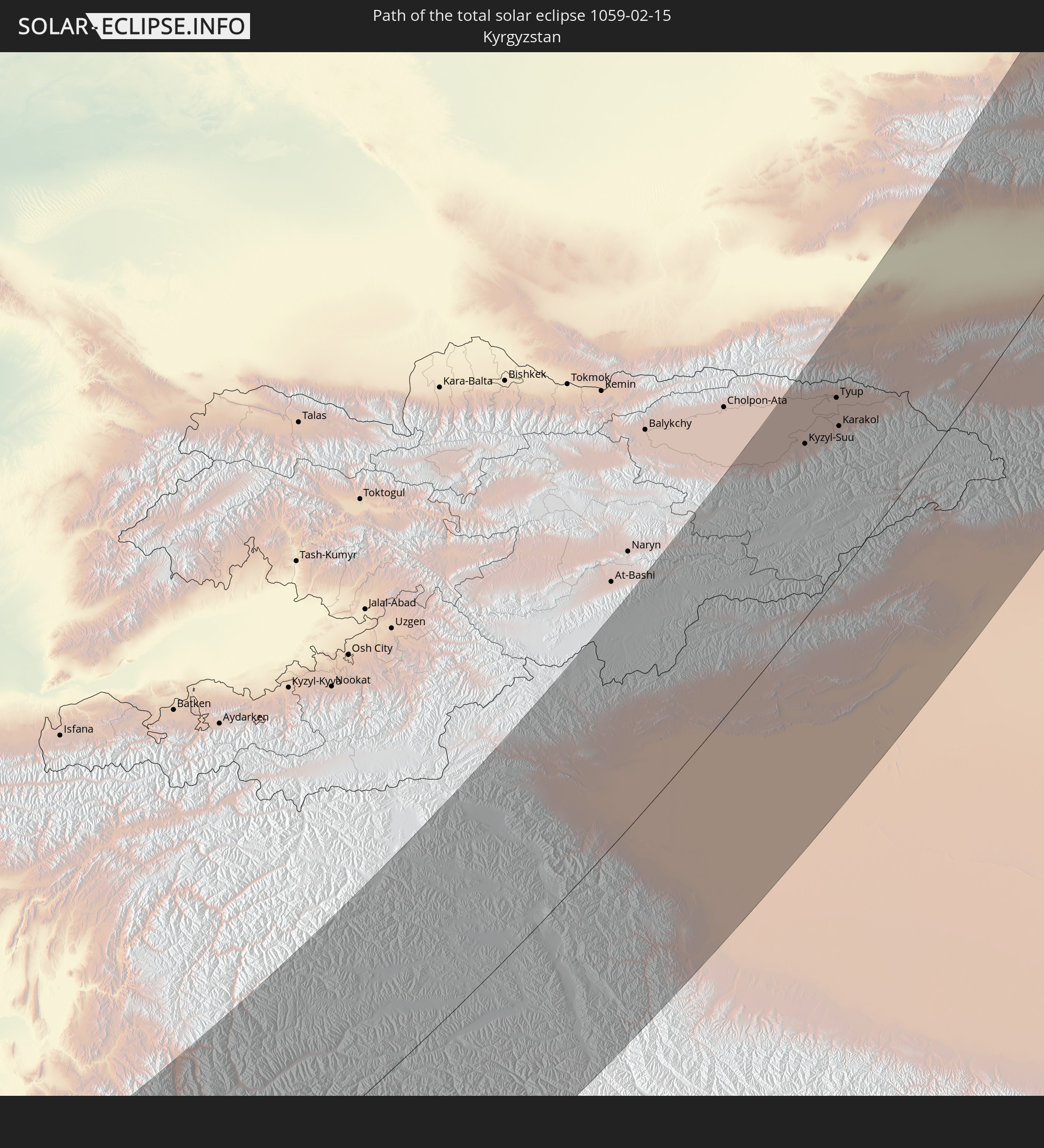
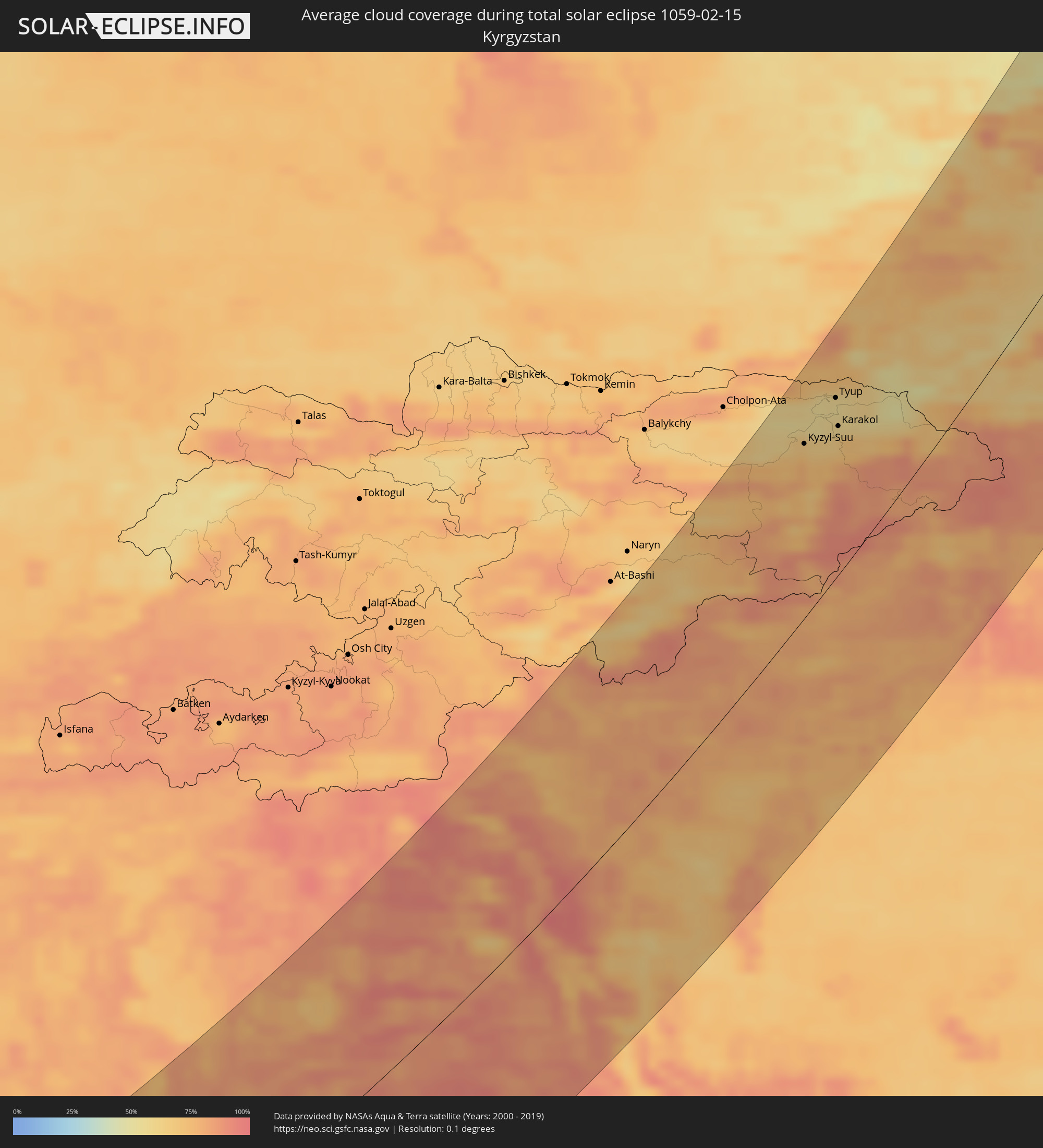 Kyrgyzstan
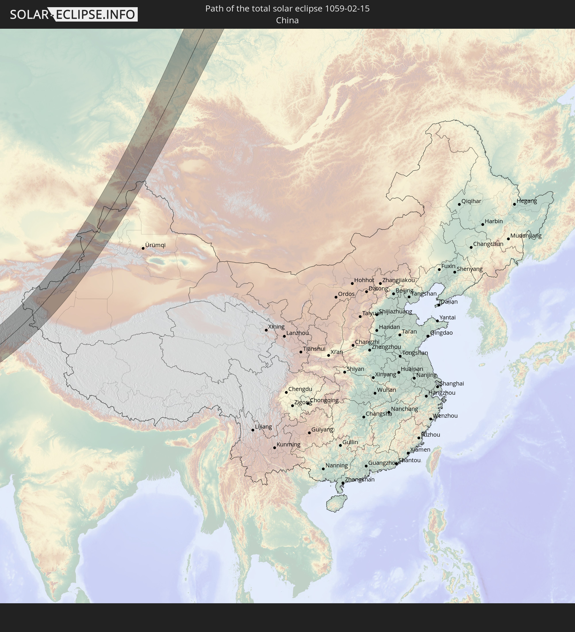
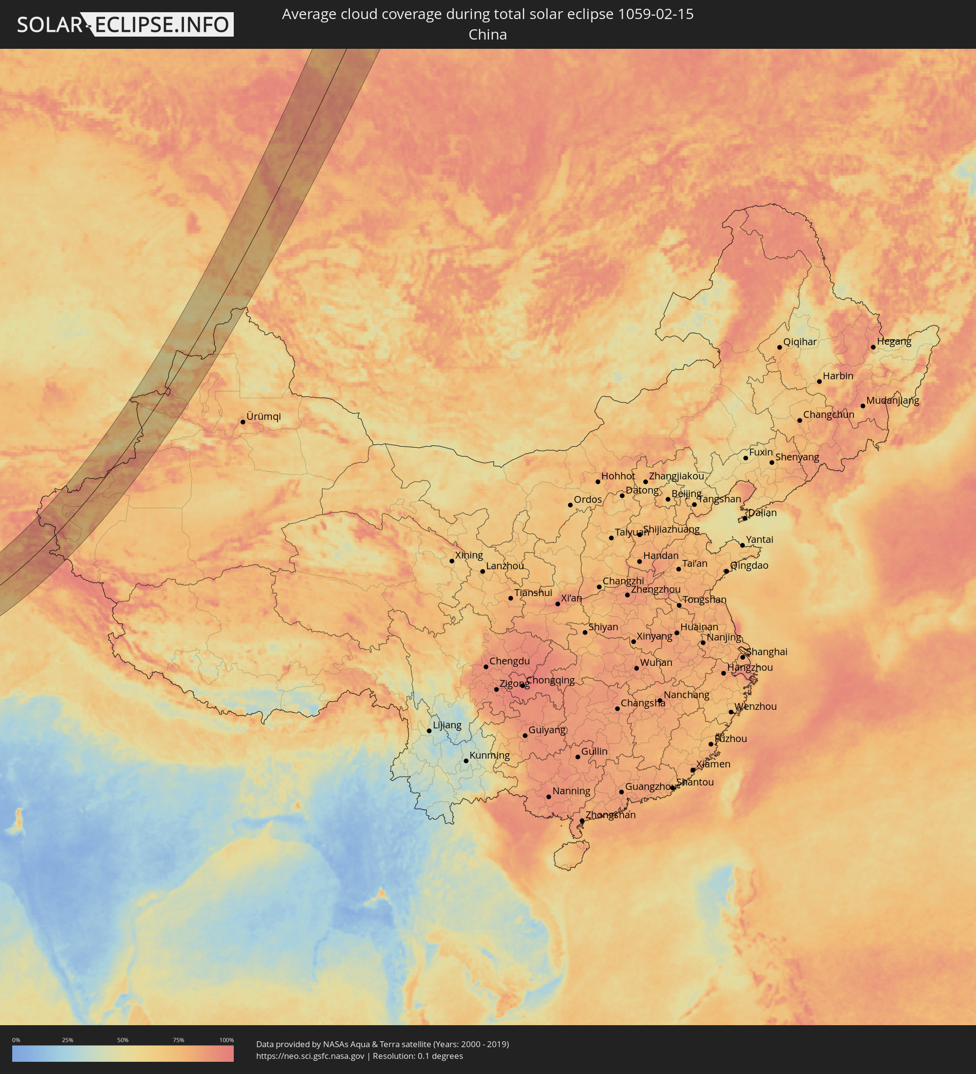 China
China
Cities inside the path of the eclipse
The following table shows all locations with a population of more than 5,000 inside the eclipse path. Cities which have more than 100,000 inhabitants are marked bold. A click at the locations opens a detailed map.
| City | Type | Eclipse duration | Local time of max. eclipse | Distance to central line | Ø Cloud coverage |
|
Turaif, Northern Borders
|
total | - | 07:17:37 UTC+03:06 | 80 km | 50% |
|
Sakakah, Al Jawf
|
total | - | 07:15:29 UTC+03:06 | 77 km | 35% |
|
Şuwayr, Al Jawf
|
total | - | 07:15:47 UTC+03:06 | 57 km | 35% |
|
‘Ar‘ar, Northern Borders
|
total | - | 07:17:22 UTC+03:06 | 48 km | 40% |
|
Nāḩiyat al Fuhūd, Dhi Qar
|
total | - | 07:10:53 UTC+02:57 | 120 km | 59% |
|
Al Jahrā’, Al Jahrāʼ
|
total | - | 07:18:03 UTC+03:06 | 54 km | 54% |
|
Az Zubayr, Basra Governorate
|
total | - | 07:10:32 UTC+02:57 | 63 km | 58% |
|
Al Hārithah, Basra Governorate
|
total | - | 07:10:53 UTC+02:57 | 85 km | 60% |
|
Basrah, Basra Governorate
|
total | - | 07:10:46 UTC+02:57 | 76 km | 54% |
|
Al Başrah al Qadīmah, Basra Governorate
|
total | - | 07:10:47 UTC+02:57 | 76 km | 54% |
|
Umm Qaşr, Basra Governorate
|
total | - | 07:10:05 UTC+02:57 | 25 km | 57% |
|
Ar Rābiyah, Al Asimah
|
total | - | 07:18:09 UTC+03:06 | 58 km | 58% |
|
Al Farwānīyah, Al Farwaniyah
|
total | - | 07:18:08 UTC+03:06 | 59 km | 55% |
|
Ash Shāmīyah, Al Asimah
|
total | - | 07:18:15 UTC+03:06 | 52 km | 55% |
|
Janūb as Surrah, Al Farwaniyah
|
total | - | 07:18:08 UTC+03:06 | 60 km | 55% |
|
Kuwait City, Al Asimah
|
total | - | 07:18:18 UTC+03:06 | 49 km | 54% |
|
Ad Dasmah, Al Asimah
|
total | - | 07:18:18 UTC+03:06 | 49 km | 54% |
|
Ḩawallī, Hawalli
|
total | - | 07:18:16 UTC+03:06 | 53 km | 55% |
|
Bayān, Hawalli
|
total | - | 07:18:14 UTC+03:06 | 56 km | 55% |
|
Şabāḩ as Sālim, Mubārak al Kabīr
|
total | - | 07:18:10 UTC+03:06 | 61 km | 53% |
|
Ar Rumaythīyah, Hawalli
|
total | - | 07:18:16 UTC+03:06 | 55 km | 53% |
|
Salwá, Hawalli
|
total | - | 07:18:15 UTC+03:06 | 57 km | 53% |
|
Al Aḩmadī, Al Aḩmadī
|
total | - | 07:17:53 UTC+03:06 | 81 km | 53% |
|
Ar Riqqah, Al Aḩmadī
|
total | - | 07:18:01 UTC+03:06 | 73 km | 53% |
|
Al Finţās, Al Aḩmadī
|
total | - | 07:18:04 UTC+03:06 | 70 km | 52% |
|
Al Faḩāḩīl, Al Aḩmadī
|
total | - | 07:17:56 UTC+03:06 | 80 km | 53% |
|
Al Mahbūlah, Al Aḩmadī
|
total | - | 07:18:02 UTC+03:06 | 73 km | 53% |
|
Al Manqaf, Al Aḩmadī
|
total | - | 07:17:57 UTC+03:06 | 79 km | 53% |
|
Khorramshahr, Khuzestan
|
total | - | 07:39:03 UTC+03:25 | 71 km | 59% |
|
Az Zawr, Al Asimah
|
total | - | 07:18:36 UTC+03:06 | 39 km | 41% |
|
Abadan, Khuzestan
|
total | - | 07:38:57 UTC+03:25 | 60 km | 54% |
|
Al Fāw, Basra Governorate
|
total | - | 07:10:20 UTC+02:57 | 21 km | 60% |
|
Behbahān, Khuzestan
|
total | - | 07:40:41 UTC+03:25 | 95 km | 71% |
|
Dehdasht, Kohgīlūyeh va Būyer Aḩmad
|
total | - | 07:41:15 UTC+03:25 | 117 km | 62% |
|
Dogonbadan, Kohgīlūyeh va Būyer Aḩmad
|
total | - | 07:40:41 UTC+03:25 | 69 km | 66% |
|
Bandar-e Būshehr, Bushehr
|
total | - | 07:38:25 UTC+03:25 | 86 km | 59% |
|
Borāzjān, Bushehr
|
total | - | 07:39:11 UTC+03:25 | 53 km | 77% |
|
Nūrābād, Fars
|
total | - | 07:40:49 UTC+03:25 | 41 km | 69% |
|
Yasuj, Kohgīlūyeh va Būyer Aḩmad
|
total | - | 07:41:48 UTC+03:25 | 102 km | 70% |
|
Kāzerūn, Fars
|
total | - | 07:40:06 UTC+03:25 | 14 km | 72% |
|
Shiraz, Fars
|
total | - | 07:40:45 UTC+03:25 | 18 km | 56% |
|
Fīrūzābād, Fars
|
total | - | 07:39:30 UTC+03:25 | 103 km | 57% |
|
Akbarābād, Fars
|
total | - | 07:40:20 UTC+03:25 | 60 km | 50% |
|
Fasā, Fars
|
total | - | 07:40:31 UTC+03:25 | 99 km | 49% |
|
Sirjan, Kerman
|
total | - | 07:43:08 UTC+03:25 | 60 km | 51% |
|
Rafsanjān, Kerman
|
total | - | 07:45:02 UTC+03:25 | 41 km | 49% |
|
Kerman, Kerman
|
total | - | 07:45:51 UTC+03:25 | 12 km | 57% |
|
Bam, Kerman
|
total | - | 07:45:04 UTC+03:25 | 139 km | 39% |
|
Zābol, Sistan and Baluchestan
|
total | - | 07:51:43 UTC+03:25 | 4 km | 58% |
|
Zaranj, Nimroz
|
total | - | 08:26:16 UTC+04:00 | 22 km | 59% |
|
Farah, Farah
|
total | - | 08:29:02 UTC+04:00 | 119 km | 59% |
|
Khāsh, Nimroz
|
total | - | 08:28:19 UTC+04:00 | 9 km | 44% |
|
Lashkar Gāh, Helmand
|
total | - | 08:30:19 UTC+04:00 | 40 km | 59% |
|
Gereshk, Helmand
|
total | - | 08:30:57 UTC+04:00 | 24 km | 58% |
|
Kandahār, Kandahar
|
total | - | 08:32:00 UTC+04:00 | 89 km | 59% |
|
Bāmyān, Bamyan
|
total | - | 08:40:22 UTC+04:00 | 127 km | 77% |
|
Ghazni, Ghazni
|
total | - | 08:38:55 UTC+04:00 | 21 km | 61% |
|
Barakī Barak, Logar
|
total | - | 08:40:21 UTC+04:00 | 9 km | 59% |
|
Paghmān, Kabul
|
total | - | 08:41:26 UTC+04:00 | 49 km | 68% |
|
Charikar, Parwan
|
total | - | 08:42:29 UTC+04:00 | 76 km | 66% |
|
Kabul, Kabul
|
total | - | 08:41:38 UTC+04:00 | 32 km | 70% |
|
Gardēz, Paktia
|
total | - | 08:40:04 UTC+04:00 | 57 km | 64% |
|
Bāzārak, Panjshir
|
total | - | 08:43:28 UTC+04:00 | 85 km | 74% |
|
Khōst, Khowst
|
total | - | 08:40:34 UTC+04:00 | 116 km | 53% |
|
Parachinar, Federally Administered Tribal Areas
|
total | - | 09:10:00 UTC+04:28 | 74 km | 58% |
|
Mehtar Lām, Laghman
|
total | - | 08:43:17 UTC+04:00 | 10 km | 67% |
|
Jalālābād, Nangarhar
|
total | - | 08:43:12 UTC+04:00 | 45 km | 65% |
|
Doāba, Khyber Pakhtunkhwa
|
total | - | 09:10:02 UTC+04:28 | 151 km | 59% |
|
Asadābād, Kunar
|
total | - | 08:44:56 UTC+04:00 | 43 km | 69% |
|
Āsmār, Kunar
|
total | - | 08:45:30 UTC+04:00 | 41 km | 74% |
|
Shabqadar, Khyber Pakhtunkhwa
|
total | - | 09:12:34 UTC+04:28 | 124 km | 63% |
|
Peshawar, Khyber Pakhtunkhwa
|
total | - | 09:12:14 UTC+04:28 | 144 km | 65% |
|
Ishqoshim, Gorno-Badakhshan
|
total | - | 09:23:59 UTC+04:35 | 90 km | 81% |
|
Tangi, Khyber Pakhtunkhwa
|
total | - | 09:12:51 UTC+04:28 | 122 km | 62% |
|
Chārsadda, Khyber Pakhtunkhwa
|
total | - | 09:12:42 UTC+04:28 | 141 km | 61% |
|
Utmānzai, Khyber Pakhtunkhwa
|
total | - | 09:12:48 UTC+04:28 | 138 km | 62% |
|
Upper Dir, Khyber Pakhtunkhwa
|
total | - | 09:14:44 UTC+04:28 | 55 km | 74% |
|
Bat Khela, Khyber Pakhtunkhwa
|
total | - | 09:13:51 UTC+04:28 | 112 km | 63% |
|
Tāl, Khyber Pakhtunkhwa
|
total | - | 09:15:43 UTC+04:28 | 53 km | 76% |
|
Mingora, Khyber Pakhtunkhwa
|
total | - | 09:14:41 UTC+04:28 | 120 km | 70% |
|
Murghob, Gorno-Badakhshan
|
total | - | 09:29:43 UTC+04:35 | 64 km | 82% |
|
Gilgit, Gilgit-Baltistan
|
total | - | 09:19:26 UTC+04:28 | 138 km | 83% |
|
Kashgar, Xinjiang Uyghur Autonomous Region
|
total | - | 12:59:32 UTC+08:00 | 33 km | 84% |
|
Shache, Xinjiang Uyghur Autonomous Region
|
total | - | 12:59:38 UTC+08:00 | 126 km | 85% |
|
Kyzyl-Suu, Issyk-Kul Region
|
total | - | 10:05:17 UTC+04:58 | 100 km | 73% |
|
Tyup, Issyk-Kul Region
|
total | - | 10:06:22 UTC+04:58 | 102 km | 56% |
|
Karakol, Issyk-Kul Region
|
total | - | 10:06:03 UTC+04:58 | 84 km | 59% |
|
Ak-Suu, Issyk-Kul Region
|
total | - | 10:06:15 UTC+04:58 | 76 km | 60% |
|
Kegen, Almaty Oblysy
|
total | - | 09:31:28 UTC+04:21 | 64 km | 56% |
|
Zharkent, Almaty Oblysy
|
total | - | 09:34:13 UTC+04:21 | 84 km | 71% |
|
Aykol, Xinjiang Uyghur Autonomous Region
|
total | - | 13:07:50 UTC+08:00 | 134 km | 86% |
|
Aksu, Xinjiang Uyghur Autonomous Region
|
total | - | 13:08:23 UTC+08:00 | 128 km | 83% |
|
Kurchum, East Kazakhstan
|
total | - | 09:44:53 UTC+04:21 | 98 km | 59% |
|
Aksuat
|
total | - | 09:45:07 UTC+04:21 | 104 km | 57% |
|
Tūghyl, East Kazakhstan
|
total | - | 09:44:35 UTC+04:21 | 17 km | 57% |
|
Zyryanovsk, East Kazakhstan
|
total | - | 09:47:02 UTC+04:21 | 122 km | 59% |
|
Zaysan, East Kazakhstan
|
total | - | 09:45:09 UTC+04:21 | 41 km | 54% |
|
Myski, Kemerovo
|
total | - | 11:44:57 UTC+06:11 | 106 km | 82% |
|
Tashtagol, Kemerovo
|
total | - | 11:44:10 UTC+06:11 | 54 km | 73% |
|
Mezhdurechensk, Kemerovo
|
total | - | 11:45:14 UTC+06:11 | 90 km | 78% |
|
Sharypovo, Krasnoyarskiy
|
total | - | 11:48:05 UTC+06:11 | 113 km | 81% |
|
Uzhur, Krasnoyarskiy
|
total | - | 11:48:35 UTC+06:11 | 66 km | 81% |
|
Abaza, Khakasiya
|
total | - | 11:46:40 UTC+06:11 | 83 km | 85% |
|
Sorsk, Khakasiya
|
total | - | 11:47:59 UTC+06:11 | 23 km | 81% |
|
Nazarovo, Krasnoyarskiy
|
total | - | 11:49:45 UTC+06:11 | 67 km | 82% |
|
Achinsk, Krasnoyarskiy
|
total | - | 11:50:02 UTC+06:11 | 74 km | 88% |
|
Chernogorsk, Khakasiya
|
total | - | 11:49:01 UTC+06:11 | 92 km | 86% |
|
Abakan, Khakasiya
|
total | - | 11:49:06 UTC+06:11 | 106 km | 88% |
|
Yeniseysk, Krasnoyarskiy
|
total | - | 11:53:15 UTC+06:11 | 84 km | 89% |
|
Divnogorsk, Krasnoyarskiy
|
total | - | 11:51:49 UTC+06:11 | 46 km | 86% |
|
Lesosibirsk, Krasnoyarskiy
|
total | - | 11:53:25 UTC+06:11 | 58 km | 87% |
|
Yemel’yanovo, Krasnoyarskiy
|
total | - | 11:52:17 UTC+06:11 | 52 km | 83% |
|
Krasnoyarsk, Krasnoyarskiy
|
total | - | 11:52:23 UTC+06:11 | 70 km | 87% |
|
Berëzovka, Krasnoyarskiy
|
total | - | 11:52:39 UTC+06:11 | 83 km | 85% |
|
Sosnovoborsk, Krasnoyarskiy
|
total | - | 11:52:58 UTC+06:11 | 91 km | 87% |
|
Zheleznogorsk, Krasnoyarskiy
|
total | - | 11:53:15 UTC+06:11 | 95 km | 88% |