Total solar eclipse of 03/19/1094
| Day of week: | Monday |
| Maximum duration of eclipse: | 03m04s |
| Maximum width of eclipse path: | 118 km |
| Saros cycle: | 105 |
| Coverage: | 100% |
| Magnitude: | 1.035 |
| Gamma: | 0.0862 |
Wo kann man die Sonnenfinsternis vom 03/19/1094 sehen?
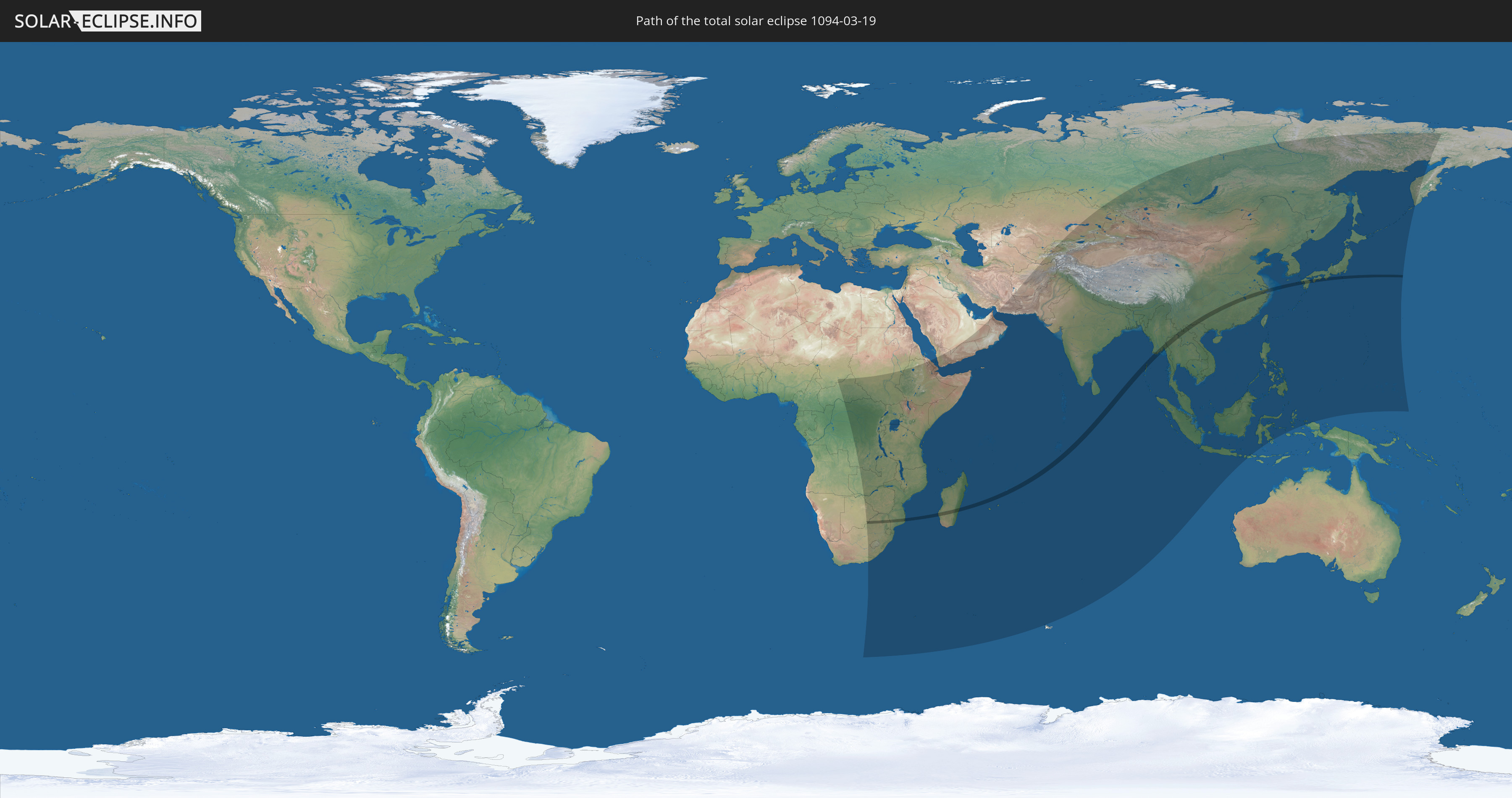
Die Sonnenfinsternis am 03/19/1094 kann man in 71 Ländern als partielle Sonnenfinsternis beobachten.
Der Finsternispfad verläuft durch 11 Länder. Nur in diesen Ländern ist sie als total Sonnenfinsternis zu sehen.
In den folgenden Ländern ist die Sonnenfinsternis total zu sehen
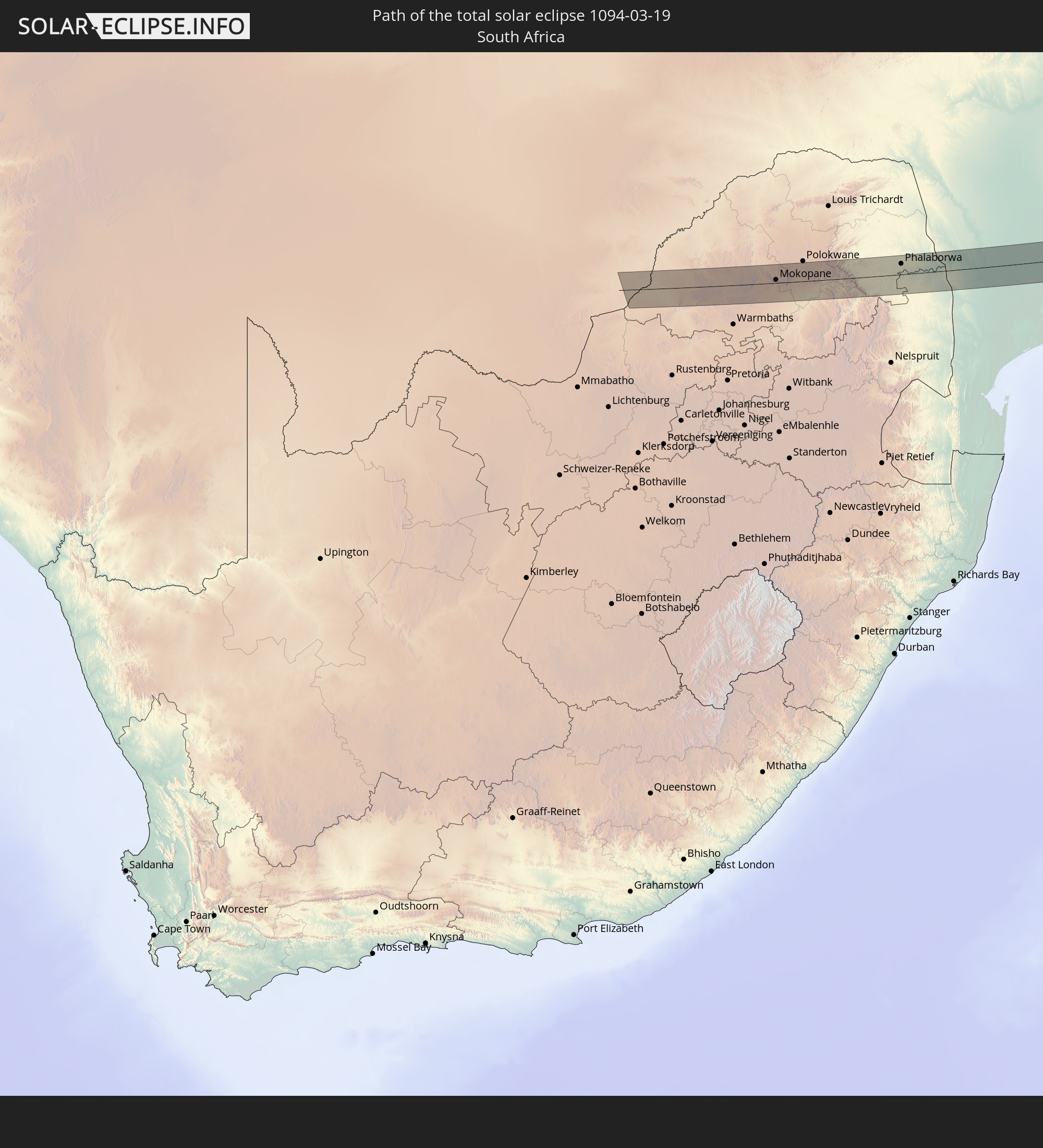 South Africa
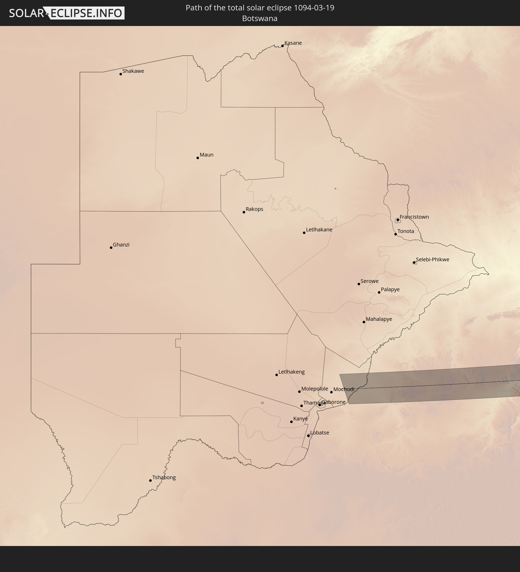 Botswana
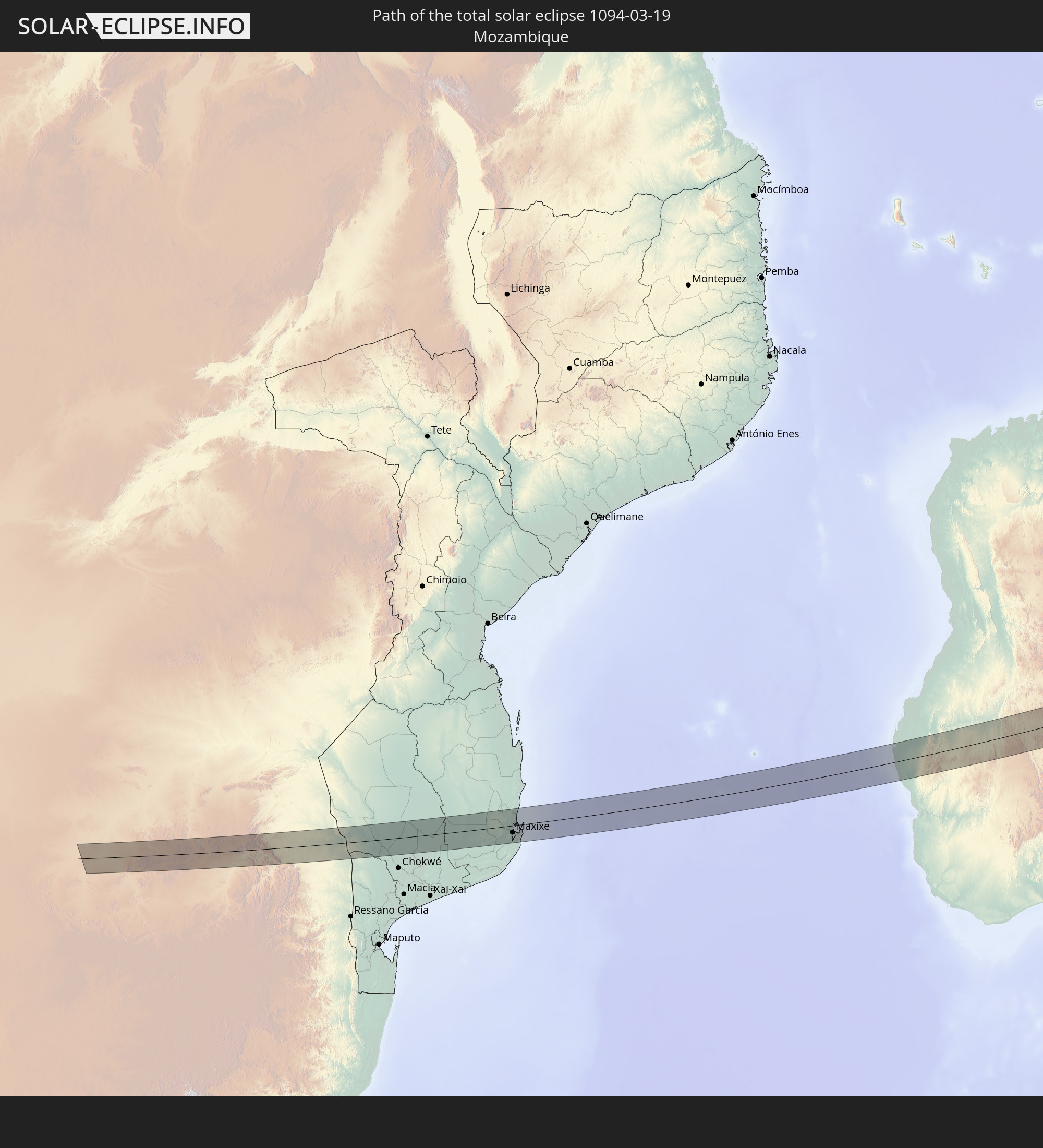 Mozambique
 Madagascar
 India
India
 China
China
 Myanmar
 Thailand
 Laos
Laos
 Vietnam
 Japan
Japan
In den folgenden Ländern ist die Sonnenfinsternis partiell zu sehen
 Russia
 Democratic Republic of the Congo
 Chad
Chad
 Central African Republic
 South Africa
 Botswana
 Sudan
Sudan
 Zambia
 Zimbabwe
 Lesotho
 Rwanda
 Burundi
 Tanzania
 Uganda
 Mozambique
 Swaziland
 Malawi
 Ethiopia
 Kenya
Kenya
 Saudi Arabia
 Eritrea
 French Southern and Antarctic Lands
 Somalia
 Djibouti
 Yemen
Yemen
 Madagascar
 Comoros
 Iran
Iran
 Mayotte
 Seychelles
 Kazakhstan
 United Arab Emirates
 Oman
Oman
 Réunion
 Uzbekistan
 Mauritius
 Afghanistan
 Pakistan
 Tajikistan
 India
India
 Kyrgyzstan
 British Indian Ocean Territory
 Maldives
 China
China
 Sri Lanka
 Nepal
Nepal
 Mongolia
 Bangladesh
 Bhutan
 Myanmar
 Indonesia
 Cocos Islands
 Thailand
 Malaysia
 Laos
Laos
 Vietnam
 Cambodia
 Singapore
 Christmas Island
 Macau
Macau
 Hong Kong
 Brunei
 Taiwan
 Philippines
 Japan
Japan
 North Korea
 South Korea
 Palau
Palau
 Federated States of Micronesia
 Guam
Guam
 Northern Mariana Islands
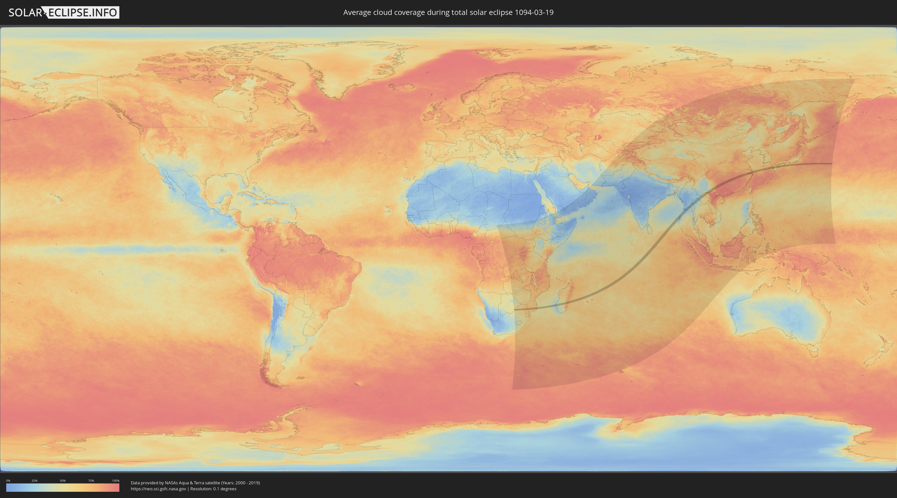
How will be the weather during the total solar eclipse on 03/19/1094?
Where is the best place to see the total solar eclipse of 03/19/1094?
The following maps show the average cloud coverage for the day of the total solar eclipse.
With the help of these maps, it is possible to find the place along the eclipse path, which has the best
chance of a cloudless sky.
Nevertheless, you should consider local circumstances and inform about the weather of your chosen
observation site.
The data is provided by NASAs satellites
AQUA and TERRA.
The cloud maps are averaged over a period of 19 years (2000 - 2019).

Detailed country maps
 South Africa
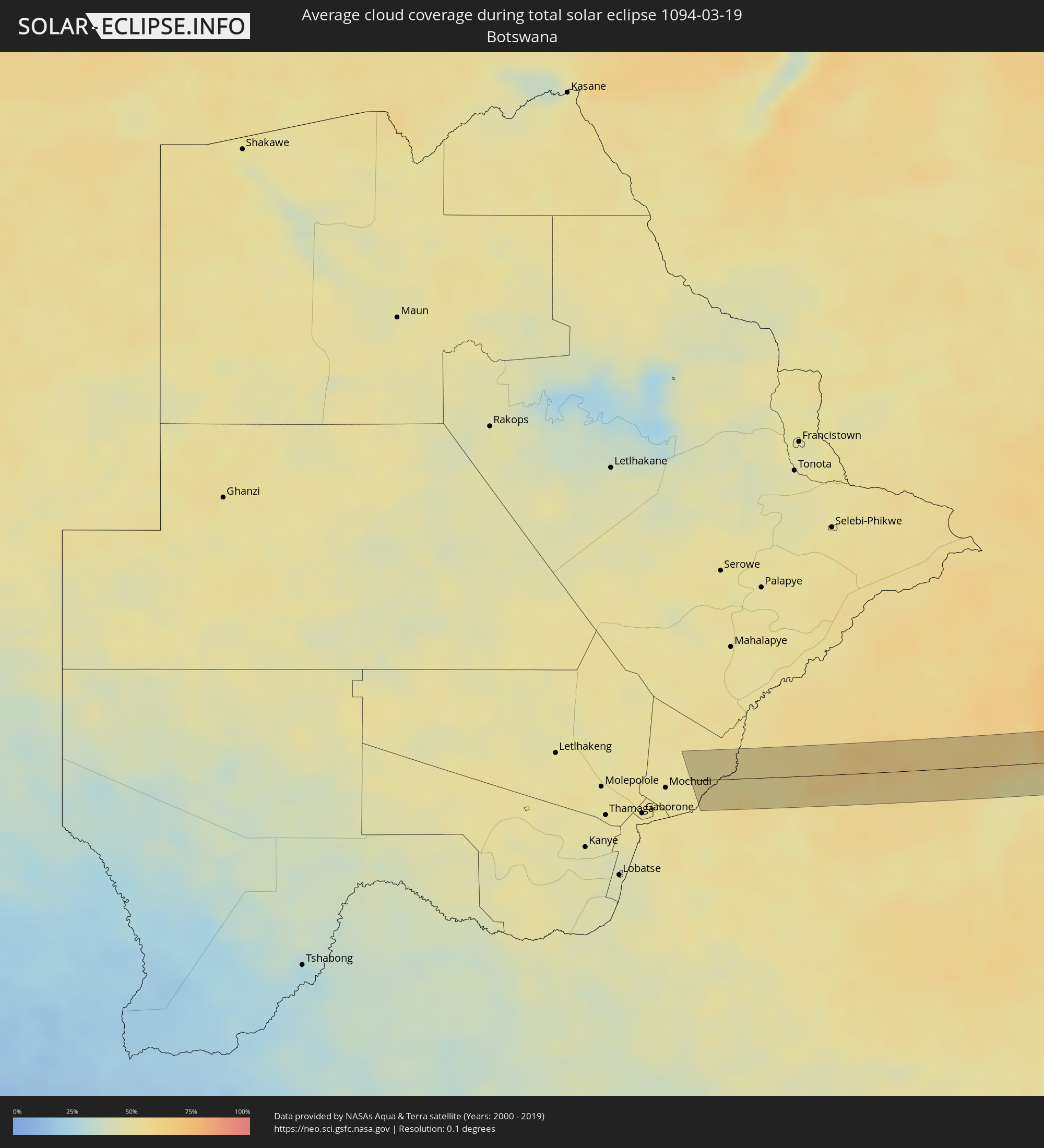 Botswana
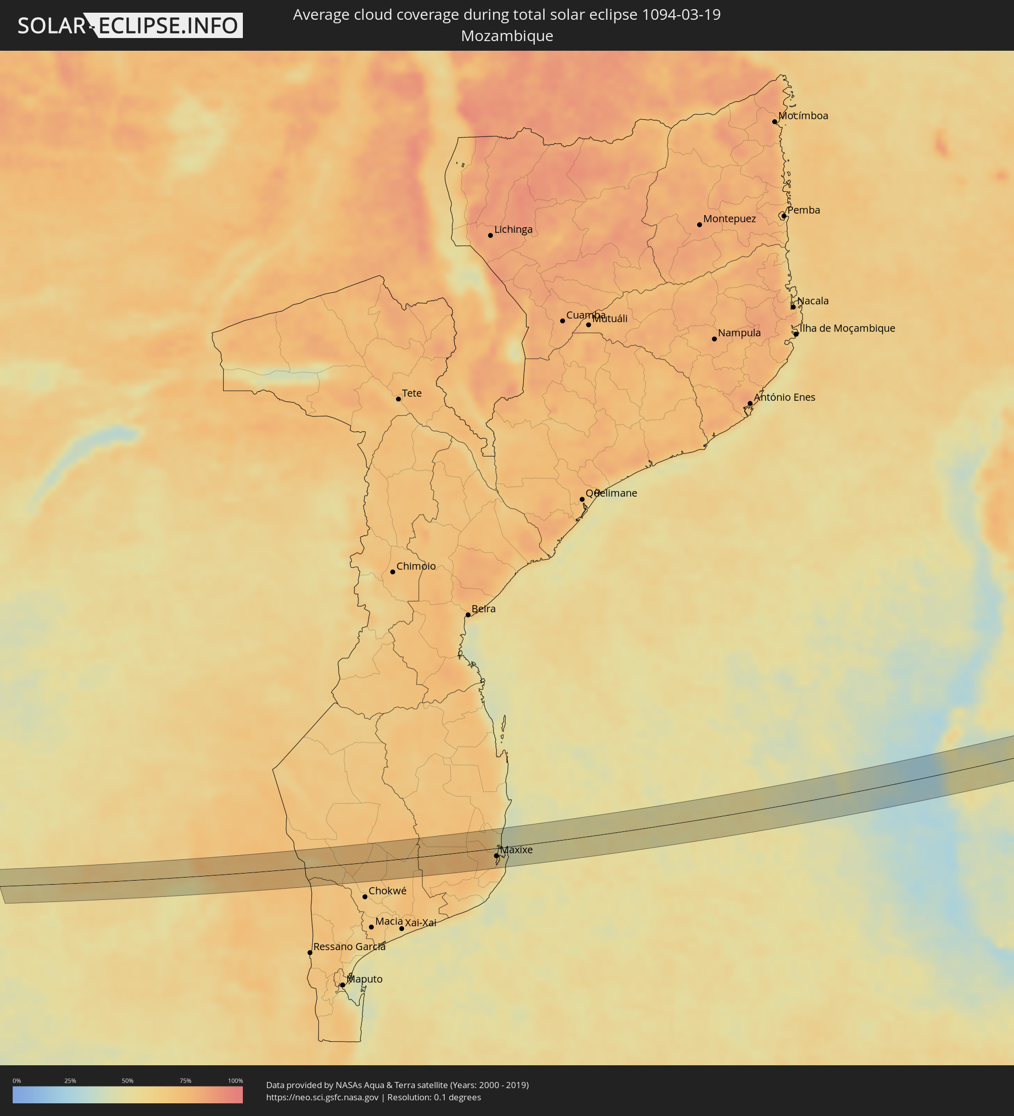 Mozambique
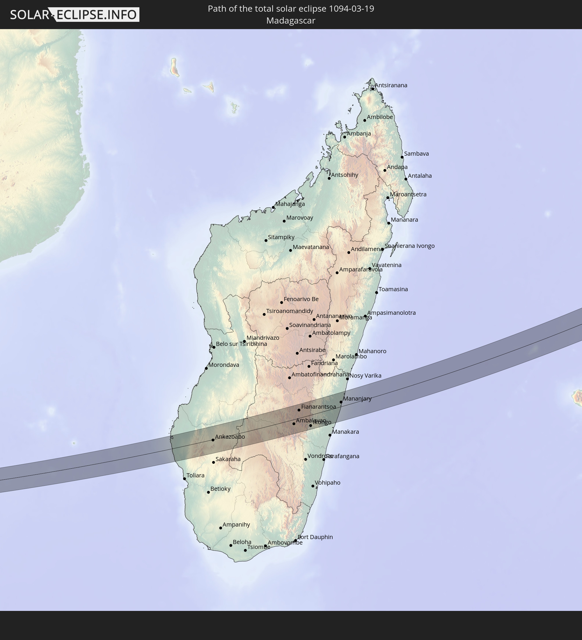
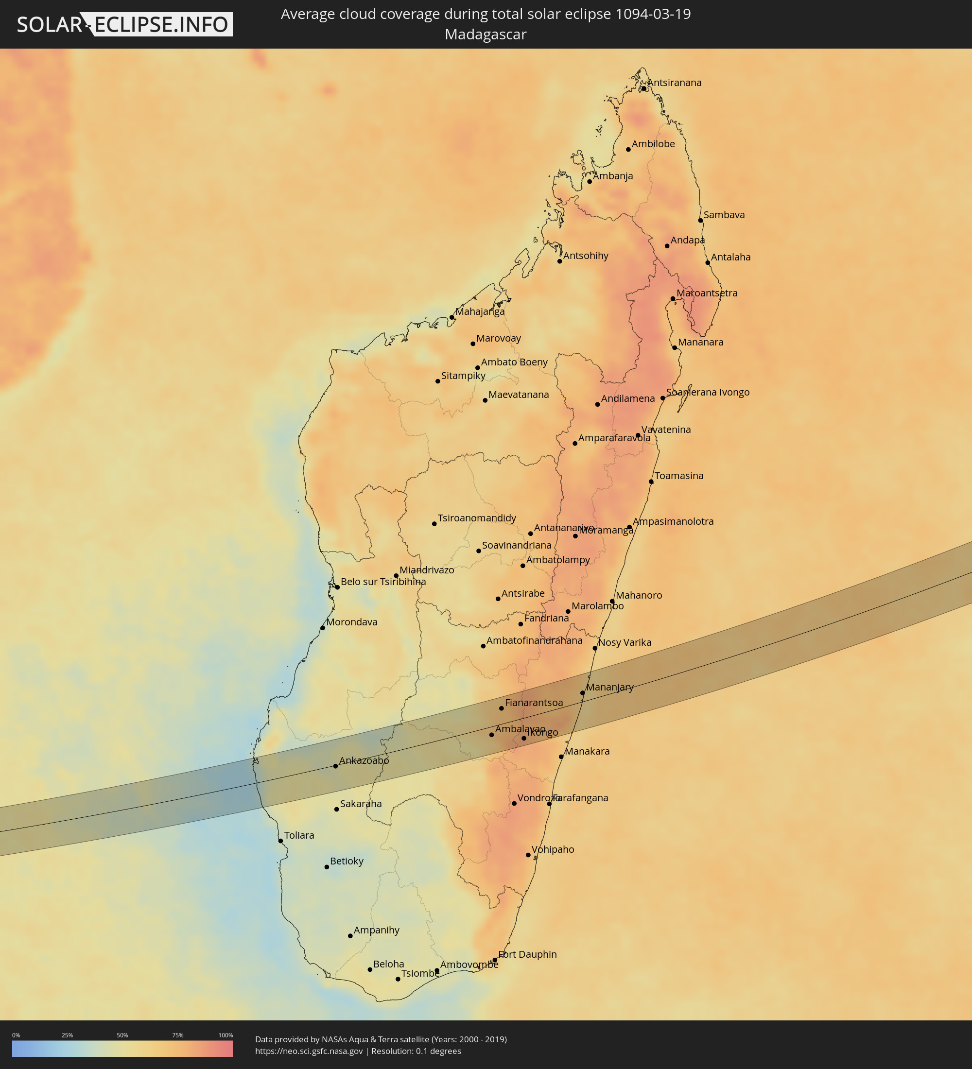 Madagascar
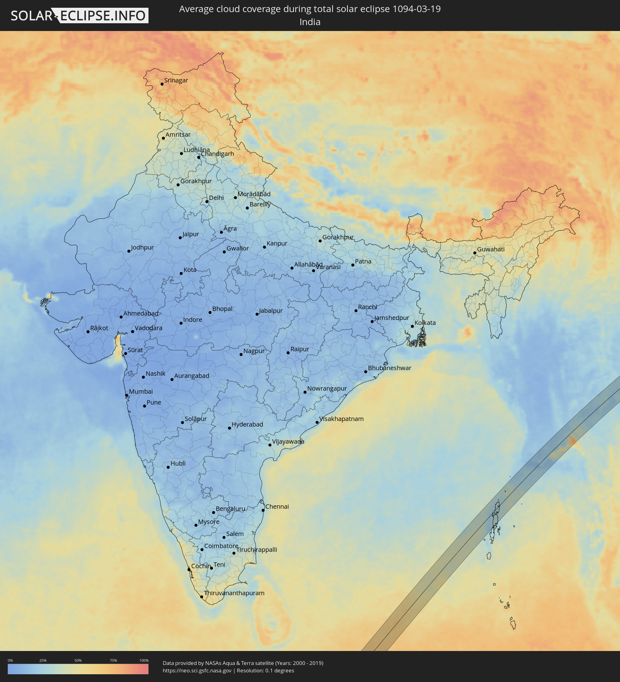 India
India
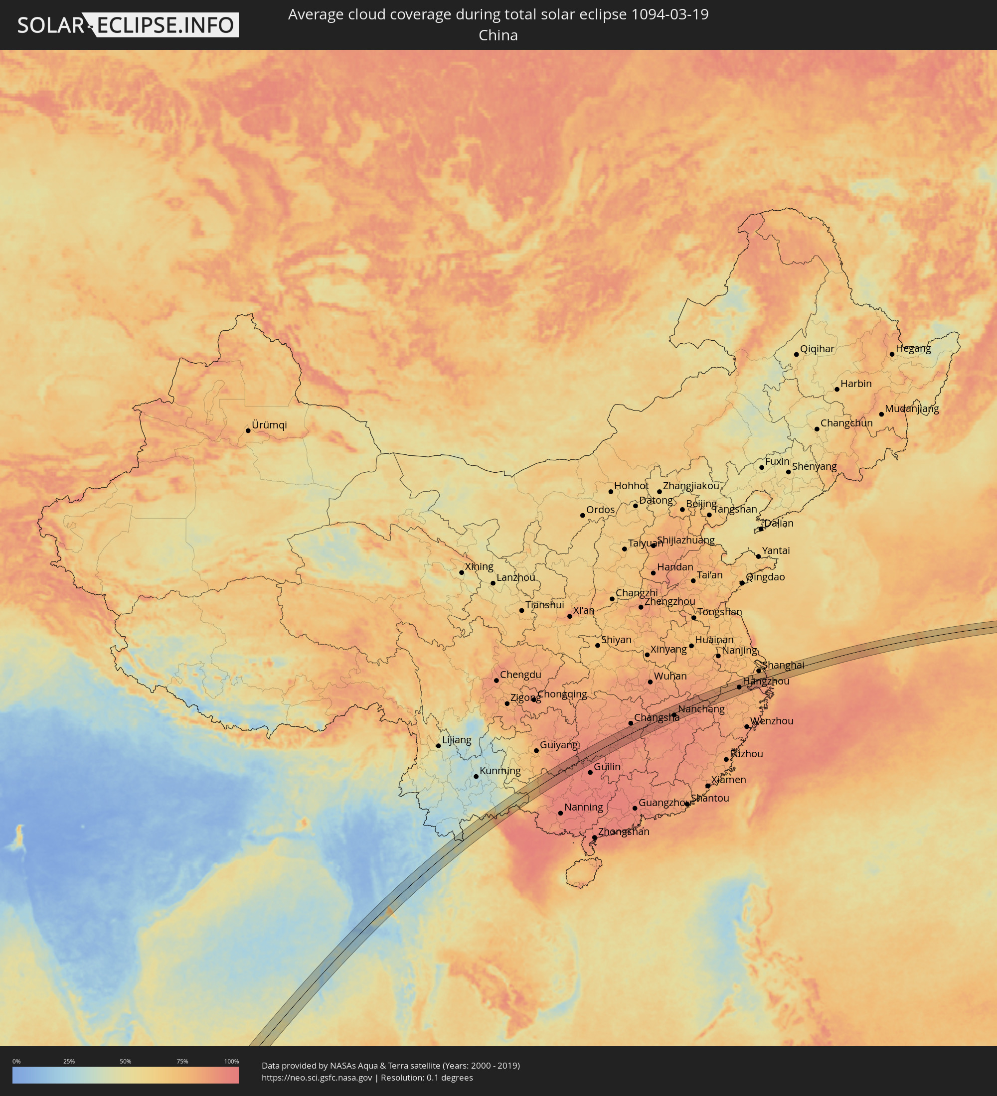 China
China
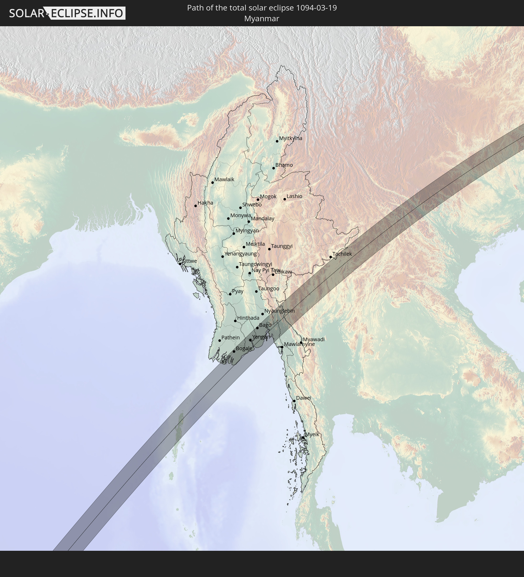
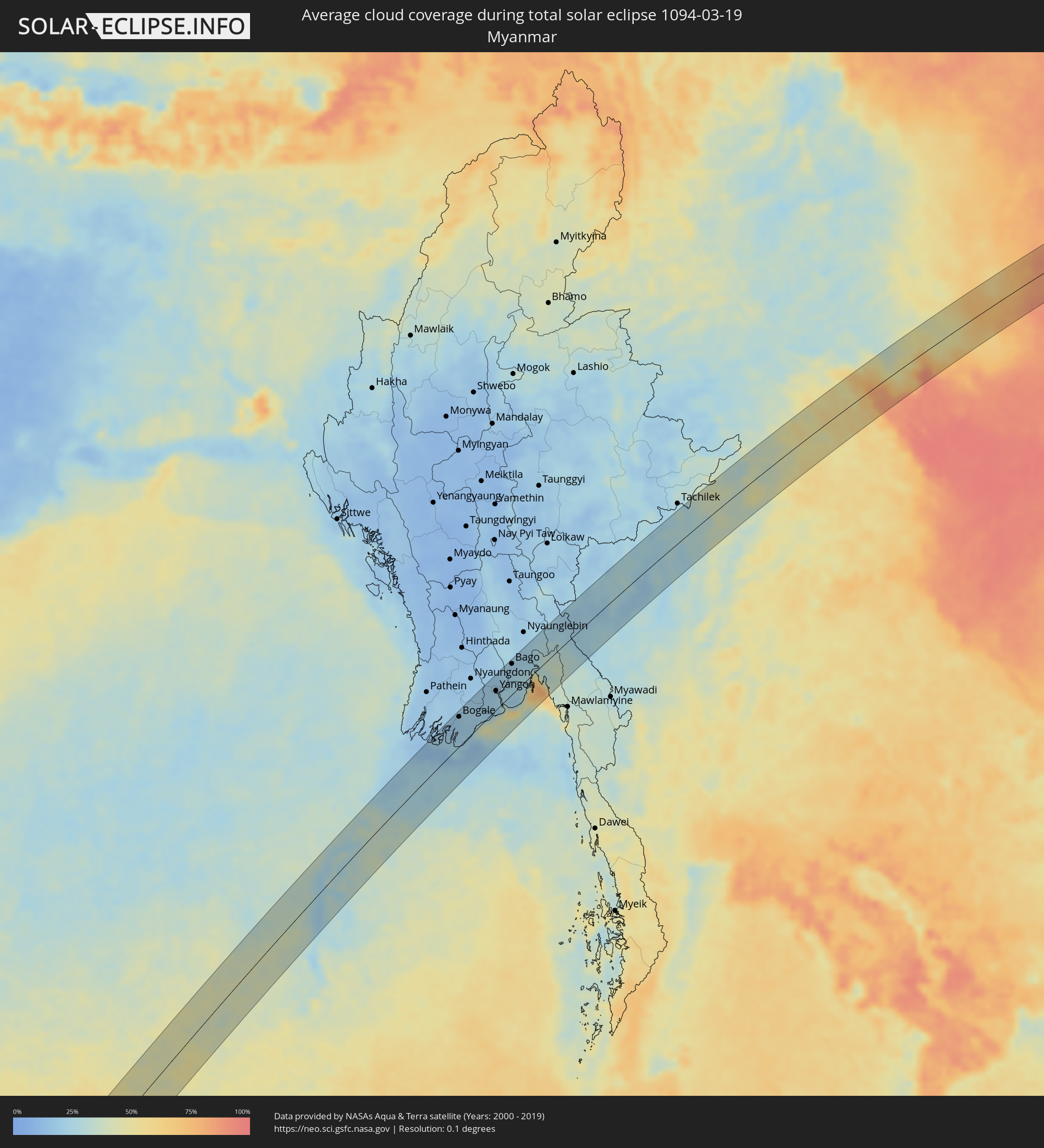 Myanmar
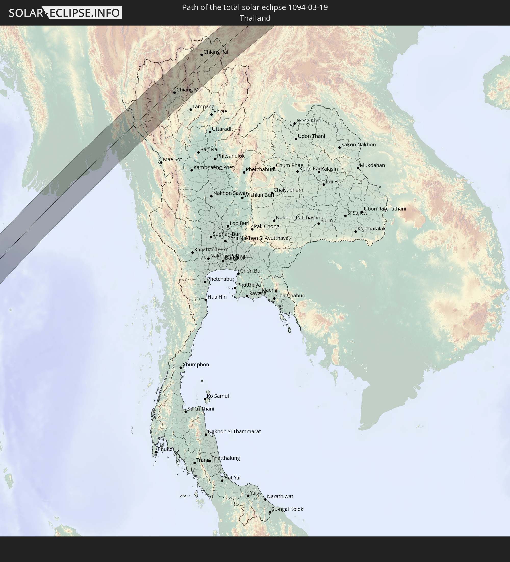
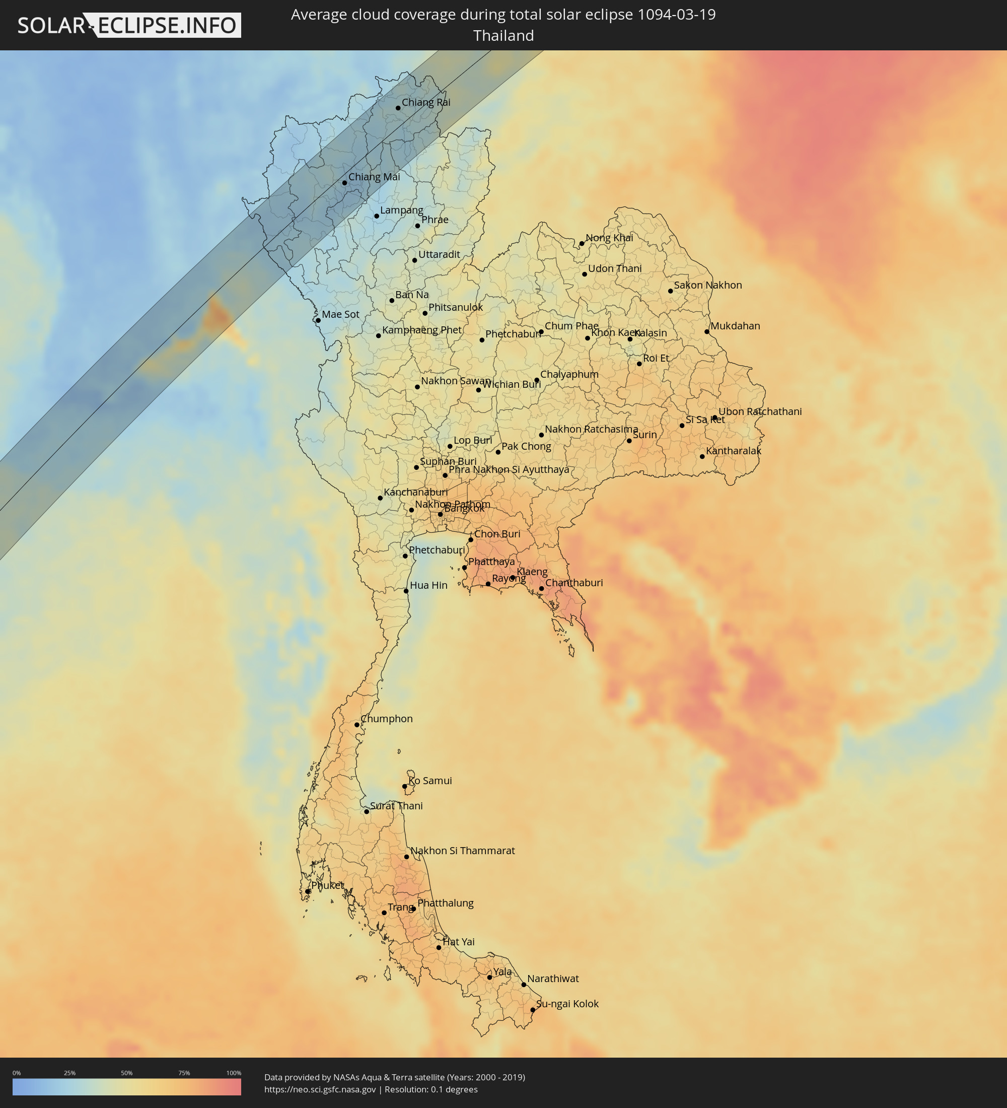 Thailand
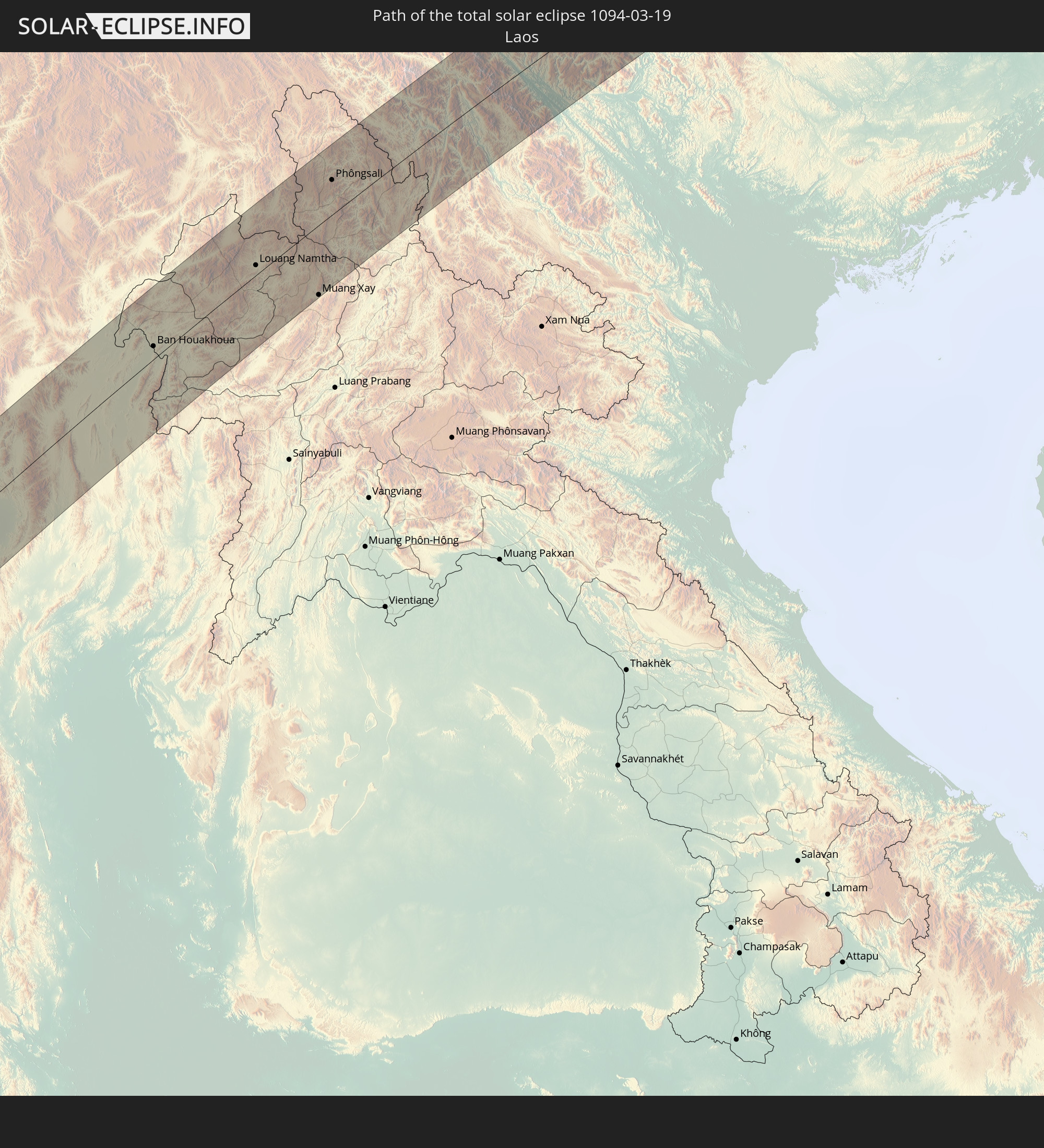
 Laos
Laos
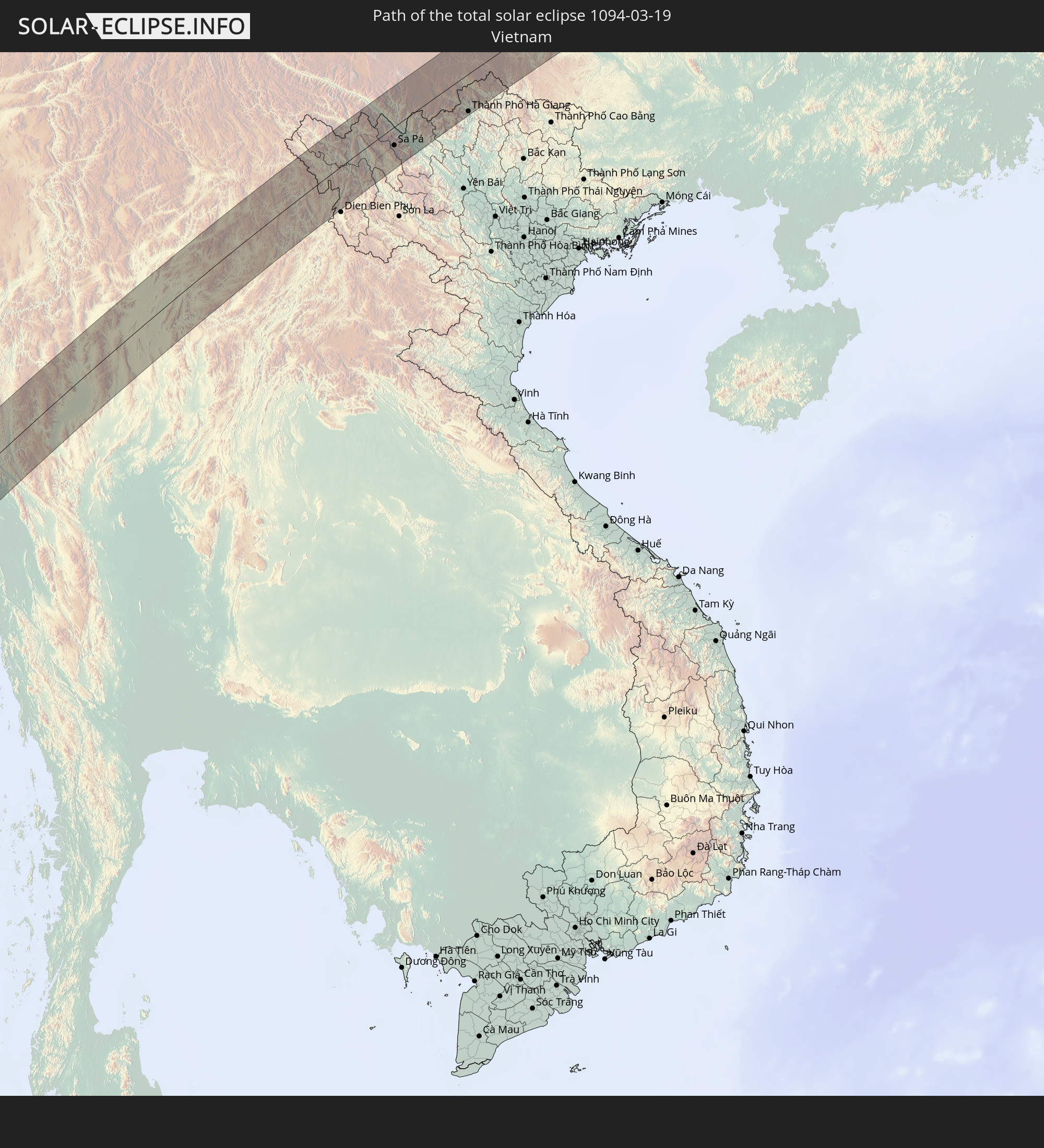
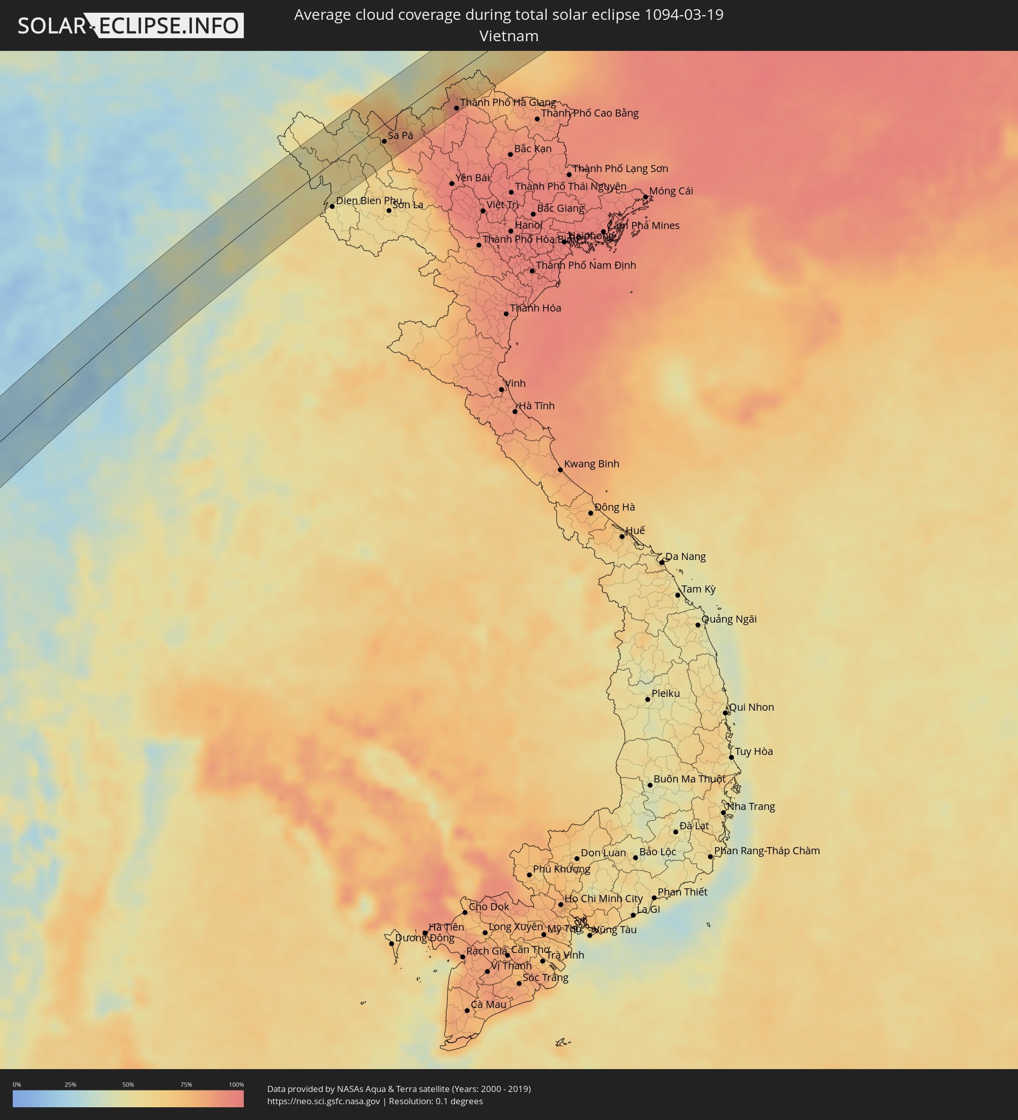 Vietnam
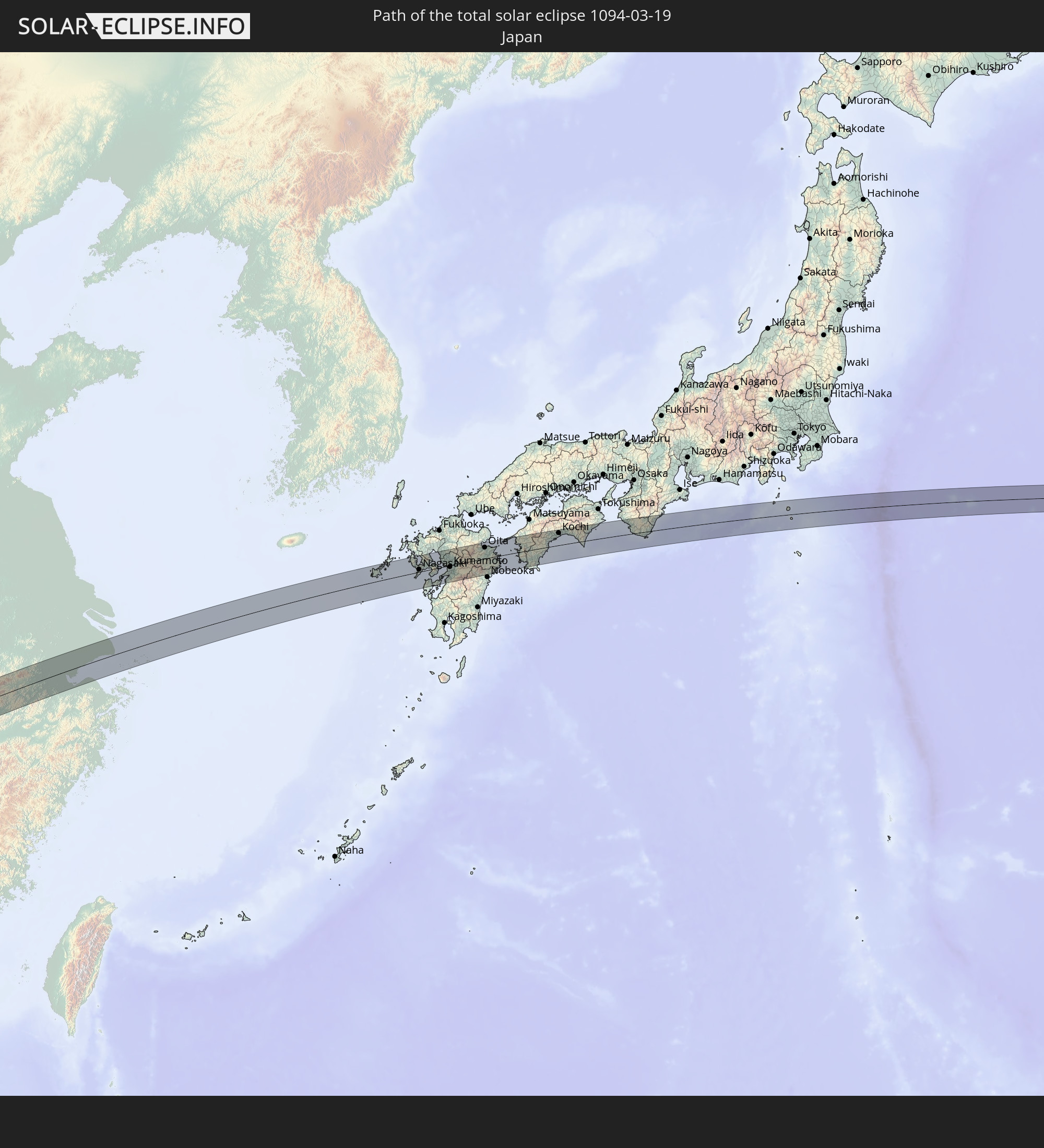
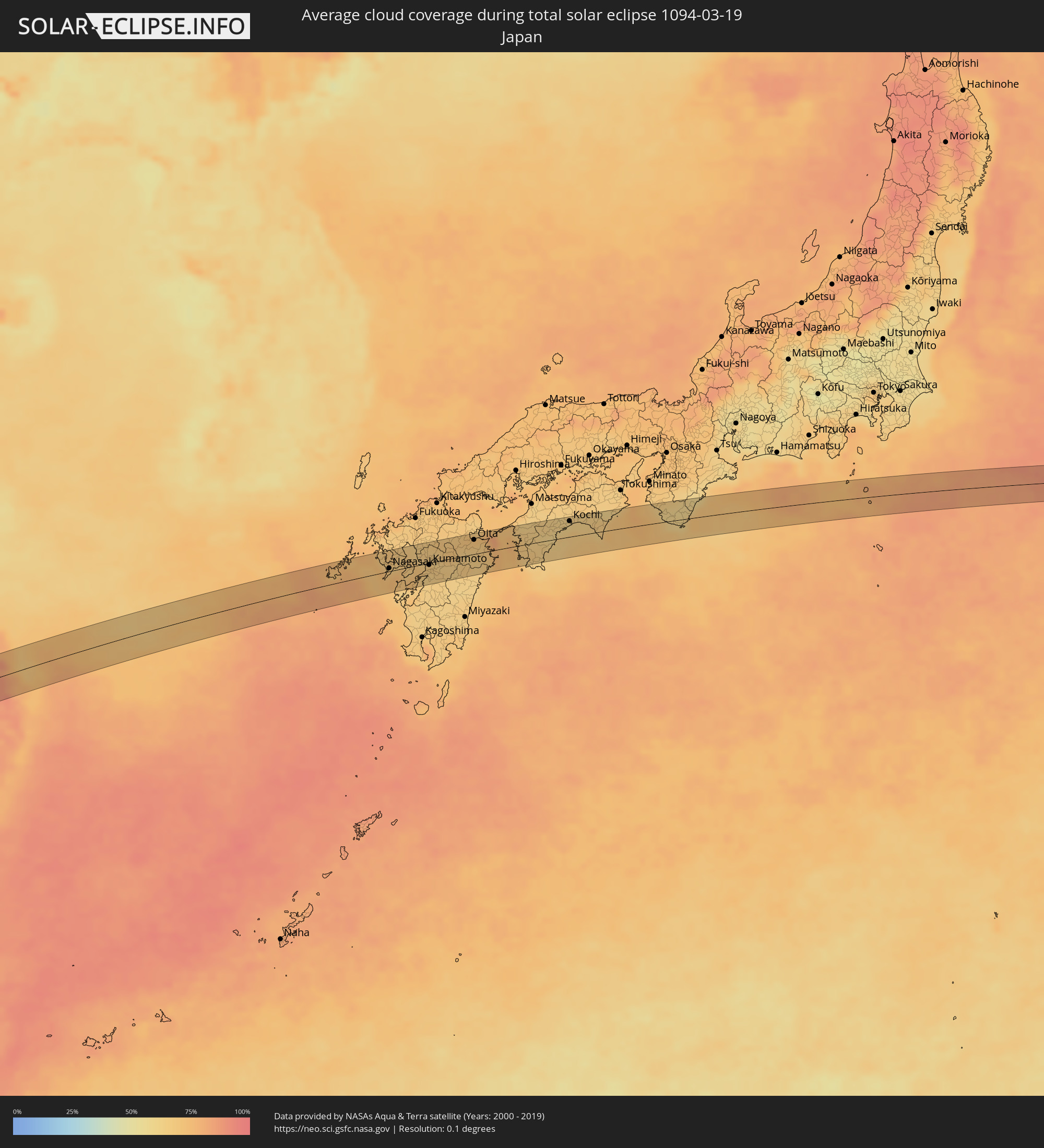 Japan
Japan
Cities inside the path of the eclipse
The following table shows all locations with a population of more than 5,000 inside the eclipse path. Cities which have more than 100,000 inhabitants are marked bold. A click at the locations opens a detailed map.
| City | Type | Eclipse duration | Local time of max. eclipse | Distance to central line | Ø Cloud coverage |
|
Thabazimbi, Limpopo
|
total | - | 05:54:10 UTC+01:30 | 31 km | 50% |
|
Mokopane, Limpopo
|
total | - | 05:54:19 UTC+01:30 | 5 km | 58% |
|
Lebowakgomo, Limpopo
|
total | - | 05:54:21 UTC+01:30 | 2 km | 56% |
|
Nkowakowa, Limpopo
|
total | - | 05:54:29 UTC+01:30 | 31 km | 68% |
|
Phalaborwa, Limpopo
|
total | - | 05:54:34 UTC+01:30 | 18 km | 69% |
|
Maxixe, Inhambane
|
total | - | 06:35:41 UTC+02:10 | 15 km | 68% |
|
Inhambane, Inhambane
|
total | - | 06:35:41 UTC+02:10 | 16 km | 65% |
|
Ankazoabo, Atsimo-Andrefana
|
total | - | 06:56:41 UTC+02:27 | 3 km | 44% |
|
Ambalavao, Upper Matsiatra
|
total | - | 06:58:16 UTC+02:27 | 14 km | 59% |
|
Fianarantsoa, Upper Matsiatra
|
total | - | 06:58:34 UTC+02:27 | 23 km | 71% |
|
Fandrandava, Upper Matsiatra
|
total | - | 06:58:38 UTC+02:27 | 12 km | 75% |
|
Ikongo, Vatovavy Fitovinany
|
total | - | 06:58:33 UTC+02:27 | 33 km | 81% |
|
Ifanadiana, Vatovavy Fitovinany
|
total | - | 06:59:00 UTC+02:27 | 25 km | 78% |
|
Vohimanitra, Vatovavy Fitovinany
|
total | - | 06:58:49 UTC+02:27 | 20 km | 74% |
|
Mananjary, Vatovavy Fitovinany
|
total | - | 06:59:30 UTC+02:27 | 12 km | 63% |
|
Bogale, Ayeyarwady
|
total | - | 13:11:34 UTC+06:24 | 46 km | 18% |
|
Pyapon, Ayeyarwady
|
total | - | 13:12:03 UTC+06:24 | 24 km | 20% |
|
Kyaiklat, Ayeyarwady
|
total | - | 13:12:25 UTC+06:24 | 33 km | 20% |
|
Twante, Yangon
|
total | - | 13:13:16 UTC+06:24 | 39 km | 19% |
|
Kanbe, Yangon
|
total | - | 13:13:24 UTC+06:24 | 33 km | 21% |
|
Yangon, Yangon
|
total | - | 13:13:51 UTC+06:24 | 30 km | 24% |
|
Syriam, Yangon
|
total | - | 13:13:56 UTC+06:24 | 20 km | 24% |
|
Thanatpin, Bago
|
total | - | 13:14:50 UTC+06:24 | 51 km | 22% |
|
Bago, Bago
|
total | - | 13:15:22 UTC+06:24 | 48 km | 23% |
|
Thongwa, Yangon
|
total | - | 13:14:25 UTC+06:24 | 1 km | 22% |
|
Kayan, Yangon
|
total | - | 13:14:45 UTC+06:24 | 8 km | 26% |
|
Thanatpin, Bago
|
total | - | 13:15:27 UTC+06:24 | 38 km | 24% |
|
Kyaikto, Mon
|
total | - | 13:16:15 UTC+06:24 | 7 km | 33% |
|
Thaton, Mon
|
total | - | 13:16:11 UTC+06:24 | 51 km | 36% |
|
Pa Pae, Mae Hong Son
|
total | - | 13:36:59 UTC+06:42 | 9 km | 21% |
|
Chom Thong, Chiang Mai
|
total | - | 13:38:20 UTC+06:42 | 22 km | 20% |
|
San Pa Tong, Chiang Mai
|
total | - | 13:39:04 UTC+06:42 | 20 km | 19% |
|
Hang Dong, Chiang Mai
|
total | - | 13:39:13 UTC+06:42 | 17 km | 20% |
|
Pa Sang, Lamphun
|
total | - | 13:38:59 UTC+06:42 | 31 km | 21% |
|
Chiang Mai, Chiang Mai
|
total | - | 13:39:30 UTC+06:42 | 13 km | 20% |
|
Lamphun, Lamphun
|
total | - | 13:39:11 UTC+06:42 | 32 km | 20% |
|
San Kamphaeng, Chiang Mai
|
total | - | 13:39:39 UTC+06:42 | 26 km | 20% |
|
Mae Tha, Lamphun
|
total | - | 13:39:13 UTC+06:42 | 51 km | 25% |
|
Mae Chai, Phayao
|
total | - | 13:41:49 UTC+06:42 | 23 km | 27% |
|
Chiang Rai, Chiang Rai
|
total | - | 13:42:45 UTC+06:42 | 23 km | 28% |
|
Mae Chan, Chiang Rai
|
total | - | 13:43:09 UTC+06:42 | 42 km | 29% |
|
Phayao, Phayao
|
total | - | 13:41:40 UTC+06:42 | 41 km | 27% |
|
Pa Daet, Chiang Rai
|
total | - | 13:42:22 UTC+06:42 | 22 km | 24% |
|
Dok Kham Tai, Phayao
|
total | - | 13:41:49 UTC+06:42 | 51 km | 27% |
|
Chiang Saen, Chiang Rai
|
total | - | 13:43:45 UTC+06:42 | 37 km | 26% |
|
Chiang Kham, Phayao
|
total | - | 13:42:55 UTC+06:42 | 42 km | 33% |
|
Chiang Khong, Chiang Rai
|
total | - | 13:44:15 UTC+06:42 | 14 km | 31% |
|
Ban Houayxay, Bokeo Province
|
total | - | 13:44:17 UTC+06:42 | 15 km | 31% |
|
Ban Houakhoua, Bokeo Province
|
total | - | 13:44:19 UTC+06:42 | 10 km | 32% |
|
Louang Namtha, Loungnamtha
|
total | - | 13:46:57 UTC+06:42 | 7 km | 46% |
|
Muang Xay, Oudômxai
|
total | - | 13:47:31 UTC+06:42 | 53 km | 49% |
|
Phôngsali, Phôngsali
|
total | - | 13:49:10 UTC+06:42 | 26 km | 47% |
|
Lai Châu, Lai Châu
|
total | - | 14:16:55 UTC+07:06 | 5 km | 54% |
|
Sa Pá, Lào Cai
|
total | - | 14:17:27 UTC+07:06 | 24 km | 64% |
|
Lào Cai, Lào Cai
|
total | - | 14:17:50 UTC+07:06 | 18 km | 84% |
|
Wenshan City, Yunnan
|
total | - | 15:12:46 UTC+08:00 | 44 km | 42% |
|
Thành Phố Hà Giang, Hà Giang
|
total | - | 14:19:52 UTC+07:06 | 48 km | 92% |
|
Baise City, Guangxi Zhuang Autonomous Region
|
total | - | 15:17:00 UTC+08:00 | 43 km | 78% |
|
Yongfeng, Hunan
|
total | - | 15:28:16 UTC+08:00 | 14 km | 91% |
|
Xiangxiang, Hunan
|
total | - | 15:28:57 UTC+08:00 | 29 km | 92% |
|
Xiangtan, Hunan
|
total | - | 15:29:30 UTC+08:00 | 24 km | 91% |
|
Zhuzhou, Hunan
|
total | - | 15:29:48 UTC+08:00 | 11 km | 92% |
|
Xishan, Hunan
|
total | - | 15:30:06 UTC+08:00 | 20 km | 90% |
|
Guankou, Hunan
|
total | - | 15:30:38 UTC+08:00 | 23 km | 90% |
|
Pingxiang, Jiangxi
|
total | - | 15:30:30 UTC+08:00 | 41 km | 88% |
|
Yichun, Jiangxi
|
total | - | 15:31:20 UTC+08:00 | 42 km | 90% |
|
Nanchang, Jiangxi
|
total | - | 15:33:39 UTC+08:00 | 15 km | 89% |
|
Poyang, Jiangxi
|
total | - | 15:34:46 UTC+08:00 | 15 km | 88% |
|
Jingdezhen, Jiangxi
|
total | - | 15:35:33 UTC+08:00 | 5 km | 88% |
|
Huangshan, Anhui
|
total | - | 15:36:59 UTC+08:00 | 2 km | 82% |
|
Fuyang, Zhejiang
|
total | - | 15:38:50 UTC+08:00 | 22 km | 81% |
|
Deqing, Zhejiang
|
total | - | 15:39:05 UTC+08:00 | 29 km | 82% |
|
Hangzhou, Zhejiang
|
total | - | 15:39:10 UTC+08:00 | 4 km | 81% |
|
Xiaoshan, Zhejiang
|
total | - | 15:39:12 UTC+08:00 | 21 km | 81% |
|
Linping, Zhejiang
|
total | - | 15:39:21 UTC+08:00 | 5 km | 81% |
|
Xiashi, Zhejiang
|
total | - | 15:39:47 UTC+08:00 | 4 km | 82% |
|
Jiaxing, Zhejiang
|
total | - | 15:39:57 UTC+08:00 | 25 km | 79% |
|
Jiashan, Zhejiang
|
total | - | 15:40:09 UTC+08:00 | 30 km | 80% |
|
Songjiang, Shanghai
|
total | - | 15:40:30 UTC+08:00 | 40 km | 78% |
|
Fukuechō, Nagasaki
|
total | - | 16:47:13 UTC+09:00 | 21 km | 73% |
|
Togitsu, Nagasaki
|
total | - | 16:47:55 UTC+09:00 | 15 km | 69% |
|
Nagasaki, Nagasaki
|
total | - | 16:47:55 UTC+09:00 | 6 km | 69% |
|
Isahaya, Nagasaki
|
total | - | 16:48:02 UTC+09:00 | 12 km | 71% |
|
Hondomachi-hondo, Kumamoto
|
total | - | 16:48:04 UTC+09:00 | 31 km | 63% |
|
Shimabara, Nagasaki
|
total | - | 16:48:15 UTC+09:00 | 0 km | 71% |
|
Ōmuta, Fukuoka
|
total | - | 16:48:20 UTC+09:00 | 26 km | 64% |
|
Tamana, Kumamoto
|
total | - | 16:48:23 UTC+09:00 | 11 km | 66% |
|
Honmachi, Kumamoto
|
total | - | 16:48:21 UTC+09:00 | 35 km | 64% |
|
Yamaga, Kumamoto
|
total | - | 16:48:28 UTC+09:00 | 19 km | 66% |
|
Uekimachi-mōno, Kumamoto
|
total | - | 16:48:28 UTC+09:00 | 6 km | 67% |
|
Kumamoto, Kumamoto
|
total | - | 16:48:27 UTC+09:00 | 4 km | 66% |
|
Kikuchi, Kumamoto
|
total | - | 16:48:33 UTC+09:00 | 13 km | 65% |
|
Ōzu, Kumamoto
|
total | - | 16:48:35 UTC+09:00 | 1 km | 64% |
|
Aso, Kumamoto
|
total | - | 16:48:43 UTC+09:00 | 3 km | 64% |
|
Ōita, Oita
|
total | - | 16:49:04 UTC+09:00 | 26 km | 67% |
|
Usuki, Oita
|
total | - | 16:49:11 UTC+09:00 | 11 km | 68% |
|
Saiki, Oita
|
total | - | 16:49:13 UTC+09:00 | 10 km | 68% |
|
Uwajima, Ehime
|
total | - | 16:49:38 UTC+09:00 | 9 km | 68% |
|
Nakamura, Kochi
|
total | - | 16:49:49 UTC+09:00 | 24 km | 63% |
|
Kochi, Kochi
|
total | - | 16:50:11 UTC+09:00 | 29 km | 62% |
|
Tanabe, Wakayama
|
total | - | 16:51:08 UTC+09:00 | 23 km | 62% |
|
Shingū, Wakayama
|
total | - | 16:51:26 UTC+09:00 | 15 km | 70% |