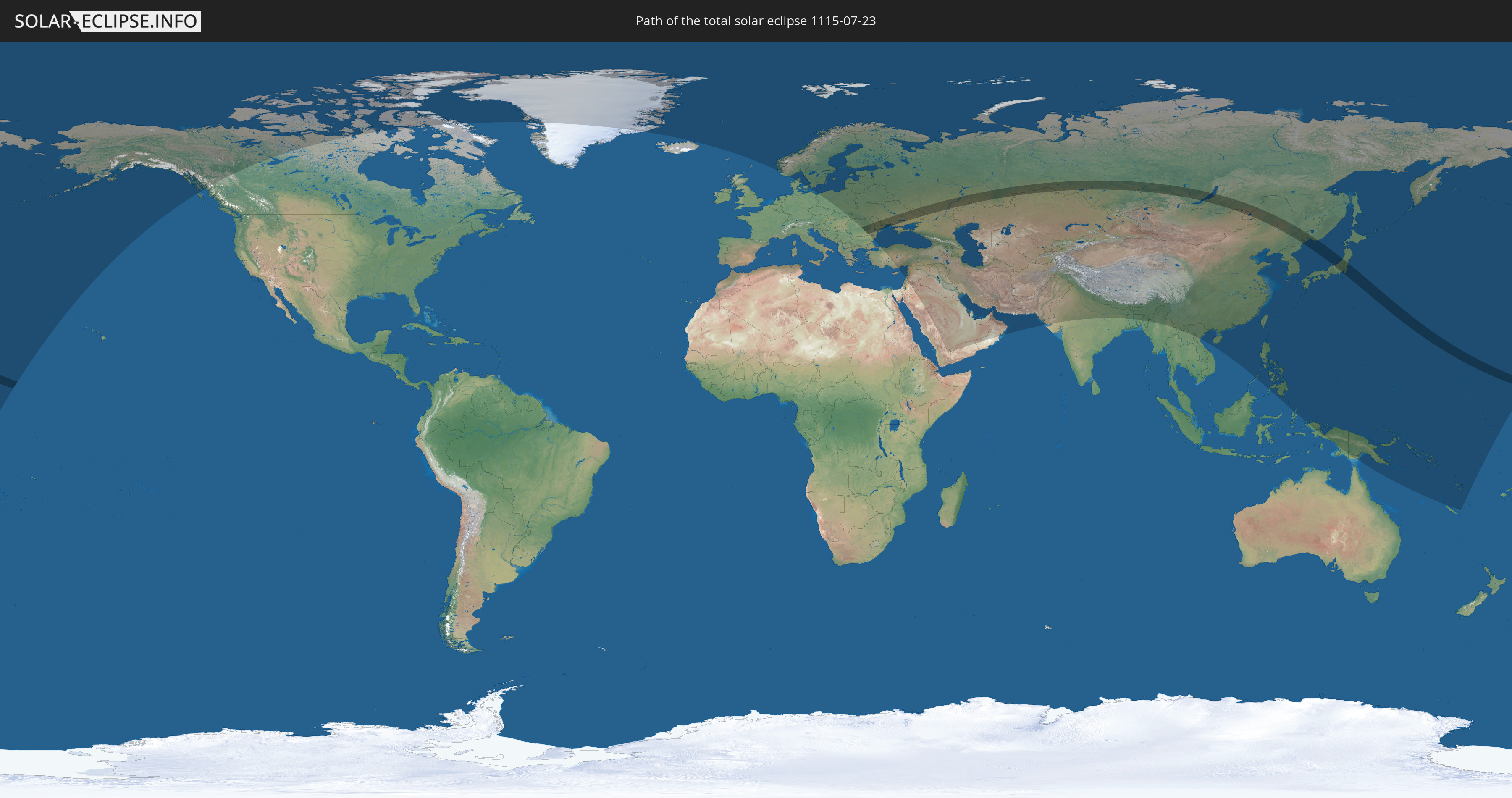
Total solar eclipse of 07/23/1115
| Day of week: | Friday |
| Maximum duration of eclipse: | 04m50s |
| Maximum width of eclipse path: | 246 km |
| Saros cycle: | 102 |
| Coverage: | 100% |
| Magnitude: | 1.0663 |
| Gamma: | 0.4783 |
Wo kann man die Sonnenfinsternis vom 07/23/1115 sehen?
Die Sonnenfinsternis am 07/23/1115 kann man in 75 Ländern als partielle Sonnenfinsternis beobachten.
Der Finsternispfad verläuft durch 10 Länder. Nur in diesen Ländern ist sie als total Sonnenfinsternis zu sehen.
In den folgenden Ländern ist die Sonnenfinsternis total zu sehen
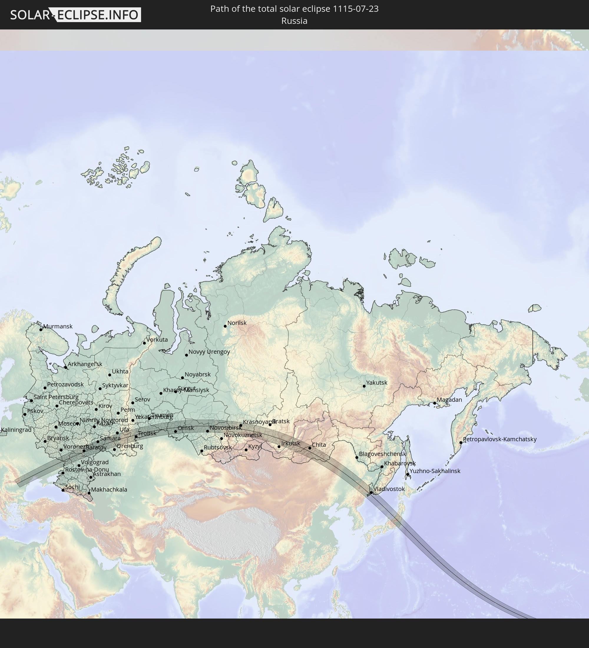 Russia
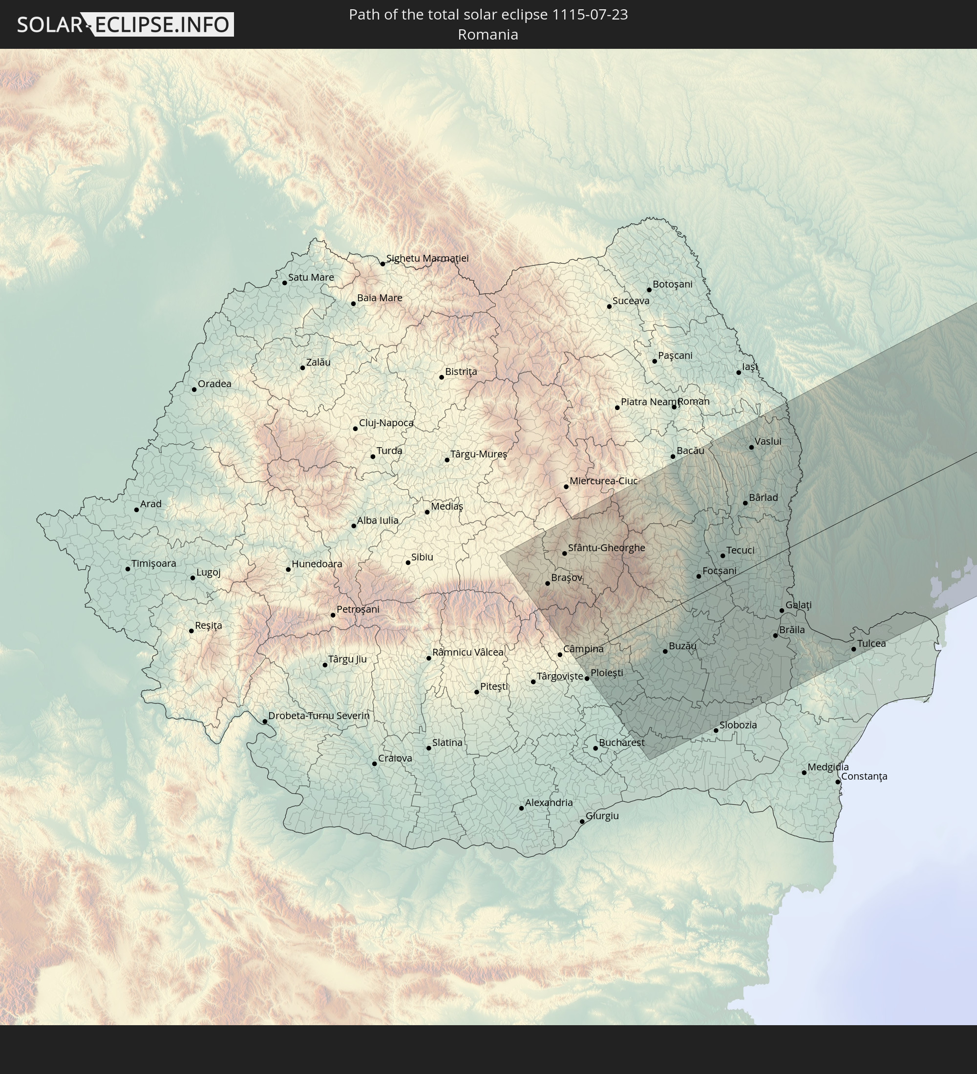 Romania
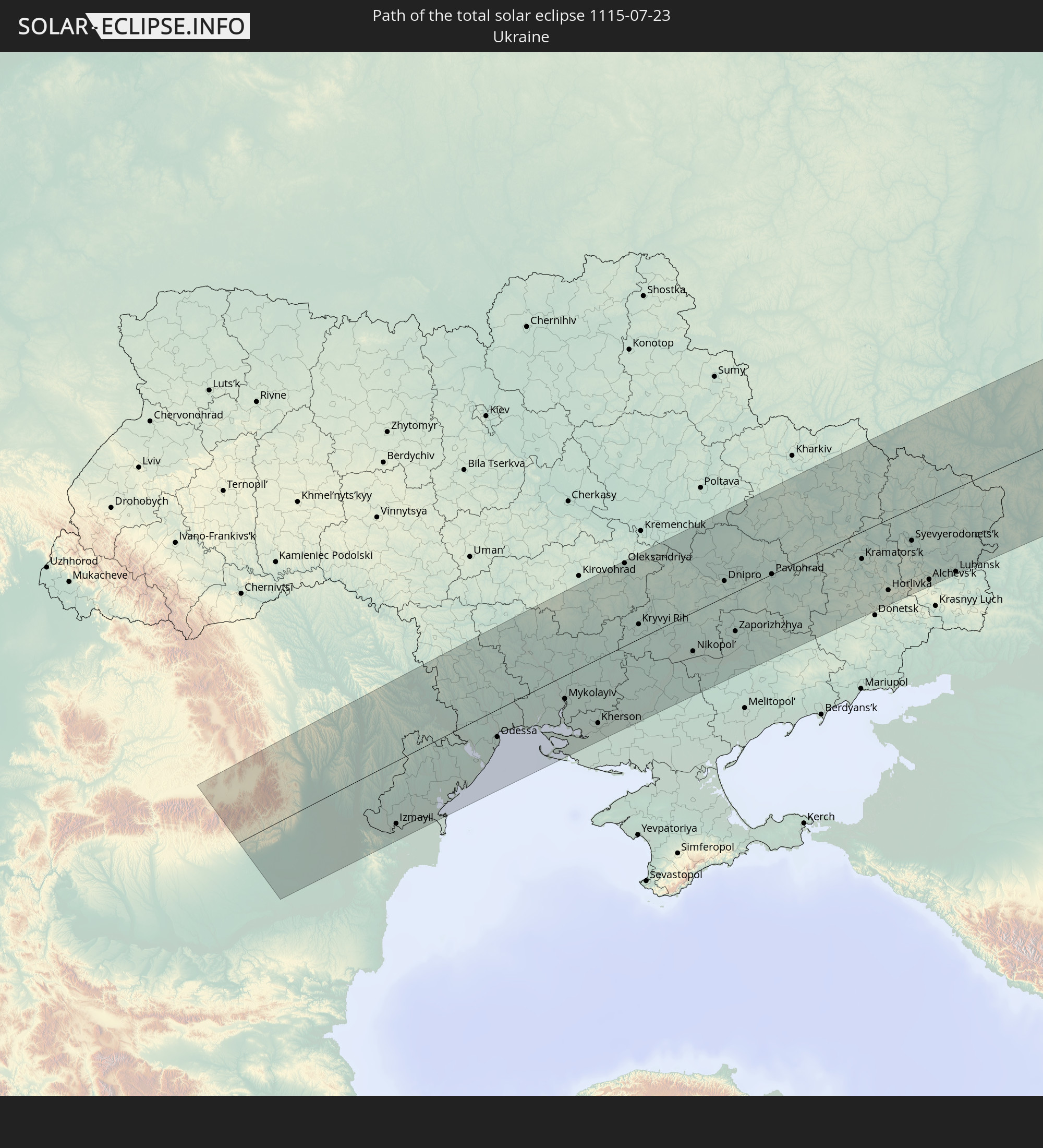 Ukraine
 Moldova
 Kazakhstan
 China
China
 Mongolia
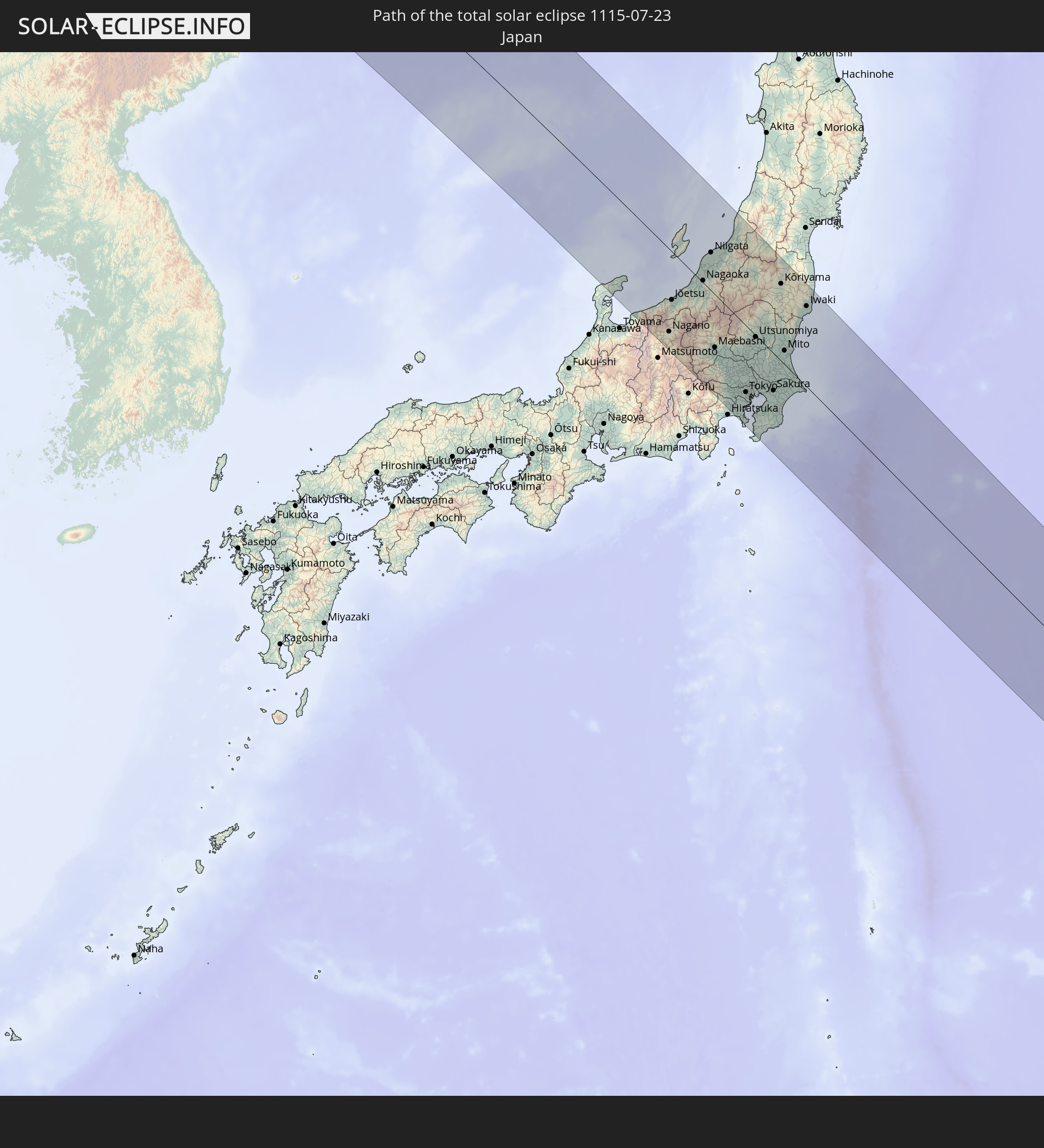 Japan
Japan
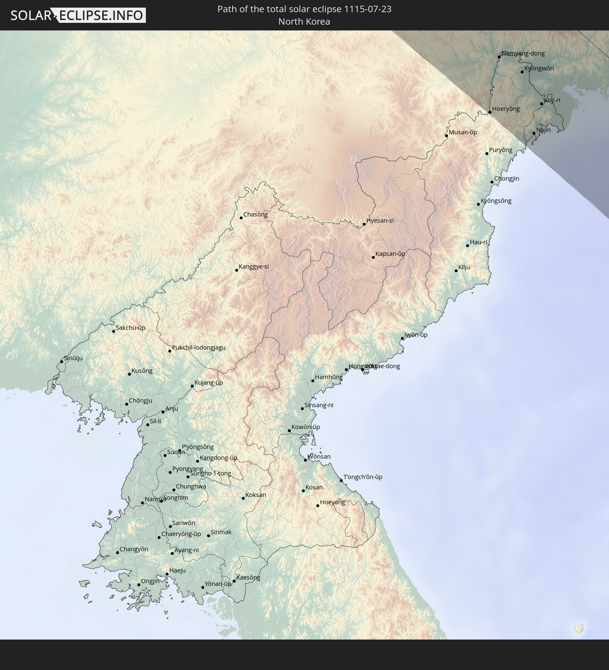 North Korea
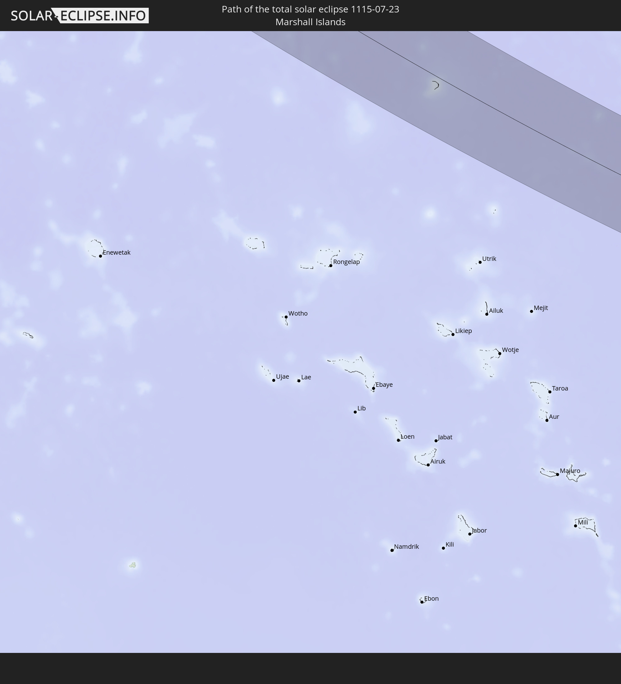 Marshall Islands
In den folgenden Ländern ist die Sonnenfinsternis partiell zu sehen
 Russia
 United States
 United States Minor Outlying Islands
 Kiribati
 Canada
 Greenland
 Iceland
 Svalbard and Jan Mayen
 Norway
 Denmark
 Sweden
 Poland
 Hungary
 Slovakia
 Åland Islands
 Romania
 Finland
 Lithuania
 Latvia
 Estonia
 Ukraine
 Bulgaria
 Belarus
 Turkey
 Moldova
 Saudi Arabia
 Jordan
 Lebanon
 Syria
Syria
 Iraq
Iraq
 Georgia
 Yemen
Yemen
 Armenia
 Iran
Iran
 Azerbaijan
 Kazakhstan
 Kuwait
 Bahrain
 Qatar
Qatar
 United Arab Emirates
 Oman
Oman
 Turkmenistan
 Uzbekistan
 Afghanistan
 Pakistan
 Tajikistan
 India
India
 Kyrgyzstan
 China
China
 Nepal
Nepal
 Mongolia
 Bangladesh
 Bhutan
 Myanmar
 Indonesia
 Laos
Laos
 Vietnam
 Australia
 Macau
Macau
 Hong Kong
 Taiwan
 Philippines
 Japan
Japan
 North Korea
 South Korea
 Palau
Palau
 Federated States of Micronesia
 Papua New Guinea
 Guam
Guam
 Northern Mariana Islands
 Solomon Islands
 New Caledonia
 Marshall Islands
 Vanuatu
 Nauru
Nauru
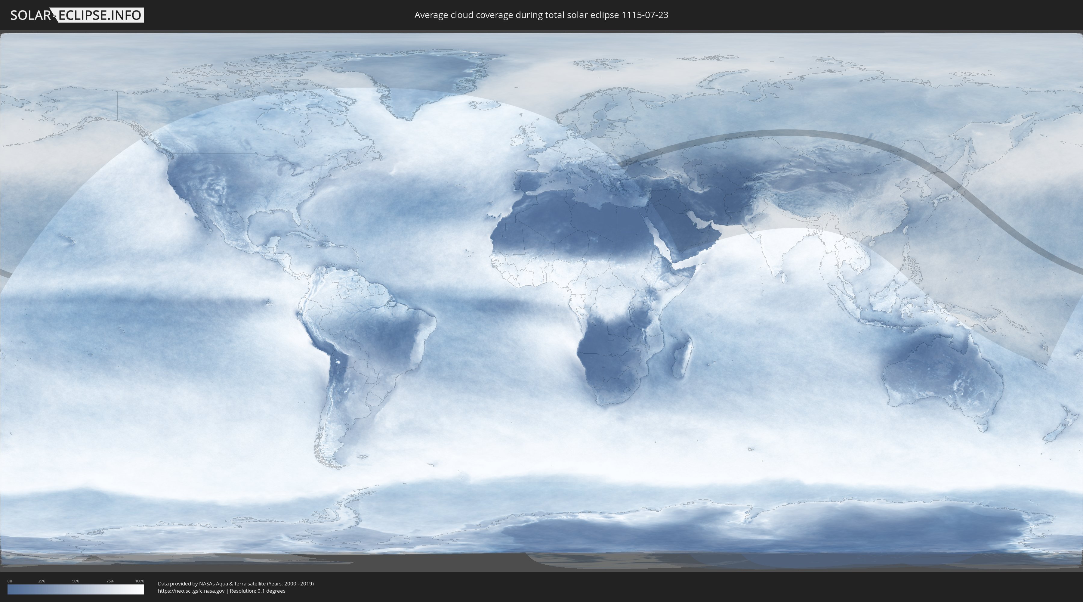
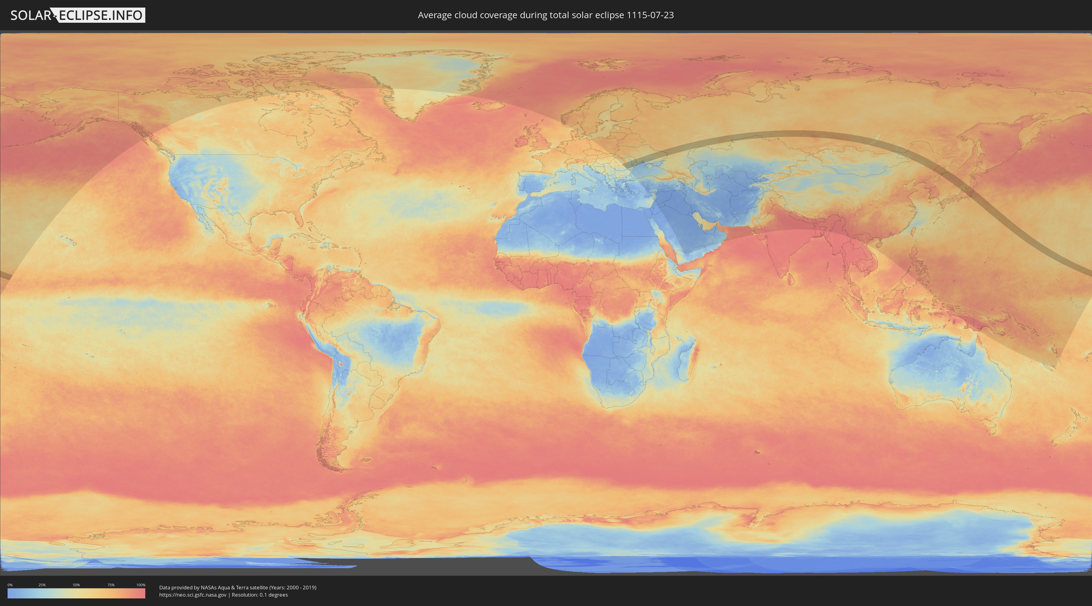
How will be the weather during the total solar eclipse on 07/23/1115?
Where is the best place to see the total solar eclipse of 07/23/1115?
The following maps show the average cloud coverage for the day of the total solar eclipse.
With the help of these maps, it is possible to find the place along the eclipse path, which has the best
chance of a cloudless sky.
Nevertheless, you should consider local circumstances and inform about the weather of your chosen
observation site.
The data is provided by NASAs satellites
AQUA and TERRA.
The cloud maps are averaged over a period of 19 years (2000 - 2019).
Detailed country maps
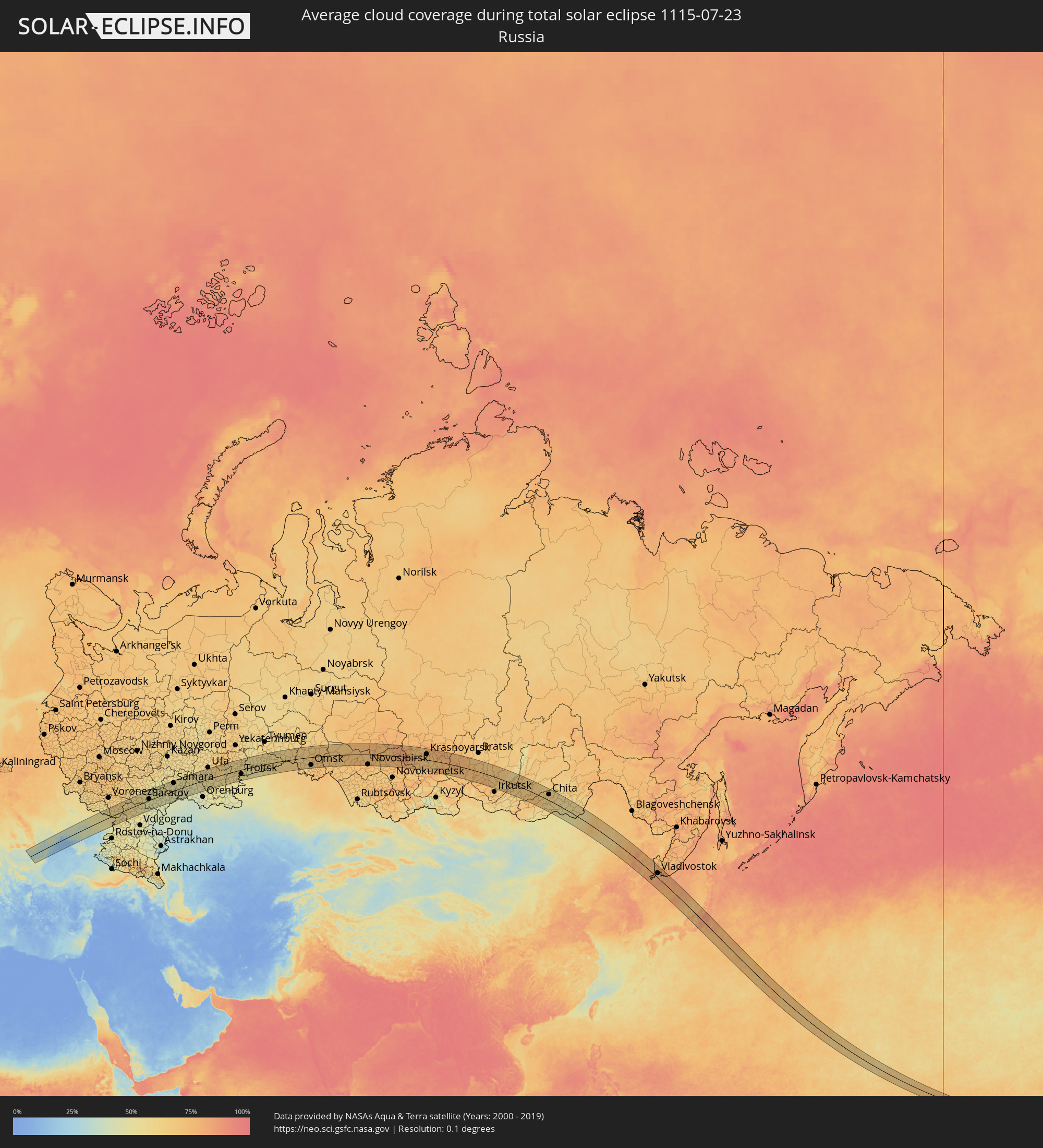 Russia
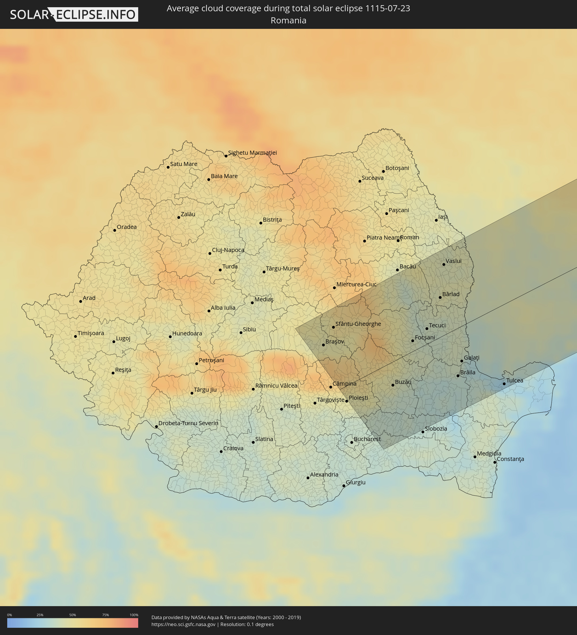 Romania
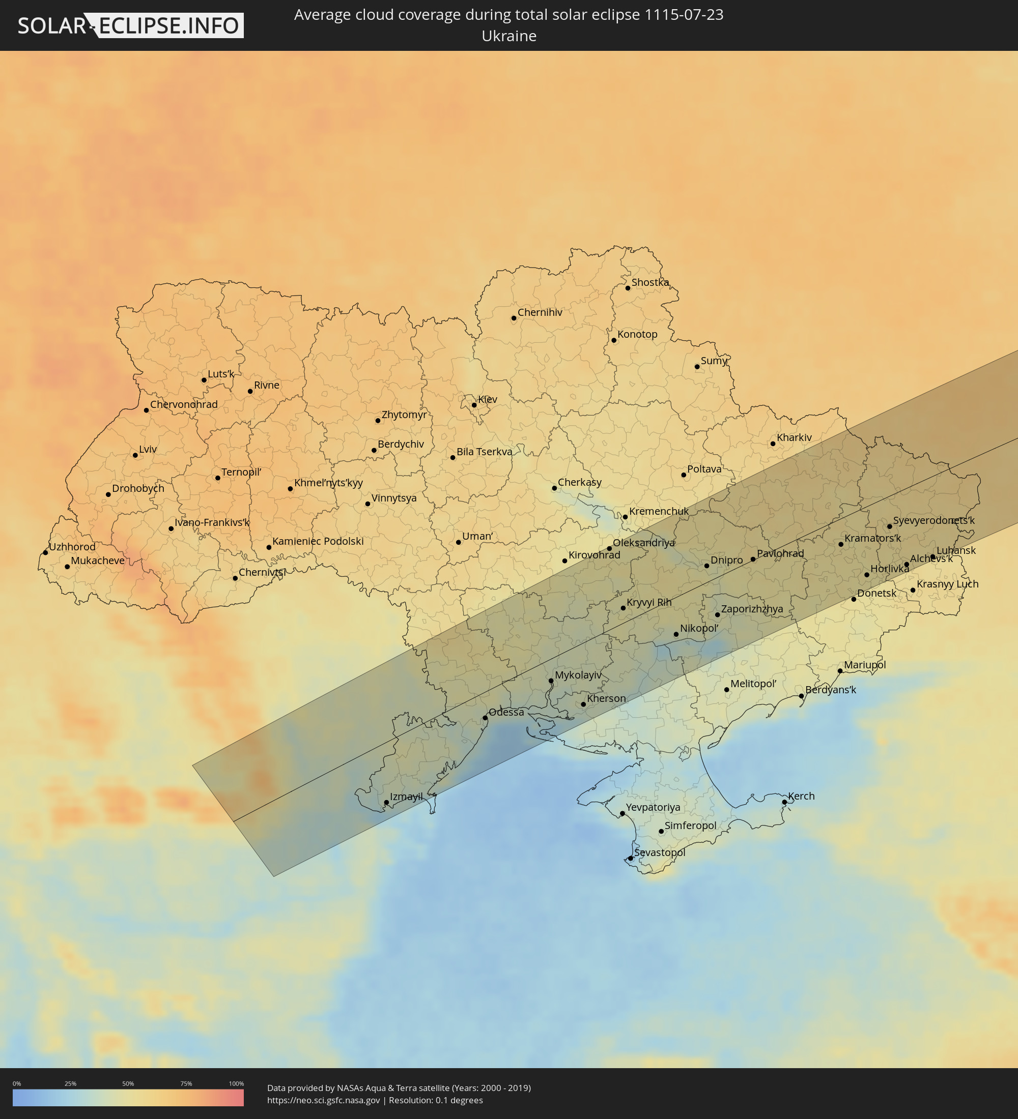 Ukraine
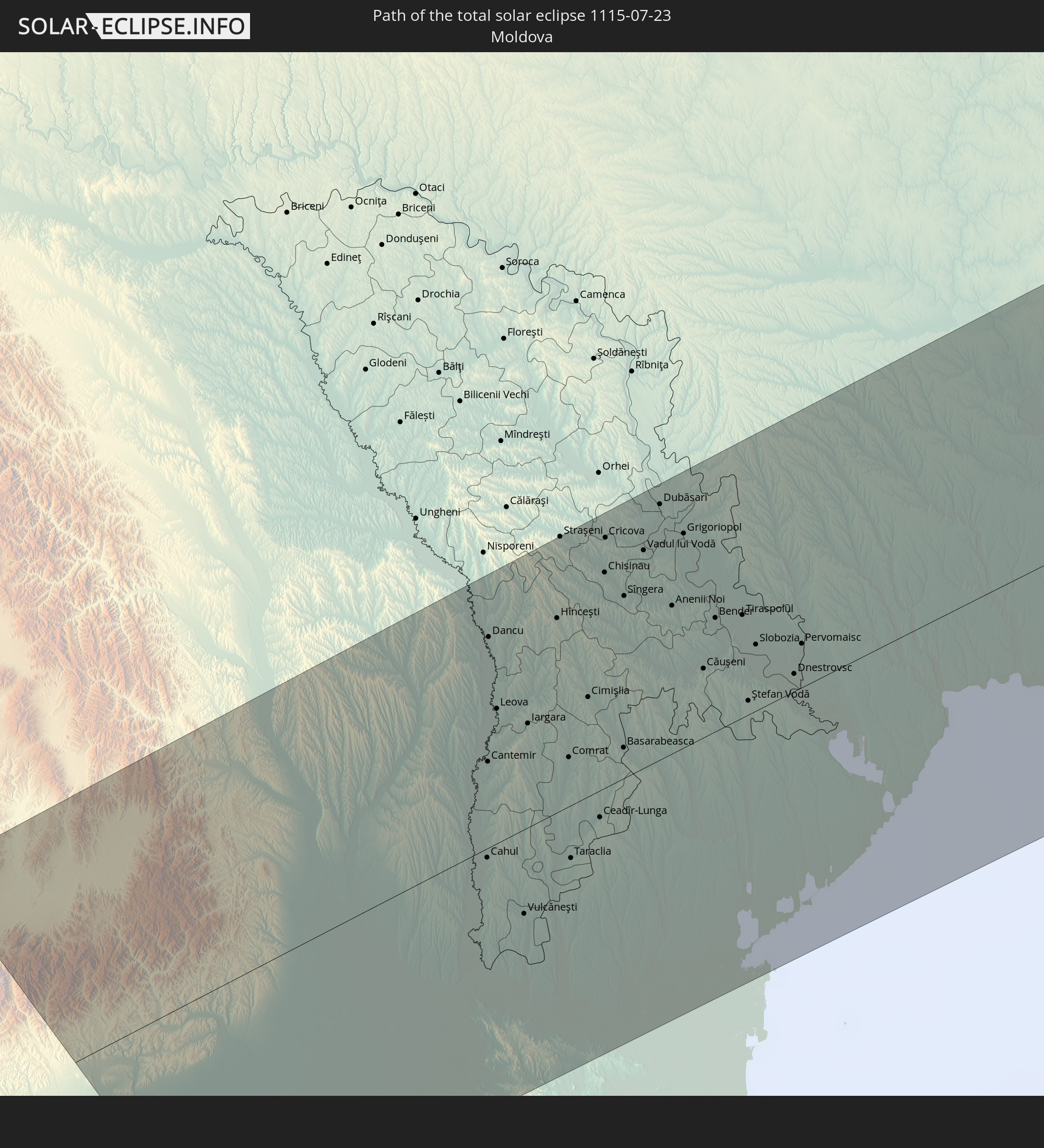
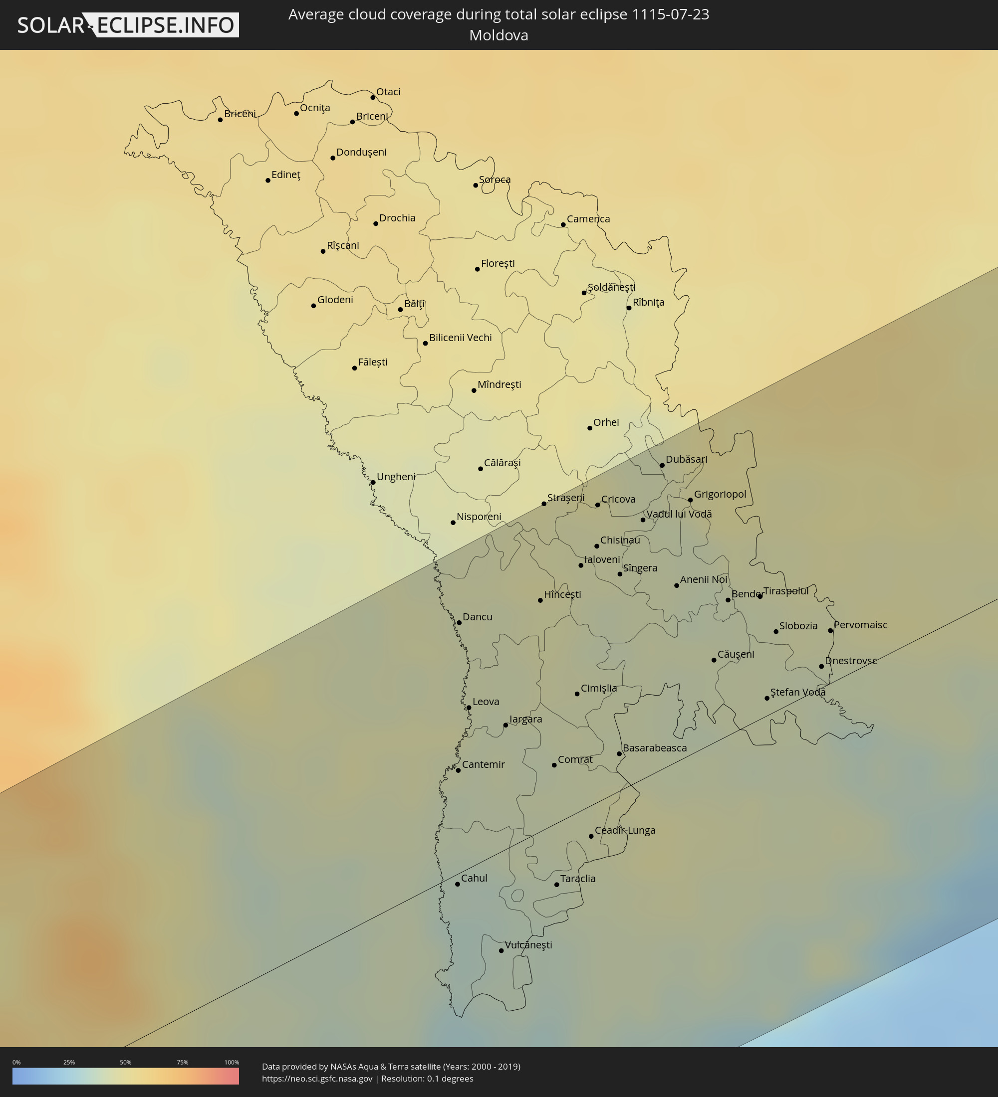 Moldova
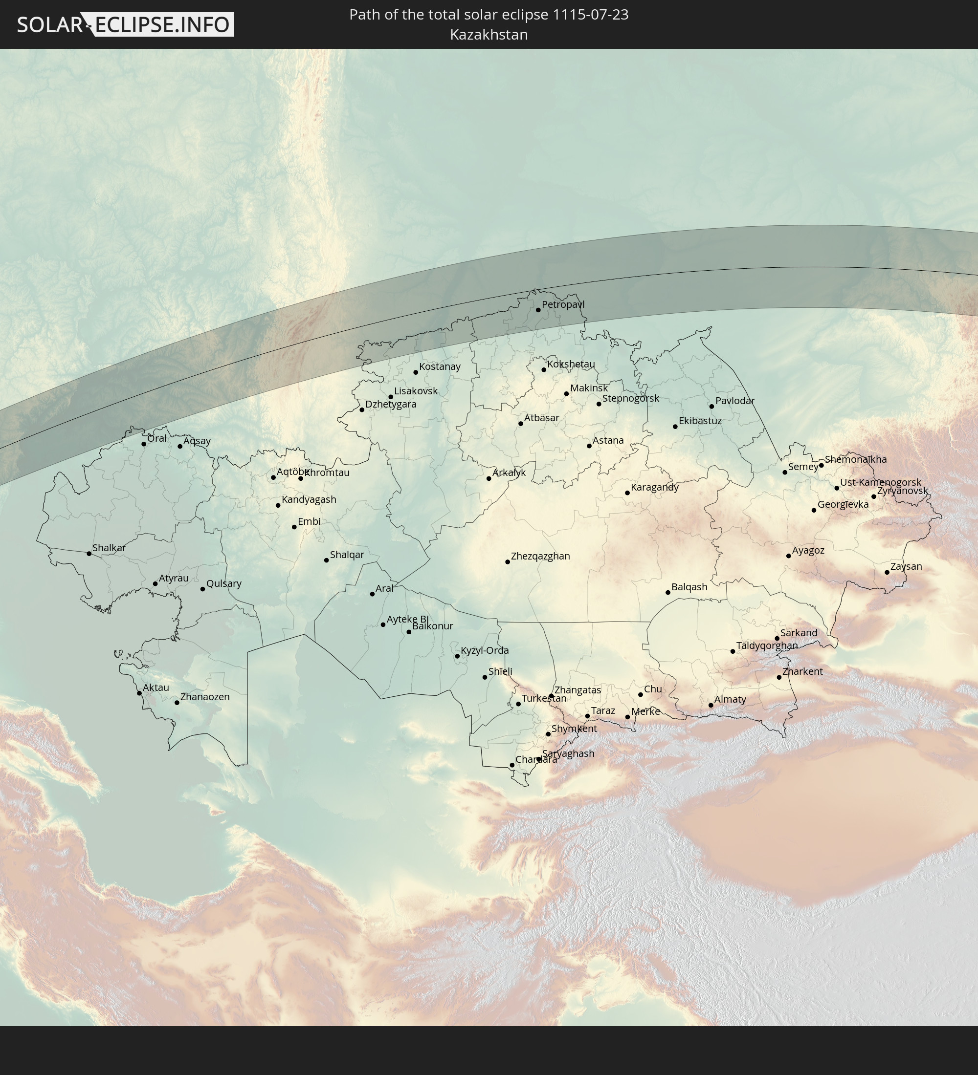
 Kazakhstan
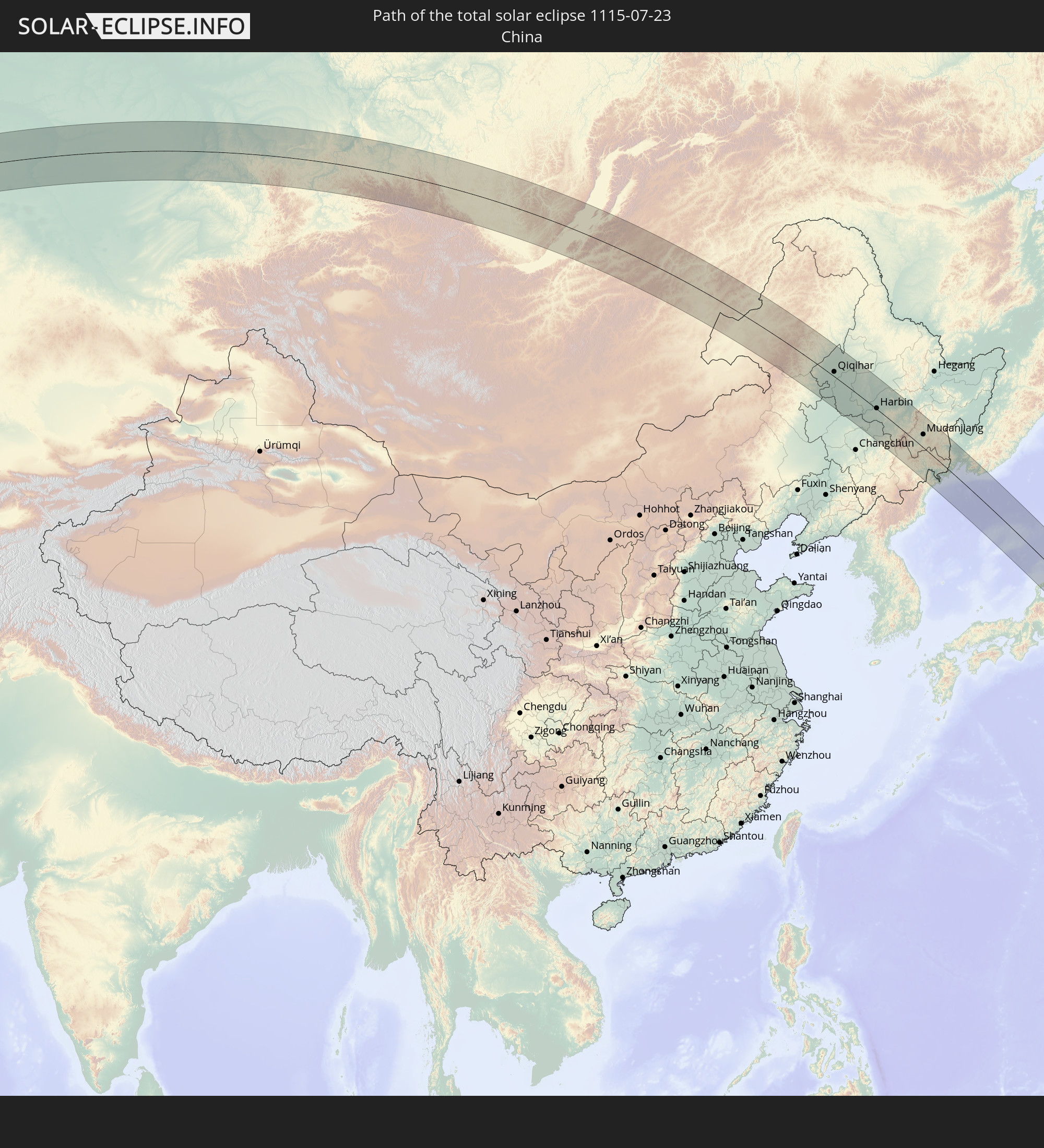
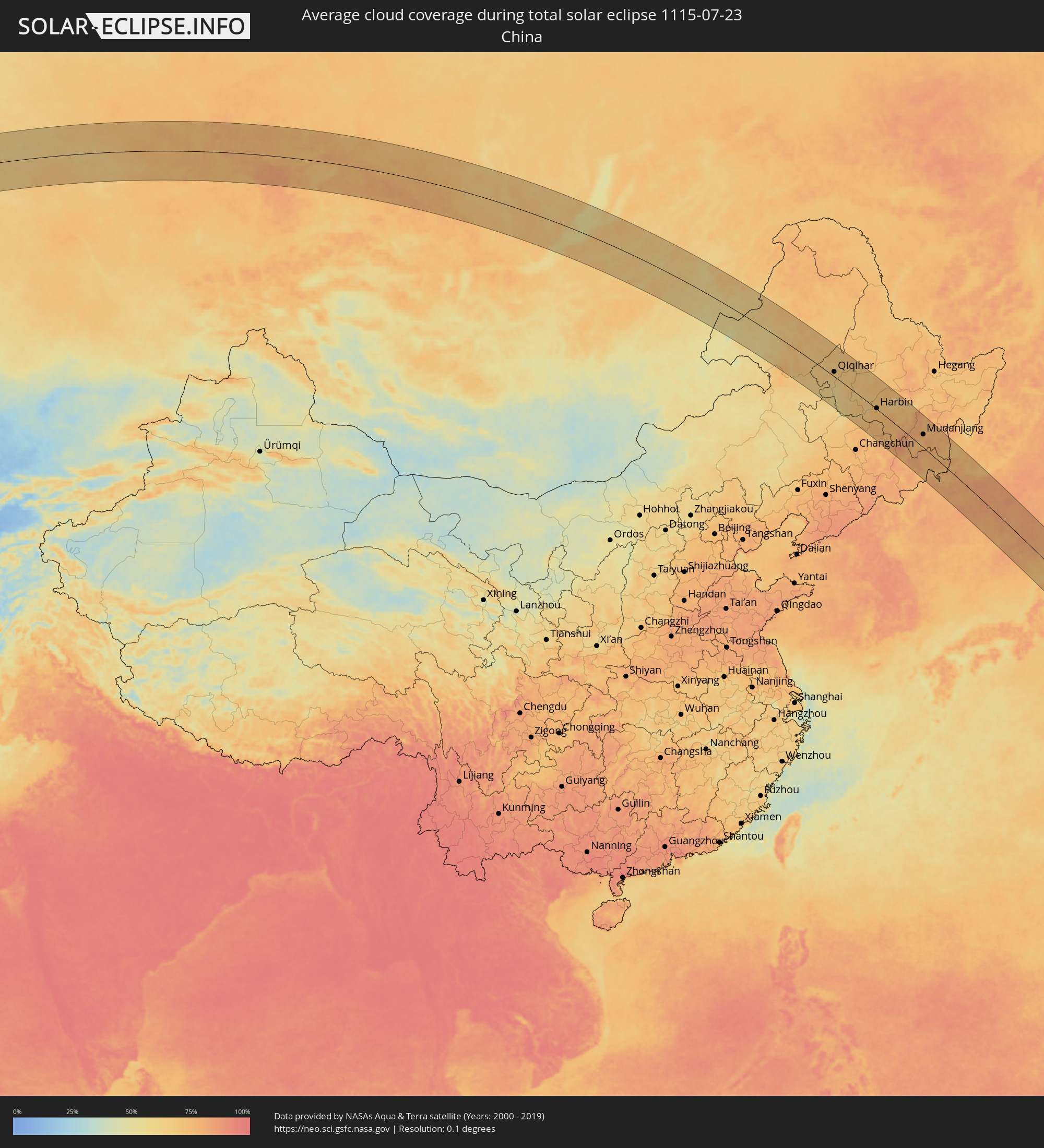 China
China
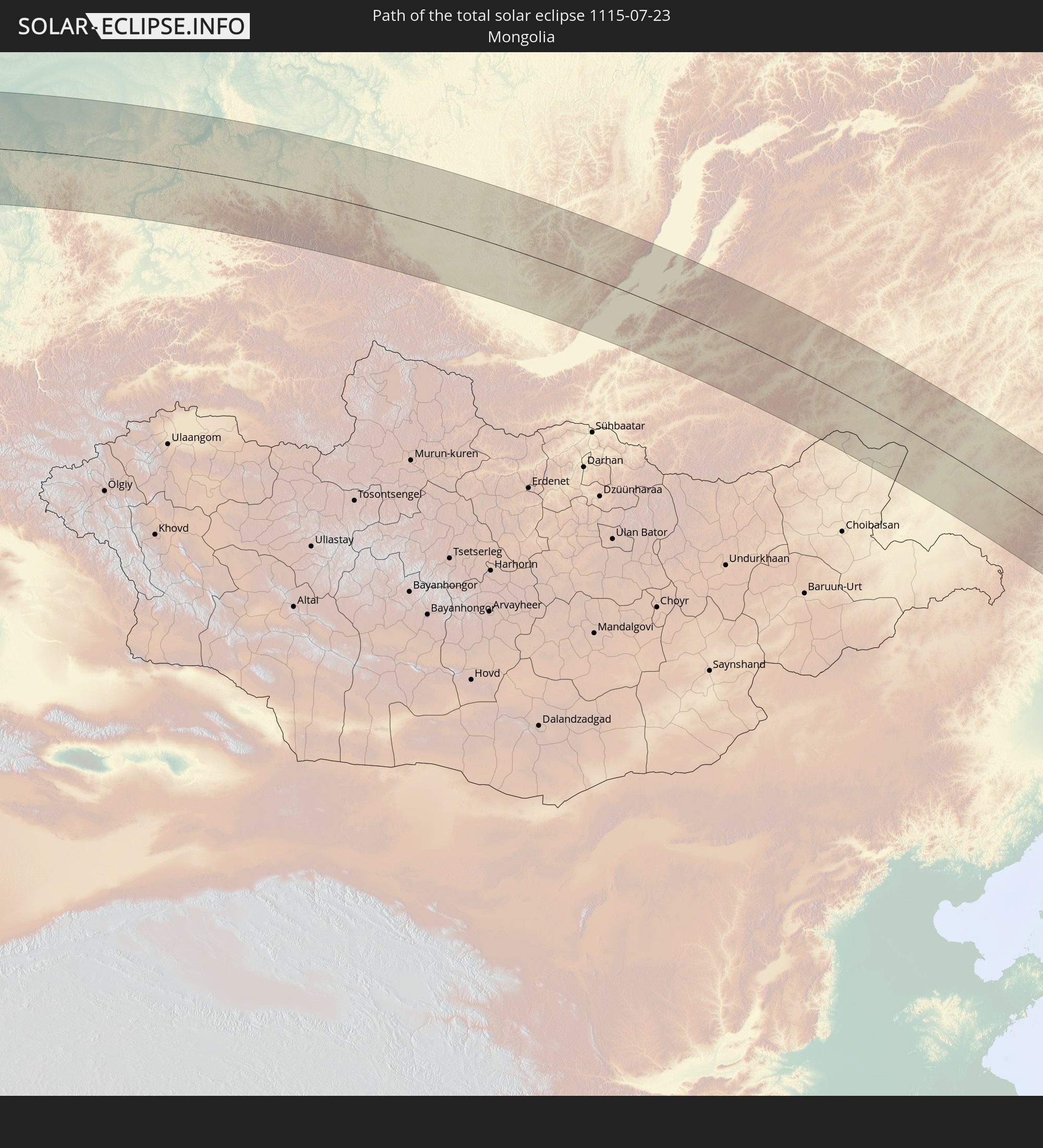
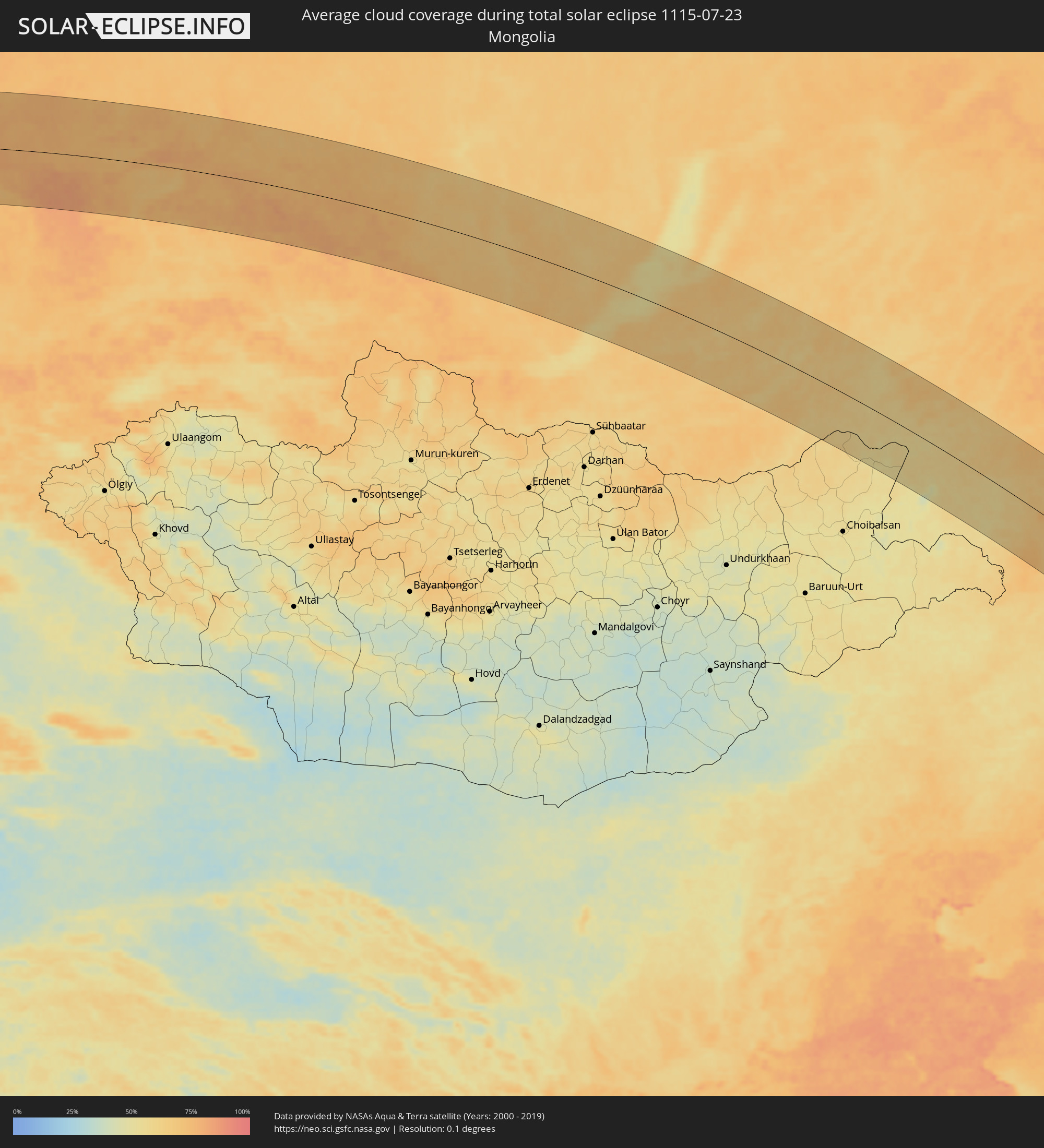 Mongolia
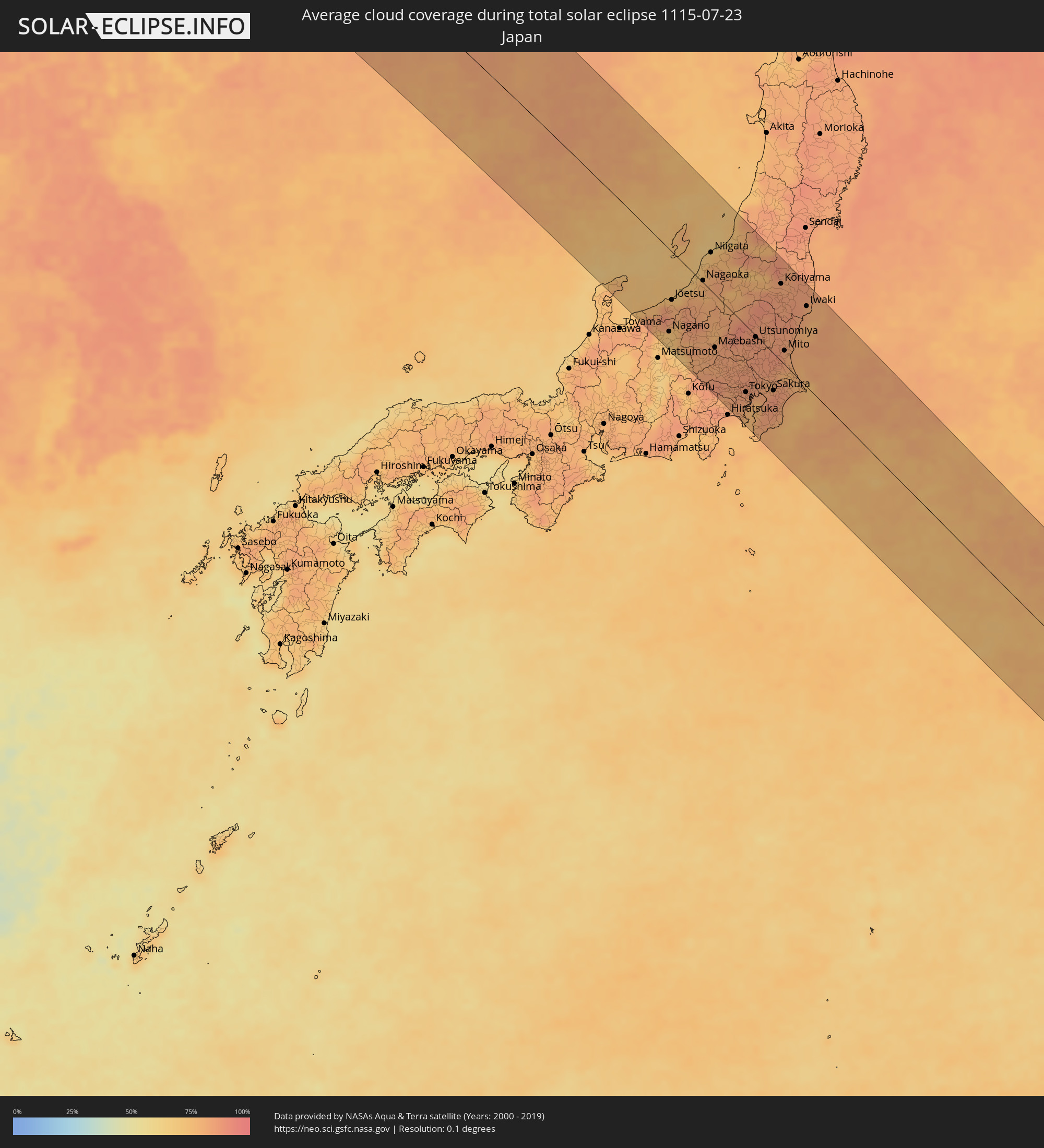 Japan
Japan
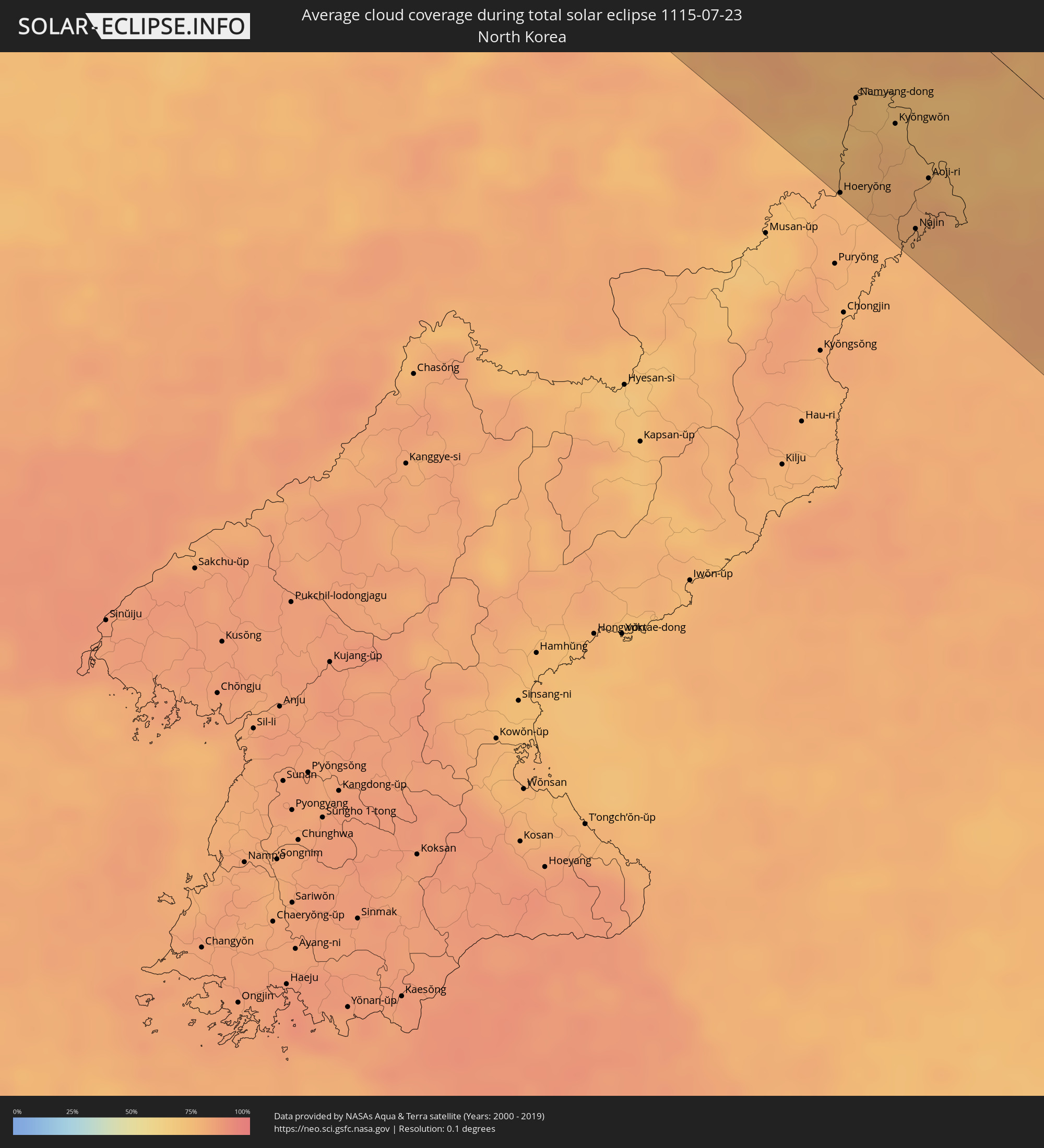 North Korea
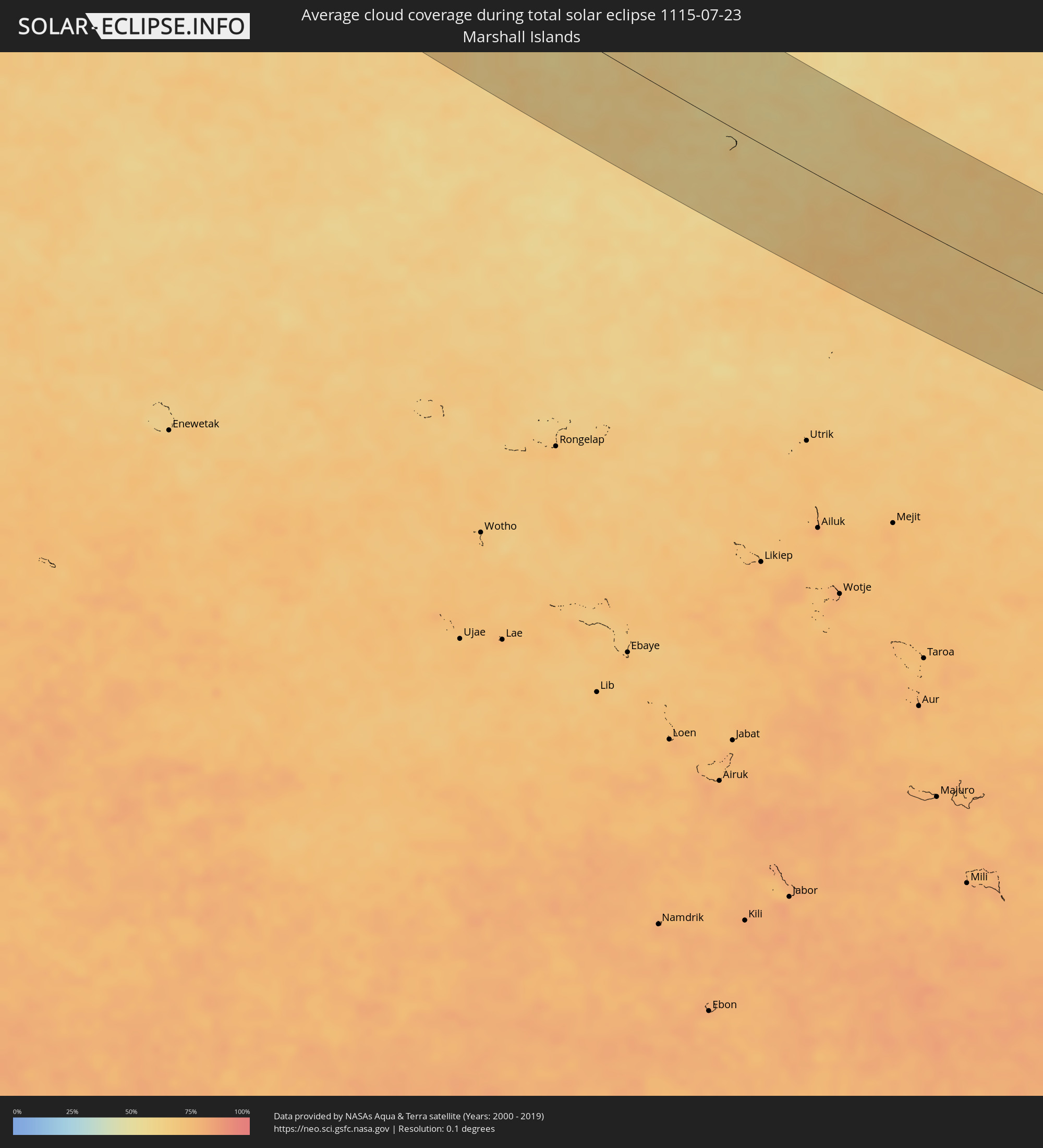 Marshall Islands
Cities inside the path of the eclipse
The following table shows all locations with a population of more than 5,000 inside the eclipse path. Cities which have more than 100,000 inhabitants are marked bold. A click at the locations opens a detailed map.
| City | Type | Eclipse duration | Local time of max. eclipse | Distance to central line | Ø Cloud coverage |
|
Braşov, Braşov
|
total | - | 04:45:04 UTC+01:44 | 64 km | 62% |
|
Sfântu-Gheorghe, Covasna
|
total | - | 04:45:12 UTC+01:44 | 79 km | 52% |
|
Vălenii de Munte, Prahova
|
total | - | 04:44:32 UTC+01:44 | 5 km | 52% |
|
Boldeşti-Scăeni, Prahova
|
total | - | 04:44:24 UTC+01:44 | 12 km | 45% |
|
Târgu Secuiesc, Covasna
|
total | - | 04:45:13 UTC+01:44 | 80 km | 54% |
|
Covasna, Covasna
|
total | - | 04:45:04 UTC+01:44 | 63 km | 56% |
|
Urlaţi, Prahova
|
total | - | 04:44:17 UTC+01:44 | 25 km | 43% |
|
Nehoiu, Buzău
|
total | - | 04:44:39 UTC+01:44 | 16 km | 57% |
|
Mizil, Prahova
|
total | - | 04:44:15 UTC+01:44 | 29 km | 39% |
|
Dărmăneşti, Bacău
|
total | - | 04:45:26 UTC+01:44 | 103 km | 55% |
|
Urziceni, Ialomiţa
|
total | - | 04:43:56 UTC+01:44 | 65 km | 36% |
|
Buzău, Buzău
|
total | - | 04:44:15 UTC+01:44 | 29 km | 44% |
|
Râmnicu Sărat, Buzău
|
total | - | 04:44:23 UTC+01:44 | 14 km | 39% |
|
Adjud, Vrancea
|
total | - | 04:45:00 UTC+01:44 | 53 km | 36% |
|
Focșani, Vrancea
|
total | - | 04:44:38 UTC+01:44 | 12 km | 40% |
|
Tecuci, Galaţi
|
total | - | 04:44:42 UTC+01:44 | 18 km | 38% |
|
Ianca, Brăila
|
total | - | 04:44:03 UTC+01:44 | 53 km | 31% |
|
Lieşti, Galaţi
|
total | - | 04:44:28 UTC+01:44 | 8 km | 39% |
|
Bârlad, Vaslui
|
total | - | 04:44:58 UTC+01:44 | 48 km | 43% |
|
Vaslui, Vaslui
|
total | - | 04:45:19 UTC+01:44 | 85 km | 44% |
|
Pechea, Galaţi
|
total | - | 04:44:24 UTC+01:44 | 16 km | 40% |
|
Brăila, Brăila
|
total | - | 04:44:01 UTC+01:44 | 59 km | 33% |
|
Galaţi, Galaţi
|
total | - | 04:44:10 UTC+01:44 | 43 km | 31% |
|
Huşi, Vaslui
|
total | - | 04:45:16 UTC+01:44 | 77 km | 43% |
|
Cahul, Cahul
|
total | - | 04:55:08 UTC+01:55 | 4 km | 33% |
|
Dancu, Hînceşti
|
total | - | 04:55:54 UTC+01:55 | 81 km | 43% |
|
Leova, Leova
|
total | - | 04:55:38 UTC+01:55 | 52 km | 41% |
|
Vulcăneşti, Găgăuzia
|
total | - | 04:54:52 UTC+01:55 | 33 km | 37% |
|
Hînceşti, Hînceşti
|
total | - | 04:55:52 UTC+01:55 | 74 km | 45% |
|
Straşeni, Strășeni
|
total | - | 04:56:10 UTC+01:55 | 104 km | 45% |
|
Comrat, Găgăuzia
|
total | - | 04:55:22 UTC+01:55 | 19 km | 42% |
|
Taraclia, Taraclia
|
total | - | 04:55:00 UTC+01:55 | 20 km | 39% |
|
Cimişlia, Cimişlia
|
total | - | 04:55:33 UTC+01:55 | 38 km | 43% |
|
Ialoveni, Laloveni
|
total | - | 04:55:56 UTC+01:55 | 79 km | 43% |
|
Tulcea, Tulcea
|
total | - | 04:43:42 UTC+01:44 | 98 km | 28% |
|
Ceadîr-Lunga, Găgăuzia
|
total | - | 04:55:06 UTC+01:55 | 10 km | 42% |
|
Izmayil, Odessa
|
total | - | 05:01:31 UTC+02:02 | 81 km | 25% |
|
Chisinau, Chişinău
|
total | - | 04:55:58 UTC+01:55 | 82 km | 44% |
|
Cricova, Chişinău
|
total | - | 04:56:06 UTC+01:55 | 95 km | 44% |
|
Basarabeasca, Basarabeasca
|
total | - | 04:55:19 UTC+01:55 | 12 km | 46% |
|
Sîngera, Chişinău
|
total | - | 04:55:51 UTC+01:55 | 69 km | 42% |
|
Dubăsari, Teleneşti
|
total | - | 04:56:08 UTC+01:55 | 97 km | 43% |
|
Anenii Noi, Anenii Noi
|
total | - | 04:55:45 UTC+01:55 | 56 km | 41% |
|
Grigoriopol, Teleneşti
|
total | - | 04:56:00 UTC+01:55 | 81 km | 43% |
|
Căuşeni, Căuşeni
|
total | - | 04:55:29 UTC+01:55 | 26 km | 42% |
|
Chiţcani, Căuşeni
|
total | - | 04:55:34 UTC+01:55 | 34 km | 42% |
|
Tiraspolul, Stînga Nistrului
|
total | - | 04:55:38 UTC+01:55 | 39 km | 42% |
|
Ştefan Vodă, Ştefan-Vodă
|
total | - | 04:55:19 UTC+01:55 | 5 km | 42% |
|
Slobozia, Stînga Nistrului
|
total | - | 04:55:30 UTC+01:55 | 25 km | 41% |
|
Dnestrovsc, Teleneşti
|
total | - | 04:55:21 UTC+01:55 | 7 km | 39% |
|
Pervomaisc, Stînga Nistrului
|
total | - | 04:55:27 UTC+01:55 | 17 km | 41% |
|
Odessa, Odessa
|
total | - | 05:02:06 UTC+02:02 | 35 km | 37% |
|
Mykolayiv, Mykolaiv
|
total | - | 05:02:18 UTC+02:02 | 30 km | 40% |
|
Kherson, Kherson
|
total | - | 05:01:53 UTC+02:02 | 82 km | 36% |
|
Oleksandriya, Kirovohrad
|
total | - | 05:03:46 UTC+02:02 | 103 km | 50% |
|
Kryvyi Rih, Dnipropetrovsk
|
total | - | 05:02:58 UTC+02:02 | 18 km | 48% |
|
Nikopol’, Dnipropetrovsk
|
total | - | 05:02:29 UTC+02:02 | 49 km | 35% |
|
Dniprodzerzhyns’k, Dnipropetrovsk
|
total | - | 05:03:24 UTC+02:02 | 38 km | 51% |
|
Energodar, Zaporizhia
|
total | - | 05:02:22 UTC+02:02 | 65 km | 38% |
|
Dnipro, Dnipropetrovsk
|
total | - | 05:03:17 UTC+02:02 | 20 km | 48% |
|
Zaporizhzhya, Zaporizhia
|
total | - | 05:02:37 UTC+02:02 | 50 km | 44% |
|
Novomoskovs’k, Dnipropetrovsk
|
total | - | 05:03:26 UTC+02:02 | 30 km | 47% |
|
Pavlohrad, Dnipropetrovsk
|
total | - | 05:03:16 UTC+02:02 | 0 km | 50% |
|
Lozova, Kharkiv
|
total | - | 05:03:35 UTC+02:02 | 22 km | 52% |
|
Krasnoarmiys’k, Donetsk
|
total | - | 05:02:53 UTC+02:02 | 67 km | 51% |
|
Kramators’k, Donetsk
|
total | - | 05:03:18 UTC+02:02 | 34 km | 53% |
|
Sloviansk, Donetsk
|
total | - | 05:03:27 UTC+02:02 | 21 km | 52% |
|
Kostyantynivka, Donetsk
|
total | - | 05:03:05 UTC+02:02 | 58 km | 52% |
|
Artemivs’k, Donetsk
|
total | - | 05:03:08 UTC+02:02 | 61 km | 50% |
|
Horlivka, Donetsk
|
total | - | 05:02:52 UTC+02:02 | 88 km | 50% |
|
Yenakiyeve, Donetsk
|
total | - | 05:02:45 UTC+02:02 | 104 km | 49% |
|
Syevyerodonets’k, Luhansk
|
total | - | 05:03:29 UTC+02:02 | 40 km | 54% |
|
Stakhanov, Luhansk
|
total | - | 05:03:04 UTC+02:02 | 83 km | 52% |
|
Alchevs’k, Luhansk
|
total | - | 05:02:58 UTC+02:02 | 98 km | 53% |
|
Luhansk, Luhansk
|
total | - | 05:03:02 UTC+02:02 | 104 km | 53% |
|
Balashov, Saratov
|
total | - | 06:24:35 UTC+03:20 | 89 km | 60% |
|
Saratov, Saratov
|
total | - | 06:24:48 UTC+03:20 | 12 km | 49% |
|
Balakovo, Saratov
|
total | - | 06:25:36 UTC+03:20 | 17 km | 48% |
|
Novokuybyshevsk, Samara
|
total | - | 06:27:13 UTC+03:20 | 76 km | 54% |
|
Samara, Samara
|
total | - | 06:27:23 UTC+03:20 | 82 km | 56% |
|
Salavat, Bashkortostan
|
total | - | 07:11:22 UTC+04:02 | 22 km | 61% |
|
Sterlitamak, Bashkortostan
|
total | - | 07:11:40 UTC+04:02 | 3 km | 61% |
|
Magnitogorsk, Chelyabinsk
|
total | - | 07:12:35 UTC+04:02 | 77 km | 61% |
|
Zlatoust, Chelyabinsk
|
total | - | 07:14:50 UTC+04:02 | 101 km | 68% |
|
Miass, Chelyabinsk
|
total | - | 07:14:53 UTC+04:02 | 80 km | 69% |
|
Chelyabinsk, Chelyabinsk
|
total | - | 07:15:35 UTC+04:02 | 71 km | 66% |
|
Komsomolets, Qostanay
|
total | - | 07:33:37 UTC+04:21 | 91 km | 55% |
|
Kurgan, Kurgan
|
total | - | 07:17:51 UTC+04:02 | 47 km | 64% |
|
Bishkul, Soltüstik Qazaqstan
|
total | - | 07:38:39 UTC+04:21 | 70 km | 61% |
|
Petropavl, Soltüstik Qazaqstan
|
total | - | 07:38:47 UTC+04:21 | 60 km | 63% |
|
Smirnovo, Soltüstik Qazaqstan
|
total | - | 07:38:36 UTC+04:21 | 102 km | 65% |
|
Bulayevo, Soltüstik Qazaqstan
|
total | - | 07:39:40 UTC+04:21 | 68 km | 63% |
|
Omsk, Omsk
|
total | - | 08:13:25 UTC+04:53 | 82 km | 72% |
|
Novosibirsk, Novosibirsk
|
total | - | 09:39:26 UTC+06:11 | 105 km | 77% |
|
Tomsk, Tomsk
|
total | - | 09:42:19 UTC+06:11 | 62 km | 78% |
|
Kemerovo, Kemerovo
|
total | - | 09:42:40 UTC+06:11 | 64 km | 75% |
|
Achinsk, Krasnoyarskiy
|
total | - | 09:47:38 UTC+06:11 | 65 km | 75% |
|
Krasnoyarsk, Krasnoyarskiy
|
total | - | 09:50:02 UTC+06:11 | 59 km | 76% |
|
Zheleznogorsk, Krasnoyarskiy
|
total | - | 09:50:49 UTC+06:11 | 91 km | 72% |
|
Kansk, Krasnoyarskiy
|
total | - | 09:53:12 UTC+06:11 | 111 km | 69% |
|
Chita, Transbaikal Territory
|
total | - | 12:44:06 UTC+08:38 | 62 km | 62% |
|
Jalai Nur, Inner Mongolia
|
total | - | 12:13:13 UTC+08:00 | 44 km | 58% |
|
Hailar, Inner Mongolia
|
total | - | 12:16:19 UTC+08:00 | 9 km | 58% |
|
Yakeshi, Inner Mongolia
|
total | - | 12:17:41 UTC+08:00 | 58 km | 64% |
|
Zhalantun, Inner Mongolia
|
total | - | 12:22:00 UTC+08:00 | 25 km | 67% |
|
Longjiang, Heilongjiang
|
total | - | 12:23:29 UTC+08:00 | 17 km | 68% |
|
Hulan Ergi, Heilongjiang
|
total | - | 12:24:18 UTC+08:00 | 8 km | 66% |
|
Qiqihar, Heilongjiang
|
total | - | 12:24:35 UTC+08:00 | 19 km | 67% |
|
Fendou, Heilongjiang
|
total | - | 12:26:47 UTC+08:00 | 3 km | 71% |
|
Honggang, Heilongjiang
|
total | - | 12:27:08 UTC+08:00 | 23 km | 68% |
|
Longfeng, Heilongjiang
|
total | - | 12:27:16 UTC+08:00 | 1 km | 66% |
|
Anda, Heilongjiang
|
total | - | 12:27:45 UTC+08:00 | 3 km | 65% |
|
Zhaodong, Heilongjiang
|
total | - | 12:29:09 UTC+08:00 | 1 km | 69% |
|
Shuangcheng, Heilongjiang
|
total | - | 12:30:36 UTC+08:00 | 49 km | 72% |
|
Yushu, Jilin
|
total | - | 12:31:46 UTC+08:00 | 85 km | 77% |
|
Hulan, Heilongjiang
|
total | - | 12:30:09 UTC+08:00 | 21 km | 72% |
|
Harbin, Heilongjiang
|
total | - | 12:30:33 UTC+08:00 | 3 km | 74% |
|
Jishu, Jilin
|
total | - | 12:32:52 UTC+08:00 | 114 km | 79% |
|
Acheng, Heilongjiang
|
total | - | 12:31:18 UTC+08:00 | 2 km | 73% |
|
Suihua, Heilongjiang
|
total | - | 12:29:45 UTC+08:00 | 97 km | 74% |
|
Wuchang, Heilongjiang
|
total | - | 12:32:28 UTC+08:00 | 45 km | 75% |
|
Dunhua, Jilin
|
total | - | 12:36:22 UTC+08:00 | 122 km | 78% |
|
Longjing, Jilin
|
total | - | 12:38:59 UTC+08:00 | 112 km | 73% |
|
Yanji, Jilin
|
total | - | 12:38:53 UTC+08:00 | 96 km | 74% |
|
Mudanjiang, Heilongjiang
|
total | - | 12:36:22 UTC+08:00 | 51 km | 75% |
|
Hoeryŏng, Hamgyŏng-bukto
|
total | - | 13:02:59 UTC+08:23 | 122 km | 77% |
|
Wangqing, Jilin
|
total | - | 12:38:35 UTC+08:00 | 47 km | 75% |
|
Namyang-dong, Hamgyŏng-bukto
|
total | - | 13:02:19 UTC+08:23 | 73 km | 74% |
|
Onsŏng, Hamgyŏng-bukto
|
total | - | 13:02:29 UTC+08:23 | 66 km | 73% |
|
Kyŏngwŏn, Hamgyŏng-bukto
|
total | - | 13:02:56 UTC+08:23 | 69 km | 75% |
|
Najin, Rason
|
total | - | 13:04:04 UTC+08:23 | 109 km | 78% |
|
Aoji-ri, Hamgyŏng-bukto
|
total | - | 13:03:45 UTC+08:23 | 81 km | 77% |
|
Sŏnbong, Rason
|
total | - | 13:04:02 UTC+08:23 | 96 km | 79% |
|
Ungsang-nodongjagu, Rason
|
total | - | 13:04:06 UTC+08:23 | 91 km | 80% |
|
Vladivostok, Primorskiy
|
total | - | 13:29:19 UTC+08:47 | 48 km | 78% |
|
Ussuriysk, Primorskiy
|
total | - | 13:28:16 UTC+08:47 | 110 km | 72% |
|
Artëm, Primorskiy
|
total | - | 13:29:19 UTC+08:47 | 86 km | 74% |
|
Nakhodka, Primorskiy
|
total | - | 13:31:07 UTC+08:47 | 79 km | 76% |
|
Nagano, Nagano
|
total | - | 14:01:11 UTC+09:00 | 102 km | 71% |
|
Jōetsu, Niigata
|
total | - | 14:00:20 UTC+09:00 | 59 km | 82% |
|
Nagaoka, Niigata
|
total | - | 14:00:31 UTC+09:00 | 3 km | 78% |
|
Niigata, Niigata
|
total | - | 13:59:54 UTC+09:00 | 47 km | 73% |
|
Maebashi, Gunma
|
total | - | 14:02:43 UTC+09:00 | 66 km | 81% |
|
Hachiōji, Tokyo
|
total | - | 14:04:23 UTC+09:00 | 109 km | 81% |
|
Machida, Tokyo
|
total | - | 14:04:44 UTC+09:00 | 110 km | 81% |
|
Tokorozawa, Saitama
|
total | - | 14:04:17 UTC+09:00 | 89 km | 82% |
|
Fujisawa, Kanagawa
|
total | - | 14:05:07 UTC+09:00 | 124 km | 75% |
|
Yokohama, Kanagawa
|
total | - | 14:05:10 UTC+09:00 | 106 km | 76% |
|
Saitama, Saitama
|
total | - | 14:04:18 UTC+09:00 | 68 km | 86% |
|
Yokosuka, Kanagawa
|
total | - | 14:05:28 UTC+09:00 | 117 km | 75% |
|
Tokyo, Tokyo
|
total | - | 14:04:44 UTC+09:00 | 83 km | 83% |
|
Sōka, Saitama
|
total | - | 14:04:35 UTC+09:00 | 65 km | 84% |
|
Oyama, Tochigi
|
total | - | 14:03:44 UTC+09:00 | 28 km | 86% |
|
Utsunomiya, Tochigi
|
total | - | 14:03:20 UTC+09:00 | 2 km | 86% |
|
Kashiwa, Chiba
|
total | - | 14:04:45 UTC+09:00 | 51 km | 82% |
|
Honchō, Chiba
|
total | - | 14:05:03 UTC+09:00 | 63 km | 81% |
|
Tsukuba, Ibaraki
|
total | - | 14:04:16 UTC+09:00 | 17 km | 86% |
|
Chiba, Chiba
|
total | - | 14:05:23 UTC+09:00 | 63 km | 85% |
|
Sakura, Chiba
|
total | - | 14:05:18 UTC+09:00 | 46 km | 88% |
|
Kōriyama, Fukushima
|
total | - | 14:02:22 UTC+09:00 | 95 km | 82% |
|
Mito, Ibaraki
|
total | - | 14:04:23 UTC+09:00 | 17 km | 81% |
|
Hitachi, Ibaraki
|
total | - | 14:04:09 UTC+09:00 | 50 km | 82% |
|
Iwaki, Fukushima
|
total | - | 14:03:34 UTC+09:00 | 99 km | 81% |