Total solar eclipse of 03/10/1122
| Day of week: | Friday |
| Maximum duration of eclipse: | 04m47s |
| Maximum width of eclipse path: | 235 km |
| Saros cycle: | 96 |
| Coverage: | 100% |
| Magnitude: | 1.0588 |
| Gamma: | 0.5736 |
Wo kann man die Sonnenfinsternis vom 03/10/1122 sehen?
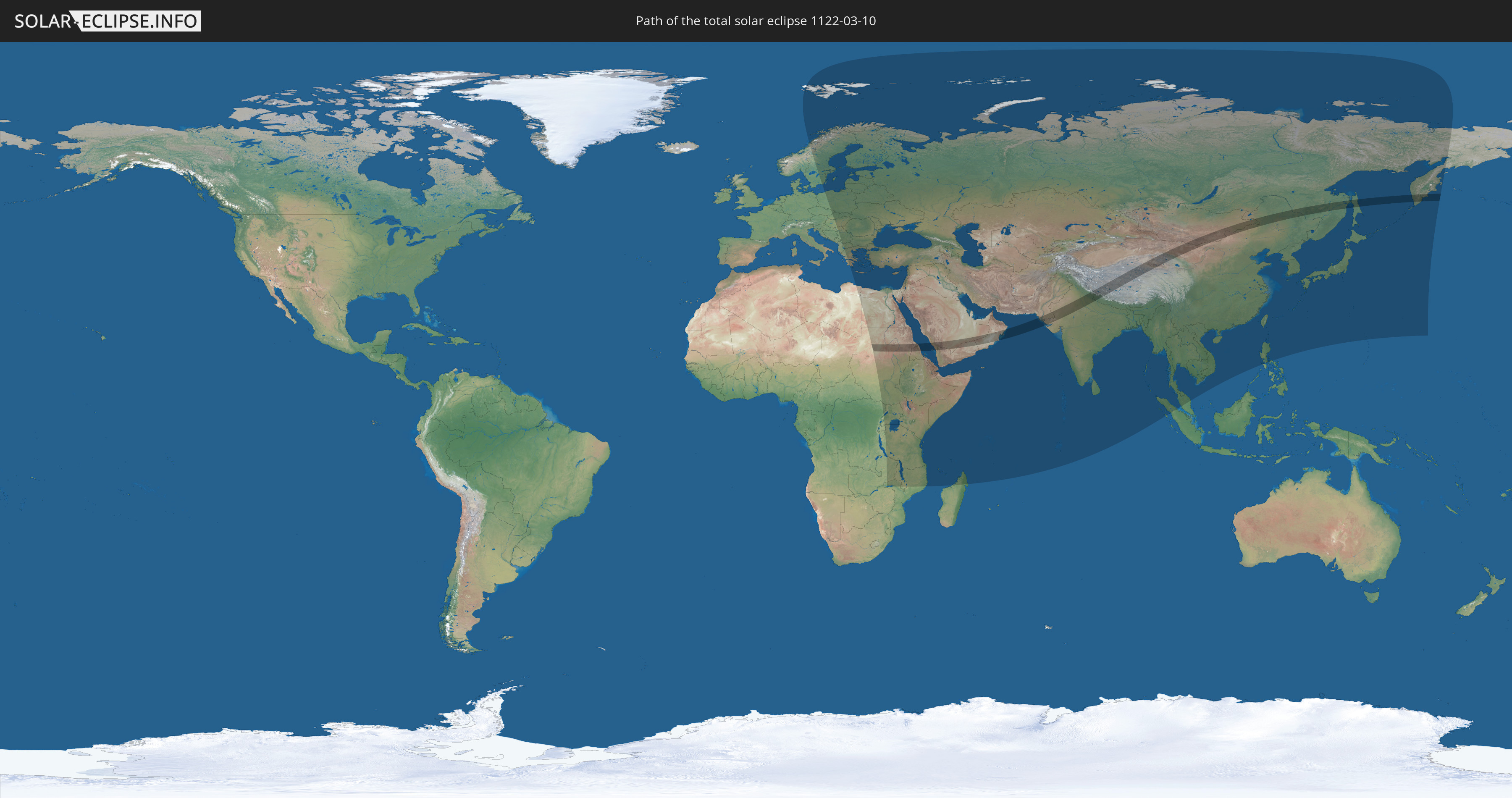
Die Sonnenfinsternis am 03/10/1122 kann man in 93 Ländern als partielle Sonnenfinsternis beobachten.
Der Finsternispfad verläuft durch 11 Länder. Nur in diesen Ländern ist sie als total Sonnenfinsternis zu sehen.
In den folgenden Ländern ist die Sonnenfinsternis total zu sehen
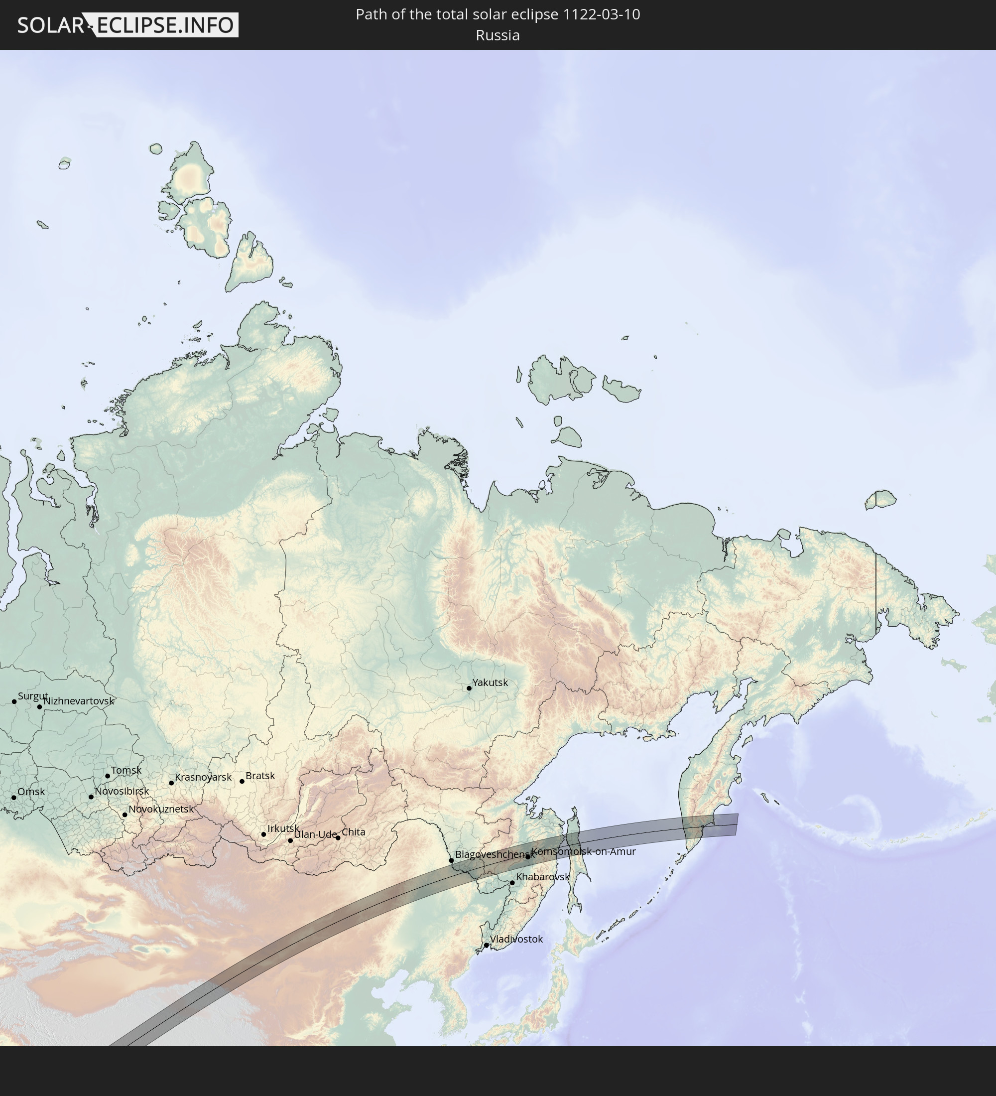 Russia
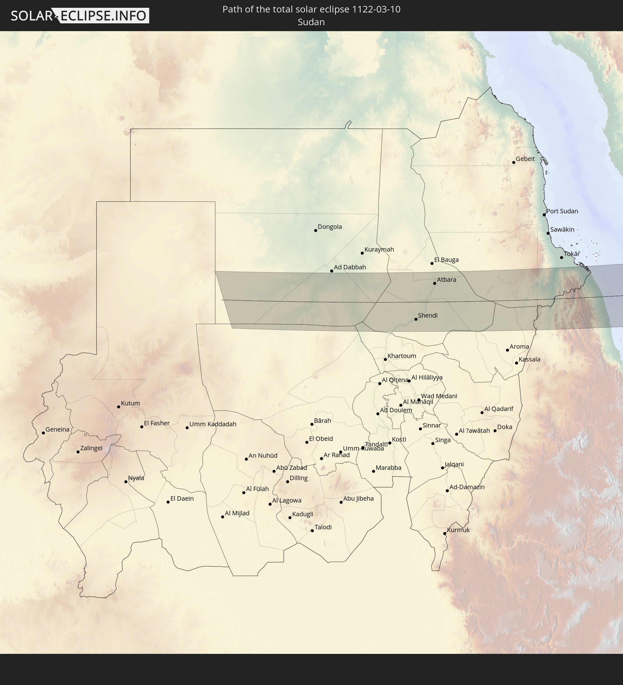 Sudan
Sudan
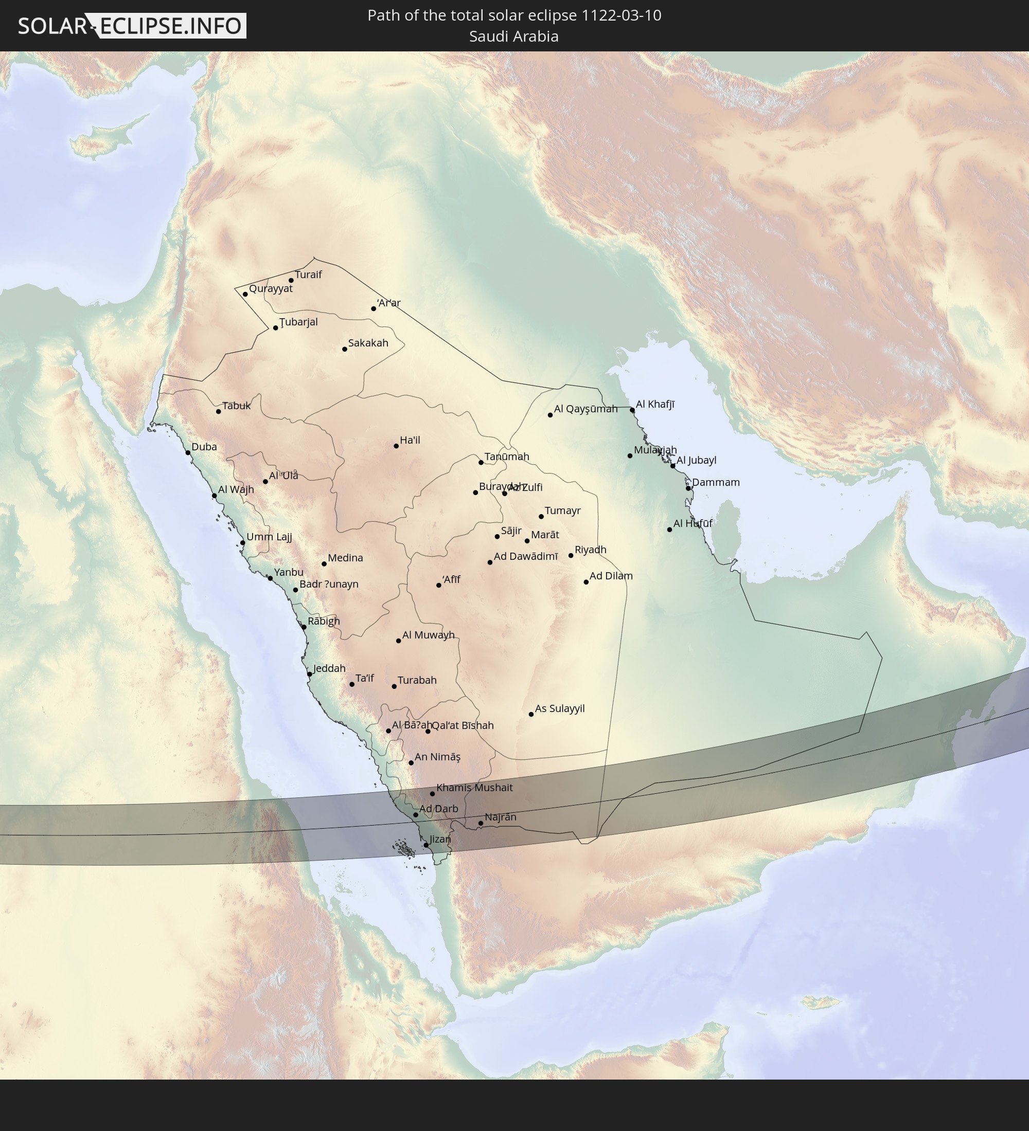 Saudi Arabia
 Eritrea
 Yemen
Yemen
 Oman
Oman
 Pakistan
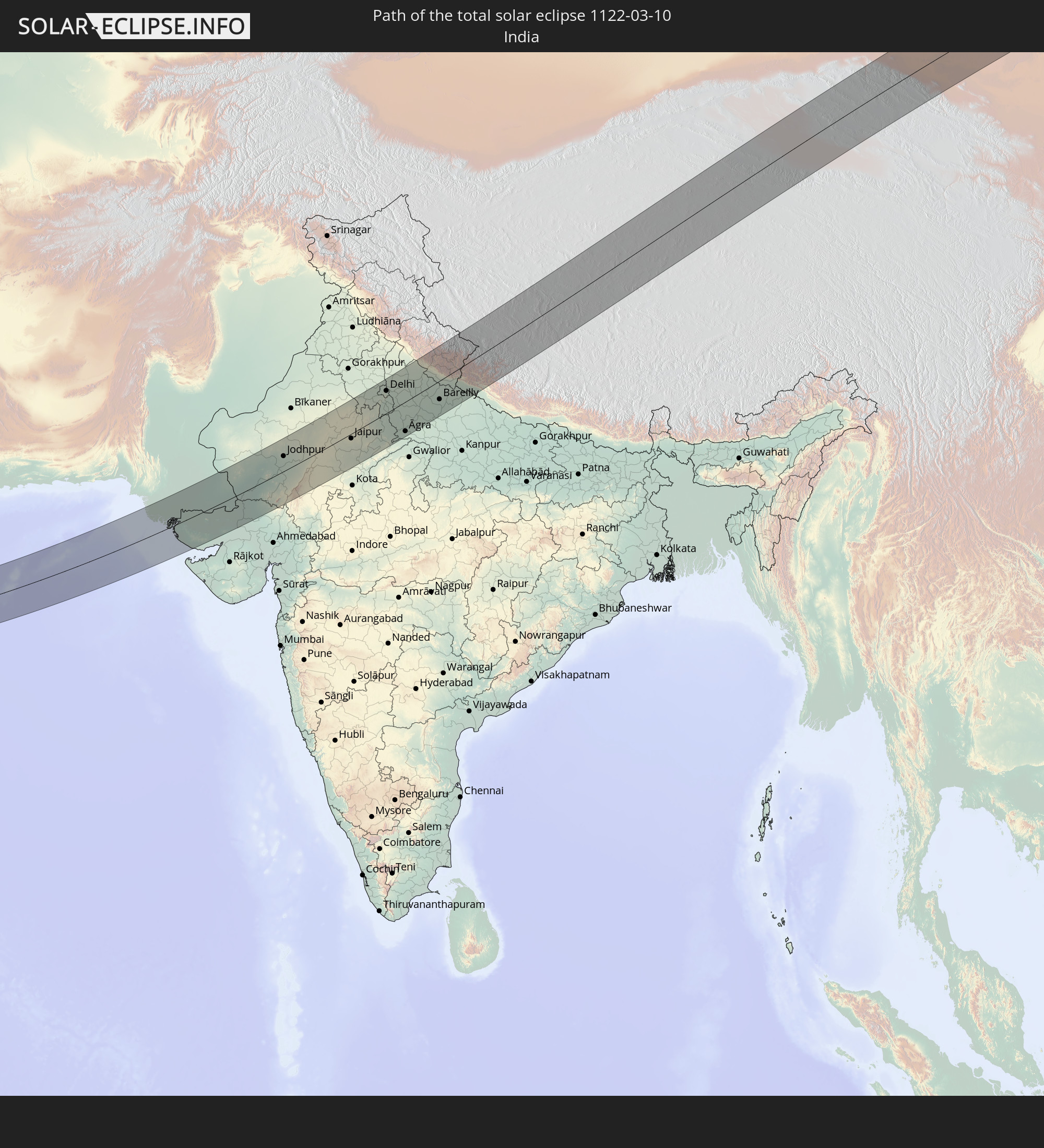 India
India
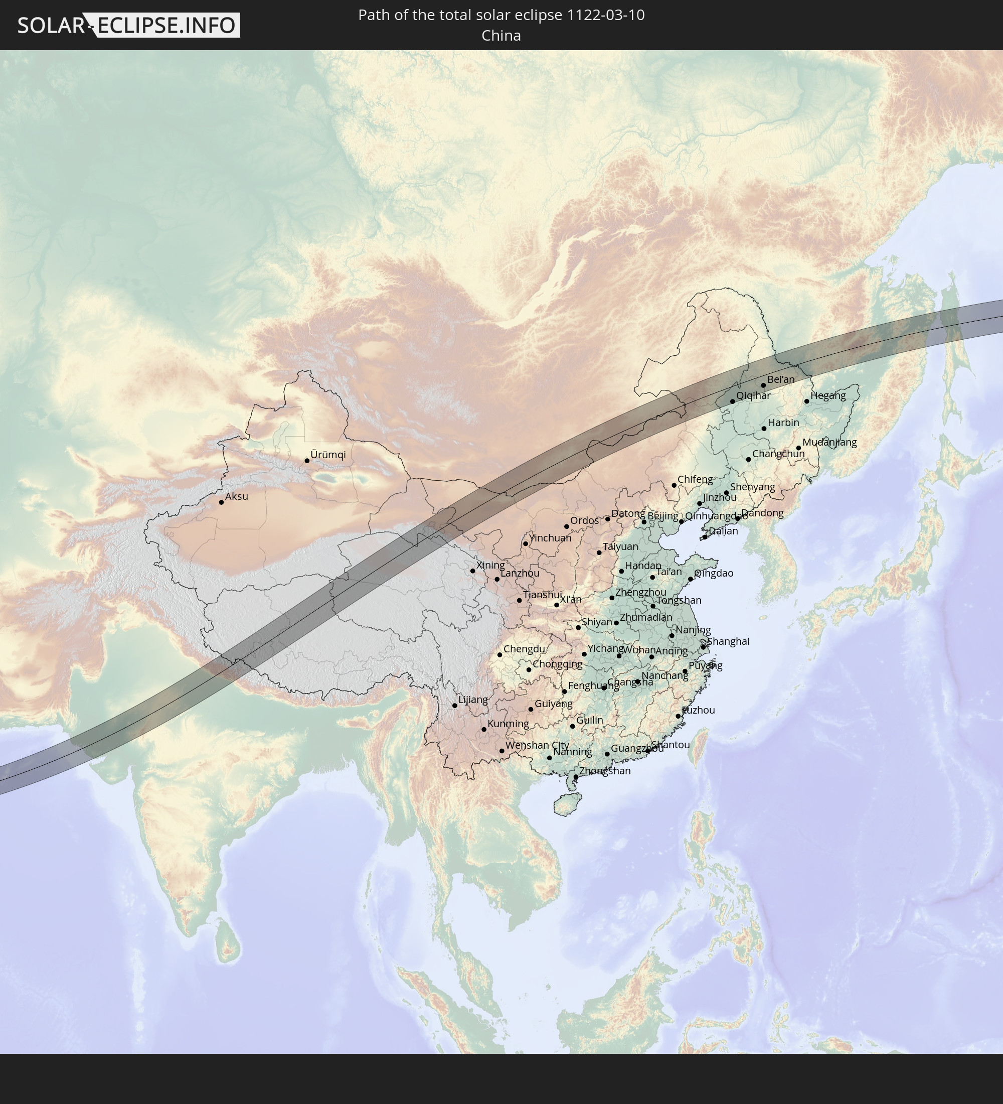 China
China
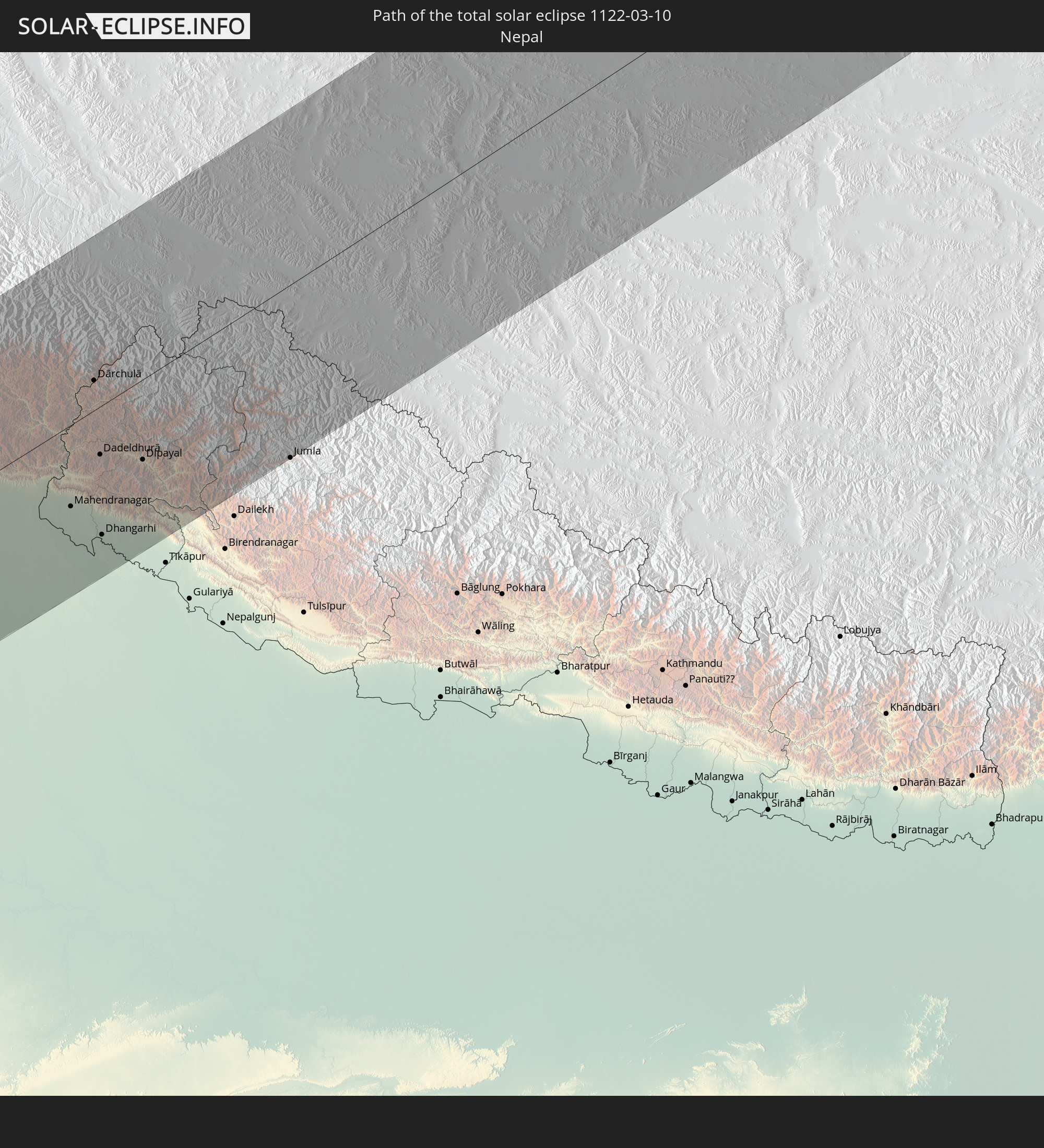 Nepal
Nepal
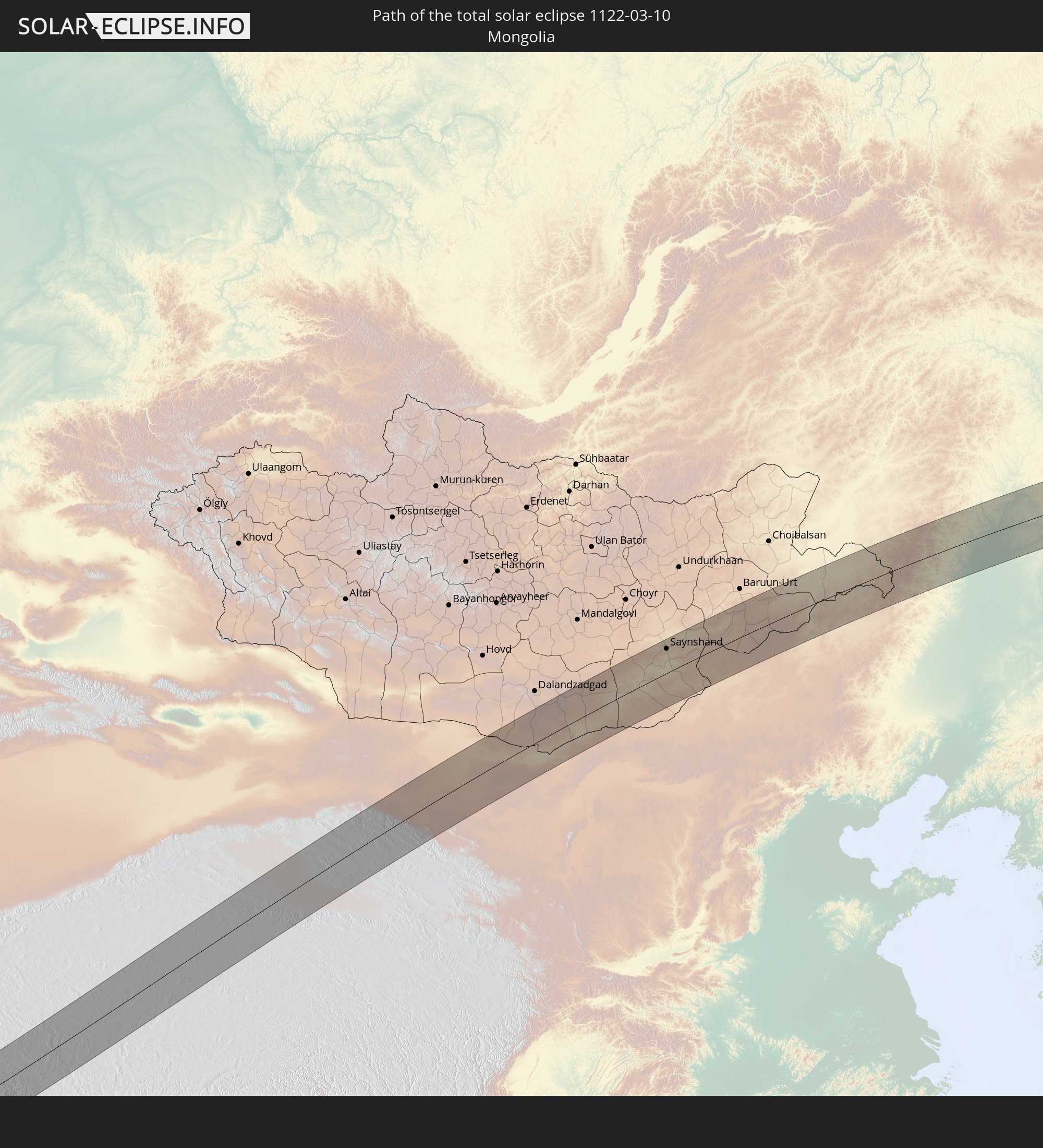 Mongolia
In den folgenden Ländern ist die Sonnenfinsternis partiell zu sehen
 Russia
 Svalbard and Jan Mayen
 Norway
 Libya
Libya
 Sweden
 Czechia
 Democratic Republic of the Congo
 Poland
 Hungary
 Slovakia
 Serbia
 Åland Islands
 Greece
 Romania
 Republic of Macedonia
 Finland
 Lithuania
 Latvia
 Estonia
 Sudan
Sudan
 Zambia
 Ukraine
 Bulgaria
 Belarus
 Egypt
Egypt
 Turkey
 Moldova
 Rwanda
 Burundi
 Tanzania
 Uganda
 Mozambique
 Cyprus
 Malawi
 Ethiopia
 Kenya
Kenya
 State of Palestine
 Israel
 Saudi Arabia
 Jordan
 Lebanon
 Syria
Syria
 Eritrea
 Iraq
Iraq
 Georgia
 French Southern and Antarctic Lands
 Somalia
 Djibouti
 Yemen
Yemen
 Madagascar
 Comoros
 Armenia
 Iran
Iran
 Azerbaijan
 Mayotte
 Seychelles
 Kazakhstan
 Kuwait
 Bahrain
 Qatar
Qatar
 United Arab Emirates
 Oman
Oman
 Turkmenistan
 Uzbekistan
 Mauritius
 Afghanistan
 Pakistan
 Tajikistan
 India
India
 Kyrgyzstan
 British Indian Ocean Territory
 Maldives
 China
China
 Sri Lanka
 Nepal
Nepal
 Mongolia
 Bangladesh
 Bhutan
 Myanmar
 Indonesia
 Thailand
 Malaysia
 Laos
Laos
 Vietnam
 Cambodia
 Macau
Macau
 Hong Kong
 Taiwan
 Philippines
 Japan
Japan
 North Korea
 South Korea
 Northern Mariana Islands
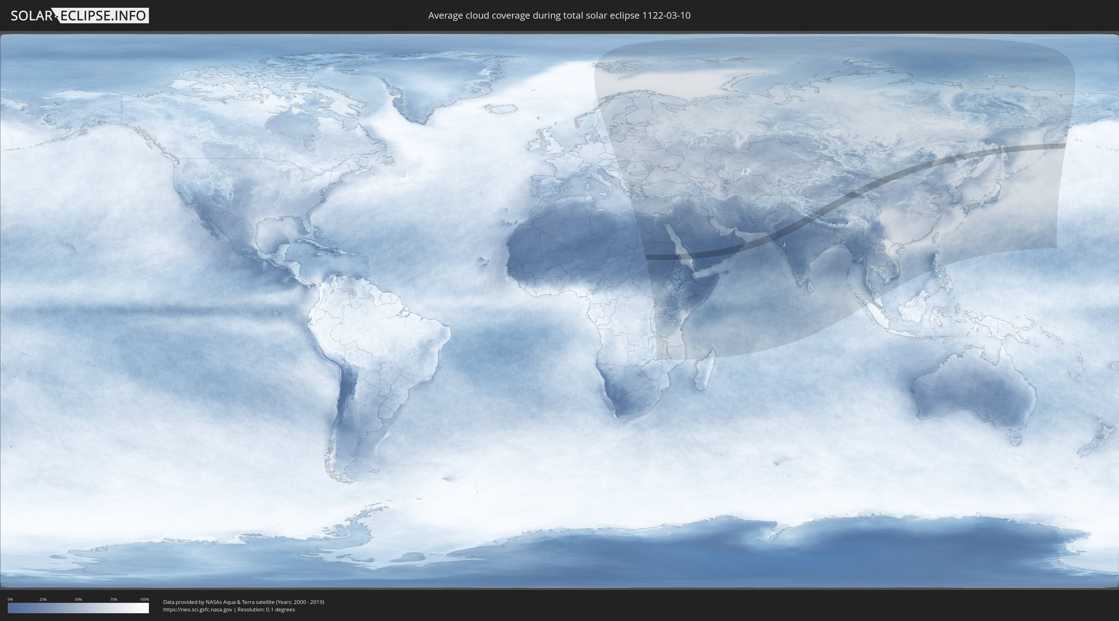
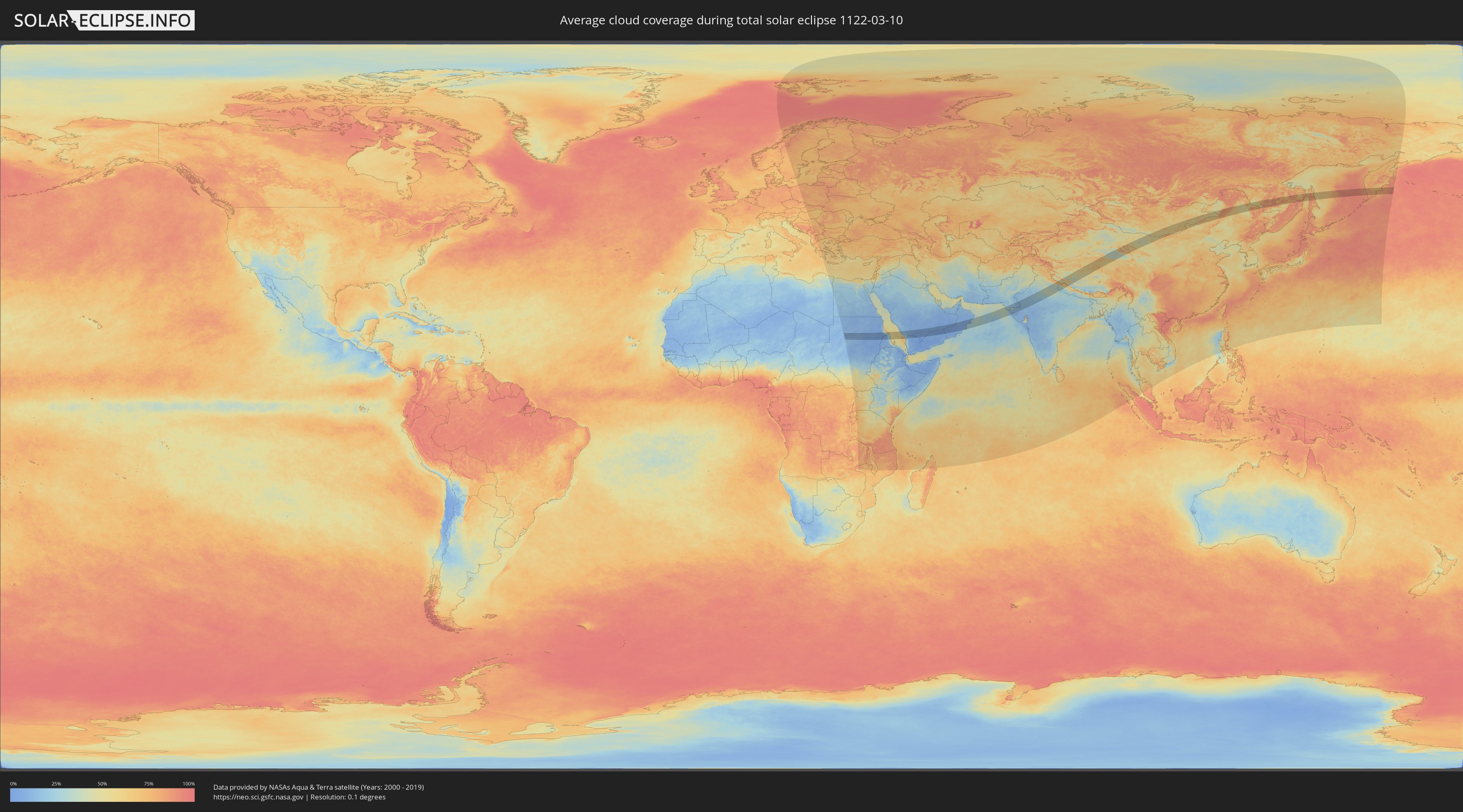
How will be the weather during the total solar eclipse on 03/10/1122?
Where is the best place to see the total solar eclipse of 03/10/1122?
The following maps show the average cloud coverage for the day of the total solar eclipse.
With the help of these maps, it is possible to find the place along the eclipse path, which has the best
chance of a cloudless sky.
Nevertheless, you should consider local circumstances and inform about the weather of your chosen
observation site.
The data is provided by NASAs satellites
AQUA and TERRA.
The cloud maps are averaged over a period of 19 years (2000 - 2019).
Detailed country maps
 Russia
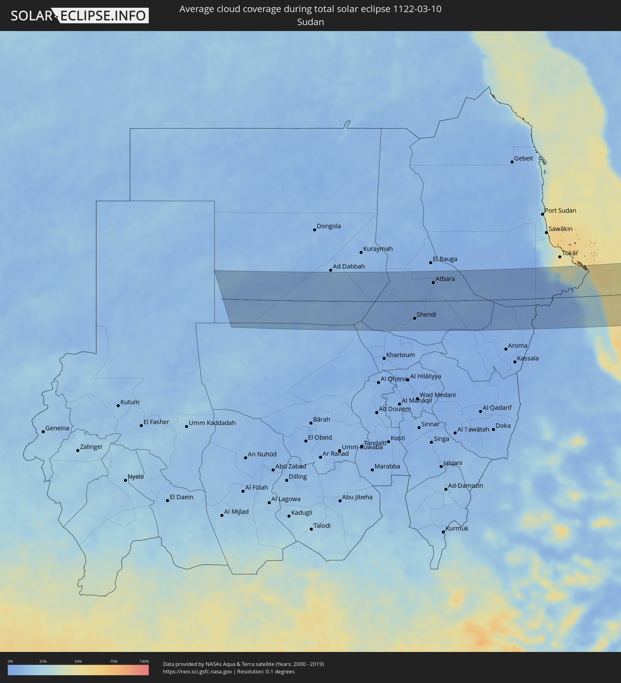 Sudan
Sudan
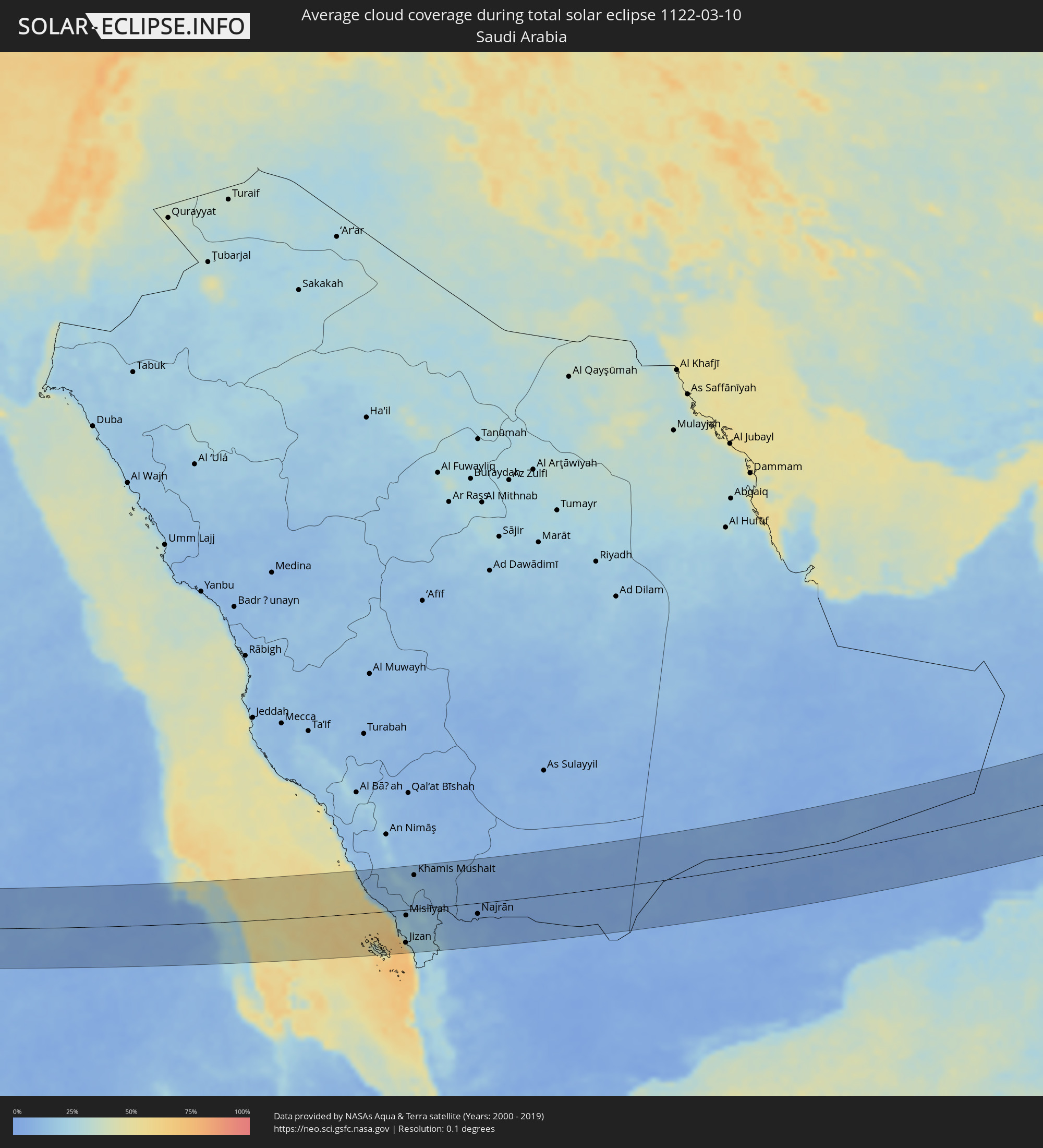 Saudi Arabia
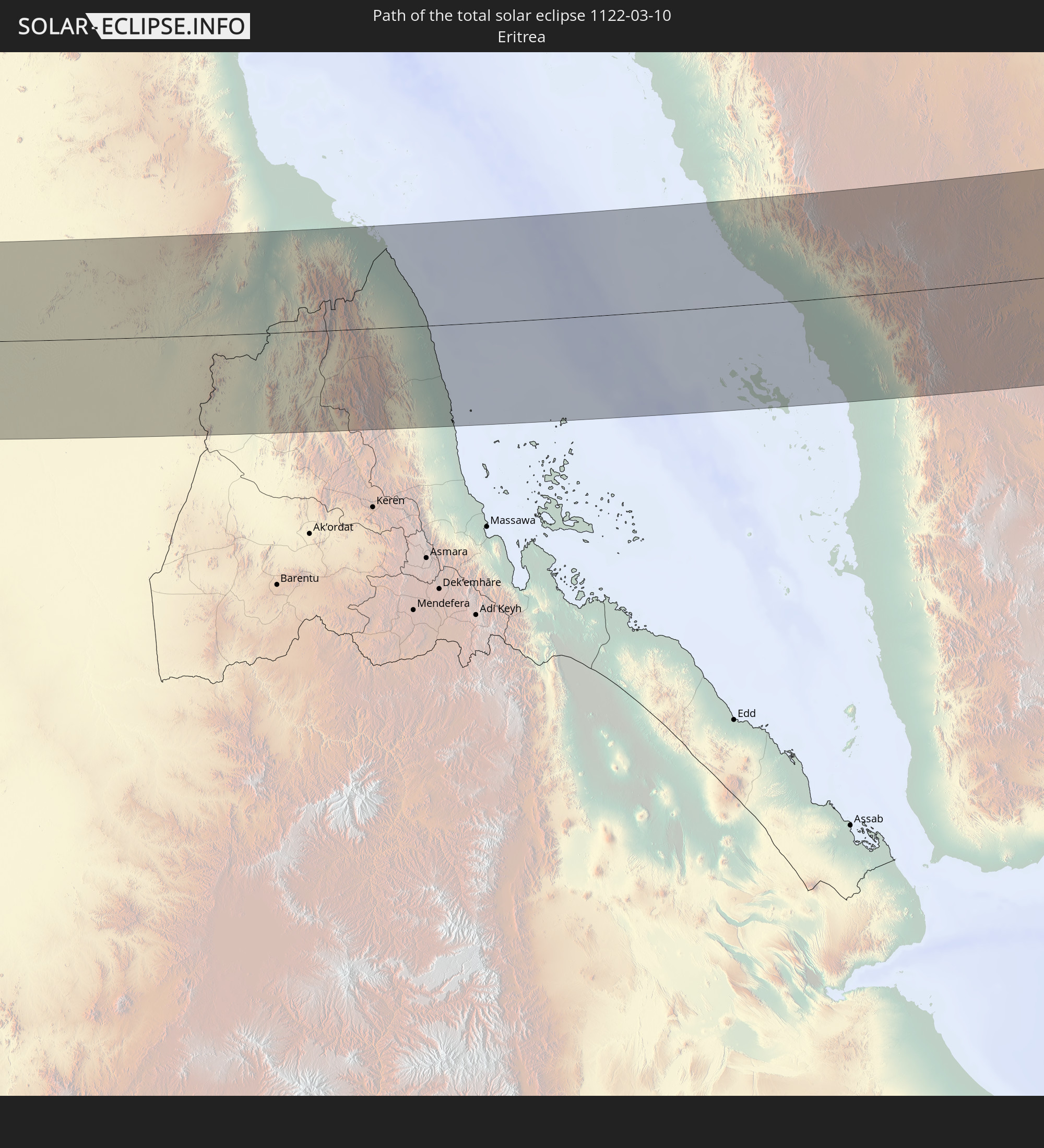
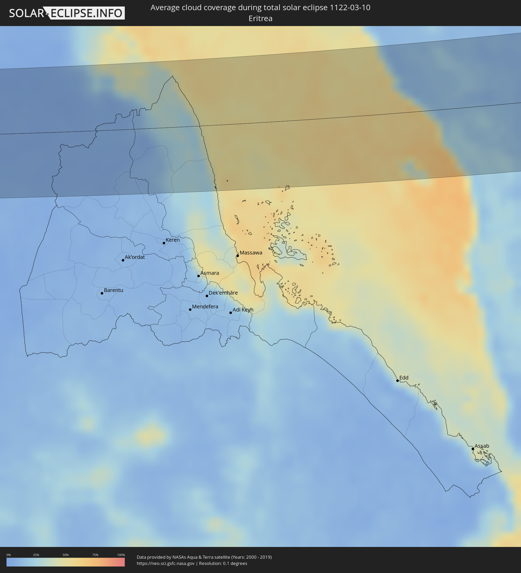 Eritrea
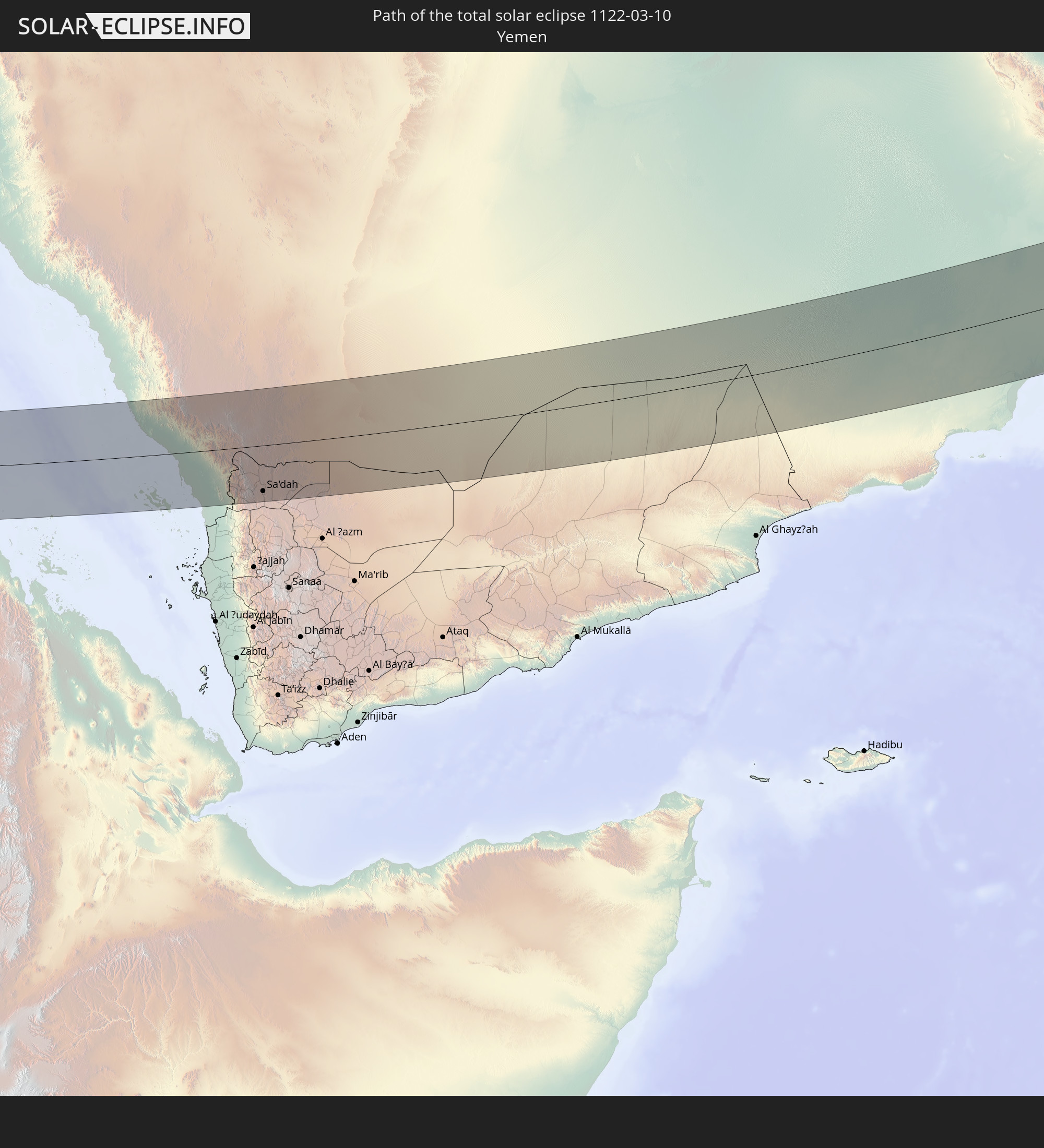
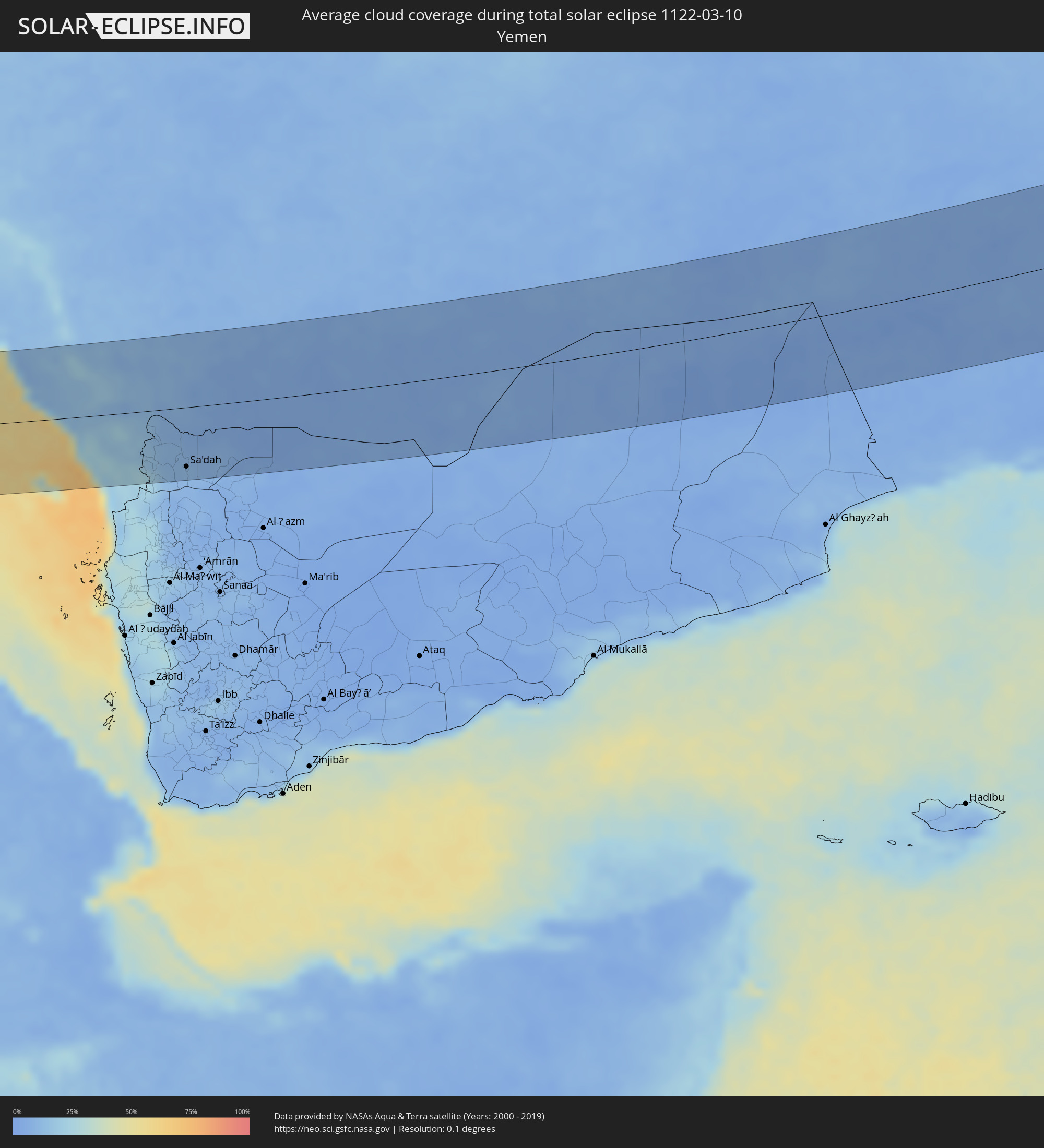 Yemen
Yemen
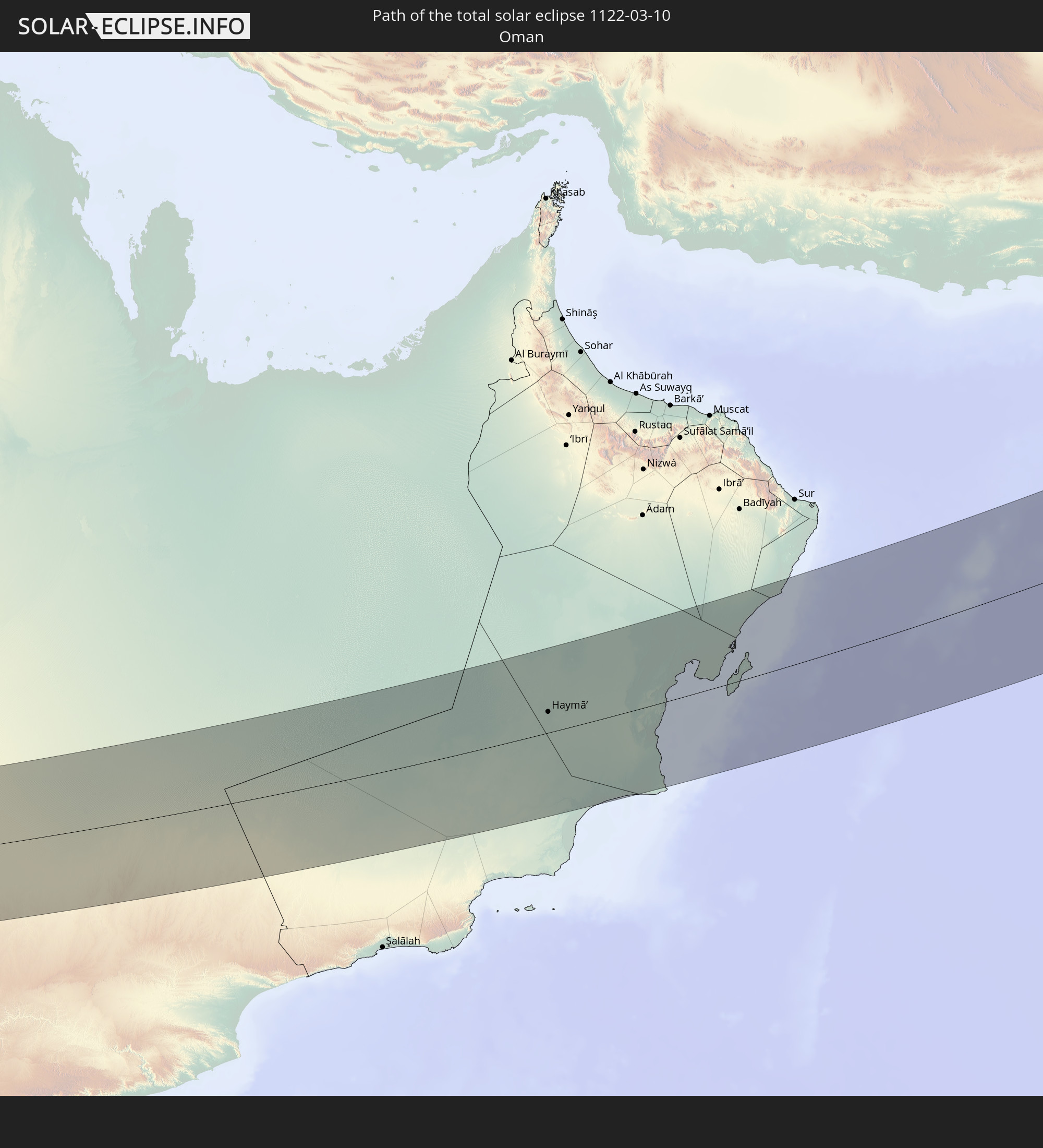
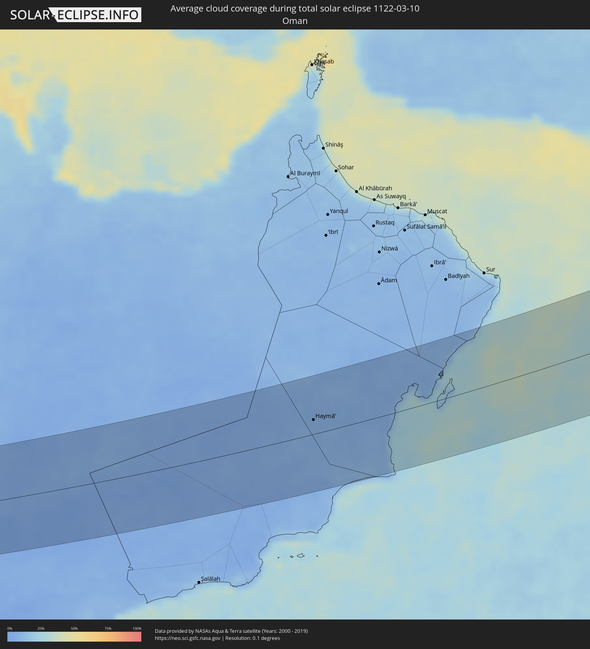 Oman
Oman
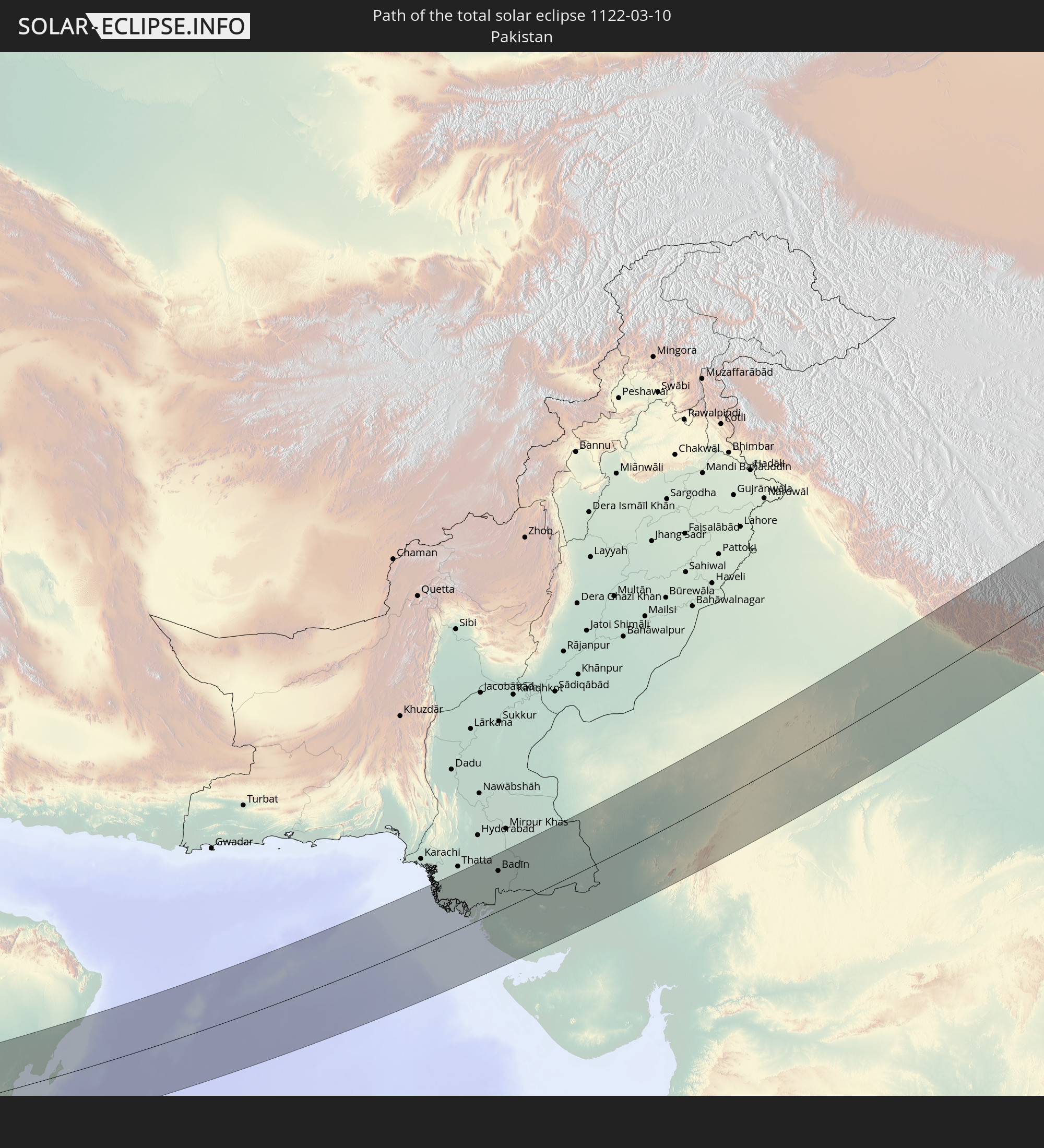
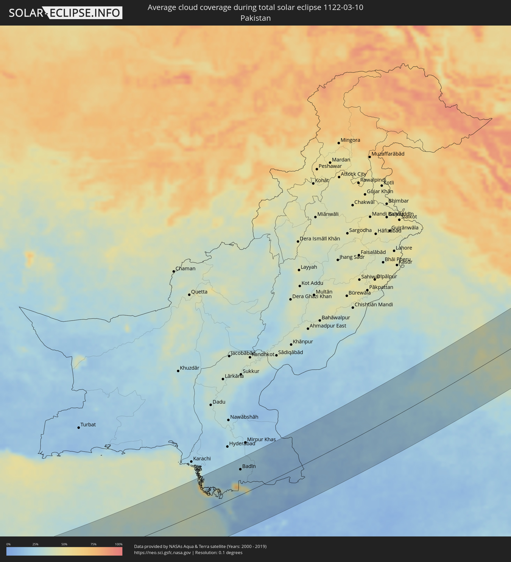 Pakistan
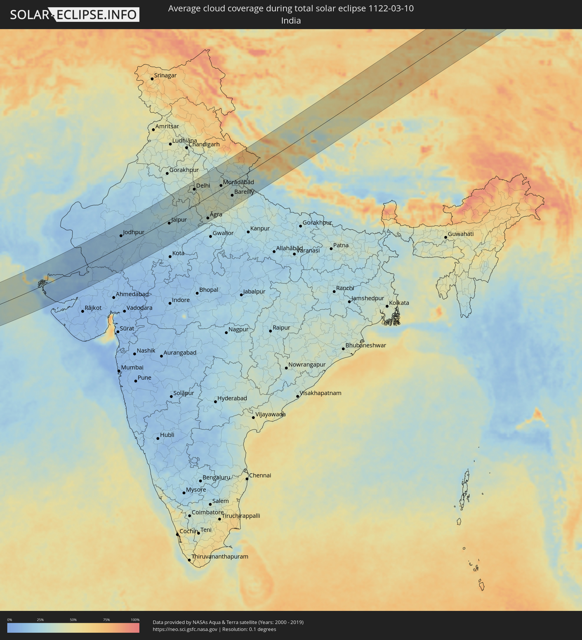 India
India
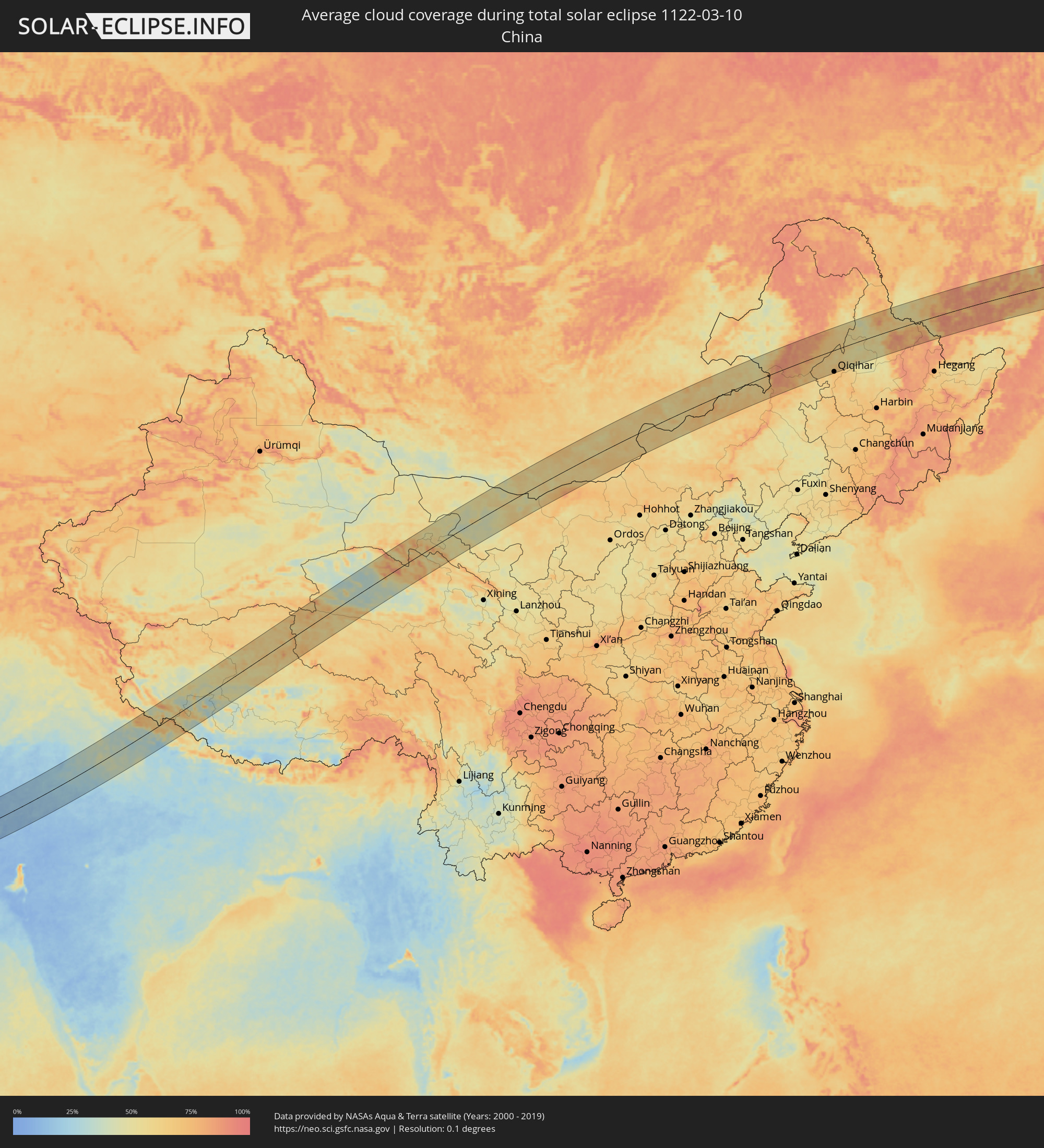 China
China
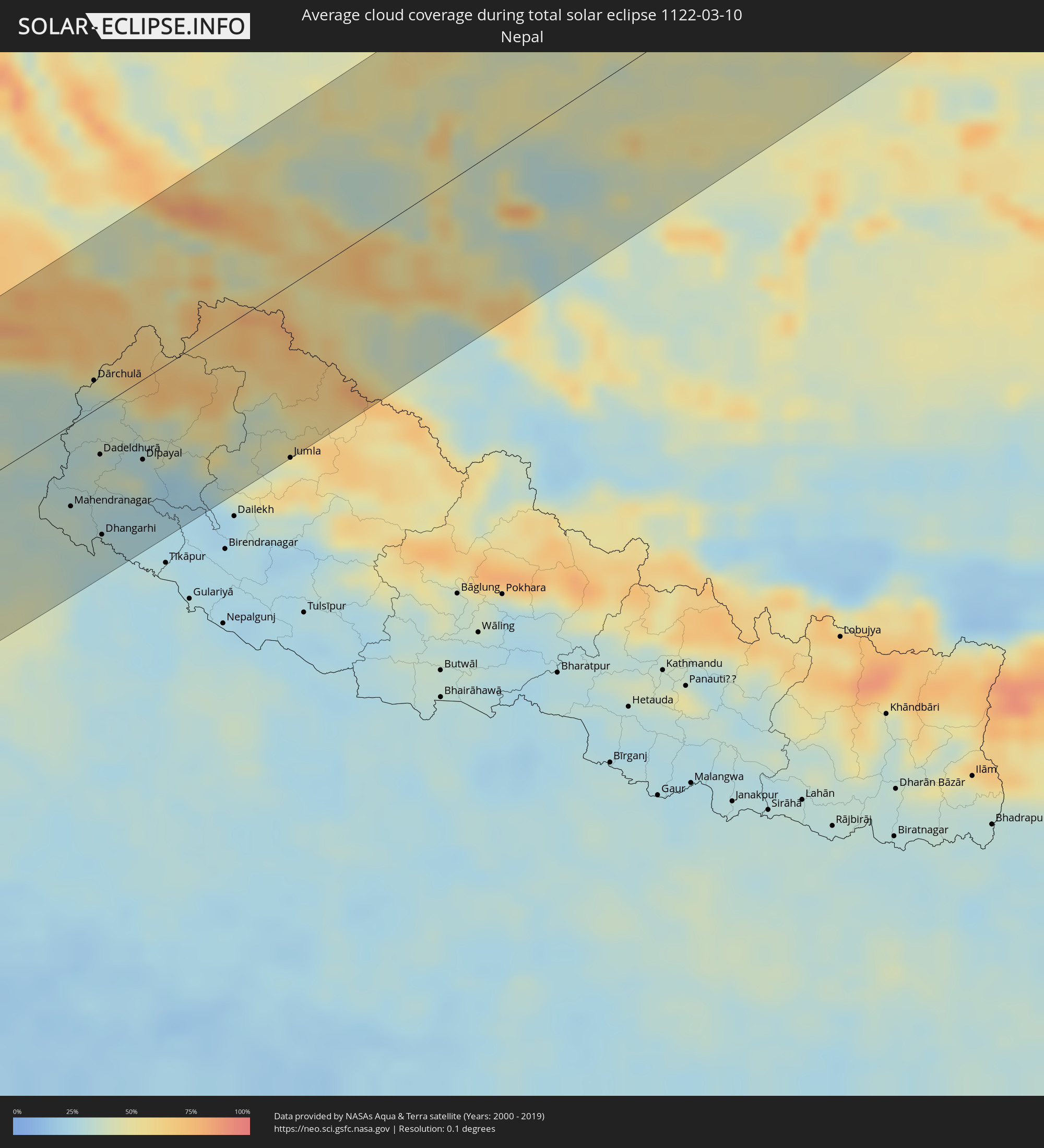 Nepal
Nepal
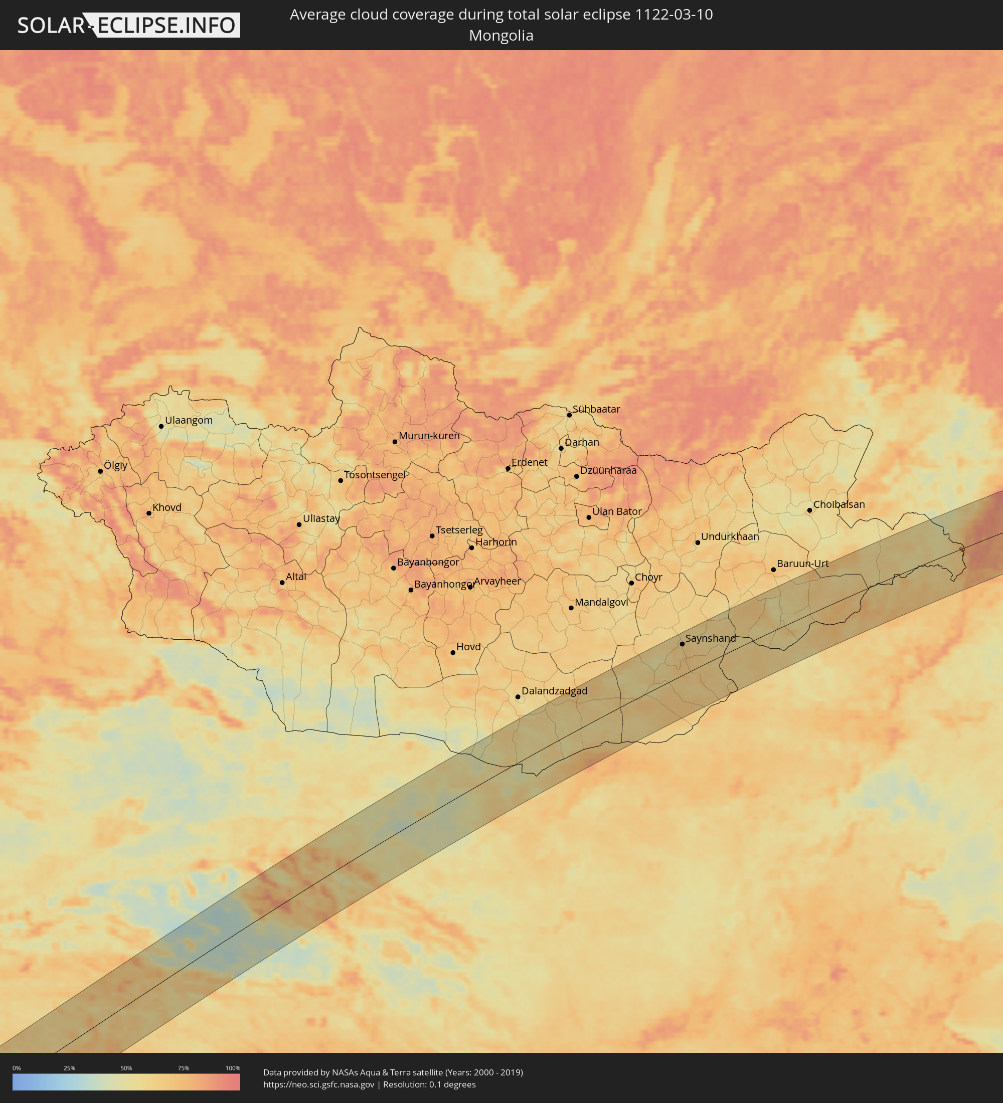 Mongolia
Cities inside the path of the eclipse
The following table shows all locations with a population of more than 5,000 inside the eclipse path. Cities which have more than 100,000 inhabitants are marked bold. A click at the locations opens a detailed map.
| City | Type | Eclipse duration | Local time of max. eclipse | Distance to central line | Ø Cloud coverage |
|
El Matama, River Nile
|
total | - | 06:30:54 UTC+02:10 | 53 km | 6% |
|
Shendi, River Nile
|
total | - | 06:30:54 UTC+02:10 | 55 km | 6% |
|
Ed Damer, River Nile
|
total | - | 06:32:00 UTC+02:10 | 45 km | 6% |
|
Berber, River Nile
|
total | - | 06:32:28 UTC+02:10 | 93 km | 5% |
|
Atbara, River Nile
|
total | - | 06:32:07 UTC+02:10 | 57 km | 5% |
|
Farasān, Jizan
|
total | - | 07:30:43 UTC+03:06 | 93 km | 44% |
|
Ad Darb, Jizan
|
total | - | 07:32:00 UTC+03:06 | 19 km | 13% |
|
Abha, 'Asir
|
total | - | 07:32:44 UTC+03:06 | 71 km | 19% |
|
Jizan, Jizan
|
total | - | 07:31:10 UTC+03:06 | 76 km | 40% |
|
Mislīyah, Jizan
|
total | - | 07:31:51 UTC+03:06 | 13 km | 20% |
|
Şabyā, Jizan
|
total | - | 07:31:31 UTC+03:06 | 48 km | 24% |
|
Khamis Mushait, 'Asir
|
total | - | 07:32:58 UTC+03:06 | 78 km | 14% |
|
Mizhirah, Jizan
|
total | - | 07:31:12 UTC+03:06 | 85 km | 35% |
|
Abū ‘Arīsh, Jizan
|
total | - | 07:31:25 UTC+03:06 | 70 km | 24% |
|
Sa'dah, Şa‘dah
|
total | - | 07:31:54 UTC+03:06 | 82 km | 10% |
|
Najrān, Najran
|
total | - | 07:32:47 UTC+03:06 | 25 km | 6% |
|
Haymā’, Al Wusţá
|
total | - | 08:20:55 UTC+03:41 | 28 km | 6% |
|
Chuhar Jamāli, Sindh
|
total | - | 09:31:18 UTC+04:28 | 93 km | 21% |
|
Mīrpur Batoro, Sindh
|
total | - | 09:32:18 UTC+04:28 | 116 km | 22% |
|
Jāti, Sindh
|
total | - | 09:31:43 UTC+04:28 | 78 km | 18% |
|
Kario, Sindh
|
total | - | 09:33:00 UTC+04:28 | 109 km | 22% |
|
Talhār, Sindh
|
total | - | 09:33:29 UTC+04:28 | 108 km | 23% |
|
Badīn, Sindh
|
total | - | 09:33:10 UTC+04:28 | 84 km | 23% |
|
Rājo Khanāni, Sindh
|
total | - | 09:33:43 UTC+04:28 | 116 km | 22% |
|
Tando Bāgo, Sindh
|
total | - | 09:33:36 UTC+04:28 | 92 km | 23% |
|
Kadhan, Sindh
|
total | - | 09:33:08 UTC+04:28 | 60 km | 19% |
|
Naukot, Sindh
|
total | - | 09:34:27 UTC+04:28 | 80 km | 20% |
|
Kunri, Sindh
|
total | - | 09:35:15 UTC+04:28 | 104 km | 19% |
|
Diplo, Sindh
|
total | - | 09:34:09 UTC+04:28 | 32 km | 16% |
|
Nabīsar, Sindh
|
total | - | 09:35:12 UTC+04:28 | 90 km | 18% |
|
Umarkot, Sindh
|
total | - | 09:35:50 UTC+04:28 | 115 km | 19% |
|
Mithi, Sindh
|
total | - | 09:34:57 UTC+04:28 | 50 km | 15% |
|
Islāmkot, Sindh
|
total | - | 09:35:34 UTC+04:28 | 29 km | 12% |
|
Jodhpur, Rajasthan
|
total | - | 10:36:08 UTC+05:21 | 55 km | 20% |
|
Pāli, Rajasthan
|
total | - | 10:35:57 UTC+05:21 | 9 km | 18% |
|
Ajmer, Rajasthan
|
total | - | 10:39:30 UTC+05:21 | 6 km | 23% |
|
Bhīlwāra, Rajasthan
|
total | - | 10:37:47 UTC+05:21 | 113 km | 15% |
|
Jaipur, Rajasthan
|
total | - | 10:42:27 UTC+05:21 | 17 km | 26% |
|
Alwar, Rajasthan
|
total | - | 10:45:05 UTC+05:21 | 4 km | 28% |
|
Sonīpat, Haryana
|
total | - | 10:48:02 UTC+05:21 | 121 km | 39% |
|
Delhi, NCT
|
total | - | 10:47:56 UTC+05:21 | 77 km | 34% |
|
Farīdābād, Haryana
|
total | - | 10:47:43 UTC+05:21 | 50 km | 41% |
|
Ghāziābād, Uttar Pradesh
|
total | - | 10:48:22 UTC+05:21 | 68 km | 39% |
|
Bharatpur, Rajasthan
|
total | - | 10:46:15 UTC+05:21 | 73 km | 28% |
|
Greater Noida, Uttar Pradesh
|
total | - | 10:48:18 UTC+05:21 | 47 km | 45% |
|
Mathura, Uttar Pradesh
|
total | - | 10:47:03 UTC+05:21 | 55 km | 36% |
|
Meerut, Uttar Pradesh
|
total | - | 10:49:22 UTC+05:21 | 84 km | 37% |
|
Hāpur, Uttar Pradesh
|
total | - | 10:49:08 UTC+05:21 | 57 km | 36% |
|
Āgra, Uttar Pradesh
|
total | - | 10:47:15 UTC+05:21 | 103 km | 34% |
|
Alīgarh, Uttar Pradesh
|
total | - | 10:48:26 UTC+05:21 | 39 km | 39% |
|
Morādābād, Uttar Pradesh
|
total | - | 10:51:16 UTC+05:21 | 16 km | 36% |
|
Rāmpur, Uttar Pradesh
|
total | - | 10:51:44 UTC+05:21 | 1 km | 36% |
|
Bareilly, Uttar Pradesh
|
total | - | 10:51:50 UTC+05:21 | 63 km | 33% |
|
Mahendranagar, Far Western
|
total | - | 11:14:37 UTC+05:41 | 56 km | 36% |
|
Dārchulā, Western Region
|
total | - | 10:56:16 UTC+05:21 | 21 km | 34% |
|
Dadeldhurā, Far Western
|
total | - | 11:15:41 UTC+05:41 | 33 km | 37% |
|
Dhangarhi, Far Western
|
total | - | 11:14:51 UTC+05:41 | 90 km | 32% |
|
Dipayal, Far Western
|
total | - | 11:16:21 UTC+05:41 | 55 km | 31% |
|
Burang, Tibet Autonomous Region
|
total | - | 13:37:03 UTC+08:00 | 30 km | 51% |
|
Jumla, Mid Western
|
total | - | 11:18:55 UTC+05:41 | 119 km | 44% |
|
Laojunmiao, Gansu
|
total | - | 14:19:24 UTC+08:00 | 89 km | 55% |
|
Jiayuguan, Gansu
|
total | - | 14:20:21 UTC+08:00 | 61 km | 54% |
|
Jiuquan, Gansu
|
total | - | 14:20:43 UTC+08:00 | 45 km | 57% |
|
Saynshand, East Gobi Aymag
|
total | - | 13:47:54 UTC+07:07 | 75 km | 64% |
|
Zhalantun, Inner Mongolia
|
total | - | 14:54:23 UTC+08:00 | 5 km | 72% |
|
Nianzishan, Heilongjiang
|
total | - | 14:54:46 UTC+08:00 | 50 km | 65% |
|
Longjiang, Heilongjiang
|
total | - | 14:55:09 UTC+08:00 | 77 km | 65% |
|
Gannan, Heilongjiang
|
total | - | 14:55:11 UTC+08:00 | 25 km | 61% |
|
Qiqihar, Heilongjiang
|
total | - | 14:55:55 UTC+08:00 | 97 km | 70% |
|
Fuyu, Heilongjiang
|
total | - | 14:56:09 UTC+08:00 | 61 km | 66% |
|
Nehe, Heilongjiang
|
total | - | 14:56:08 UTC+08:00 | 1 km | 63% |
|
Nenjiang, Heilongjiang
|
total | - | 14:56:06 UTC+08:00 | 64 km | 60% |
|
Bei’an, Heilongjiang
|
total | - | 14:57:51 UTC+08:00 | 64 km | 55% |
|
Konstantinovka, Amur
|
total | - | 15:37:10 UTC+08:38 | 47 km | 60% |
|
Tambovka, Amur
|
total | - | 15:36:54 UTC+08:38 | 96 km | 48% |
|
Poyarkovo, Amur
|
total | - | 15:37:42 UTC+08:38 | 33 km | 56% |
|
Raychikhinsk, Amur
|
total | - | 15:38:11 UTC+08:38 | 34 km | 64% |
|
Zavitinsk, Amur
|
total | - | 15:37:59 UTC+08:38 | 67 km | 61% |
|
Bureya, Amur
|
total | - | 15:38:29 UTC+08:38 | 28 km | 63% |
|
Novobureyskiy, Amur
|
total | - | 15:38:33 UTC+08:38 | 25 km | 64% |
|
Arkhara, Amur
|
total | - | 15:38:58 UTC+08:38 | 19 km | 57% |
|
Talakan, Amur
|
total | - | 15:38:31 UTC+08:38 | 66 km | 72% |
|
Solnechnyy, Khabarovsk Krai
|
total | - | 15:51:00 UTC+08:47 | 5 km | 86% |
|
Amursk, Khabarovsk Krai
|
total | - | 15:51:33 UTC+08:47 | 61 km | 64% |
|
Khurba, Khabarovsk Krai
|
total | - | 15:51:25 UTC+08:47 | 43 km | 68% |
|
Komsomolsk-on-Amur, Khabarovsk Krai
|
total | - | 15:51:22 UTC+08:47 | 30 km | 73% |
|
Solnechnyy, Khabarovsk Krai
|
total | - | 15:51:21 UTC+08:47 | 27 km | 73% |
|
Aleksandrovsk-Sakhalinskiy, Sakhalin
|
total | - | 17:21:08 UTC+10:14 | 70 km | 79% |
|
Tymovskoye, Sakhalin
|
total | - | 17:21:25 UTC+10:14 | 83 km | 86% |
|
Nogliki, Sakhalin
|
total | - | 17:20:45 UTC+10:14 | 15 km | 83% |
|
Yelizovo, Kamtsjatka
|
total | - | 17:43:12 UTC+10:34 | 29 km | 70% |
|
Vilyuchinsk, Kamtsjatka
|
total | - | 17:43:28 UTC+10:34 | 1 km | 76% |
|
Petropavlovsk-Kamchatsky, Kamtsjatka
|
total | - | 17:43:23 UTC+10:34 | 12 km | 76% |