Annular solar eclipse of 08/04/1217
| Day of week: | Friday |
| Maximum duration of eclipse: | 06m01s |
| Maximum width of eclipse path: | 176 km |
| Saros cycle: | 113 |
| Coverage: | 95.2% |
| Magnitude: | 0.952 |
| Gamma: | 0.0686 |
Wo kann man die Sonnenfinsternis vom 08/04/1217 sehen?
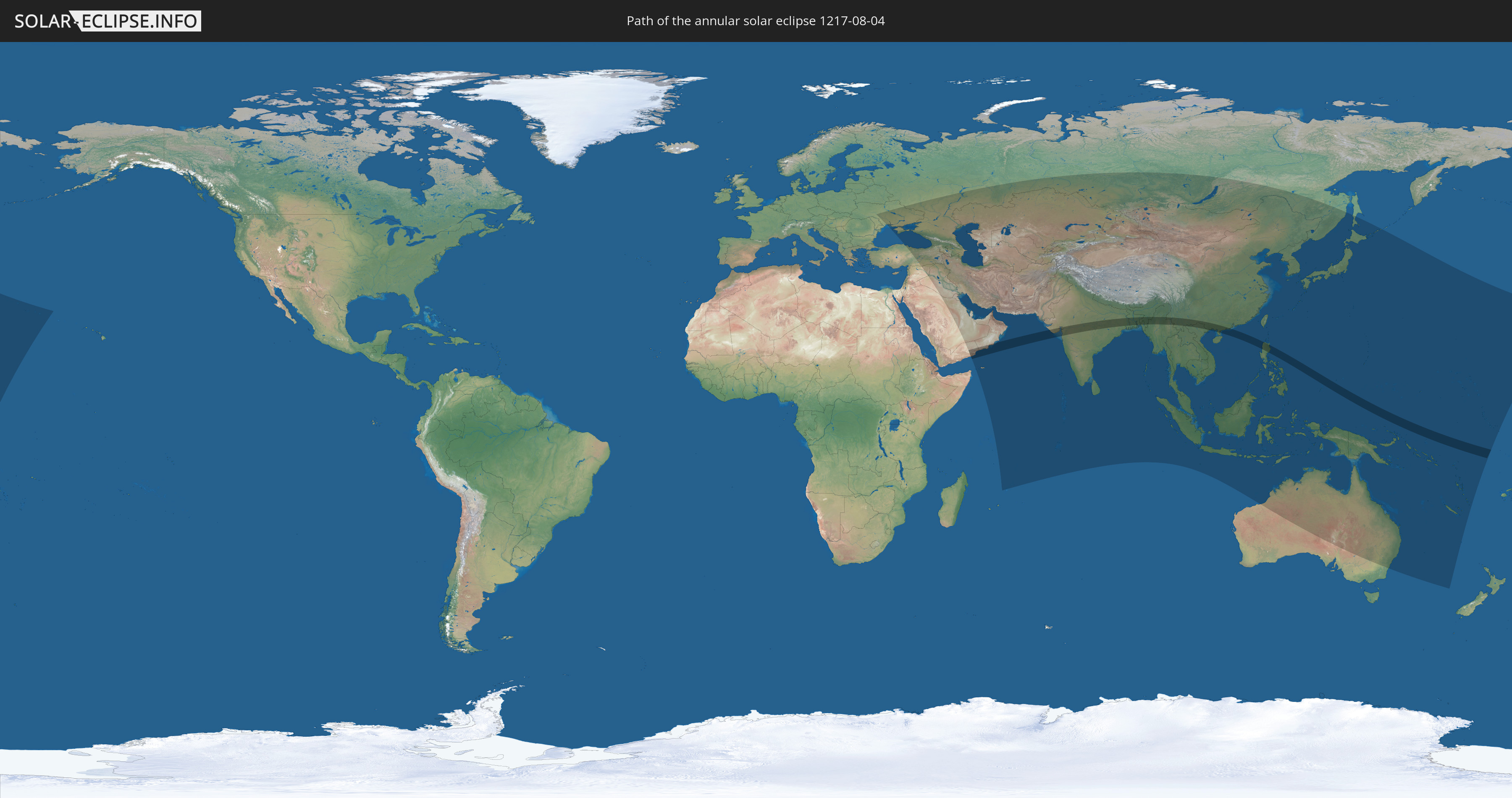
Die Sonnenfinsternis am 08/04/1217 kann man in 64 Ländern als partielle Sonnenfinsternis beobachten.
Der Finsternispfad verläuft durch 8 Länder. Nur in diesen Ländern ist sie als annular Sonnenfinsternis zu sehen.
In den folgenden Ländern ist die Sonnenfinsternis annular zu sehen
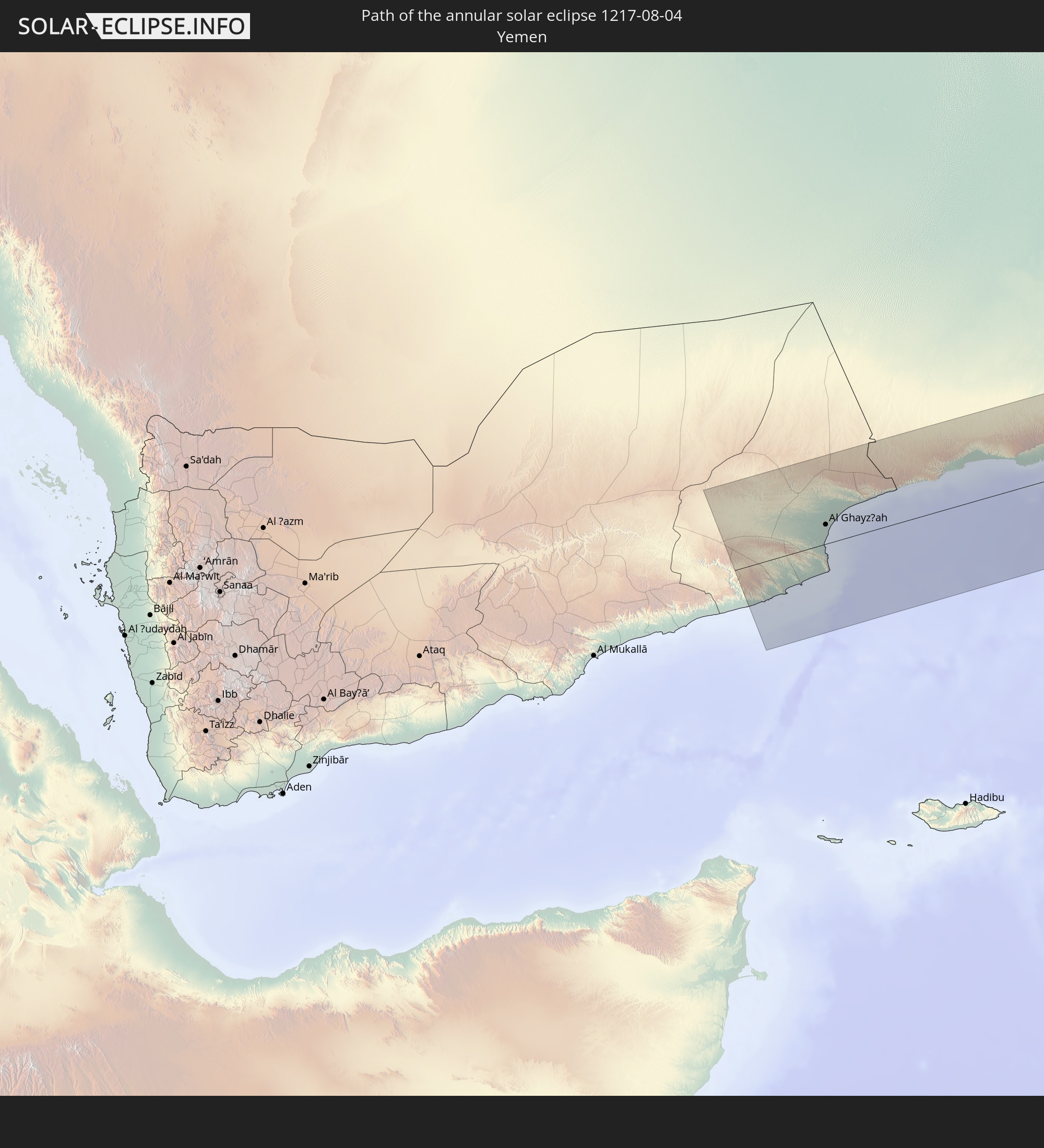 Yemen
Yemen
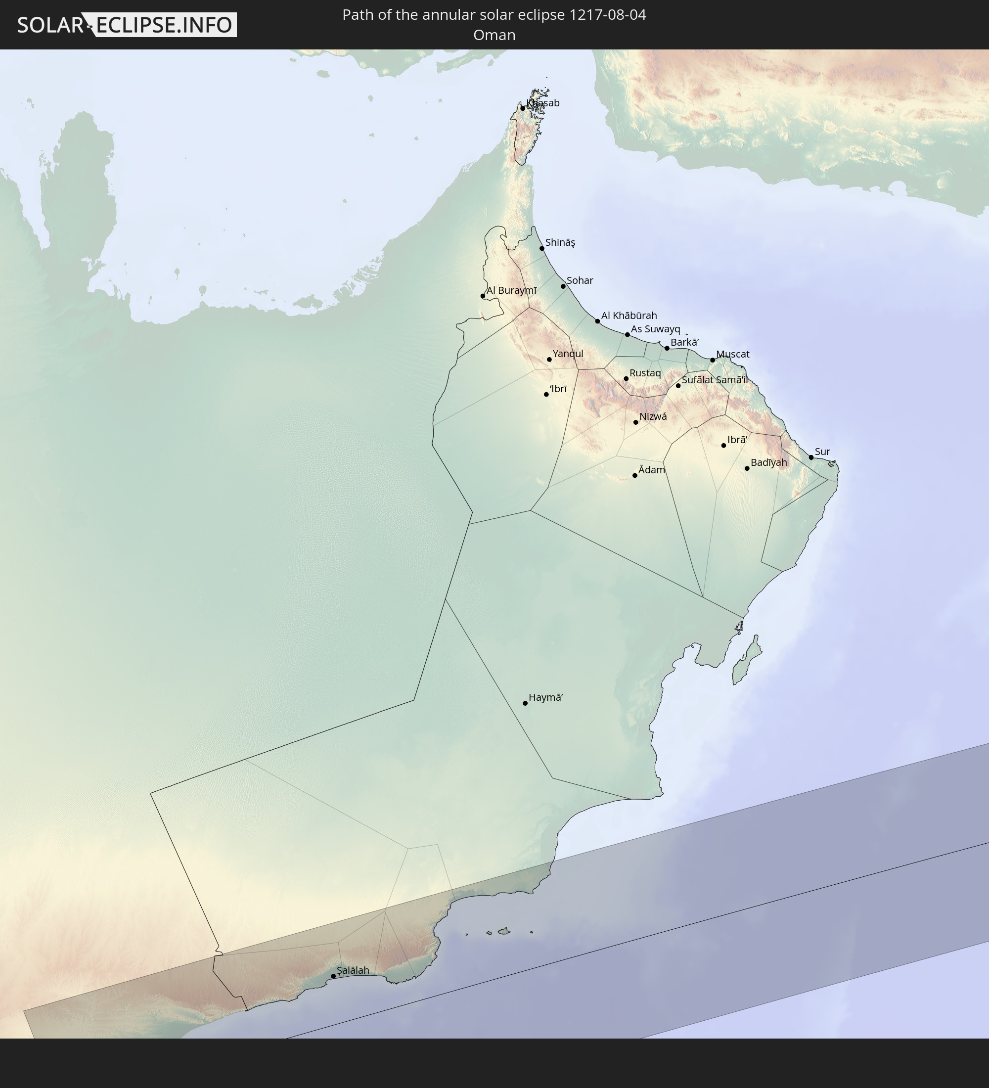 Oman
Oman
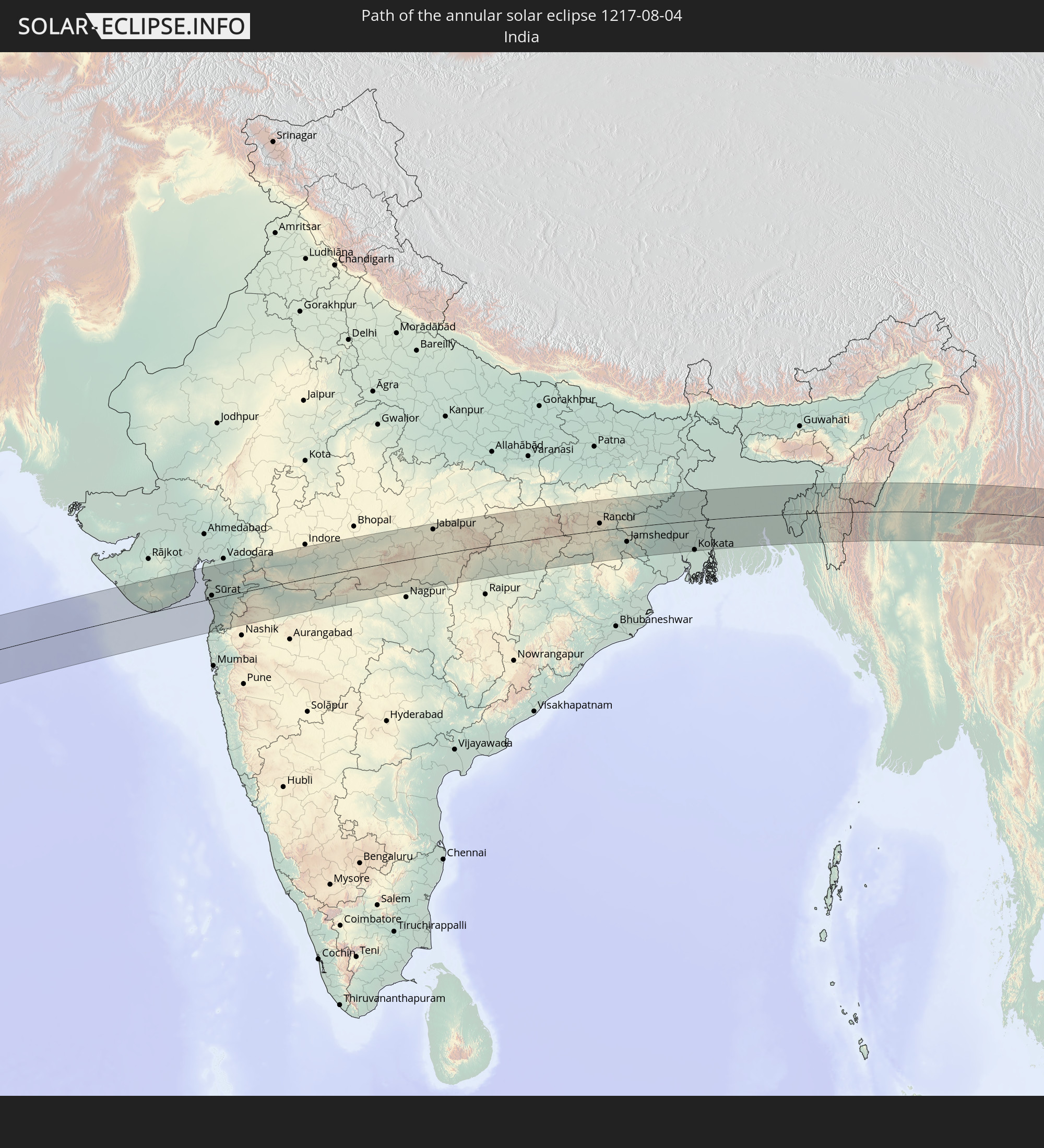 India
India
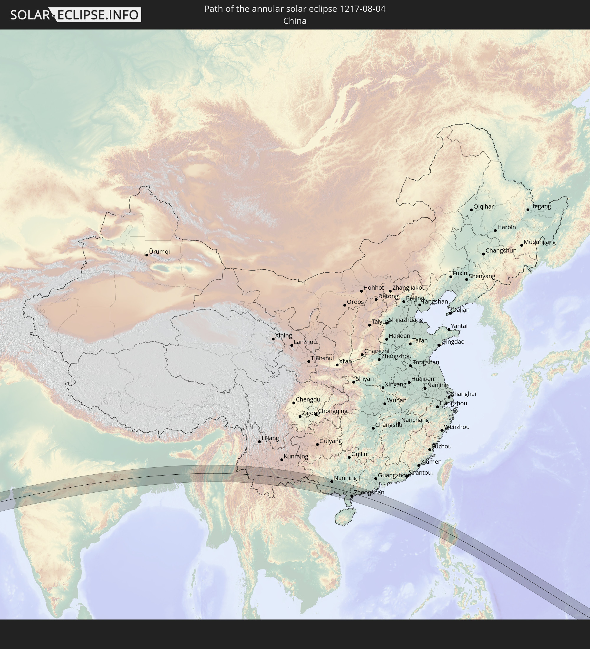 China
China
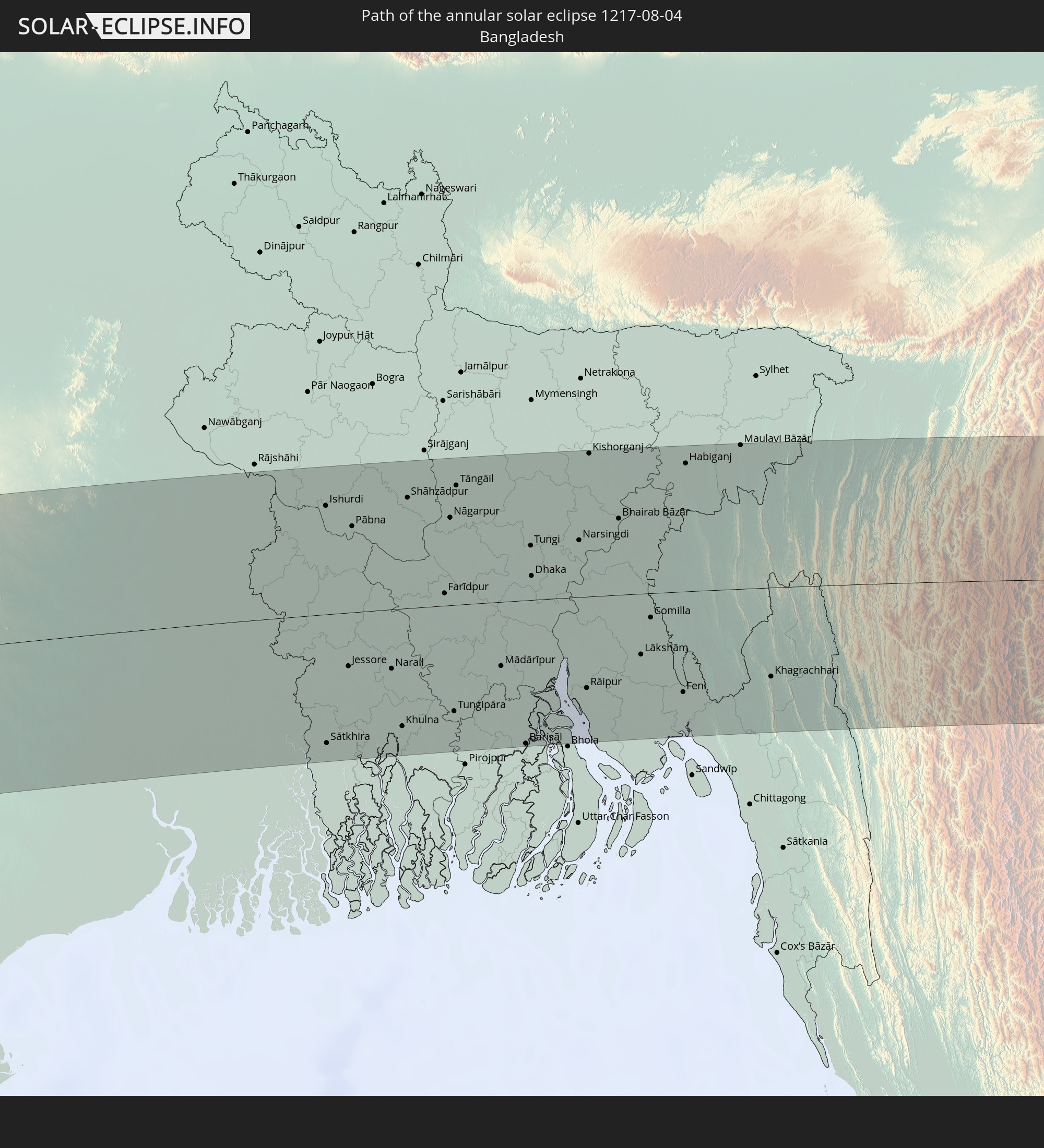 Bangladesh
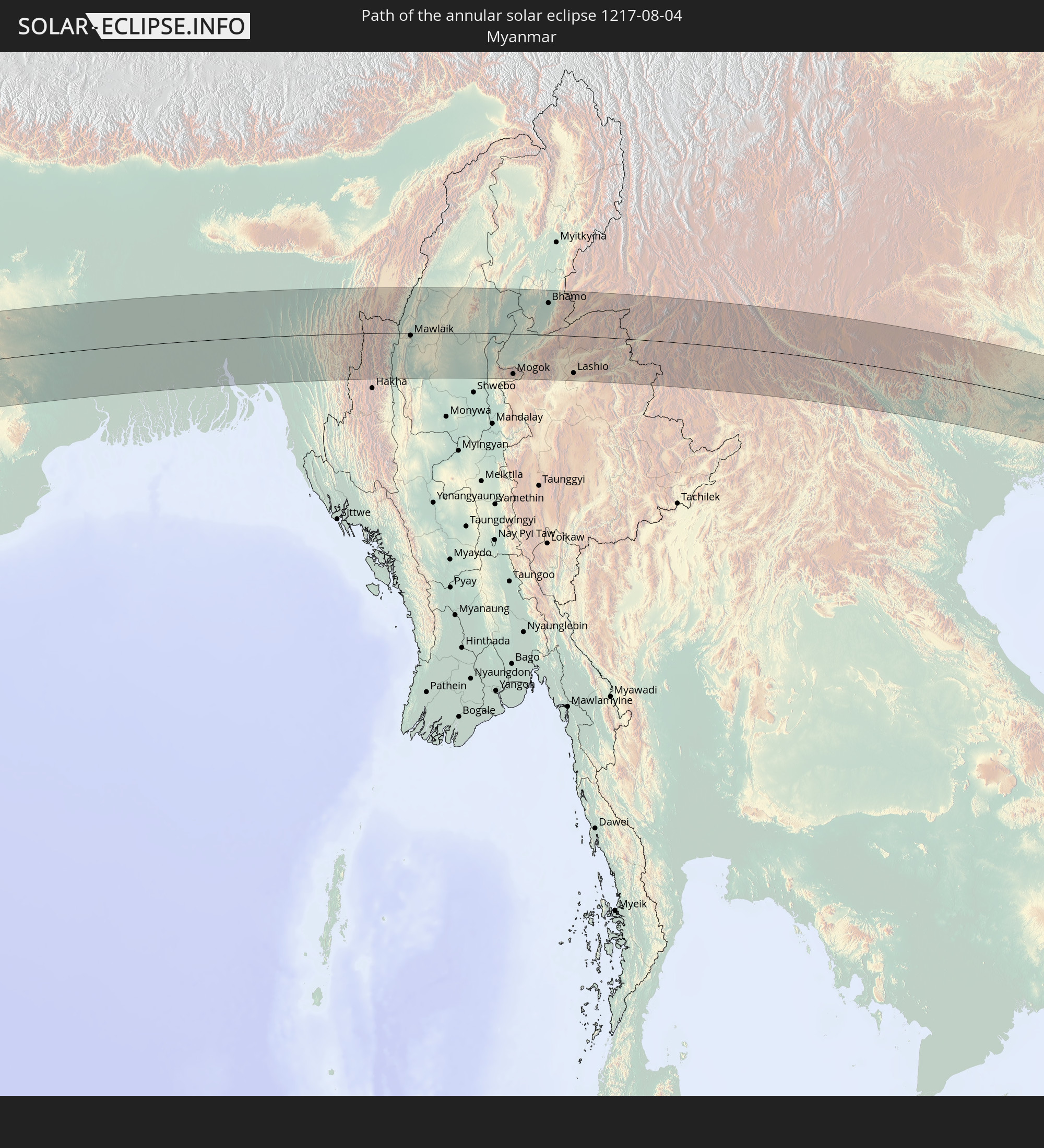 Myanmar
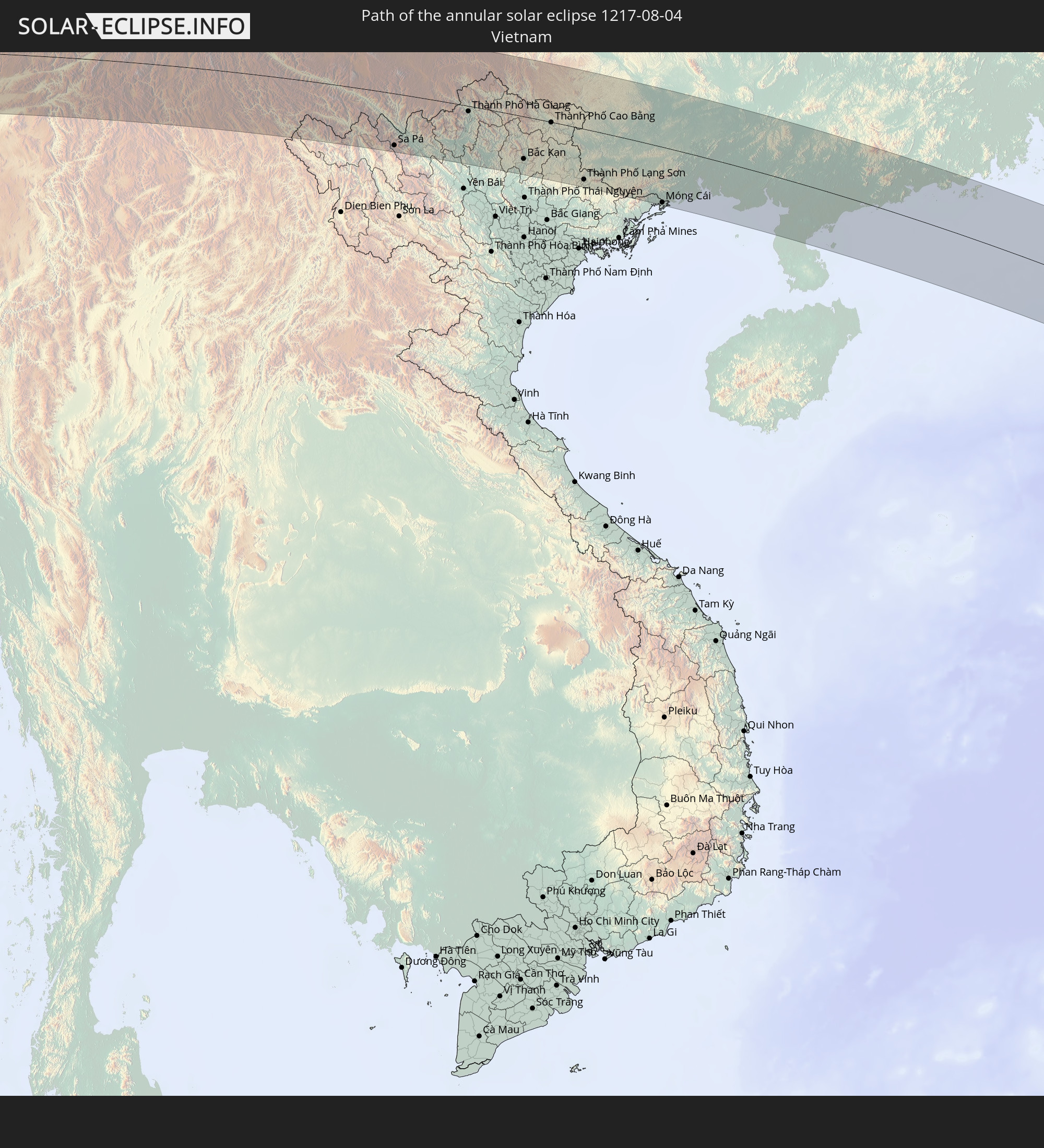 Vietnam
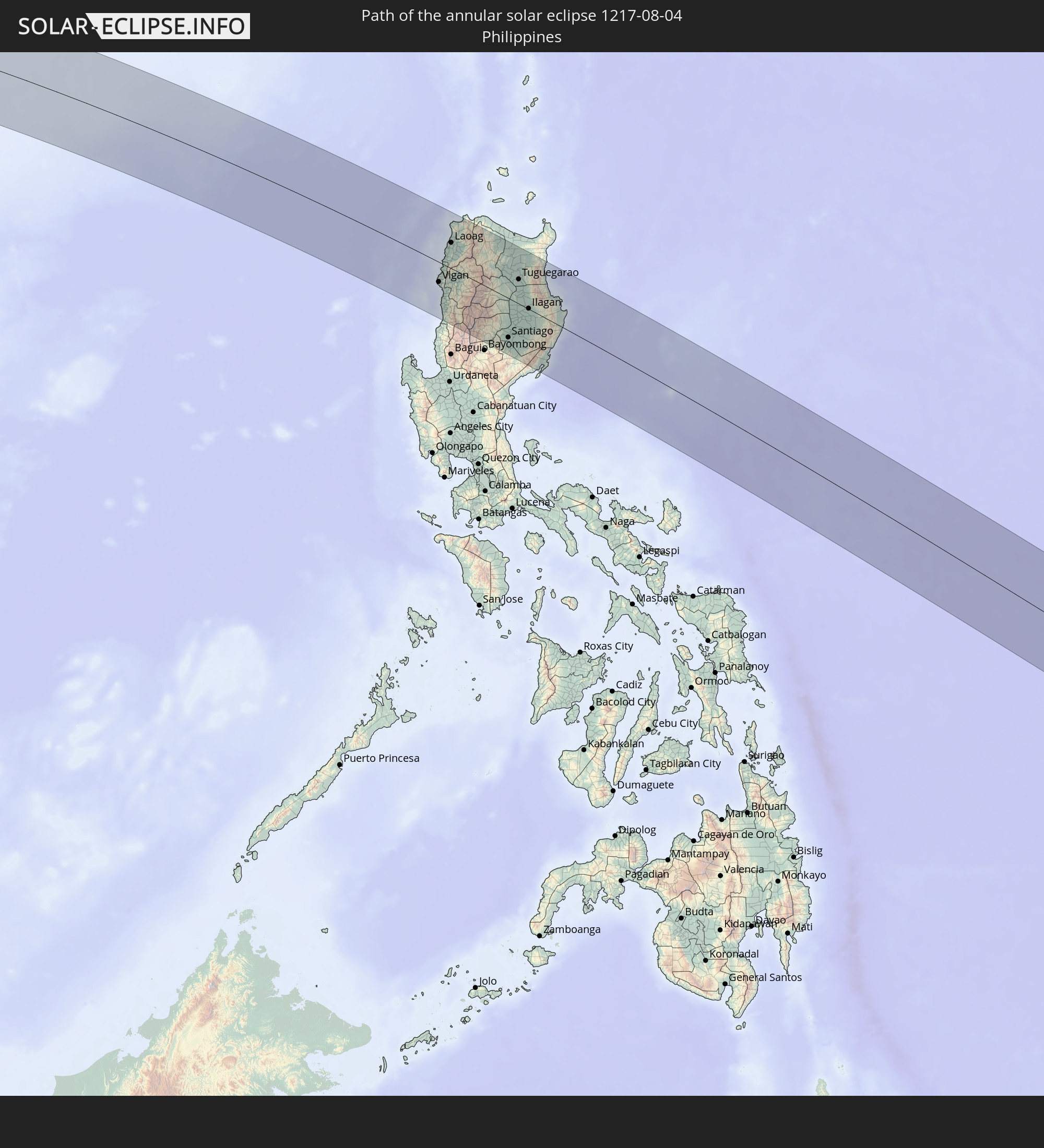 Philippines
In den folgenden Ländern ist die Sonnenfinsternis partiell zu sehen
 Russia
 United States Minor Outlying Islands
 Kiribati
 Ukraine
 Turkey
 Saudi Arabia
 Syria
Syria
 Iraq
Iraq
 Georgia
 Yemen
Yemen
 Armenia
 Iran
Iran
 Azerbaijan
 Kazakhstan
 Kuwait
 Bahrain
 Qatar
Qatar
 United Arab Emirates
 Oman
Oman
 Turkmenistan
 Uzbekistan
 Mauritius
 Afghanistan
 Pakistan
 Tajikistan
 India
India
 Kyrgyzstan
 British Indian Ocean Territory
 Maldives
 China
China
 Sri Lanka
 Nepal
Nepal
 Mongolia
 Bangladesh
 Bhutan
 Myanmar
 Indonesia
 Thailand
 Malaysia
 Laos
Laos
 Vietnam
 Cambodia
 Singapore
 Christmas Island
 Australia
 Macau
Macau
 Hong Kong
 Brunei
 Taiwan
 Philippines
 Japan
Japan
 East Timor
 North Korea
 South Korea
 Palau
Palau
 Federated States of Micronesia
 Papua New Guinea
 Guam
Guam
 Northern Mariana Islands
 Solomon Islands
 New Caledonia
 Marshall Islands
 Vanuatu
 Nauru
Nauru
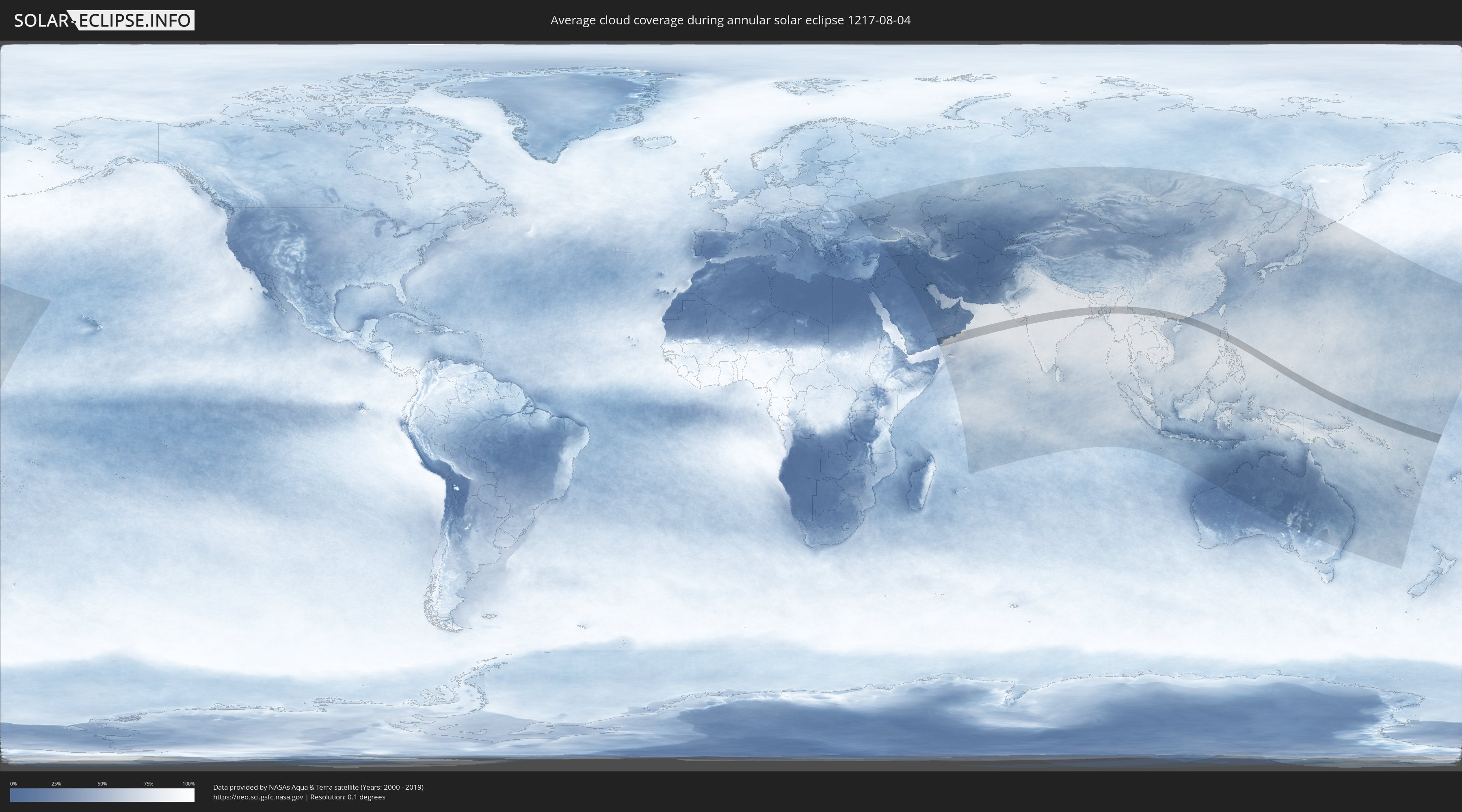
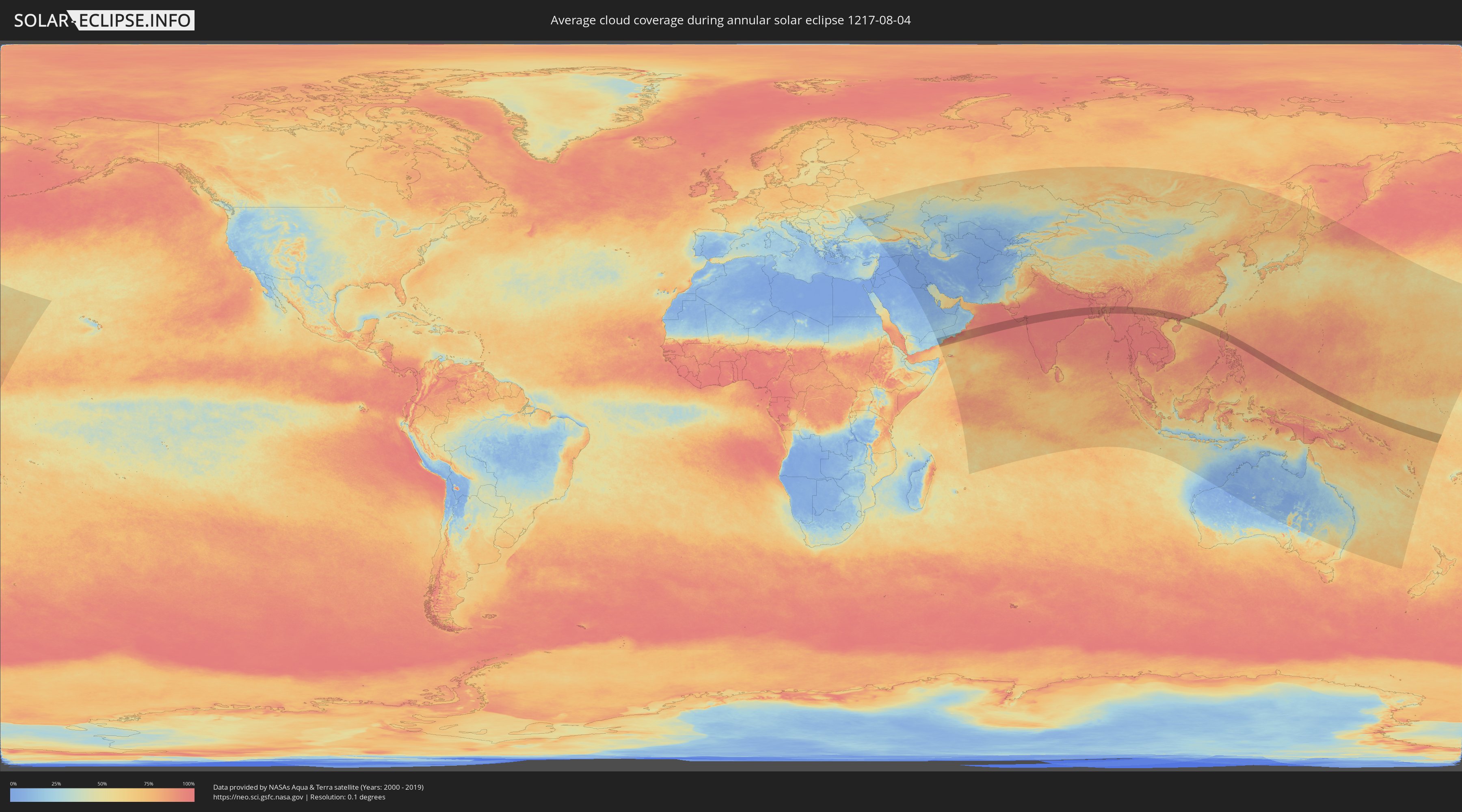
How will be the weather during the annular solar eclipse on 08/04/1217?
Where is the best place to see the annular solar eclipse of 08/04/1217?
The following maps show the average cloud coverage for the day of the annular solar eclipse.
With the help of these maps, it is possible to find the place along the eclipse path, which has the best
chance of a cloudless sky.
Nevertheless, you should consider local circumstances and inform about the weather of your chosen
observation site.
The data is provided by NASAs satellites
AQUA and TERRA.
The cloud maps are averaged over a period of 19 years (2000 - 2019).
Detailed country maps
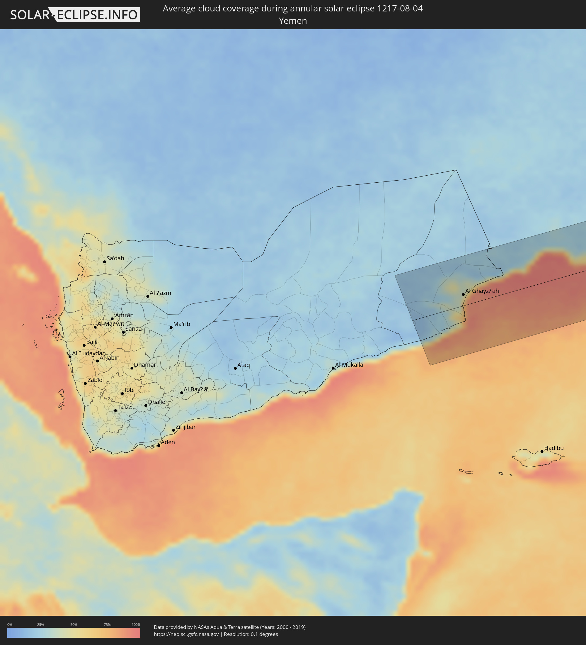 Yemen
Yemen
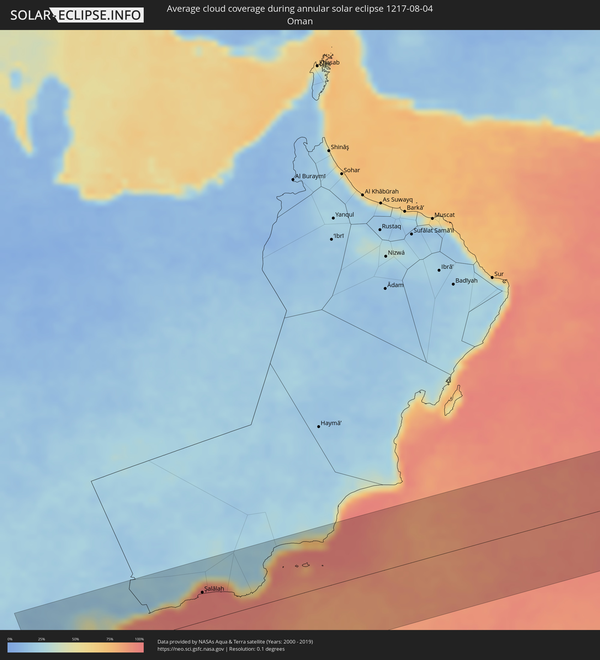 Oman
Oman
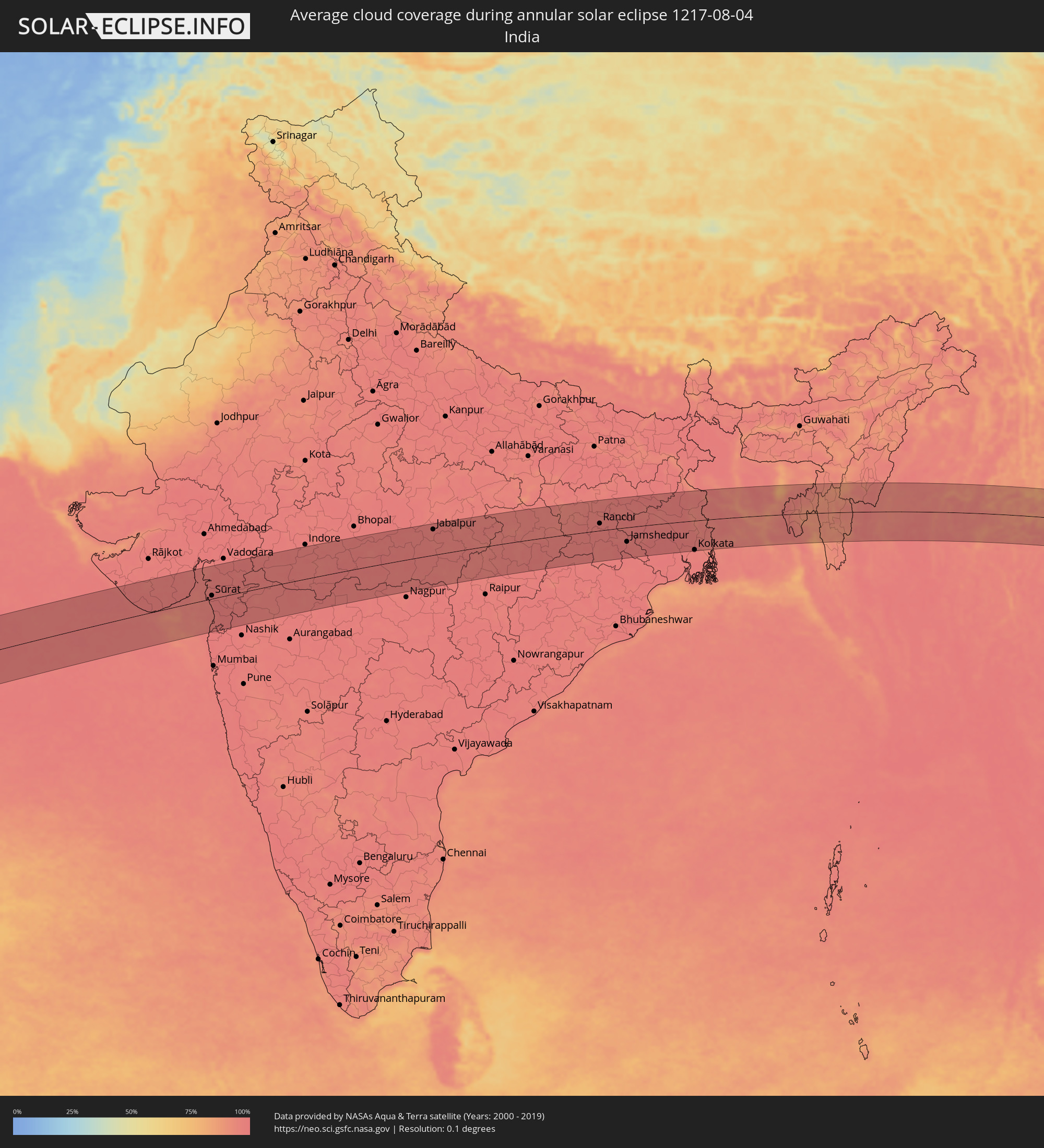 India
India
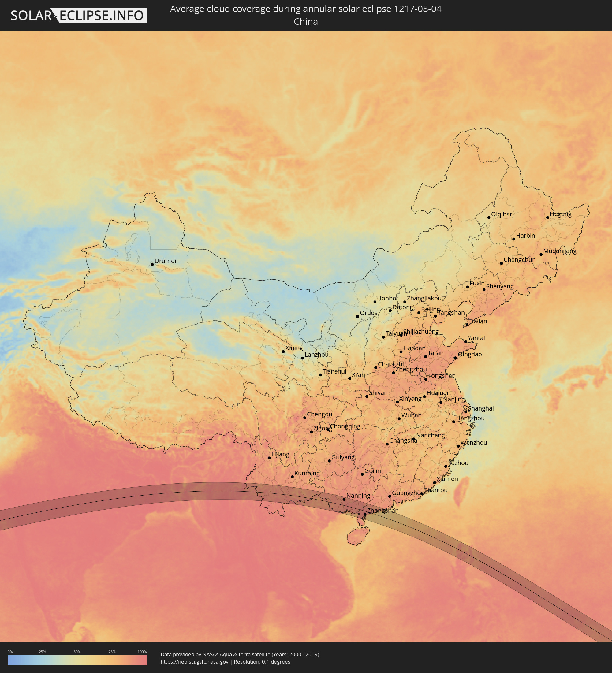 China
China
 Bangladesh
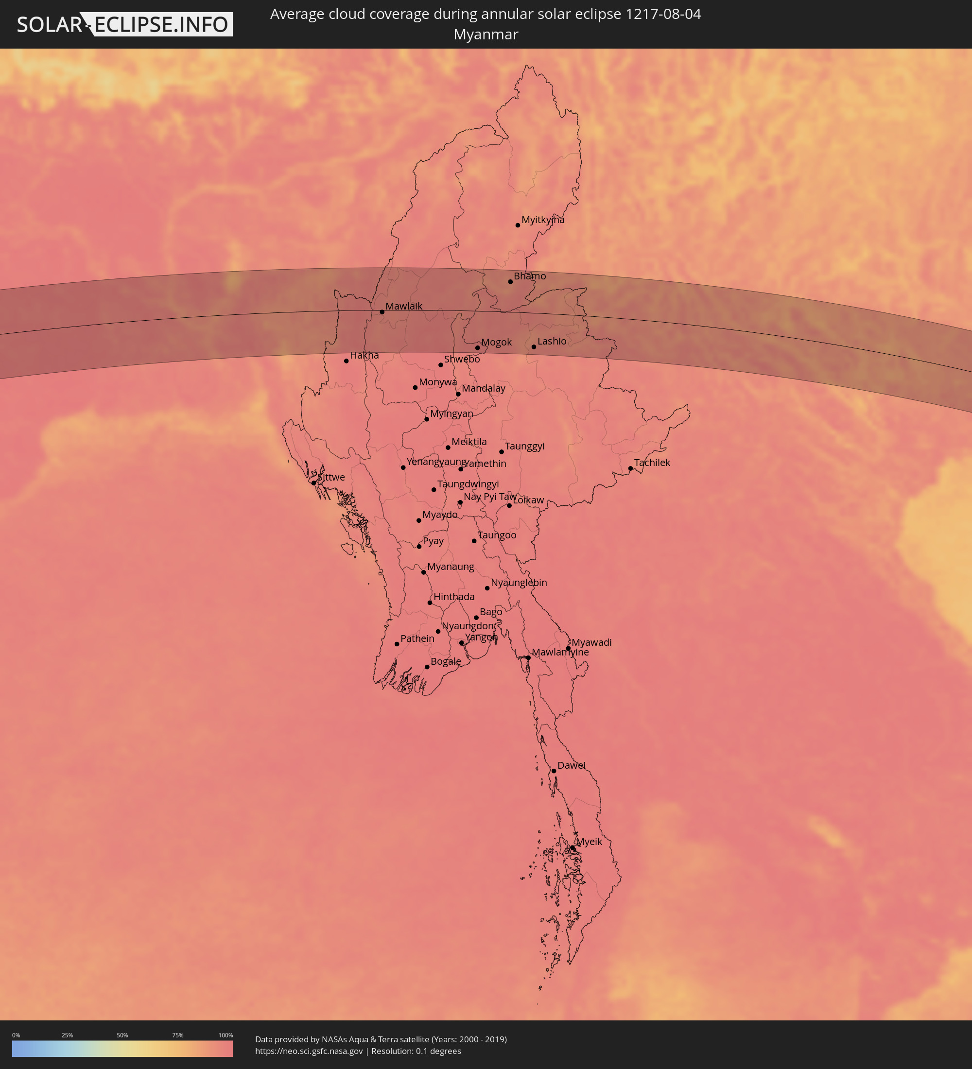 Myanmar
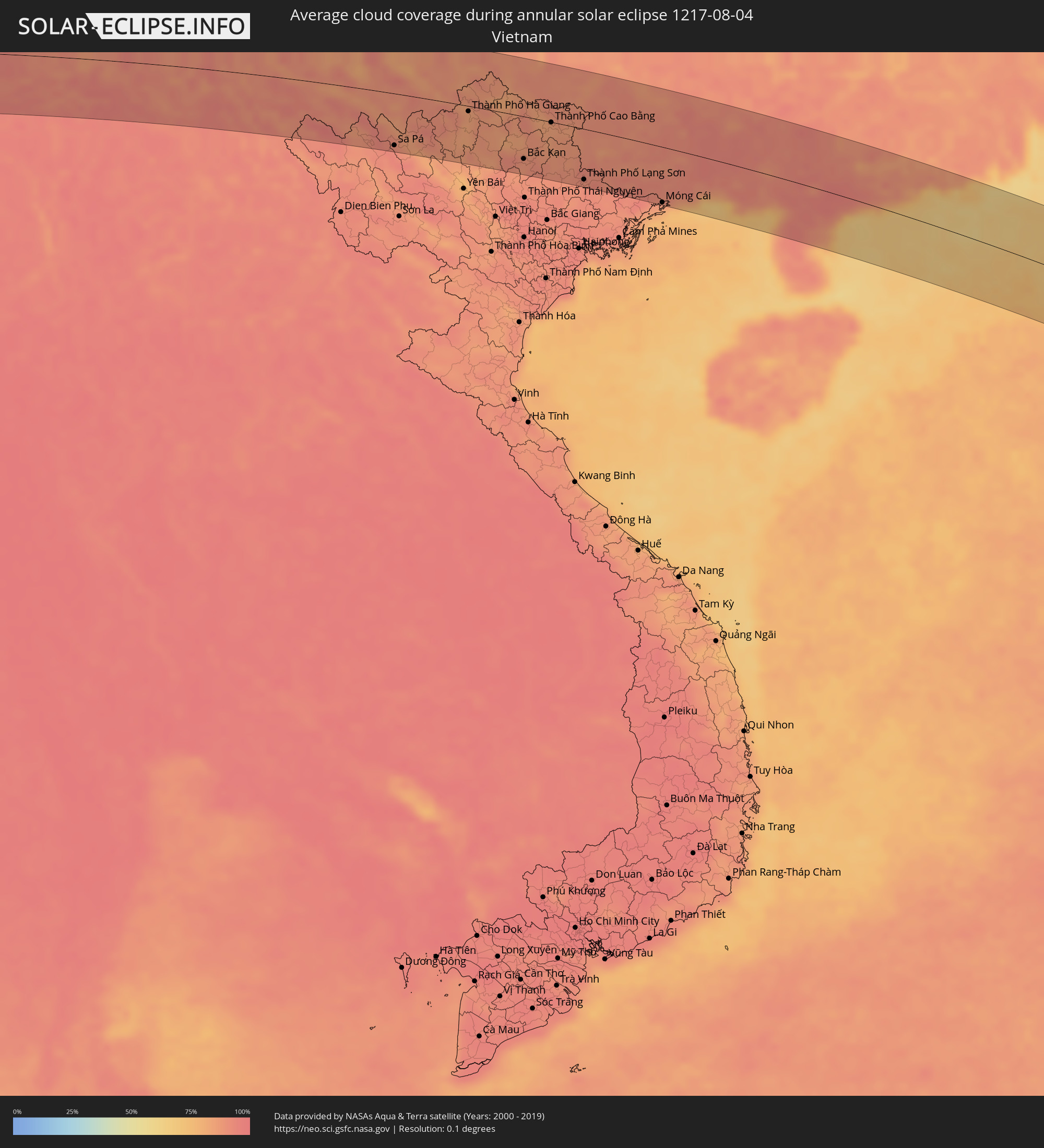 Vietnam
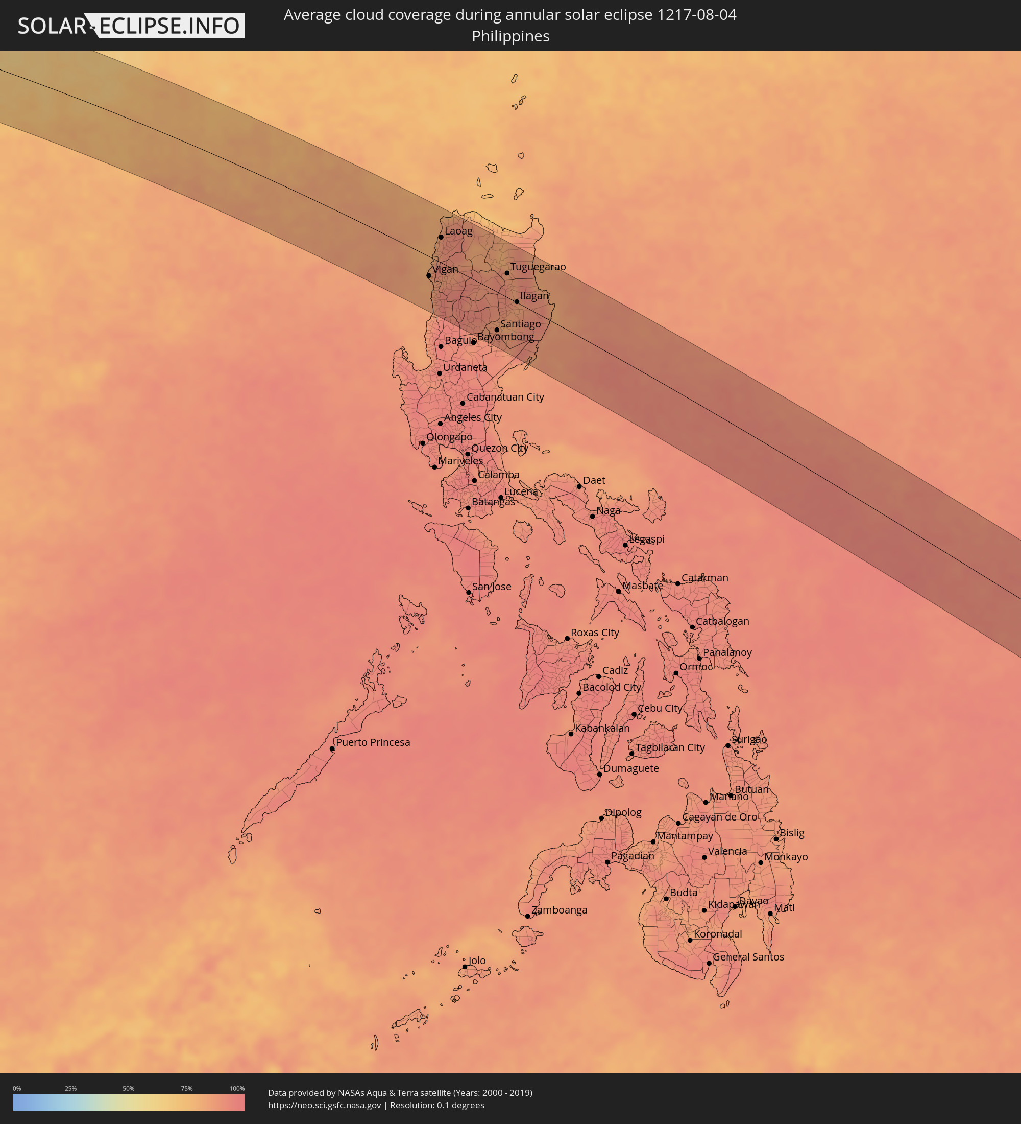 Philippines
Cities inside the path of the eclipse
The following table shows all locations with a population of more than 5,000 inside the eclipse path. Cities which have more than 100,000 inhabitants are marked bold. A click at the locations opens a detailed map.
| City | Type | Eclipse duration | Local time of max. eclipse | Distance to central line | Ø Cloud coverage |
|
Al Ghayz̧ah, Al Mahrah
|
annular | - | 05:29:17 UTC+03:06 | 26 km | 59% |
|
Şalālah, Z̧ufār
|
annular | - | 06:03:54 UTC+03:41 | 56 km | 96% |
|
Bhāvnagar, Gujarat
|
annular | - | 07:53:14 UTC+05:21 | 88 km | 97% |
|
Sūrat, Gujarat
|
annular | - | 07:53:27 UTC+05:21 | 10 km | 97% |
|
Bilimora, Gujarat
|
annular | - | 07:53:19 UTC+05:21 | 39 km | 97% |
|
Mālegaon, Maharashtra
|
annular | - | 07:54:38 UTC+05:21 | 98 km | 96% |
|
Dhūlia, Maharashtra
|
annular | - | 07:55:04 UTC+05:21 | 64 km | 96% |
|
Māndu, Madhya Pradesh
|
annular | - | 07:56:31 UTC+05:21 | 83 km | 98% |
|
Jalgaon, Maharashtra
|
annular | - | 07:55:55 UTC+05:21 | 70 km | 97% |
|
Burhānpur, Madhya Pradesh
|
annular | - | 07:56:46 UTC+05:21 | 50 km | 97% |
|
Punāsa, Madhya Pradesh
|
annular | - | 07:57:29 UTC+05:21 | 48 km | 97% |
|
Jabalpur, Madhya Pradesh
|
annular | - | 08:02:11 UTC+05:21 | 83 km | 97% |
|
Bilāspur, Chhattisgarh
|
annular | - | 08:04:36 UTC+05:21 | 72 km | 97% |
|
Korba, Chhattisgarh
|
annular | - | 08:05:32 UTC+05:21 | 51 km | 97% |
|
Ranchi, Jharkhand
|
annular | - | 08:10:08 UTC+05:21 | 23 km | 97% |
|
Bokāro, Jharkhand
|
annular | - | 08:11:26 UTC+05:21 | 65 km | 96% |
|
Jamshedpur, Jharkhand
|
annular | - | 08:11:23 UTC+05:21 | 47 km | 97% |
|
Dhanbād, Jharkhand
|
annular | - | 08:12:17 UTC+05:21 | 61 km | 95% |
|
Kulti, West Bengal
|
annular | - | 08:12:57 UTC+05:21 | 49 km | 96% |
|
Āsansol, West Bengal
|
annular | - | 08:13:10 UTC+05:21 | 42 km | 97% |
|
Durgapur, West Bengal
|
annular | - | 08:13:41 UTC+05:21 | 20 km | 96% |
|
Barddhamān, West Bengal
|
annular | - | 08:14:34 UTC+05:21 | 14 km | 97% |
|
Kolkata, West Bengal
|
annular | - | 08:15:15 UTC+05:21 | 96 km | 96% |
|
Bhātpāra, West Bengal
|
annular | - | 08:15:27 UTC+05:21 | 62 km | 96% |
|
Bārāsat, West Bengal
|
annular | - | 08:15:33 UTC+05:21 | 79 km | 96% |
|
Ishurdi, Rājshāhi
|
annular | - | 08:49:22 UTC+05:53 | 72 km | 95% |
|
Sātkhira, Khulna
|
annular | - | 08:48:51 UTC+05:53 | 86 km | 93% |
|
Kushtia, Khulna
|
annular | - | 08:49:23 UTC+05:53 | 46 km | 97% |
|
Jessore, Khulna
|
annular | - | 08:49:18 UTC+05:53 | 36 km | 97% |
|
Pābna, Rājshāhi
|
annular | - | 08:49:39 UTC+05:53 | 57 km | 93% |
|
Khulna, Khulna
|
annular | - | 08:49:52 UTC+05:53 | 78 km | 97% |
|
Shāhzādpur, Rājshāhi
|
annular | - | 08:50:25 UTC+05:53 | 73 km | 91% |
|
Farīdpur, Dhaka
|
annular | - | 08:50:41 UTC+05:53 | 8 km | 96% |
|
Nāgarpur, Dhaka
|
annular | - | 08:50:56 UTC+05:53 | 58 km | 94% |
|
Tungipāra, Dhaka
|
annular | - | 08:50:35 UTC+05:53 | 71 km | 95% |
|
Tāngāil, Dhaka
|
annular | - | 08:51:04 UTC+05:53 | 79 km | 94% |
|
Mādārīpur, Dhaka
|
annular | - | 08:51:17 UTC+05:53 | 43 km | 94% |
|
Pālang, Dhaka
|
annular | - | 08:51:36 UTC+05:53 | 38 km | 91% |
|
Barisāl, Barisāl
|
annular | - | 08:51:28 UTC+05:53 | 95 km | 94% |
|
Tungi, Dhaka
|
annular | - | 08:51:55 UTC+05:53 | 36 km | 96% |
|
Dhaka, Dhaka
|
annular | - | 08:51:52 UTC+05:53 | 16 km | 92% |
|
Narsingdi, Dhaka
|
annular | - | 08:52:35 UTC+05:53 | 38 km | 90% |
|
Rāipur, Chittagong
|
annular | - | 08:52:24 UTC+05:53 | 61 km | 96% |
|
Kishorganj, Dhaka
|
annular | - | 08:52:53 UTC+05:53 | 95 km | 93% |
|
Bhairab Bāzār, Dhaka
|
annular | - | 08:53:09 UTC+05:53 | 51 km | 91% |
|
Lākshām, Chittagong
|
annular | - | 08:53:12 UTC+05:53 | 40 km | 95% |
|
Comilla, Chittagong
|
annular | - | 08:53:24 UTC+05:53 | 16 km | 98% |
|
Agartala, Tripura
|
annular | - | 08:21:33 UTC+05:21 | 25 km | 96% |
|
Feni, Chittagong
|
annular | - | 08:53:44 UTC+05:53 | 67 km | 96% |
|
Habiganj, Sylhet
|
annular | - | 08:54:10 UTC+05:53 | 85 km | 94% |
|
Maulavi Bāzār, Sylhet
|
annular | - | 08:54:57 UTC+05:53 | 95 km | 96% |
|
Aizawl, Mizoram
|
annular | - | 08:24:37 UTC+05:21 | 7 km | 88% |
|
Falam, Chin
|
annular | - | 09:30:15 UTC+06:24 | 86 km | 96% |
|
Mawlaik, Sagain
|
annular | - | 09:32:04 UTC+06:24 | 6 km | 93% |
|
Mogok, Mandalay
|
annular | - | 09:37:10 UTC+06:24 | 84 km | 96% |
|
Bhamo, Kachin
|
annular | - | 09:39:02 UTC+06:24 | 66 km | 89% |
|
Lashio, Shan
|
annular | - | 09:40:23 UTC+06:24 | 78 km | 94% |
|
Gejiu, Yunnan
|
annular | - | 11:30:41 UTC+08:00 | 21 km | 90% |
|
Kaiyuan, Yunnan
|
annular | - | 11:31:00 UTC+08:00 | 60 km | 83% |
|
Lai Châu, Lai Châu
|
annular | - | 10:38:40 UTC+07:06 | 81 km | 91% |
|
Sa Pá, Lào Cai
|
annular | - | 10:39:52 UTC+07:06 | 81 km | 94% |
|
Lào Cai, Lào Cai
|
annular | - | 10:40:11 UTC+07:06 | 63 km | 85% |
|
Wenshan City, Yunnan
|
annular | - | 11:33:57 UTC+08:00 | 38 km | 84% |
|
Kaihua, Yunnan
|
annular | - | 11:34:02 UTC+08:00 | 39 km | 84% |
|
Mabai, Yunnan
|
annular | - | 11:34:44 UTC+08:00 | 3 km | 91% |
|
Thành Phố Hà Giang, Hà Giang
|
annular | - | 10:43:08 UTC+07:06 | 8 km | 83% |
|
Bắc Kạn, Bắc Kạn
|
annular | - | 10:46:11 UTC+07:06 | 66 km | 87% |
|
Thành Phố Cao Bằng, Cao Bằng
|
annular | - | 10:47:11 UTC+07:06 | 1 km | 85% |
|
Thành Phố Lạng Sơn, Lạng Sơn
|
annular | - | 10:49:20 UTC+07:06 | 78 km | 90% |
|
Baihe, Guangxi Zhuang Autonomous Region
|
annular | - | 11:43:59 UTC+08:00 | 37 km | 89% |
|
Móng Cái, Quảng Ninh
|
annular | - | 10:53:30 UTC+07:06 | 86 km | 81% |
|
Nanning, Guangxi Zhuang Autonomous Region
|
annular | - | 11:46:55 UTC+08:00 | 63 km | 94% |
|
Pumiao, Guangxi Zhuang Autonomous Region
|
annular | - | 11:47:30 UTC+08:00 | 60 km | 92% |
|
Qinzhou, Guangxi Zhuang Autonomous Region
|
annular | - | 11:48:37 UTC+08:00 | 21 km | 94% |
|
Beihai, Guangxi Zhuang Autonomous Region
|
annular | - | 11:50:36 UTC+08:00 | 61 km | 82% |
|
Lianzhou, Guangxi Zhuang Autonomous Region
|
annular | - | 11:50:46 UTC+08:00 | 38 km | 93% |
|
Yashan, Guangxi Zhuang Autonomous Region
|
annular | - | 11:52:42 UTC+08:00 | 39 km | 93% |
|
Lianjiang, Guangdong
|
annular | - | 11:54:20 UTC+08:00 | 10 km | 95% |
|
Zhanjiang, Guangdong
|
annular | - | 11:54:55 UTC+08:00 | 47 km | 93% |
|
Zhongshan, Guangdong
|
annular | - | 11:55:38 UTC+08:00 | 36 km | 85% |
|
Huazhou, Guangdong
|
annular | - | 11:55:21 UTC+08:00 | 3 km | 95% |
|
Wuchuan, Guangdong
|
annular | - | 11:56:08 UTC+08:00 | 16 km | 89% |
|
Gaozhou, Guangdong
|
annular | - | 11:55:54 UTC+08:00 | 38 km | 94% |
|
Xinyi, Guangdong
|
annular | - | 11:55:47 UTC+08:00 | 87 km | 88% |
|
Tangping, Guangdong
|
annular | - | 11:59:22 UTC+08:00 | 82 km | 88% |
|
Yangjiang, Guangdong
|
annular | - | 11:59:39 UTC+08:00 | 64 km | 87% |
|
Vigan, Ilocos
|
annular | - | 12:33:31 UTC+08:00 | 31 km | 83% |
|
Candon, Ilocos
|
annular | - | 12:34:23 UTC+08:00 | 66 km | 89% |
|
Cabugao, Ilocos
|
annular | - | 12:33:22 UTC+08:00 | 6 km | 92% |
|
Suyo, Ilocos
|
annular | - | 12:35:00 UTC+08:00 | 84 km | 88% |
|
Batac City, Ilocos
|
annular | - | 12:33:16 UTC+08:00 | 25 km | 89% |
|
Laoag, Ilocos
|
annular | - | 12:33:07 UTC+08:00 | 40 km | 88% |
|
Dingras, Ilocos
|
annular | - | 12:33:36 UTC+08:00 | 36 km | 91% |
|
Mankayan, Cordillera
|
annular | - | 12:36:01 UTC+08:00 | 82 km | 92% |
|
Bontoc, Cordillera
|
annular | - | 12:36:15 UTC+08:00 | 51 km | 91% |
|
Pasil, Cordillera
|
annular | - | 12:36:13 UTC+08:00 | 14 km | 89% |
|
Diadi, Cagayan Valley
|
annular | - | 12:38:05 UTC+08:00 | 67 km | 89% |
|
Tabuk, Cordillera
|
annular | - | 12:37:06 UTC+08:00 | 12 km | 91% |
|
Santiago, Cagayan Valley
|
annular | - | 12:38:45 UTC+08:00 | 62 km | 90% |
|
Saguday, Cagayan Valley
|
annular | - | 12:39:03 UTC+08:00 | 75 km | 89% |
|
San Mateo, Cagayan Valley
|
annular | - | 12:38:31 UTC+08:00 | 41 km | 83% |
|
Quezon, Cagayan Valley
|
annular | - | 12:37:49 UTC+08:00 | 3 km | 90% |
|
Roxas, Cagayan Valley
|
annular | - | 12:38:12 UTC+08:00 | 16 km | 89% |
|
Magapit, Aguiguican, Cagayan Valley
|
annular | - | 12:36:38 UTC+08:00 | 84 km | 83% |
|
Maddela, Cagayan Valley
|
annular | - | 12:39:47 UTC+08:00 | 89 km | 88% |
|
Alicia, Cagayan Valley
|
annular | - | 12:39:03 UTC+08:00 | 45 km | 82% |
|
Tuguegarao, Cagayan Valley
|
annular | - | 12:37:39 UTC+08:00 | 38 km | 86% |
|
Cabagan, Cagayan Valley
|
annular | - | 12:38:07 UTC+08:00 | 22 km | 84% |
|
Naguilian, Cagayan Valley
|
annular | - | 12:39:03 UTC+08:00 | 14 km | 85% |
|
Ilagan, Cagayan Valley
|
annular | - | 12:38:59 UTC+08:00 | 1 km | 83% |
|
San Mariano, Cagayan Valley
|
annular | - | 12:39:40 UTC+08:00 | 9 km | 89% |