Total solar eclipse of 05/03/1231
| Day of week: | Saturday |
| Maximum duration of eclipse: | 02m11s |
| Maximum width of eclipse path: | 78 km |
| Saros cycle: | 106 |
| Coverage: | 100% |
| Magnitude: | 1.0224 |
| Gamma: | 0.1763 |
Wo kann man die Sonnenfinsternis vom 05/03/1231 sehen?
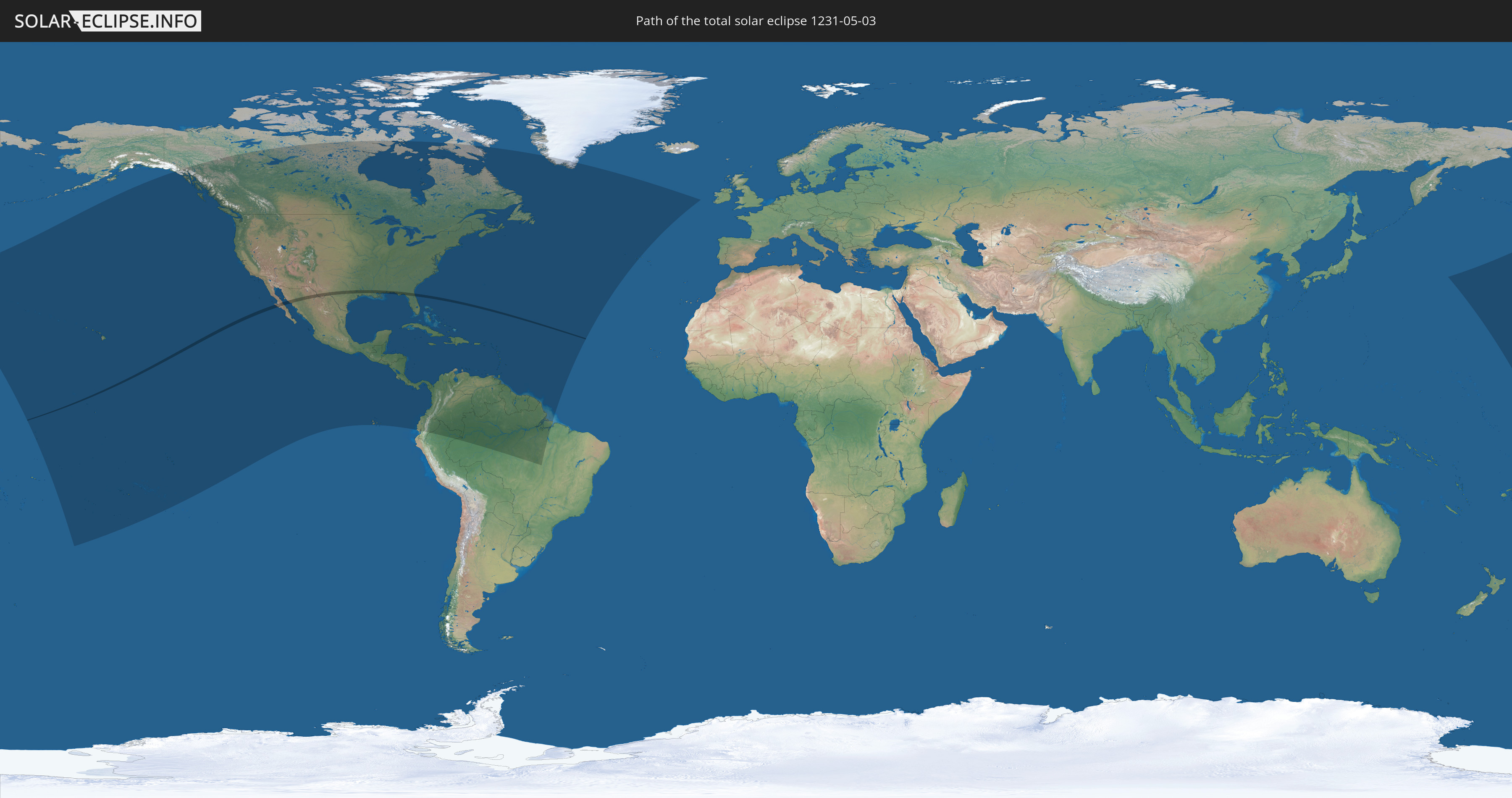
Die Sonnenfinsternis am 05/03/1231 kann man in 51 Ländern als partielle Sonnenfinsternis beobachten.
Der Finsternispfad verläuft durch 3 Länder. Nur in diesen Ländern ist sie als total Sonnenfinsternis zu sehen.
In den folgenden Ländern ist die Sonnenfinsternis total zu sehen
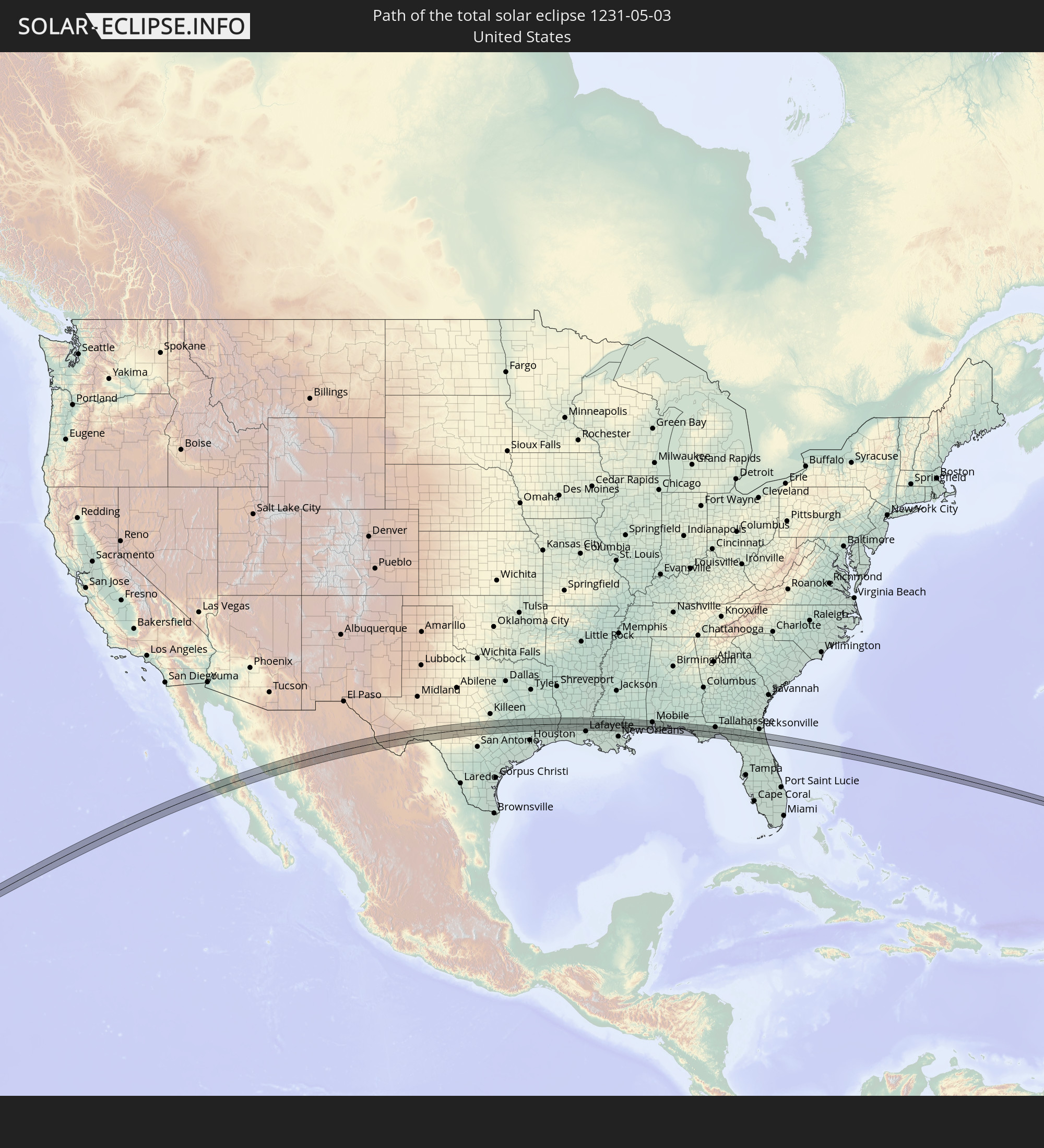 United States
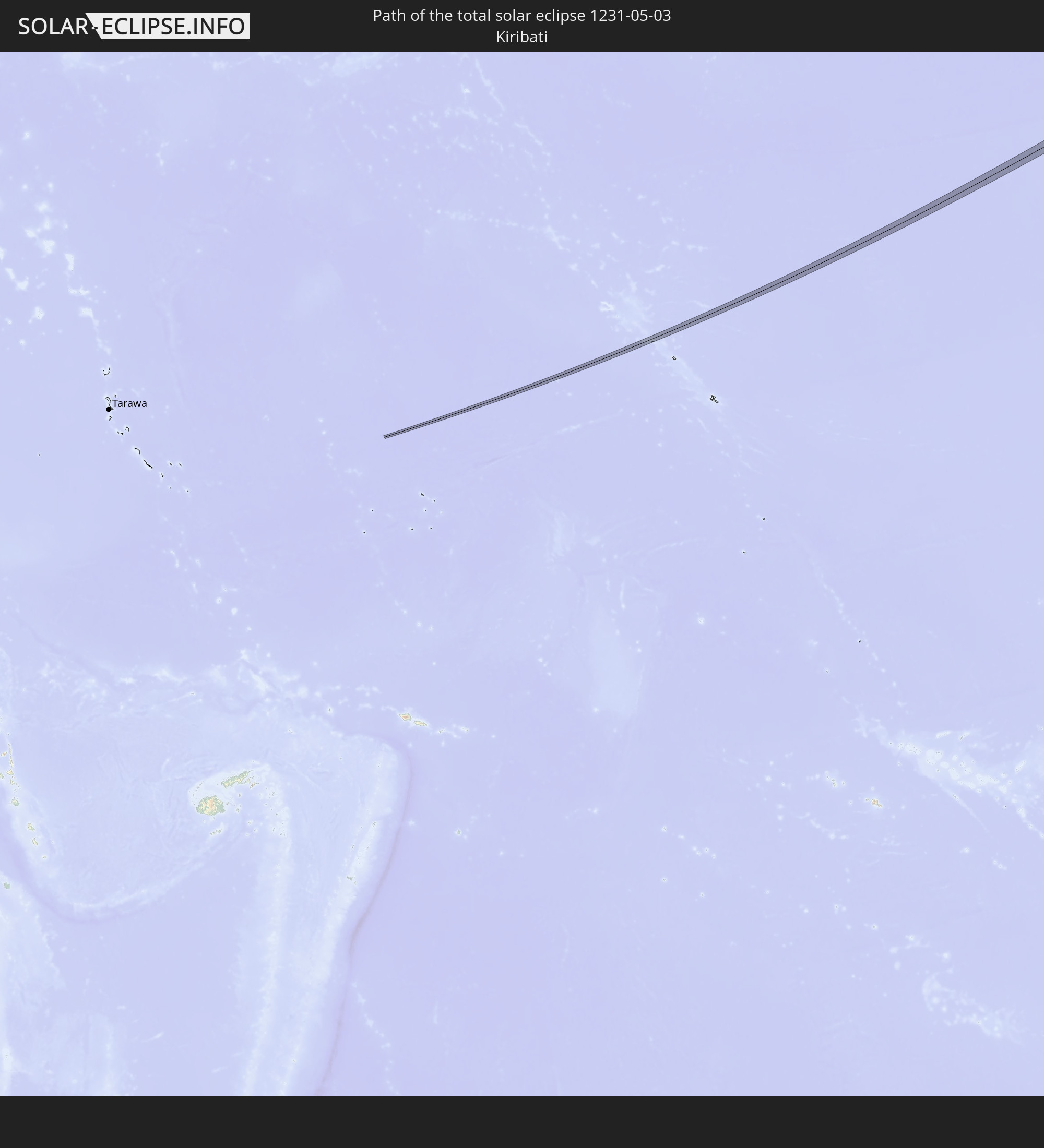 Kiribati
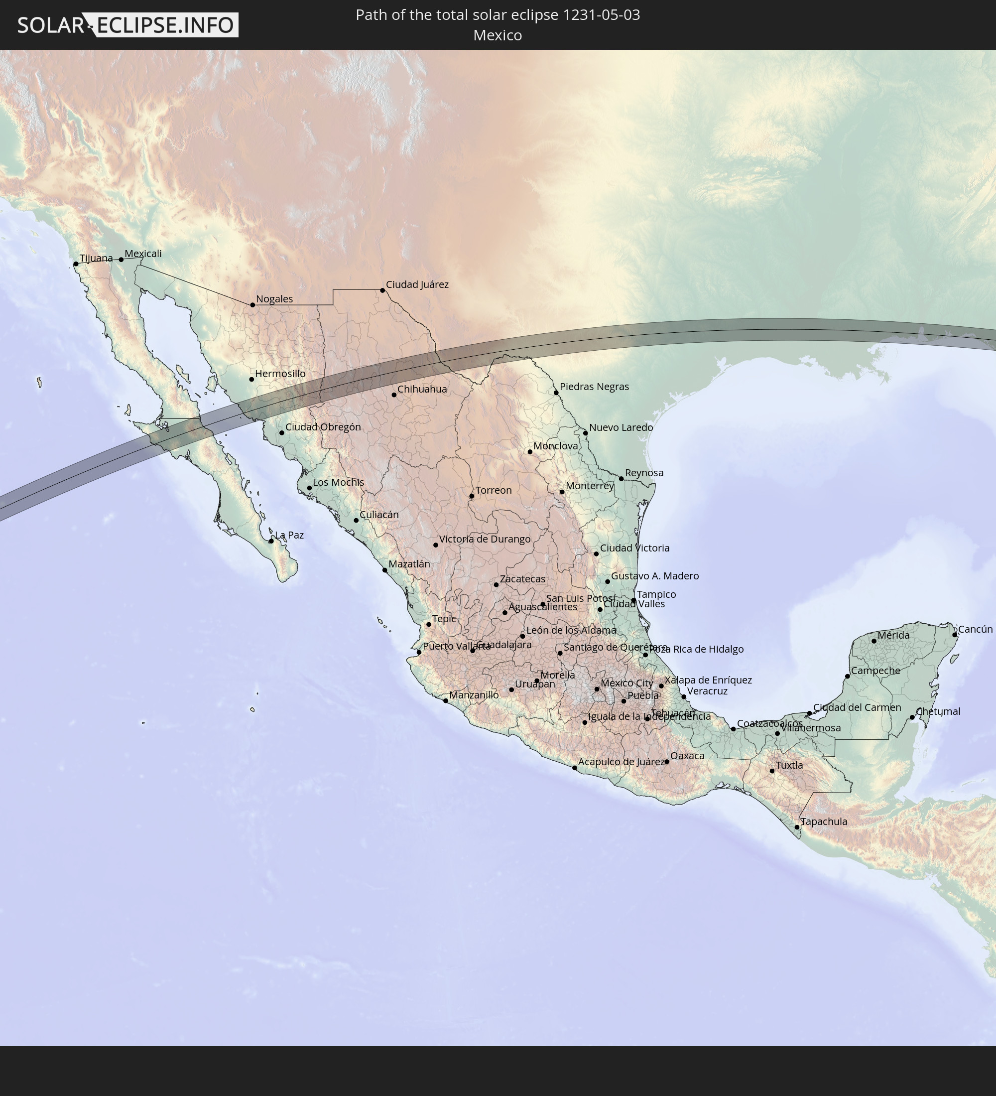 Mexico
In den folgenden Ländern ist die Sonnenfinsternis partiell zu sehen
 United States
 United States Minor Outlying Islands
 Kiribati
 Cook Islands
 French Polynesia
 Canada
 Mexico
 Greenland
 Guatemala
 Ecuador
 El Salvador
 Honduras
 Belize
 Nicaragua
 Costa Rica
 Cuba
Cuba
 Panama
 Colombia
 Cayman Islands
 Peru
Peru
 The Bahamas
 Jamaica
 Haiti
Haiti
 Brazil
 Venezuela
 Turks and Caicos Islands
 Dominican Republic
 Aruba
Aruba
 Puerto Rico
 United States Virgin Islands
 Bermuda
 British Virgin Islands
 Anguilla
 Collectivity of Saint Martin
 Saint Barthélemy
 Saint Kitts and Nevis
 Antigua and Barbuda
 Montserrat
 Trinidad and Tobago
 Guadeloupe
 Grenada
 Dominica
 Saint Vincent and the Grenadines
 Guyana
 Martinique
 Saint Lucia
 Barbados
 Suriname
 Saint Pierre and Miquelon
 French Guiana
 Portugal
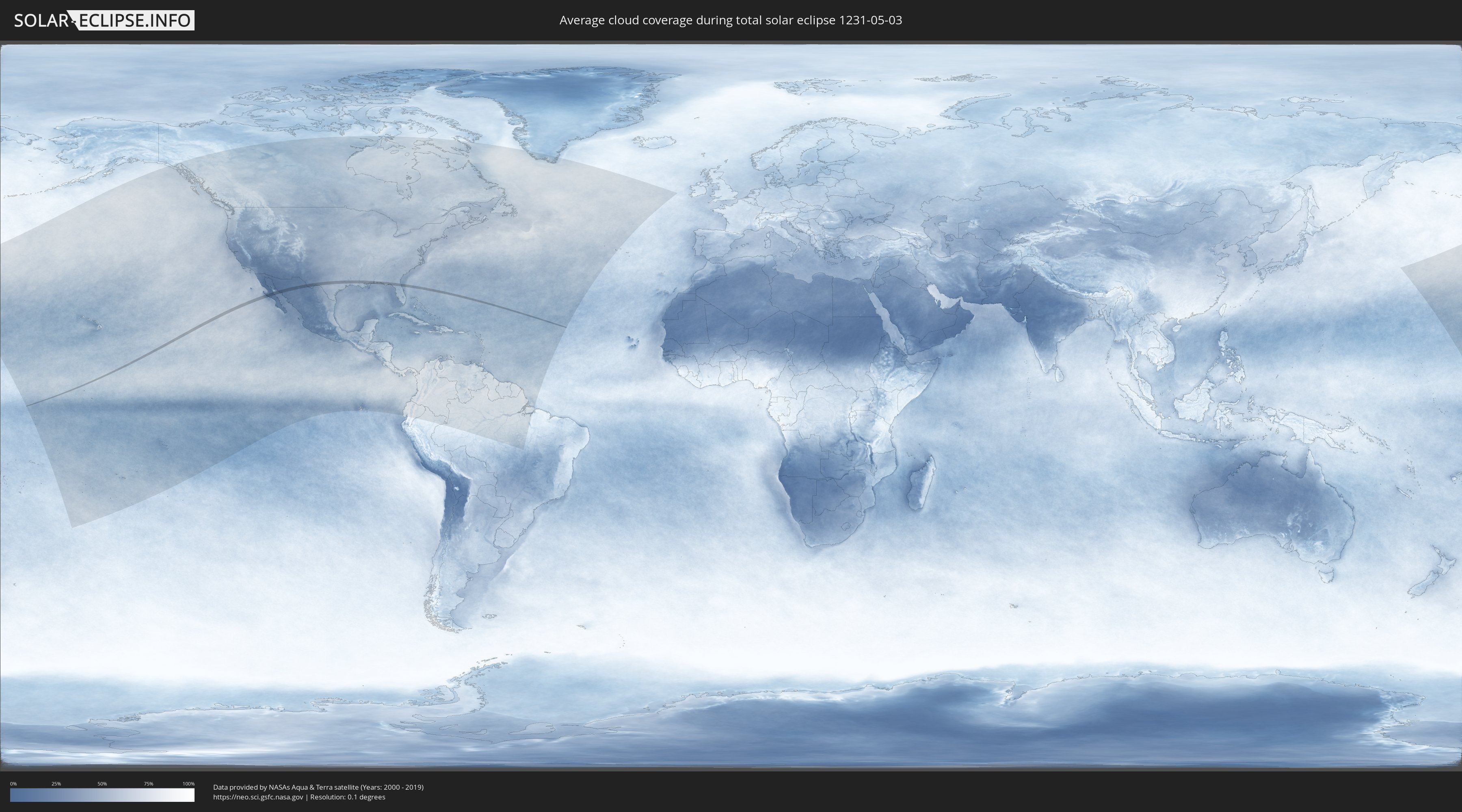
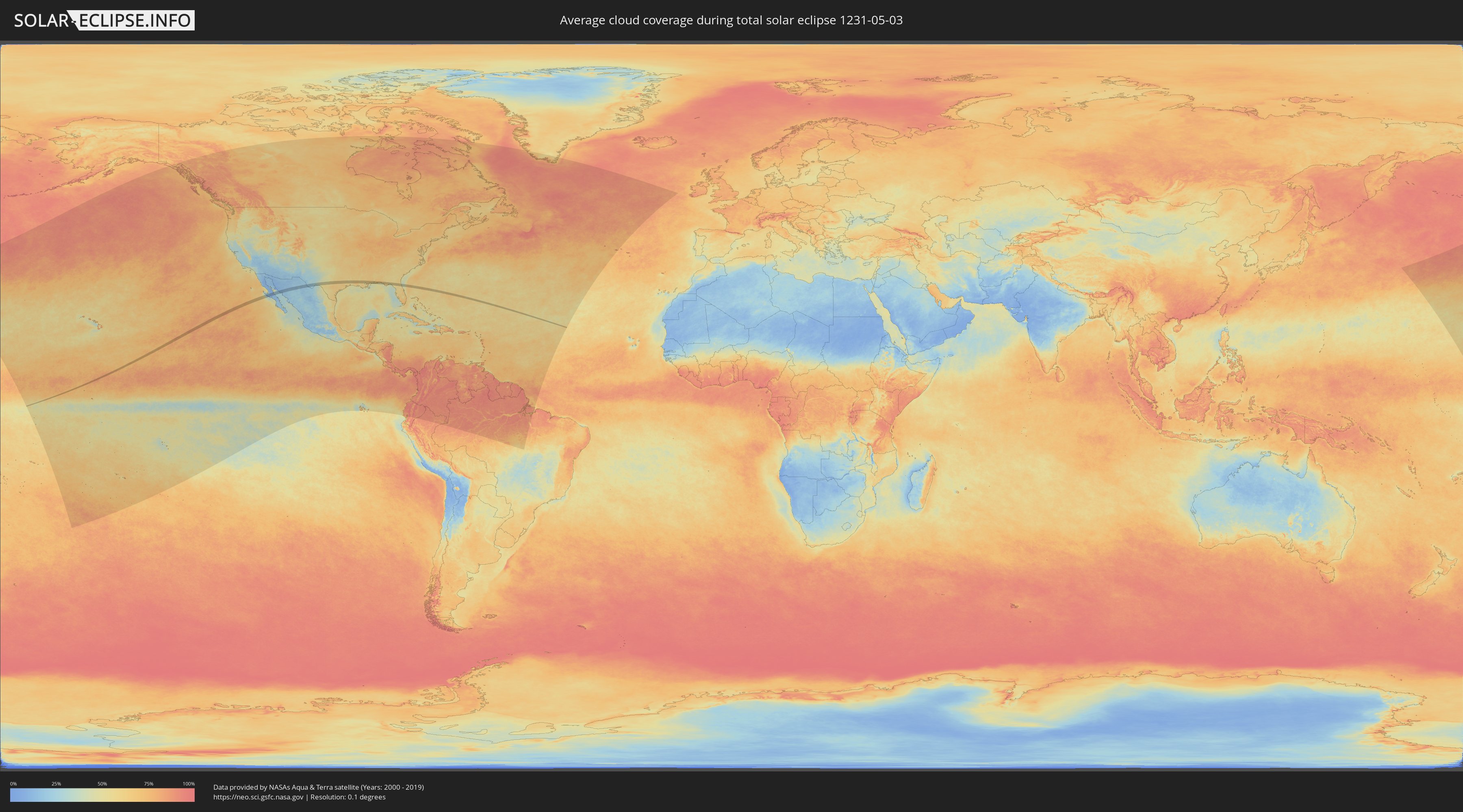
How will be the weather during the total solar eclipse on 05/03/1231?
Where is the best place to see the total solar eclipse of 05/03/1231?
The following maps show the average cloud coverage for the day of the total solar eclipse.
With the help of these maps, it is possible to find the place along the eclipse path, which has the best
chance of a cloudless sky.
Nevertheless, you should consider local circumstances and inform about the weather of your chosen
observation site.
The data is provided by NASAs satellites
AQUA and TERRA.
The cloud maps are averaged over a period of 19 years (2000 - 2019).
Detailed country maps
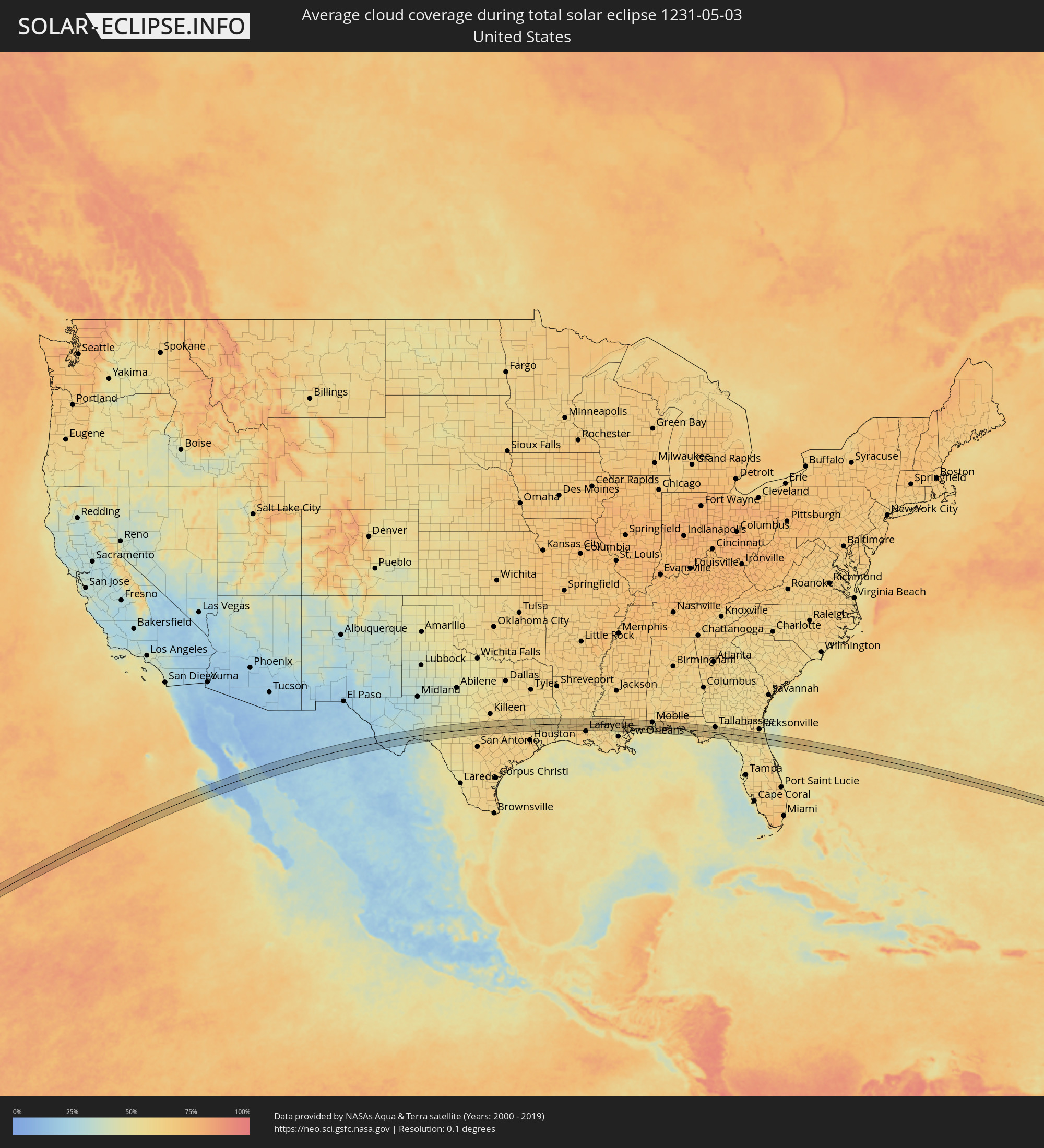 United States
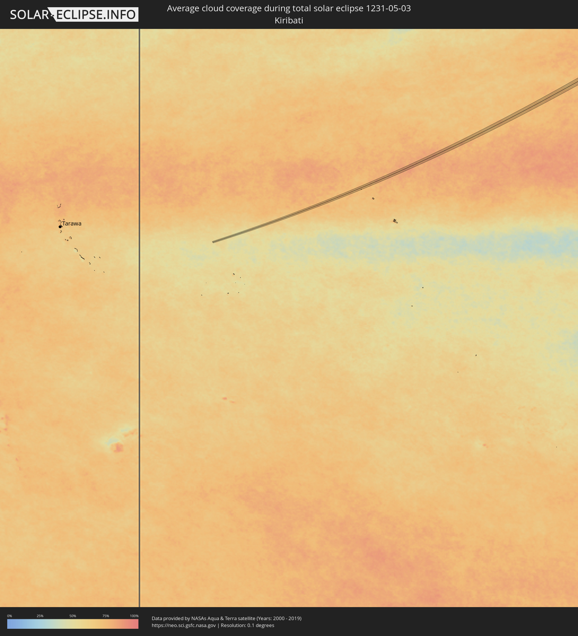 Kiribati
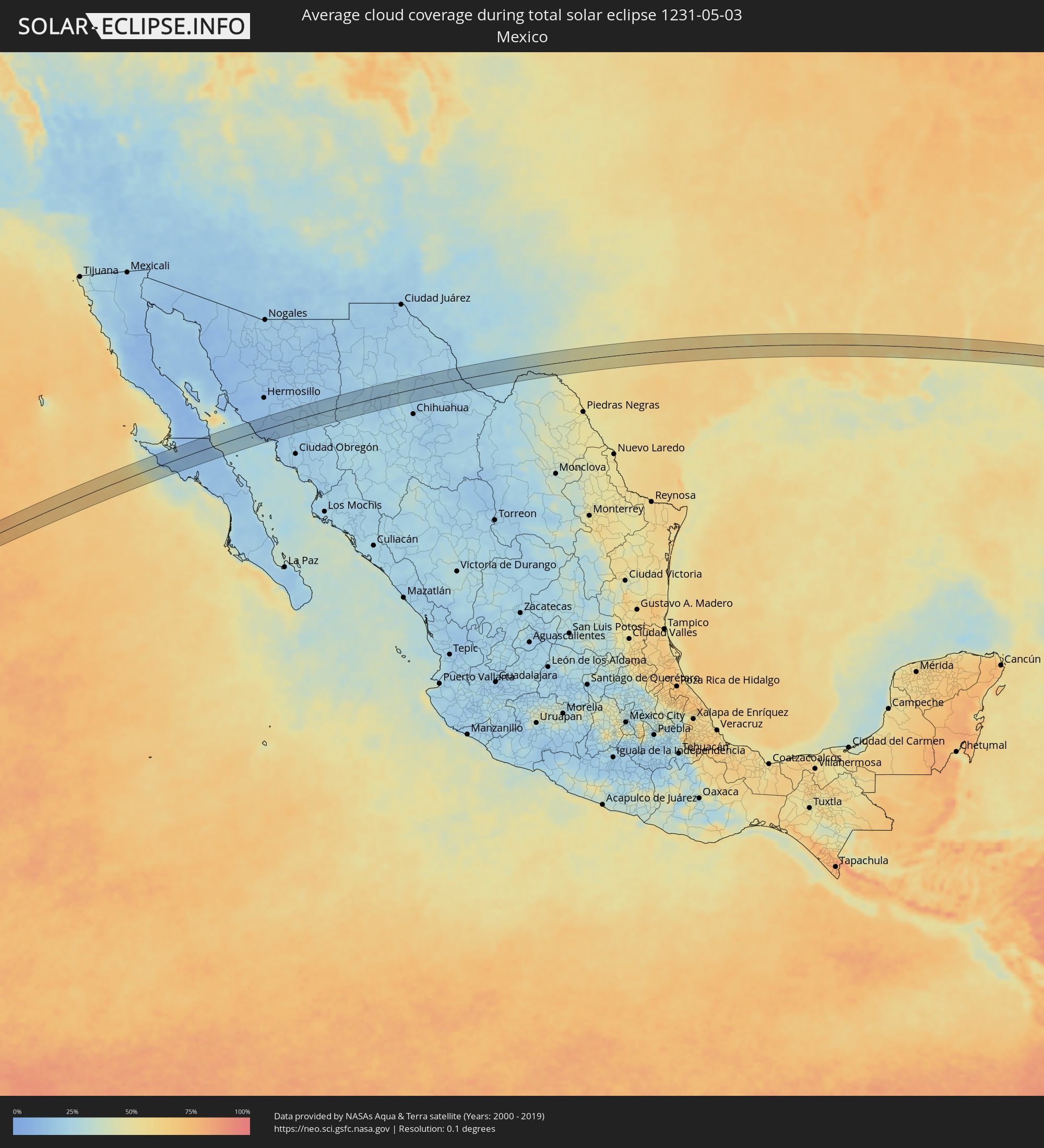 Mexico
Cities inside the path of the eclipse
The following table shows all locations with a population of more than 5,000 inside the eclipse path. Cities which have more than 100,000 inhabitants are marked bold. A click at the locations opens a detailed map.
| City | Type | Eclipse duration | Local time of max. eclipse | Distance to central line | Ø Cloud coverage |
|
Villa Alberto Andrés Alvarado Arámburo, Baja California Sur
|
total | - | 12:07:36 UTC-07:05 | 18 km | 13% |
|
Heroica Guaymas, Sonora
|
total | - | 11:56:21 UTC-07:23 | 31 km | 26% |
|
Empalme, Sonora
|
total | - | 11:56:37 UTC-07:23 | 29 km | 18% |
|
San Pedro Madera, Chihuahua
|
total | - | 12:23:01 UTC-07:05 | 30 km | 18% |
|
Ojinaga, Chihuahua
|
total | - | 12:32:52 UTC-07:05 | 8 km | 21% |
|
Manuel Ojinaga, Chihuahua
|
total | - | 12:33:13 UTC-07:05 | 10 km | 20% |
|
Kerrville, Texas
|
total | - | 13:52:43 UTC-06:00 | 32 km | 54% |
|
Fredericksburg, Texas
|
total | - | 13:53:25 UTC-06:00 | 9 km | 54% |
|
Lakeway, Texas
|
total | - | 13:55:38 UTC-06:00 | 7 km | 58% |
|
Leander, Texas
|
total | - | 13:55:57 UTC-06:00 | 16 km | 59% |
|
Anderson Mill, Texas
|
total | - | 13:56:04 UTC-06:00 | 2 km | 59% |
|
Austin, Texas
|
total | - | 13:56:13 UTC-06:00 | 20 km | 62% |
|
Wells Branch, Texas
|
total | - | 13:56:22 UTC-06:00 | 0 km | 62% |
|
Round Rock, Texas
|
total | - | 13:56:23 UTC-06:00 | 6 km | 62% |
|
Hornsby Bend, Texas
|
total | - | 13:56:36 UTC-06:00 | 23 km | 61% |
|
Hutto, Texas
|
total | - | 13:56:42 UTC-06:00 | 9 km | 62% |
|
Taylor, Texas
|
total | - | 13:57:02 UTC-06:00 | 11 km | 58% |
|
Elgin, Texas
|
total | - | 13:57:08 UTC-06:00 | 13 km | 63% |
|
Camp Swift, Texas
|
total | - | 13:57:19 UTC-06:00 | 32 km | 62% |
|
College Station, Texas
|
total | - | 13:59:37 UTC-06:00 | 11 km | 61% |
|
Navasota, Texas
|
total | - | 14:00:13 UTC-06:00 | 17 km | 63% |
|
Huntsville, Texas
|
total | - | 14:01:28 UTC-06:00 | 18 km | 56% |
|
Conroe, Texas
|
total | - | 14:01:44 UTC-06:00 | 28 km | 60% |
|
Cleveland, Texas
|
total | - | 14:02:36 UTC-06:00 | 26 km | 59% |
|
West Livingston, Texas
|
total | - | 14:02:45 UTC-06:00 | 13 km | 55% |
|
Silsbee, Texas
|
total | - | 14:04:43 UTC-06:00 | 28 km | 59% |
|
Jasper, Texas
|
total | - | 14:05:01 UTC-06:00 | 35 km | 57% |
|
DeRidder, Louisiana
|
total | - | 14:06:38 UTC-06:00 | 26 km | 59% |
|
Moss Bluff, Louisiana
|
total | - | 14:06:59 UTC-06:00 | 35 km | 59% |
|
Oakdale, Louisiana
|
total | - | 14:08:02 UTC-06:00 | 22 km | 61% |
|
Oakdale, Louisiana
|
total | - | 14:08:08 UTC-06:00 | 21 km | 61% |
|
Eunice, Louisiana
|
total | - | 14:08:40 UTC-06:00 | 13 km | 64% |
|
Ville Platte, Louisiana
|
total | - | 14:08:56 UTC-06:00 | 8 km | 65% |
|
Opelousas, Louisiana
|
total | - | 14:09:24 UTC-06:00 | 9 km | 64% |
|
Carencro, Louisiana
|
total | - | 14:09:32 UTC-06:00 | 33 km | 63% |
|
Plaquemine, Louisiana
|
total | - | 14:11:19 UTC-06:00 | 35 km | 62% |
|
Baker, Louisiana
|
total | - | 14:11:22 UTC-06:00 | 1 km | 60% |
|
Zachary, Louisiana
|
total | - | 14:11:22 UTC-06:00 | 6 km | 60% |
|
Baton Rouge, Louisiana
|
total | - | 14:11:26 UTC-06:00 | 16 km | 62% |
|
Gardere, Louisiana
|
total | - | 14:11:30 UTC-06:00 | 28 km | 61% |
|
Merrydale, Louisiana
|
total | - | 14:11:31 UTC-06:00 | 11 km | 62% |
|
Oak Hills Place, Louisiana
|
total | - | 14:11:37 UTC-06:00 | 26 km | 61% |
|
Village Saint George, Louisiana
|
total | - | 14:11:39 UTC-06:00 | 26 km | 61% |
|
Central, Louisiana
|
total | - | 14:11:39 UTC-06:00 | 5 km | 60% |
|
Old Jefferson, Louisiana
|
total | - | 14:11:45 UTC-06:00 | 24 km | 63% |
|
Prairieville, Louisiana
|
total | - | 14:11:53 UTC-06:00 | 33 km | 63% |
|
Denham Springs, Louisiana
|
total | - | 14:11:51 UTC-06:00 | 12 km | 62% |
|
Hammond, Louisiana
|
total | - | 14:12:54 UTC-06:00 | 9 km | 58% |
|
Ponchatoula, Louisiana
|
total | - | 14:12:58 UTC-06:00 | 16 km | 50% |
|
Covington, Louisiana
|
total | - | 14:13:40 UTC-06:00 | 11 km | 59% |
|
Mandeville, Louisiana
|
total | - | 14:13:47 UTC-06:00 | 24 km | 52% |
|
Lacombe, Louisiana
|
total | - | 14:14:04 UTC-06:00 | 28 km | 54% |
|
Bogalusa, Louisiana
|
total | - | 14:14:04 UTC-06:00 | 25 km | 60% |
|
Slidell, Louisiana
|
total | - | 14:14:25 UTC-06:00 | 32 km | 58% |
|
Picayune, Mississippi
|
total | - | 14:14:32 UTC-06:00 | 3 km | 60% |
|
Carriere, Mississippi
|
total | - | 14:14:33 UTC-06:00 | 7 km | 62% |
|
Waveland, Mississippi
|
total | - | 14:15:15 UTC-06:00 | 29 km | 52% |
|
Diamondhead, Mississippi
|
total | - | 14:15:14 UTC-06:00 | 17 km | 56% |
|
Bay Saint Louis, Mississippi
|
total | - | 14:15:20 UTC-06:00 | 26 km | 50% |
|
Long Beach, Mississippi
|
total | - | 14:15:41 UTC-06:00 | 20 km | 56% |
|
West Gulfport, Mississippi
|
total | - | 14:15:47 UTC-06:00 | 14 km | 55% |
|
D'Iberville, Mississippi
|
total | - | 14:16:11 UTC-06:00 | 11 km | 53% |
|
Biloxi, Mississippi
|
total | - | 14:16:13 UTC-06:00 | 14 km | 53% |
|
Saint Martin, Mississippi
|
total | - | 14:16:14 UTC-06:00 | 9 km | 53% |
|
Gulf Hills, Mississippi
|
total | - | 14:16:17 UTC-06:00 | 10 km | 55% |
|
Pascagoula, Mississippi
|
total | - | 14:16:53 UTC-06:00 | 16 km | 56% |
|
Moss Point, Mississippi
|
total | - | 14:16:55 UTC-06:00 | 10 km | 54% |
|
Tillmans Corner, Alabama
|
total | - | 14:17:34 UTC-06:00 | 12 km | 60% |
|
Mobile, Alabama
|
total | - | 14:17:46 UTC-06:00 | 24 km | 54% |
|
Spanish Fort, Alabama
|
total | - | 14:18:02 UTC-06:00 | 23 km | 55% |
|
Daphne, Alabama
|
total | - | 14:18:05 UTC-06:00 | 15 km | 56% |
|
Gulf Shores, Alabama
|
total | - | 14:18:39 UTC-06:00 | 23 km | 50% |
|
Foley, Alabama
|
total | - | 14:18:37 UTC-06:00 | 6 km | 62% |
|
Cantonment, Florida
|
total | - | 14:19:11 UTC-06:00 | 19 km | 65% |
|
Gonzalez, Florida
|
total | - | 14:19:17 UTC-06:00 | 17 km | 65% |
|
Warrington, Florida
|
total | - | 14:19:25 UTC-06:00 | 5 km | 62% |
|
East Pensacola Heights, Florida
|
total | - | 14:19:35 UTC-06:00 | 1 km | 62% |
|
Pace, Florida
|
total | - | 14:19:32 UTC-06:00 | 20 km | 60% |
|
Milton, Florida
|
total | - | 14:19:45 UTC-06:00 | 24 km | 59% |
|
East Milton, Florida
|
total | - | 14:19:48 UTC-06:00 | 22 km | 59% |
|
Navarre, Florida
|
total | - | 14:20:12 UTC-06:00 | 0 km | 58% |
|
Wright, Florida
|
total | - | 14:20:37 UTC-06:00 | 8 km | 59% |
|
Lake Lorraine, Florida
|
total | - | 14:20:45 UTC-06:00 | 7 km | 54% |
|
Eglin Village, Florida
|
total | - | 14:20:48 UTC-06:00 | 9 km | 57% |
|
Destin, Florida
|
total | - | 14:20:55 UTC-06:00 | 2 km | 52% |
|
Niceville, Florida
|
total | - | 14:20:52 UTC-06:00 | 16 km | 57% |
|
Panama City Beach, Florida
|
total | - | 14:22:20 UTC-06:00 | 16 km | 51% |
|
Upper Grand Lagoon, Florida
|
total | - | 14:22:27 UTC-06:00 | 17 km | 54% |
|
Panama City, Florida
|
total | - | 14:22:37 UTC-06:00 | 17 km | 54% |
|
Springfield, Florida
|
total | - | 14:22:42 UTC-06:00 | 17 km | 54% |
|
Callaway, Florida
|
total | - | 14:22:47 UTC-06:00 | 16 km | 54% |
|
Tallahassee, Florida
|
total | - | 15:24:57 UTC-05:00 | 28 km | 58% |
|
Perry, Florida
|
total | - | 15:26:22 UTC-05:00 | 1 km | 53% |
|
Live Oak, Florida
|
total | - | 15:27:18 UTC-05:00 | 28 km | 55% |
|
Lake City, Florida
|
total | - | 15:27:57 UTC-05:00 | 20 km | 55% |
|
Alachua, Florida
|
total | - | 15:28:35 UTC-05:00 | 25 km | 56% |
|
Middleburg, Florida
|
total | - | 15:29:19 UTC-05:00 | 17 km | 59% |
|
Asbury Lake, Florida
|
total | - | 15:29:24 UTC-05:00 | 16 km | 58% |
|
Lakeside, Florida
|
total | - | 15:29:26 UTC-05:00 | 25 km | 58% |
|
Bellair-Meadowbrook Terrace, Florida
|
total | - | 15:29:26 UTC-05:00 | 31 km | 53% |
|
Orange Park, Florida
|
total | - | 15:29:30 UTC-05:00 | 30 km | 53% |
|
Green Cove Springs, Florida
|
total | - | 15:29:40 UTC-05:00 | 11 km | 54% |
|
Palatka, Florida
|
total | - | 15:29:58 UTC-05:00 | 26 km | 55% |
|
Saint Augustine, Florida
|
total | - | 15:30:19 UTC-05:00 | 6 km | 51% |
|
Saint Augustine Shores, Florida
|
total | - | 15:30:23 UTC-05:00 | 4 km | 52% |
|
Palm Coast, Florida
|
total | - | 15:30:42 UTC-05:00 | 27 km | 50% |