Total solar eclipse of 10/28/1277
| Day of week: | Thursday |
| Maximum duration of eclipse: | 03m23s |
| Maximum width of eclipse path: | 273 km |
| Saros cycle: | 102 |
| Coverage: | 100% |
| Magnitude: | 1.0438 |
| Gamma: | 0.8506 |
Wo kann man die Sonnenfinsternis vom 10/28/1277 sehen?
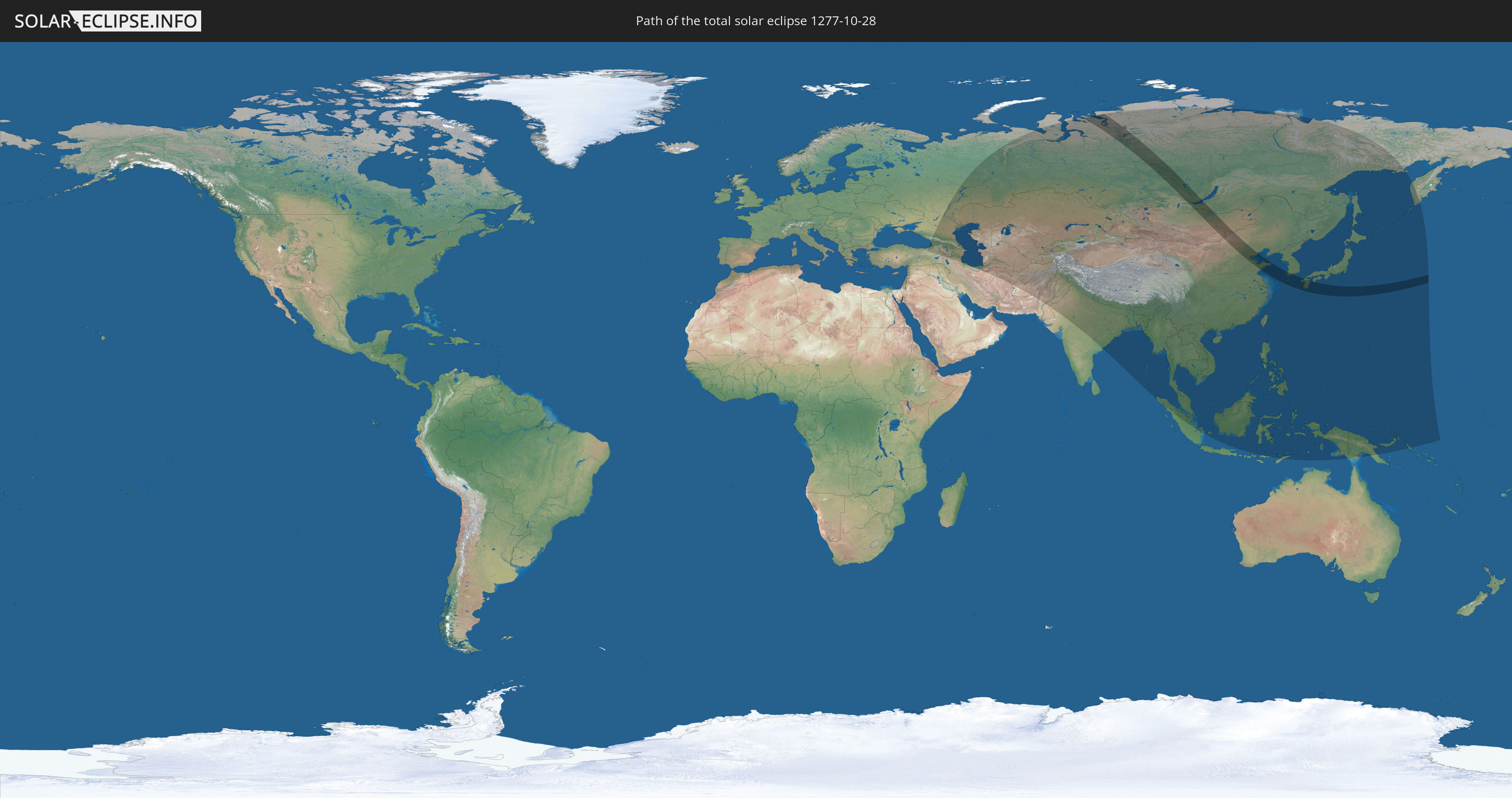
Die Sonnenfinsternis am 10/28/1277 kann man in 43 Ländern als partielle Sonnenfinsternis beobachten.
Der Finsternispfad verläuft durch 5 Länder. Nur in diesen Ländern ist sie als total Sonnenfinsternis zu sehen.
In den folgenden Ländern ist die Sonnenfinsternis total zu sehen
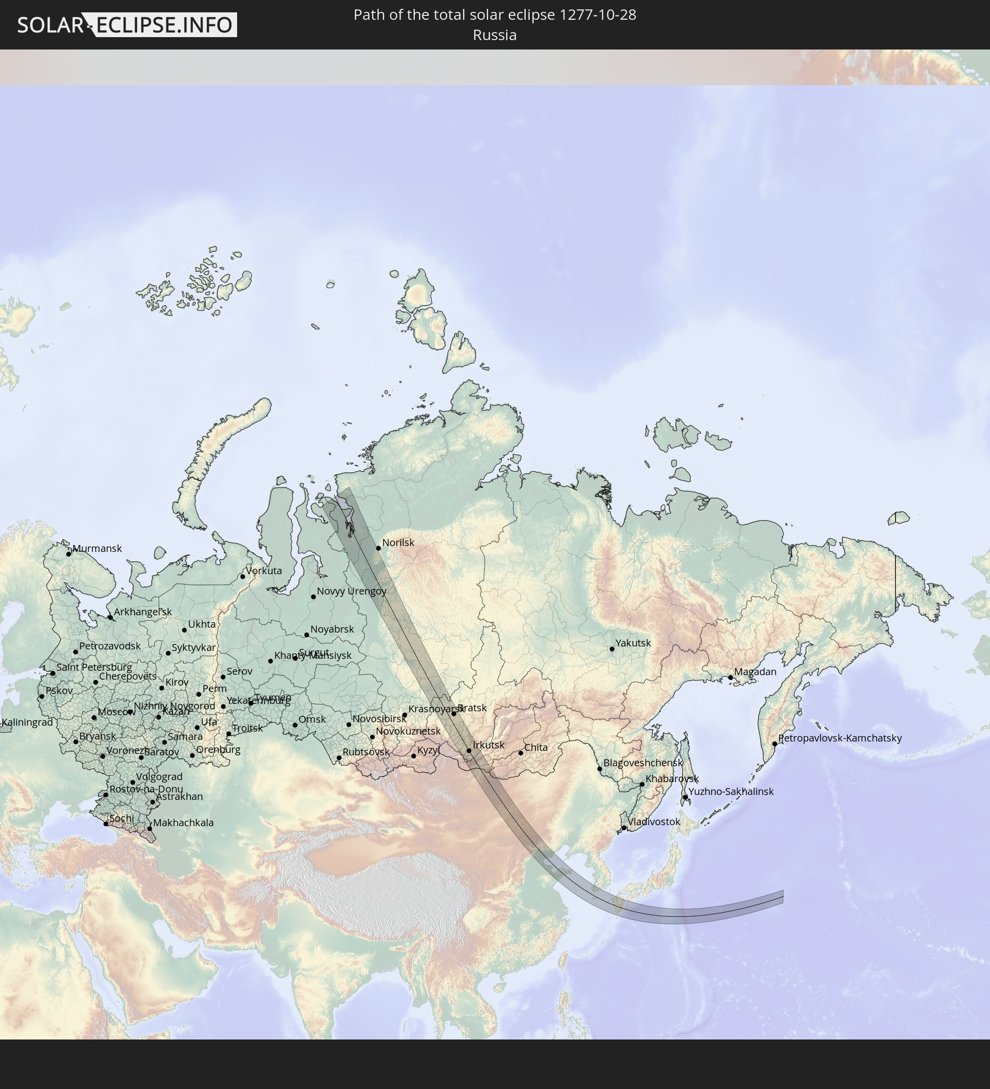 Russia
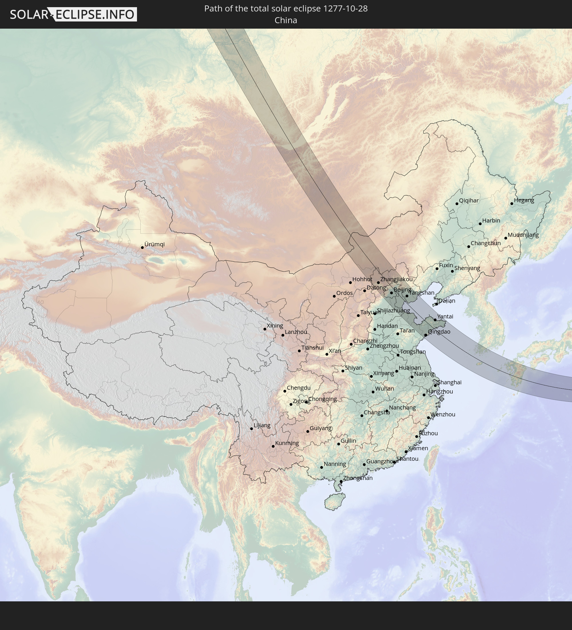 China
China
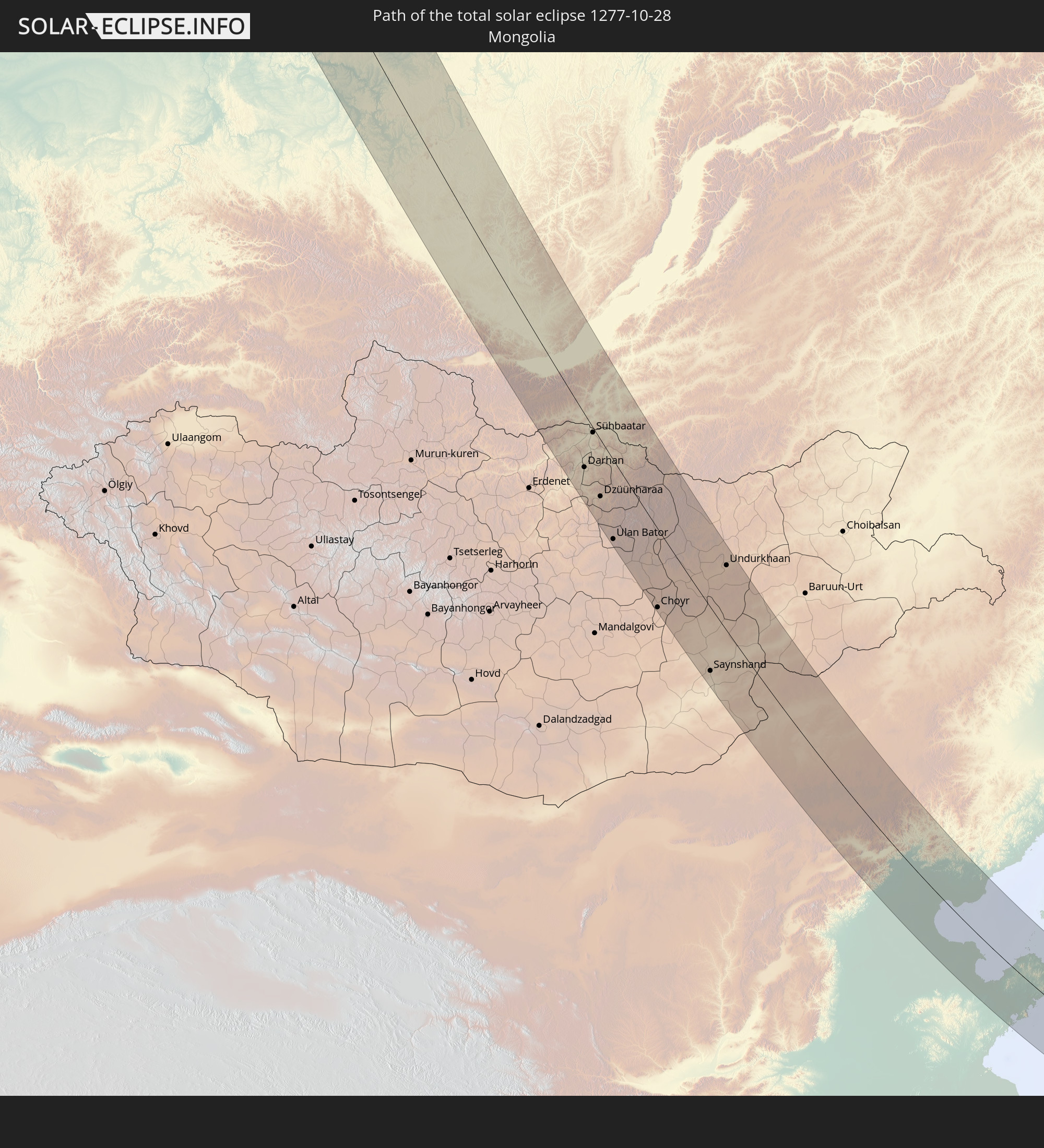 Mongolia
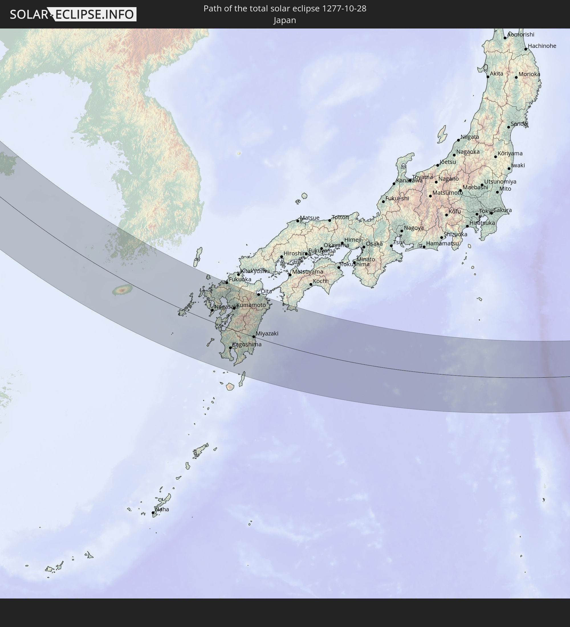 Japan
Japan
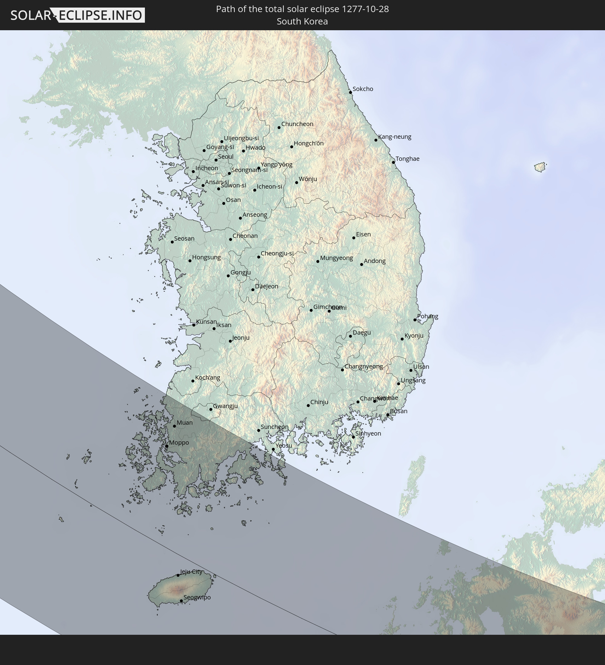 South Korea
In den folgenden Ländern ist die Sonnenfinsternis partiell zu sehen
 Russia
 Turkey
 Georgia
 Armenia
 Iran
Iran
 Azerbaijan
 Kazakhstan
 Turkmenistan
 Uzbekistan
 Afghanistan
 Pakistan
 Tajikistan
 India
India
 Kyrgyzstan
 China
China
 Nepal
Nepal
 Mongolia
 Bangladesh
 Bhutan
 Myanmar
 Indonesia
 Thailand
 Malaysia
 Laos
Laos
 Vietnam
 Cambodia
 Singapore
 Macau
Macau
 Hong Kong
 Brunei
 Taiwan
 Philippines
 Japan
Japan
 East Timor
 North Korea
 South Korea
 Palau
Palau
 Federated States of Micronesia
 Papua New Guinea
 Guam
Guam
 Northern Mariana Islands
 Solomon Islands
 Marshall Islands
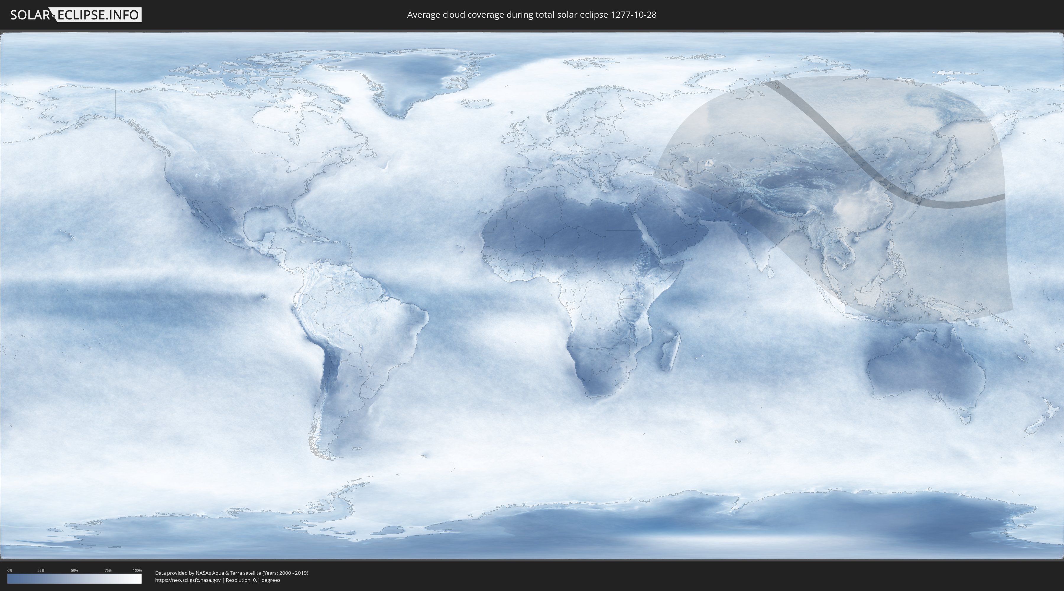
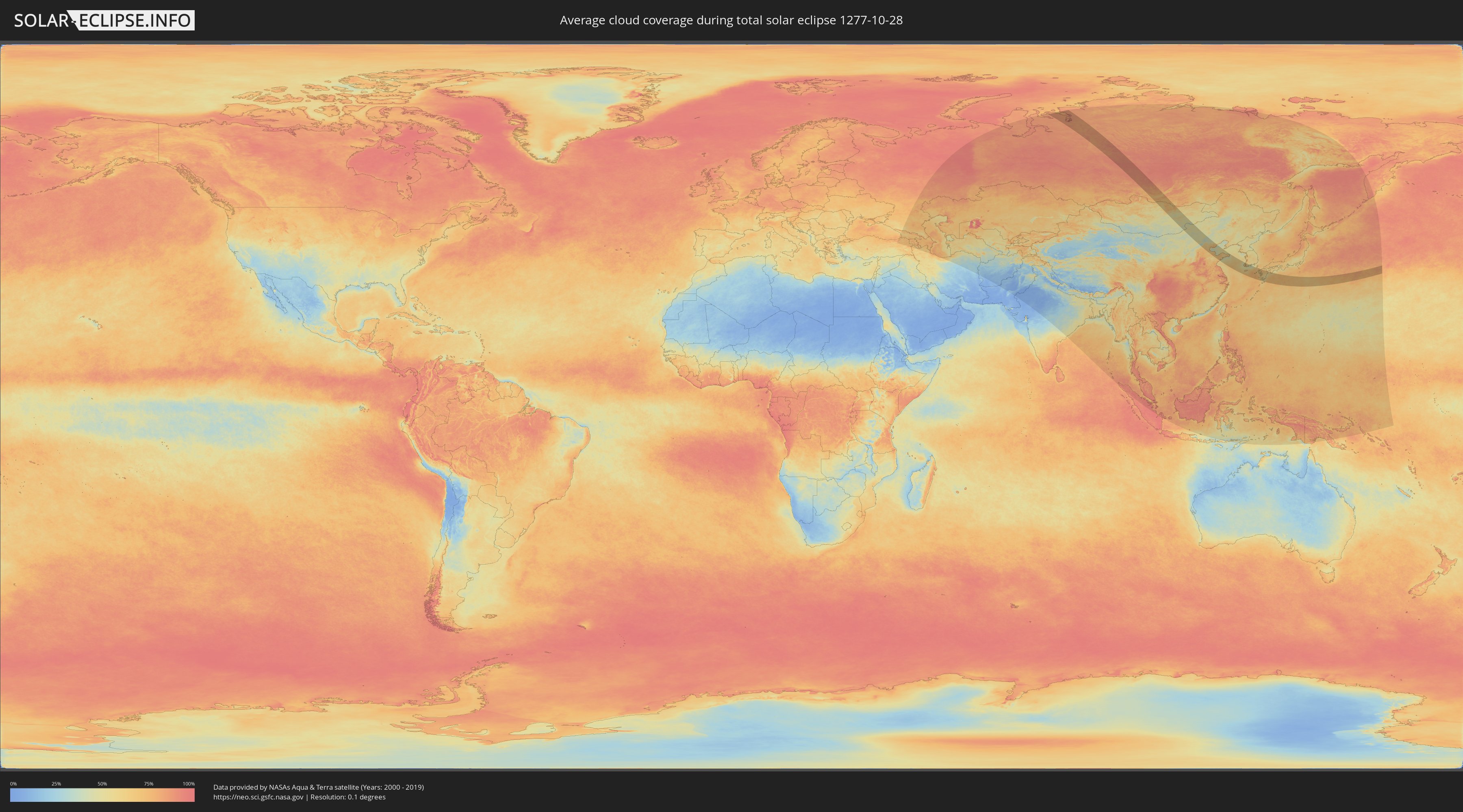
How will be the weather during the total solar eclipse on 10/28/1277?
Where is the best place to see the total solar eclipse of 10/28/1277?
The following maps show the average cloud coverage for the day of the total solar eclipse.
With the help of these maps, it is possible to find the place along the eclipse path, which has the best
chance of a cloudless sky.
Nevertheless, you should consider local circumstances and inform about the weather of your chosen
observation site.
The data is provided by NASAs satellites
AQUA and TERRA.
The cloud maps are averaged over a period of 19 years (2000 - 2019).
Detailed country maps
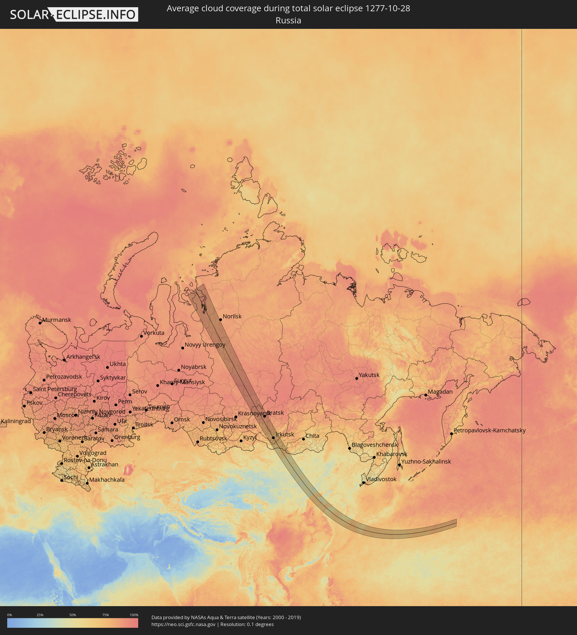 Russia
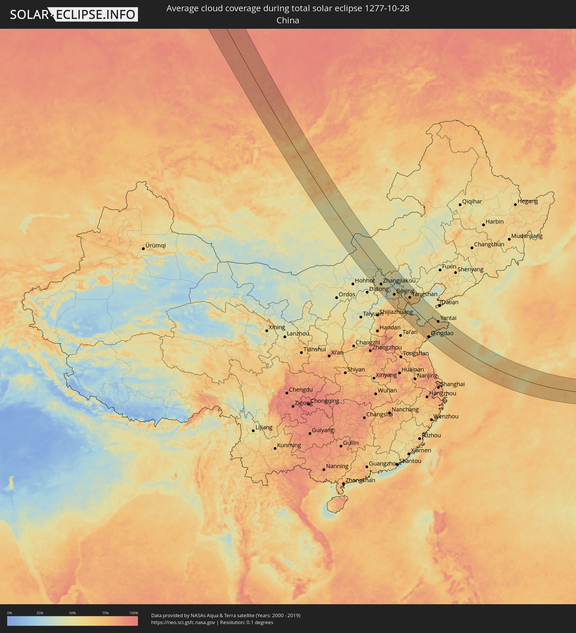 China
China
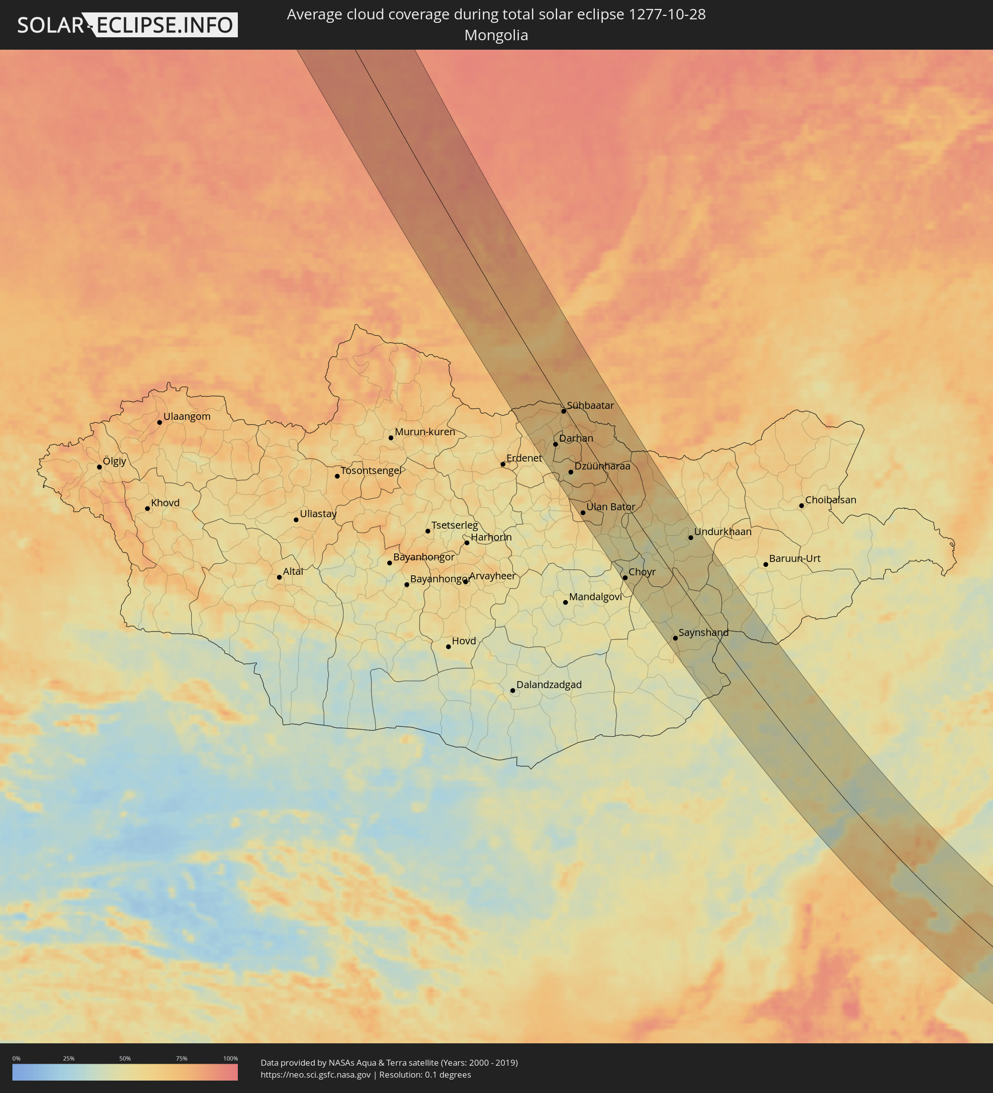 Mongolia
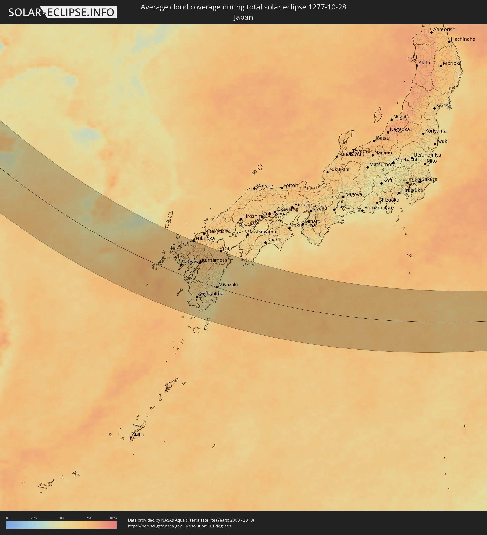 Japan
Japan
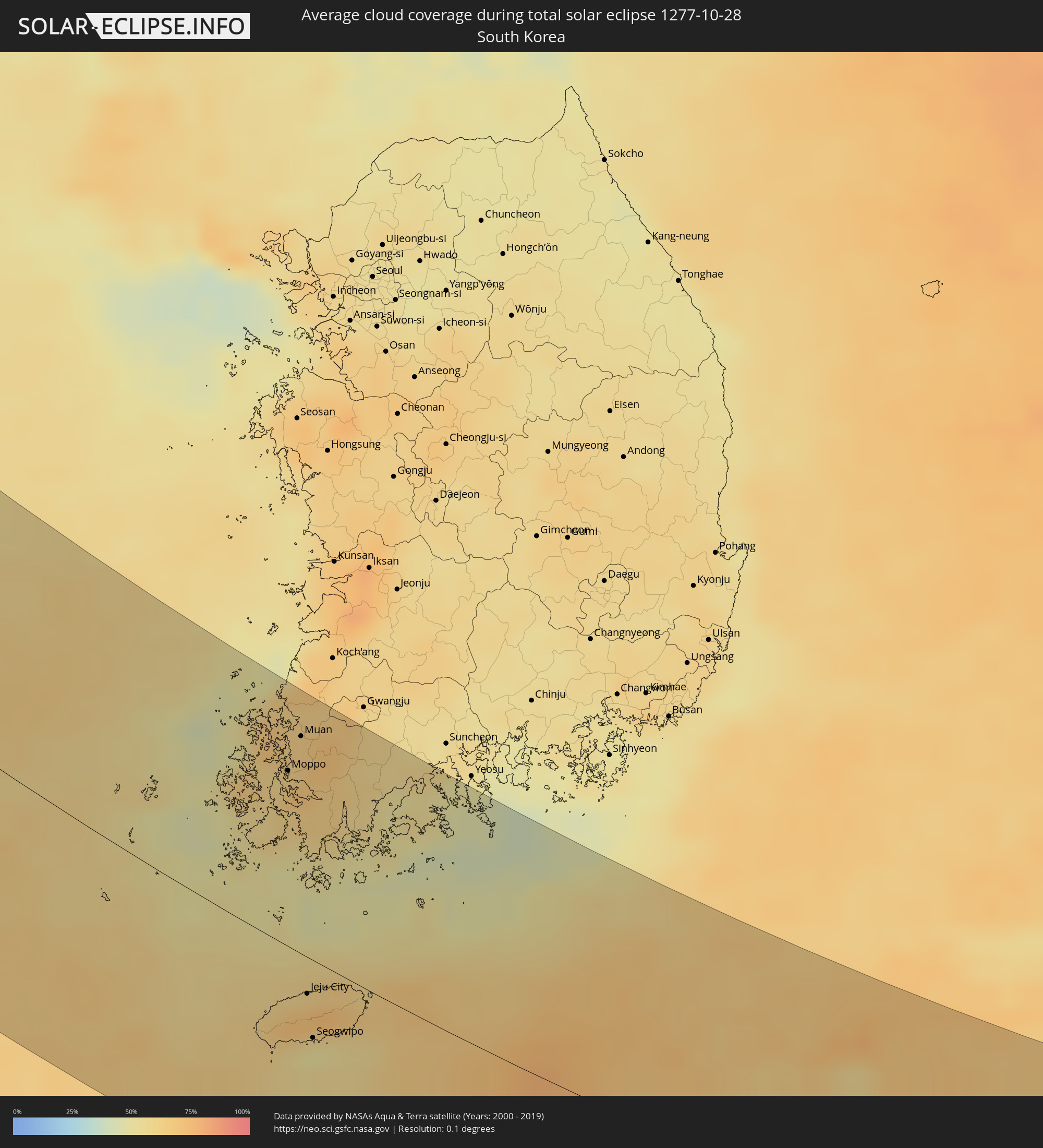 South Korea
Cities inside the path of the eclipse
The following table shows all locations with a population of more than 5,000 inside the eclipse path. Cities which have more than 100,000 inhabitants are marked bold. A click at the locations opens a detailed map.
| City | Type | Eclipse duration | Local time of max. eclipse | Distance to central line | Ø Cloud coverage |
|
Dudinka, Krasnoyarskiy
|
total | - | 10:46:11 UTC+06:11 | 45 km | 84% |
|
Igarka, Krasnoyarskiy
|
total | - | 10:45:28 UTC+06:11 | 36 km | 85% |
|
Kayyerkan, Krasnoyarskiy
|
total | - | 10:47:03 UTC+06:11 | 99 km | 84% |
|
Boguchany, Krasnoyarskiy
|
total | - | 10:52:16 UTC+06:11 | 35 km | 89% |
|
Kodinsk, Krasnoyarskiy
|
total | - | 10:53:57 UTC+06:11 | 70 km | 90% |
|
Lesogorsk, Irkutsk
|
total | - | 11:40:23 UTC+06:57 | 56 km | 87% |
|
Chunskiy, Irkutsk
|
total | - | 11:40:31 UTC+06:57 | 47 km | 87% |
|
Tulun, Irkutsk
|
total | - | 11:41:57 UTC+06:57 | 81 km | 86% |
|
Vikhorevka, Irkutsk
|
total | - | 11:42:11 UTC+06:57 | 38 km | 90% |
|
Kuytun, Irkutsk
|
total | - | 11:43:05 UTC+06:57 | 42 km | 83% |
|
Bratsk, Irkutsk
|
total | - | 11:42:39 UTC+06:57 | 63 km | 89% |
|
Zima, Irkutsk
|
total | - | 11:43:51 UTC+06:57 | 36 km | 80% |
|
Sayansk, Irkutsk
|
total | - | 11:43:55 UTC+06:57 | 18 km | 85% |
|
Zalari, Irkutsk
|
total | - | 11:44:32 UTC+06:57 | 30 km | 83% |
|
Kutulik, Irkutsk
|
total | - | 11:44:57 UTC+06:57 | 26 km | 81% |
|
Ust’-Uda, Irkutsk
|
total | - | 11:44:55 UTC+06:57 | 34 km | 80% |
|
Cheremkhovo, Irkutsk
|
total | - | 11:45:22 UTC+06:57 | 21 km | 81% |
|
Mishelevka, Irkutsk
|
total | - | 11:45:37 UTC+06:57 | 32 km | 78% |
|
Svirsk, Irkutsk
|
total | - | 11:45:43 UTC+06:57 | 10 km | 82% |
|
Tayturka, Irkutsk
|
total | - | 11:45:58 UTC+06:57 | 15 km | 78% |
|
Sredniy, Irkutsk
|
total | - | 11:46:00 UTC+06:57 | 12 km | 78% |
|
Usol’ye-Sibirskoye, Irkutsk
|
total | - | 11:46:15 UTC+06:57 | 11 km | 78% |
|
Slyudyanka, Irkutsk
|
total | - | 11:46:50 UTC+06:57 | 71 km | 68% |
|
Bokhan, Irkutsk
|
total | - | 11:46:13 UTC+06:57 | 19 km | 77% |
|
Angarsk, Irkutsk
|
total | - | 11:46:38 UTC+06:57 | 9 km | 80% |
|
Meget, Irkutsk
|
total | - | 11:46:54 UTC+06:57 | 7 km | 82% |
|
Shelekhov, Irkutsk
|
total | - | 11:47:04 UTC+06:57 | 15 km | 77% |
|
Baykal’sk, Irkutsk
|
total | - | 11:47:28 UTC+06:57 | 54 km | 70% |
|
Markova, Irkutsk
|
total | - | 11:47:12 UTC+06:57 | 9 km | 77% |
|
Irkutsk, Irkutsk
|
total | - | 11:47:16 UTC+06:57 | 1 km | 78% |
|
Vydreno, Respublika Buryatiya
|
total | - | 11:48:07 UTC+06:57 | 27 km | 69% |
|
Ust’-Ordynskiy, Irkutsk
|
total | - | 11:47:35 UTC+06:57 | 56 km | 77% |
|
Rechka-Vydrino, Respublika Buryatiya
|
total | - | 11:48:22 UTC+06:57 | 14 km | 69% |
|
Petropavlovka, Respublika Buryatiya
|
total | - | 11:49:28 UTC+06:57 | 37 km | 70% |
|
Darhan, Darhan Uul
|
total | - | 12:01:24 UTC+07:07 | 68 km | 60% |
|
Sühbaatar, Selenge
|
total | - | 12:01:19 UTC+07:07 | 6 km | 65% |
|
Kyakhta, Respublika Buryatiya
|
total | - | 11:51:07 UTC+06:57 | 16 km | 70% |
|
Dzüünharaa, Selenge
|
total | - | 12:02:33 UTC+07:07 | 73 km | 53% |
|
Gusinoozyorsk, Respublika Buryatiya
|
total | - | 11:50:37 UTC+06:57 | 73 km | 74% |
|
Ulan Bator, Ulaanbaatar
|
total | - | 12:03:48 UTC+07:07 | 105 km | 66% |
|
Зуунмод, Central Aimak
|
total | - | 12:04:03 UTC+07:07 | 114 km | 59% |
|
Dzuunmod, Central Aimak
|
total | - | 12:04:03 UTC+07:07 | 114 km | 59% |
|
Bichura, Respublika Buryatiya
|
total | - | 11:52:29 UTC+06:57 | 99 km | 69% |
|
Choyr, Govĭ-Sumber
|
total | - | 12:07:07 UTC+07:07 | 111 km | 55% |
|
Saynshand, East Gobi Aymag
|
total | - | 12:11:02 UTC+07:07 | 95 km | 53% |
|
Undurkhaan, Hentiy
|
total | - | 12:09:40 UTC+07:07 | 94 km | 48% |
|
Zhangjiakou, Hebei
|
total | - | 13:15:25 UTC+08:00 | 71 km | 57% |
|
Zhangjiakou Shi Xuanhua Qu, Hebei
|
total | - | 13:15:56 UTC+08:00 | 75 km | 56% |
|
Fangshan, Beijing
|
total | - | 13:18:40 UTC+08:00 | 83 km | 59% |
|
Mentougou, Beijing
|
total | - | 13:18:31 UTC+08:00 | 58 km | 55% |
|
Liangxiang, Beijing
|
total | - | 13:18:50 UTC+08:00 | 71 km | 61% |
|
Changping, Beijing
|
total | - | 13:18:24 UTC+08:00 | 28 km | 54% |
|
Daxing, Beijing
|
total | - | 13:19:09 UTC+08:00 | 58 km | 63% |
|
Beijing, Beijing
|
total | - | 13:19:03 UTC+08:00 | 41 km | 64% |
|
Shunyi, Beijing
|
total | - | 13:19:12 UTC+08:00 | 9 km | 60% |
|
Tongzhou, Beijing
|
total | - | 13:19:30 UTC+08:00 | 25 km | 59% |
|
Langfang, Hebei
|
total | - | 13:20:04 UTC+08:00 | 52 km | 65% |
|
Yangliuqing, Tianjin
|
total | - | 13:21:03 UTC+08:00 | 61 km | 60% |
|
Tianjin, Tianjin
|
total | - | 13:21:21 UTC+08:00 | 50 km | 67% |
|
Xianshuigu, Tianjin
|
total | - | 13:21:54 UTC+08:00 | 49 km | 64% |
|
Tanggu, Tianjin
|
total | - | 13:22:18 UTC+08:00 | 30 km | 67% |
|
Hangu, Tianjin
|
total | - | 13:22:15 UTC+08:00 | 4 km | 71% |
|
Fengrun, Hebei
|
total | - | 13:22:02 UTC+08:00 | 61 km | 65% |
|
Tangshan, Hebei
|
total | - | 13:22:24 UTC+08:00 | 50 km | 65% |
|
Linxi, Hebei
|
total | - | 13:22:45 UTC+08:00 | 73 km | 64% |
|
Tangjiazhuang, Hebei
|
total | - | 13:22:42 UTC+08:00 | 75 km | 71% |
|
Shengli, Shandong
|
total | - | 13:25:50 UTC+08:00 | 102 km | 75% |
|
Shouguang, Shandong
|
total | - | 13:27:04 UTC+08:00 | 134 km | 71% |
|
Weifang, Shandong
|
total | - | 13:27:56 UTC+08:00 | 127 km | 65% |
|
Gaomi, Shandong
|
total | - | 13:29:32 UTC+08:00 | 115 km | 72% |
|
Weichanglu, Shandong
|
total | - | 13:28:44 UTC+08:00 | 38 km | 67% |
|
Pingdu, Shandong
|
total | - | 13:29:18 UTC+08:00 | 70 km | 69% |
|
Jiaozhou, Shandong
|
total | - | 13:30:06 UTC+08:00 | 109 km | 67% |
|
Qingdao, Shandong
|
total | - | 13:31:03 UTC+08:00 | 107 km | 54% |
|
Luofeng, Shandong
|
total | - | 13:29:16 UTC+08:00 | 5 km | 70% |
|
Jimo, Shandong
|
total | - | 13:30:45 UTC+08:00 | 73 km | 64% |
|
Laixi, Shandong
|
total | - | 13:30:11 UTC+08:00 | 30 km | 70% |
|
Laiyang, Shandong
|
total | - | 13:30:21 UTC+08:00 | 9 km | 64% |
|
Dengzhou, Shandong
|
total | - | 13:29:14 UTC+08:00 | 62 km | 65% |
|
Zhuangyuan, Shandong
|
total | - | 13:30:04 UTC+08:00 | 25 km | 62% |
|
Dongcun, Shandong
|
total | - | 13:31:24 UTC+08:00 | 0 km | 67% |
|
Qingyang, Shandong
|
total | - | 13:30:32 UTC+08:00 | 66 km | 67% |
|
Yantai, Shandong
|
total | - | 13:30:52 UTC+08:00 | 75 km | 66% |
|
Tianfu, Shandong
|
total | - | 13:32:18 UTC+08:00 | 87 km | 68% |
|
Weihai, Shandong
|
total | - | 13:31:57 UTC+08:00 | 117 km | 63% |
|
Yatou, Shandong
|
total | - | 13:33:01 UTC+08:00 | 105 km | 67% |
|
Sinan, Jeollanam-do
|
total | - | 14:10:33 UTC+08:27 | 87 km | 66% |
|
Gaigeturi, Jeju-do
|
total | - | 14:13:02 UTC+08:27 | 34 km | 64% |
|
Moppo, Jeollanam-do
|
total | - | 14:11:04 UTC+08:27 | 97 km | 67% |
|
Muan, Jeollanam-do
|
total | - | 14:10:54 UTC+08:27 | 120 km | 66% |
|
Jeju City, Jeju-do
|
total | - | 14:13:18 UTC+08:27 | 21 km | 70% |
|
Seogwipo, Jeju-do
|
total | - | 14:13:46 UTC+08:27 | 44 km | 57% |
|
Haenam, Jeollanam-do
|
total | - | 14:11:45 UTC+08:27 | 86 km | 63% |
|
Naju, Jeollanam-do
|
total | - | 14:11:14 UTC+08:27 | 135 km | 70% |
|
Sasebo, Nagasaki
|
total | - | 14:51:10 UTC+09:00 | 74 km | 65% |
|
Togitsu, Nagasaki
|
total | - | 14:51:54 UTC+09:00 | 45 km | 64% |
|
Imarichō-kō, Saga Prefecture
|
total | - | 14:51:14 UTC+09:00 | 91 km | 67% |
|
Nagasaki, Nagasaki
|
total | - | 14:52:05 UTC+09:00 | 37 km | 64% |
|
Karatsu, Saga Prefecture
|
total | - | 14:51:06 UTC+09:00 | 112 km | 67% |
|
Takeochō-takeo, Saga Prefecture
|
total | - | 14:51:35 UTC+09:00 | 87 km | 69% |
|
Isahaya, Nagasaki
|
total | - | 14:52:11 UTC+09:00 | 52 km | 65% |
|
Kashima, Saga Prefecture
|
total | - | 14:51:50 UTC+09:00 | 81 km | 65% |
|
Hondomachi-hondo, Kumamoto
|
total | - | 14:53:00 UTC+09:00 | 17 km | 62% |
|
Maebaru-chūō, Fukuoka
|
total | - | 14:51:17 UTC+09:00 | 132 km | 68% |
|
Satsumasendai, Kagoshima
|
total | - | 14:54:14 UTC+09:00 | 46 km | 60% |
|
Saga, Saga Prefecture
|
total | - | 14:51:58 UTC+09:00 | 102 km | 68% |
|
Izumi, Kagoshima
|
total | - | 14:53:55 UTC+09:00 | 16 km | 64% |
|
Shimabara, Nagasaki
|
total | - | 14:52:47 UTC+09:00 | 57 km | 62% |
|
Minamata, Kumamoto
|
total | - | 14:53:45 UTC+09:00 | 1 km | 61% |
|
Fukuoka, Fukuoka
|
total | - | 14:51:33 UTC+09:00 | 144 km | 68% |
|
Ōmuta, Fukuoka
|
total | - | 14:52:31 UTC+09:00 | 86 km | 65% |
|
Kurume, Fukuoka
|
total | - | 14:52:10 UTC+09:00 | 118 km | 72% |
|
Kagoshima, Kagoshima
|
total | - | 14:55:02 UTC+09:00 | 64 km | 60% |
|
Tamana, Kumamoto
|
total | - | 14:52:53 UTC+09:00 | 78 km | 66% |
|
Honmachi, Kumamoto
|
total | - | 14:53:36 UTC+09:00 | 36 km | 61% |
|
Ibusuki, Kagoshima
|
total | - | 14:55:43 UTC+09:00 | 96 km | 54% |
|
Amagi, Fukuoka
|
total | - | 14:52:13 UTC+09:00 | 133 km | 70% |
|
Yamaga, Kumamoto
|
total | - | 14:52:54 UTC+09:00 | 92 km | 70% |
|
Uekimachi-mōno, Kumamoto
|
total | - | 14:53:06 UTC+09:00 | 80 km | 69% |
|
Kumamoto, Kumamoto
|
total | - | 14:53:15 UTC+09:00 | 70 km | 70% |
|
Hitoyoshi, Kumamoto
|
total | - | 14:54:18 UTC+09:00 | 11 km | 59% |
|
Kokubu-matsuki, Kagoshima
|
total | - | 14:55:06 UTC+09:00 | 39 km | 56% |
|
Kanoya, Kagoshima
|
total | - | 14:55:48 UTC+09:00 | 74 km | 57% |
|
Ōzu, Kumamoto
|
total | - | 14:53:25 UTC+09:00 | 84 km | 69% |
|
Hita, Oita
|
total | - | 14:52:49 UTC+09:00 | 132 km | 69% |
|
Kobayashi, Miyazaki
|
total | - | 14:55:02 UTC+09:00 | 6 km | 58% |
|
Miyakonojō, Miyazaki
|
total | - | 14:55:34 UTC+09:00 | 30 km | 60% |
|
Nichinan, Miyazaki
|
total | - | 14:56:15 UTC+09:00 | 35 km | 54% |
|
Tsuma, Miyazaki
|
total | - | 14:55:29 UTC+09:00 | 19 km | 58% |
|
Miyazaki, Miyazaki
|
total | - | 14:55:48 UTC+09:00 | 0 km | 59% |
|
Ōita, Oita
|
total | - | 14:53:57 UTC+09:00 | 144 km | 67% |
|
Nobeoka, Miyazaki
|
total | - | 14:55:07 UTC+09:00 | 78 km | 54% |
|
Usuki, Oita
|
total | - | 14:54:27 UTC+09:00 | 139 km | 68% |
|
Saiki, Oita
|
total | - | 14:54:52 UTC+09:00 | 123 km | 64% |