Total solar eclipse of 11/30/1331
| Day of week: | Friday |
| Maximum duration of eclipse: | 03m09s |
| Maximum width of eclipse path: | 265 km |
| Saros cycle: | 102 |
| Coverage: | 100% |
| Magnitude: | 1.038 |
| Gamma: | 0.8766 |
Wo kann man die Sonnenfinsternis vom 11/30/1331 sehen?
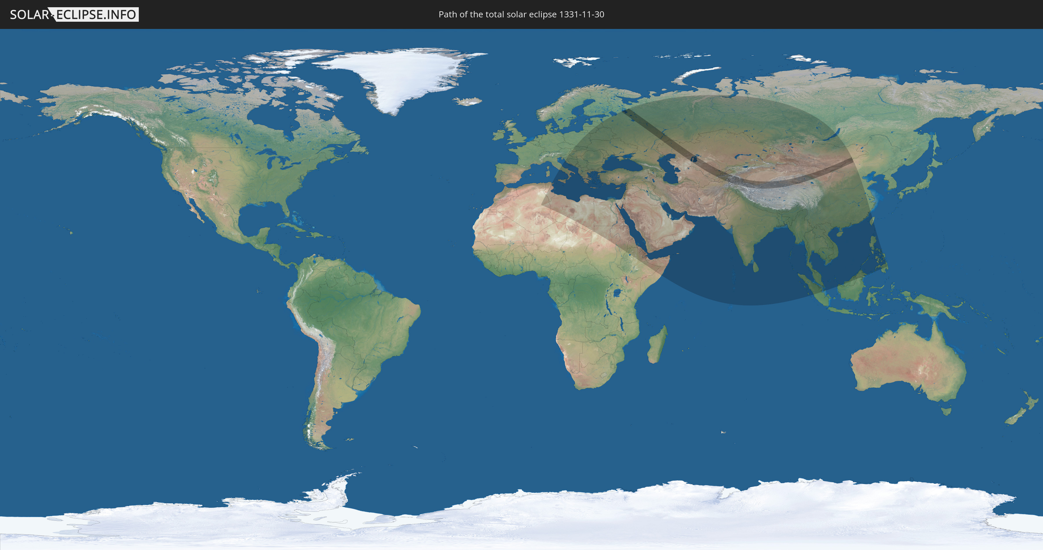
Die Sonnenfinsternis am 11/30/1331 kann man in 78 Ländern als partielle Sonnenfinsternis beobachten.
Der Finsternispfad verläuft durch 10 Länder. Nur in diesen Ländern ist sie als total Sonnenfinsternis zu sehen.
In den folgenden Ländern ist die Sonnenfinsternis total zu sehen
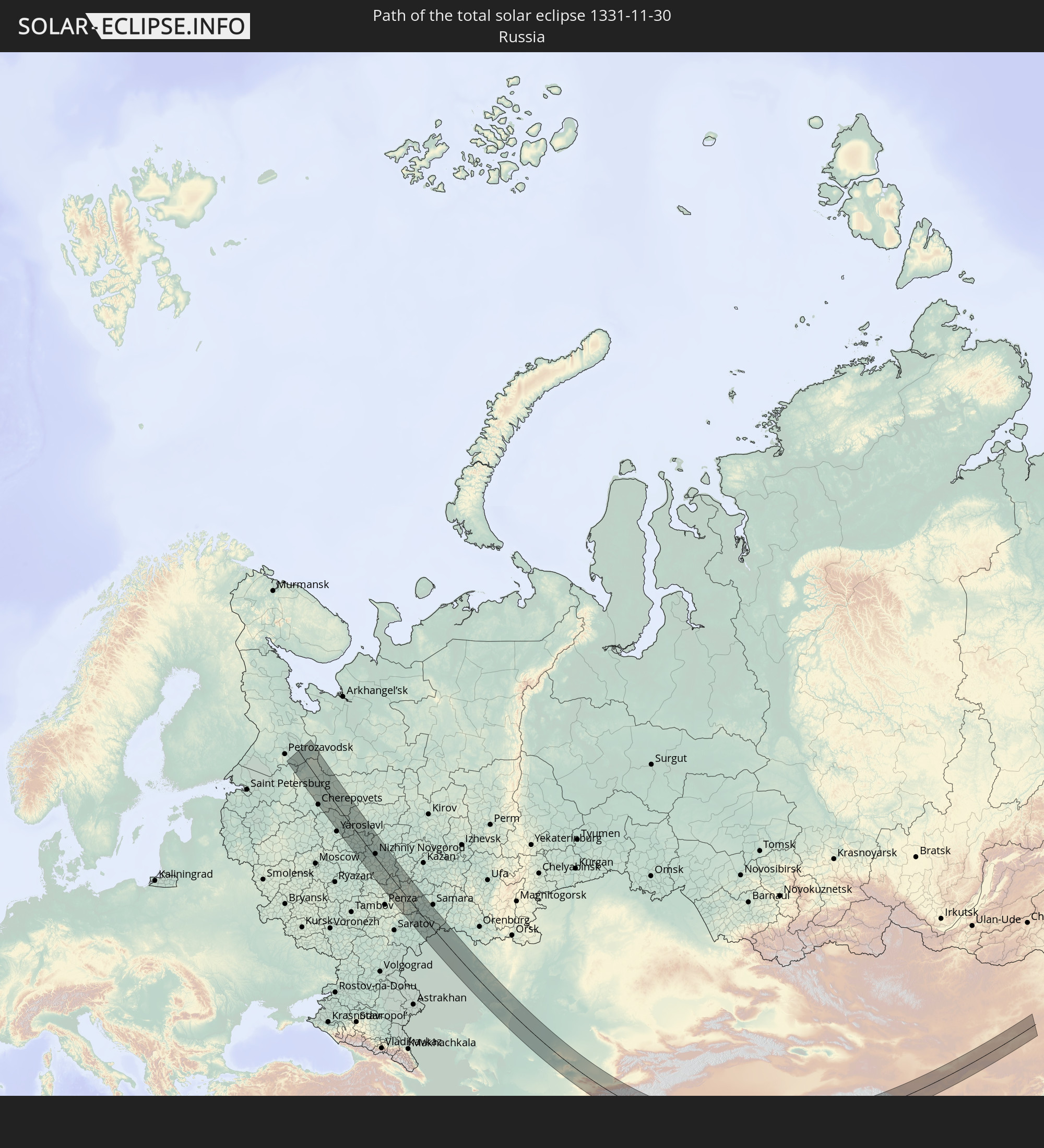 Russia
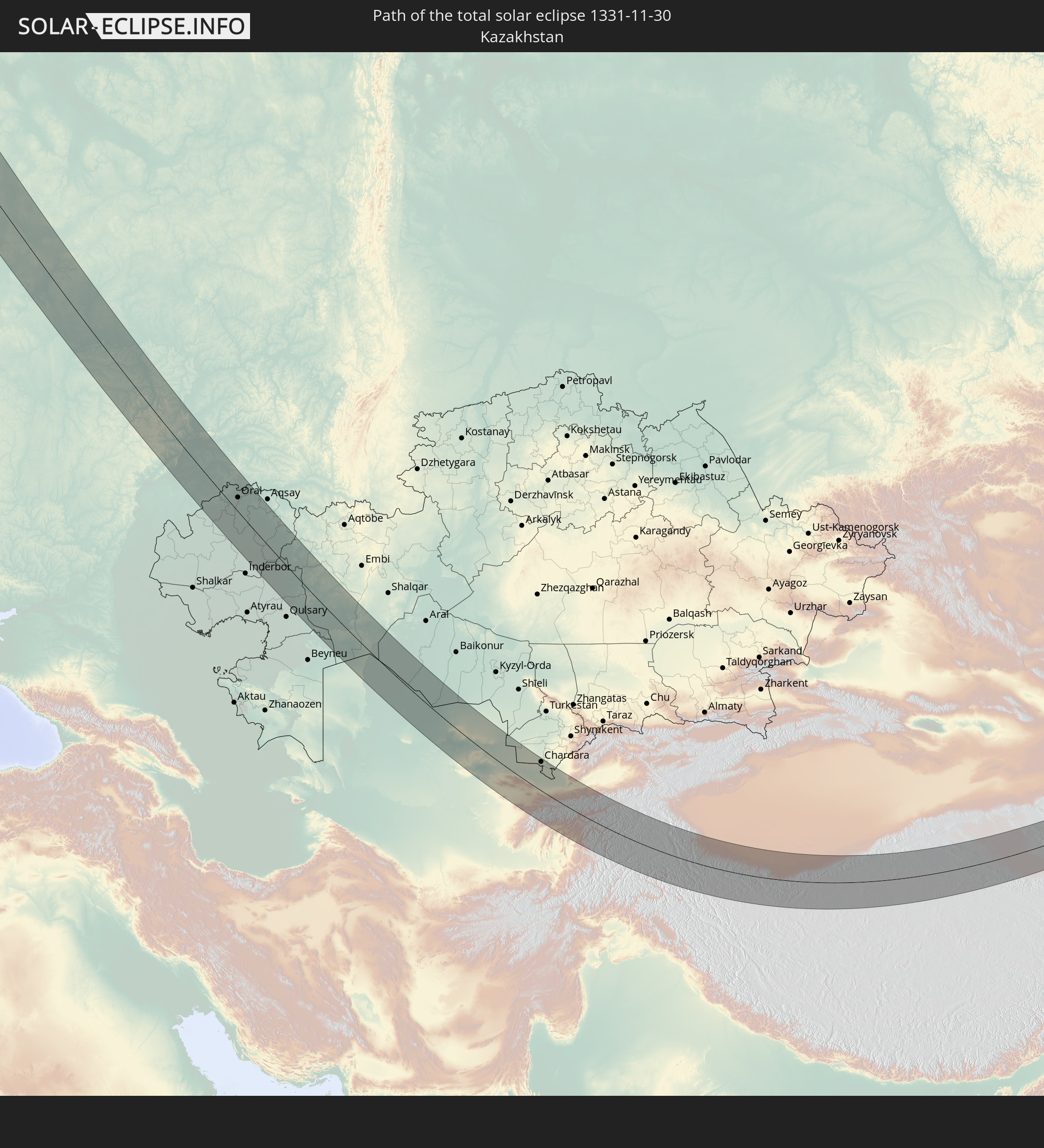 Kazakhstan
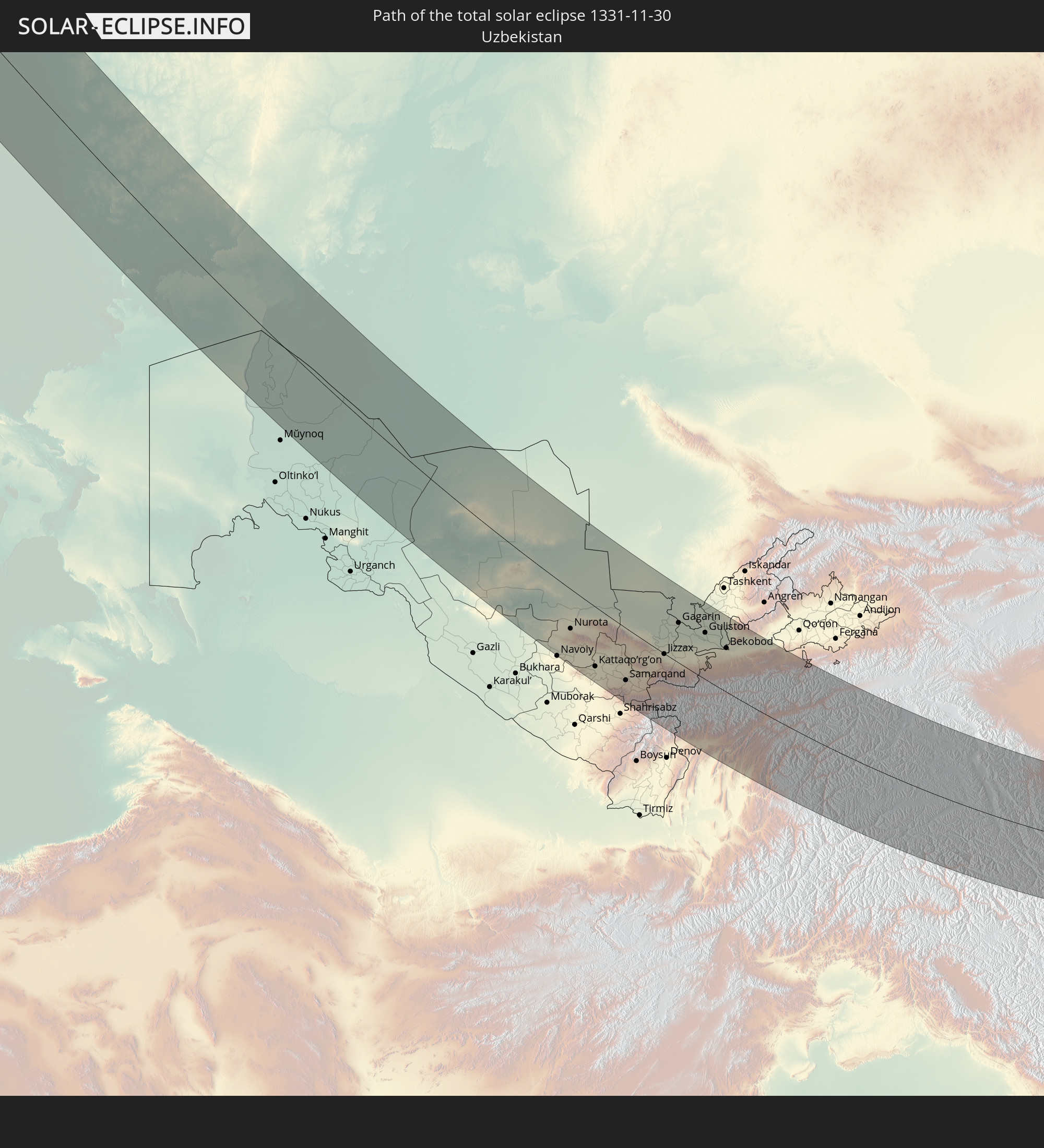 Uzbekistan
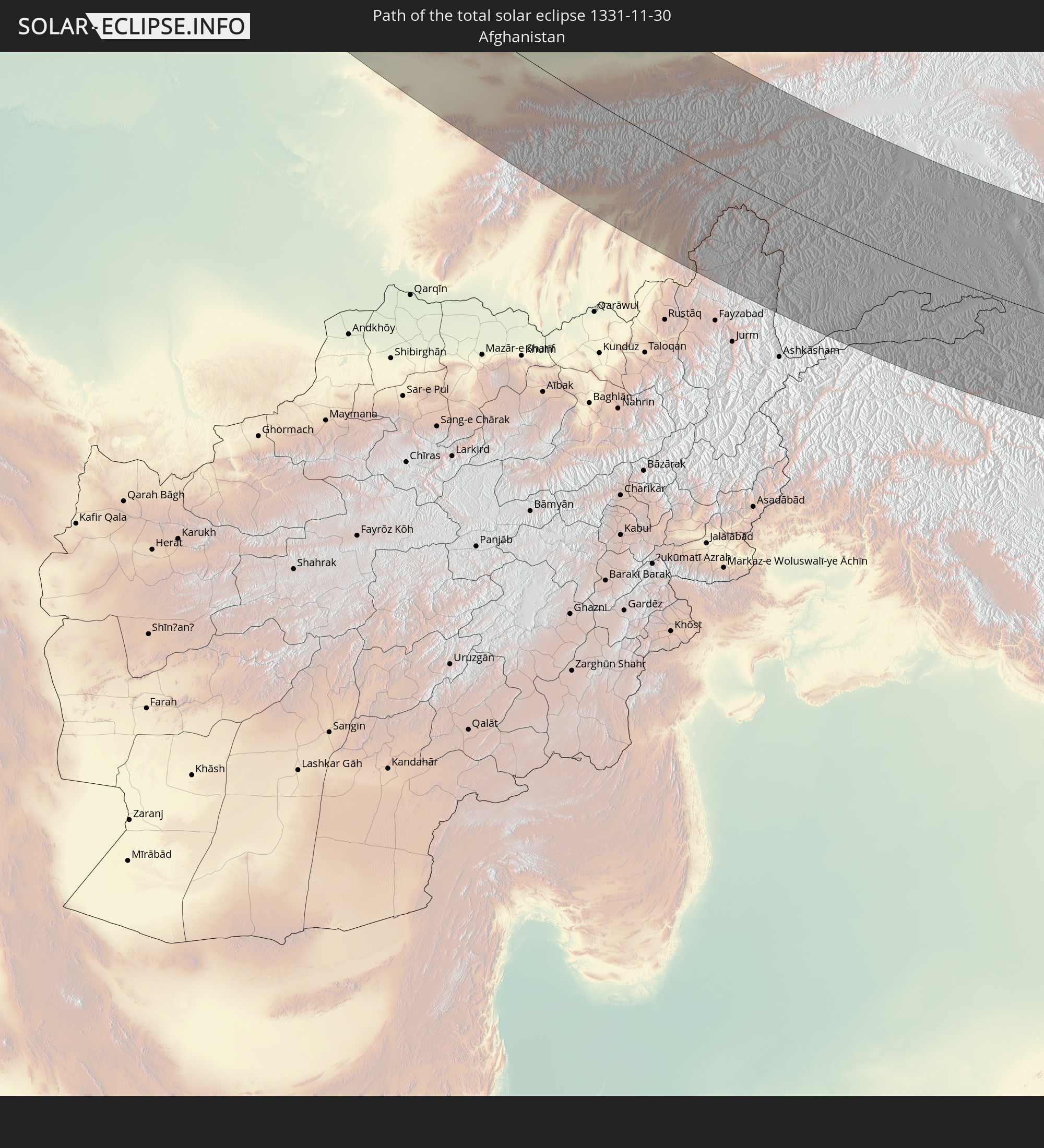 Afghanistan
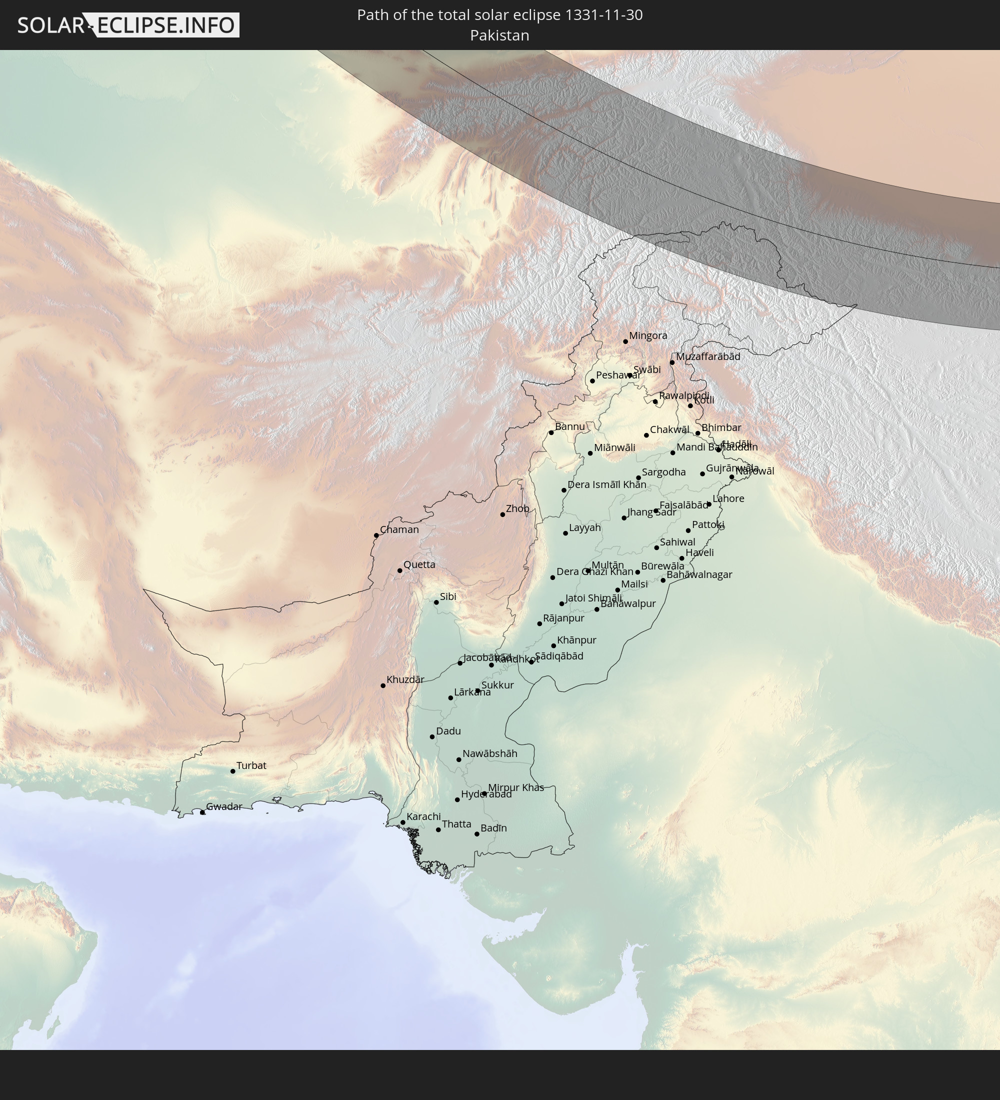 Pakistan
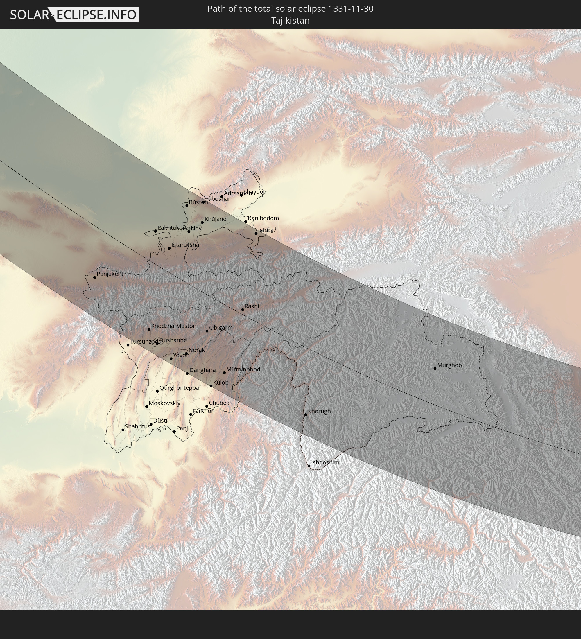 Tajikistan
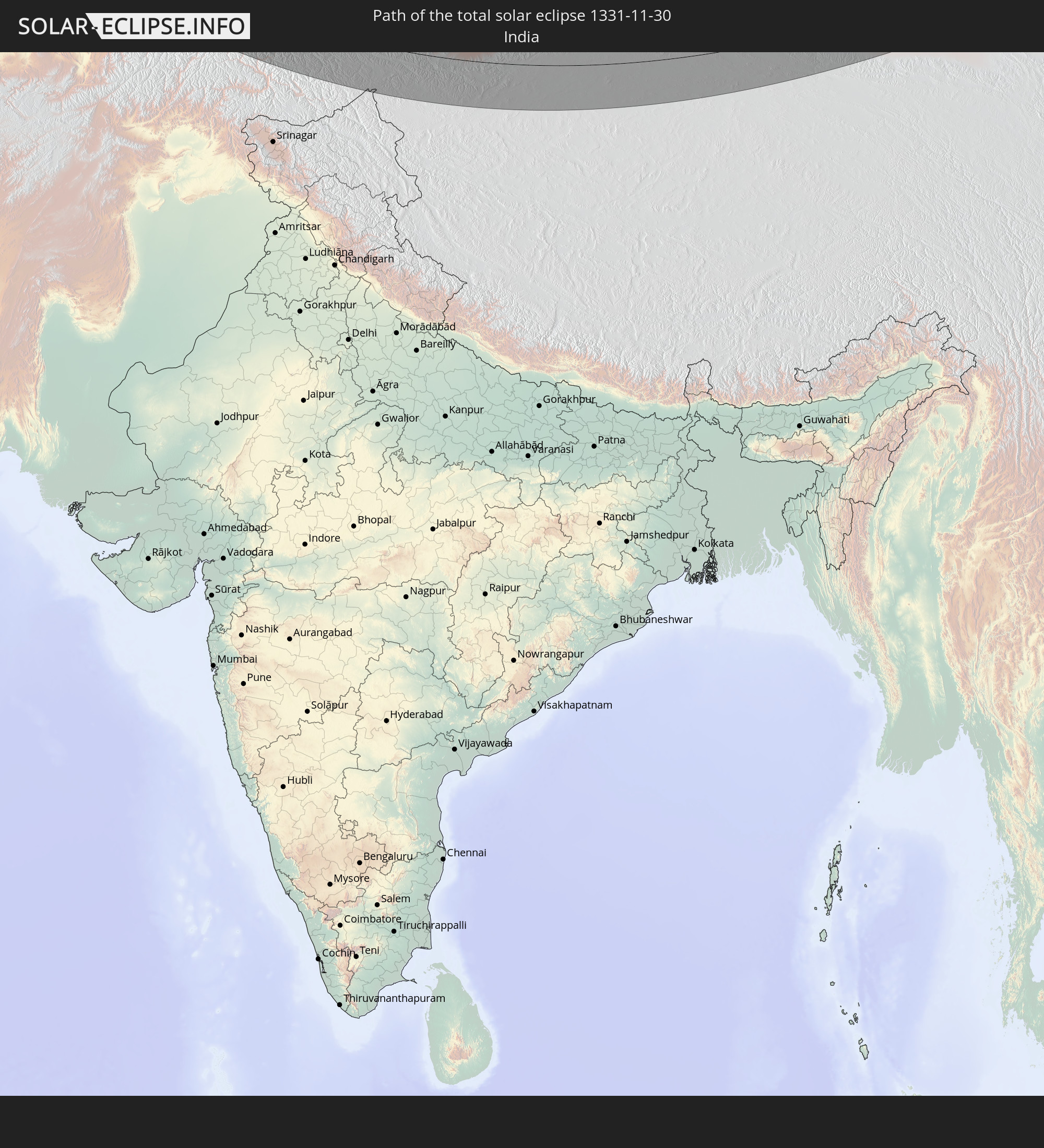 India
India
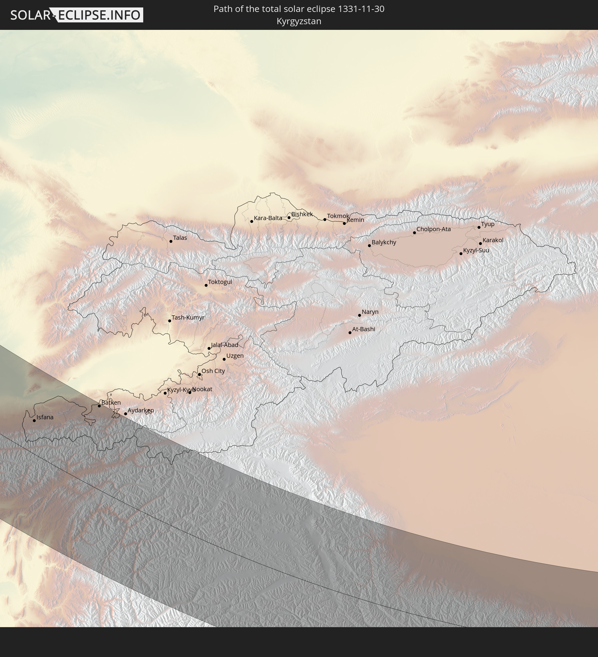 Kyrgyzstan
 China
China
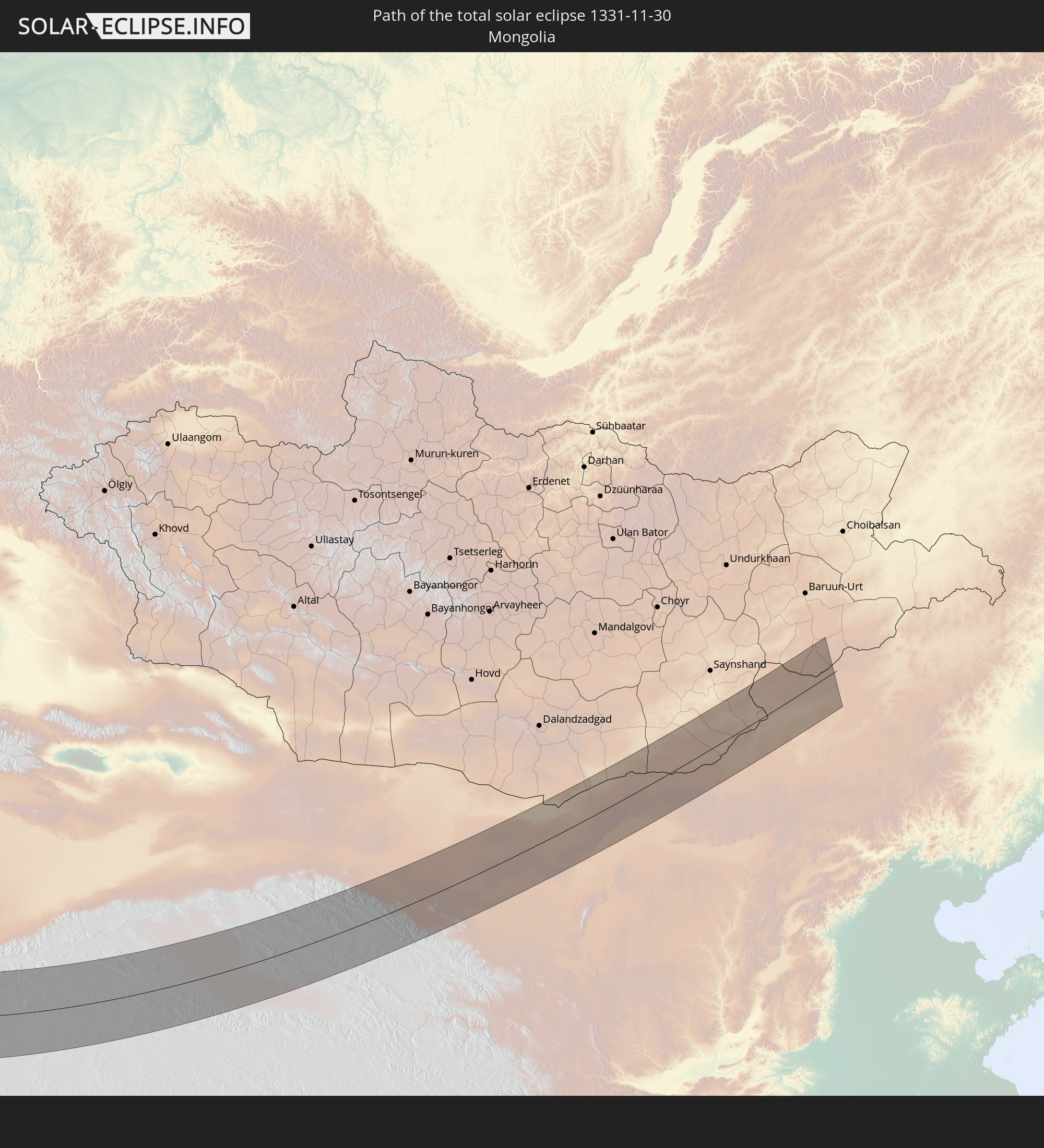 Mongolia
In den folgenden Ländern ist die Sonnenfinsternis partiell zu sehen
 Russia
 Algeria
 Italy
Italy
 Tunisia
 Libya
Libya
 Czechia
 Slovenia
 Croatia
 Poland
 Malta
Malta
 Bosnia and Herzegovina
 Hungary
 Slovakia
 Montenegro
 Serbia
 Albania
 Greece
 Romania
 Republic of Macedonia
 Lithuania
 Latvia
 Sudan
Sudan
 Ukraine
 Bulgaria
 Belarus
 Egypt
Egypt
 Turkey
 Moldova
 Cyprus
 Ethiopia
 State of Palestine
 Israel
 Saudi Arabia
 Jordan
 Lebanon
 Syria
Syria
 Eritrea
 Iraq
Iraq
 Georgia
 Somalia
 Djibouti
 Yemen
Yemen
 Armenia
 Iran
Iran
 Azerbaijan
 Kazakhstan
 Kuwait
 Bahrain
 Qatar
Qatar
 United Arab Emirates
 Oman
Oman
 Turkmenistan
 Uzbekistan
 Afghanistan
 Pakistan
 Tajikistan
 India
India
 Kyrgyzstan
 Maldives
 China
China
 Sri Lanka
 Nepal
Nepal
 Mongolia
 Bangladesh
 Bhutan
 Myanmar
 Indonesia
 Thailand
 Malaysia
 Laos
Laos
 Vietnam
 Cambodia
 Singapore
 Macau
Macau
 Hong Kong
 Brunei
 Taiwan
 Philippines
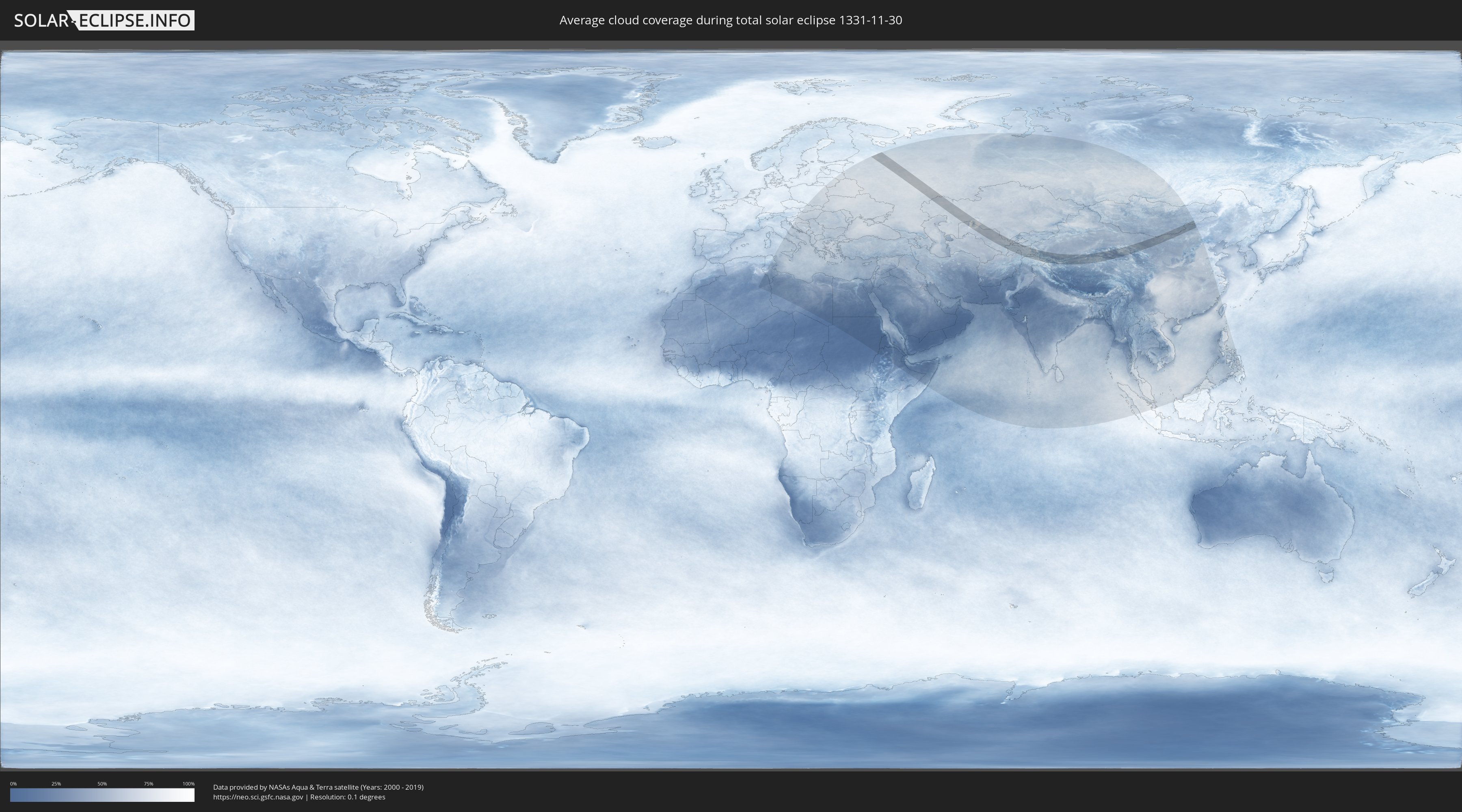
How will be the weather during the total solar eclipse on 11/30/1331?
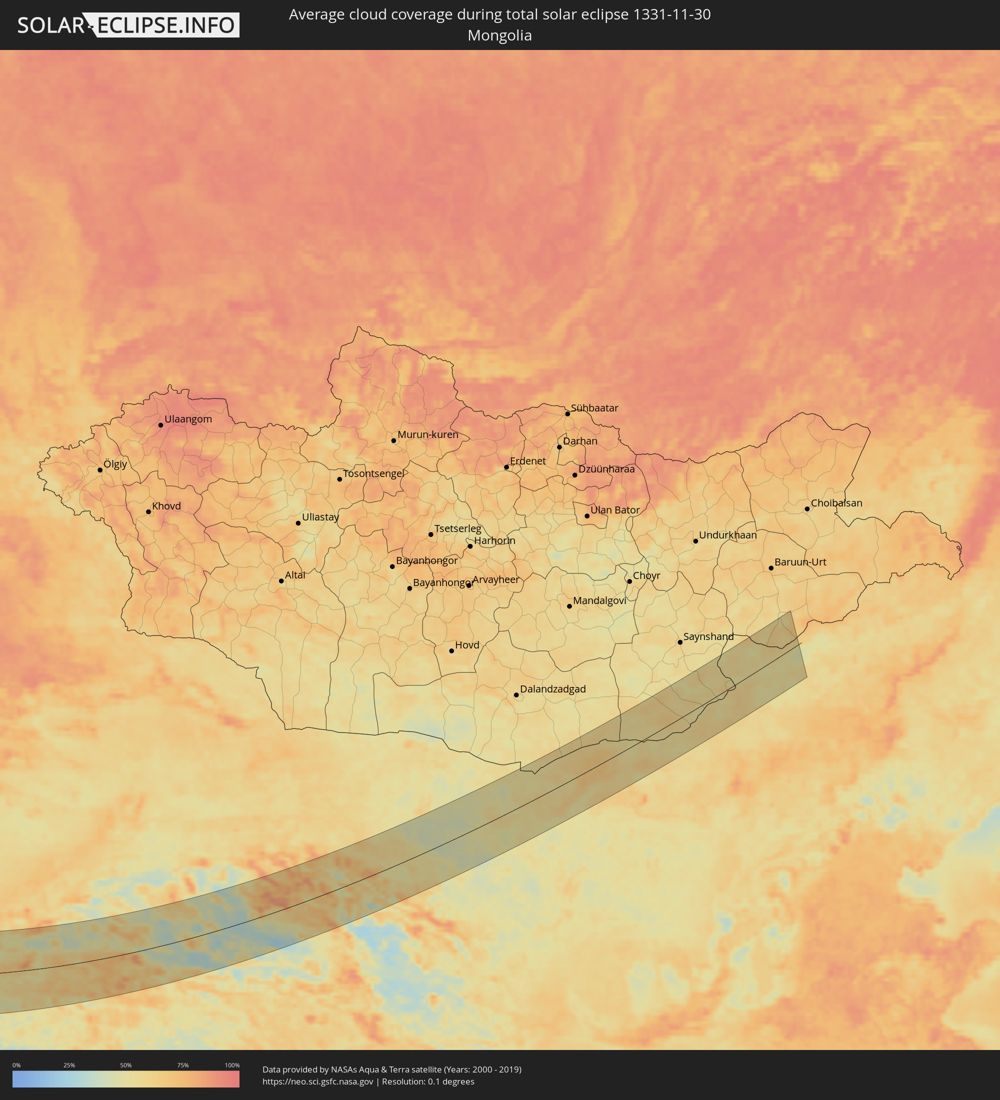
Where is the best place to see the total solar eclipse of 11/30/1331?
The following maps show the average cloud coverage for the day of the total solar eclipse.
With the help of these maps, it is possible to find the place along the eclipse path, which has the best
chance of a cloudless sky.
Nevertheless, you should consider local circumstances and inform about the weather of your chosen
observation site.
The data is provided by NASAs satellites
AQUA and TERRA.
The cloud maps are averaged over a period of 19 years (2000 - 2019).

Detailed country maps
 Russia
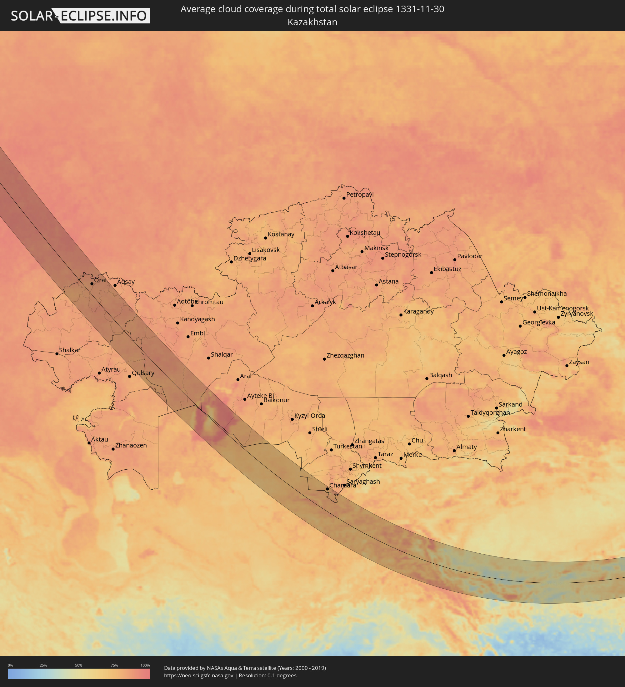 Kazakhstan
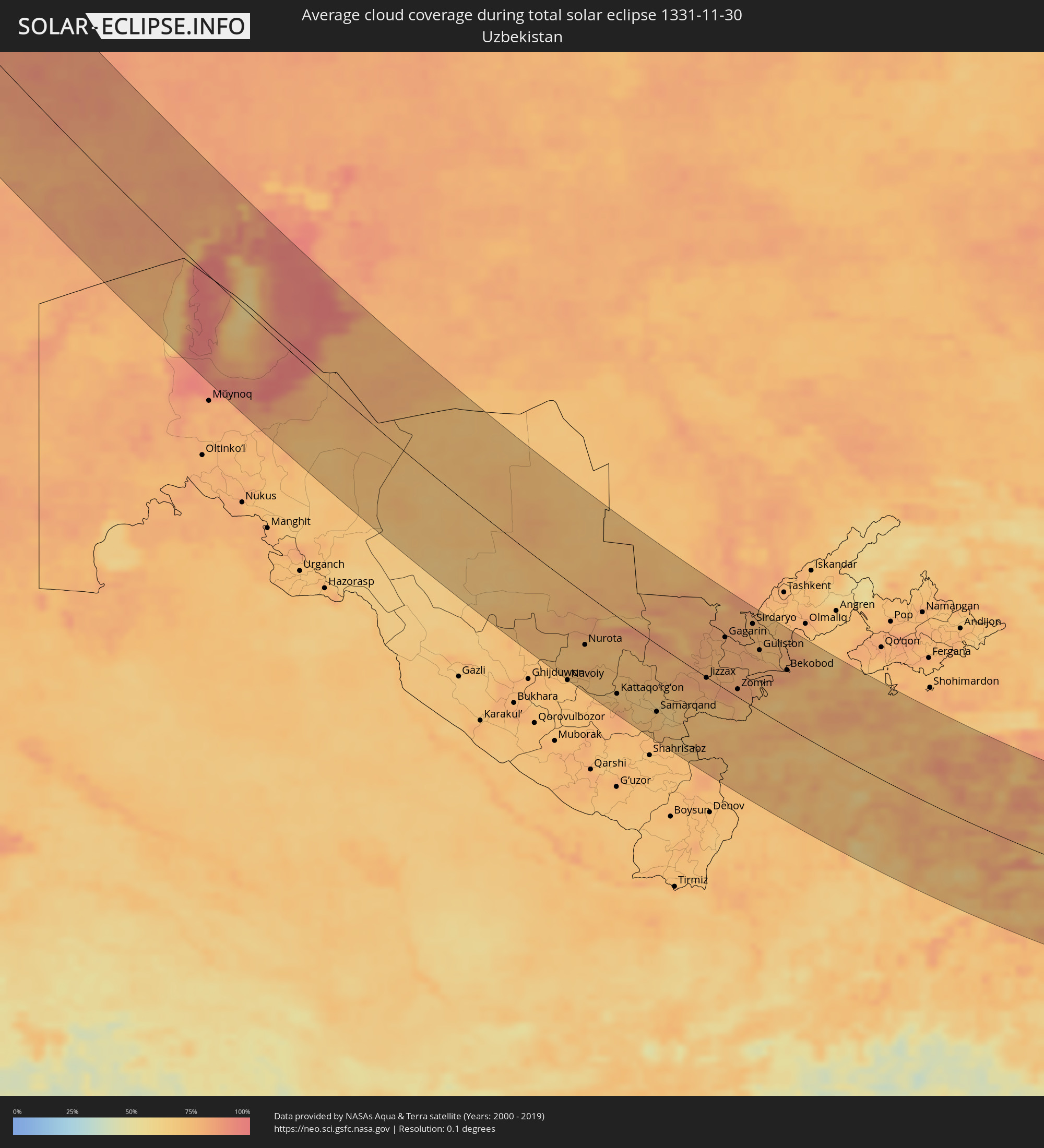 Uzbekistan
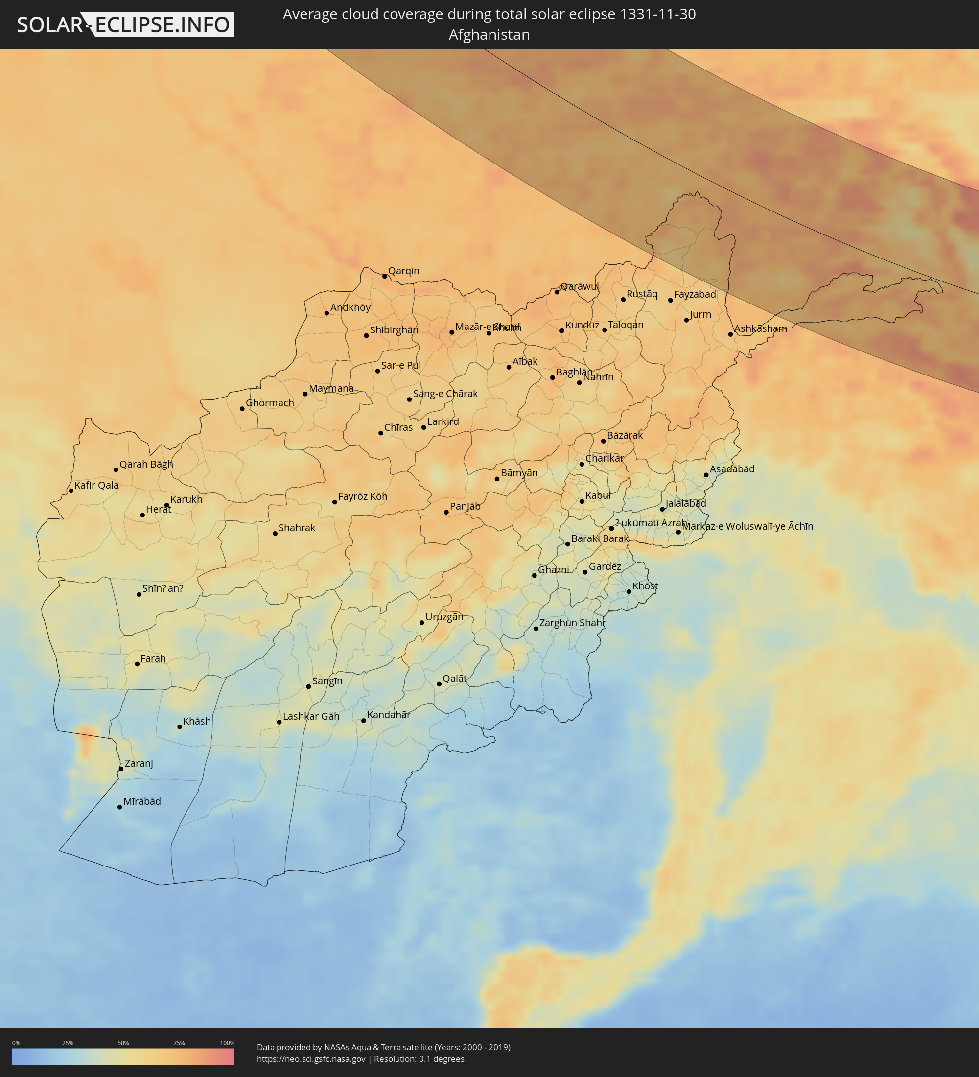 Afghanistan
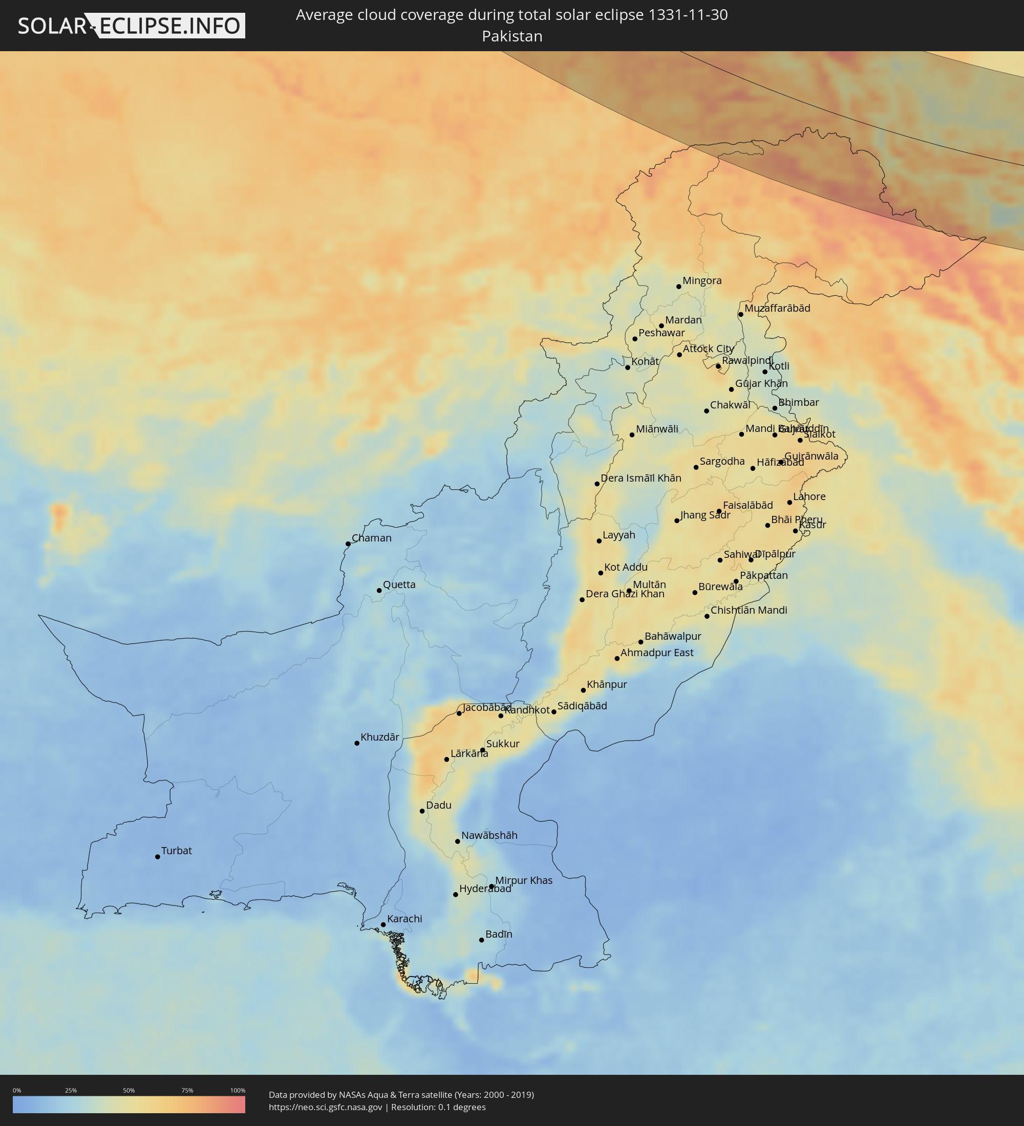 Pakistan
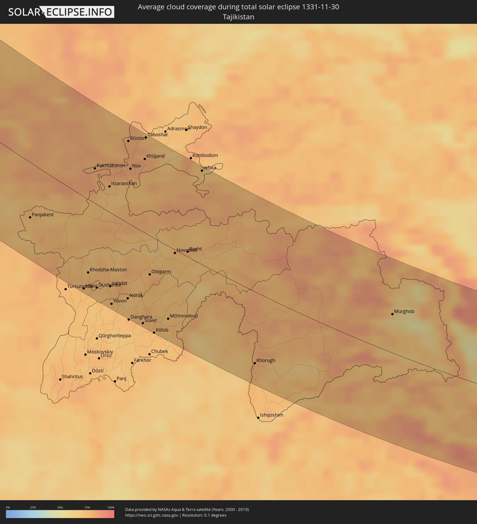 Tajikistan
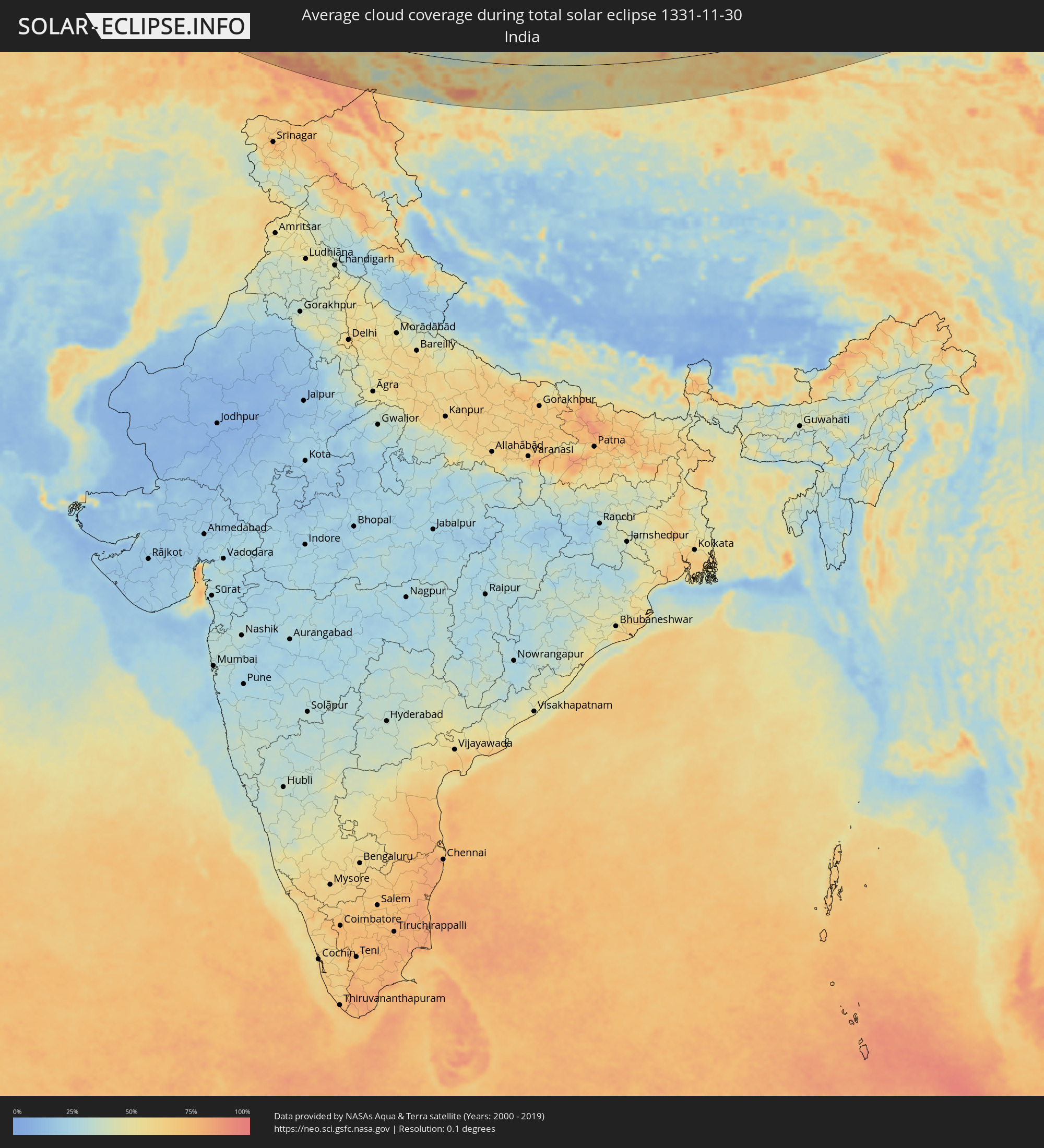 India
India
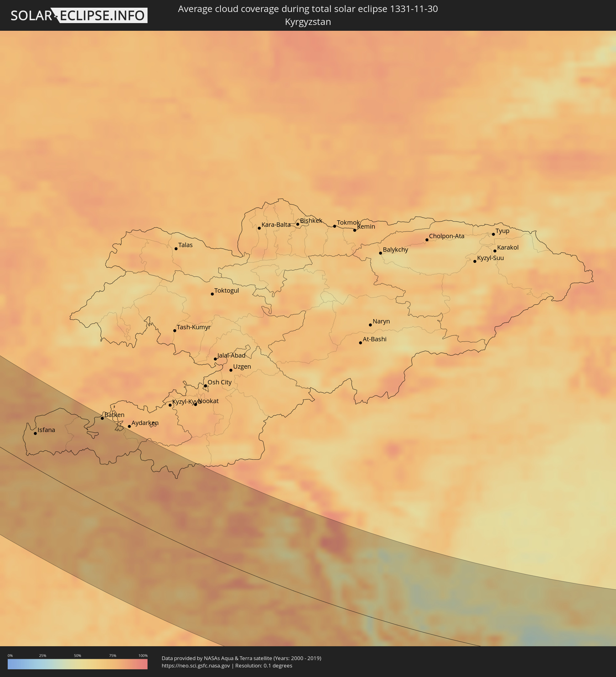 Kyrgyzstan
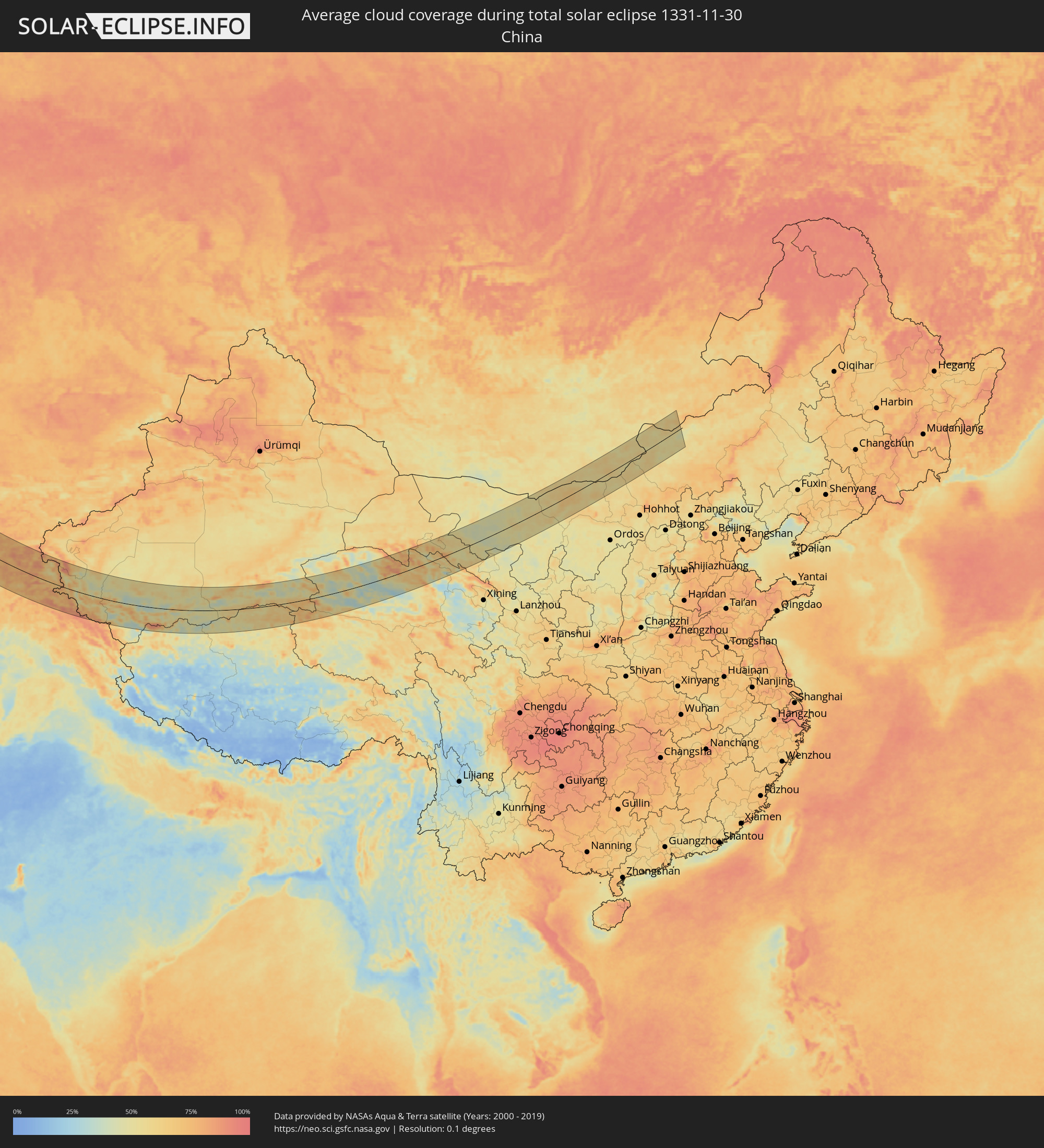 China
China
 Mongolia
Cities inside the path of the eclipse
The following table shows all locations with a population of more than 5,000 inside the eclipse path. Cities which have more than 100,000 inhabitants are marked bold. A click at the locations opens a detailed map.
| City | Type | Eclipse duration | Local time of max. eclipse | Distance to central line | Ø Cloud coverage |
|
Cherepovets, Vologda
|
total | - | 09:27:57 UTC+02:30 | 88 km | 90% |
|
Vologda, Vologda
|
total | - | 09:29:36 UTC+02:30 | 9 km | 86% |
|
Sokol, Vologda
|
total | - | 09:30:00 UTC+02:30 | 36 km | 87% |
|
Kostroma, Kostroma
|
total | - | 09:29:16 UTC+02:30 | 38 km | 92% |
|
Ivanovo, Ivanovo
|
total | - | 09:28:42 UTC+02:30 | 88 km | 91% |
|
Furmanov, Ivanovo
|
total | - | 09:29:01 UTC+02:30 | 64 km | 89% |
|
Shuya, Ivanovo
|
total | - | 09:28:57 UTC+02:30 | 78 km | 90% |
|
Vichuga, Ivanovo
|
total | - | 09:29:43 UTC+02:30 | 27 km | 88% |
|
Kineshma, Ivanovo
|
total | - | 09:30:04 UTC+02:30 | 2 km | 89% |
|
Vyazniki, Vladimir
|
total | - | 09:29:11 UTC+02:30 | 82 km | 93% |
|
Pavlovo, Nizjnij Novgorod
|
total | - | 09:29:52 UTC+02:30 | 55 km | 92% |
|
Zavolzh’ye, Nizjnij Novgorod
|
total | - | 09:30:38 UTC+02:30 | 5 km | 93% |
|
Dzerzhinsk, Nizjnij Novgorod
|
total | - | 09:30:24 UTC+02:30 | 19 km | 92% |
|
Bogorodsk, Nizjnij Novgorod
|
total | - | 09:30:22 UTC+02:30 | 25 km | 92% |
|
Novaya Balakhna, Nizjnij Novgorod
|
total | - | 09:30:43 UTC+02:30 | 5 km | 92% |
|
Arzamas, Nizjnij Novgorod
|
total | - | 09:30:11 UTC+02:30 | 58 km | 92% |
|
Nizhniy Novgorod, Nizjnij Novgorod
|
total | - | 09:31:00 UTC+02:30 | 14 km | 94% |
|
Kstovo, Nizjnij Novgorod
|
total | - | 09:31:03 UTC+02:30 | 11 km | 94% |
|
Saransk, Mordoviya
|
total | - | 09:30:44 UTC+02:30 | 75 km | 93% |
|
Shumerlya, Chuvashia
|
total | - | 09:32:51 UTC+02:30 | 78 km | 94% |
|
Alatyr’, Chuvashia
|
total | - | 09:32:37 UTC+02:30 | 41 km | 90% |
|
Kuznetsk, Penza
|
total | - | 09:31:38 UTC+02:30 | 78 km | 92% |
|
Balakovo, Saratov
|
total | - | 10:22:27 UTC+03:20 | 94 km | 88% |
|
Syzran’, Samara
|
total | - | 10:23:48 UTC+03:20 | 21 km | 91% |
|
Pugachev, Saratov
|
total | - | 10:23:37 UTC+03:20 | 43 km | 89% |
|
Tol’yatti, Samara
|
total | - | 10:25:00 UTC+03:20 | 92 km | 93% |
|
Zhigulevsk, Samara
|
total | - | 10:25:06 UTC+03:20 | 91 km | 94% |
|
Chapayevsk, Samara
|
total | - | 10:25:09 UTC+03:20 | 72 km | 93% |
|
Novokuybyshevsk, Samara
|
total | - | 10:25:29 UTC+03:20 | 93 km | 93% |
|
Kamenka, Batys Qazaqstan
|
total | - | 10:30:05 UTC+03:25 | 30 km | 81% |
|
Chapaev, Batys Qazaqstan
|
total | - | 10:30:49 UTC+03:25 | 51 km | 86% |
|
Oral, Batys Qazaqstan
|
total | - | 10:31:29 UTC+03:25 | 35 km | 84% |
|
Fedorovka, Batys Qazaqstan
|
total | - | 10:32:13 UTC+03:25 | 66 km | 85% |
|
Dzhambeyty, Batys Qazaqstan
|
total | - | 10:32:43 UTC+03:25 | 30 km | 84% |
|
Miyaly, Atyraū
|
total | - | 10:33:56 UTC+03:25 | 8 km | 82% |
|
Bayganin, Aqtöbe
|
total | - | 10:36:51 UTC+03:25 | 90 km | 85% |
|
Navoiy, Navoiy
|
total | - | 11:56:12 UTC+04:27 | 120 km | 72% |
|
Nurota, Navoiy
|
total | - | 11:56:40 UTC+04:27 | 62 km | 72% |
|
Oqtosh, Samarqand
|
total | - | 11:57:22 UTC+04:27 | 109 km | 77% |
|
Yangirabot, Navoiy
|
total | - | 11:57:24 UTC+04:27 | 98 km | 71% |
|
Payshanba, Samarqand
|
total | - | 11:57:57 UTC+04:27 | 86 km | 70% |
|
Kattaqo’rg’on, Samarqand
|
total | - | 11:58:01 UTC+04:27 | 95 km | 74% |
|
Ishtixon, Samarqand
|
total | - | 11:58:27 UTC+04:27 | 78 km | 70% |
|
Juma, Samarqand
|
total | - | 11:58:54 UTC+04:27 | 93 km | 69% |
|
Charxin, Samarqand
|
total | - | 11:59:07 UTC+04:27 | 90 km | 71% |
|
Chelak, Samarqand
|
total | - | 11:59:13 UTC+04:27 | 65 km | 66% |
|
Daxbet, Samarqand
|
total | - | 11:59:23 UTC+04:27 | 77 km | 67% |
|
Samarqand, Samarqand
|
total | - | 11:59:31 UTC+04:27 | 85 km | 72% |
|
Jomboy, Samarqand
|
total | - | 11:59:46 UTC+04:27 | 74 km | 67% |
|
Urgut, Samarqand
|
total | - | 12:00:12 UTC+04:27 | 95 km | 75% |
|
Bulung’ur, Samarqand
|
total | - | 12:00:06 UTC+04:27 | 60 km | 69% |
|
Panjakent, Viloyati Sughd
|
total | - | 12:08:12 UTC+04:35 | 70 km | 72% |
|
Jizzax, Jizzax
|
total | - | 12:01:04 UTC+04:27 | 1 km | 83% |
|
Paxtakor, Jizzax
|
total | - | 12:01:13 UTC+04:27 | 23 km | 77% |
|
Chardara, Ongtüstik Qazaqstan
|
total | - | 11:54:49 UTC+04:21 | 111 km | 75% |
|
Dŭstlik, Jizzax
|
total | - | 12:01:17 UTC+04:27 | 46 km | 77% |
|
Gagarin, Jizzax
|
total | - | 12:01:29 UTC+04:27 | 65 km | 80% |
|
Shahrinav
|
total | - | 12:10:07 UTC+04:35 | 125 km | 73% |
|
Asyqata, Ongtüstik Qazaqstan
|
total | - | 11:55:45 UTC+04:21 | 96 km | 81% |
|
Zomin, Jizzax
|
total | - | 12:02:15 UTC+04:27 | 10 km | 81% |
|
Dashtobod, Jizzax
|
total | - | 12:02:22 UTC+04:27 | 30 km | 83% |
|
Atakent, Ongtüstik Qazaqstan
|
total | - | 11:56:03 UTC+04:21 | 98 km | 81% |
|
Slavyanka, Ongtüstik Qazaqstan
|
total | - | 11:56:12 UTC+04:21 | 83 km | 80% |
|
Hisor, Republican Subordination
|
total | - | 12:10:35 UTC+04:35 | 120 km | 73% |
|
Khodzha-Maston
|
total | - | 12:10:37 UTC+04:35 | 95 km | 77% |
|
Sirdaryo, Sirdaryo
|
total | - | 12:02:22 UTC+04:27 | 105 km | 75% |
|
Pakhtakoron, Viloyati Sughd
|
total | - | 12:10:10 UTC+04:35 | 45 km | 79% |
|
Chinoz, Toshkent
|
total | - | 12:02:31 UTC+04:27 | 118 km | 75% |
|
Dushanbe, Dushanbe
|
total | - | 12:11:02 UTC+04:35 | 109 km | 72% |
|
Guliston, Sirdaryo
|
total | - | 12:02:46 UTC+04:27 | 77 km | 78% |
|
Boshkengash, Dushanbe
|
total | - | 12:11:08 UTC+04:35 | 114 km | 72% |
|
Yangiyer, Sirdaryo
|
total | - | 12:02:57 UTC+04:27 | 59 km | 79% |
|
Istaravshan, Viloyati Sughd
|
total | - | 12:10:48 UTC+04:35 | 33 km | 70% |
|
Vahdat, Republican Subordination
|
total | - | 12:11:31 UTC+04:35 | 97 km | 75% |
|
Yovon, Khatlon
|
total | - | 12:11:41 UTC+04:35 | 119 km | 71% |
|
Bo‘ka, Toshkent
|
total | - | 12:03:26 UTC+04:27 | 126 km | 75% |
|
Bekobod, Toshkent
|
total | - | 12:03:52 UTC+04:27 | 74 km | 81% |
|
Norak, Khatlon
|
total | - | 12:12:14 UTC+04:35 | 100 km | 68% |
|
Bŭston, Viloyati Sughd
|
total | - | 12:11:10 UTC+04:35 | 105 km | 81% |
|
Nov, Viloyati Sughd
|
total | - | 12:11:25 UTC+04:35 | 72 km | 80% |
|
Proletar, Viloyati Sughd
|
total | - | 12:11:41 UTC+04:35 | 79 km | 79% |
|
Isfana, Batken
|
total | - | 12:35:06 UTC+04:58 | 49 km | 73% |
|
Suluktu, Batken
|
total | - | 12:35:08 UTC+04:58 | 60 km | 72% |
|
Sovet, Khatlon
|
total | - | 12:12:58 UTC+04:35 | 122 km | 74% |
|
Khŭjand, Viloyati Sughd
|
total | - | 12:11:52 UTC+04:35 | 95 km | 80% |
|
Taboshar, Viloyati Sughd
|
total | - | 12:11:45 UTC+04:35 | 124 km | 74% |
|
Chkalov, Viloyati Sughd
|
total | - | 12:12:02 UTC+04:35 | 94 km | 75% |
|
Konsoy, Viloyati Sughd
|
total | - | 12:11:55 UTC+04:35 | 119 km | 75% |
|
Obigarm
|
total | - | 12:12:51 UTC+04:35 | 51 km | 77% |
|
Kŭlob, Khatlon
|
total | - | 12:13:27 UTC+04:35 | 127 km | 73% |
|
Roghun
|
total | - | 12:13:09 UTC+04:35 | 38 km | 76% |
|
Mŭ’minobod, Khatlon
|
total | - | 12:13:52 UTC+04:35 | 98 km | 73% |
|
Novobod
|
total | - | 12:13:36 UTC+04:35 | 4 km | 71% |
|
Rasht
|
total | - | 12:14:03 UTC+04:35 | 7 km | 72% |
|
Isfara, Viloyati Sughd
|
total | - | 12:13:57 UTC+04:35 | 124 km | 71% |
|
Batken, Batken
|
total | - | 12:37:35 UTC+04:58 | 126 km | 69% |
|
Khorugh, Gorno-Badakhshan
|
total | - | 12:17:25 UTC+04:35 | 99 km | 77% |
|
Khandūd, Badakhshan
|
total | - | 11:44:11 UTC+04:00 | 126 km | 67% |
|
Murghob, Gorno-Badakhshan
|
total | - | 12:22:01 UTC+04:35 | 55 km | 59% |
|
Zangguy, Xinjiang Uyghur Autonomous Region
|
total | - | 15:57:28 UTC+08:00 | 85 km | 49% |
|
Hotan, Xinjiang Uyghur Autonomous Region
|
total | - | 16:00:00 UTC+08:00 | 84 km | 64% |
|
Zhangye, Gansu
|
total | - | 16:32:07 UTC+08:00 | 29 km | 47% |
|
Erenhot, Inner Mongolia
|
total | - | 16:37:03 UTC+08:00 | 17 km | 59% |