Hybrid solar eclipse of 05/25/1351
| Day of week: | Tuesday |
| Maximum duration of eclipse: | 00m09s |
| Maximum width of eclipse path: | 6 km |
| Saros cycle: | 117 |
| Coverage: | 100% |
| Magnitude: | 1.0016 |
| Gamma: | 0.2015 |
Wo kann man die Sonnenfinsternis vom 05/25/1351 sehen?
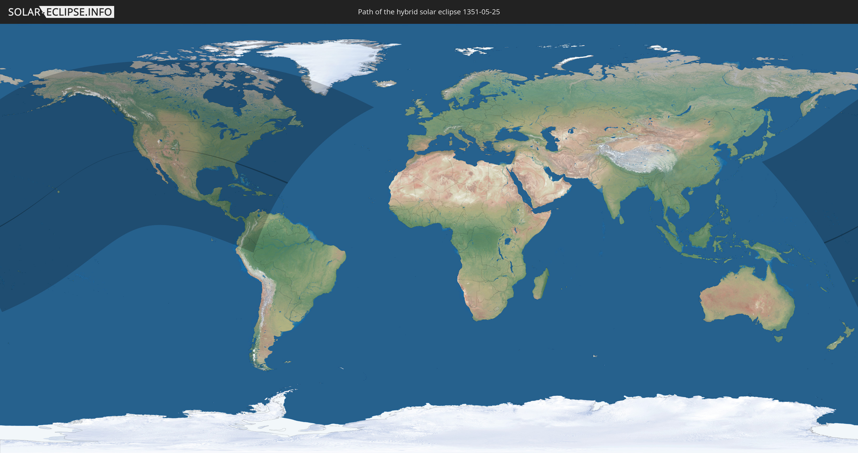
Die Sonnenfinsternis am 05/25/1351 kann man in 48 Ländern als partielle Sonnenfinsternis beobachten.
Der Finsternispfad verläuft durch 2 Länder. Nur in diesen Ländern ist sie als hybrid Sonnenfinsternis zu sehen.
In den folgenden Ländern ist die Sonnenfinsternis hybrid zu sehen
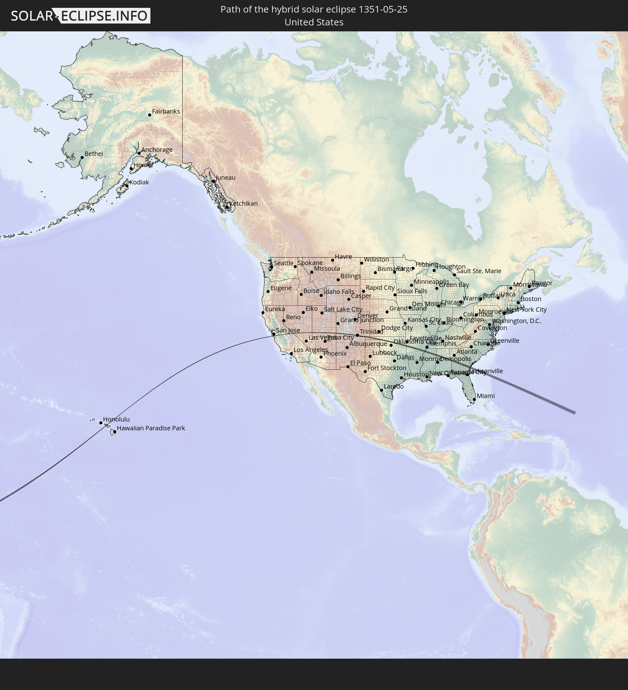 United States
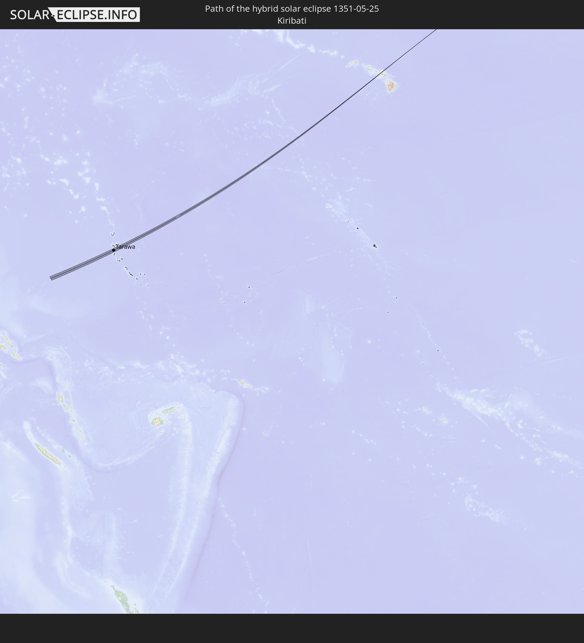 Kiribati
In den folgenden Ländern ist die Sonnenfinsternis partiell zu sehen
 Fiji
Fiji
 United States
 New Zealand
 United States Minor Outlying Islands
 Wallis and Futuna
 Tonga
Tonga
 Kiribati
 Samoa
Samoa
 Tokelau
 American Samoa
 Niue
Niue
 Cook Islands
 French Polynesia
 Canada
 Mexico
 Greenland
 Guatemala
 Ecuador
 El Salvador
 Honduras
 Belize
 Nicaragua
 Costa Rica
 Cuba
Cuba
 Panama
 Colombia
 Cayman Islands
 Peru
Peru
 The Bahamas
 Jamaica
 Haiti
Haiti
 Venezuela
 Turks and Caicos Islands
 Dominican Republic
 Aruba
Aruba
 Puerto Rico
 United States Virgin Islands
 Bermuda
 British Virgin Islands
 Anguilla
 Collectivity of Saint Martin
 Saint Barthélemy
 Saint Pierre and Miquelon
 Japan
Japan
 Federated States of Micronesia
 Marshall Islands
 Nauru
Nauru
 Tuvalu
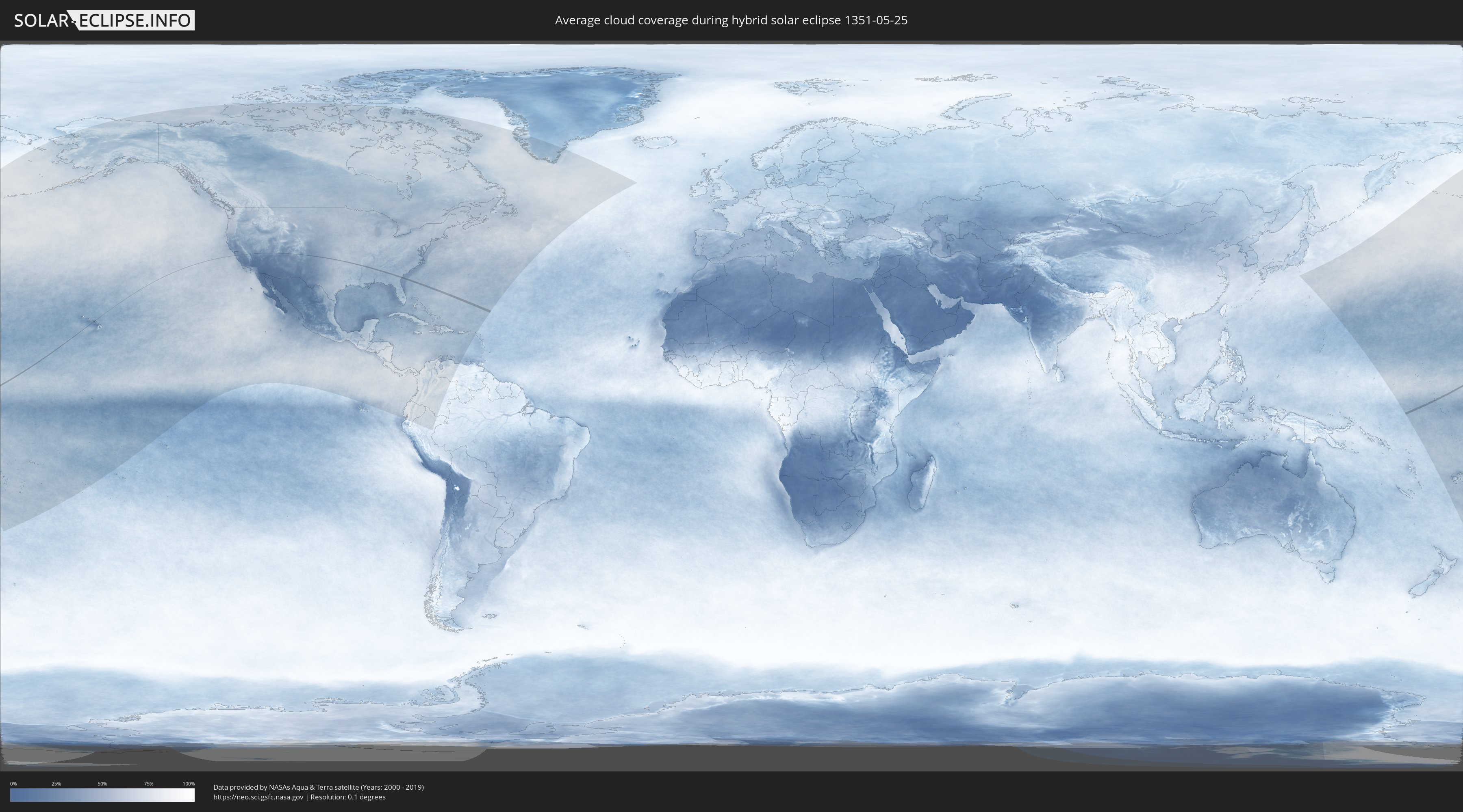
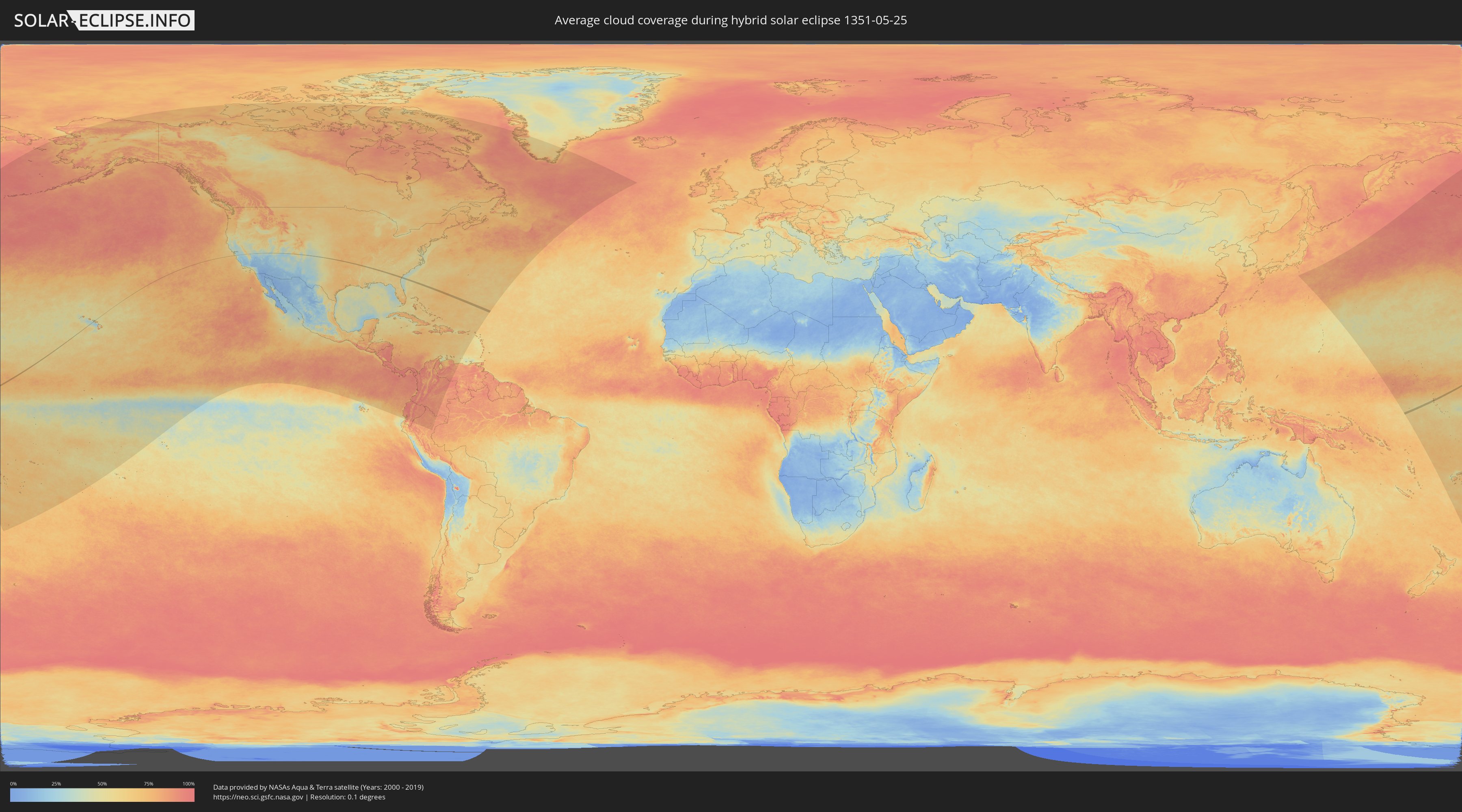
How will be the weather during the hybrid solar eclipse on 05/25/1351?
Where is the best place to see the hybrid solar eclipse of 05/25/1351?
The following maps show the average cloud coverage for the day of the hybrid solar eclipse.
With the help of these maps, it is possible to find the place along the eclipse path, which has the best
chance of a cloudless sky.
Nevertheless, you should consider local circumstances and inform about the weather of your chosen
observation site.
The data is provided by NASAs satellites
AQUA and TERRA.
The cloud maps are averaged over a period of 19 years (2000 - 2019).
Detailed country maps
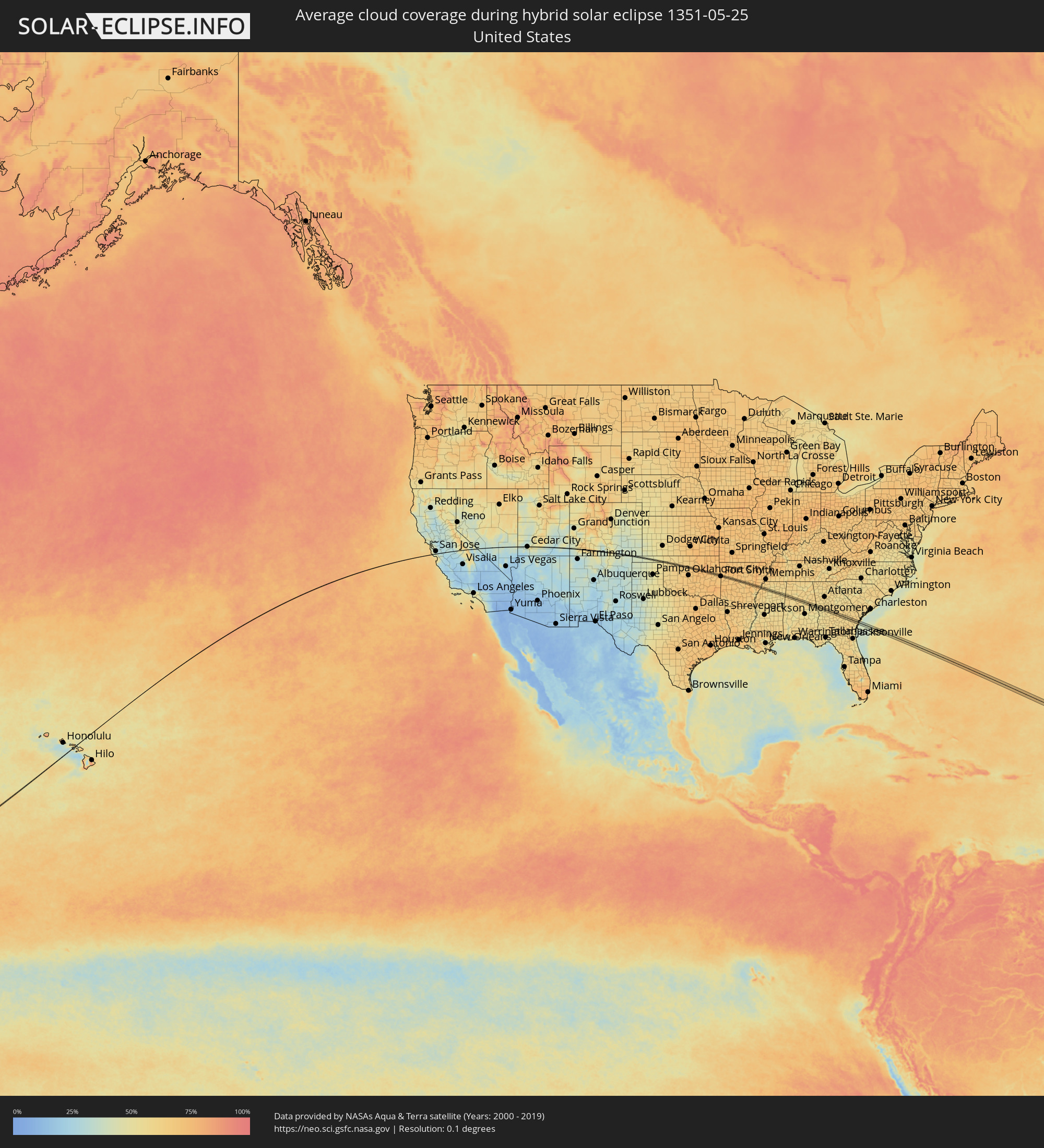 United States
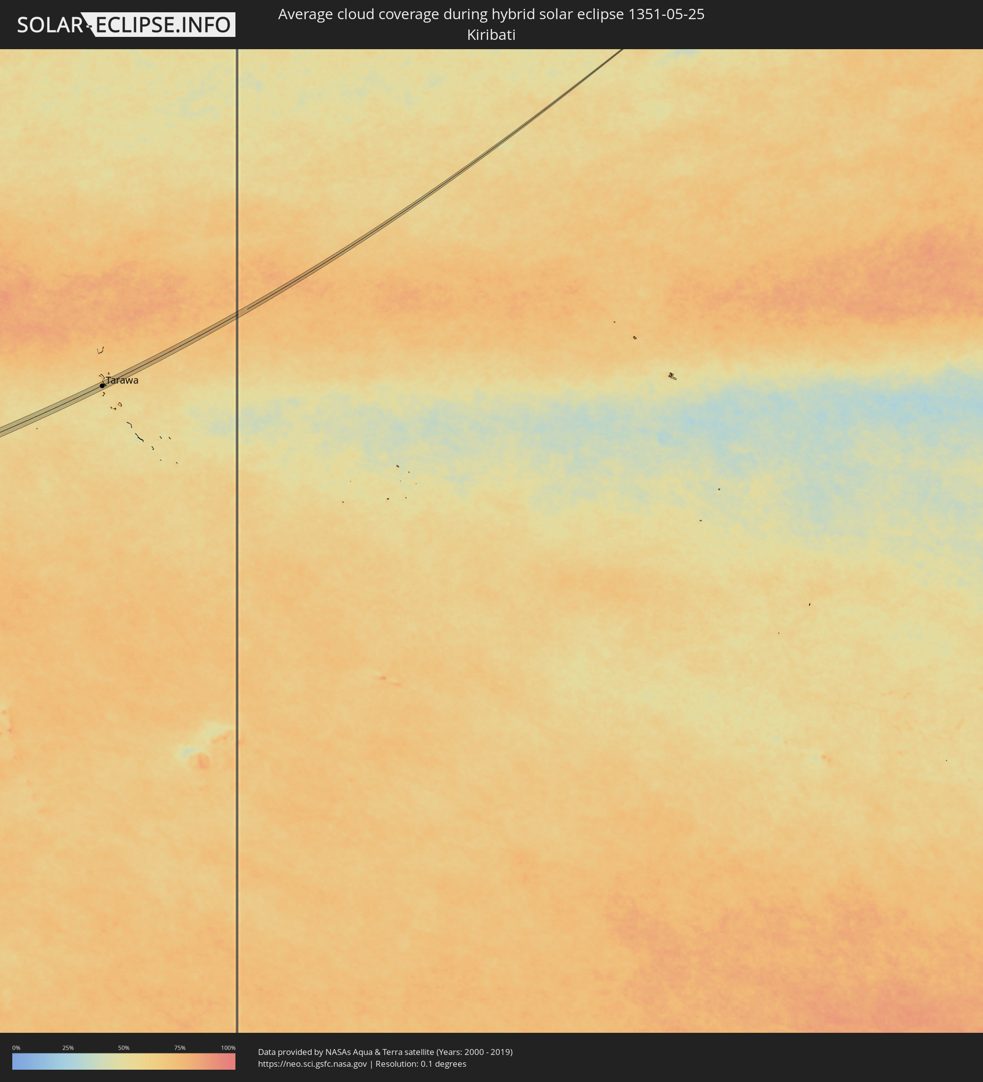 Kiribati
Cities inside the path of the eclipse
The following table shows all locations with a population of more than 5,000 inside the eclipse path. Cities which have more than 100,000 inhabitants are marked bold. A click at the locations opens a detailed map.
| City | Type | Eclipse duration | Local time of max. eclipse | Distance to central line | Ø Cloud coverage |
|
Gustine, California
|
total | - | 13:23:07 UTC-08:00 | 0 km | 28% |
|
Cedar City, Utah
|
annular | - | 14:40:11 UTC-07:00 | 1 km | 36% |
|
Trinidad, Colorado
|
annular | - | 14:55:59 UTC-07:00 | 0 km | 41% |
|
Woodward, Oklahoma
|
annular | - | 16:04:10 UTC-06:00 | 0 km | 56% |
|
Cushing, Oklahoma
|
annular | - | 16:07:59 UTC-06:00 | 4 km | 72% |
|
Sallisaw, Oklahoma
|
annular | - | 16:10:50 UTC-06:00 | 8 km | 69% |
|
Fort Smith, Arkansas
|
annular | - | 16:11:20 UTC-06:00 | 6 km | 70% |
|
Van Buren, Arkansas
|
annular | - | 16:11:21 UTC-06:00 | 0 km | 69% |
|
Alma, Arkansas
|
annular | - | 16:11:27 UTC-06:00 | 8 km | 70% |
|
Morrilton, Arkansas
|
annular | - | 16:13:21 UTC-06:00 | 10 km | 66% |
|
Jacksonville, Arkansas
|
annular | - | 16:14:17 UTC-06:00 | 4 km | 65% |
|
Cabot, Arkansas
|
annular | - | 16:14:16 UTC-06:00 | 10 km | 65% |
|
West Helena, Arkansas
|
annular | - | 16:16:01 UTC-06:00 | 2 km | 59% |
|
Helena, Arkansas
|
annular | - | 16:16:05 UTC-06:00 | 1 km | 62% |
|
Helena-West Helena, Arkansas
|
annular | - | 16:16:05 UTC-06:00 | 1 km | 62% |
|
Batesville, Mississippi
|
annular | - | 16:16:54 UTC-06:00 | 4 km | 59% |
|
Amory, Mississippi
|
annular | - | 16:18:30 UTC-06:00 | 3 km | 54% |
|
Hueytown, Alabama
|
annular | - | 16:20:13 UTC-06:00 | 8 km | 60% |
|
Pleasant Grove, Alabama
|
annular | - | 16:20:12 UTC-06:00 | 3 km | 60% |
|
Bessemer, Alabama
|
annular | - | 16:20:18 UTC-06:00 | 12 km | 61% |
|
Fairfield, Alabama
|
annular | - | 16:20:15 UTC-06:00 | 2 km | 62% |
|
Midfield, Alabama
|
annular | - | 16:20:17 UTC-06:00 | 4 km | 62% |
|
Forestdale, Alabama
|
annular | - | 16:20:11 UTC-06:00 | 8 km | 61% |
|
Hoover, Alabama
|
annular | - | 16:20:24 UTC-06:00 | 7 km | 62% |
|
Birmingham, Alabama
|
annular | - | 16:20:18 UTC-06:00 | 5 km | 61% |
|
Homewood, Alabama
|
annular | - | 16:20:21 UTC-06:00 | 0 km | 61% |
|
Vestavia Hills, Alabama
|
annular | - | 16:20:23 UTC-06:00 | 2 km | 62% |
|
Tarrant, Alabama
|
annular | - | 16:20:16 UTC-06:00 | 13 km | 63% |
|
Mountain Brook, Alabama
|
annular | - | 16:20:22 UTC-06:00 | 5 km | 61% |
|
Cahaba Heights, Alabama
|
annular | - | 16:20:25 UTC-06:00 | 1 km | 60% |
|
Irondale, Alabama
|
annular | - | 16:20:21 UTC-06:00 | 10 km | 60% |
|
Meadowbrook, Alabama
|
annular | - | 16:20:30 UTC-06:00 | 4 km | 58% |
|
Lake Purdy, Alabama
|
annular | - | 16:20:29 UTC-06:00 | 1 km | 58% |
|
Brook Highland, Alabama
|
annular | - | 16:20:29 UTC-06:00 | 1 km | 58% |
|
Chelsea, Alabama
|
annular | - | 16:20:37 UTC-06:00 | 8 km | 57% |
|
Childersburg, Alabama
|
annular | - | 16:20:53 UTC-06:00 | 6 km | 53% |
|
Roanoke, Alabama
|
annular | - | 16:21:43 UTC-06:00 | 11 km | 56% |
|
Lanett, Alabama
|
annular | - | 16:22:07 UTC-06:00 | 13 km | 55% |
|
La Grange, Georgia
|
annular | - | 17:22:03 UTC-05:00 | 10 km | 57% |
|
Fort Valley, Georgia
|
annular | - | 17:23:17 UTC-05:00 | 3 km | 59% |
|
Perry, Georgia
|
annular | - | 17:23:28 UTC-05:00 | 8 km | 58% |
|
Centerville, Georgia
|
annular | - | 17:23:20 UTC-05:00 | 11 km | 61% |
|
Warner Robins, Georgia
|
annular | - | 17:23:23 UTC-05:00 | 12 km | 60% |
|
Cochran, Georgia
|
annular | - | 17:23:46 UTC-05:00 | 3 km | 63% |
|
Vidalia, Georgia
|
annular | - | 17:24:30 UTC-05:00 | 11 km | 58% |
|
Hinesville, Georgia
|
annular | - | 17:25:18 UTC-05:00 | 0 km | 62% |
|
Betio Village, Gilbert Islands
|
annular | - | 06:57:29 UTC+12:00 | 1 km | 64% |
|
Tarawa, Gilbert Islands
|
annular | - | 06:57:27 UTC+12:00 | 6 km | 58% |
|
Bikenibeu Village, Gilbert Islands
|
annular | - | 06:57:29 UTC+12:00 | 10 km | 66% |