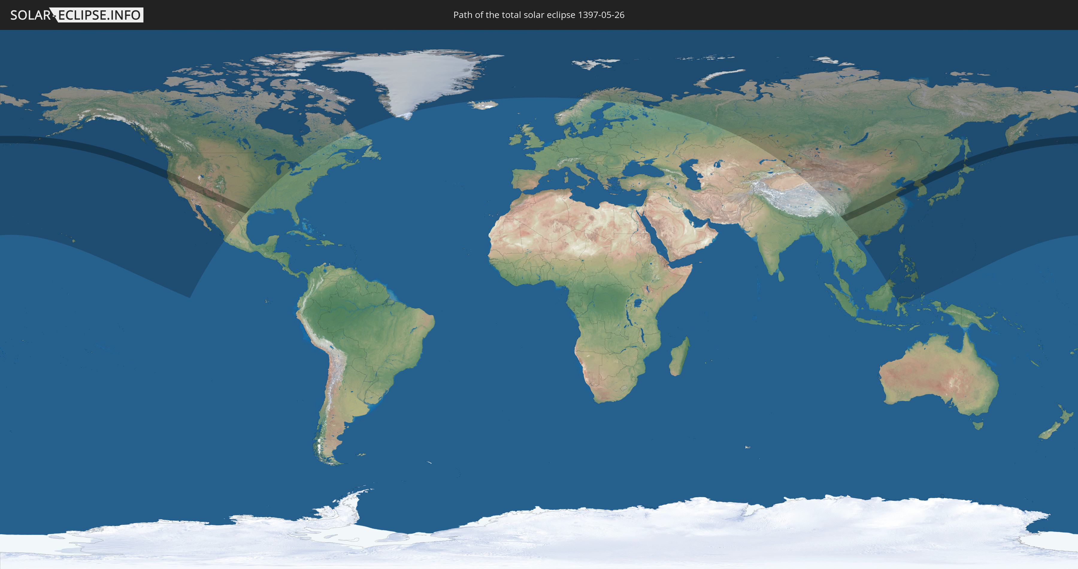
Total solar eclipse of 05/26/1397
| Day of week: | Friday |
| Maximum duration of eclipse: | 05m01s |
| Maximum width of eclipse path: | 263 km |
| Saros cycle: | 108 |
| Coverage: | 100% |
| Magnitude: | 1.0692 |
| Gamma: | 0.5101 |
Wo kann man die Sonnenfinsternis vom 05/26/1397 sehen?
Die Sonnenfinsternis am 05/26/1397 kann man in 28 Ländern als partielle Sonnenfinsternis beobachten.
Der Finsternispfad verläuft durch 6 Länder. Nur in diesen Ländern ist sie als total Sonnenfinsternis zu sehen.
In den folgenden Ländern ist die Sonnenfinsternis total zu sehen
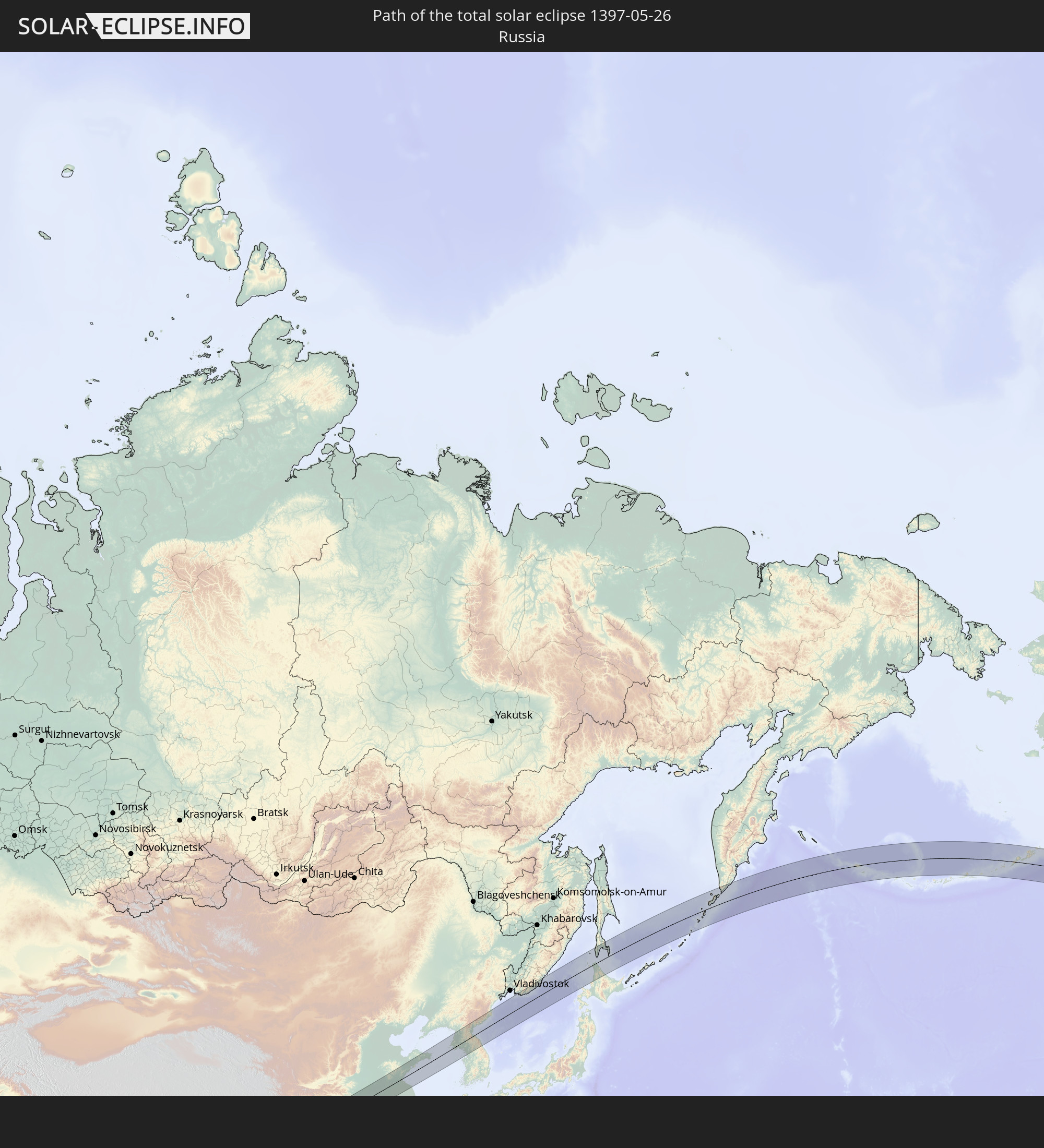 Russia
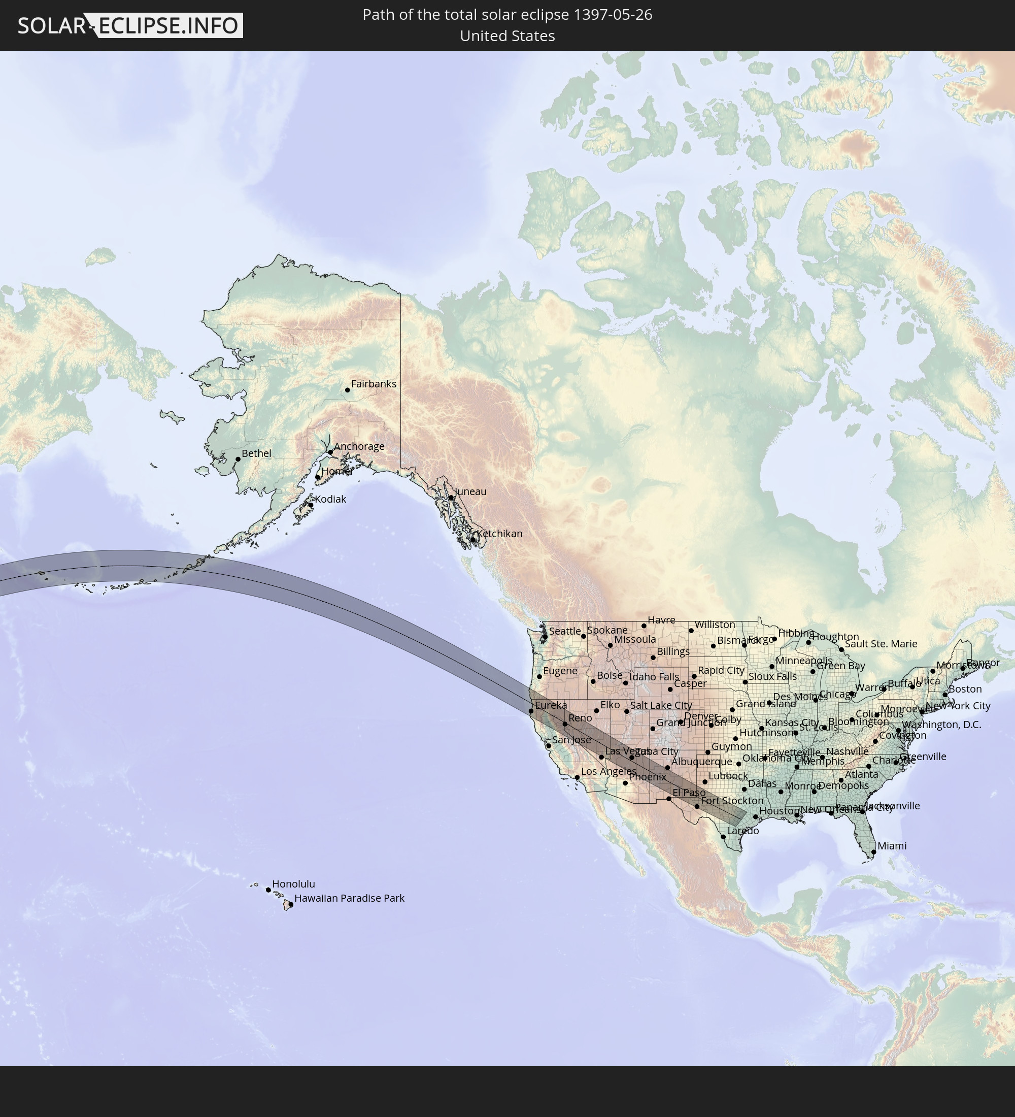 United States
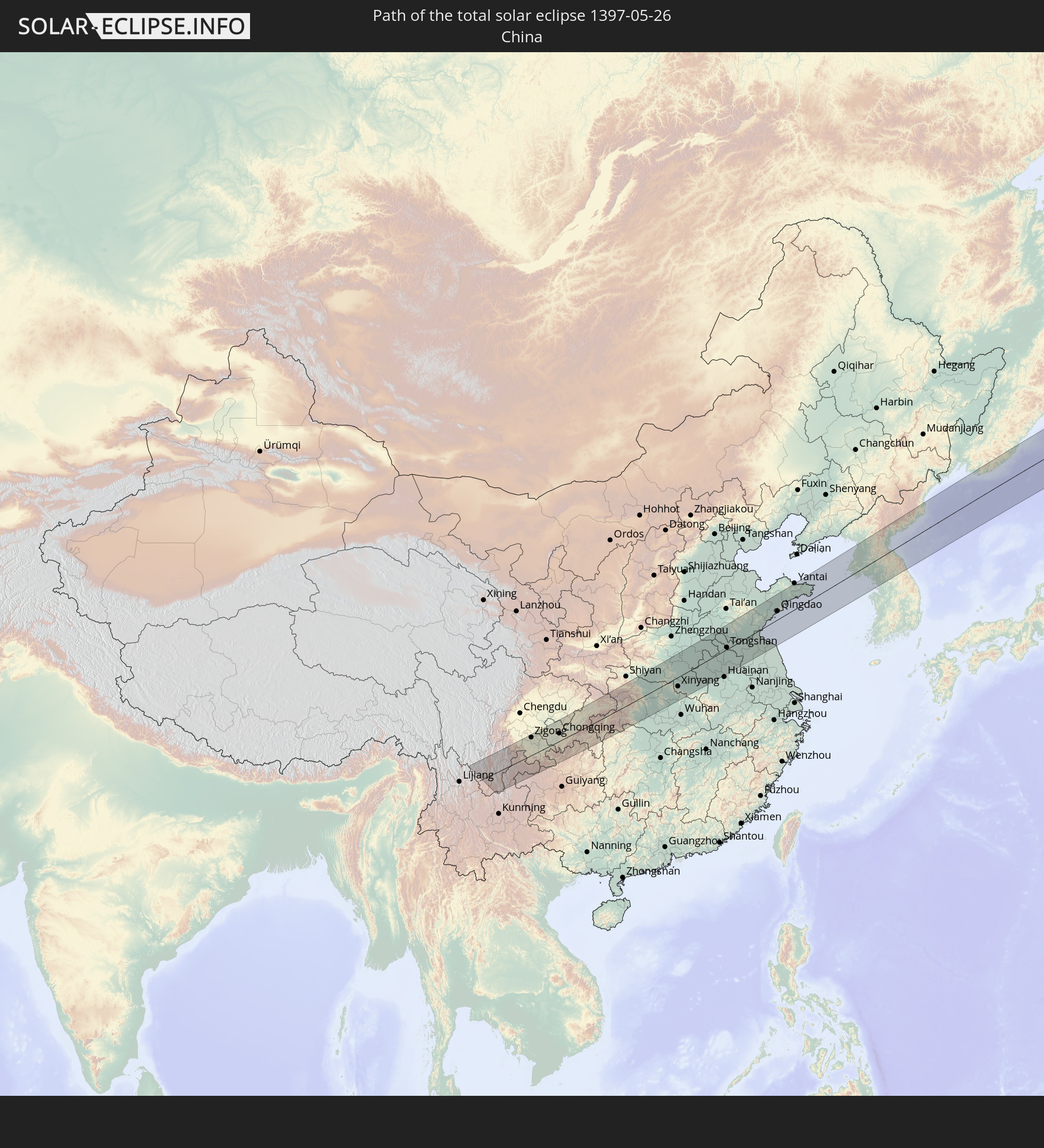 China
China
 Japan
Japan
 North Korea
 South Korea
In den folgenden Ländern ist die Sonnenfinsternis partiell zu sehen
 Russia
 United States
 United States Minor Outlying Islands
 Canada
 Mexico
 Greenland
 Iceland
 Svalbard and Jan Mayen
 Norway
 Sweden
 Finland
 Kazakhstan
 China
China
 Mongolia
 Indonesia
 Malaysia
 Vietnam
 Macau
Macau
 Hong Kong
 Taiwan
 Philippines
 Japan
Japan
 North Korea
 South Korea
 Palau
Palau
 Federated States of Micronesia
 Guam
Guam
 Northern Mariana Islands
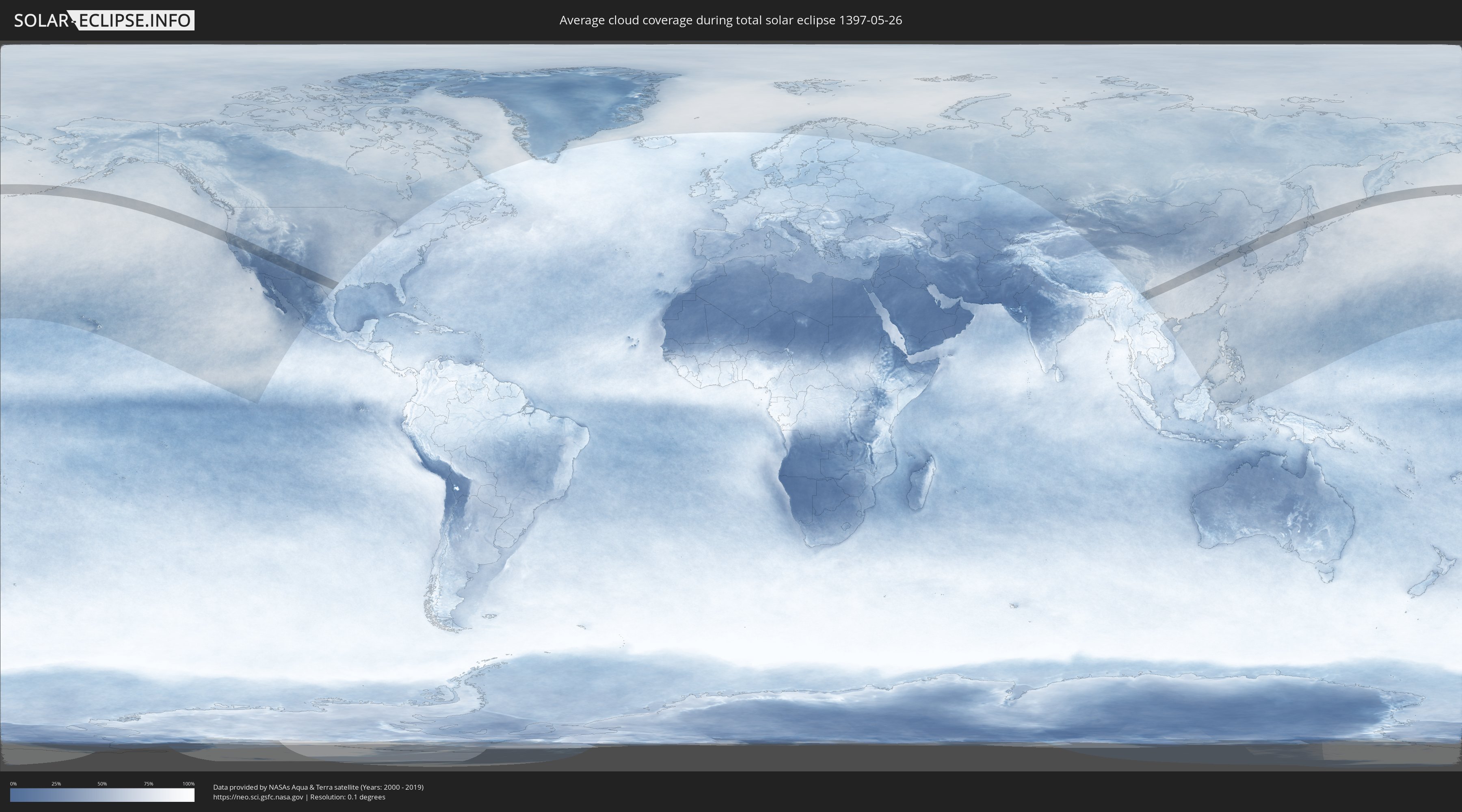
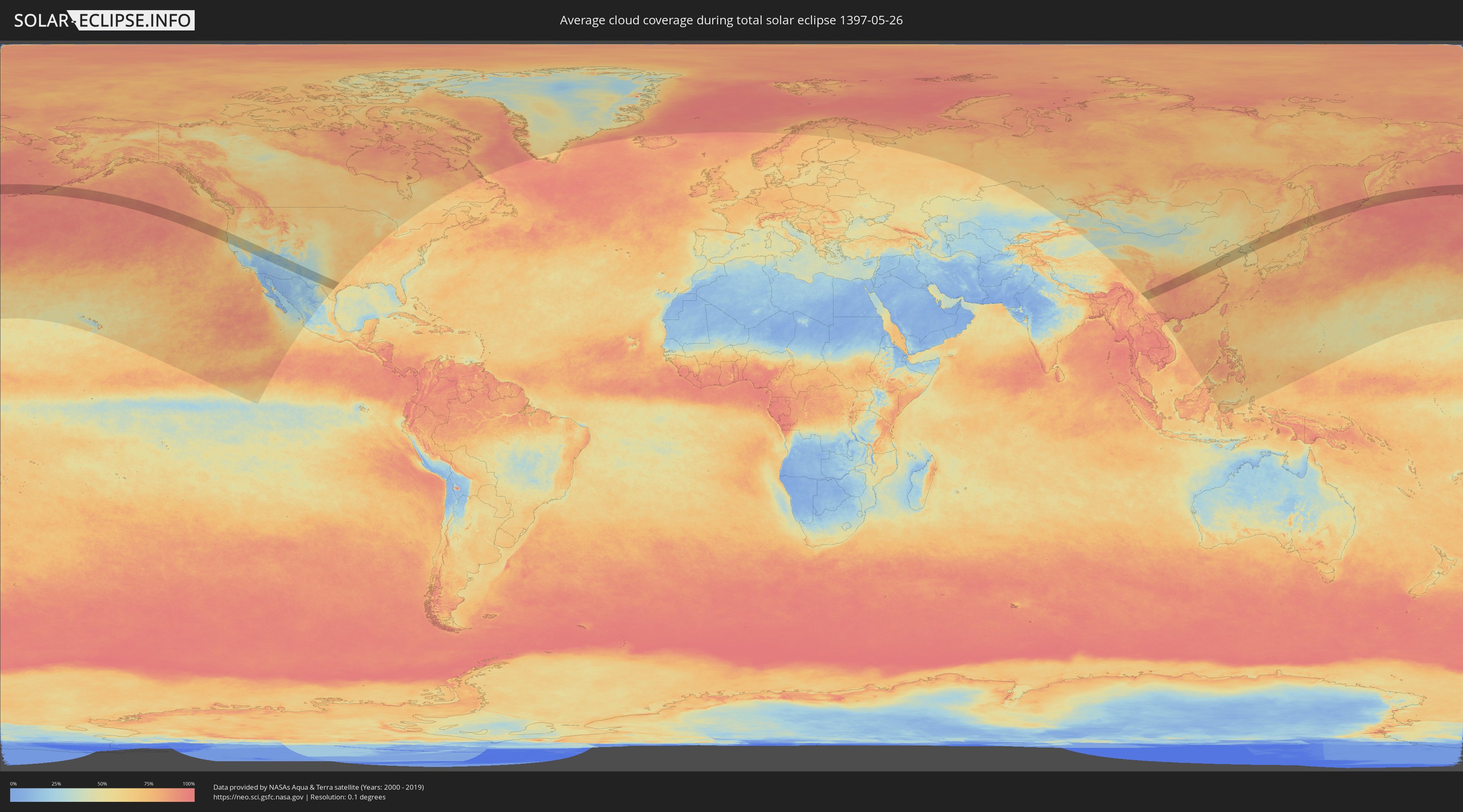
How will be the weather during the total solar eclipse on 05/26/1397?
Where is the best place to see the total solar eclipse of 05/26/1397?
The following maps show the average cloud coverage for the day of the total solar eclipse.
With the help of these maps, it is possible to find the place along the eclipse path, which has the best
chance of a cloudless sky.
Nevertheless, you should consider local circumstances and inform about the weather of your chosen
observation site.
The data is provided by NASAs satellites
AQUA and TERRA.
The cloud maps are averaged over a period of 19 years (2000 - 2019).
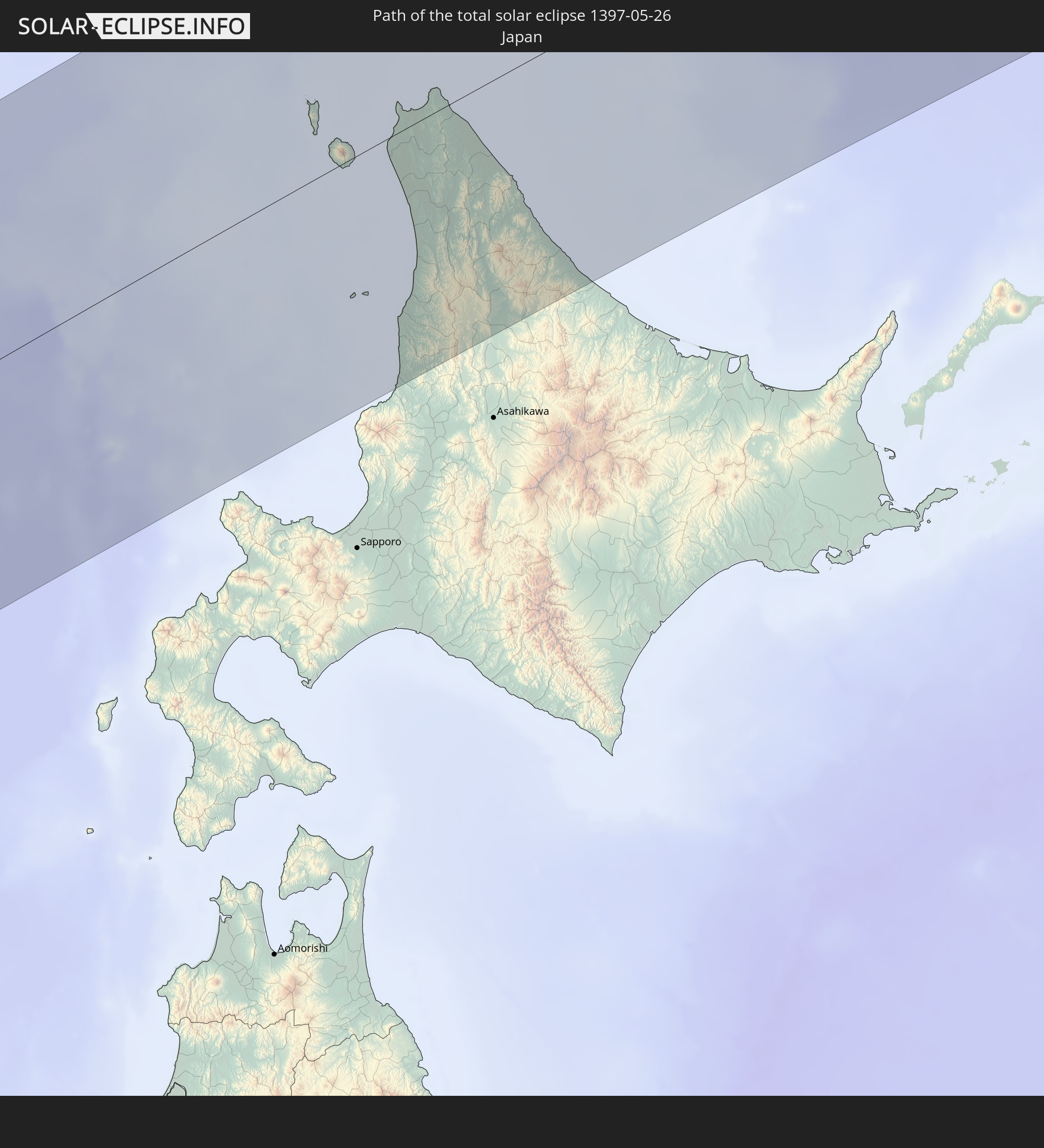
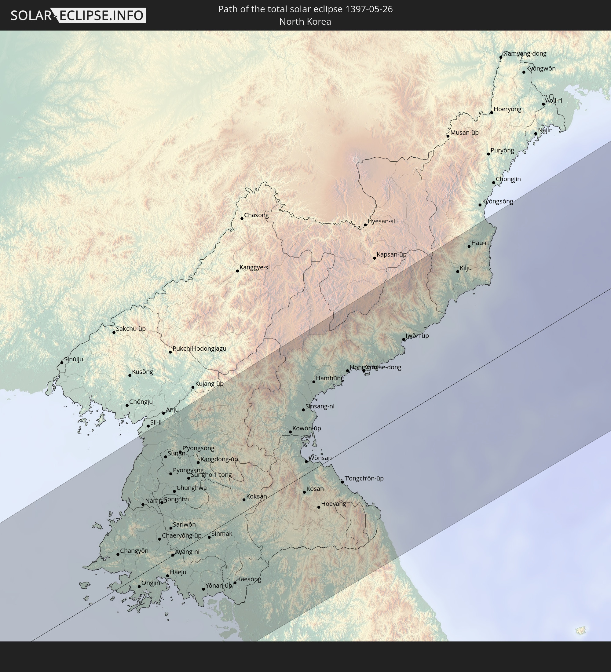
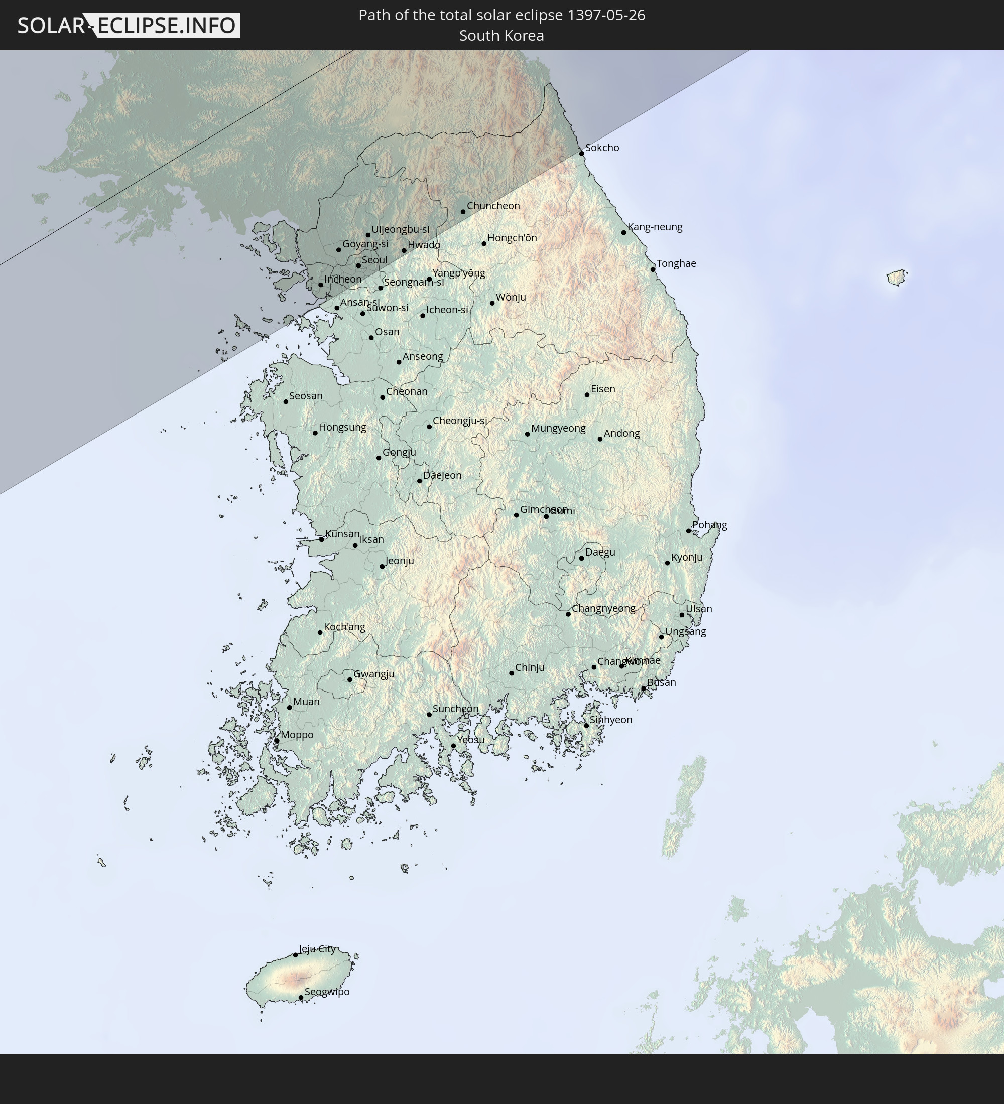
Detailed country maps
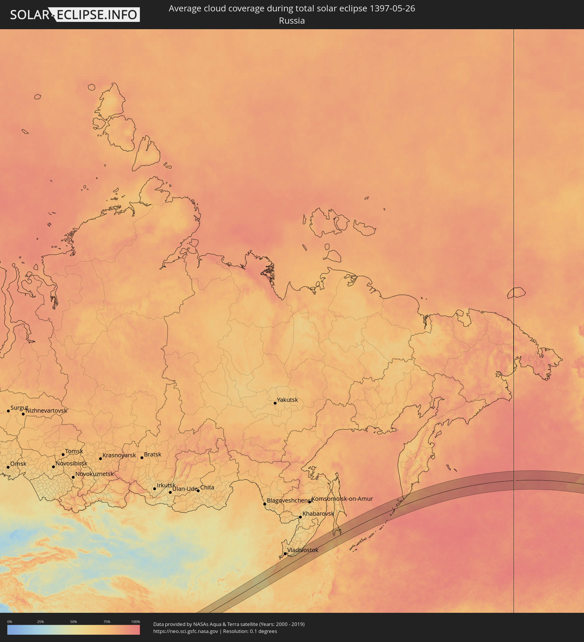 Russia
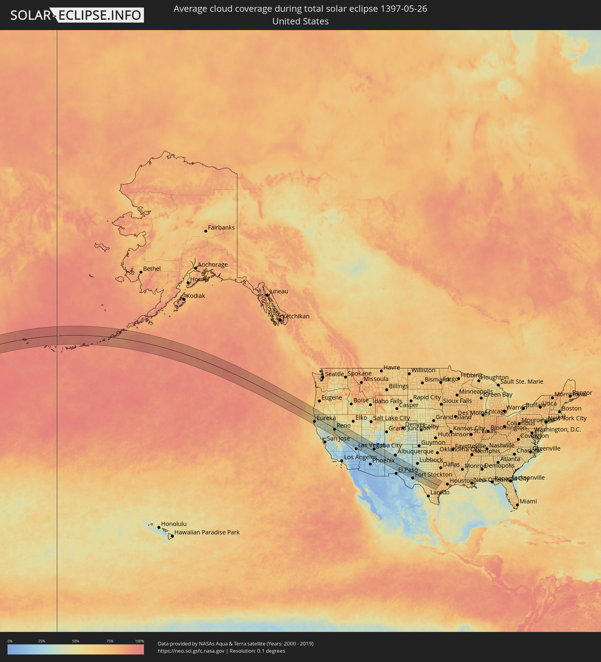 United States
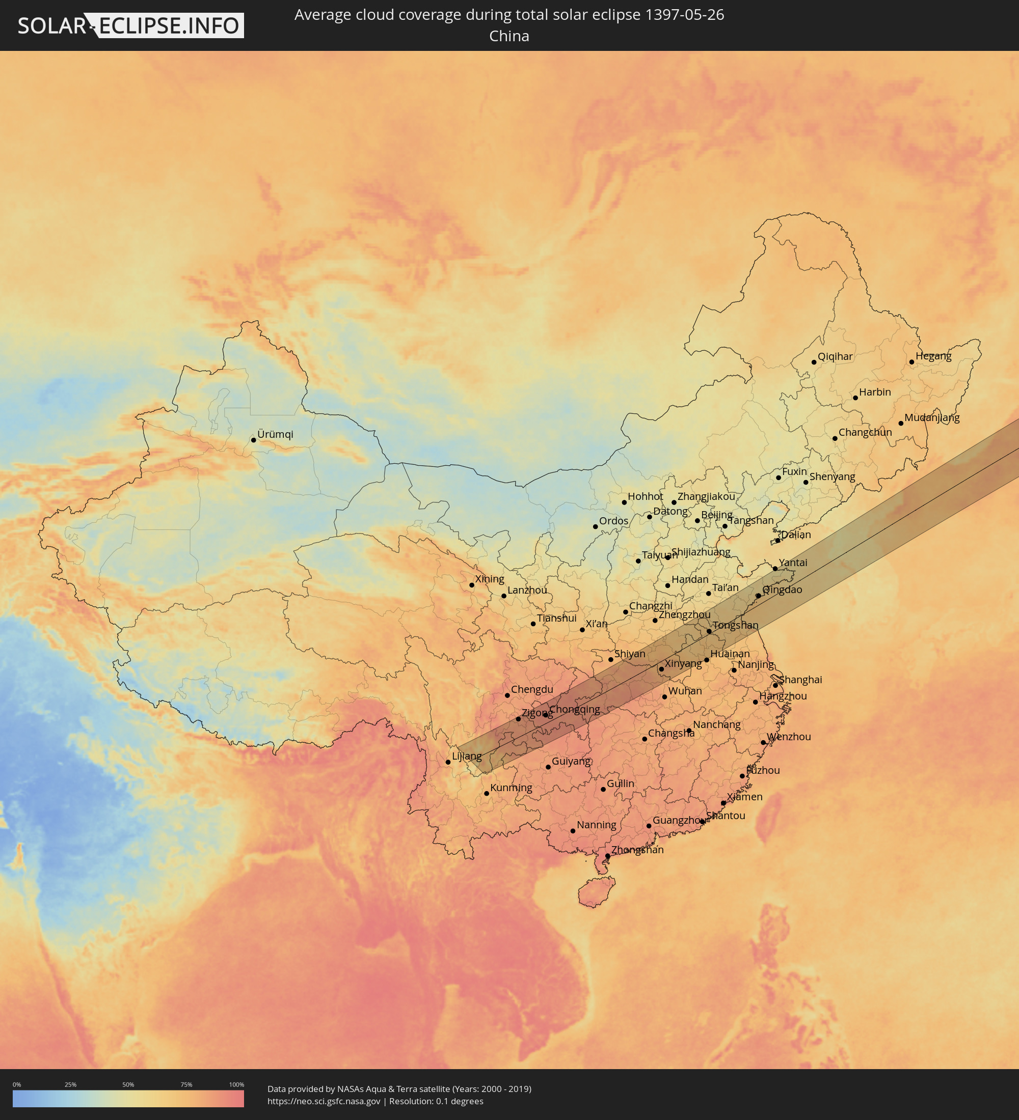 China
China
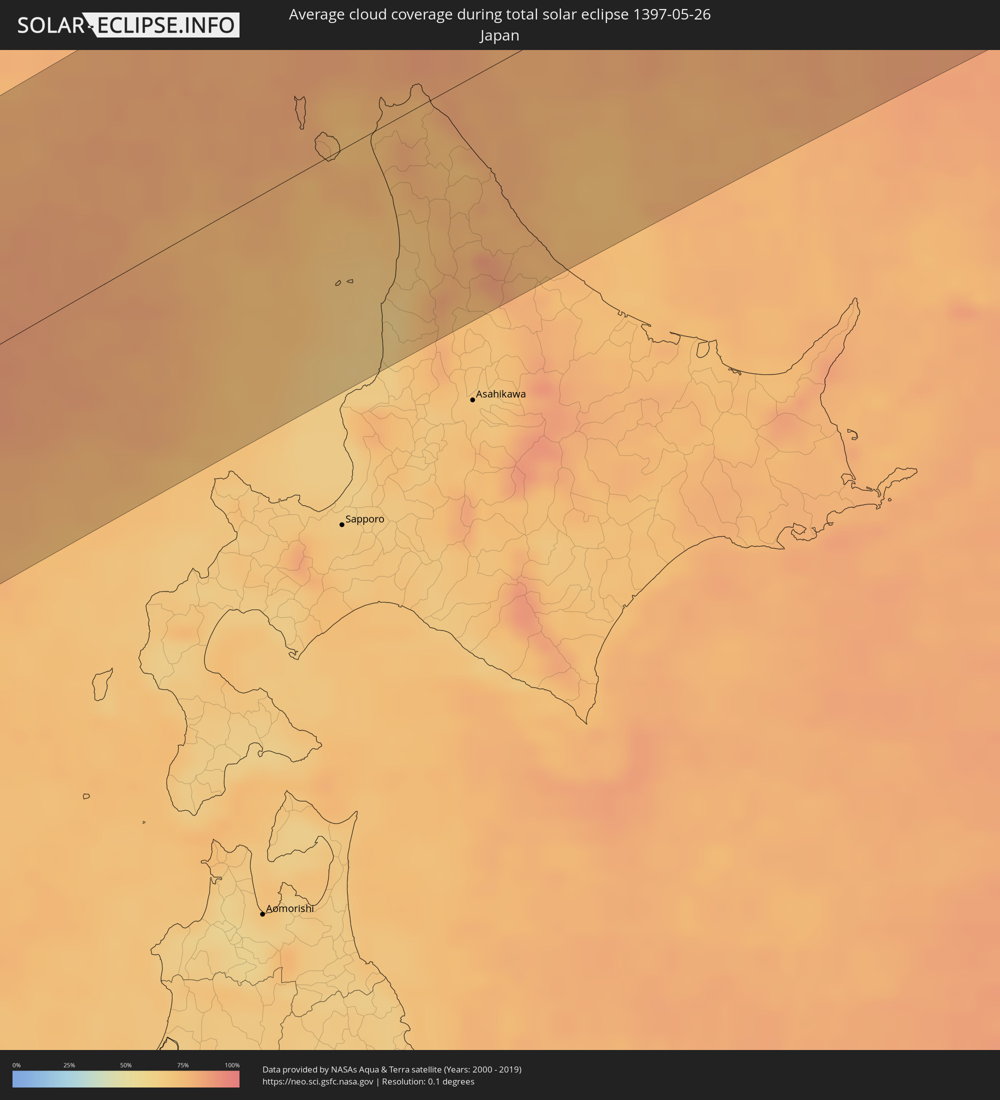 Japan
Japan
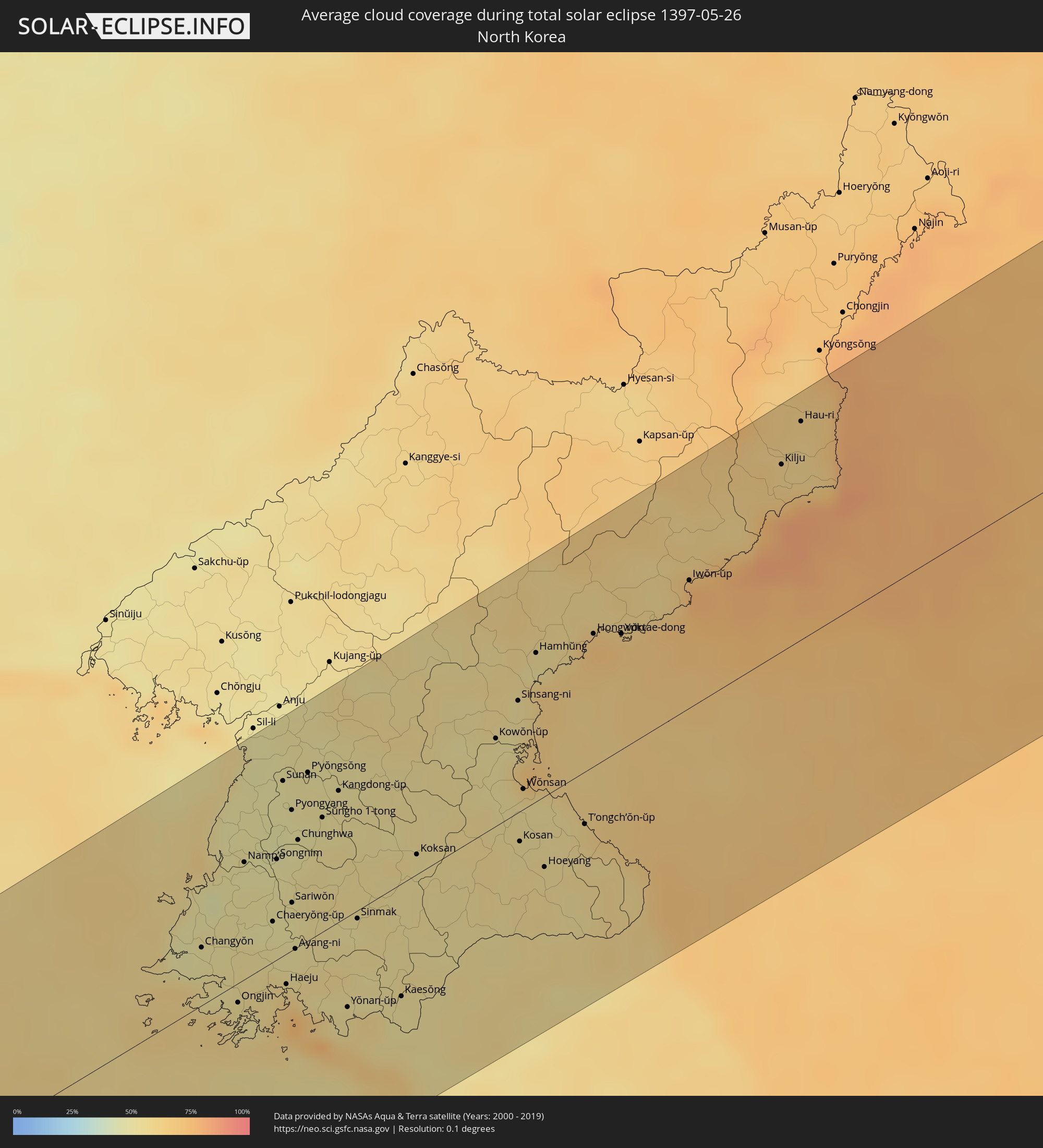 North Korea
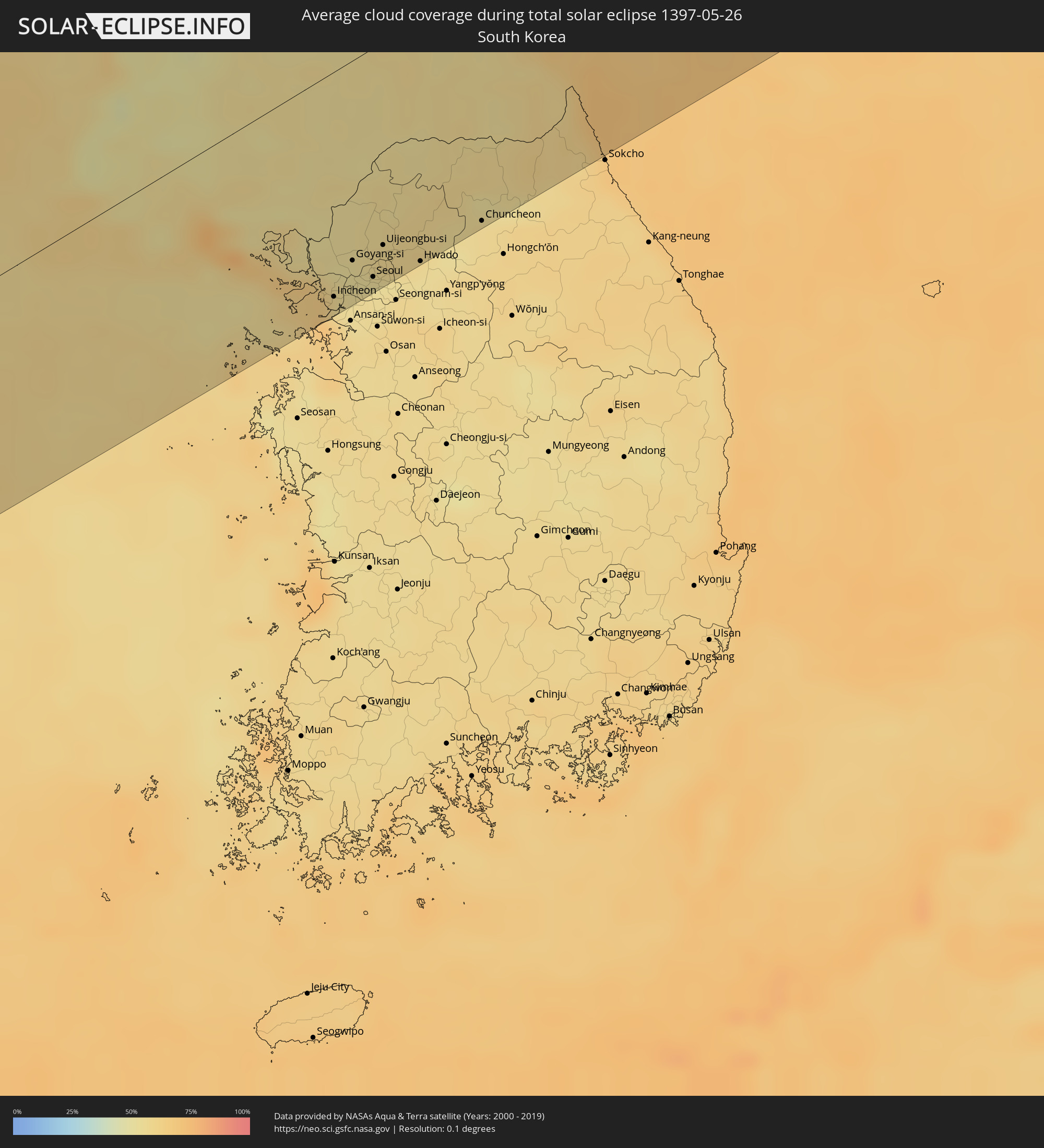 South Korea
Cities inside the path of the eclipse
The following table shows all locations with a population of more than 5,000 inside the eclipse path. Cities which have more than 100,000 inhabitants are marked bold. A click at the locations opens a detailed map.
| City | Type | Eclipse duration | Local time of max. eclipse | Distance to central line | Ø Cloud coverage |
|
Eureka, California
|
total | - | 17:08:17 UTC-08:00 | 77 km | 65% |
|
Grants Pass, Oregon
|
total | - | 17:06:16 UTC-08:00 | 116 km | 51% |
|
Medford, Oregon
|
total | - | 17:06:34 UTC-08:00 | 124 km | 53% |
|
Ashland, Oregon
|
total | - | 17:06:49 UTC-08:00 | 118 km | 55% |
|
Redding, California
|
total | - | 17:09:11 UTC-08:00 | 33 km | 38% |
|
Chico, California
|
total | - | 17:10:32 UTC-08:00 | 84 km | 33% |
|
Paradise, California
|
total | - | 17:10:33 UTC-08:00 | 73 km | 39% |
|
Susanville, California
|
total | - | 17:09:54 UTC-08:00 | 37 km | 52% |
|
South Lake Tahoe, California
|
total | - | 17:12:05 UTC-08:00 | 80 km | 54% |
|
Reno, Nevada
|
total | - | 17:11:19 UTC-08:00 | 15 km | 45% |
|
Carson City, Nevada
|
total | - | 17:11:50 UTC-08:00 | 48 km | 42% |
|
Fernley, Nevada
|
total | - | 17:11:20 UTC-08:00 | 17 km | 41% |
|
Saint George, Utah
|
total | - | 18:15:18 UTC-07:00 | 32 km | 18% |
|
Cedar City, Utah
|
total | - | 18:14:36 UTC-07:00 | 102 km | 34% |
|
Flagstaff, Arizona
|
total | - | 18:17:39 UTC-07:00 | 80 km | 30% |
|
Gallup, New Mexico
|
total | - | 18:17:05 UTC-07:00 | 88 km | 32% |
|
Alamogordo, New Mexico
|
total | - | 18:19:40 UTC-07:00 | 48 km | 18% |
|
Roswell, New Mexico
|
total | - | 18:18:50 UTC-07:00 | 64 km | 30% |
|
Carlsbad, New Mexico
|
total | - | 18:19:49 UTC-07:00 | 24 km | 28% |
|
Hobbs, New Mexico
|
total | - | 18:19:16 UTC-07:00 | 58 km | 31% |
|
Odessa, Texas
|
total | - | 19:19:57 UTC-06:00 | 6 km | 26% |
|
Midland, Texas
|
total | - | 19:19:43 UTC-06:00 | 43 km | 31% |
|
Big Spring, Texas
|
total | - | 19:19:17 UTC-06:00 | 86 km | 35% |
|
San Angelo, Texas
|
total | - | 19:19:46 UTC-06:00 | 57 km | 48% |
|
Kerrville, Texas
|
total | - | 19:20:43 UTC-06:00 | 31 km | 63% |
|
San Antonio, Texas
|
total | - | 19:21:04 UTC-06:00 | 69 km | 63% |
|
Schertz, Texas
|
total | - | 19:20:52 UTC-06:00 | 44 km | 66% |
|
Canyon Lake, Texas
|
total | - | 19:20:33 UTC-06:00 | 25 km | 65% |
|
New Braunfels, Texas
|
total | - | 19:20:40 UTC-06:00 | 22 km | 68% |
|
Seguin, Texas
|
total | - | 19:20:44 UTC-06:00 | 34 km | 67% |
|
San Marcos, Texas
|
total | - | 19:20:26 UTC-06:00 | 6 km | 69% |
|
Leander, Texas
|
total | - | 19:19:45 UTC-06:00 | 80 km | 66% |
|
Austin, Texas
|
total | - | 19:20:00 UTC-06:00 | 51 km | 68% |
|
Round Rock, Texas
|
total | - | 19:19:45 UTC-06:00 | 78 km | 71% |
|
Yibin, Sichuan
|
total | - | 06:23:09 UTC+08:00 | 51 km | 86% |
|
Zigong, Sichuan
|
total | - | 06:23:41 UTC+08:00 | 101 km | 85% |
|
Neijiang, Sichuan
|
total | - | 06:23:51 UTC+08:00 | 110 km | 87% |
|
Chongqing, Chongqing
|
total | - | 06:23:24 UTC+08:00 | 49 km | 88% |
|
Fuling, Chongqing
|
total | - | 06:23:20 UTC+08:00 | 18 km | 86% |
|
Wanxian, Chongqing
|
total | - | 06:24:18 UTC+08:00 | 87 km | 88% |
|
Yichang, Hubei
|
total | - | 06:23:39 UTC+08:00 | 58 km | 86% |
|
Zhicheng, Hubei
|
total | - | 06:23:09 UTC+08:00 | 109 km | 84% |
|
Laohekou, Hubei
|
total | - | 06:25:30 UTC+08:00 | 88 km | 83% |
|
Xiangyang, Hubei
|
total | - | 06:25:03 UTC+08:00 | 38 km | 82% |
|
Jingmen, Hubei
|
total | - | 06:23:53 UTC+08:00 | 71 km | 88% |
|
Nanyang, Henan
|
total | - | 06:26:07 UTC+08:00 | 107 km | 76% |
|
Zaoyang, Hubei
|
total | - | 06:25:04 UTC+08:00 | 13 km | 84% |
|
Suizhou, Hubei
|
total | - | 06:24:32 UTC+08:00 | 56 km | 83% |
|
Zhumadian, Henan
|
total | - | 06:25:58 UTC+08:00 | 44 km | 77% |
|
Luohe, Henan
|
total | - | 06:26:41 UTC+08:00 | 93 km | 75% |
|
Xinyang, Henan
|
total | - | 06:24:57 UTC+08:00 | 52 km | 77% |
|
Zhoukou, Henan
|
total | - | 06:26:44 UTC+08:00 | 72 km | 71% |
|
Shangqiu, Henan
|
total | - | 06:27:43 UTC+08:00 | 106 km | 66% |
|
Bozhou, Anhui
|
total | - | 06:27:00 UTC+08:00 | 43 km | 64% |
|
Fuyang, Anhui
|
total | - | 06:25:48 UTC+08:00 | 53 km | 72% |
|
Huaibei, Anhui
|
total | - | 06:27:07 UTC+08:00 | 20 km | 68% |
|
Suzhou, Anhui
|
total | - | 06:26:42 UTC+08:00 | 43 km | 71% |
|
Tongshan, Jiangsu
|
total | - | 06:27:23 UTC+08:00 | 23 km | 69% |
|
Bengbu, Anhui
|
total | - | 06:25:51 UTC+08:00 | 123 km | 71% |
|
Zaozhuang, Shandong
|
total | - | 06:28:16 UTC+08:00 | 58 km | 63% |
|
Linyi, Shandong
|
total | - | 06:28:33 UTC+08:00 | 39 km | 65% |
|
Xinpu, Jiangsu
|
total | - | 06:28:01 UTC+08:00 | 45 km | 67% |
|
Zhu Cheng City, Shandong
|
total | - | 06:29:52 UTC+08:00 | 80 km | 62% |
|
Rizhao, Shandong
|
total | - | 06:29:07 UTC+08:00 | 23 km | 68% |
|
Jiaozhou, Shandong
|
total | - | 06:30:18 UTC+08:00 | 79 km | 59% |
|
Qingdao, Shandong
|
total | - | 06:30:04 UTC+08:00 | 42 km | 66% |
|
Laiyang, Shandong
|
total | - | 06:31:20 UTC+08:00 | 113 km | 55% |
|
Yantai, Shandong
|
total | - | 06:32:07 UTC+08:00 | 127 km | 53% |
|
Changyŏn, Hwanghae-namdo
|
total | - | 06:57:01 UTC+08:23 | 39 km | 50% |
|
Ongjin, Hwanghae-namdo
|
total | - | 06:56:39 UTC+08:23 | 23 km | 54% |
|
Namp’o, P'yŏngan-namdo
|
total | - | 06:57:48 UTC+08:23 | 67 km | 49% |
|
Anak, Hwanghae-bukto
|
total | - | 06:57:30 UTC+08:23 | 44 km | 50% |
|
Chaeryŏng-ŭp, Hwanghae-namdo
|
total | - | 06:57:22 UTC+08:23 | 34 km | 49% |
|
Songnim, Hwanghae-bukto
|
total | - | 06:57:53 UTC+08:23 | 54 km | 49% |
|
Sunan, Pyongyang
|
total | - | 06:58:32 UTC+08:23 | 98 km | 49% |
|
Haeju, Hwanghae-namdo
|
total | - | 06:56:54 UTC+08:23 | 20 km | 63% |
|
Pyongyang, Pyongyang
|
total | - | 06:58:19 UTC+08:23 | 79 km | 50% |
|
Sariwŏn, Hwanghae-bukto
|
total | - | 06:57:34 UTC+08:23 | 27 km | 50% |
|
Hwangju-ŭp, Hwanghae-bukto
|
total | - | 06:57:48 UTC+08:23 | 41 km | 53% |
|
Ayang-ni, Hwanghae-namdo
|
total | - | 06:57:12 UTC+08:23 | 23 km | 53% |
|
Hŭkkyo-ri, Hwanghae-bukto
|
total | - | 06:58:00 UTC+08:23 | 53 km | 50% |
|
Chunghwa, Pyongyang
|
total | - | 06:58:05 UTC+08:23 | 60 km | 49% |
|
P’yŏngsŏng, P'yŏngan-namdo
|
total | - | 06:58:39 UTC+08:23 | 91 km | 52% |
|
Sŭngho 1-tong, Pyongyang
|
total | - | 06:58:20 UTC+08:23 | 64 km | 51% |
|
Kangdong-ŭp, Pyongyang
|
total | - | 06:58:35 UTC+08:23 | 71 km | 52% |
|
Yŏnan-ŭp, Hwanghae-namdo
|
total | - | 06:56:51 UTC+08:23 | 51 km | 56% |
|
Sinmak, Hwanghae-bukto
|
total | - | 06:57:35 UTC+08:23 | 22 km | 51% |
|
Ganghwa-gun, Incheon
|
total | - | 07:01:35 UTC+08:27 | 80 km | 57% |
|
Kaesŏng, Hwanghae-namdo
|
total | - | 06:57:03 UTC+08:23 | 64 km | 53% |
|
Incheon, Incheon
|
total | - | 07:01:15 UTC+08:27 | 117 km | 56% |
|
Bucheon-si, Gyeonggi-do
|
total | - | 07:01:20 UTC+08:27 | 117 km | 54% |
|
Munsan, Gyeonggi-do
|
total | - | 07:01:50 UTC+08:27 | 85 km | 53% |
|
Goyang-si, Gyeonggi-do
|
total | - | 07:01:34 UTC+08:27 | 107 km | 53% |
|
Kwangmyŏng, Gyeonggi-do
|
total | - | 07:01:19 UTC+08:27 | 124 km | 55% |
|
Seoul, Seoul
|
total | - | 07:01:29 UTC+08:27 | 121 km | 53% |
|
Uijeongbu-si, Gyeonggi-do
|
total | - | 07:01:45 UTC+08:27 | 106 km | 57% |
|
Yangju, Gyeonggi-do
|
total | - | 07:01:53 UTC+08:27 | 98 km | 57% |
|
Guri-si, Gyeonggi-do
|
total | - | 07:01:35 UTC+08:27 | 124 km | 53% |
|
Namyangju, Gyeonggi-do
|
total | - | 07:01:40 UTC+08:27 | 123 km | 54% |
|
Kowŏn-ŭp, Hamgyŏng-namdo
|
total | - | 06:59:23 UTC+08:23 | 47 km | 52% |
|
Hwado, Gyeonggi-do
|
total | - | 07:01:43 UTC+08:27 | 126 km | 56% |
|
Sinsang-ni, Hamgyŏng-namdo
|
total | - | 06:59:45 UTC+08:23 | 60 km | 54% |
|
Kosan, Kangwŏn-do
|
total | - | 06:58:36 UTC+08:23 | 24 km | 54% |
|
Wŏnsan, Kangwŏn-do
|
total | - | 06:59:03 UTC+08:23 | 11 km | 55% |
|
Yŏnggwang-ŭp, Hamgyŏng-namdo
|
total | - | 07:00:18 UTC+08:23 | 92 km | 56% |
|
Gapyeong, Gyeonggi-do
|
total | - | 07:02:02 UTC+08:27 | 120 km | 52% |
|
Anbyŏn-ŭp, Kangwŏn-do
|
total | - | 06:58:55 UTC+08:23 | 3 km | 54% |
|
Hamhŭng, Hamgyŏng-namdo
|
total | - | 07:00:11 UTC+08:23 | 79 km | 53% |
|
Hoeyang, Kangwŏn-do
|
total | - | 06:58:28 UTC+08:23 | 40 km | 55% |
|
Hwacheon, Gangwon-do
|
total | - | 07:02:30 UTC+08:27 | 101 km | 52% |
|
Chuncheon, Gangwon-do
|
total | - | 07:02:11 UTC+08:27 | 124 km | 56% |
|
Samho-rodongjagu, Hamgyŏng-namdo
|
total | - | 07:00:21 UTC+08:23 | 71 km | 65% |
|
T’ongch’ŏn-ŭp, Kangwŏn-do
|
total | - | 06:58:55 UTC+08:23 | 36 km | 60% |
|
Hongwŏn, Hamgyŏng-namdo
|
total | - | 07:00:30 UTC+08:23 | 72 km | 69% |
|
Yanggu, Gangwon-do
|
total | - | 07:02:36 UTC+08:27 | 115 km | 55% |
|
Yuktae-dong, Hamgyŏng-namdo
|
total | - | 07:00:34 UTC+08:23 | 62 km | 66% |
|
Kosong, Gangwon-do
|
total | - | 07:03:10 UTC+08:27 | 109 km | 66% |
|
Iwŏn-ŭp, Hamgyŏng-namdo
|
total | - | 07:01:12 UTC+08:23 | 68 km | 76% |
|
Kilju, Hamgyŏng-bukto
|
total | - | 07:02:26 UTC+08:23 | 99 km | 63% |
|
Nakhodka, Primorskiy
|
total | - | 07:31:26 UTC+08:47 | 119 km | 72% |
|
Vladimiro-Aleksandrovskoye, Primorskiy
|
total | - | 07:31:39 UTC+08:47 | 118 km | 59% |
|
Vrangel’, Primorskiy
|
total | - | 07:31:25 UTC+08:47 | 102 km | 75% |
|
Preobrazheniye, Primorskiy
|
total | - | 07:32:08 UTC+08:47 | 84 km | 73% |
|
Rumoi, Hokkaido
|
total | - | 07:51:36 UTC+09:00 | 131 km | 65% |
|
Wakkanai, Hokkaido
|
total | - | 07:53:52 UTC+09:00 | 12 km | 74% |
|
Makubetsu, Hokkaido
|
total | - | 07:53:56 UTC+09:00 | 2 km | 76% |
|
Gornozavodsk, Sakhalin
|
total | - | 09:10:37 UTC+10:14 | 117 km | 78% |
|
Nevel’sk, Sakhalin
|
total | - | 09:10:48 UTC+10:14 | 128 km | 74% |
|
Nayoro, Hokkaido
|
total | - | 07:52:55 UTC+09:00 | 122 km | 74% |
|
Aniva, Sakhalin
|
total | - | 09:11:25 UTC+10:14 | 106 km | 79% |
|
Yuzhno-Sakhalinsk, Sakhalin
|
total | - | 09:11:57 UTC+10:14 | 122 km | 76% |
|
Korsakov, Sakhalin
|
total | - | 09:11:31 UTC+10:14 | 91 km | 78% |