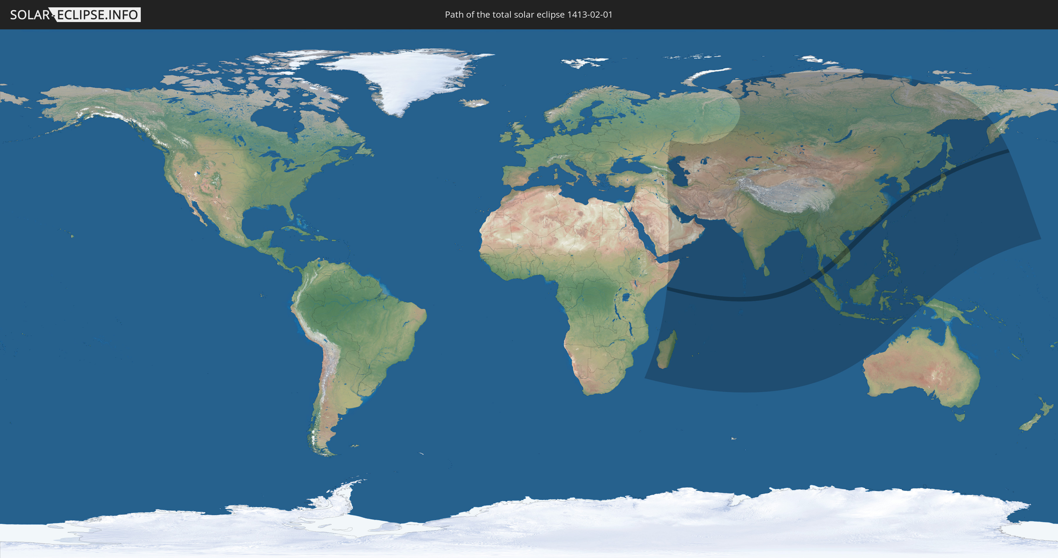
Total solar eclipse of 02/01/1413
| Day of week: | Monday |
| Maximum duration of eclipse: | 04m25s |
| Maximum width of eclipse path: | 187 km |
| Saros cycle: | 121 |
| Coverage: | 100% |
| Magnitude: | 1.0509 |
| Gamma: | 0.4429 |
Wo kann man die Sonnenfinsternis vom 02/01/1413 sehen?
Die Sonnenfinsternis am 02/01/1413 kann man in 60 Ländern als partielle Sonnenfinsternis beobachten.
Der Finsternispfad verläuft durch 10 Länder. Nur in diesen Ländern ist sie als total Sonnenfinsternis zu sehen.
In den folgenden Ländern ist die Sonnenfinsternis total zu sehen
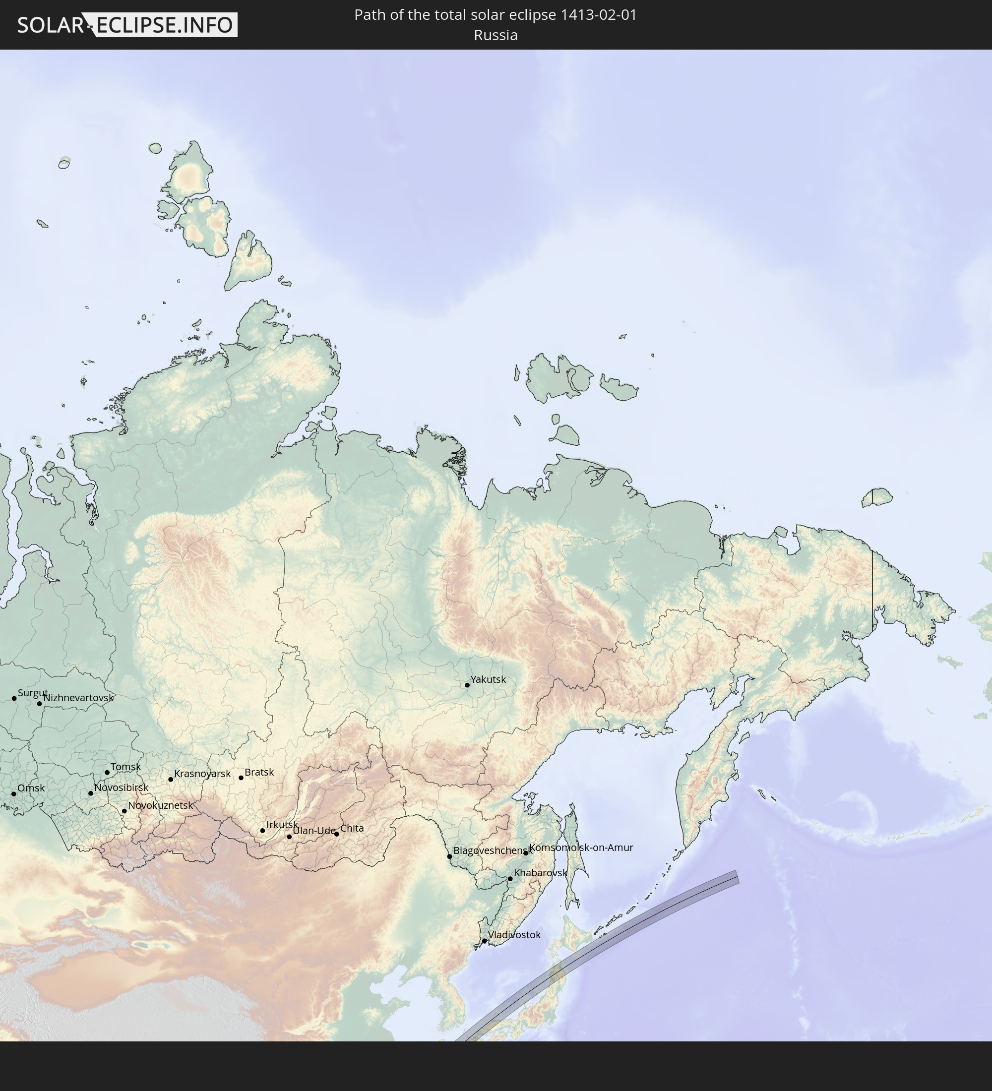 Russia
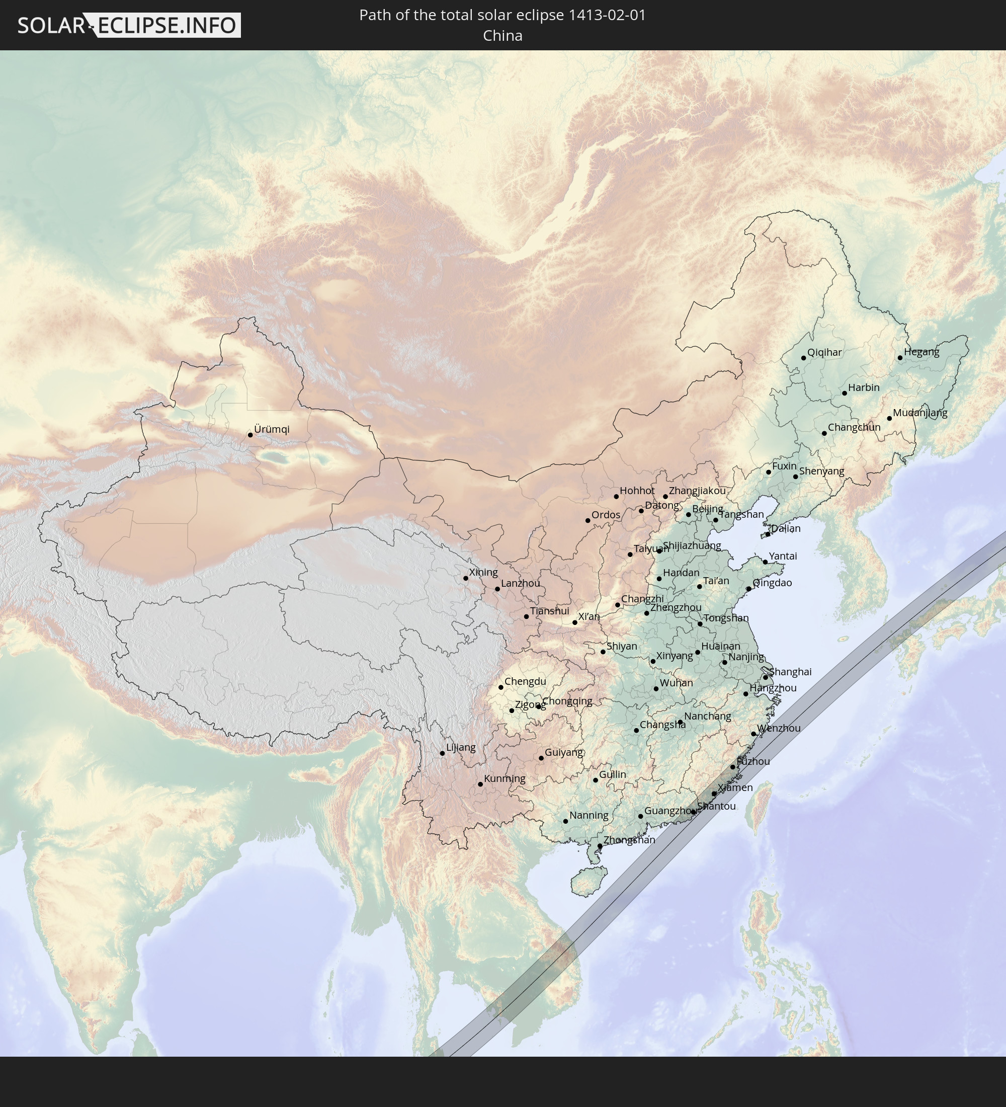 China
China
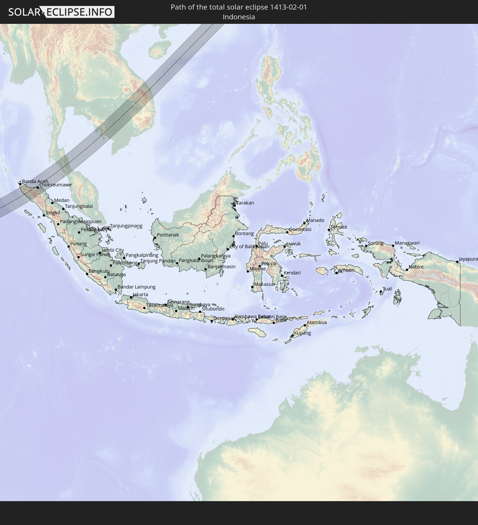 Indonesia
 Thailand
 Malaysia
 Laos
Laos
 Vietnam
 Cambodia
 Taiwan
 Japan
Japan
In den folgenden Ländern ist die Sonnenfinsternis partiell zu sehen
 Russia
 United States Minor Outlying Islands
 Ethiopia
 Saudi Arabia
 Iraq
Iraq
 French Southern and Antarctic Lands
 Somalia
 Yemen
Yemen
 Madagascar
 Iran
Iran
 Azerbaijan
 Mayotte
 Seychelles
 Kazakhstan
 Kuwait
 Bahrain
 Qatar
Qatar
 United Arab Emirates
 Oman
Oman
 Turkmenistan
 Réunion
 Uzbekistan
 Mauritius
 Afghanistan
 Pakistan
 Tajikistan
 India
India
 Kyrgyzstan
 British Indian Ocean Territory
 Maldives
 China
China
 Sri Lanka
 Nepal
Nepal
 Mongolia
 Bangladesh
 Bhutan
 Myanmar
 Indonesia
 Cocos Islands
 Thailand
 Malaysia
 Laos
Laos
 Vietnam
 Cambodia
 Singapore
 Christmas Island
 Australia
 Macau
Macau
 Hong Kong
 Brunei
 Taiwan
 Philippines
 Japan
Japan
 East Timor
 North Korea
 South Korea
 Palau
Palau
 Federated States of Micronesia
 Guam
Guam
 Northern Mariana Islands
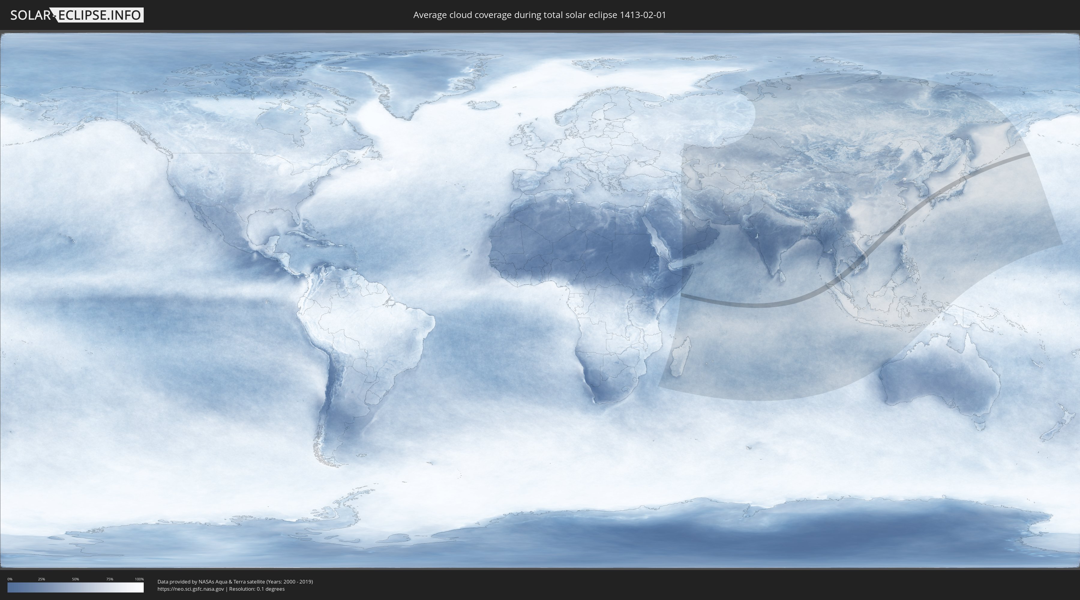
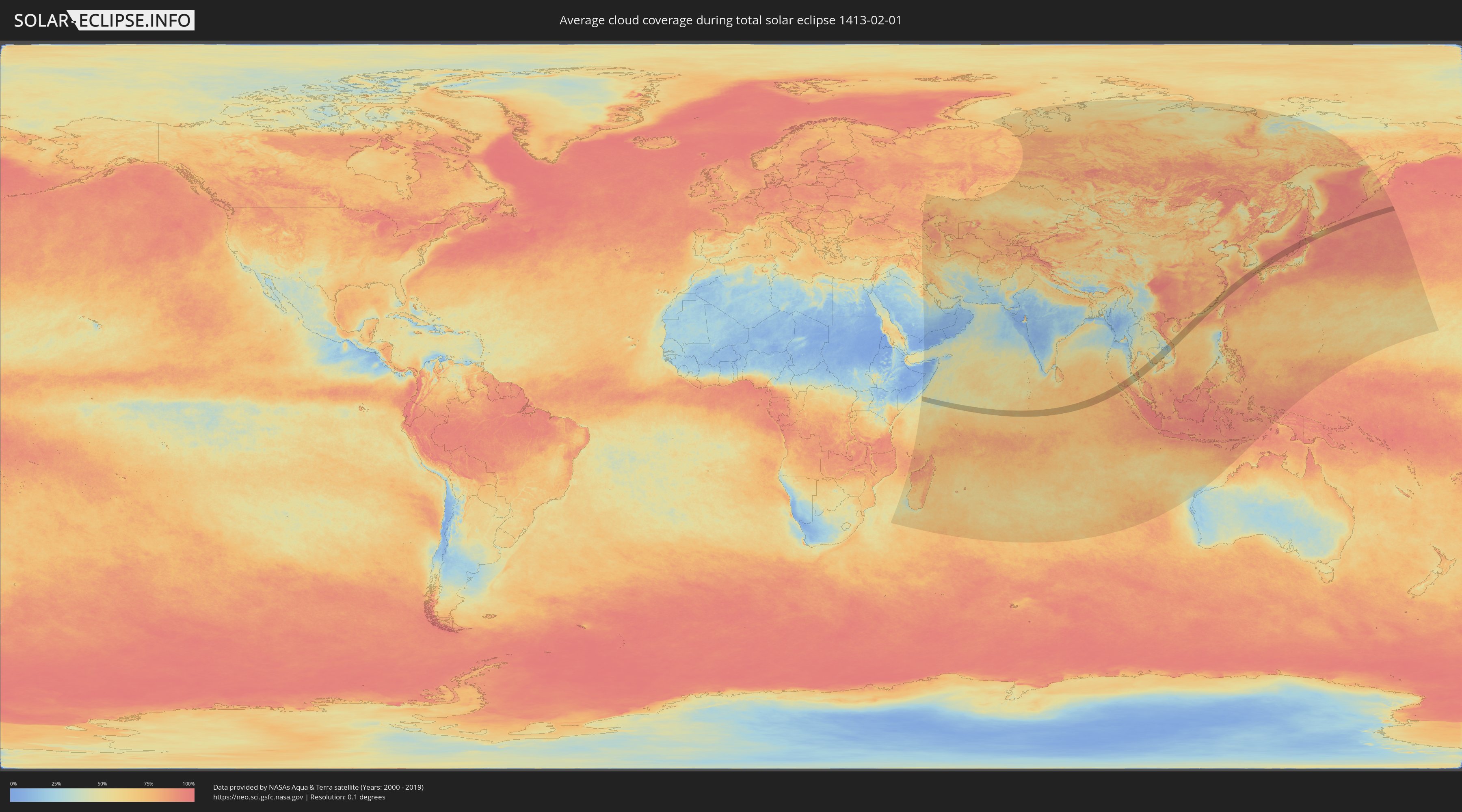
How will be the weather during the total solar eclipse on 02/01/1413?
Where is the best place to see the total solar eclipse of 02/01/1413?
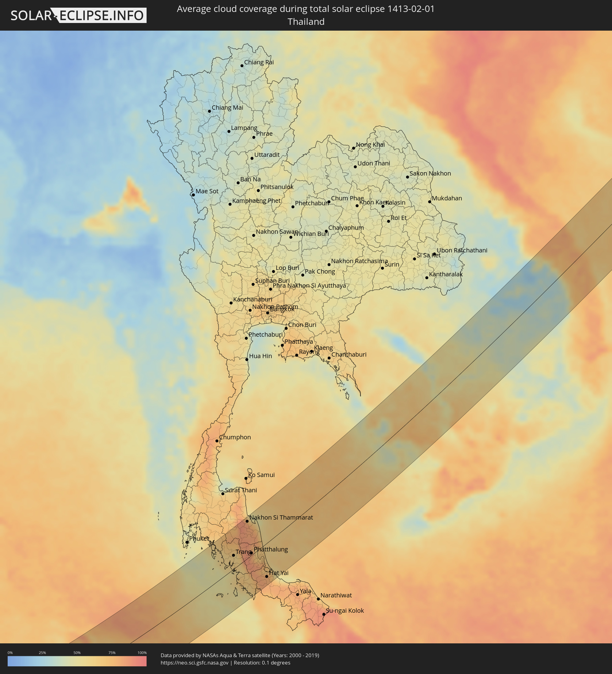
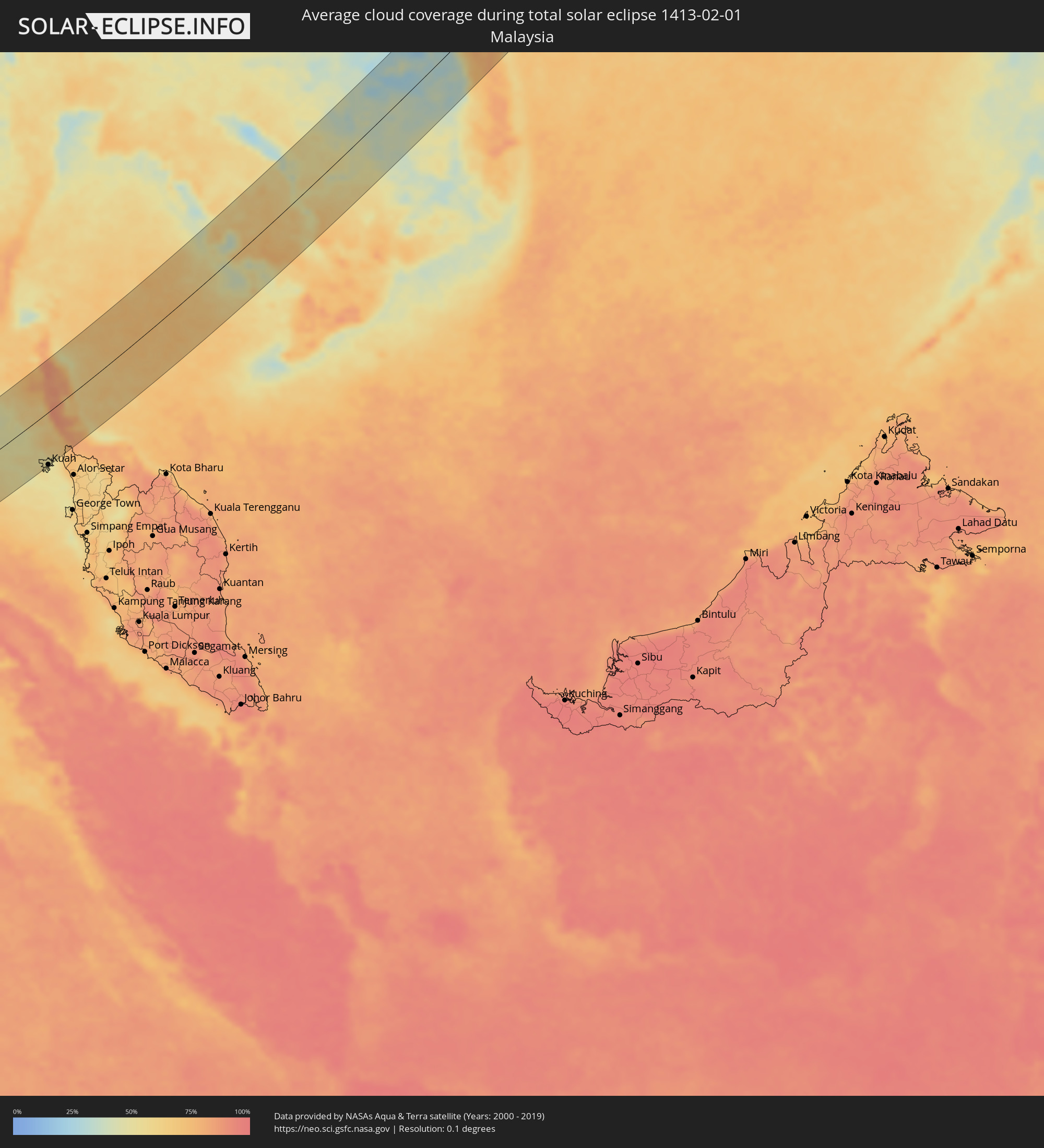
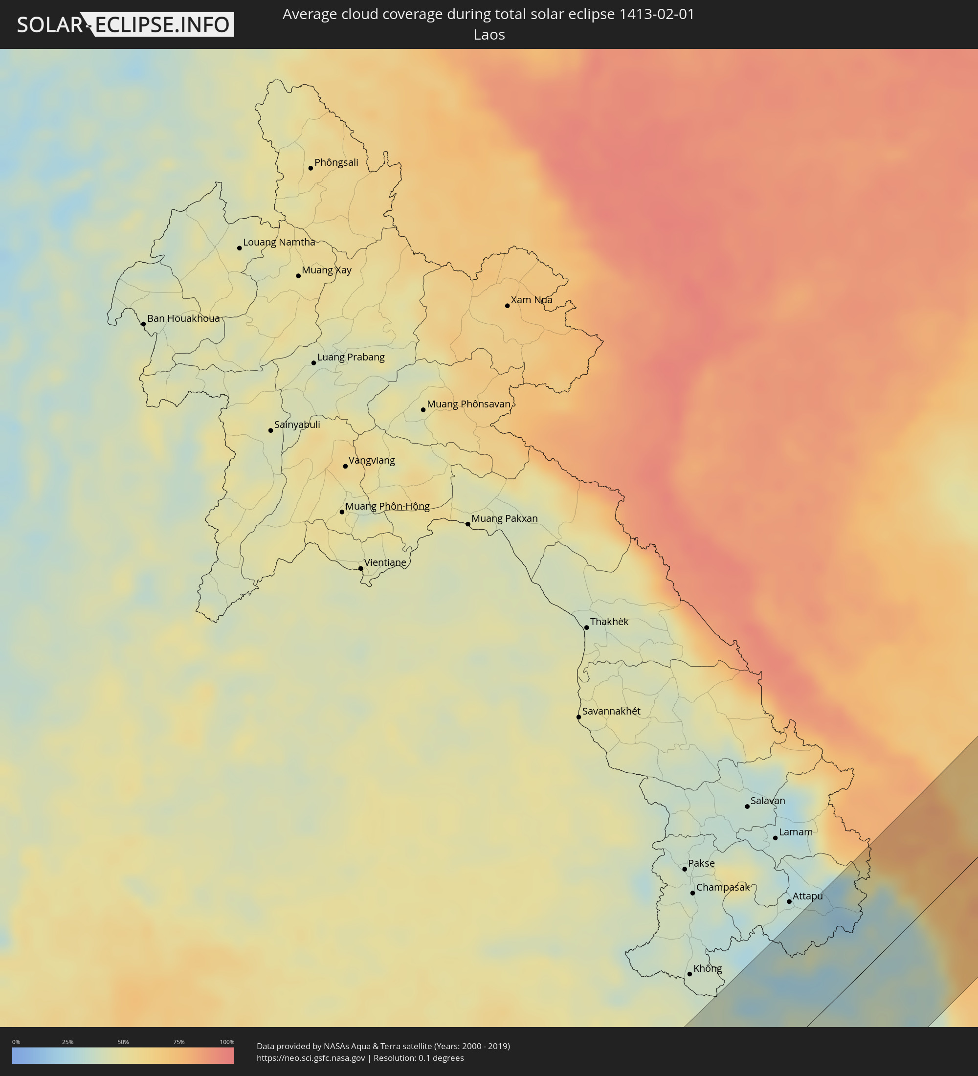
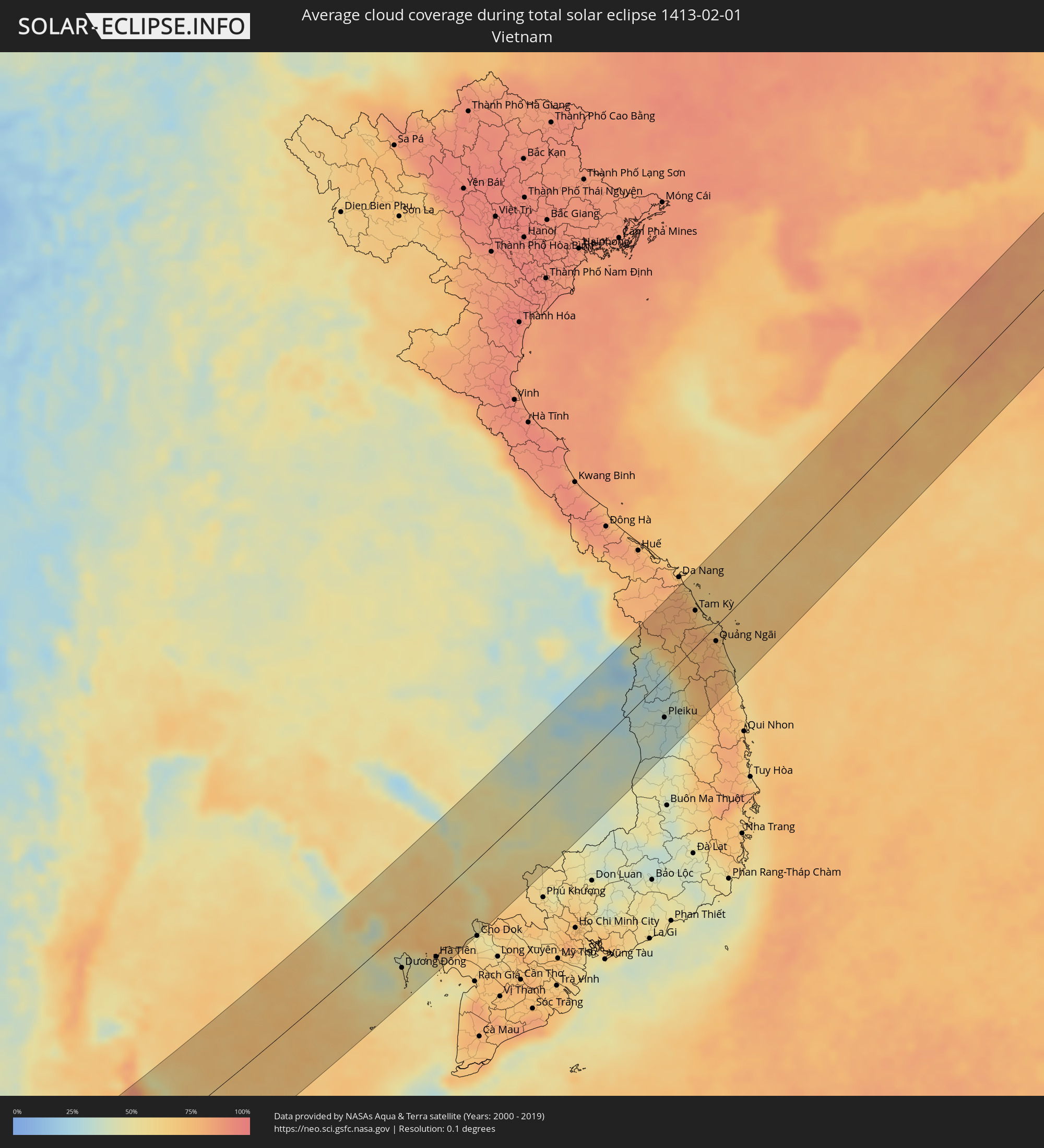
The following maps show the average cloud coverage for the day of the total solar eclipse.
With the help of these maps, it is possible to find the place along the eclipse path, which has the best
chance of a cloudless sky.
Nevertheless, you should consider local circumstances and inform about the weather of your chosen
observation site.
The data is provided by NASAs satellites
AQUA and TERRA.
The cloud maps are averaged over a period of 19 years (2000 - 2019).
Detailed country maps
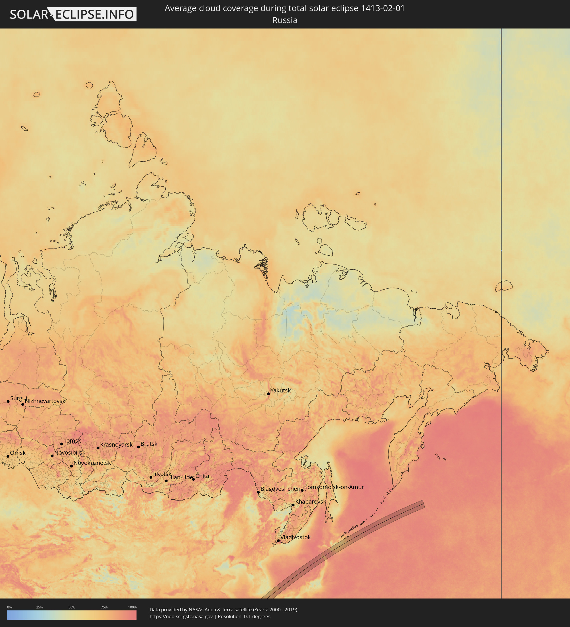 Russia
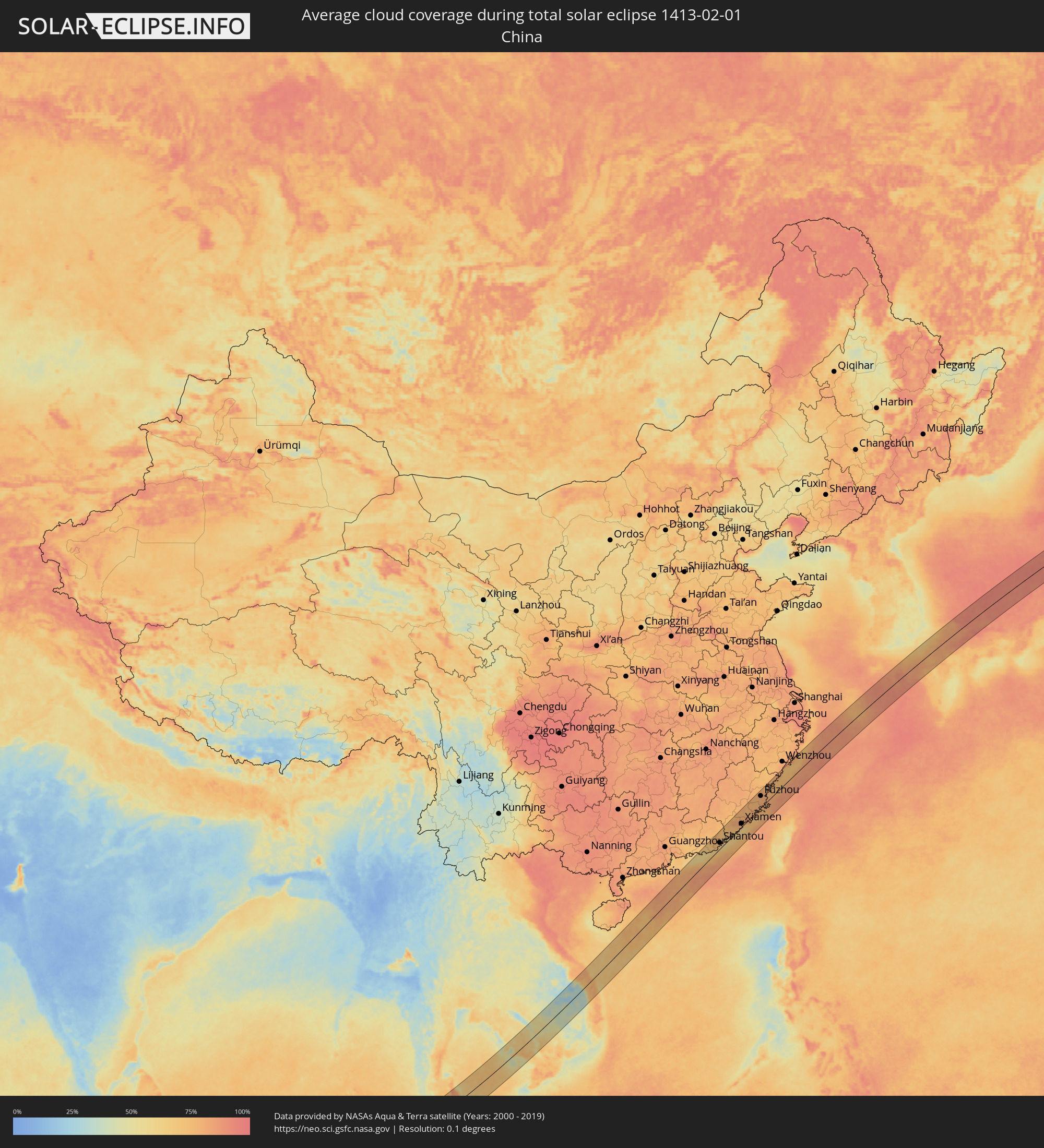 China
China
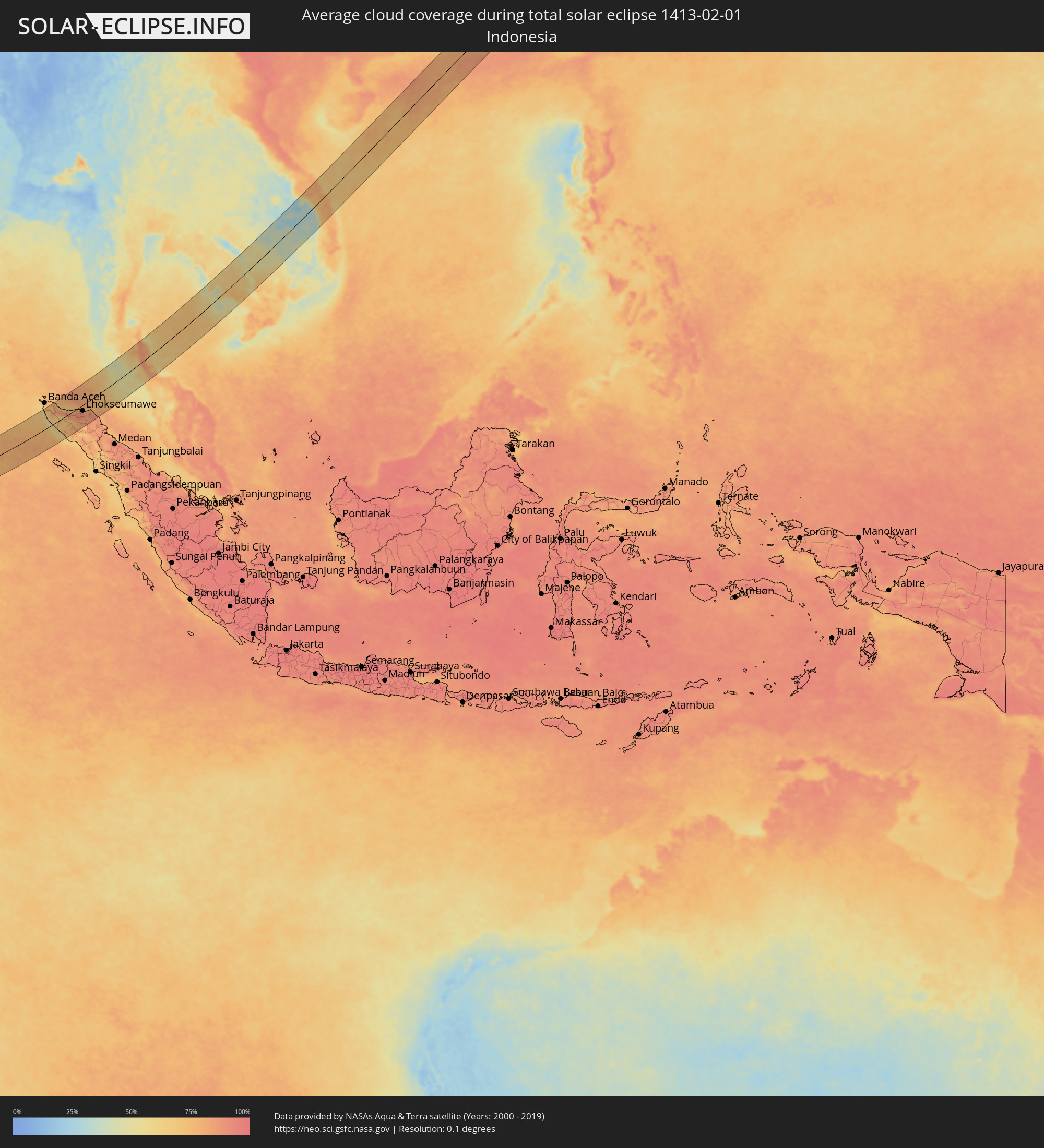 Indonesia
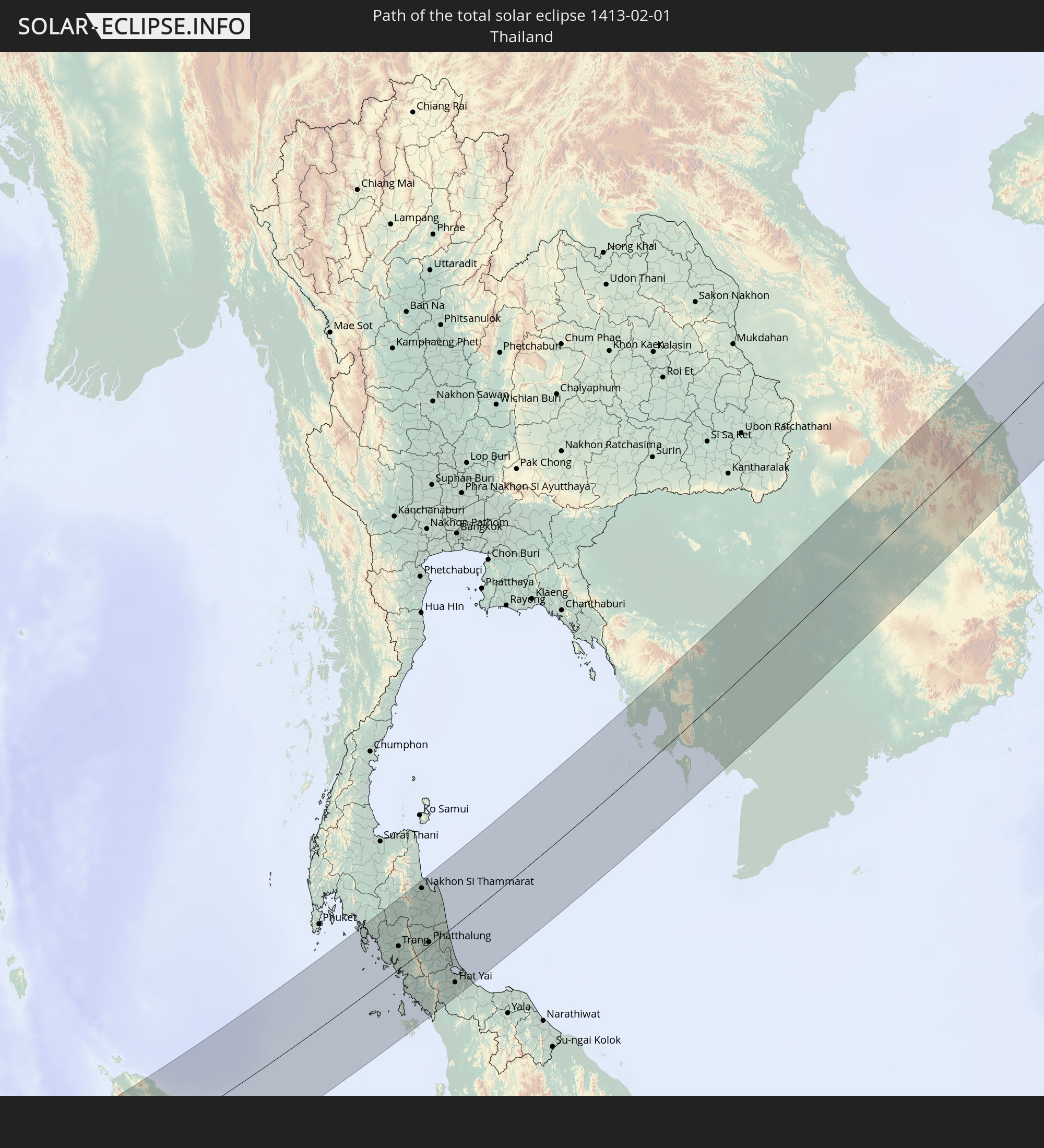
 Thailand
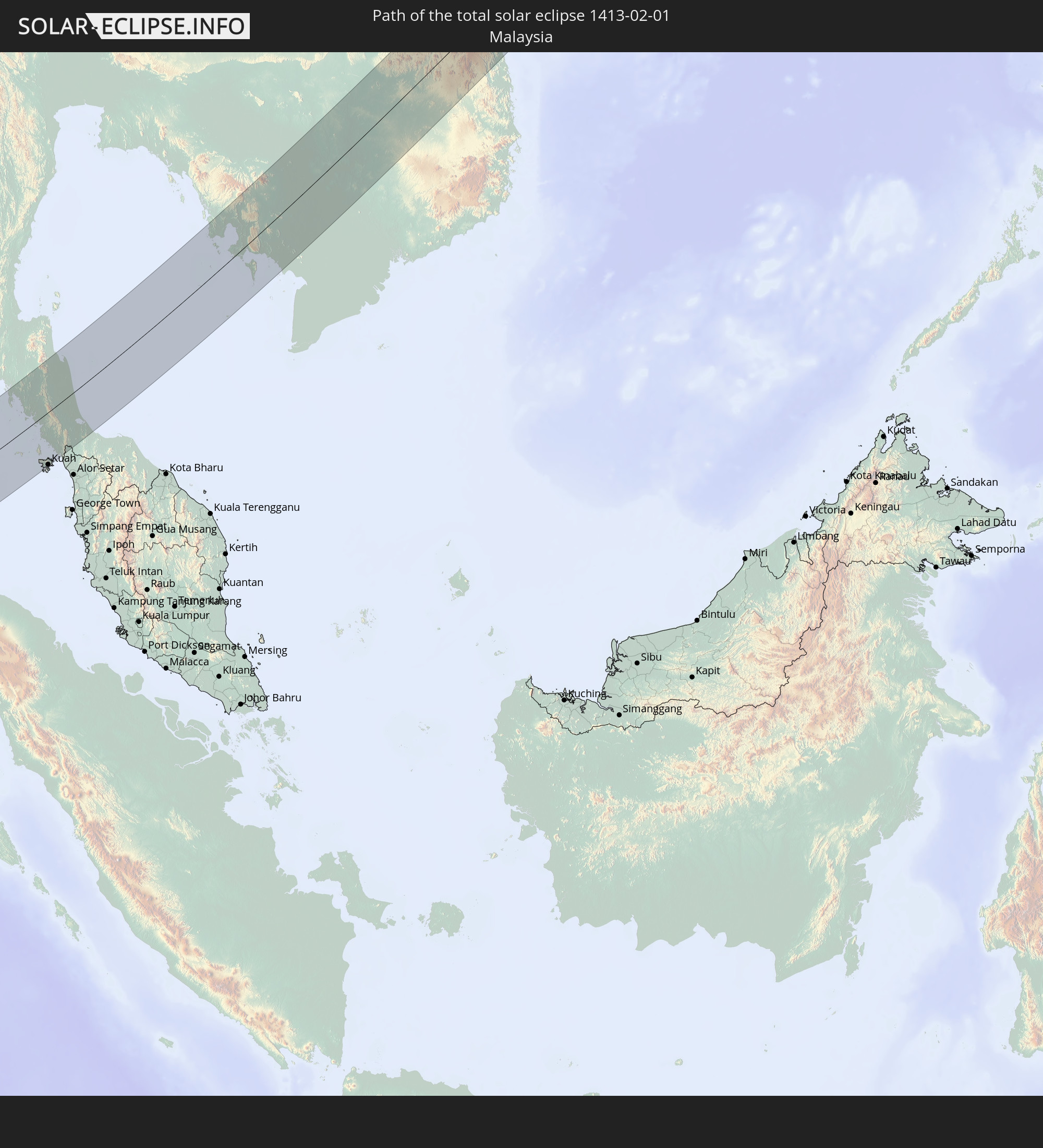
 Malaysia
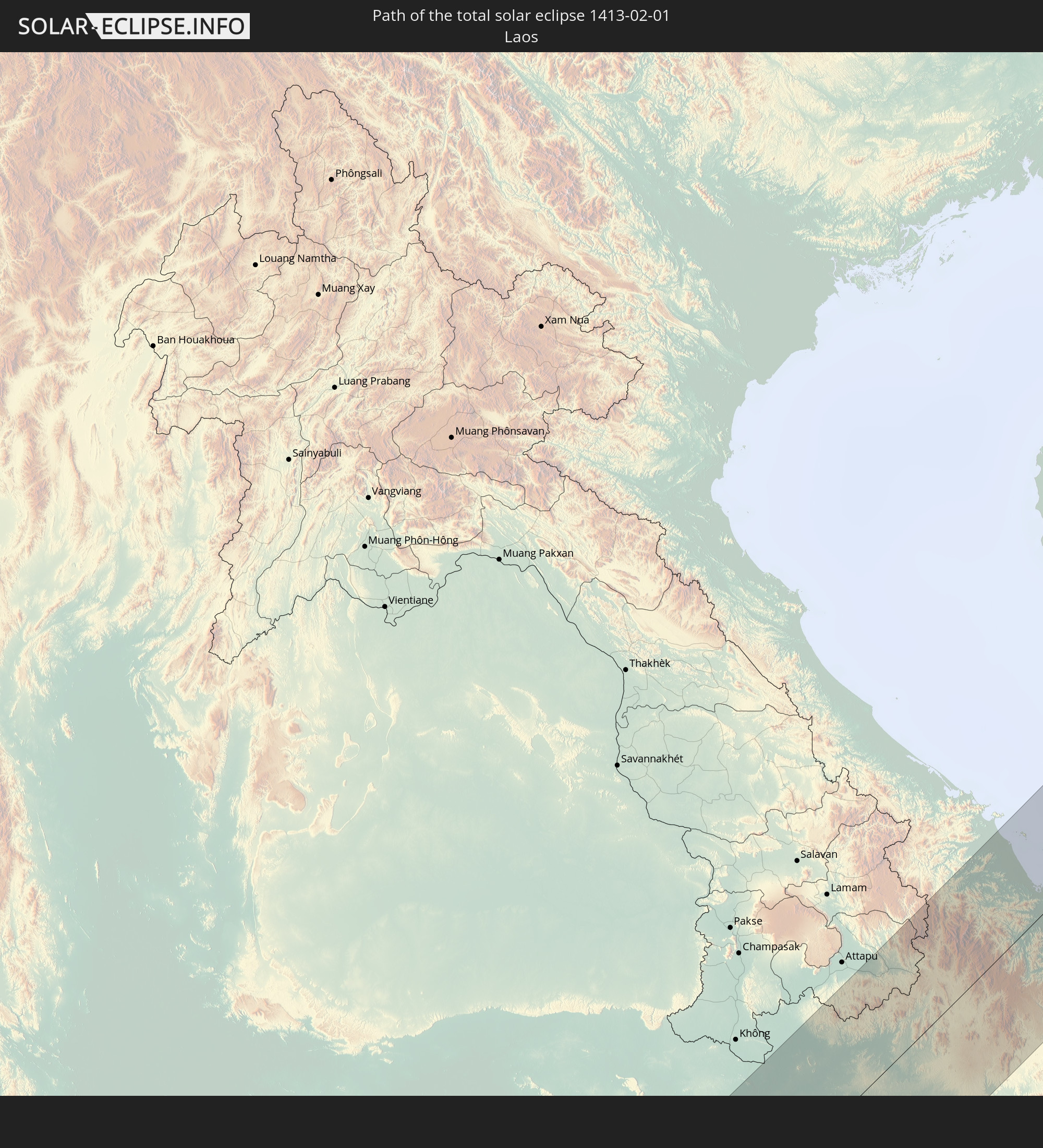
 Laos
Laos
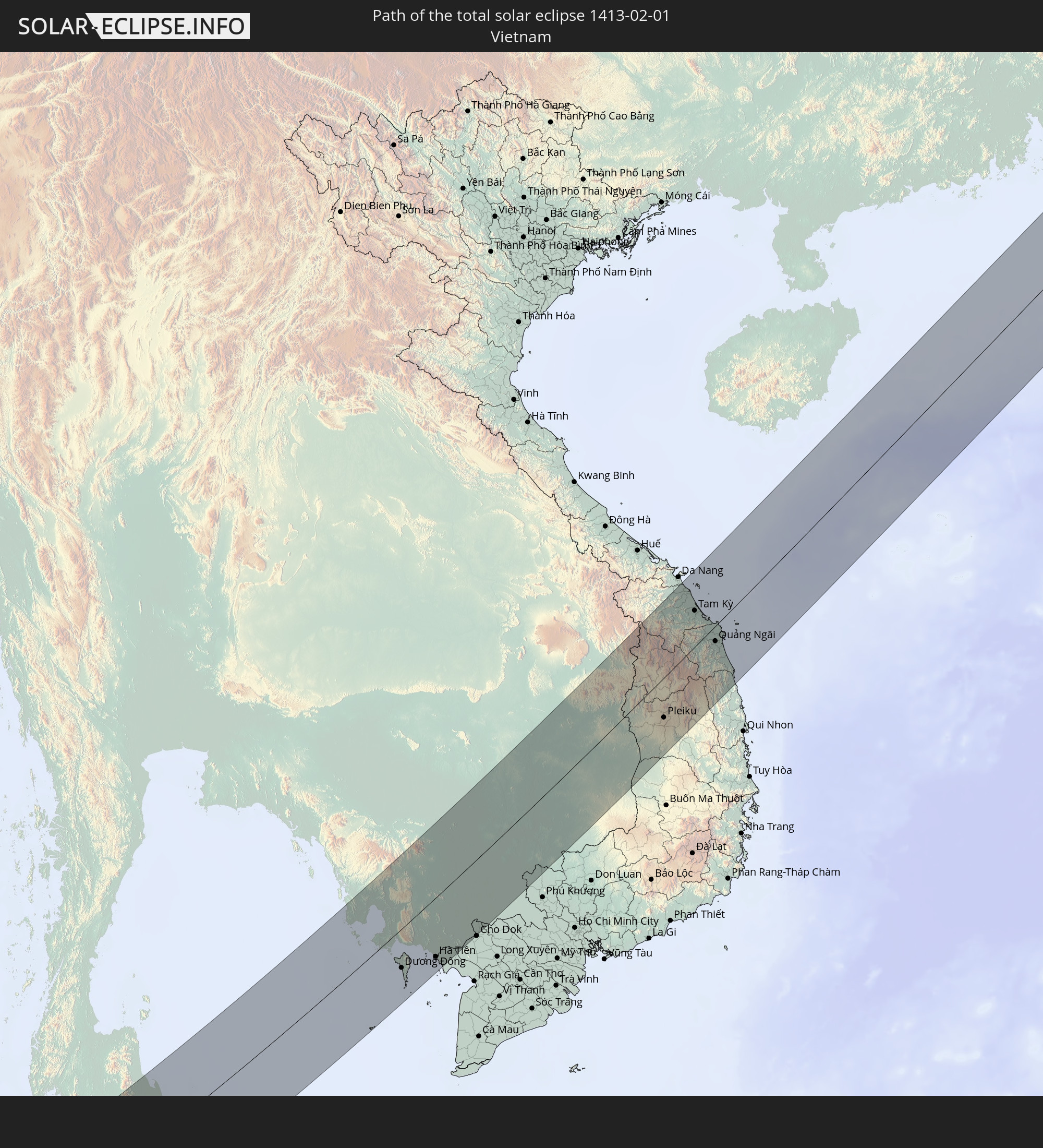
 Vietnam
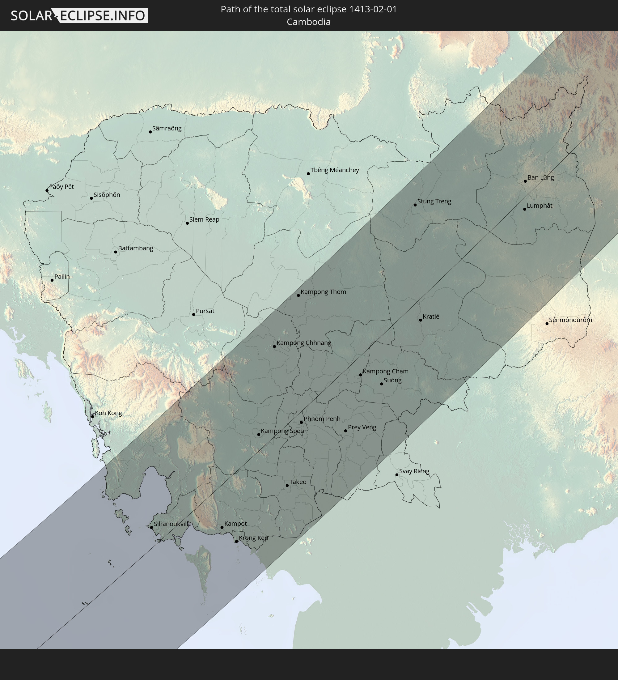
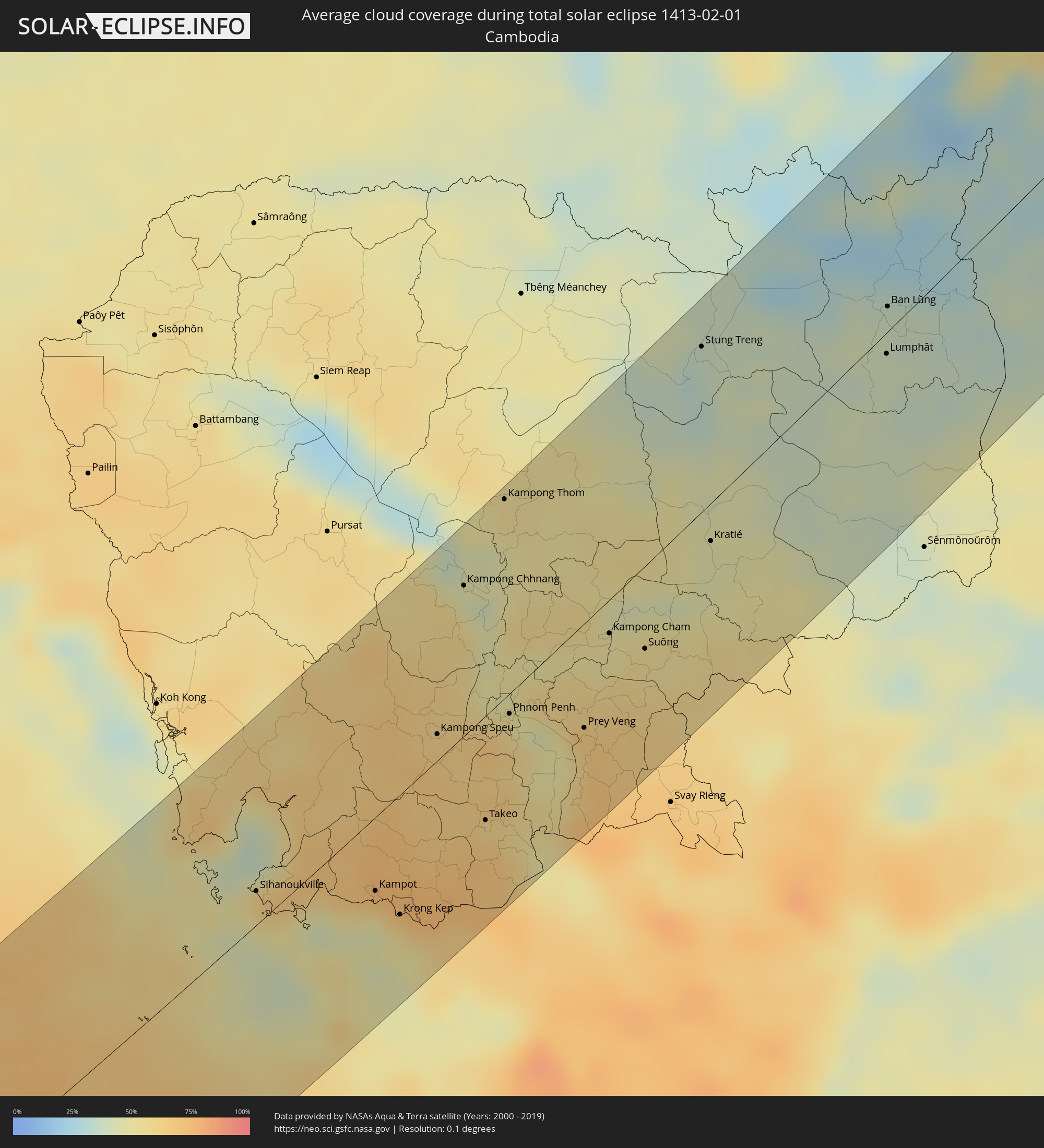 Cambodia
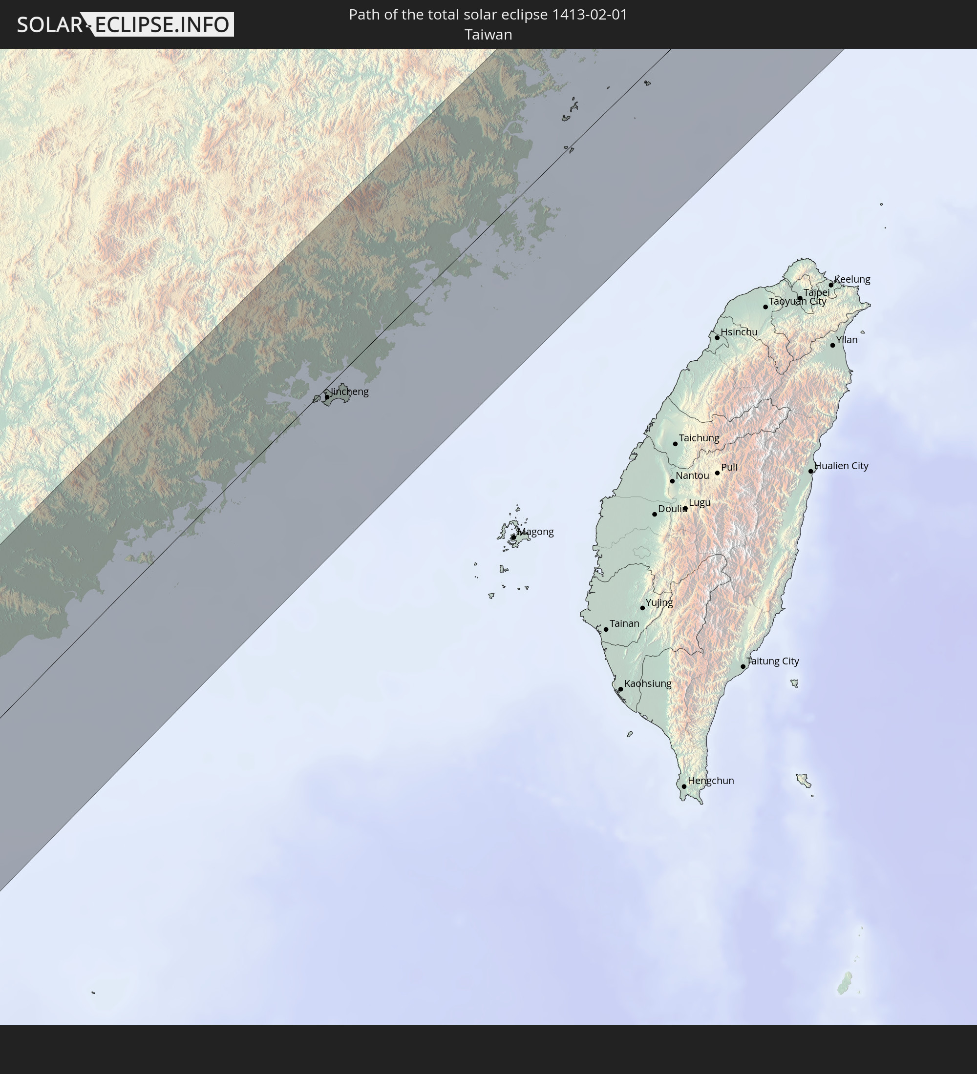
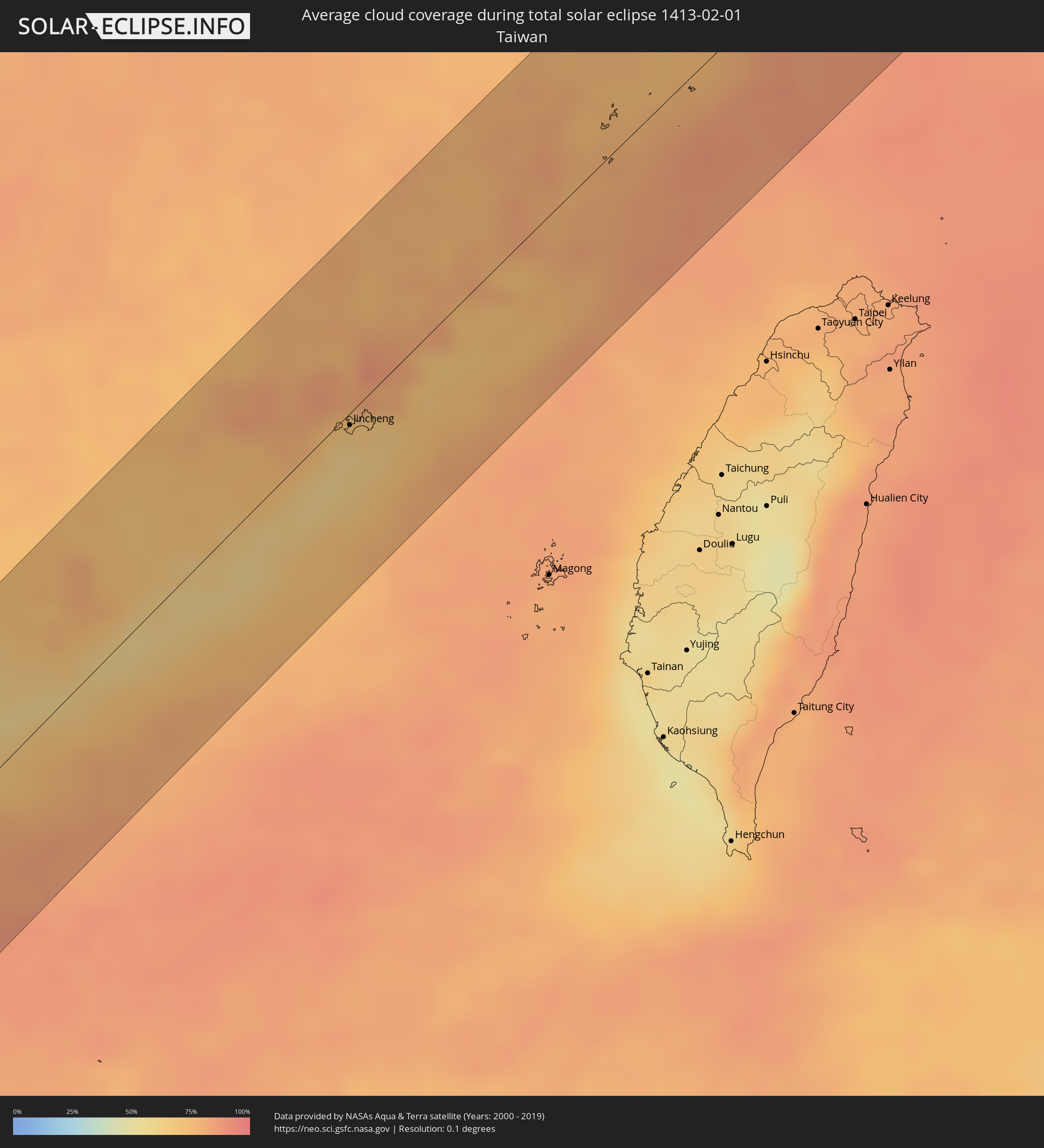 Taiwan
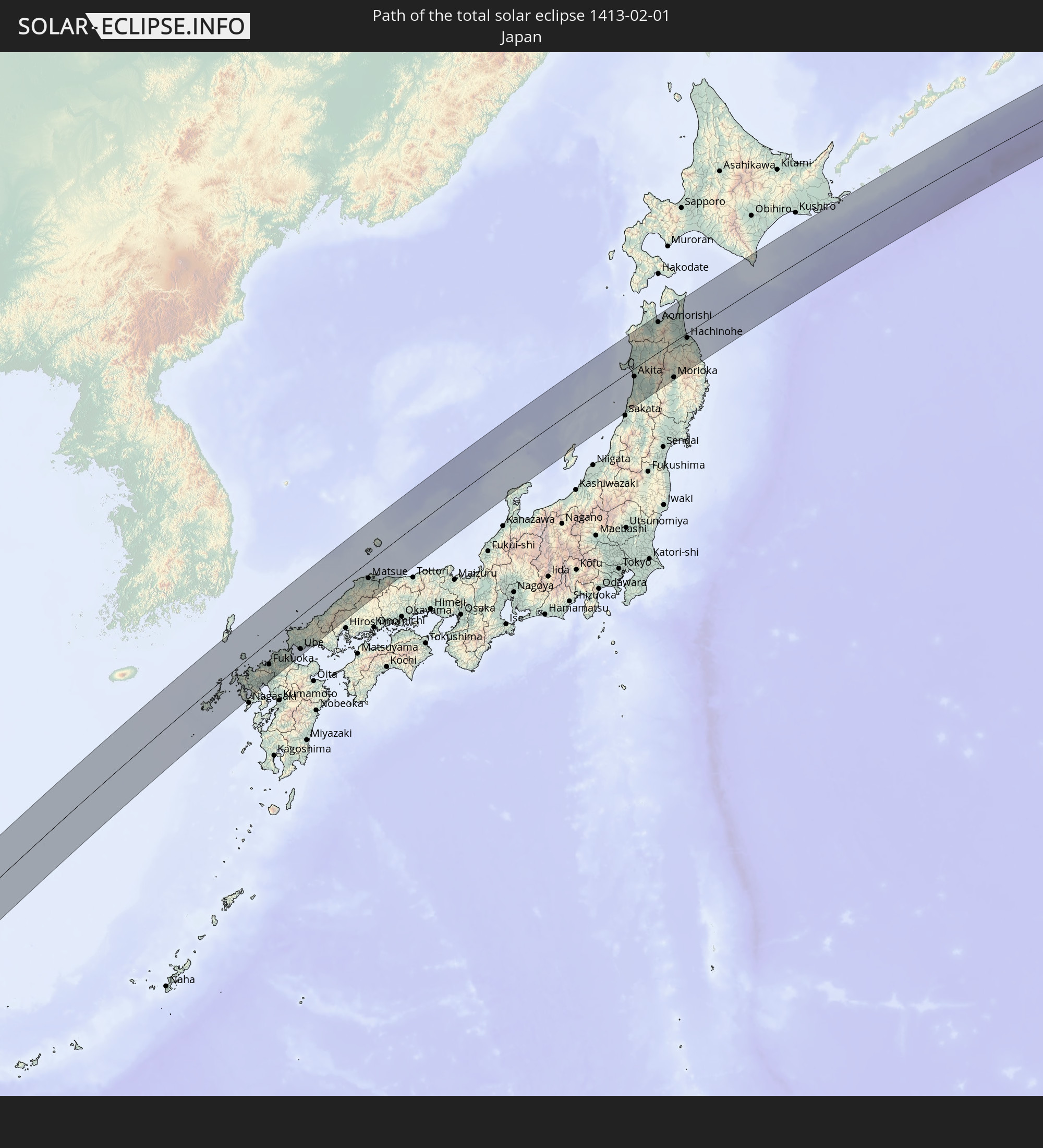
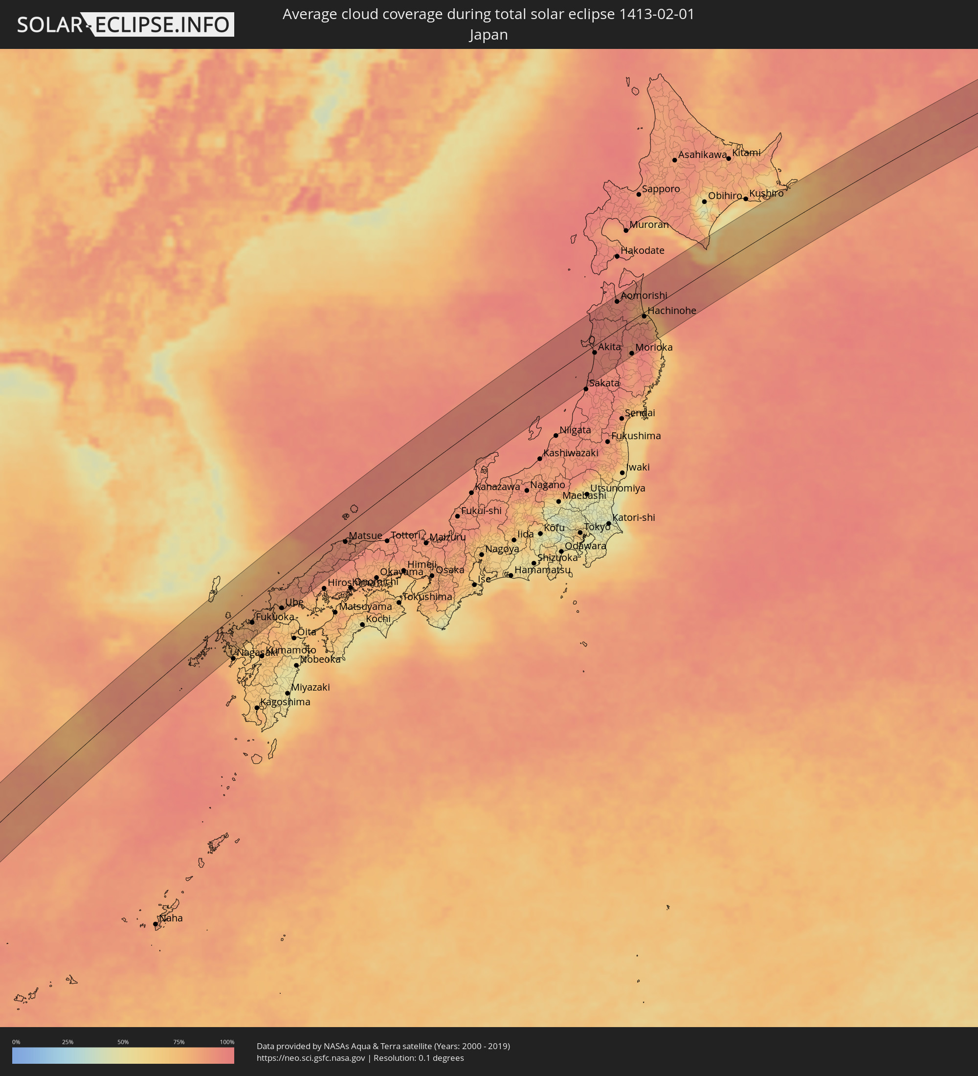 Japan
Japan
Cities inside the path of the eclipse
The following table shows all locations with a population of more than 5,000 inside the eclipse path. Cities which have more than 100,000 inhabitants are marked bold. A click at the locations opens a detailed map.
| City | Type | Eclipse duration | Local time of max. eclipse | Distance to central line | Ø Cloud coverage |
|
Sigli, Aceh
|
total | - | 11:26:31 UTC+07:07 | 67 km | 64% |
|
Meulaboh, Aceh
|
total | - | 11:24:48 UTC+07:07 | 60 km | 61% |
|
Reuleuet, Aceh
|
total | - | 11:26:58 UTC+07:07 | 32 km | 82% |
|
Bireun, Aceh
|
total | - | 11:27:55 UTC+07:07 | 5 km | 80% |
|
Lhokseumawe, Aceh
|
total | - | 11:28:55 UTC+07:07 | 25 km | 81% |
|
Saladan, Krabi
|
total | - | 11:12:21 UTC+06:42 | 74 km | 52% |
|
Ko Lanta, Krabi
|
total | - | 11:12:20 UTC+06:42 | 64 km | 50% |
|
Kantang, Trang
|
total | - | 11:13:06 UTC+06:42 | 24 km | 59% |
|
Trang, Trang
|
total | - | 11:13:35 UTC+06:42 | 31 km | 61% |
|
Huai Yot, Trang
|
total | - | 11:14:02 UTC+06:42 | 50 km | 68% |
|
Thung Song, Nakhon Si Thammarat
|
total | - | 11:14:48 UTC+06:42 | 80 km | 77% |
|
Pantai Cenang, Perlis
|
total | - | 11:24:59 UTC+06:55 | 89 km | 56% |
|
Padang Mat Sirat, Kedah
|
total | - | 11:25:06 UTC+06:55 | 84 km | 55% |
|
Ayer Hangat, Kedah
|
total | - | 11:25:26 UTC+06:55 | 84 km | 52% |
|
Kuah, Kedah
|
total | - | 11:25:19 UTC+06:55 | 94 km | 51% |
|
Ron Phibun, Nakhon Si Thammarat
|
total | - | 11:15:14 UTC+06:42 | 69 km | 85% |
|
Nakhon Si Thammarat, Nakhon Si Thammarat
|
total | - | 11:15:56 UTC+06:42 | 83 km | 82% |
|
Satun, Satun
|
total | - | 11:13:00 UTC+06:42 | 82 km | 60% |
|
Phatthalung, Phatthalung
|
total | - | 11:14:46 UTC+06:42 | 5 km | 80% |
|
Pak Phanang, Nakhon Si Thammarat
|
total | - | 11:16:20 UTC+06:42 | 60 km | 65% |
|
Ranot, Songkhla
|
total | - | 11:15:36 UTC+06:42 | 2 km | 71% |
|
Hat Yai, Songkhla
|
total | - | 11:14:36 UTC+06:42 | 76 km | 79% |
|
Ban Mai, Songkhla
|
total | - | 11:15:07 UTC+06:42 | 63 km | 68% |
|
Na Mom, Songkhla
|
total | - | 11:14:42 UTC+06:42 | 86 km | 74% |
|
Songkhla, Songkhla
|
total | - | 11:15:13 UTC+06:42 | 67 km | 66% |
|
Sihanoukville, Preah Sihanouk
|
total | - | 11:27:51 UTC+06:42 | 15 km | 52% |
|
Dương Đông, Kiến Giang
|
total | - | 11:52:44 UTC+07:06 | 49 km | 54% |
|
Kampot, Kampot
|
total | - | 11:29:19 UTC+06:42 | 33 km | 54% |
|
Krong Kep, Kep
|
total | - | 11:29:23 UTC+06:42 | 53 km | 53% |
|
Hà Tiên, Kiến Giang
|
total | - | 11:54:12 UTC+07:06 | 74 km | 58% |
|
Kampong Speu, Kampong Speu
|
total | - | 11:31:31 UTC+06:42 | 12 km | 63% |
|
Kampong Chhnang, Kampong Chhnang
|
total | - | 11:33:12 UTC+06:42 | 66 km | 45% |
|
Phumĭ Véal Srê, Takeo
|
total | - | 11:31:16 UTC+06:42 | 46 km | 66% |
|
Takeo, Takeo
|
total | - | 11:31:18 UTC+06:42 | 46 km | 66% |
|
Kampong Thom, Kampong Thom
|
total | - | 11:34:29 UTC+06:42 | 86 km | 55% |
|
Phnom Penh, Phnom Penh
|
total | - | 11:32:35 UTC+06:42 | 9 km | 60% |
|
Ta Khmau, Kandal
|
total | - | 11:32:31 UTC+06:42 | 18 km | 58% |
|
Prey Veng, Prey Veng
|
total | - | 11:33:21 UTC+06:42 | 45 km | 61% |
|
Kampong Cham, Kampong Cham
|
total | - | 11:34:31 UTC+06:42 | 15 km | 51% |
|
Suŏng, Tboung Khmum
|
total | - | 11:34:48 UTC+06:42 | 36 km | 56% |
|
Stung Treng, Stung Treng
|
total | - | 11:38:12 UTC+06:42 | 71 km | 37% |
|
Kratié, Kratie
|
total | - | 11:36:34 UTC+06:42 | 16 km | 46% |
|
Lumphăt, Ratanakiri
|
total | - | 11:40:19 UTC+06:42 | 9 km | 40% |
|
Ban Lŭng, Ratanakiri
|
total | - | 11:40:44 UTC+06:42 | 11 km | 39% |
|
Pleiku, Gia Lai
|
total | - | 12:07:53 UTC+07:06 | 47 km | 31% |
|
Kon Tum, Kon Tum
|
total | - | 12:08:30 UTC+07:06 | 18 km | 31% |
|
Hội An, Quảng Nam
|
total | - | 12:11:38 UTC+07:06 | 77 km | 74% |
|
Tam Kỳ, Quảng Nam
|
total | - | 12:11:26 UTC+07:06 | 42 km | 73% |
|
Quảng Ngãi, Quảng Ngãi
|
total | - | 12:11:22 UTC+07:06 | 18 km | 76% |
|
Shanwei, Guangdong
|
total | - | 13:27:58 UTC+08:00 | 81 km | 62% |
|
Donghai, Guangdong
|
total | - | 13:28:40 UTC+08:00 | 72 km | 64% |
|
Jieshi, Guangdong
|
total | - | 13:28:50 UTC+08:00 | 48 km | 58% |
|
Jiazi, Guangdong
|
total | - | 13:29:20 UTC+08:00 | 36 km | 63% |
|
Puning, Guangdong
|
total | - | 13:30:00 UTC+08:00 | 62 km | 73% |
|
Huicheng, Guangdong
|
total | - | 13:29:53 UTC+08:00 | 32 km | 64% |
|
Jieyang, Guangdong
|
total | - | 13:30:36 UTC+08:00 | 66 km | 73% |
|
Haimen, Guangdong
|
total | - | 13:30:36 UTC+08:00 | 21 km | 65% |
|
Chaozhou, Guangdong
|
total | - | 13:31:09 UTC+08:00 | 56 km | 80% |
|
Shantou, Guangdong
|
total | - | 13:30:59 UTC+08:00 | 27 km | 72% |
|
Huanggang, Guangdong
|
total | - | 13:31:48 UTC+08:00 | 30 km | 70% |
|
Zhangzhou, Fujian
|
total | - | 13:33:48 UTC+08:00 | 48 km | 78% |
|
Shima, Fujian
|
total | - | 13:33:59 UTC+08:00 | 32 km | 77% |
|
Xiamen, Fujian
|
total | - | 13:34:28 UTC+08:00 | 15 km | 73% |
|
Jincheng, Fukien
|
total | - | 13:34:48 UTC+08:00 | 5 km | 62% |
|
Ximei, Fujian
|
total | - | 13:35:29 UTC+08:00 | 33 km | 82% |
|
Quanzhou, Fujian
|
total | - | 13:35:43 UTC+08:00 | 13 km | 83% |
|
Luoyang, Fujian
|
total | - | 13:35:55 UTC+08:00 | 10 km | 81% |
|
Yongning, Fujian
|
total | - | 13:35:39 UTC+08:00 | 13 km | 73% |
|
Dazuo, Fujian
|
total | - | 13:36:18 UTC+08:00 | 16 km | 69% |
|
Putian, Fujian
|
total | - | 13:36:56 UTC+08:00 | 24 km | 79% |
|
Jiangkou, Fujian
|
total | - | 13:37:16 UTC+08:00 | 15 km | 77% |
|
Fuzhou, Fujian
|
total | - | 13:38:00 UTC+08:00 | 53 km | 79% |
|
Fuqing, Fujian
|
total | - | 13:37:47 UTC+08:00 | 21 km | 82% |
|
Tantou, Fujian
|
total | - | 13:38:25 UTC+08:00 | 30 km | 82% |
|
Jinxiang, Zhejiang
|
total | - | 13:41:14 UTC+08:00 | 71 km | 78% |
|
Sasebo, Nagasaki
|
total | - | 14:56:42 UTC+09:00 | 42 km | 78% |
|
Imarichō-kō, Saga Prefecture
|
total | - | 14:56:55 UTC+09:00 | 41 km | 80% |
|
Ōmura, Nagasaki
|
total | - | 14:56:51 UTC+09:00 | 76 km | 72% |
|
Karatsu, Saga Prefecture
|
total | - | 14:57:05 UTC+09:00 | 32 km | 80% |
|
Maebaru-chūō, Fukuoka
|
total | - | 14:57:23 UTC+09:00 | 36 km | 77% |
|
Saga, Saga Prefecture
|
total | - | 14:57:22 UTC+09:00 | 69 km | 69% |
|
Fukuoka, Fukuoka
|
total | - | 14:57:38 UTC+09:00 | 45 km | 80% |
|
Koga, Fukuoka
|
total | - | 14:57:45 UTC+09:00 | 36 km | 81% |
|
Kurume, Fukuoka
|
total | - | 14:57:38 UTC+09:00 | 75 km | 74% |
|
Iizuka, Fukuoka
|
total | - | 14:57:56 UTC+09:00 | 57 km | 79% |
|
Kitakyushu, Fukuoka
|
total | - | 14:58:12 UTC+09:00 | 48 km | 83% |
|
Yukuhashi, Fukuoka
|
total | - | 14:58:18 UTC+09:00 | 67 km | 73% |
|
Ube, Yamaguchi
|
total | - | 14:58:39 UTC+09:00 | 64 km | 72% |
|
Yamaguchi, Yamaguchi
|
total | - | 14:58:58 UTC+09:00 | 55 km | 82% |
|
Hōfu, Yamaguchi
|
total | - | 14:59:01 UTC+09:00 | 73 km | 80% |
|
Izumo, Shimane
|
total | - | 15:00:38 UTC+09:00 | 26 km | 88% |
|
Matsue, Shimane
|
total | - | 15:00:57 UTC+09:00 | 32 km | 87% |
|
Yonago, Tottori
|
total | - | 15:01:13 UTC+09:00 | 52 km | 89% |
|
Noshiro, Akita
|
total | - | 15:07:18 UTC+09:00 | 33 km | 94% |
|
Akita, Akita
|
total | - | 15:07:23 UTC+09:00 | 16 km | 93% |
|
Hirosaki, Aomori
|
total | - | 15:07:36 UTC+09:00 | 48 km | 90% |
|
Ōdate, Akita
|
total | - | 15:07:41 UTC+09:00 | 14 km | 91% |
|
Aomorishi, Aomori
|
total | - | 15:07:45 UTC+09:00 | 56 km | 91% |
|
Morioka, Iwate
|
total | - | 15:08:08 UTC+09:00 | 67 km | 88% |
|
Hachinohe, Aomori
|
total | - | 15:08:19 UTC+09:00 | 9 km | 86% |