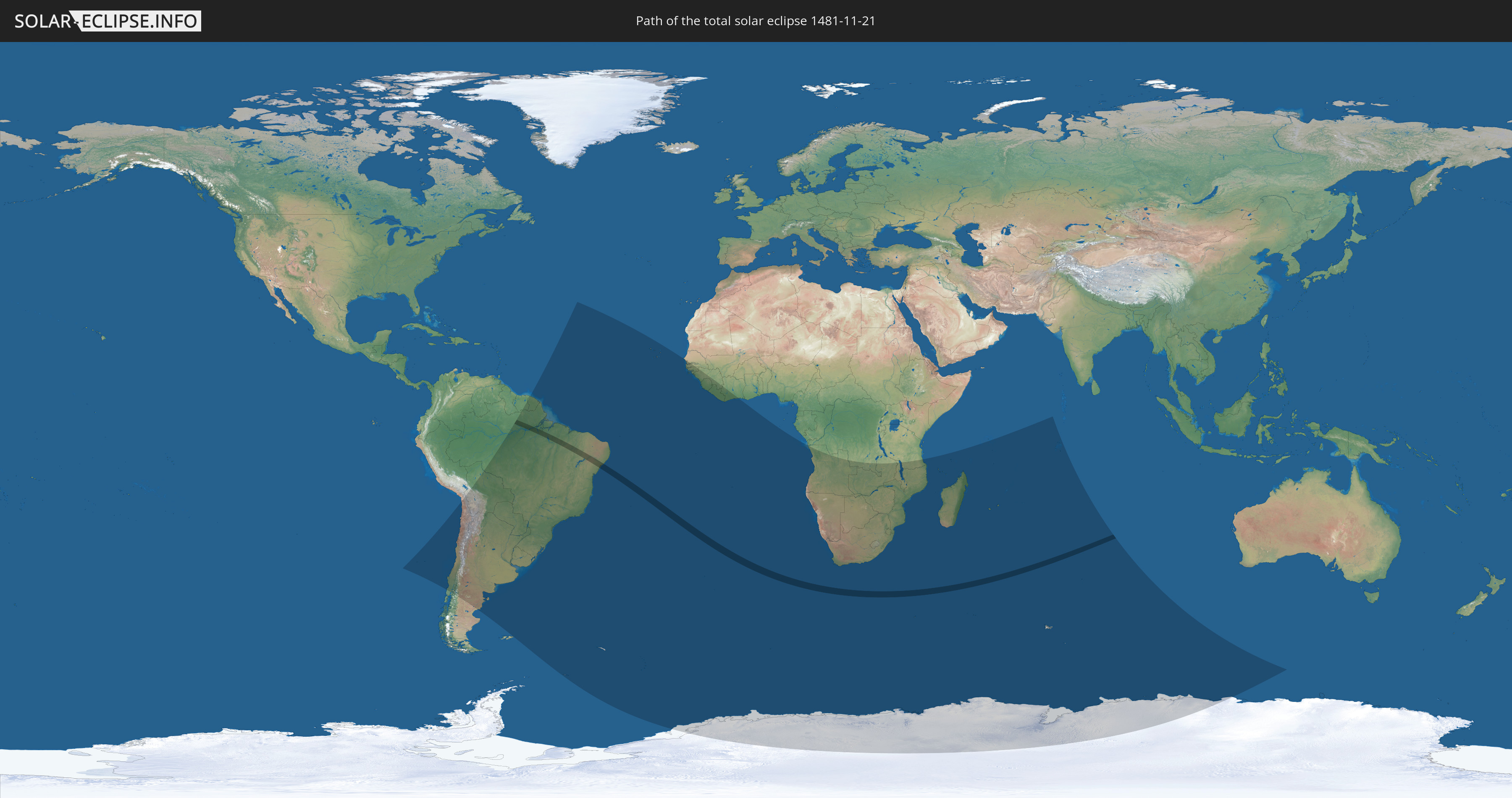
Total solar eclipse of 11/21/1481
| Day of week: | Monday |
| Maximum duration of eclipse: | 03m53s |
| Maximum width of eclipse path: | 165 km |
| Saros cycle: | 124 |
| Coverage: | 100% |
| Magnitude: | 1.0479 |
| Gamma: | -0.2617 |
Wo kann man die Sonnenfinsternis vom 11/21/1481 sehen?
Die Sonnenfinsternis am 11/21/1481 kann man in 42 Ländern als partielle Sonnenfinsternis beobachten.
Der Finsternispfad verläuft durch ein Land. Nur in diesem Land ist sie als total Sonnenfinsternis zu sehen.
In den folgenden Ländern ist die Sonnenfinsternis total zu sehen
 Brazil
In den folgenden Ländern ist die Sonnenfinsternis partiell zu sehen
 Antarctica
 Chile
Chile
 Brazil
 Argentina
 Bolivia
 Paraguay
 Falkland Islands
 Uruguay
 Suriname
 French Guiana
 South Georgia and the South Sandwich Islands
 Cabo Verde
 Senegal
 The Gambia
 Guinea-Bissau
 Guinea
 Saint Helena, Ascension and Tristan da Cunha
 Sierra Leone
 Liberia
 Ivory Coast
 Bouvet Island
 Angola
 Namibia
 Democratic Republic of the Congo
 South Africa
 Botswana
 Zambia
 Zimbabwe
 Lesotho
 Tanzania
 Mozambique
 Swaziland
 Malawi
 French Southern and Antarctic Lands
 Madagascar
 Comoros
 Mayotte
 Seychelles
 Réunion
 Mauritius
 British Indian Ocean Territory
 Heard Island and McDonald Islands
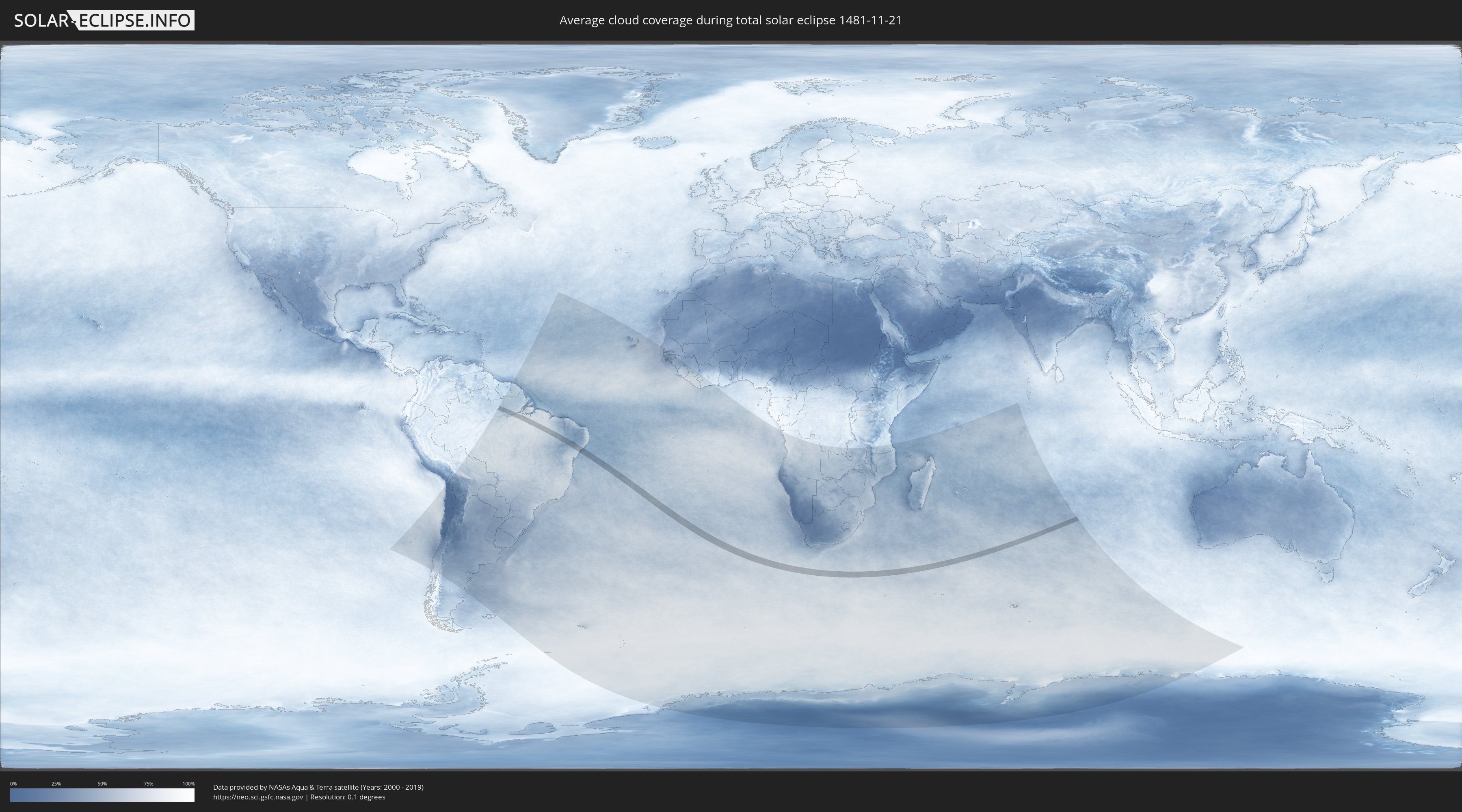
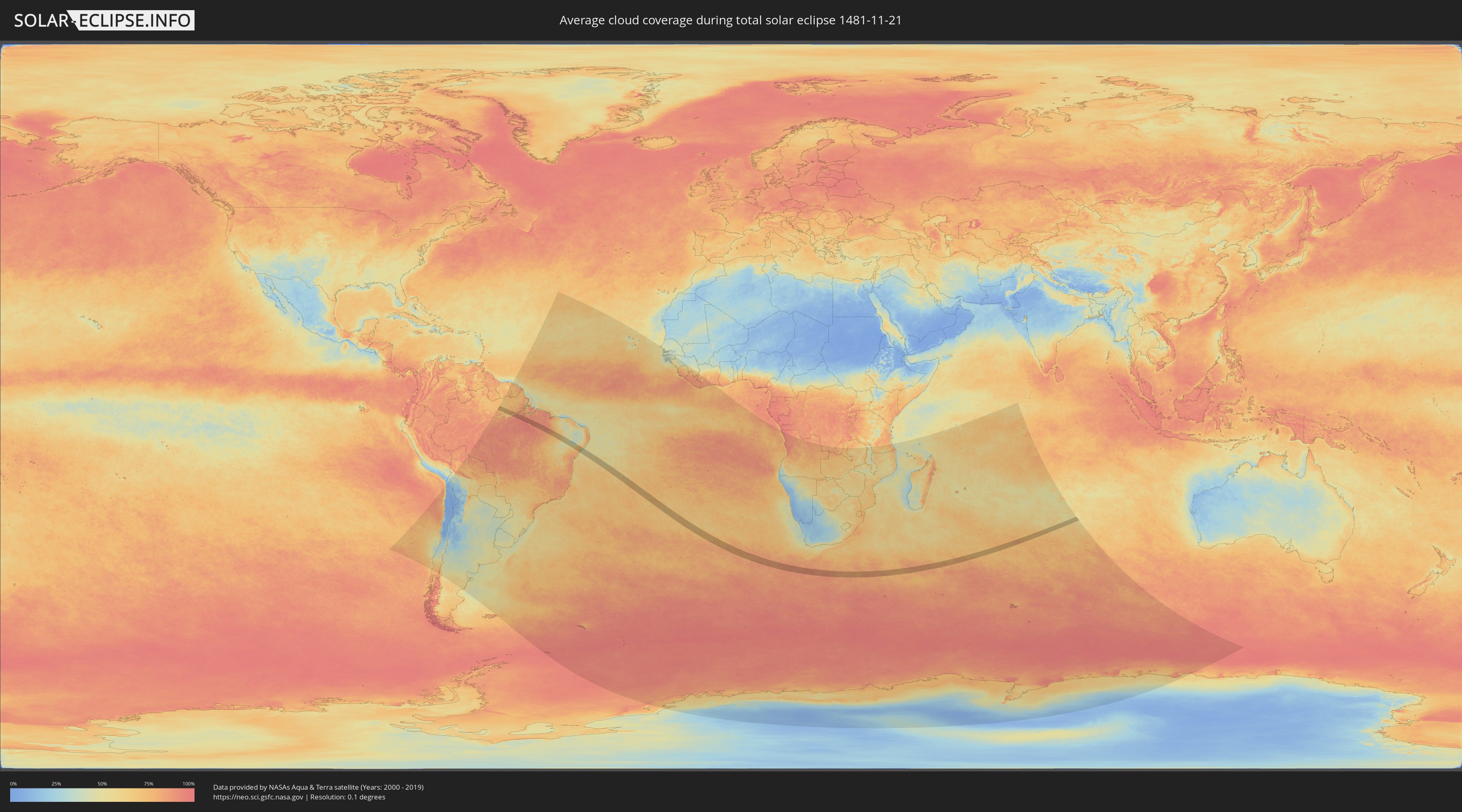
How will be the weather during the total solar eclipse on 11/21/1481?
Where is the best place to see the total solar eclipse of 11/21/1481?
The following maps show the average cloud coverage for the day of the total solar eclipse.
With the help of these maps, it is possible to find the place along the eclipse path, which has the best
chance of a cloudless sky.
Nevertheless, you should consider local circumstances and inform about the weather of your chosen
observation site.
The data is provided by NASAs satellites
AQUA and TERRA.
The cloud maps are averaged over a period of 19 years (2000 - 2019).
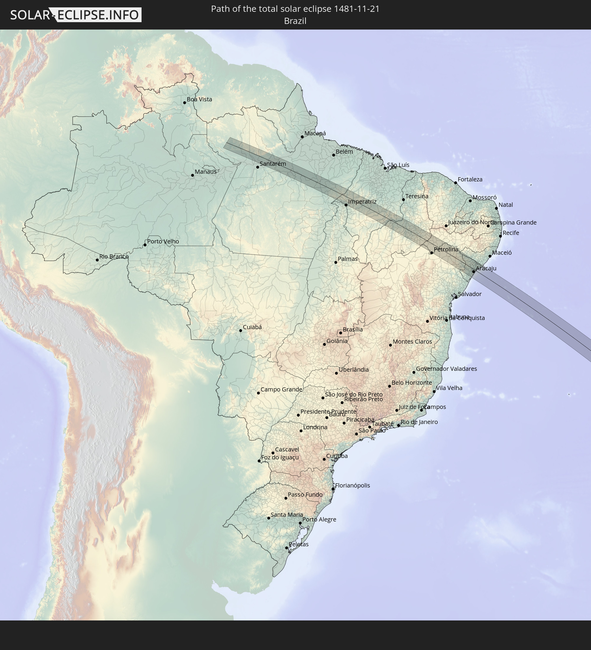
Detailed country maps
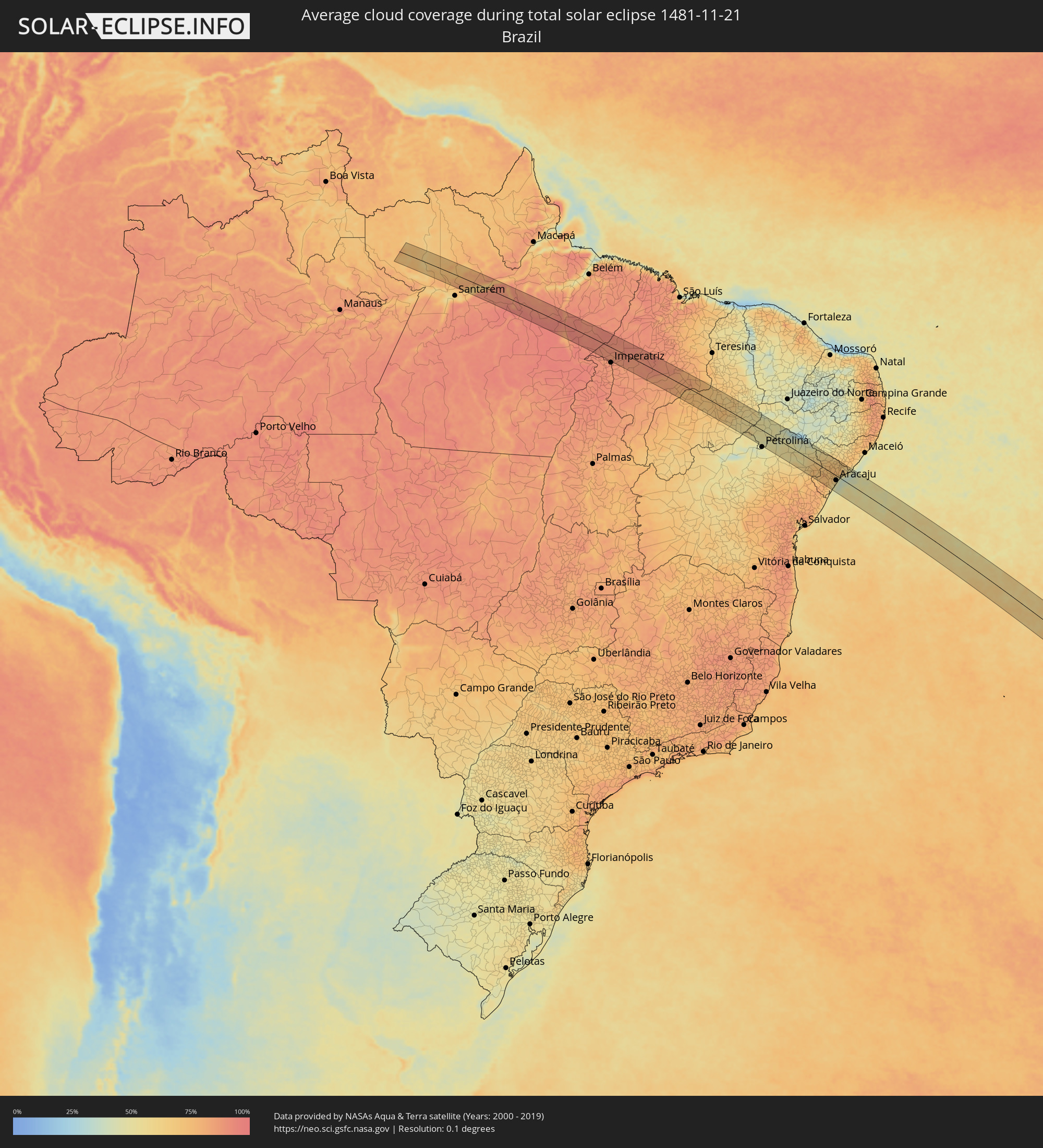 Brazil
Cities inside the path of the eclipse
The following table shows all locations with a population of more than 5,000 inside the eclipse path. Cities which have more than 100,000 inhabitants are marked bold. A click at the locations opens a detailed map.
| City | Type | Eclipse duration | Local time of max. eclipse | Distance to central line | Ø Cloud coverage |
|
Alenquer, Pará
|
total | - | 06:24:47 UTC-03:13 | 50 km | 76% |
|
Monte Alegre, Pará
|
total | - | 06:24:43 UTC-03:13 | 27 km | 65% |
|
Prainha, Pará
|
total | - | 06:24:28 UTC-03:13 | 20 km | 62% |
|
Senador José Porfírio, Pará
|
total | - | 06:24:50 UTC-03:13 | 9 km | 86% |
|
Tucuruí, Pará
|
total | - | 06:25:32 UTC-03:13 | 2 km | 90% |
|
Amarante do Maranhão, Maranhão
|
total | - | 07:06:57 UTC-02:34 | 36 km | 86% |
|
Grajaú, Maranhão
|
total | - | 07:07:12 UTC-02:34 | 30 km | 89% |
|
Barra do Corda, Maranhão
|
total | - | 07:06:58 UTC-02:34 | 48 km | 87% |
|
Mirador, Maranhão
|
total | - | 07:07:51 UTC-02:34 | 8 km | 78% |
|
Colinas, Maranhão
|
total | - | 07:07:32 UTC-02:34 | 48 km | 78% |
|
Raposa, Maranhão
|
total | - | 07:08:00 UTC-02:34 | 3 km | 80% |
|
Pastos Bons, Maranhão
|
total | - | 07:08:06 UTC-02:34 | 1 km | 79% |
|
Paraibano, Maranhão
|
total | - | 07:07:57 UTC-02:34 | 22 km | 79% |
|
Passagem Franca, Maranhão
|
total | - | 07:07:44 UTC-02:34 | 58 km | 81% |
|
São João dos Patos, Maranhão
|
total | - | 07:08:03 UTC-02:34 | 31 km | 78% |
|
Itaueira, Piauí
|
total | - | 07:09:13 UTC-02:34 | 40 km | 69% |
|
Floriano, Piauí
|
total | - | 07:08:24 UTC-02:34 | 41 km | 71% |
|
Oeiras, Piauí
|
total | - | 07:08:47 UTC-02:34 | 64 km | 63% |
|
Simplício Mendes, Piauí
|
total | - | 07:09:39 UTC-02:34 | 4 km | 64% |
|
Curaçá, Bahia
|
total | - | 07:11:17 UTC-02:34 | 2 km | 46% |
|
Santa Maria da Boa Vista, Pernambuco
|
total | - | 07:25:31 UTC-02:19 | 21 km | 46% |
|
Uauá, Bahia
|
total | - | 07:12:19 UTC-02:34 | 58 km | 54% |
|
Jeremoabo, Bahia
|
total | - | 07:12:53 UTC-02:34 | 23 km | 59% |
|
Cícero Dantas, Bahia
|
total | - | 07:13:30 UTC-02:34 | 67 km | 68% |
|
Paulo Afonso, Bahia
|
total | - | 07:12:13 UTC-02:34 | 56 km | 46% |
|
Poço Verde, Sergipe
|
total | - | 07:13:41 UTC-02:34 | 66 km | 70% |
|
Delmiro Gouveia, Alagoas
|
total | - | 07:12:16 UTC-02:34 | 70 km | 49% |
|
Paripiranga, Bahia
|
total | - | 07:13:46 UTC-02:34 | 45 km | 70% |
|
Simão Dias, Sergipe
|
total | - | 07:13:51 UTC-02:34 | 47 km | 73% |
|
Canindé de São Francisco, Sergipe
|
total | - | 07:12:38 UTC-02:34 | 56 km | 61% |
|
Carira, Sergipe
|
total | - | 07:13:27 UTC-02:34 | 5 km | 71% |
|
Lagarto, Sergipe
|
total | - | 07:14:07 UTC-02:34 | 54 km | 78% |
|
Monte Alegre de Sergipe, Sergipe
|
total | - | 07:13:08 UTC-02:34 | 35 km | 67% |
|
Frei Paulo, Sergipe
|
total | - | 07:13:44 UTC-02:34 | 13 km | 74% |
|
Campo do Brito, Sergipe
|
total | - | 07:13:57 UTC-02:34 | 28 km | 75% |
|
Salgado, Sergipe
|
total | - | 07:14:18 UTC-02:34 | 55 km | 72% |
|
Pão de Açúcar, Alagoas
|
total | - | 07:12:51 UTC-02:34 | 68 km | 62% |
|
Itabaiana, Sergipe
|
total | - | 07:13:55 UTC-02:34 | 19 km | 73% |
|
Nossa Senhora da Glória, Sergipe
|
total | - | 07:13:24 UTC-02:34 | 25 km | 73% |
|
Ribeirópolis, Sergipe
|
total | - | 07:13:46 UTC-02:34 | 5 km | 71% |
|
Areia Branca, Sergipe
|
total | - | 07:14:03 UTC-02:34 | 20 km | 70% |
|
Malhador, Sergipe
|
total | - | 07:13:56 UTC-02:34 | 10 km | 73% |
|
Porto da Folha, Sergipe
|
total | - | 07:13:06 UTC-02:34 | 62 km | 65% |
|
São Cristóvão, Sergipe
|
total | - | 07:14:23 UTC-02:34 | 38 km | 56% |
|
Nossa Senhora das Dores, Sergipe
|
total | - | 07:13:47 UTC-02:34 | 12 km | 74% |
|
Laranjeiras, Sergipe
|
total | - | 07:14:09 UTC-02:34 | 16 km | 63% |
|
Nossa Senhora do Socorro, Sergipe
|
total | - | 07:14:14 UTC-02:34 | 18 km | 54% |
|
Maruim, Sergipe
|
total | - | 07:14:06 UTC-02:34 | 4 km | 57% |
|
Aracaju, Sergipe
|
total | - | 07:14:19 UTC-02:34 | 20 km | 54% |
|
Santo Amaro das Brotas, Sergipe
|
total | - | 07:14:11 UTC-02:34 | 7 km | 52% |
|
Capela, Sergipe
|
total | - | 07:13:51 UTC-02:34 | 20 km | 74% |
|
Barra dos Coqueiros, Sergipe
|
total | - | 07:14:19 UTC-02:34 | 18 km | 43% |
|
Aquidabã, Sergipe
|
total | - | 07:13:36 UTC-02:34 | 42 km | 73% |
|
Japaratuba, Sergipe
|
total | - | 07:14:00 UTC-02:34 | 18 km | 57% |
|
Propriá, Sergipe
|
total | - | 07:13:36 UTC-02:34 | 60 km | 64% |
|
Porto Real do Colégio, Alagoas
|
total | - | 07:13:34 UTC-02:34 | 62 km | 64% |
|
Penedo, Alagoas
|
total | - | 07:13:47 UTC-02:34 | 67 km | 59% |
|
Neópolis, Sergipe
|
total | - | 07:13:49 UTC-02:34 | 65 km | 59% |
|
Piaçabuçu, Alagoas
|
total | - | 07:13:58 UTC-02:34 | 65 km | 47% |