Total solar eclipse of 09/21/1568
| Day of week: | Saturday |
| Maximum duration of eclipse: | 05m32s |
| Maximum width of eclipse path: | 204 km |
| Saros cycle: | 127 |
| Coverage: | 100% |
| Magnitude: | 1.0615 |
| Gamma: | 0.1619 |
Wo kann man die Sonnenfinsternis vom 09/21/1568 sehen?
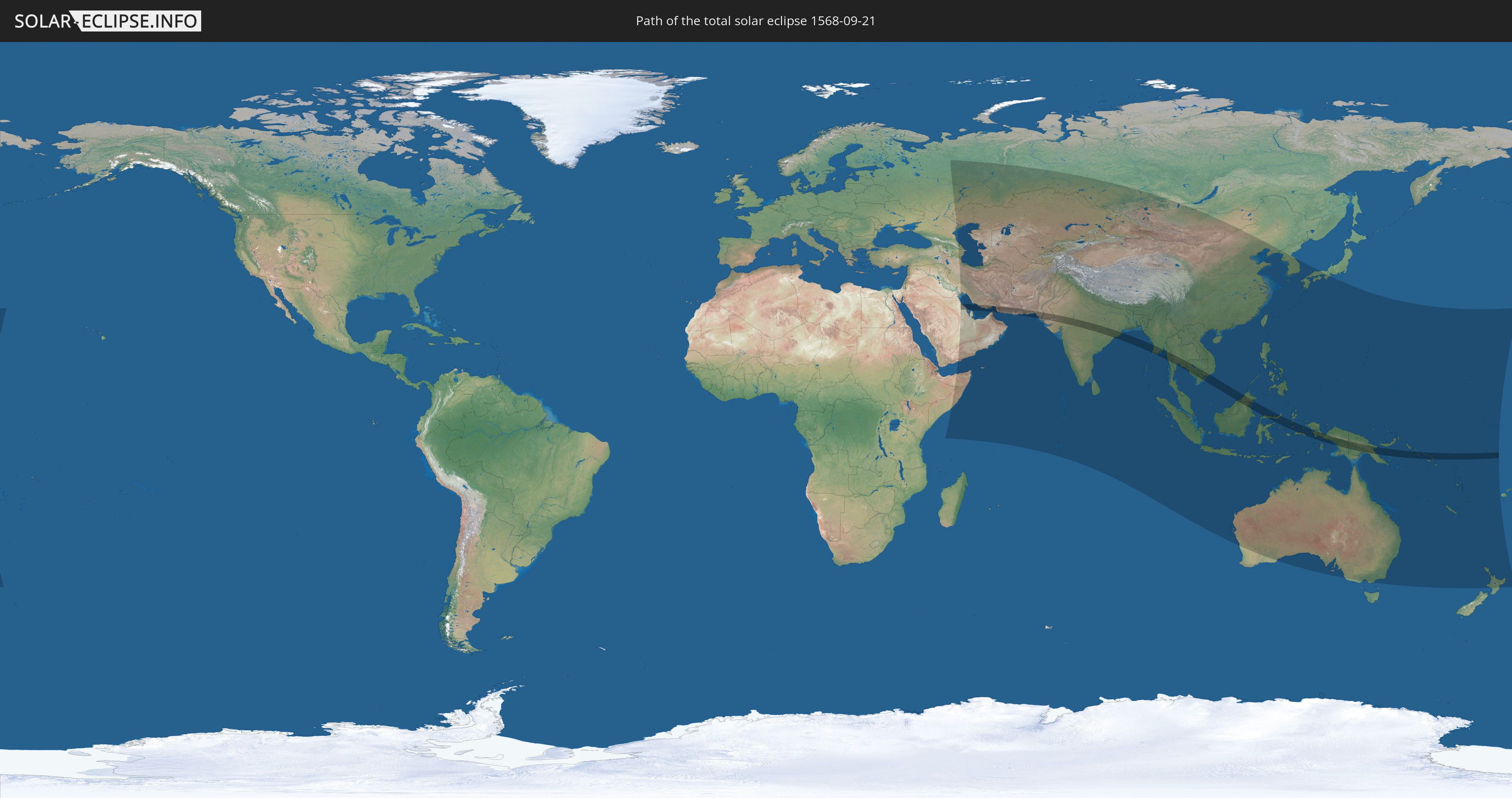
Die Sonnenfinsternis am 09/21/1568 kann man in 64 Ländern als partielle Sonnenfinsternis beobachten.
Der Finsternispfad verläuft durch 16 Länder. Nur in diesen Ländern ist sie als total Sonnenfinsternis zu sehen.
In den folgenden Ländern ist die Sonnenfinsternis total zu sehen
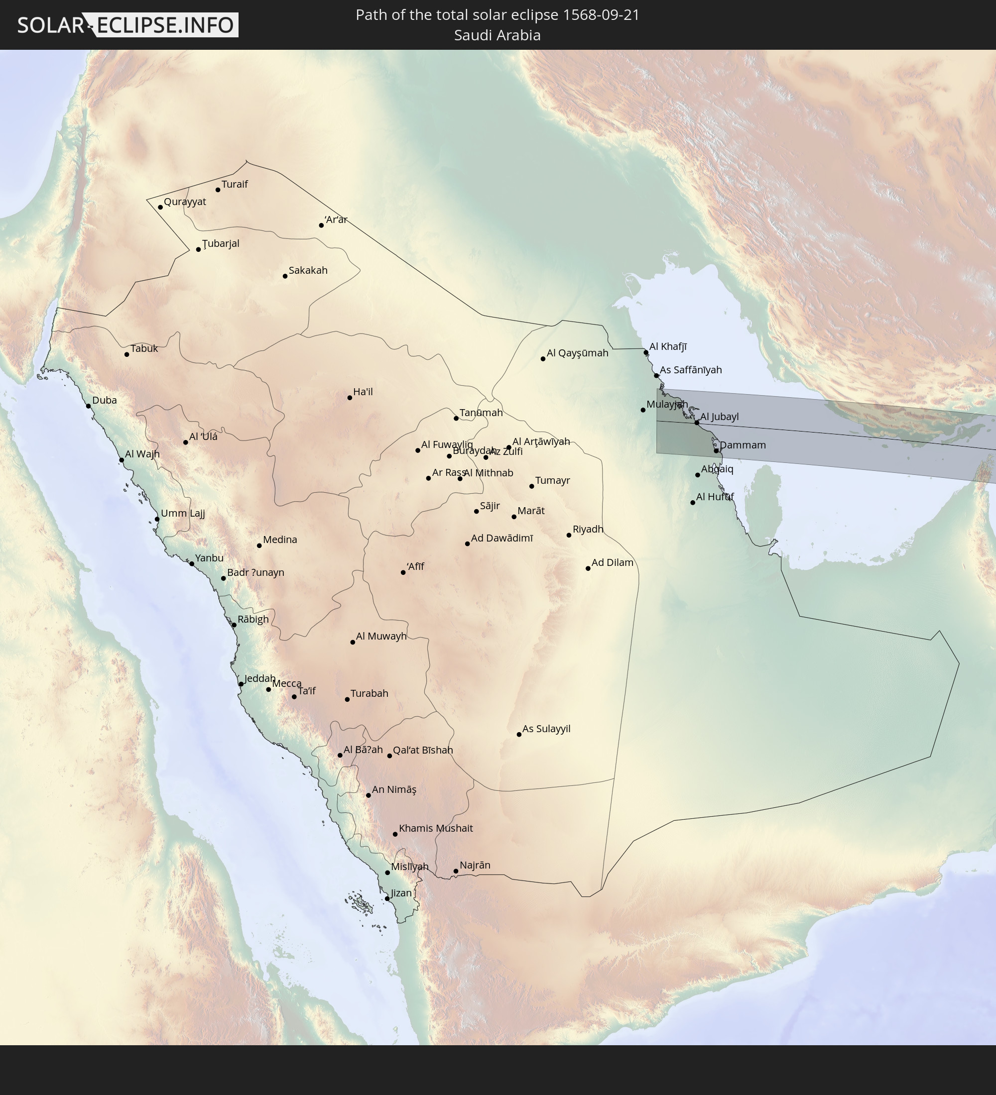 Saudi Arabia
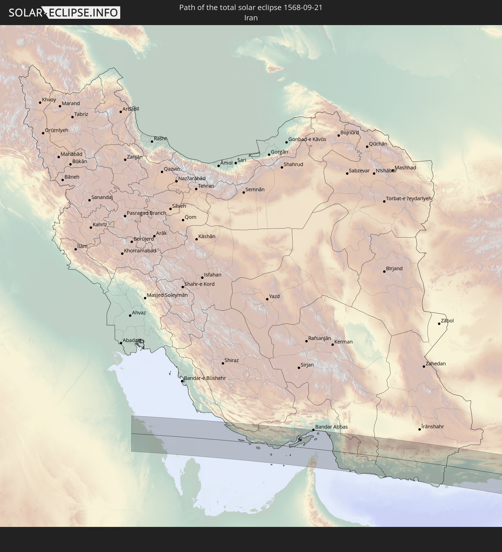 Iran
Iran
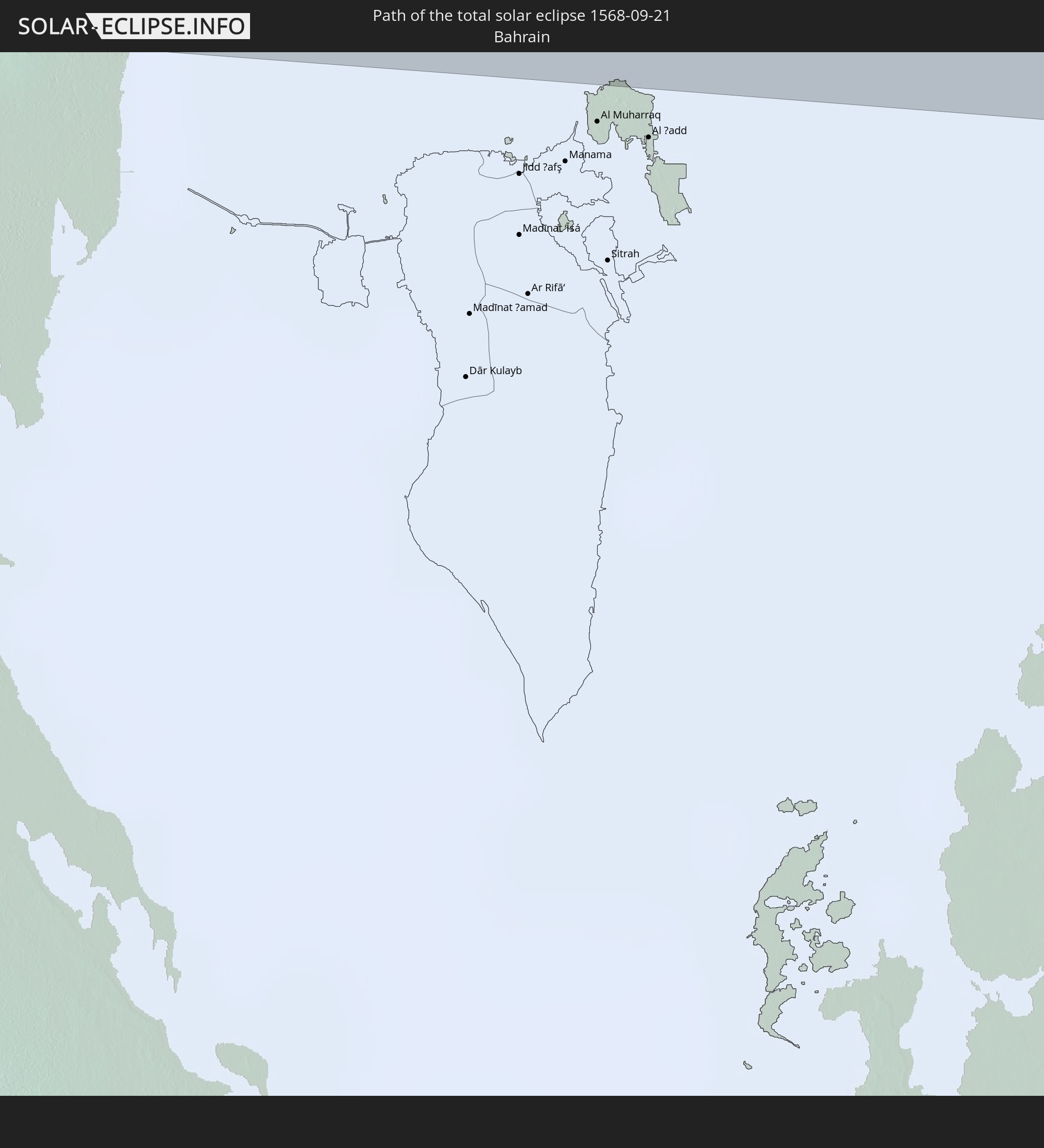 Bahrain
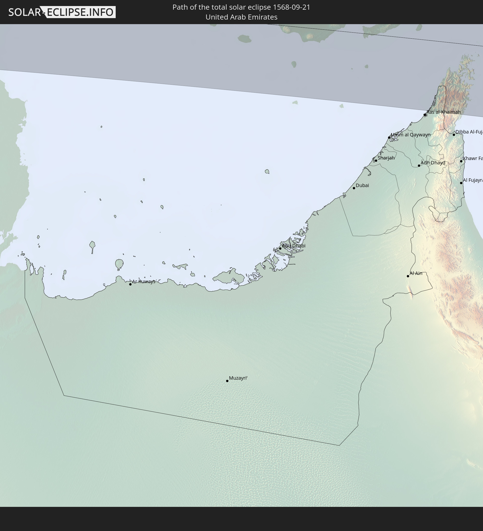 United Arab Emirates
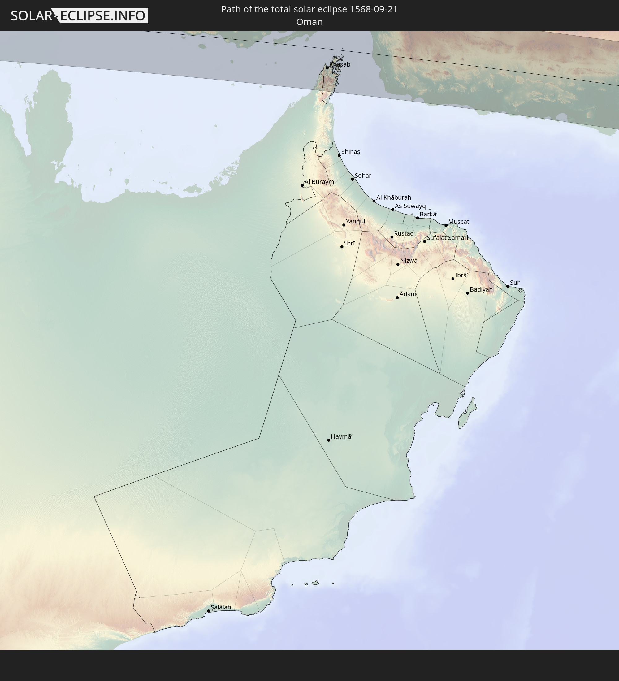 Oman
Oman
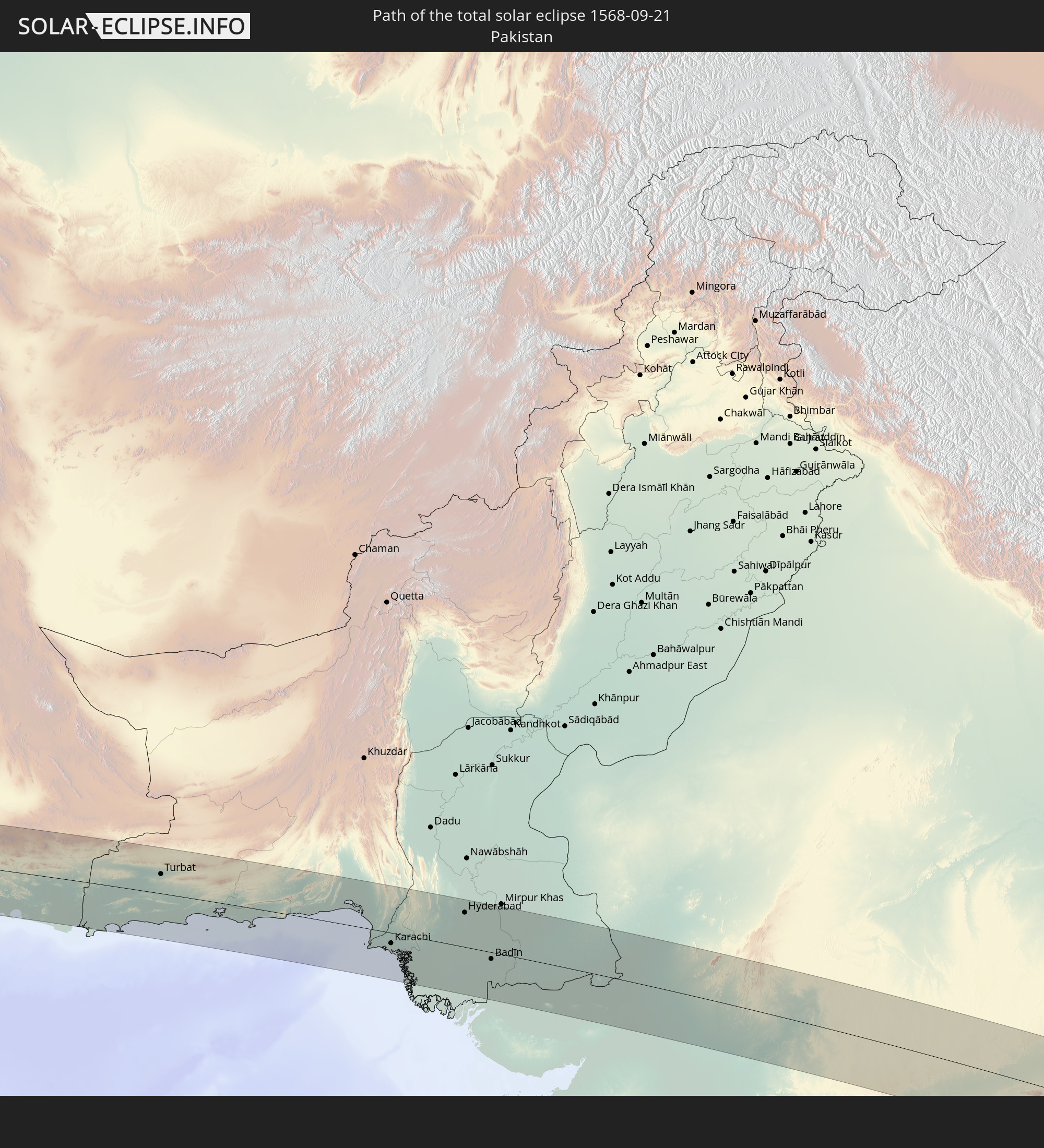 Pakistan
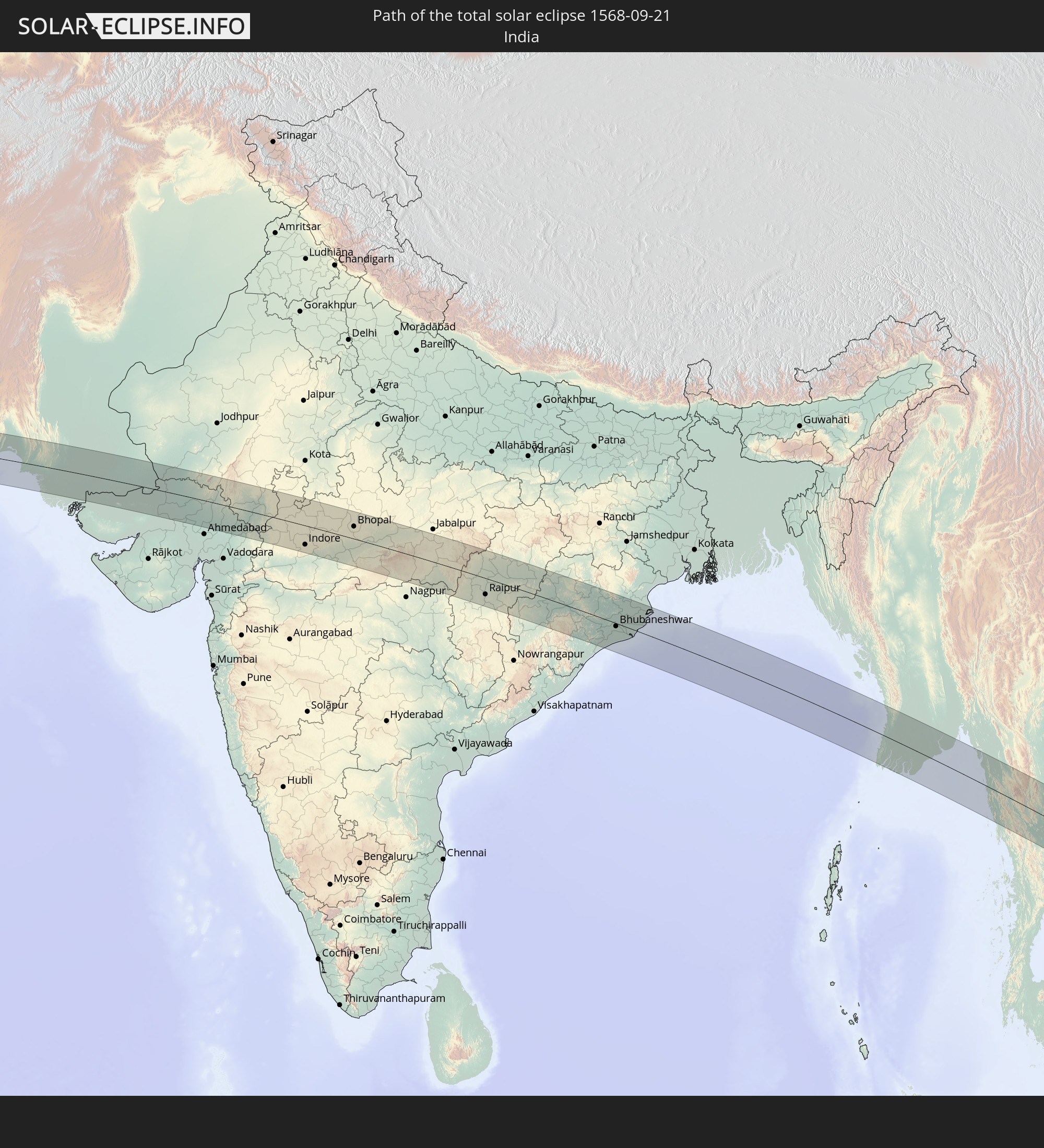 India
India
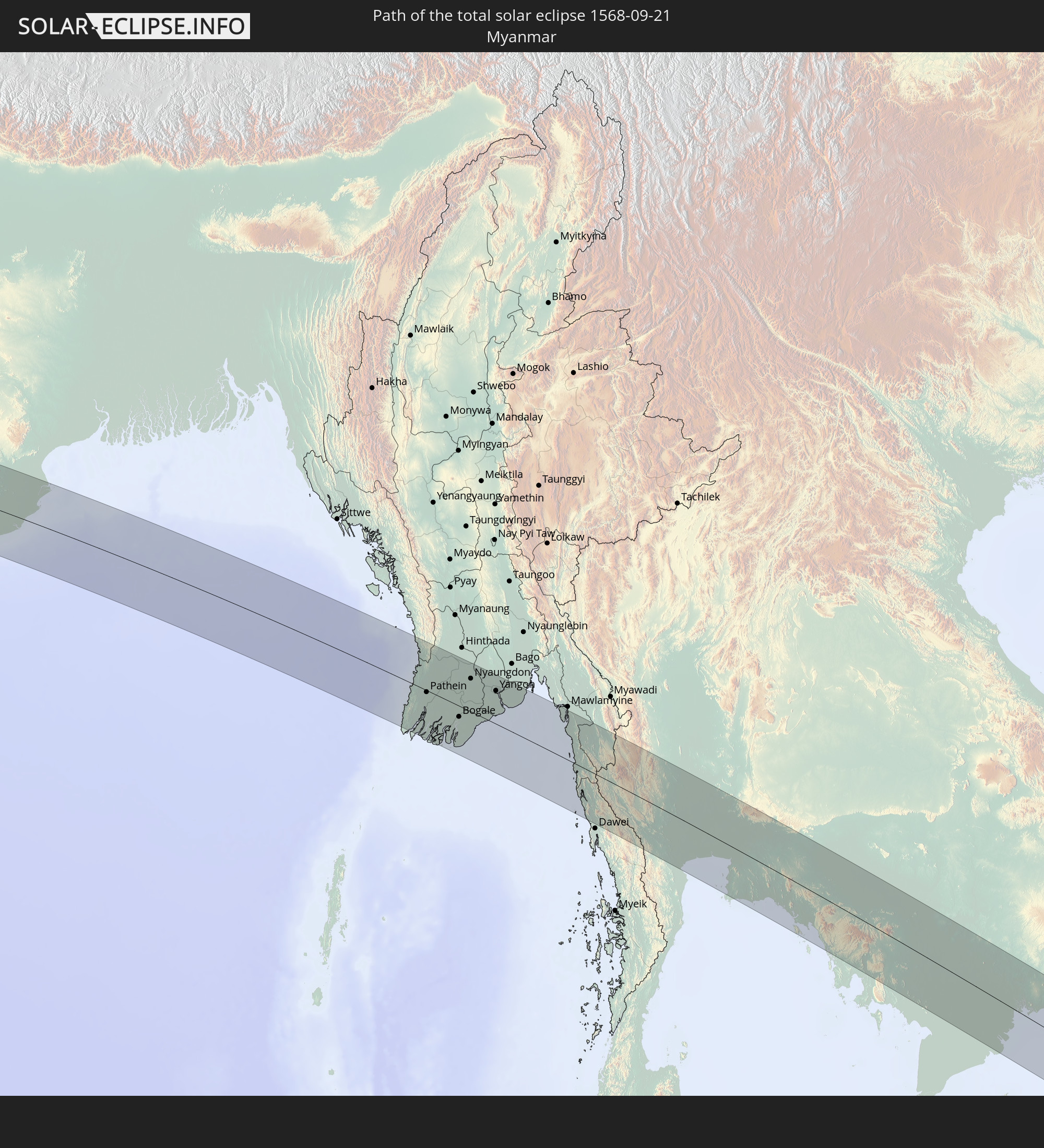 Myanmar
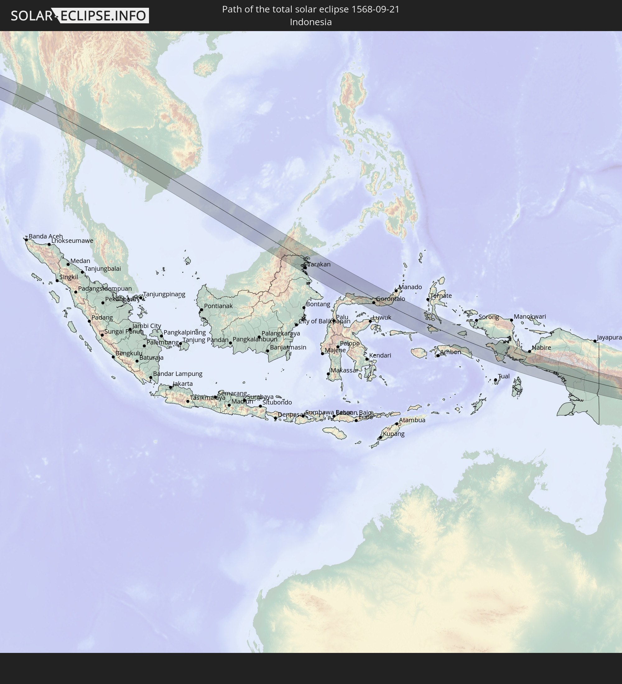 Indonesia
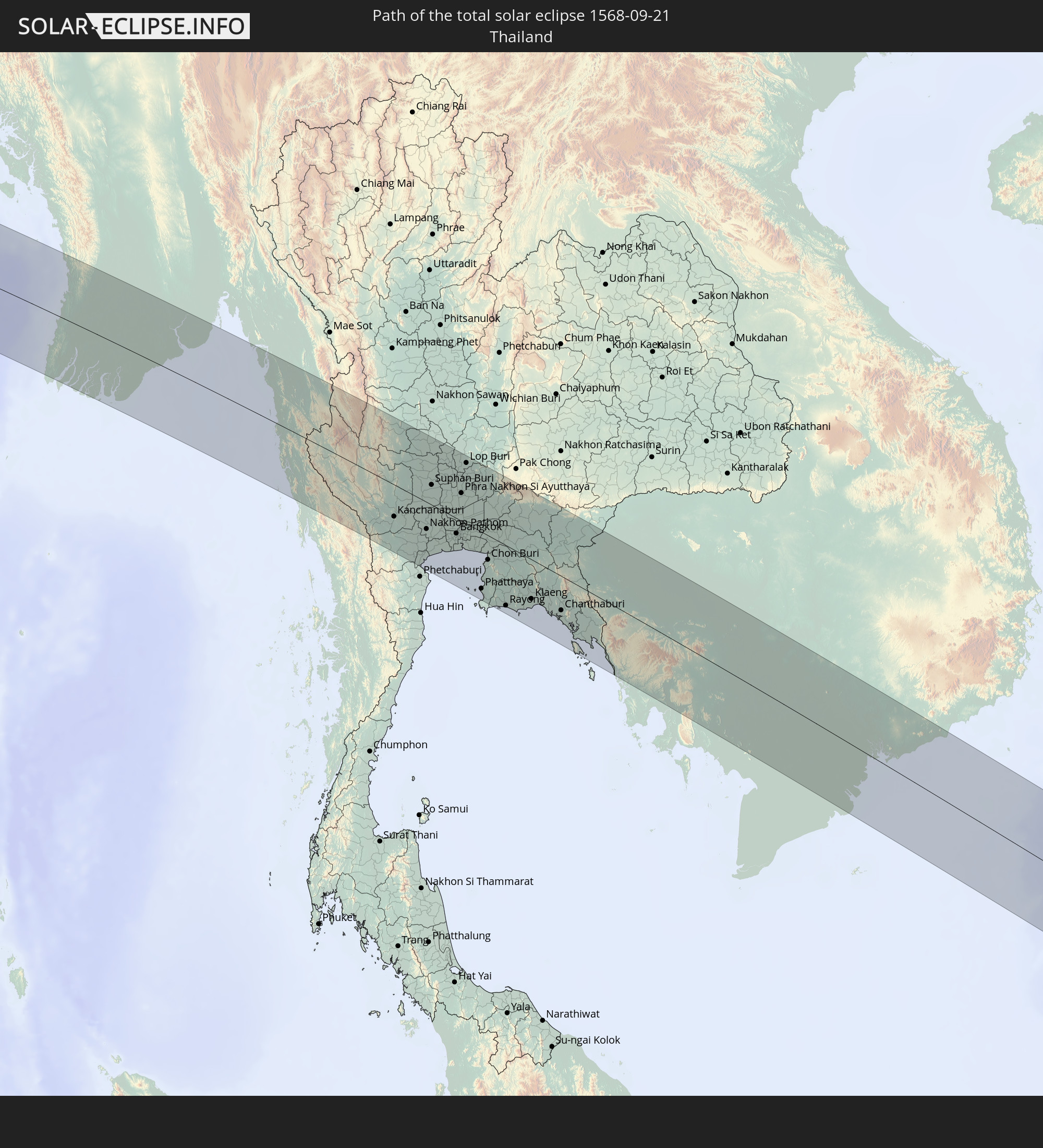 Thailand
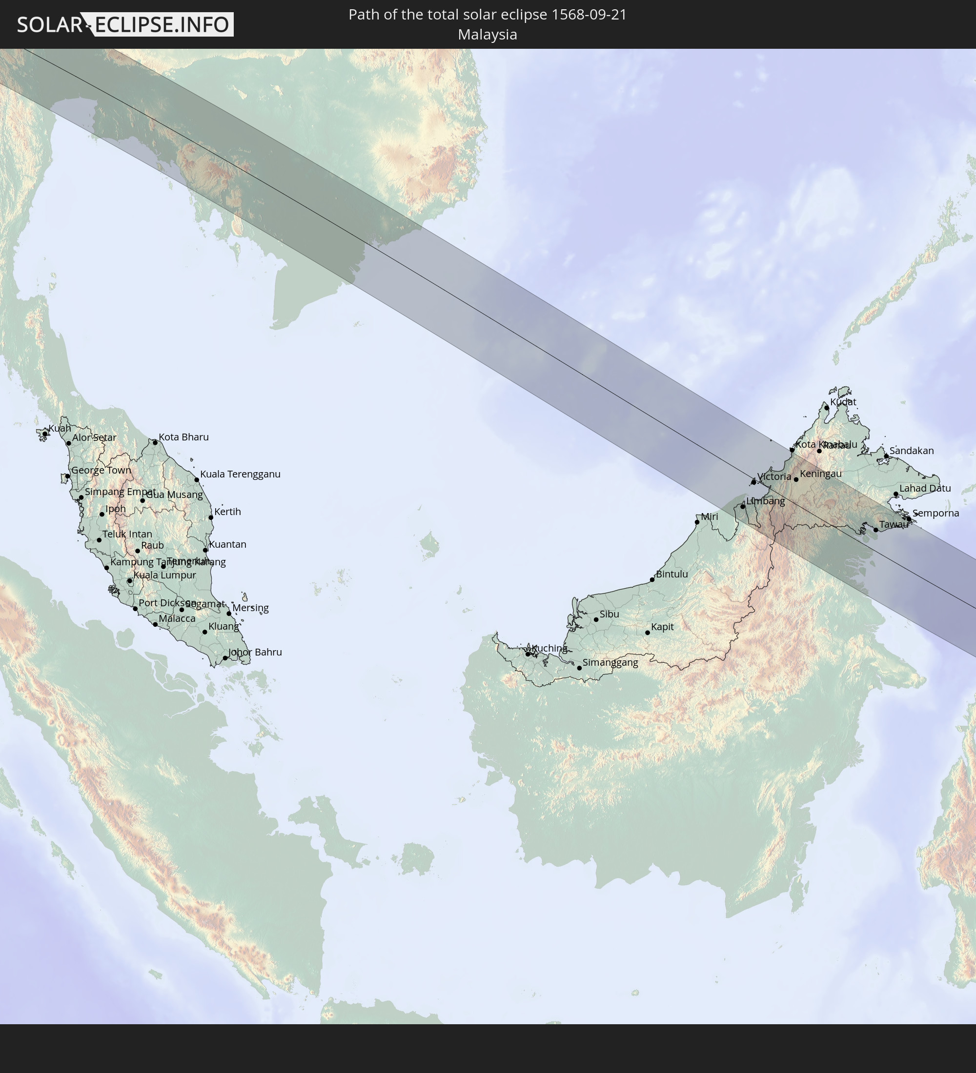 Malaysia
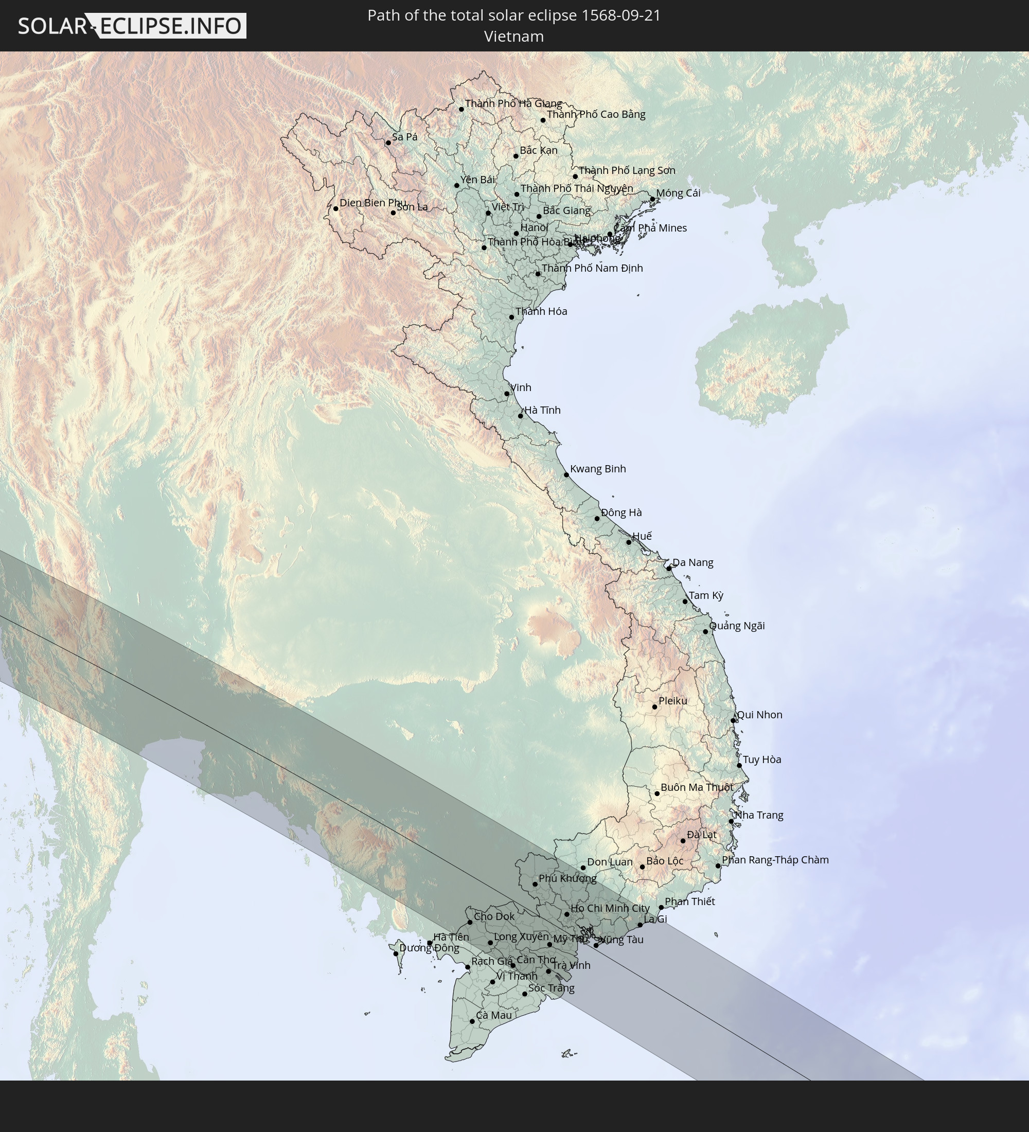 Vietnam
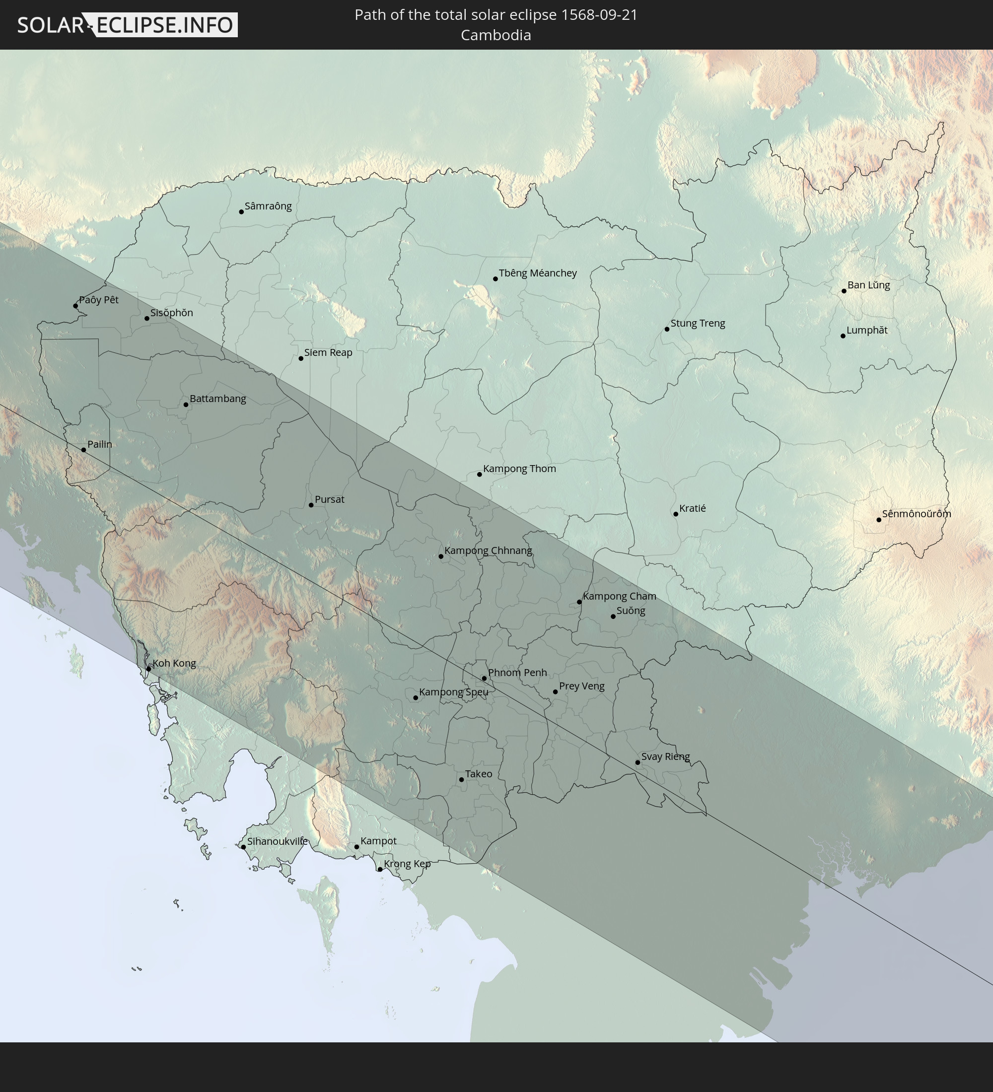 Cambodia
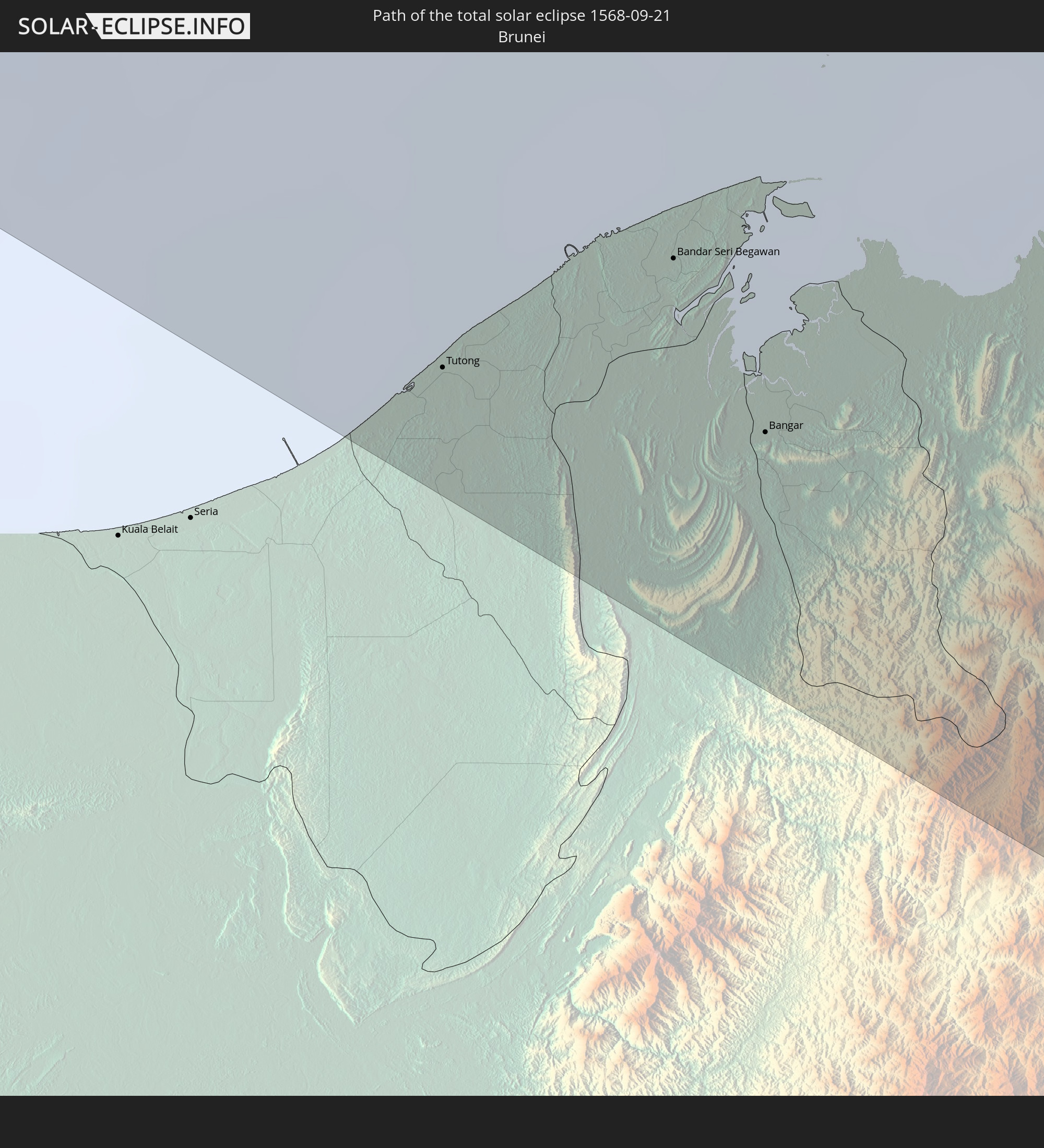 Brunei
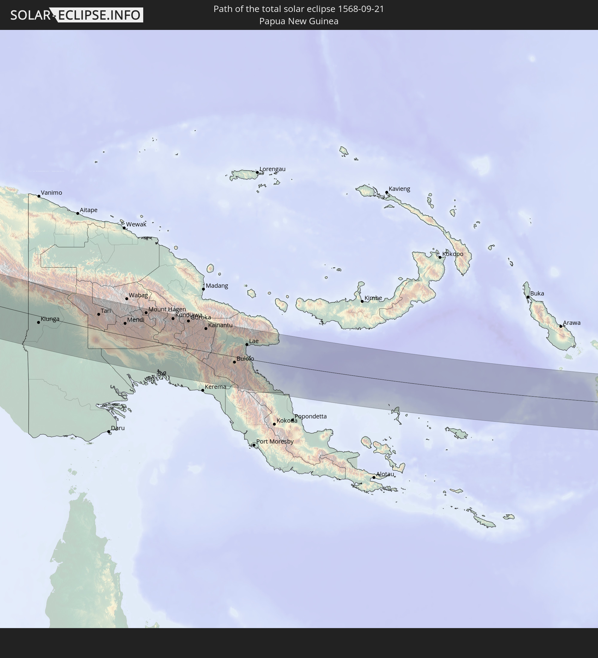 Papua New Guinea
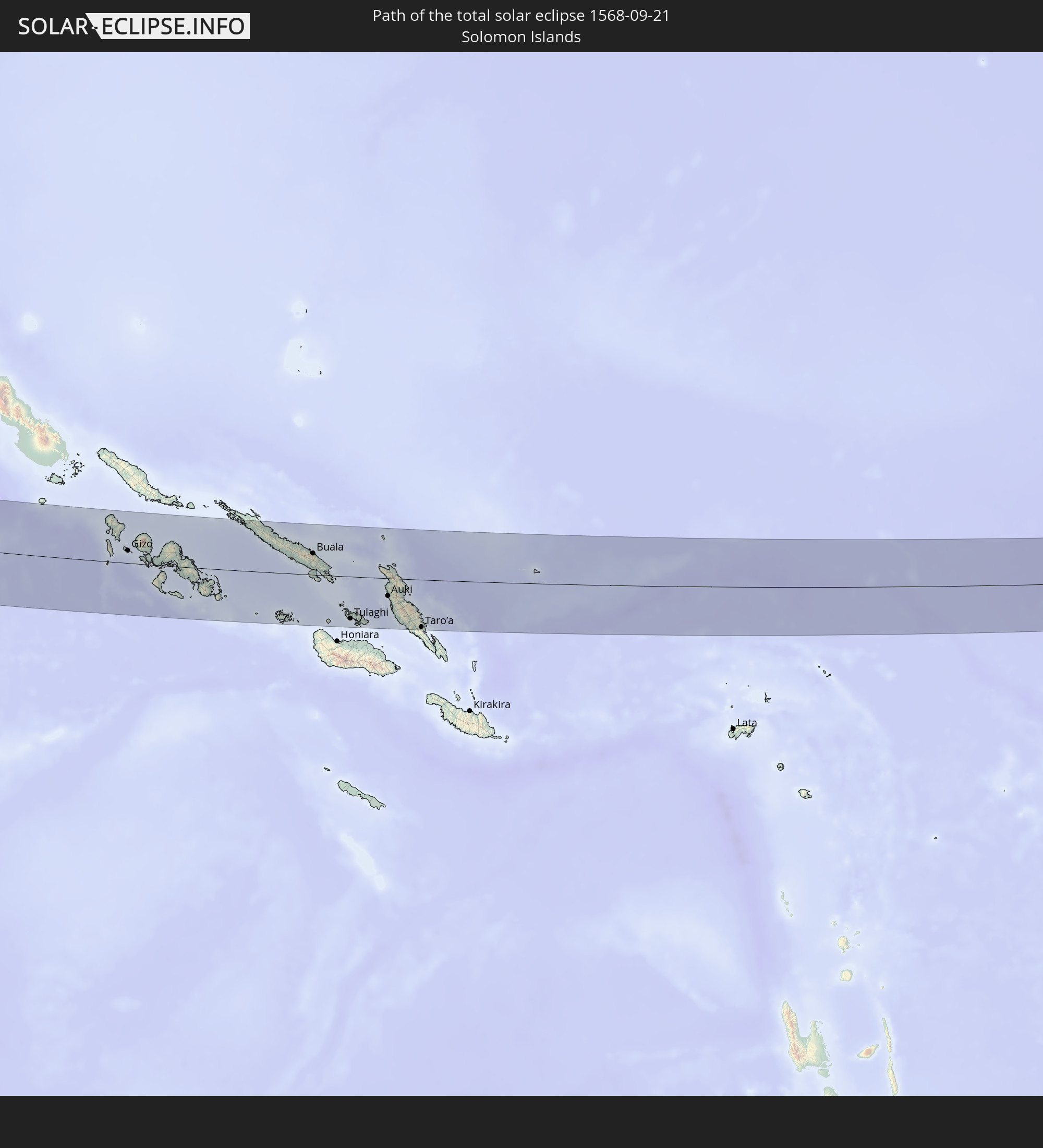 Solomon Islands
In den folgenden Ländern ist die Sonnenfinsternis partiell zu sehen
 Fiji
Fiji
 Russia
 New Zealand
 United States Minor Outlying Islands
 Kiribati
 Ethiopia
 Saudi Arabia
 Somalia
 Yemen
Yemen
 Iran
Iran
 Azerbaijan
 Seychelles
 Kazakhstan
 Bahrain
 Qatar
Qatar
 United Arab Emirates
 Oman
Oman
 Turkmenistan
 Uzbekistan
 Afghanistan
 Pakistan
 Tajikistan
 India
India
 Kyrgyzstan
 British Indian Ocean Territory
 Maldives
 China
China
 Sri Lanka
 Nepal
Nepal
 Mongolia
 Bangladesh
 Bhutan
 Myanmar
 Indonesia
 Cocos Islands
 Thailand
 Malaysia
 Laos
Laos
 Vietnam
 Cambodia
 Singapore
 Christmas Island
 Australia
 Macau
Macau
 Hong Kong
 Brunei
 Taiwan
 Philippines
 Japan
Japan
 East Timor
 North Korea
 South Korea
 Palau
Palau
 Federated States of Micronesia
 Papua New Guinea
 Guam
Guam
 Northern Mariana Islands
 Solomon Islands
 New Caledonia
 Marshall Islands
 Vanuatu
 Nauru
Nauru
 Norfolk Island
 Tuvalu
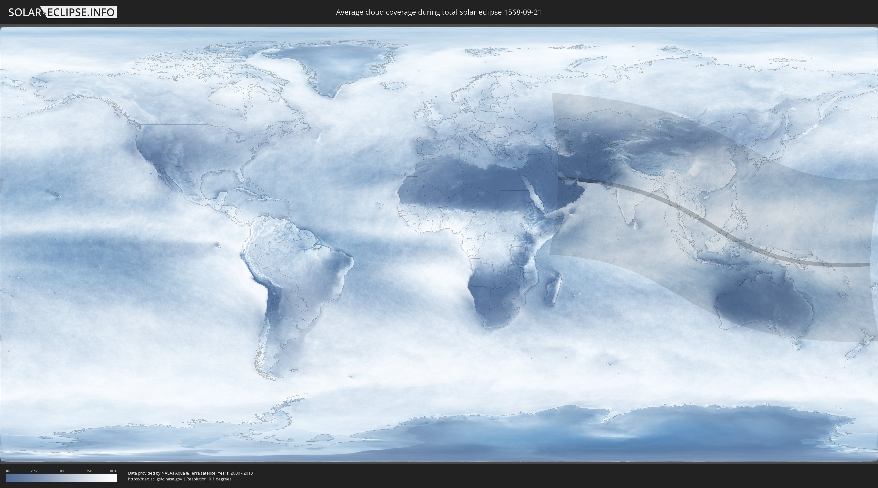
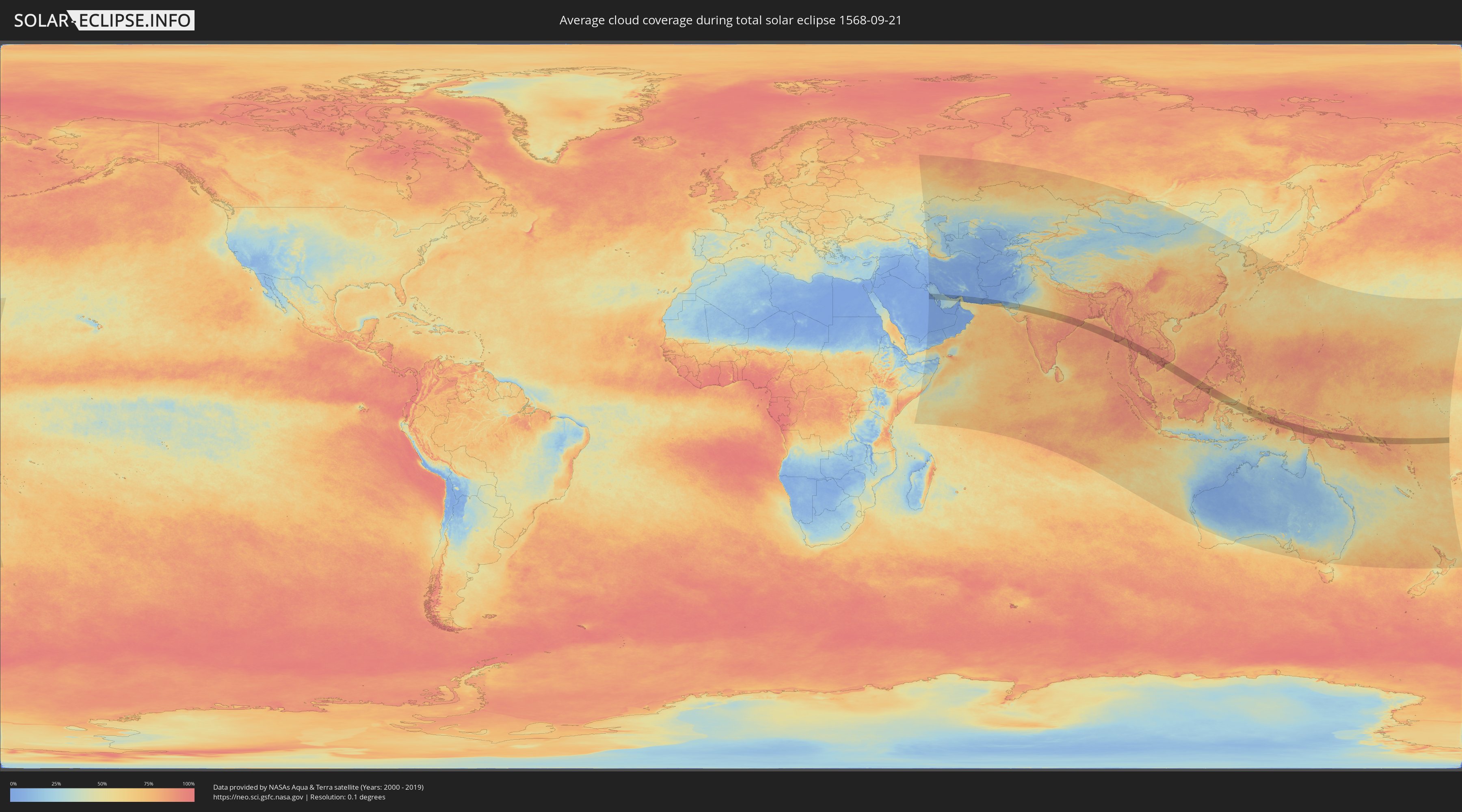
How will be the weather during the total solar eclipse on 09/21/1568?
Where is the best place to see the total solar eclipse of 09/21/1568?
The following maps show the average cloud coverage for the day of the total solar eclipse.
With the help of these maps, it is possible to find the place along the eclipse path, which has the best
chance of a cloudless sky.
Nevertheless, you should consider local circumstances and inform about the weather of your chosen
observation site.
The data is provided by NASAs satellites
AQUA and TERRA.
The cloud maps are averaged over a period of 19 years (2000 - 2019).
Detailed country maps
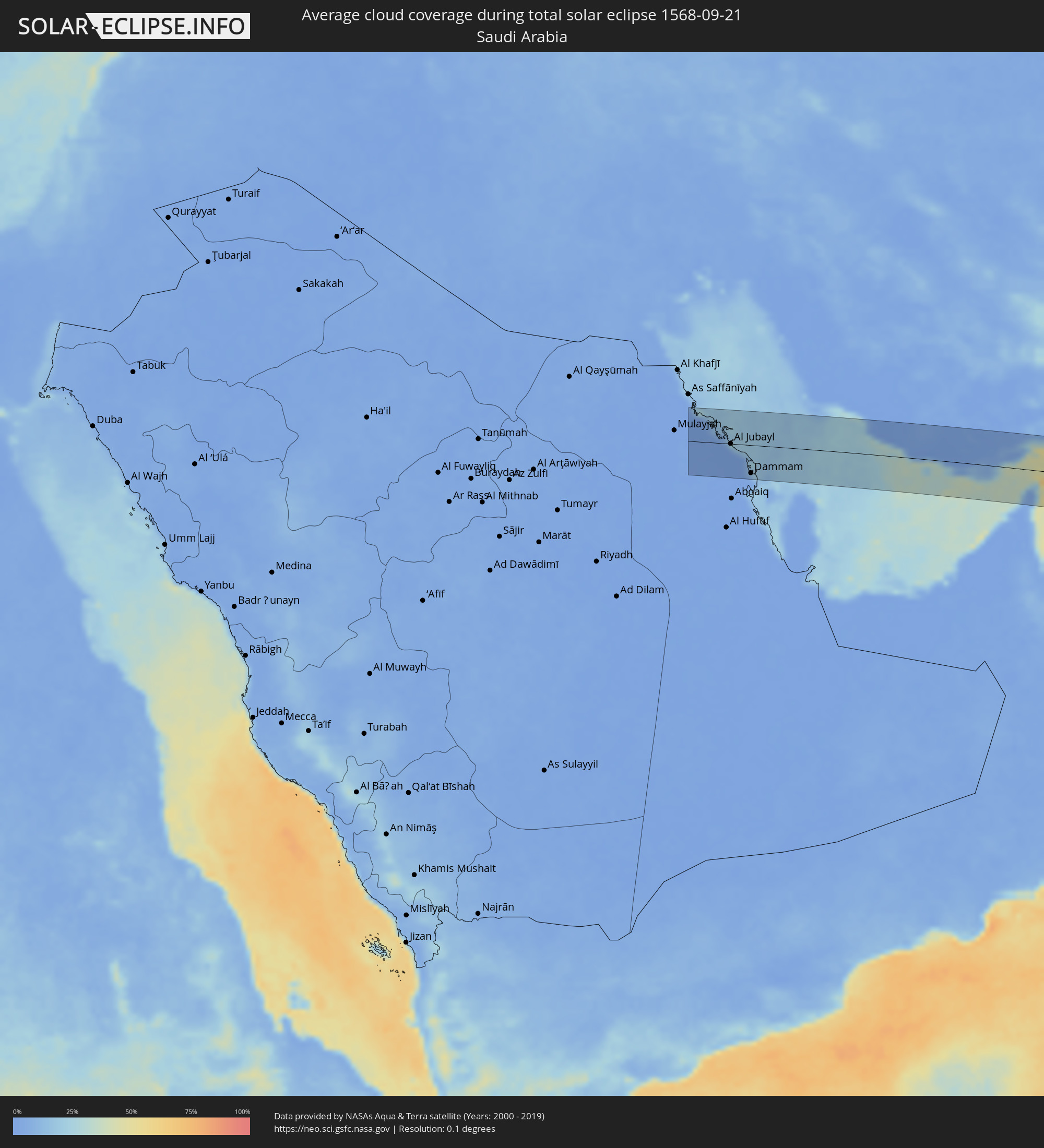 Saudi Arabia
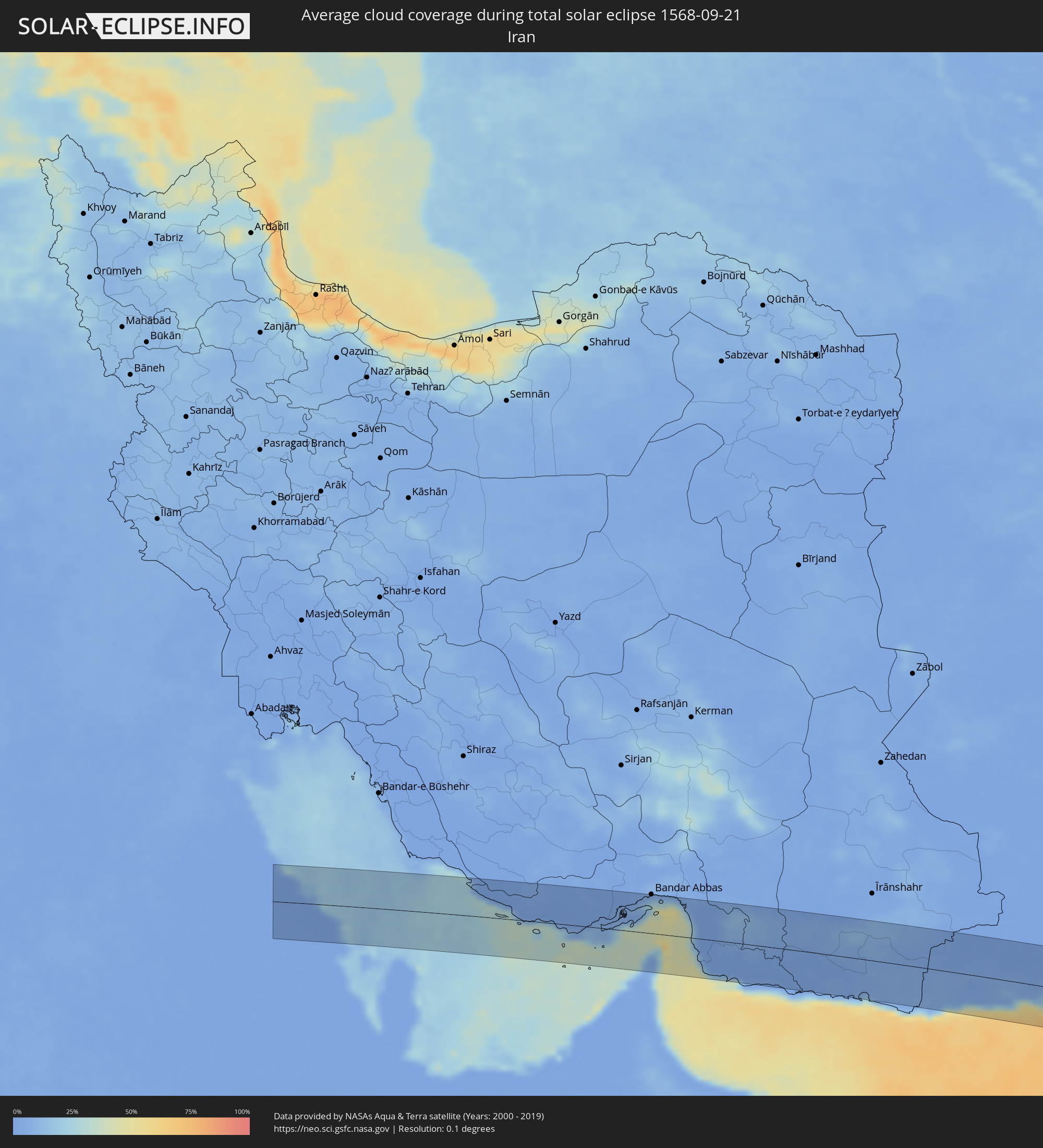 Iran
Iran
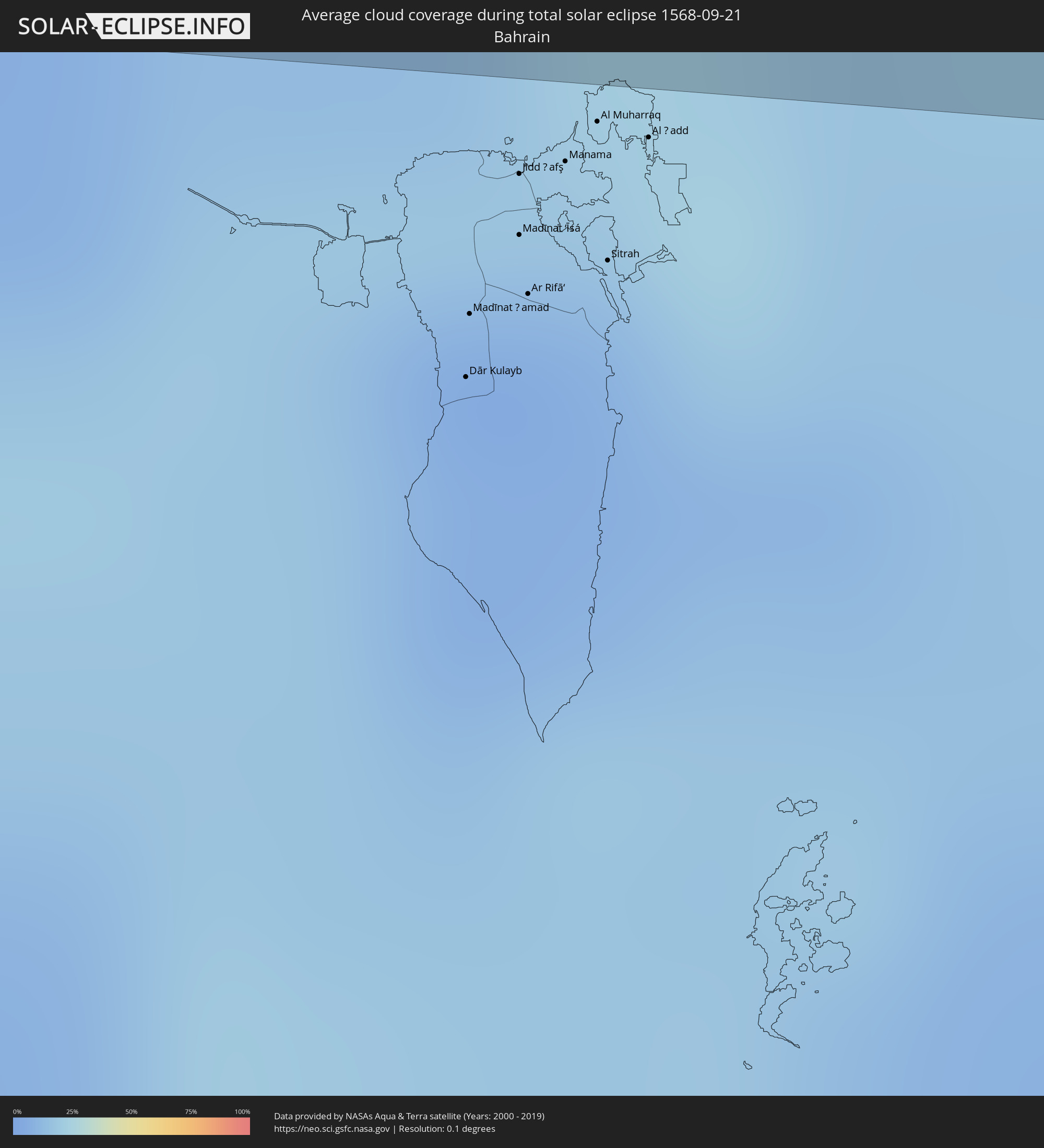 Bahrain
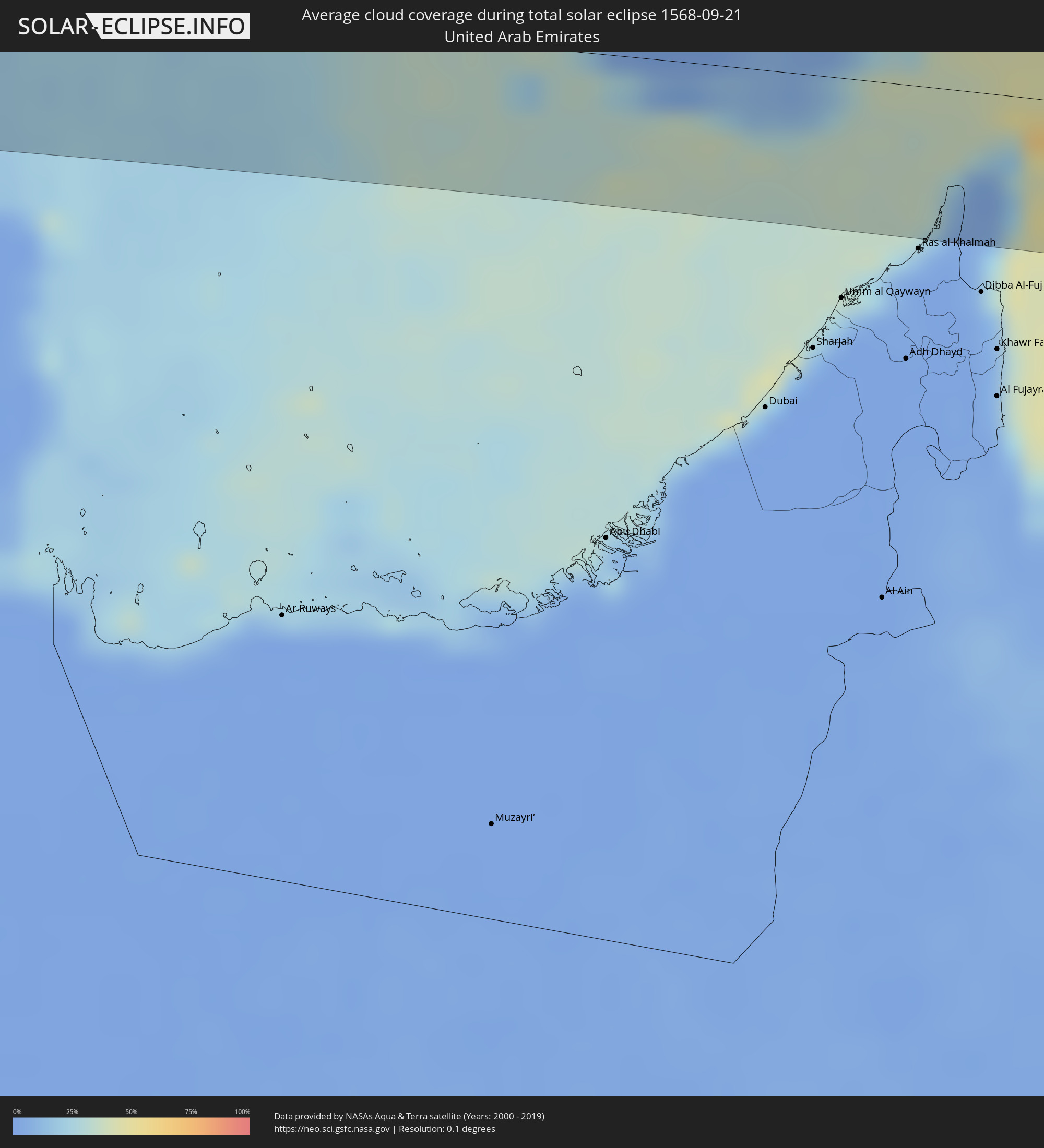 United Arab Emirates
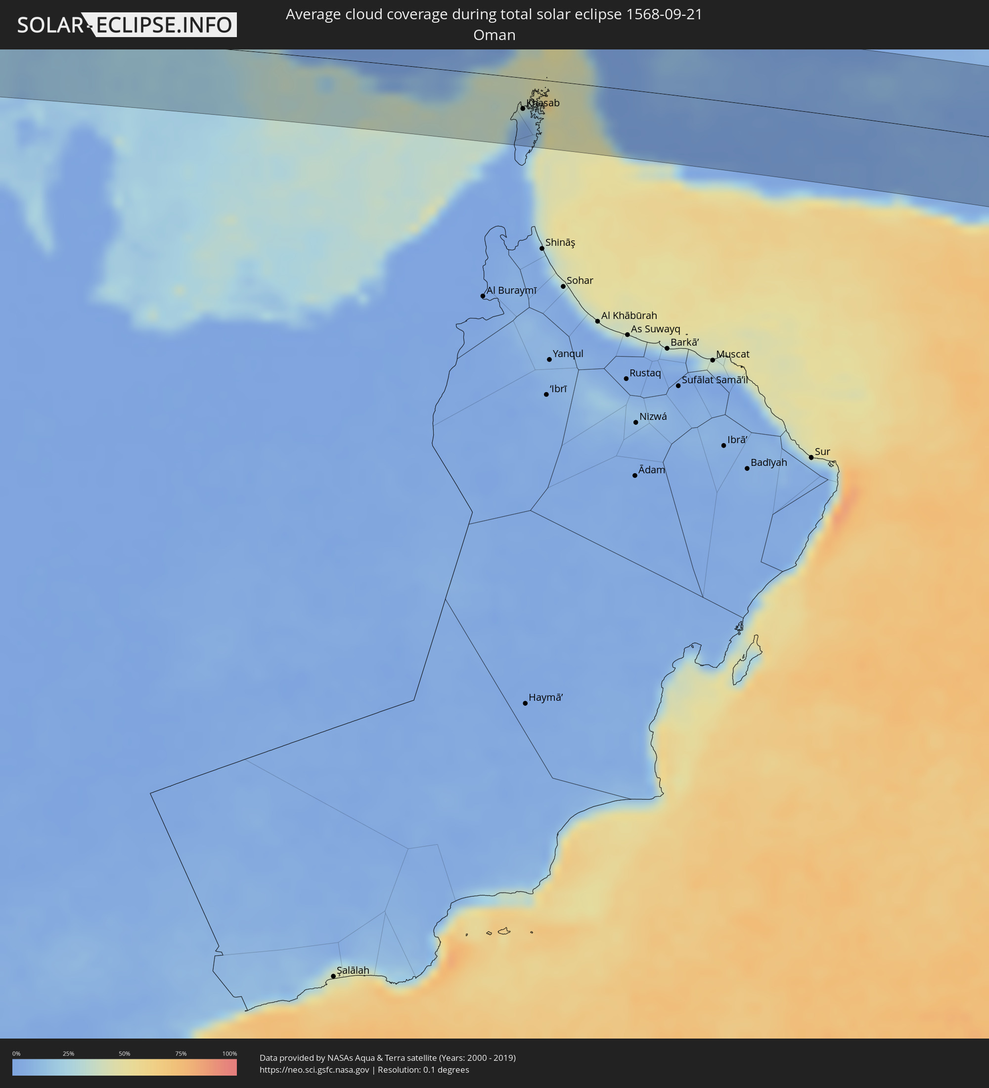 Oman
Oman
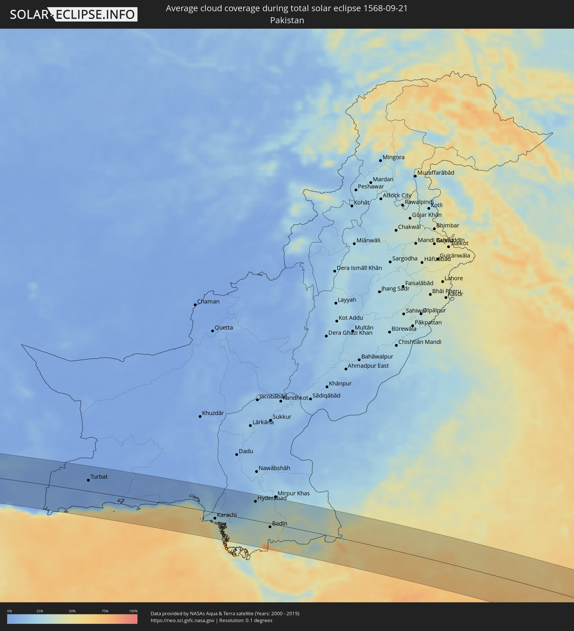 Pakistan
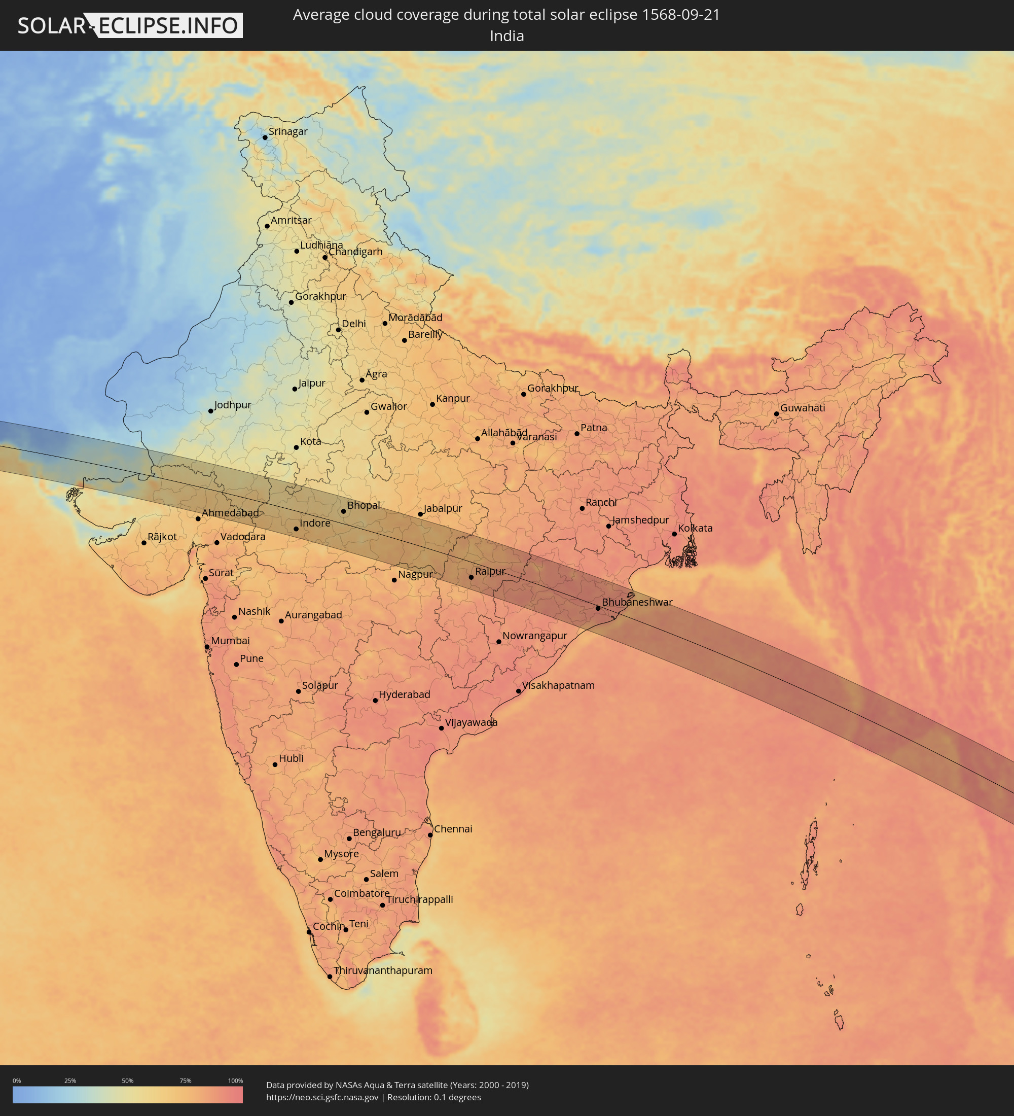 India
India
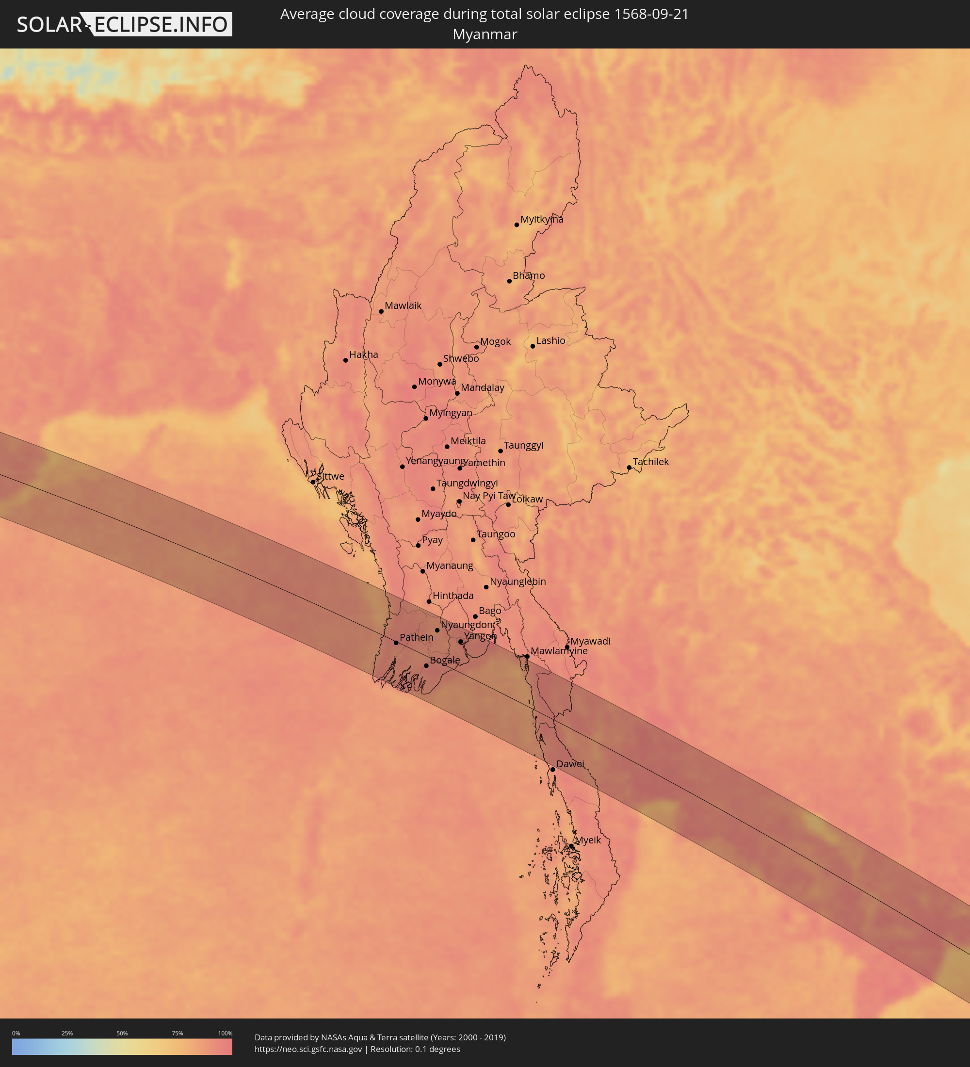 Myanmar
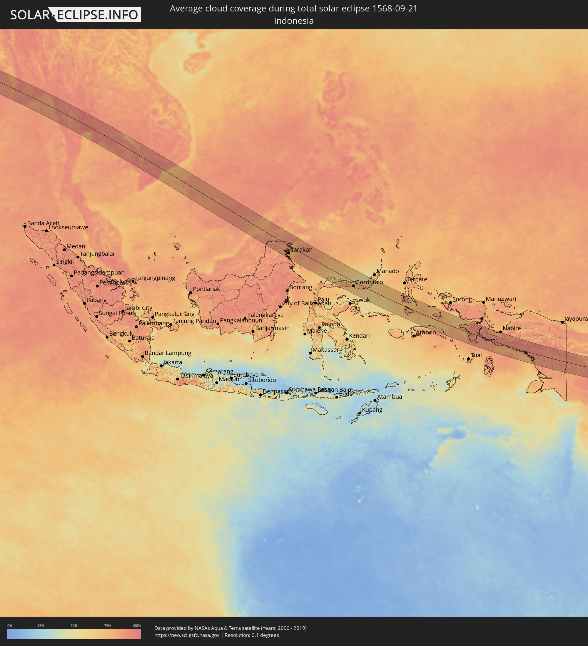 Indonesia
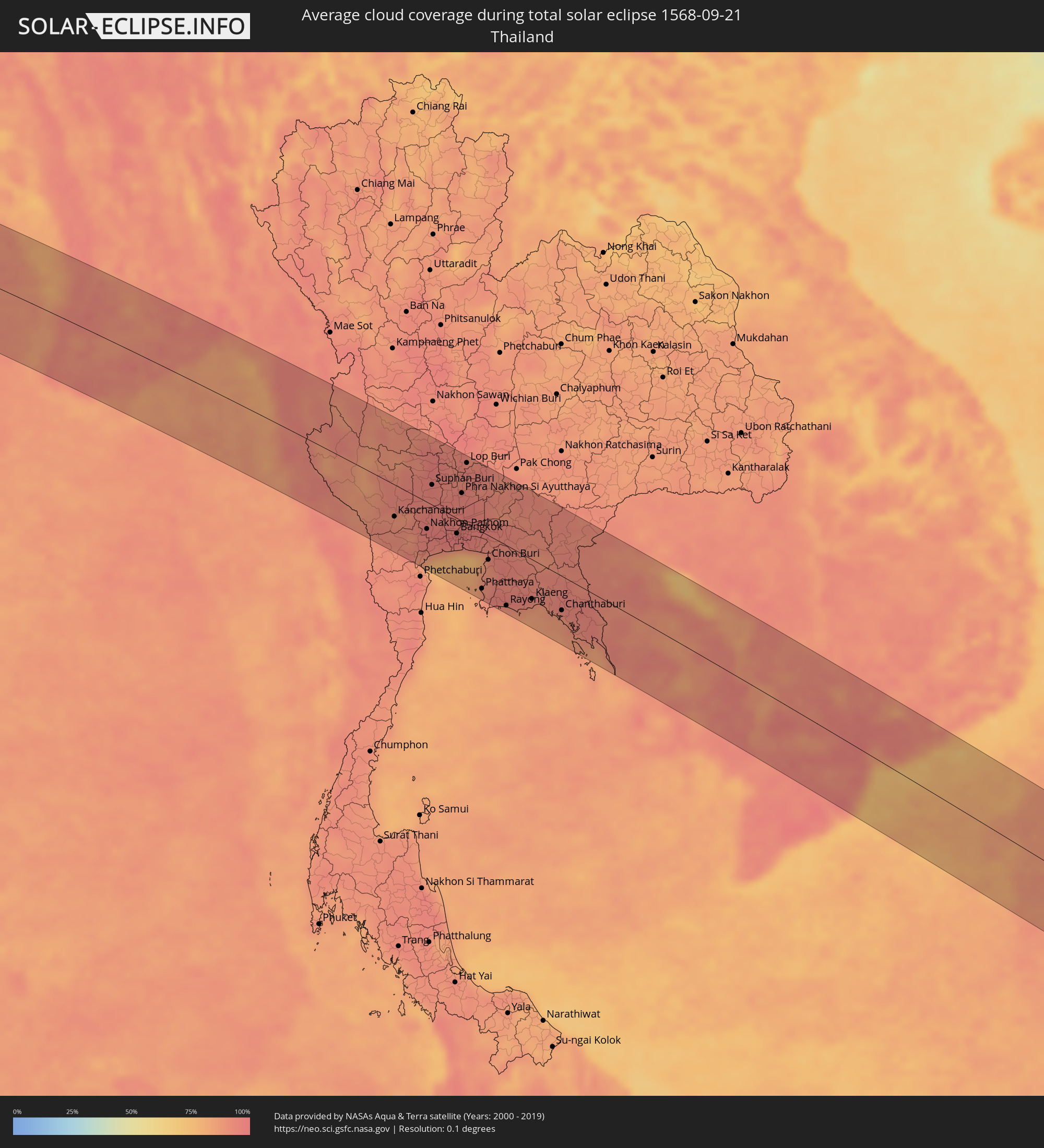 Thailand
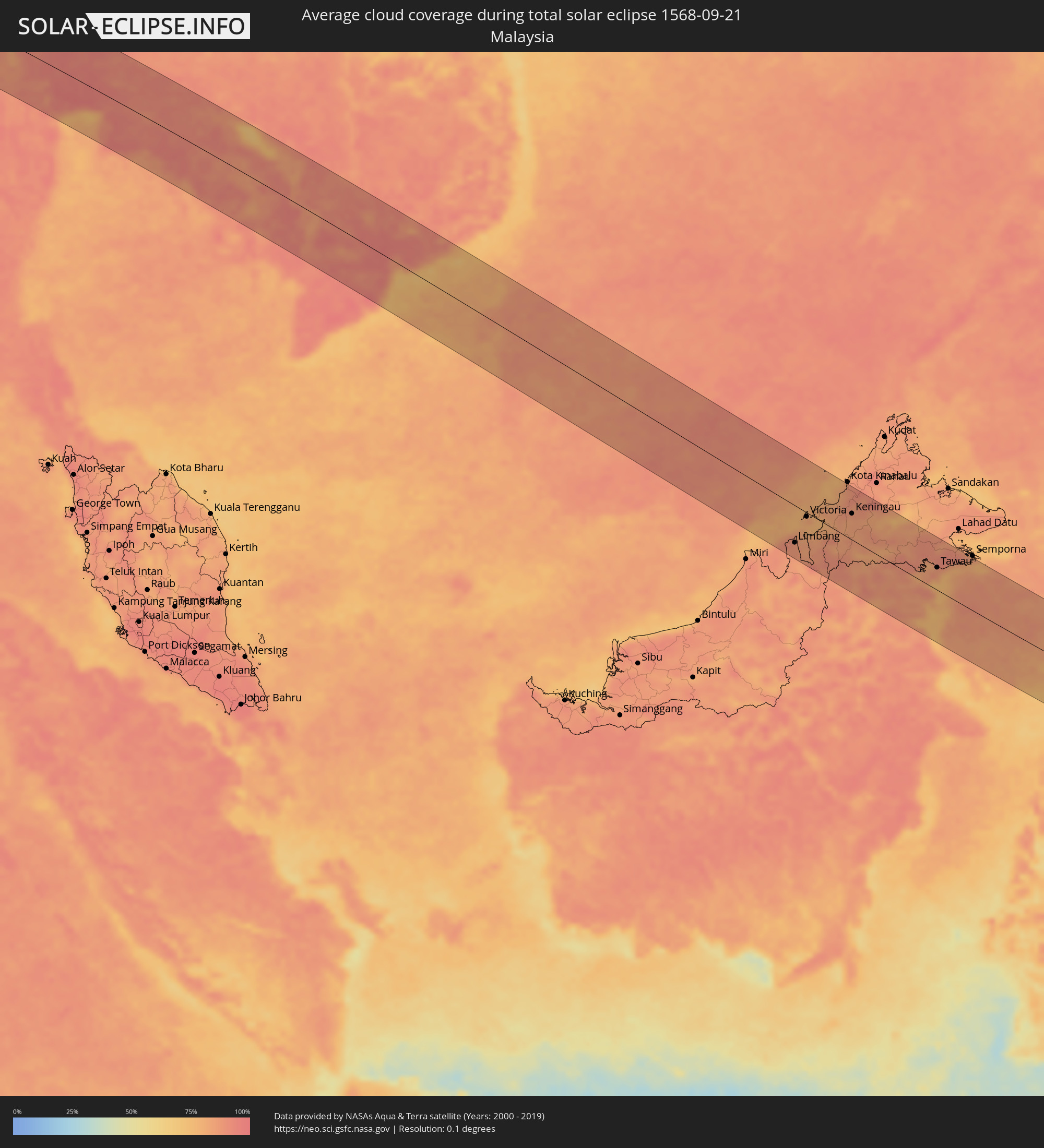 Malaysia
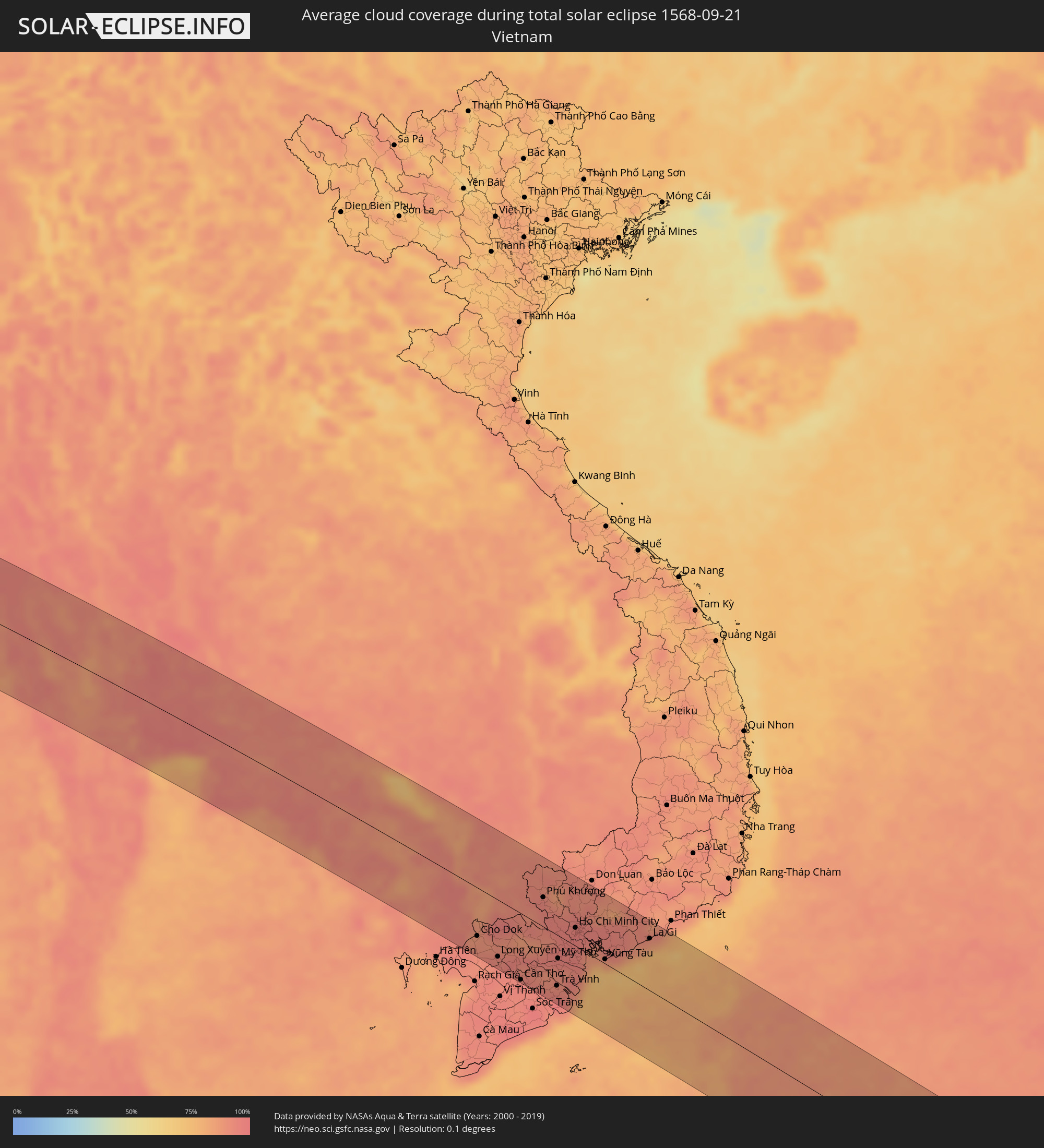 Vietnam
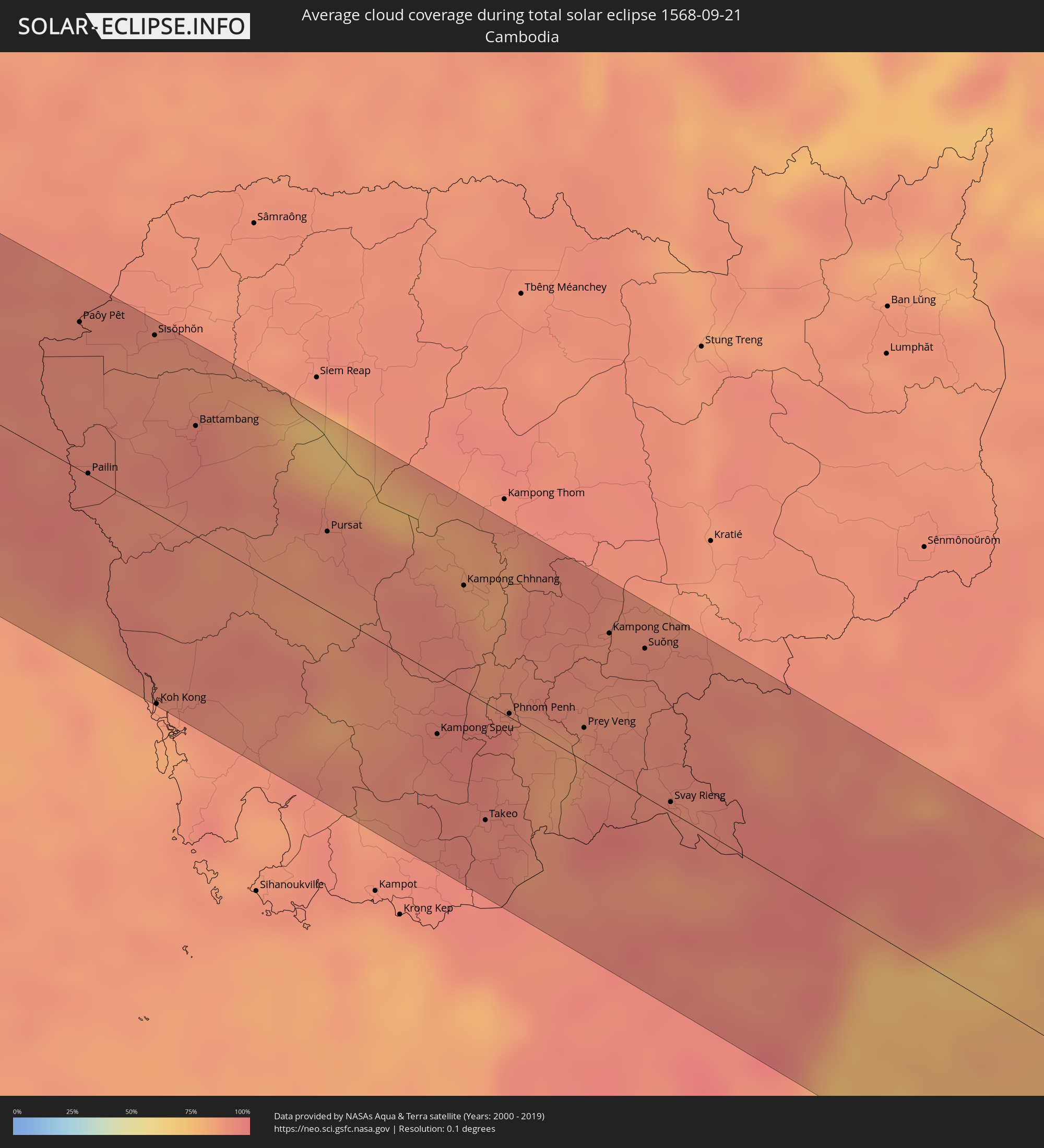 Cambodia
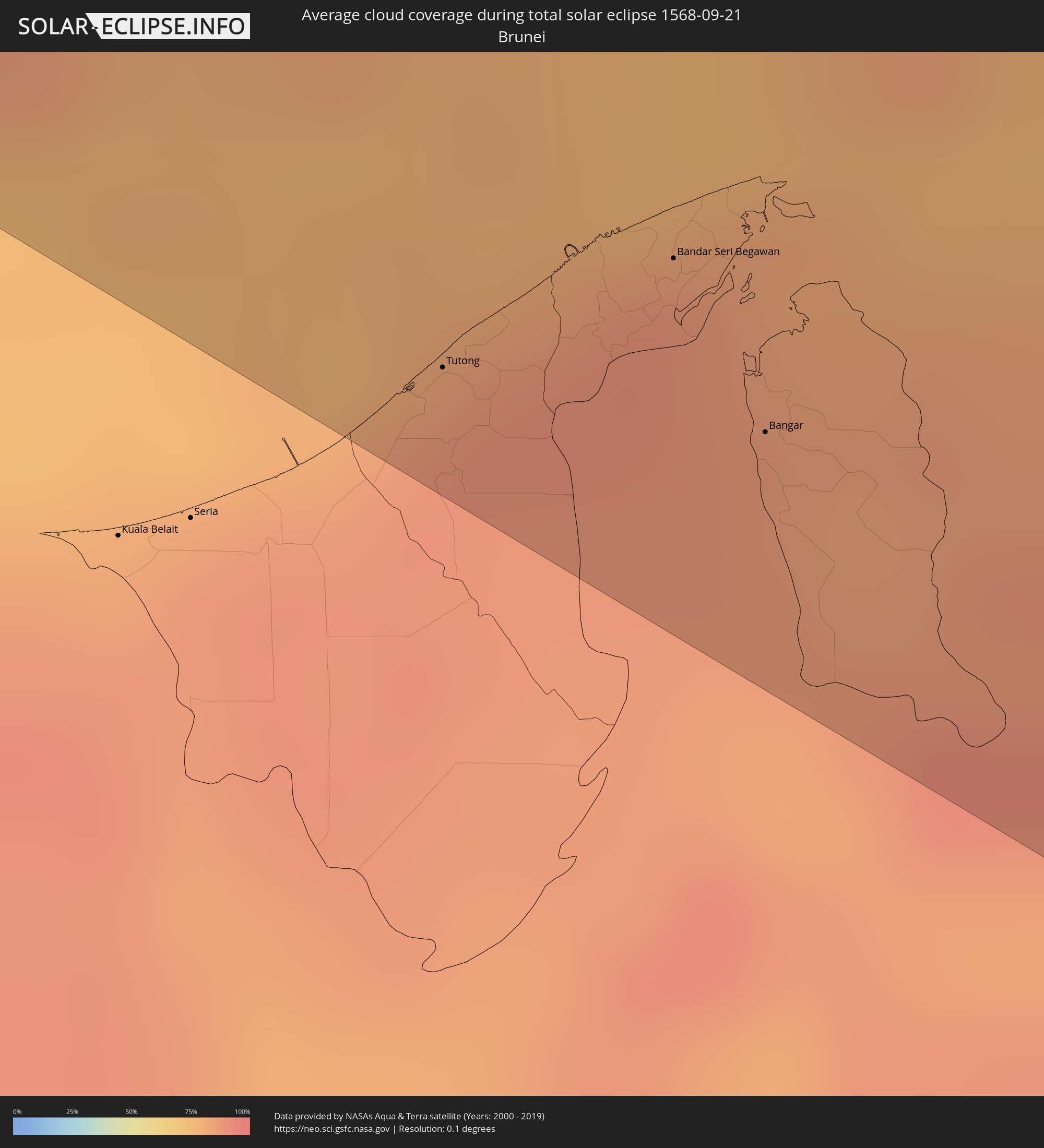 Brunei
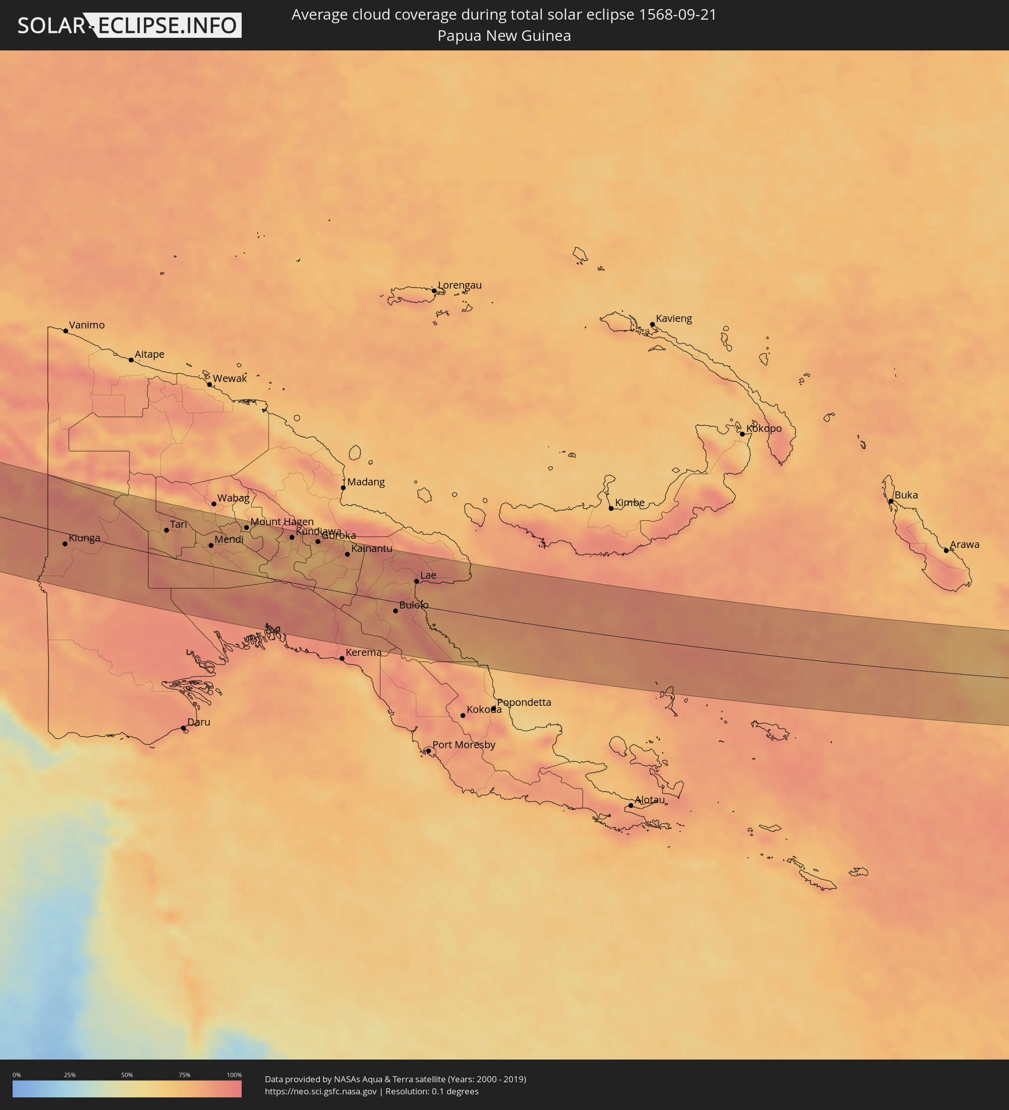 Papua New Guinea
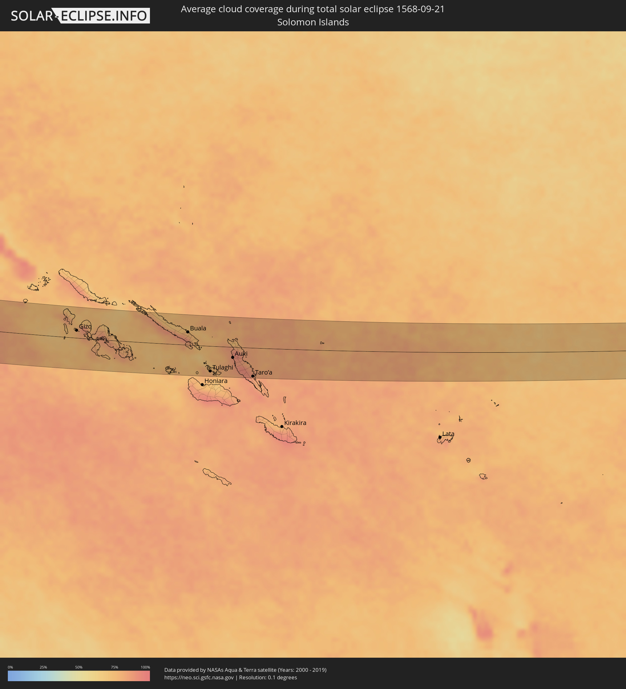 Solomon Islands
Cities inside the path of the eclipse
The following table shows all locations with a population of more than 5,000 inside the eclipse path. Cities which have more than 100,000 inhabitants are marked bold. A click at the locations opens a detailed map.
| City | Type | Eclipse duration | Local time of max. eclipse | Distance to central line | Ø Cloud coverage |
|
Al Jubayl, Eastern Province
|
total | - | 05:48:05 UTC+03:06 | 0 km | 8% |
|
Umm as Sāhik, Eastern Province
|
total | - | 05:48:00 UTC+03:06 | 38 km | 1% |
|
Al Awjām, Eastern Province
|
total | - | 05:47:59 UTC+03:06 | 48 km | 0% |
|
Şafwá, Eastern Province
|
total | - | 05:48:00 UTC+03:06 | 38 km | 5% |
|
At Tūbī, Eastern Province
|
total | - | 05:47:59 UTC+03:06 | 48 km | 5% |
|
Al Qaţīf, Eastern Province
|
total | - | 05:47:59 UTC+03:06 | 52 km | 2% |
|
Tārūt, Eastern Province
|
total | - | 05:47:59 UTC+03:06 | 46 km | 5% |
|
Sayhāt, Eastern Province
|
total | - | 05:47:58 UTC+03:06 | 56 km | 2% |
|
Raḩīmah, Eastern Province
|
total | - | 05:48:01 UTC+03:06 | 31 km | 21% |
|
Dammam, Eastern Province
|
total | - | 05:47:58 UTC+03:06 | 61 km | 2% |
|
Kīsh, Hormozgan
|
total | - | 06:07:16 UTC+03:25 | 16 km | 23% |
|
Bandar-e Lengeh, Hormozgan
|
total | - | 06:07:25 UTC+03:25 | 7 km | 10% |
|
Khasab, Musandam
|
total | - | 06:23:06 UTC+03:41 | 35 km | 9% |
|
Qeshm, Hormozgan
|
total | - | 06:07:48 UTC+03:25 | 50 km | 38% |
|
Bandar Abbas, Hormozgan
|
total | - | 06:07:51 UTC+03:25 | 77 km | 18% |
|
Qaşr-e Qand, Sistan and Baluchestan
|
total | - | 06:08:59 UTC+03:25 | 27 km | 6% |
|
Gwadar, Balochistān
|
total | - | 07:11:55 UTC+04:28 | 74 km | 60% |
|
Turbat, Balochistān
|
total | - | 07:12:21 UTC+04:28 | 34 km | 2% |
|
Pasni, Balochistān
|
total | - | 07:12:27 UTC+04:28 | 41 km | 31% |
|
Karachi, Sindh
|
total | - | 07:14:20 UTC+04:28 | 18 km | 31% |
|
Thatta, Sindh
|
total | - | 07:14:50 UTC+04:28 | 20 km | 34% |
|
Hyderabad, Sindh
|
total | - | 07:15:10 UTC+04:28 | 60 km | 21% |
|
Tando Muhammad Khān, Sindh
|
total | - | 07:15:15 UTC+04:28 | 33 km | 28% |
|
Tando Jām, Sindh
|
total | - | 07:15:16 UTC+04:28 | 67 km | 24% |
|
Mātli, Sindh
|
total | - | 07:15:19 UTC+04:28 | 27 km | 34% |
|
Tando Allāhyār, Sindh
|
total | - | 07:15:23 UTC+04:28 | 74 km | 23% |
|
Badīn, Sindh
|
total | - | 07:15:26 UTC+04:28 | 12 km | 37% |
|
Digri, Sindh
|
total | - | 07:15:38 UTC+04:28 | 48 km | 31% |
|
Naukot, Sindh
|
total | - | 07:15:49 UTC+04:28 | 22 km | 36% |
|
Kunri, Sindh
|
total | - | 07:15:56 UTC+04:28 | 60 km | 35% |
|
Mithi, Sindh
|
total | - | 07:16:05 UTC+04:28 | 17 km | 32% |
|
Ratlām, Madhya Pradesh
|
total | - | 08:13:19 UTC+05:21 | 15 km | 65% |
|
Ujjain, Madhya Pradesh
|
total | - | 08:14:02 UTC+05:21 | 12 km | 67% |
|
Indore, Madhya Pradesh
|
total | - | 08:14:09 UTC+05:21 | 61 km | 72% |
|
Dewas, Madhya Pradesh
|
total | - | 08:14:19 UTC+05:21 | 28 km | 67% |
|
Bhopal, Madhya Pradesh
|
total | - | 08:15:37 UTC+05:21 | 39 km | 61% |
|
Vidisha, Madhya Pradesh
|
total | - | 08:15:59 UTC+05:21 | 79 km | 63% |
|
Rāj-Nāndgaon, Chhattisgarh
|
total | - | 08:20:07 UTC+05:21 | 85 km | 79% |
|
Durg, Chhattisgarh
|
total | - | 08:20:23 UTC+05:21 | 67 km | 80% |
|
Bhilai, Chhattisgarh
|
total | - | 08:20:34 UTC+05:21 | 60 km | 81% |
|
Raipur, Chhattisgarh
|
total | - | 08:20:49 UTC+05:21 | 51 km | 81% |
|
Bilāspur, Chhattisgarh
|
total | - | 08:21:12 UTC+05:21 | 55 km | 80% |
|
Sambalpur, Odisha
|
total | - | 08:23:43 UTC+05:21 | 50 km | 87% |
|
Puri, Odisha
|
total | - | 08:26:57 UTC+05:21 | 59 km | 80% |
|
Bhubaneshwar, Odisha
|
total | - | 08:26:45 UTC+05:21 | 10 km | 93% |
|
Cuttack, Odisha
|
total | - | 08:26:44 UTC+05:21 | 12 km | 89% |
|
Pathein, Ayeyarwady
|
total | - | 09:47:22 UTC+06:24 | 4 km | 89% |
|
Wakema, Ayeyarwady
|
total | - | 09:48:22 UTC+06:24 | 1 km | 88% |
|
Bogale, Ayeyarwady
|
total | - | 09:49:03 UTC+06:24 | 22 km | 94% |
|
Nyaungdon, Ayeyarwady
|
total | - | 09:48:52 UTC+06:24 | 65 km | 90% |
|
Maubin, Ayeyarwady
|
total | - | 09:49:10 UTC+06:24 | 34 km | 89% |
|
Pyapon, Ayeyarwady
|
total | - | 09:49:36 UTC+06:24 | 9 km | 92% |
|
Kyaiklat, Ayeyarwady
|
total | - | 09:49:33 UTC+06:24 | 9 km | 92% |
|
Twante, Yangon
|
total | - | 09:49:43 UTC+06:24 | 45 km | 91% |
|
Kanbe, Yangon
|
total | - | 09:49:51 UTC+06:24 | 48 km | 92% |
|
Yangon, Yangon
|
total | - | 09:50:04 UTC+06:24 | 65 km | 94% |
|
Syriam, Yangon
|
total | - | 09:50:17 UTC+06:24 | 66 km | 94% |
|
Thongwa, Yangon
|
total | - | 09:50:50 UTC+06:24 | 78 km | 92% |
|
Kayan, Yangon
|
total | - | 09:50:46 UTC+06:24 | 94 km | 94% |
|
Kyaikkami, Mon
|
total | - | 09:53:31 UTC+06:24 | 60 km | 85% |
|
Mudon, Mon
|
total | - | 09:53:41 UTC+06:24 | 85 km | 91% |
|
Kanchanaburi, Kanchanaburi
|
total | - | 10:17:02 UTC+06:42 | 46 km | 90% |
|
Ratchaburi, Ratchaburi
|
total | - | 10:18:08 UTC+06:42 | 79 km | 94% |
|
Nakhon Pathom, Nakhon Pathom
|
total | - | 10:18:19 UTC+06:42 | 39 km | 94% |
|
Krathum Baen, Samut Sakhon
|
total | - | 10:18:58 UTC+06:42 | 44 km | 96% |
|
Pak Kret, Nonthaburi
|
total | - | 10:19:12 UTC+06:42 | 7 km | 95% |
|
Bangkok, Bangkok
|
total | - | 10:19:23 UTC+06:42 | 22 km | 96% |
|
Phra Nakhon Si Ayutthaya, Phra Nakhon Si Ayutthaya
|
total | - | 10:18:53 UTC+06:42 | 40 km | 95% |
|
Samut Prakan, Samut Prakan
|
total | - | 10:19:46 UTC+06:42 | 32 km | 89% |
|
Khlong Luang, Pathum Thani
|
total | - | 10:19:21 UTC+06:42 | 16 km | 96% |
|
Phatthaya, Chon Buri
|
total | - | 10:21:09 UTC+06:42 | 82 km | 88% |
|
Saraburi, Sara Buri
|
total | - | 10:19:26 UTC+06:42 | 76 km | 92% |
|
Si Racha, Chon Buri
|
total | - | 10:20:59 UTC+06:42 | 56 km | 88% |
|
Chon Buri, Chon Buri
|
total | - | 10:20:53 UTC+06:42 | 35 km | 92% |
|
Rayong, Rayong
|
total | - | 10:22:17 UTC+06:42 | 87 km | 91% |
|
Chanthaburi, Chanthaburi
|
total | - | 10:24:17 UTC+06:42 | 49 km | 92% |
|
Paôy Pêt, Banteay Meanchey
|
total | - | 10:24:05 UTC+06:42 | 76 km | 92% |
|
Sisŏphŏn, Banteay Meanchey
|
total | - | 10:25:05 UTC+06:42 | 91 km | 90% |
|
Koh Kong, Koh Kong
|
total | - | 10:27:31 UTC+06:42 | 99 km | 84% |
|
Battambang, Battambang
|
total | - | 10:26:11 UTC+06:42 | 57 km | 94% |
|
Pursat, Pursat
|
total | - | 10:28:32 UTC+06:42 | 41 km | 88% |
|
Kampong Speu, Kampong Speu
|
total | - | 10:31:20 UTC+06:42 | 31 km | 94% |
|
Kampong Chhnang, Kampong Chhnang
|
total | - | 10:30:39 UTC+06:42 | 54 km | 85% |
|
Phumĭ Véal Srê, Takeo
|
total | - | 10:32:33 UTC+06:42 | 62 km | 92% |
|
Takeo, Takeo
|
total | - | 10:32:34 UTC+06:42 | 60 km | 92% |
|
Phnom Penh, Phnom Penh
|
total | - | 10:32:07 UTC+06:42 | 2 km | 95% |
|
Ta Khmau, Kandal
|
total | - | 10:32:18 UTC+06:42 | 4 km | 87% |
|
Cho Dok, An Giang
|
total | - | 10:58:20 UTC+07:06 | 70 km | 90% |
|
Prey Veng, Prey Veng
|
total | - | 10:33:12 UTC+06:42 | 17 km | 84% |
|
Long Xuyên, An Giang
|
total | - | 10:59:31 UTC+07:06 | 82 km | 94% |
|
Kampong Cham, Kampong Cham
|
total | - | 10:32:52 UTC+06:42 | 73 km | 90% |
|
Cao Lãnh, Đồng Tháp
|
total | - | 10:59:54 UTC+07:06 | 64 km | 95% |
|
Suŏng, Tboung Khmum
|
total | - | 10:33:26 UTC+06:42 | 76 km | 90% |
|
Sadek, Đồng Tháp
|
total | - | 11:00:26 UTC+07:06 | 74 km | 92% |
|
Cần Thơ, Cần Thơ
|
total | - | 11:00:51 UTC+07:06 | 96 km | 94% |
|
Svay Rieng, Svay Rieng
|
total | - | 10:34:52 UTC+06:42 | 5 km | 92% |
|
Vĩnh Long, Vĩnh Long
|
total | - | 11:01:00 UTC+07:06 | 65 km | 92% |
|
Mỹ Tho, Tiền Giang
|
total | - | 11:01:48 UTC+07:06 | 33 km | 94% |
|
Tân An, Long An
|
total | - | 11:01:42 UTC+07:06 | 13 km | 96% |
|
Củ Chi, Ho Chi Minh City
|
total | - | 11:01:18 UTC+07:06 | 33 km | 95% |
|
Ho Chi Minh City, Ho Chi Minh City
|
total | - | 11:01:50 UTC+07:06 | 26 km | 97% |
|
Thủ Dầu Một, Bình Dương
|
total | - | 11:01:40 UTC+07:06 | 43 km | 96% |
|
Cần Giuộc, Long An
|
total | - | 11:02:14 UTC+07:06 | 8 km | 94% |
|
Biên Hòa, Đồng Nai
|
total | - | 11:02:09 UTC+07:06 | 49 km | 96% |
|
Vũng Tàu, Bà Rịa-Vũng Tàu
|
total | - | 11:03:36 UTC+07:06 | 6 km | 73% |
|
La Gi, Bình Thuận
|
total | - | 11:04:51 UTC+07:06 | 75 km | 83% |
|
Tutong, Tutong
|
total | - | 12:04:10 UTC+07:39 | 87 km | 89% |
|
Bandar Seri Begawan, Brunei and Muara
|
total | - | 12:04:44 UTC+07:39 | 56 km | 90% |
|
Limbang, Sarawak
|
total | - | 11:46:50 UTC+07:21 | 72 km | 87% |
|
Bangar, Temburong
|
total | - | 12:05:23 UTC+07:39 | 71 km | 85% |
|
Victoria, Labuan
|
total | - | 11:46:38 UTC+07:21 | 8 km | 81% |
|
Bandar Labuan, Sabah
|
total | - | 11:46:42 UTC+07:21 | 5 km | 83% |
|
Beaufort, Sabah
|
total | - | 11:47:51 UTC+07:21 | 28 km | 81% |
|
Papar, Sabah
|
total | - | 11:47:44 UTC+07:21 | 76 km | 82% |
|
Kinarut, Sabah
|
total | - | 11:47:54 UTC+07:21 | 91 km | 84% |
|
Putatan, Sabah
|
total | - | 11:47:46 UTC+07:21 | 101 km | 87% |
|
Donggongon, Sabah
|
total | - | 11:47:54 UTC+07:21 | 102 km | 87% |
|
Keningau, Sabah
|
total | - | 11:48:57 UTC+07:21 | 51 km | 84% |
|
Sembakung, East Kalimantan
|
total | - | 12:30:24 UTC+07:57 | 33 km | 86% |
|
Tarakan, North Kalimantan
|
total | - | 12:32:04 UTC+07:57 | 63 km | 78% |
|
Tawau, Sabah
|
total | - | 11:55:08 UTC+07:21 | 44 km | 84% |
|
Gorontalo, Gorontalo
|
total | - | 12:50:10 UTC+07:57 | 39 km | 70% |
|
Kiunga, Western Province
|
total | - | 15:37:51 UTC+10:00 | 20 km | 86% |
|
Tari, Hela
|
total | - | 15:40:11 UTC+10:00 | 45 km | 79% |
|
Mendi, Southern Highlands
|
total | - | 15:41:26 UTC+10:00 | 35 km | 81% |
|
Ialibu, Southern Highlands
|
total | - | 15:42:01 UTC+10:00 | 28 km | 81% |
|
Mount Hagen, Western Highlands
|
total | - | 15:42:02 UTC+10:00 | 80 km | 74% |
|
Minj, Jiwaka
|
total | - | 15:42:43 UTC+10:00 | 85 km | 77% |
|
Kundiawa, Chimbu
|
total | - | 15:43:11 UTC+10:00 | 79 km | 77% |
|
Goroka, Eastern Highlands
|
total | - | 15:43:48 UTC+10:00 | 80 km | 70% |
|
Kainantu, Eastern Highlands
|
total | - | 15:44:35 UTC+10:00 | 68 km | 80% |
|
Bulolo, Morobe
|
total | - | 15:46:13 UTC+10:00 | 17 km | 78% |
|
Wau, Morobe
|
total | - | 15:46:23 UTC+10:00 | 31 km | 83% |
|
Lae, Morobe
|
total | - | 15:46:20 UTC+10:00 | 42 km | 81% |
|
Gizo, Western Province
|
total | - | 16:36:48 UTC+10:39 | 20 km | 76% |
|
Buala, Isabel
|
total | - | 16:38:45 UTC+10:39 | 35 km | 78% |
|
Tulaghi, Central Province
|
total | - | 16:39:28 UTC+10:39 | 68 km | 79% |
|
Auki, Malaita
|
total | - | 16:39:41 UTC+10:39 | 29 km | 85% |
|
Taro’a, Choiseul
|
total | - | 16:40:08 UTC+10:39 | 77 km | 85% |